/


Текст
UNEP WCMC
World Atlas of Coral Reefs
Mark D. Spalding. Corinna Ravilious. and Ednnund P. Green
The most definitive and comprehensive
overview yet of a vital part of our
living w/orld." -- BBC Wildlife
®iral reefs
are the most biologically
diverse marine habitats in the world, host to an
extraordinary variety of plants and animals. They are
also one of the world's most fragile and endangered
ecosystems. The growth of tourism, combined with
the boom in popularity of scuba diving, has brought
these spectacular ecosystems to public attention
around the planet.
Coral reefs provide essential fish habitat, support
endangered and threatened species, and harbor
protected marine mammals and turtles. They are a
significant source of food, provide income and employ-
countless other benefits to humans, including supply-
ing compounds for pharmaceutical development.
Yet coral reefs around the world are rapidly being
degraded by human activities such as overfishing.
coastal development, and the introduction of sewage.
fertilizer, and sediment. And because corals are highly
sensitive to changes in water temperature, they are
particularly vulnerable to climate change.
The World Atlas of Coral Reefs provides the first
detailed and definitive account of the state of our
planet's coral reefs. With its wealth of authoritative and
up-to-date information, the finest maps available, and
The publisher gratefully acknowledges the
generous contribution to this book provided
by the Moore Family Foundation.
Published in association with
UNEP-WCMC by The University
of California Press
University of California Press
Berkeley and Los Angeles,
California
University of California Press, Ltd.
London, England
^ 2001 UNEP World Conservation
Monitoring Centre
UNEP-WCMC
219 Huntingdon Road
Cambridge, CB3 ODL, UK
Tel: +44 (0) 1223 277314
Fax: +44 (0) 1223 277136
E-mail: info@unep-wcmc.org
Website: www.unep-wcmc.org
No part of this book may be reproduced by any means, or
transmitted or translated into a machine language without
the written permission of the publisher.
The contents of this volume do not necessarily reflect the views
or policies of UNEP-WCMC, contributory organizations, editors or
publishers. The designations employed and the presentations do
not imply the expression of any opinion whatsoever on the part of
UNEP-WCMC or contributory organizations, editors or publishers
concerning the legal status of any country, territory, city or area
or its authority, or concerning the delimitation of its frontiers or
boundaries, or the designation of its name or allegiances.
Cloth edition ISBN:
0-520-23255-0
Cataloging-in-Publication data
is on file with the Library of Congress
Citation: Spalding M.D., Ravilious C. and Green E.P. (2001). World
Atlas of Coral Reefs. Prepared at the UNEP World Conservation
Monitoring Centre. University of California Press, Berkeley, USA.
Printed in China
09
9
07
6
The paper used in this publication meets the minimum requirements
of ANSI/NISO Z39. 48-1992 (R 1997) (Permanence of Paper). @
UNEP WCMC
^S T
ICLARM
THE WORLD FtSM CGNTER
World Atlas of Coral Reefs
Mark D. Spalding, Corinna Ravilious, and Edmund P. Green
UNIVERSITY OF CALIFORNIA PRESS
Berkeley Los Angeles London
World Atlas of Coral Reefs
Prepared at
The UNEP World Conservation
Monitoring Centre
219 Huntingdon Road
Cambridge CB3 DDL. UK
Website; www.unep-wcmc.org
Director: Mark Collins
Authors
Mark D. Spalding
Connna Ravilious
Edmund P. Green
Research assistants
Sarah Carpenter
Rachel Donnelly
Space Shuttle photographic research
Julie A, Robinson
Marco Noordeloos
Photographs
Edmund R Green and Mark D. Spalding
unless otherwise stated
UNEP WCMC
The UNEP World Conservation Monitoring
Centre provides objective, scientifically
rigorous products and services that
include ecosystem assessments, support
for implementation of environmental
agreements, regional and global bio-
diversity information, research on threats
and impacts, and development of future
scenarios for the living world.
The Centre became the biodiversity
information and assessment arm of the
United Nations Environment Programme
in June 2000. It was founded in 1979 by
lUCN and in 1988 was transformed into a
joint activity of lUCN, WWF and UNEP. The
financial support and guidance of these
organizations in the Centre's formative
years is gratefully acknowledged.
Cartography
Corinna Ravilious
Layout
John Dunne
Color separations
Swaingrove
Printed in China
A Banson Production
27 Devonshire Road
Cambridge, CBl 2BH. UK
bansonlBou rplanet.com
Supporting institutions
Supporting institutions
The United Nations Environnnent Programme is the principal United Nations body in the field of the
environment. Its role is to be the leading global environmental authority that sets the global environmental
agenda, that promotes the coherent implementation of the environmental dimension of sustainable
development within the United Nations system and that serves as an authoritative advocate for the global
environment. Its objectives include analysis of the state of the global environment and assessment of global
and regional environmental trends, provision of policy advice and early warning information on environmental
threats, and to catalyze and promote international cooperation and action, based on the best scientific and
technical capabilities available. Website; w/ww.unep.org
ICLARM
l^w
ICLARM-The World Fish Center is an international, non-profit research center working to alleviate poverty
and promote food security through the sustainable development and use of aquatic resources based on
environmentally sound management. The focus of ICLARM's work is in developing countries and coral reefs
are one of the key resources systems studied. A major coral reef project led by ICLARM is ReefBase: A Global
Database on Coral Reefs. ReefBase aims to provide data and information on coral reefs and associated
shallow tropical habitats, in order to facilitate better understanding of the relationship between human
activities and the status and dynamics of these environments. Over 110 institutions and individuals have
contributed information and expert advice to ReefBase, Websites: www.iclarm.org and wiwwreefbase.org
Scientists in the Earth Sciences and Image Analysis Laboratory at the Johnson Space Center work closely
with astronaut crews and manage the Earth photography by astronauts on space missions. They also
facilitate public access to the imagery, with an emphasis on using astronaut photographs for scientific
studies. The cataloged data and imagery is located at http://eol.jsc.nasa.gov
The Aventis Foundation, based in Strasbourg, France, was formed in 2000. The Aventis Foundation promotes
projects at the interface of culture, science, business and society. The Foundation aims to select projects that
Aventisroundation are international, interdisciplinary, and looking towards the future. One of its prime aims is to identify the
people who will shape tomorrow and to enable them to contribute to sustainable development through their
activities in science, politics and society. Website: www, aventis-foundation.org
PAOI (Professional Association of Diving Instructors) Project AWARE seeks to increase both the diving
and non-diving communities' environmental awareness, to encourage responsible interactions between
humans and the aquatic environment and to emphasize the diver's role in preserving the aquatic realm.
Aquatic World Awareness, Responsibility and Education at www.projectaware.org
Marine
Aquarium
Council
The non-profit fvlarme Aquarium Council is an international network that brings together environment
organizations, the aquarium industry, aquarium keepers (hobbyists), public aquariums, government agencies
and others to ensure quality and sustainability in the collection, culture and commerce of marine ornamentals.
MAC IS doing this by developing an international system of certification and labeling that will: establish
standards for quality products and practices; document compliance with these standards and label the results;
and create consumer demand and confidence for labeled "products" from certified industry operators.
Paul Holthus, Executive Director, 923 Nuuanu Ave, Honolulu, Hawaii 96817, USA. Tel: (1 8081 550 8217;
Fax: (1 808) 550 8317; E-mail: pauLholthusHaquanumcounciLorg; Website: wAvw.aquariumcouncil.org
ICRI
LvrERjNATlUNAI-
CORALREtl
INITUTIVE
The International Coral Reef Initiative is a voluntary partnership that allows representatives of over
80 countries with coral reefs to work with major donor countries and development banks, international
environmental and development agencies, scientific associations, the private sector and NGOs to decide on
the best strategies to conserve the world's coral reef resources. ICRI is not a permanent structure or
organization, but an informal network linked by a global Secretariat. Website: http://icriforum.org/
Dulverton Trust
The Dulverton Trust is a UK grant-making charitable trust, with an interest in the field of conservation. It
was founded by Lord Dulverton in 1949.
WORLD ATLAS OF CORAL REEFS
Acknowledgments
The authors would like to thank the many
organizations that have lent financial or other
support at various stages in the preparation of this
work. These include the United Nations Environment
Programme Division of Early Warning and Assessment, the
Dulverton Trust, ICLARM, NASA, the Aventis Foundation,
the Marine Aquarium Coimcil and PADI. We would also
like to express our gratitude to the Moore Foundation for
providing support for the production costs of this book.
Both Sarah Carpenter and Rachel Donnelly provided
excellent support as research assistants during the prepara-
tion of this work. The information behind these maps has
been compiled over seven years and many thanks are due to
all those who have helped, including Mary Edwards, Simon
Blyth, Jonathan Rhind and the "placement students"
Annabel Lee, Ivor Wheeldon, Alastair Grenfell, Susannah
Hirsh, Joanna Hugues and Chantal Hagen. Also in
Cambridge, many thanks are owed to the staff of the
University Library Map Room for all their help over
the years. In UNEP we are also very grateful to Dan
Claasen. Salif Diop, Agneta Nilsson and Arthur Dahl for
their constant support.
Colin Watkins has been an incredible support on this
project, not only with fund-raising but also with his
persistence, vision and optimism; thank you Colin. Thanks
also to Heather Cross, Mary Cordiner and Will Rogowski at
UNEP-WCMC. In the evenings and weekends. Mania
Spalding and Stephen Grady have shown great patience and
tolerance of the crazy hours we put in to prepare this book
- many thanks indeed to both of them.
We are extremely grateful to Charlie Veron, who not
only reviewed part of the text and supplied some
photographs, but also provided his newly prepared coral
distribution data and thoroughly reviewed our resulting
species lists. Thanks to Clive Wilkinson, Bernard Salvat
and Lauretta Burke for supplying data and general
encouragement. Thanks to the many others in the
International Coral Reef Initiative for their kind support.
Jerry Kemp, Doug Perrine, Giotto Castelli and Colin
Fairhurst also provided some valuable additions to the
photographs.
Julie A Robinson has worked long and hard on the
images from Space Shuttle and Mir, while, at an earlier
stage, Marco Noordeloos spent countless hours sorting
through thousands of images to select those clearly
showing coral reefs. In addition to this, without the many
efforts of Kamlesh P LuUa it would not have been possible
for the Earth Sciences and Image Analysis Laboratory at
Johnson Space Center to contribute to this book. Thanks
are due to NASA astronauts for their continuing efforts
to photograph coral reef areas from orbit, and to all the
members of the Earth Sciences and Image Analysis
Laboratory who have over the years supported astronaut
photography of Earth. Particular thanks are due to the
support staff and those who helped in checking the
annotations. The Digital Imaging Laboratory at Johnson
Space Center gave special attention to making the high-
quality digital copies of film products that were the
starting point for the images that appear in the book.
Thanks must also go to Lonely Planet/Pisces Books
who provided a number of copies of their Diving and
Snorkelling Guides.
In addition, considerable thanks are owed to the many
reviewers, listed below, who have checked over large parts
of the text. These have greatly improved the final quality of
the texts. However, any errors which remain are solely the
responsibility of the authors.
In Part I: Stephen Grady, Lucy Conway and Sarah
Carpenter (Chapters 1-3), David Woodruff (primarily
Chapter 1) and Paul Holthus (aquarium trade and
certification).
In Part II: Jeremy Woodley (Chapters 4 and 5), Hector
Reyes BoniUa (Mexico), Juan Manuel Diaz (Colombia),
Hector Guzman (Honduras, Nicaragua, Costa Rica and
Panama), Sheila Marques Pauls (Venezuela) and Clive
Petrovic (British Virgin Islands).
In Part III: David Obura (East Africa), Nyawira
Muthiga (Kenya), Chris Horrill, Martin Guard, Matthew
Richmond and Jason Reubens (Tanzania), Jean Pascal
Quod (Eastern Africa), Arjan Rajasuriya (South Asia),
Charles Anderson (Maldives), Charles Sheppard (Chagos
Archipelago), Alain de Grissac (northern Red Sea), Lyndon
DeVantier (Middle Eastern reefs), Jeremy Kemp (Red Sea,
southern Arabia), Rupert Ormond (northern Red Sea),
Hansa Chansang (Thailand), HM Ibrahim (Malaysia),
Laura David (Philippines), Vo Si Tuan (Vietnam), CF Dai
(Taiwan) and Andre Jon Uychiaoco (Southeast Asia).
In Part IV: JEN Veron (Australia), Robin South
(Melanesia and Polynesia), Aaron Jenkins (Papua New
Guinea), Duncan Vaughan (Fiji), John Gourley (Mariana
Islands), Darrin Drumm (Cook Islands) and Flinn Curren
(American Samoa).
Thanks are also due to James Nybakken for his overall
appraisal of the text.
Contents
Contents
Introduction
Essential information
PARTI
Understanding Coral Reefs
Chapter 1
The World of Coral Reefs
Defining coral reefs
Patterns of diversity
Quantifying diversity
Organisms of the coral reef
Chapter 2
Signs of Change
The importance of reefs
Threats to reefs
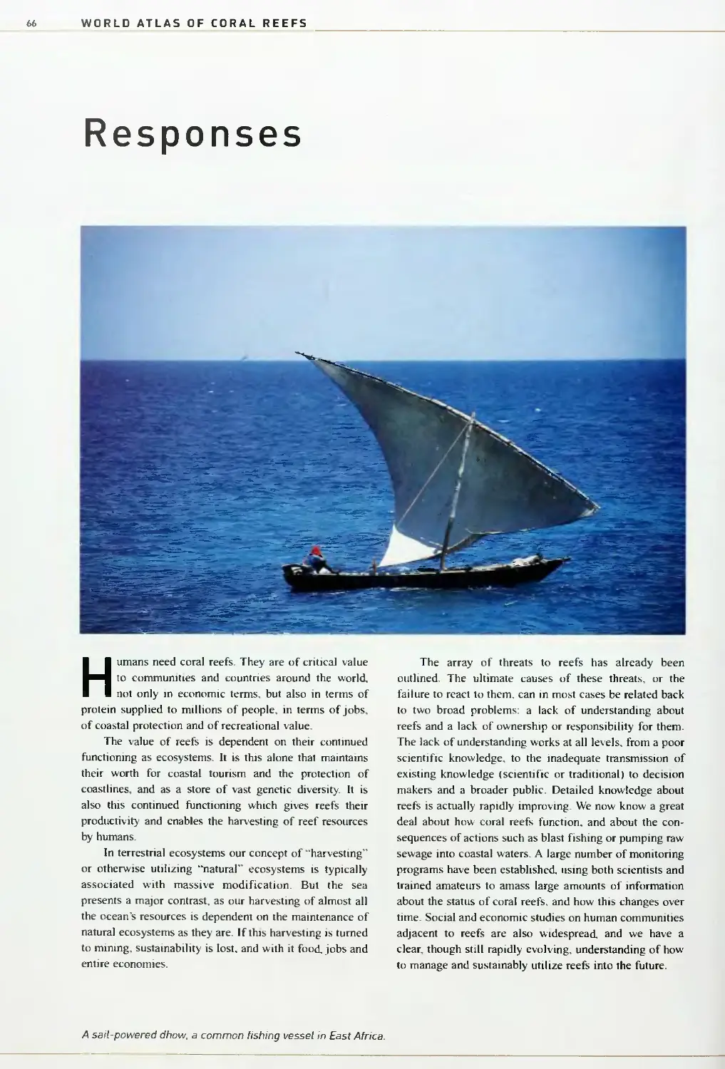
Responses
Chapter 3
Reef Mapping
Reef mapping techniques
Global reef mapping
PART II
The Atlantic and Eastern Pacific
92
12
Chapter 4
Northern Caribbean
95
Florida and the US Gulf of Mexico
97
13
Bermuda
101
Bahamas
103
Turks and Caicos Islands
106
U
15
Chapter 5
19
Western Caribbean
110
27
Mexico
113
29
Belize
Honduras. Nicaragua, Guatemala
117
and El Salvador
121
Ab
Costa Rica and Panama
125
47
Colombia and Ecuador
130
56
Cuba
135
66
Jamaica
139
Cayman Islands
U1
78
Chapter 6
81
Eastern Caribbean and Atlantic
U7
89
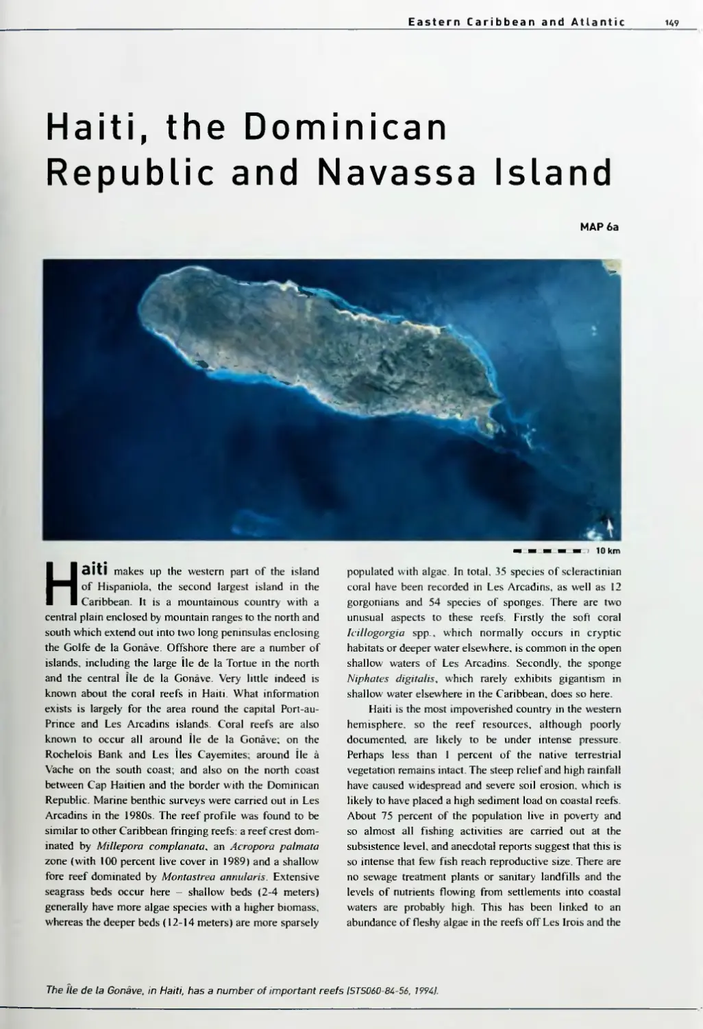
Haiti, the Dominican Republic and
Navassa Island 1^'
Puerto Rico and the Virgin Islands 153
The Lesser Antilles, Trinidad and Tobago 1 58
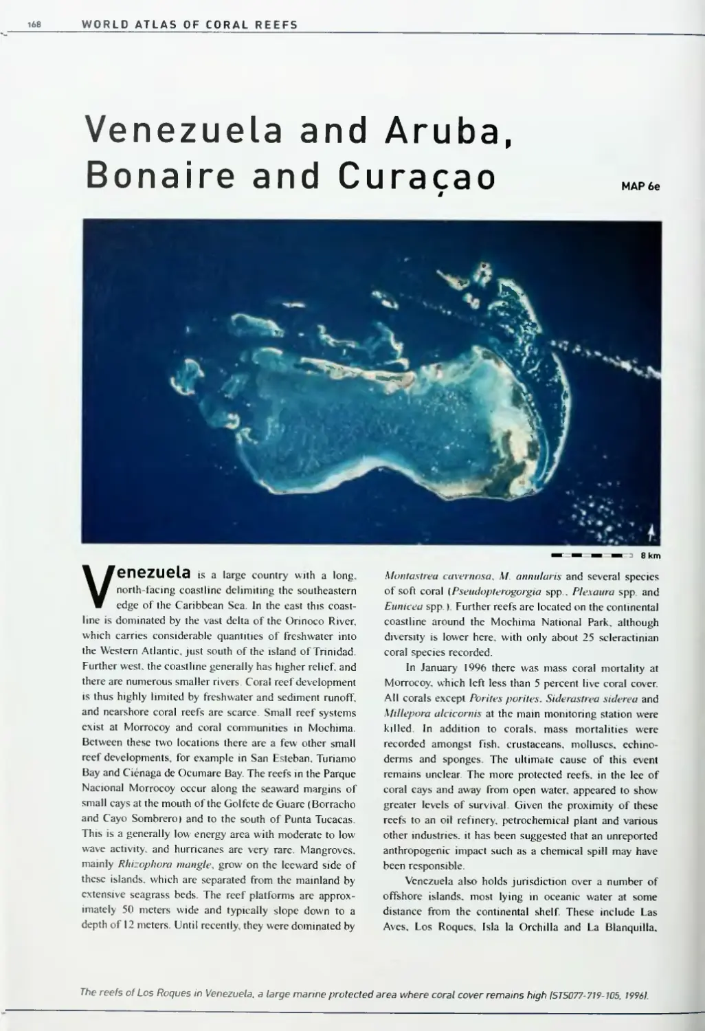
Venezuela and Aruba, Bonaire and Curacao 168
Brazil and West Africa 1 73
WORLD ATLAS OF CORAL REEFS
PART III
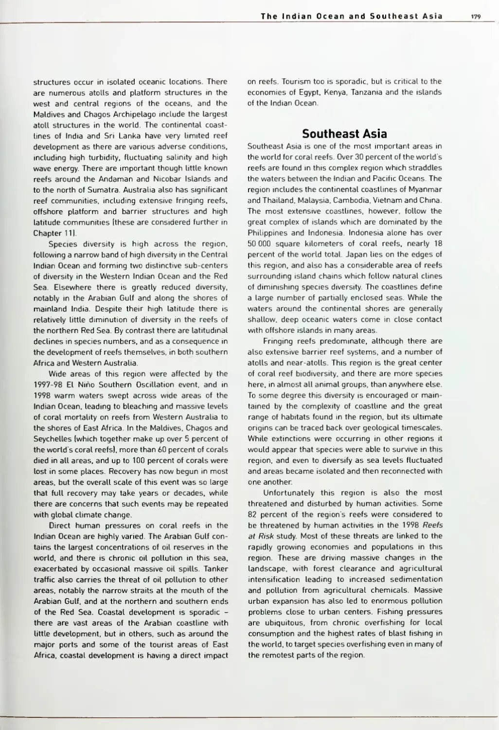
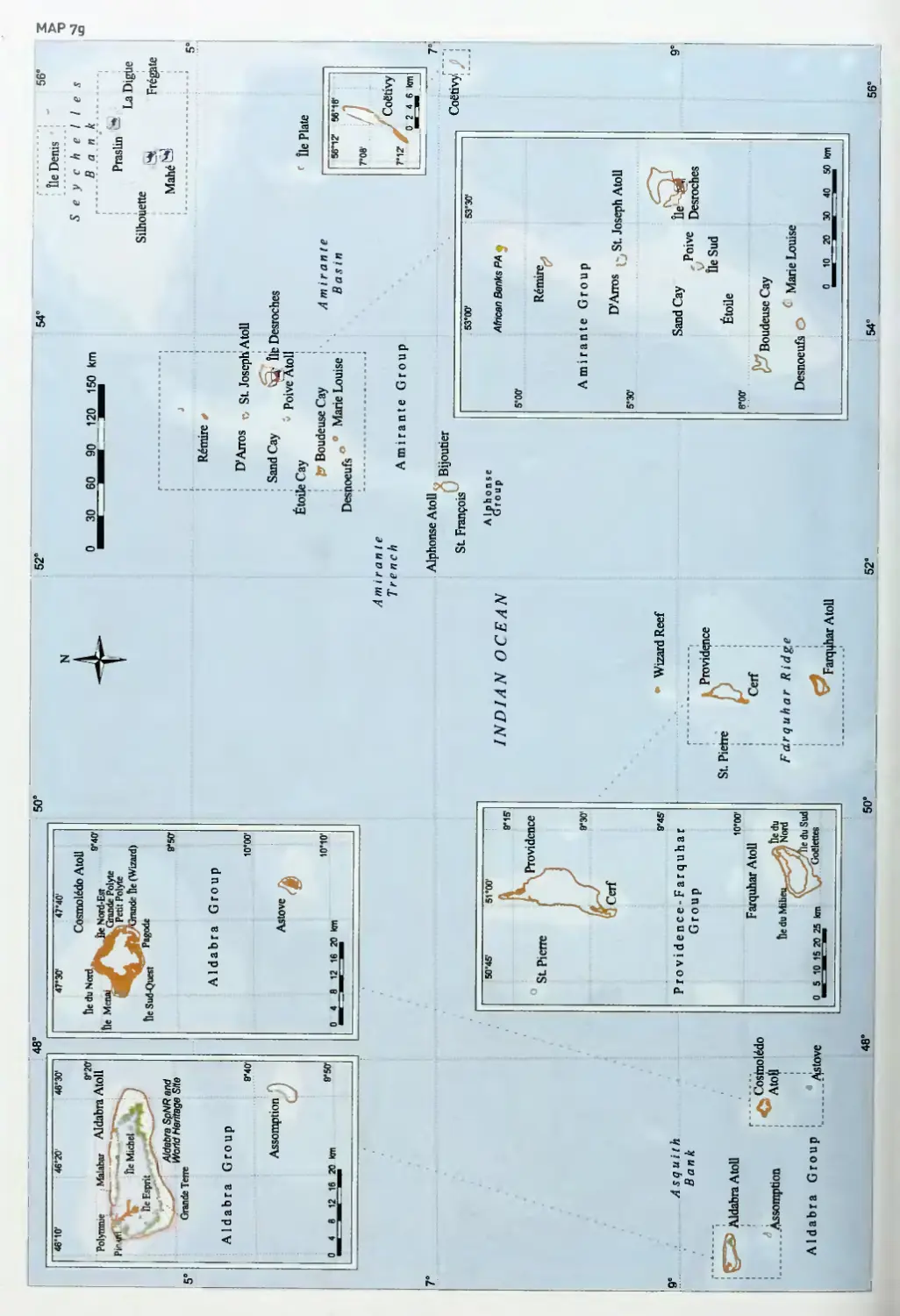
The Indian Ocean and Southeast Asia
178
PART IV
The Pacific Ocean
300
Chapter 7
Western Indian Ocean
Kenya and southern Somalia
Tanzania
Mozambique and South Africa
Madagascar
Mayotte, Comoros and outlying islands
Seychelles
Mauritius and Reunion
Chapter 8
Central Indian Ocean
India. Pakistan and Bangladesh
Sri Lanka
Maldives
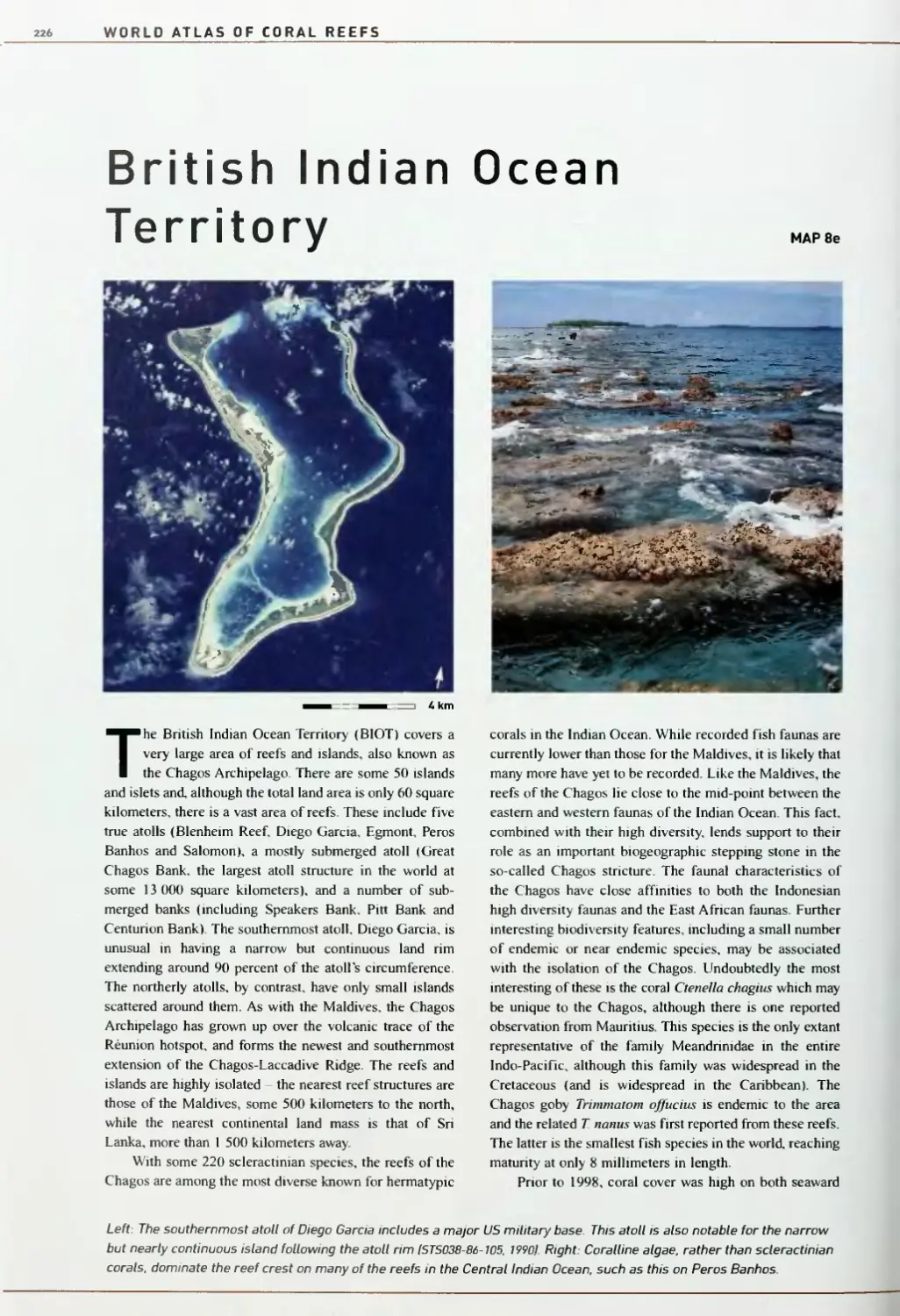
British Indian Ocean Territory
Chapter 9
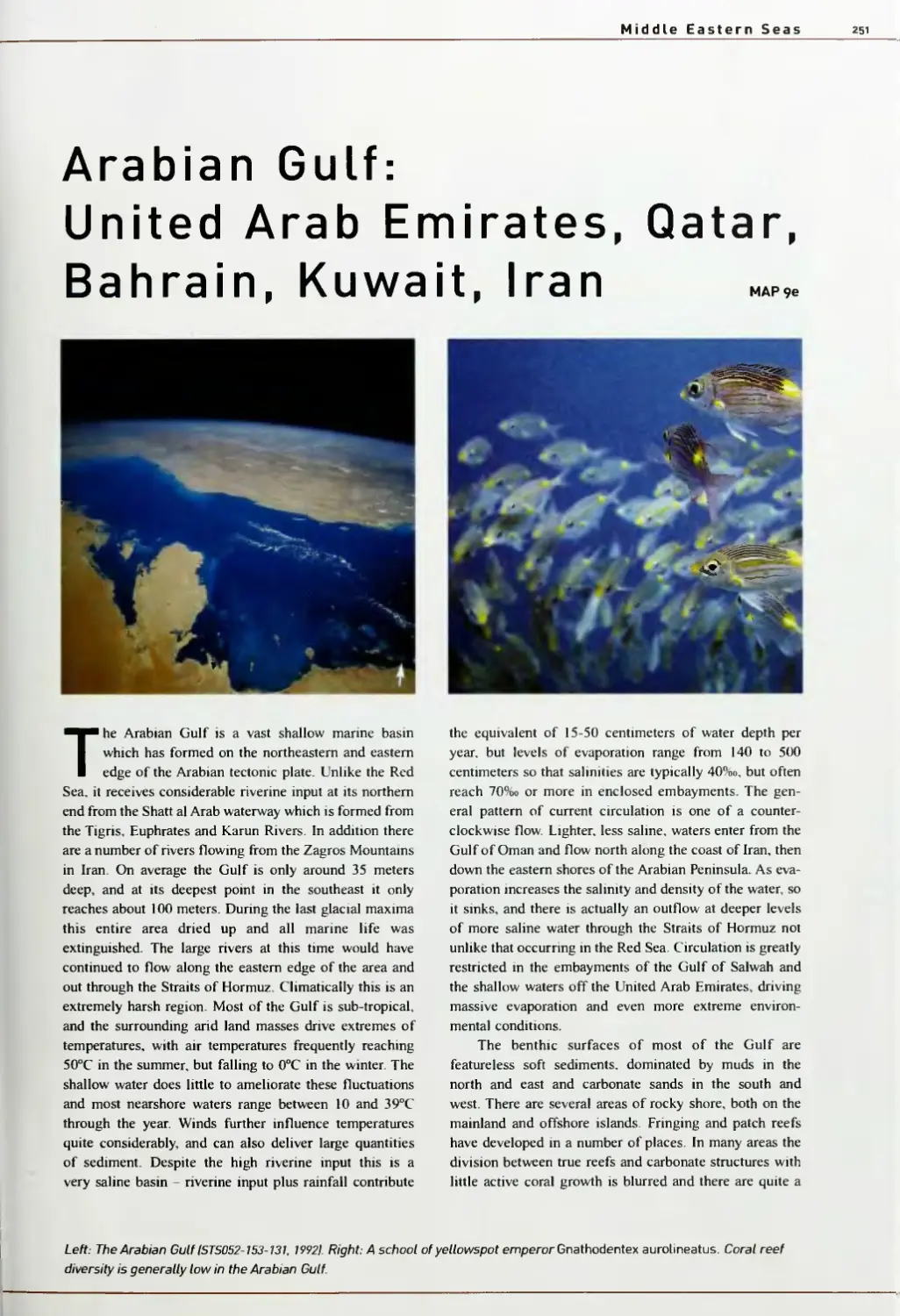
Middle Eastern Seas
Northern Red Sea: Egypt, Israel, Jordan
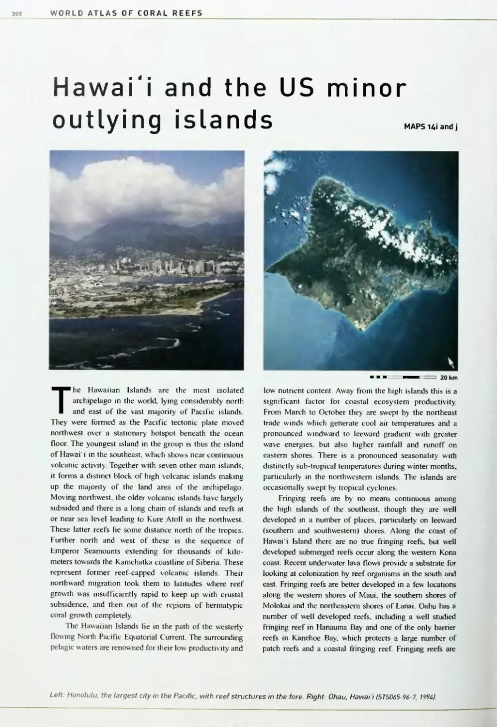
Saudi Arabia
Central Red Sea: Sudan
Southern Red Sea: Eritrea and Yemen
Southern Arabian Region: Yemen, Djibouti,
northern Somalia and Oman
Arabian Gulf: United Arab Emirates,
Qatar, Bahrain, Kuwait, Iran
Chapter 11
180
Australia
302
183
West Australia
305
186
North Australia
309
191
Torres Strait and the
Great Barrier Reef
310
194
The Coral Sea
319
197
High latitude reefs
320
200
205
Chapter 12
Melanesia
Papua New Guinea
323
325
212
Solomon Islands
330
215
New Caledonia
334
219
Vanuatu
338
221
Fiji
342
226
Chapter 13
Micronesia
348
233
Commonwealth of thi
5 Northern
Mariana
235
Islands and Guam
351
2/10
Palau and the Federa
ted States
of
2-13
Micronesia
354
lUk
Marshall Islands
Kiribati and Nauru
360
363
247
251
Chapter 10
Southeast Asia 259
Thailand, Myanmar and Cambodia 261
Malaysia, Singapore and Brunei Darussalam 266
Chapter 14
Polynesia
Tuvalu and Wallls and Futuna
Tokelau, Samoa and American Samoa
Tonga and Niue
Cook Islands
French Polynesia, the Pitcairn Islands
Indonesia
272
and Cllppertor
Philippines
281
Hawaii and the
Spratly Islands, Tung-Sha IDongsha
Qundaol Reefs and the Paracel Islands
287
Vietnam and China
289
Technical notes
Taiwan and Japan
293
Index
369
371
373
377
381
385
392
401
404
Introduction
Introduction
Coral reefs are one of the world's most spectacular
ecosystems. They straddle the tropics and cut a
broad swathe around the globe. They are clearly
visible, even from space, as patterns of dazzling colors
tracing the edges of coastlines and scattering far out
into the oceans. Up close, the magic of coral reefs is
magnified. These ecosystems are packed with the highest
densities of animals to be found anywhere on the planet.
Thronging with life, they rival even the tropical rainforests
in terms of diversity.
From a human perspective coral reefs are not only a
source of wonder and fascination. They also represent a
critical resource for millions of people. For millennia
coastal peoples have relied on coral reefs as a source of
food. The wide strips of coral reefs lining their shores
have also provided protection from the worst onslaughts
of tropical storms. Over the centuries, these same reefs
have actually provided the sand for the beaches and even
the rocks which make up the islands on which so many
people live. In more recent times coral reefs have become
the treasured destination for millions who have sought
peace and rest on tropical shores, or adventure, diving into
the world of the coral reef These same travelers are
providing a new source of income and employment for
some of the world's most impoverished nations. Into the
future, reefs have the capability to provide new resources
for the world's burgeoning populations, most notably with
the development of new pharmaceuticals.
How little we know
It is possible, even today, to pick up the best navigational
charts for certain areas and find quite shocking gaps in
our knowledge. For some parts of the world, the best
information about the location and dimensions of coral
reefs was gathered by Captain James Cook and others in
the 1 8th century. On some of these "modern" charts there
remain dotted lines showing "possible" locations of reefs,
or notes describing reefs as "position unconfirmed".
While sea monsters no longer populate our maps, many of
the gaps where they once sat still remain.
This lack of knowledge is not simply confined to
knowing where the reefs are. Efforts to quantify the total
numbers of species which are found on reefs remain
largely restricted to wild extrapolations and educated
guesses. As many as 100 000 species may have been
named and described from coral reefs, but the total num-
ber inhabiting the world's reefs may be anything between
half and 2 million, perhaps more.
In some ways this lack of knowledge is not
surprising. Many reefs are remote and, as they are far from
regular shipping traffic, efforts to map these areas have
not been prioritized. Without good charts other navigators
remain cautious about sailing in such areas. From an
ecological perspective our knowledge has been further
hampered by the fact that humans are terrestrial, air-
breathing creatures. Early scientists could only peer down
with fascination through the intervening waters which
separated them from the reefs, or haul up dead or dying
samples for inspection. Only in the 1950s did scuba-
diving become a popular and relatively safe activity, and
our scientific knowledge of the ecology of reefs has
almost entirely been amassed over the last 50 years.
The World Atlas of Coral Reefs
This atlas presents a unique compendium of information.
It provides a summary of what we know about the geo-
graphic distribution and status of coral reefs at the start of
the third millennium. Unfortunately, even as we have
begun to gather this information, the reefs themselves
have been changing. The atlas also provides information
on the changes which have already occurred, and on the
human impacts on the coral reefs in every country.
This atlas is primarily an information resource.
Putting such information together at the global level is
more than a summary, however, and provides us with an
entirely new perspective.
The first three chapters provide a global review of the
coral reefs, firstly taking an ecological and geological
perspective, then a human perspective, and finally looking
more specifically at the task of mapping coral reefs. The
main bulk of the book is then focussed towards a region-
by-region review of coral reefs.
The most important resource in any atlas is the maps
themselves. The UNEP World Conservation Monitoring
Centre first commenced its global coral reef mapping
work in 1994 and has now developed the most detailed
global maps of coral reefs in existence. These maps show
the distribution of the vast majority of the world's shallow
coral reefs. Equally important with the maps in this atlas
has been to place the location of coral reefs in a wider
WORLD ATLAS OF CORAL REEFS
context. The maps in this book thus show major natural
features (forests, rivers, topography and bathymetry), but
also significant human factors, including settlements, dive
centers and marine protected areas.
The texts and tables provide information which
enables a more detailed interpretation of the information
provided on the maps, including information which cannot
directly be shown on the maps themselves. For all coun-
tries and territories where there are reefs, basic information
is provided describing the distribution of the reefs and
some ecological features. Human uses and impacts on
coral reefs are fiarther considered, including efforts to
control such impacts or protect coral reefs. Data tables list
all the protected areas with coral reefs, but also provide
directly comparable information describing the countries,
their reefs, and the human impacts on these.
Users of this book can learn about the location and
status of coral reefs around the world. Those traveling
regularly to coral reef areas, for leisure or for work, can use
the World Alias of Coral Reefs to learn about new areas
before they visit, to get a basic grounding in the ecology of
coral reefs, and to consider the issues and challenges facing
reefs in particular areas. Experts from particular locations,
or in particular subjects, can learn about other areas, and
gain useful information about different parts of the world.
A considerable amount of information held within the
pages of this atlas has never been published before.
■ The work includes a new, revised global estimate of the
total area of coral reefs worldwide. In Chapter 1 it is esti-
mated that shallow coral reefs worldwide occupy some
284 300 square kilometers, an area about half the size of
Madagascar. This is less than 1.2 percent of the world's
continental shelf area, and only 0.09 percent of the total
area of the world's oceans. Coral reefs are a scarce, but
critically important resource.
■ An assessment of the area of coral reefs in individual
countries provides an important perspective on the
ownership and responsibilities associated with this critical
heritage. Indonesia is the largest coral reef country in the
world, followed by Australia and the Philippines. Also
high up the list are many small nations in terms of land
area: Papua New Guinea, Fiji, the Maldives, the Marshall
Islands, Solomon Islands, Bahamas and Cuba.
■ Using information from the new taxonomic work
Corals of the World, JEN Veron has provided the very
latest information on coral biodiversity around the world.
National statistics have been calculated for all countries
and clearly illustrate the critical heritage which is
currently being threatened by human activities. The most
diverse region of the world for coral reefs is centered on
the Philippines, Indonesia, Malaysia and Papua New
Guinea, with between 500 and 600 species of coral in each
of these countries. Unfortunately these are also some of
the most threatened coral reefs in the world.
■ Reef tourism is now a major global industry. Visitors
to the Great Barrier Reef increased from I.I million in
1985 to over 10 million in 1995. Scuba diving is probably
the most popular adventure sport in the world and vast
numbers of scuba divers visit coral reefs every year. A
new database has been gathered which gives the location
of dive centers around the world. This contains infor-
mation on over 2 000 dive centers, marked on the maps
throughout this work. They show, quite clearly, that diving
tourism is now ubiquitous, and is located in 91 countries
and states.
■ Marine protected areas are becoming a critical tool for
the protection of coral reefs worldwide. They are being
widely used, not only for conservation, but also to enhance
fish catches, by protecting small stocks of fish which are
able to resupply adjacent areas. There are now some 660
marine protected areas worldwide which incorporate coral
reefs. These include two of the world's largest protected
areas, Australia's Great Barrier Reef and the northwestern
Hawaiian Islands, covering entire large ecosystems.
■ Unfortunately, many protected areas exist on paper
only - they are poorly managed and have little or no sup-
port or enforcement. Equally worrying is that in almost
every single case, protected areas are aimed solely at
controlling the direct impacts of humans on coral reefs.
Fishing and tourist activities may be controlled, but the
more remote sources of threats to reefs, notably pollution
and sedimentation from the adjacent land, continue
unabated. Without a more concerted effort to control all of
the impacts of humans on coral reefs even the best
managed marine protected areas may be managed in vain.
■ The same statistics also point to the important role
which a number of the world's very wealthy nations could
play in protecting the world's coral reefs. Australia,
France, the UK, the USA and even New Zealand hold
jurisdiction or significant influence over coral reefs in
their own waters and in the waters of their overseas
territories and associated states. Together these cover over
one quarter of the world's coral reefs.
■ There are other stories, however, which provide
valuable examples of success. Fisheries reserves in a few
areas are now revitalizing the food supplies and eco-
nomies of local villages, while tourist income is paying
for the wise management of a number of important areas.
It is vital that the messages from these sites are carried as
swiftly as possible to all countries and communities who
depend on coral reefs.
Introduction
Aside from such clear statistics, the pages of this atlas
reveal a startling, recurring tale of degradation and loss.
■ Corals are extremely sensitive to increases in
temperature, exhibiting a stress response known as coral
bleaching. Records of such bleaching have increased
considerably in recent years, and in 1998 a global mass
bleaching event occurred, with devastating mass mortali-
ties of corals in many areas. Recovery is now underway,
but there are very real concerns about the recurrence of
such events with global climate change.
■ In the Caribbean apparently natural damage from
disease and hurricanes has been exacerbated by the
impacts of human activities, and reefs have lost coral
cover and diversity in almost every country, even in many
apparently remote and protected locations.
■ In Southeast Asia burgeoning populations and rising
living standards are placmg untenable pressures on the
coral reefs, and many are succumbing, no longer able to
provide the fish and other resources which have supported
coastal populations for generations.
■ Even the more remote reefs worldwide are not secure.
In the past, remote atolls in the Pacific have been used for
testing nuclear weapons and for dumping waste, and even
today a number are still used for military target practice.
More widespread has been the impact of fisheries. In
many places traditional management and restraint has
enabled sustainable use of fish resources, but such
traditional systems are breaking down in some areas,
while better transport and high prices are driving stocks of
some target species towards complete disappearance, even
in quite remote locations.
The problems facing the world's reefs
Natural changes are a part of any ecosystem, and we are
still at the early stages of understanding the natural
dynamics of coral reefs. However, the 20th century saw
the near exponential growth of human populations,
combined with even more rapid increases in consumer
demands being placed on the planet's limited resources,
and such trends are set to continue through the 21st
century. Humans are thus bringing new pressures to bear
on the worlds coral reefs and driving more profound
changes, more rapidly, than any natural impact has ever
done. Overfishing has become so widespread that there
are few, if any, reefs in the world which are not threatened.
This, combined with such destructive practices as blast
fishing, is shifting the patterns and balances of life in
many reef ecosystems. From onshore a much greater suite
of damaging activities is taking place. Often remote from
reefs, deforestation, urban development and intensive
agriculture are now producing vast quantities of sediments
and pollutants which are pouring into the sea and rapidly
degrading coral reefs in close proximity to many shores.
The impacts of these activities affect not only the
reefs, but also the many millions of coastal peoples who
depend upon them for sustenance and income. In many
areas these changes are so rapid that we are unable to
document the existence of reefs before they are degraded.
We have no idea how much has already gone.
A further specter overshadowing the world of coral
reefs is that of global climate change. It is now universally
accepted that the global climate is changing at an accel-
erated rate as a result of human activities. Coral reefs, it
would appear, are among the most vulnerable ecosystems to
rising sea surface temperatures. Coming on top of the other
threats already mentioned, it seems highly probable that the
predicted rises in sea surface temperatures over the next
century may well cause the total demise of at least some of
these critical, valuable and beautiful ecosystems.
Faint glimmers of hope
As our knowledge and our concern about coral reefs is
increasing, so are the efforts to redress the problems.
Overfishing is a worldwide problem, and its most dam-
aging impact is on the fishing communities themselves.
Thankfully, examples are now cropping up around the globe
of successful management efforts which can remedy the
problem. By setting aside small areas as "no-take" zones,
local communities are finding that there are enormous
benefits. Fish stocks build up in these zones and spill over
into the surrounding area such that the overall yield of fish
fi-om the wider area is increased. Everyone benefits.
Tourism has caused considerable damage, through the
unplanned coastal development and pollution which are so
often linked to it. The sewage systems of many hotels empty
directly into the waters where the guests swim, and the
damage to reefs can be considerable. Increasing awareness,
however, is leading to better controls on development and
major efforts to improve sewage treatment. As such
measures develop, tourism can become a force for good,
giving an added value to reefs in the eyes of the local
communities, and often providing a direct income, through
park fees, for the management of marine protected areas.
Most importantly, our increasing understanding of
the interactions between humans and reefs, and between
terrestrial activities and their downstream impacts in the
coastal zone, are allowing for the development of integrated
planning. We are aware of the problems, and have the
solutions. The challenge is to apply them.
WORLD ATLAS OF CORAL REEFS
Essential information
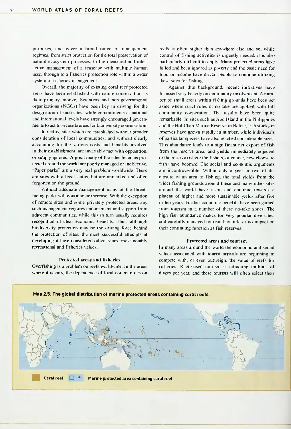
Key to all maps in Chapters A to U, labeled a-j
Coral reef
Mangrove
Dive center
Population center
International boundary
River
Water body
Land
Forest
National marine protected area
National marine protected area (boundary unknown!
International protected area
International protected area [boundary unknown!
Bathymetry
0-200 meters
200-2 000 meters
> 2 000 meters
Space Shuttle photographs
^^^m^^^^^HQ Approximate North arrow
I — ^ ^ I 7 km Approximate scale
ISTS062-84-70. 19941 NASA archive number
Throughout this publication the use of na indicates that no
relevant information is available.
For technical notes regarding the text, maps and data tables, see page A01 .
Unde rstanding Coral Reefs 13
Parti
Understanding Coral Reefs
WORLD ATLAS OF CORAL REEFS
Chapter 1
The World of Coral Reefs
Coral reefs are among the most diverse and
complex of all ecosystems; tfiey are among
the most heavily utilized and economically
valuable to humankind; and they are also
among the most beautiful and fascinating.
In order to understand what lies behind such acco-
lades It Is Important to appreciate exactly what coral
reefs are, how they are formed and where they are
found. Building on such a foundation it is also valu-
able to develop a basic understanding of some of the
organisms that make up the complexity of life on coral
reefs, and what role they play In maintaining these
ecosystems. Such knowledge provides the basis for
a wider understanding of the Interactions of humans
and reefs. It Is also critical for understanding the
changes that are now occurring on coral reefs, and for
responding to such changes.
This chapter offers a simple definition and des-
cription of coral reefs. It goes on to orovlde an overview
of their distribution, and of the organisms that make
them up. It considers the elements determining these
distribution patterns, from factors of geological history
to present day limiting processes and the very impor-
tant role of ocean currents. The chapter also looks
briefly into some of the patterns of biodiversity which
are observed at finer resolutions, patterns which are
observed between neighboring reefs, and zonation
patterns across individual reefs. Finally, the chapter
provides an overview of the main organisms which
make up the patterns of life on coral reefs.
Above, left: Midway Islands ISTS055-82-63. 19931. Above, right: The edge of the reef, with spur and groove formations. Great
Barrier Reef Below, left: Shallow waters of an atoll lagoon. Below, right: The intricate branches of an Acropora coral.
The World of Coral Reefs
Defining coral reefs
For all those who have seen one, a coral reef is
relatively simple to describe. From land or from the
air, reefs are usually clearly visible, marked by a
complex patterning of bright colors. These arrays of blues,
turquoises and greens delimit a diverse and complex
physical structure coming close to the ocean surface. The
shallowest points are frequently shown by the brilliant
white of breaking surf and may even briefly become
dry land during the lowest tides. From underwater the
complexity is still more clearly shown - reefs are typified
by the presence of large stony corals growing in profusion
and by an often bewildering array of species growing or
moving among them. Moving across a reef patterns or
zones become apparent, each dominated by different
organisms, depending on factors such as depth, shelter
and water movements.
Although simplistic, such descriptions incorporate
the key elements of a more thorough scientific definition
of a coral reef Coral reefs are shallow marine habitats,
defined both by a physical structure and by the organisms
found on them.
Corals themselves are very simple organisms. They are
found in all the worlds oceans, at all depths. Although
described in more detail later in this chapter, typically they
have a very small cylindrical body, topped with a ring of
tentacles which are used to capture food from the sur-
rounding waters. A large number of corals have developed
the ability to live in colonies and to build up a communal
skeleton. Among these are many species which lay down a
stony skeleton of calcium carbonate. These corals are
known as hermatypic or reef-building corals. They are
almost entirely confined to areas of warm, shallow water,
and it is their skeletons, essentially built of limestone,
which are critical to the formation of coral reefs.
Even in ideal conditions, these hermatypic corals are
slow growing. Some massive corals, which typically grow
as large dome-shaped structures, may build up a skeleton
at rates of just a few millimeters per year. The faster
growing tips of branching corals may extend at rates of
150 millimeters per year or more.
Over centuries or millennia the active growth of these
corals (alongside other organisms such as coralline algae,
which also lay down calcium carbonate skeletons) leads to
the building up of vast carbonate structures. The process
is not simple, and numerous additional factors come into
play. Storms frequent many areas of tropical coastlines
and the waves they produce can, quite literally, pound a
reef to rubble in a few hours. Over longer time scales,
corals are eroded by countless organisms. Some fish bite
large chunks out of them, digesting the coral tissues and
algae on their surface. Unseen but equally important is a
great diversity of bio-eroding organisms that burrow into
or chemically dissolve the coral rock, weakening and
destroying its structure. Sand and rubble from these
apparently destructive activities often fill the interstices of
the reef while certain algae and other corals may then
bind or overgrow such loose materials, cementing them
together with more calcium carbonate to form a yet more
solid structure.
In this way a coral reef is built. Only a tiny fraction of
the growth of individual corals is converted into upwards
development of a reef structure, and so their formation
takes place over geological time scales. The most rapid
periods of reef "growth" have shown upwards accu-
mulation of reef structures reaching 9-15 meters in 1 000
years in some areas, but much lower figures are probably
-■
■r-i
^:^
"i
V.
^^s^^l
Above: Individual polyps of the great star coral Montastrea cavernosa, clearly showing the cylindrical body, with a ring of
tentacles. Below: The growth of numerous corals builds up the massive physical structure of an Indian Ocean reef.
WORLD ATLAS OF CORAL REEFS
more normal. In fact the majority of reef structures that
exist today are not the result of continuous growth, but of
pulses of growth interspersed with quiescent periods, or
even periods of erosion, when the reefs might be defined
as fossil or non-living reefs. Sea levels in the oceans have
varied dramatically, particularly during the recent ice
ages, and many reefs have intermittently become dry land,
or have been flooded by waters too deep to allow corals to
grow. Between these extremes, however, some of these
fossil structures become recolonized by corals and reef
development recommences.
Over shorter time scales, the division between an
actively growing coral reef and a fossil reef is, in many
areas, unclear No reef is in a constant state of growth.
During major tropical storm events, all reefs undergo
losses in coral cover and often considerable erosion of
their physical structure. Over years or decades, the extent
of actively growing coral cover also varies considerably.
Recently observed events, including coral disease, coral
bleaching, outbreaks of the coral-feeding crown-of-thorns
starfish, or the die-off of important grazers such as the
long-spined sea urchin (see page 61), have all produced
considerable losses of live coral cover to some reefs.
Recovery from such events points to a natural resilience,
but also shows that any understanding of a "reef" measured
from only one particular moment in time will be limited.
Takmg such points into consideration, a coral reef can
thus be more rigorously defined as a physical structure
which has been built up, and continues to grow over
decadal time scales, as a result of the accumulation of
calcium carbonate laid down by hermatypic corals and
other organisms. The manner in which such structures
develop has led to the recognition of a number of types of
reef, while there are also many other communities which,
while not as obviously covered by these definitions, are
clearly related and equally important.
Types of reef
Corals can only grow in warm, well lit waters and require
a solid surface on which to settle. These factors restrict the
initial appearance of hermatypic corals to shallow rocky
substrates in the tropics. As corals proliferate, their
skeletons provide a solid substrate for the appearance and
settlement of more corals and other organisms. The
upward growth of a physical reef structure can also allow
corals to continue to grow in shallow well lit waters, even
if the basement on which they are growing subsides or sea
levels rise.
Fringing reefs are perhaps the simplest structures to
understand. These develop from the simple upward growth
of a calcium carbonate platform from a shelving coastline.
Because growth is most rapid and prolific in shallow
water the corals quickly grow to the surface and produce
a shallow platform which is usually around the level of the
lowest tides. Further offshore growth is slower, but the
typical structure of a mature fringing reef includes a
shallow platform out to a sharply defined edge, the reef
crest, beyond which there is a steeply shelving reef front
dropping down to the sea floor.
Barrier reefs are usually older structures rising up
from a deeper base at some distance from the shore, with
a lagoon separating them from the coast. Some have
their origins as fringing reefs on shelving coastlines, but
develop when the coastline on which they are growing
subsides or is flooded by rising sea levels. Under these
conditions the fringing reef continues to grow upwards,
but deeper waters fill in a lagoon between this structure
and the coastline. In other cases barrier reefs may have
simply developed in offshore locations, but still remain
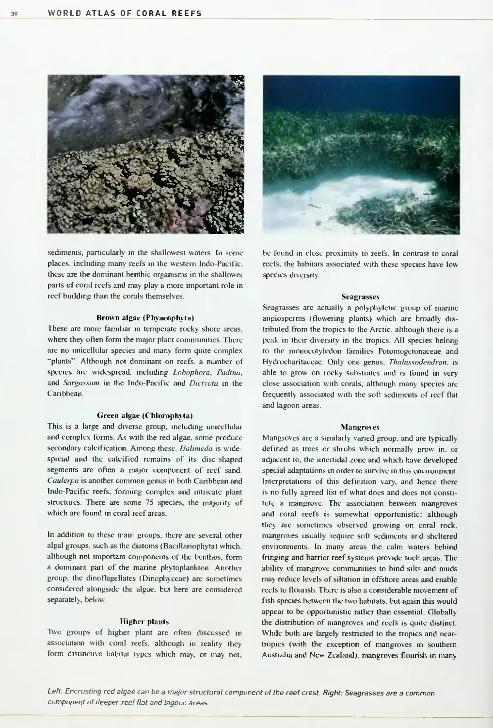
separated from the coast by a lagoon.
Atolls are unique reef formations, broadly circular,
and enclosing a wide lagoon. They are typically found
in oceanic locations, away from the continental shelf
Figure 1.1: The main types of coral reef structure
Barrier
reel
Bank or
platform
reef
The World of Coral Reefs
Darwin was the first to correctly understand their origin.
They initially form as fringing reefs around isolated
usually volcanic, islands. Such islands then subside, but
the reefs continue to grow, first forming a barrier around
the sinking island, but then, as the island disappears
beneath the surface, forming a single ring of coral. The
depths of coral limestone which may accrue on these
structures are considerable - drilling in the Marshall
Islands has revealed reef deposits up to 1.4 kilometers in
depth, dating back over 50 million years.
Bank or platform reefs are simple physical structures
with a variety of origins. They are essentially reefs with
no obvious link to a coastline, but without the clear struc-
ture of a barrier reef or atoll. In some cases they may have
similar origins to either of the latter, but do not hold back
or encircle a lagoon, in other cases they may have simply
grown up over natural rises in the coastal shelf Larger or
slightly submerged reef structures of this type are also
sometimes referred to as shoals.
Other types of reef and coral communities
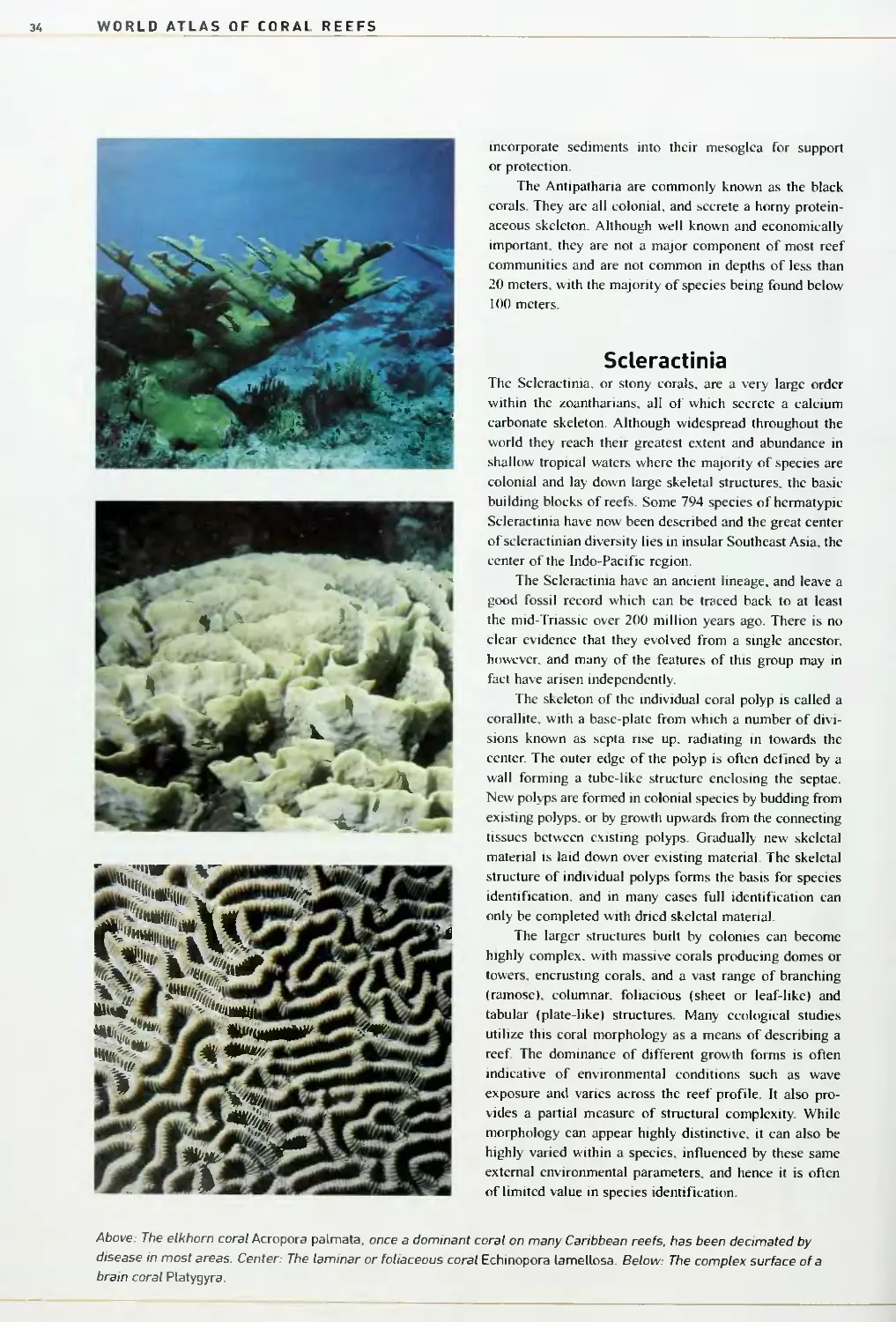
These reef types can be clearly illustrated (Figure 1.1).
However, the reality often reveals many other structures
which do not conform quite so easily to strict definitions.
Near-atolls are described in a few areas where there is a
tiny remnant of the original high island in the center of an
atoll ring. There are also a considerable number of atoll-
like platform reefs which may not have the true geological
origin of an atoll (around a subsiding volcanic island), but
where the surface structure is almost exactly that of an
atoll. There are also a number of structures which lie
offshore in the location of a true barrier reef, but which
may not quite conform to the definition or geological
origin of a barrier reef Bank barriers are commonly
described in parts of the Caribbean where small banks lie
at some distance offshore and sometimes do not rise all
Figure 1 .2: The development of an atoll, based on
Darwin's original theory
A volcanic island is colonized by corals and becomes
surrounded by a fringing reef.
The island itself subsides, the corals continue to grow
and a barrier reef is formed.
The island is lost, but coral maintains upward
growth and a ring-shaped atoll is formed.
Table 1.1: Estimates of global reef area calculated from the reef maps
Region
Area (km^)
% of world total
Atlantic and Caribbean
21 600
7.6
Caribbean
20 000
7.0
Atlantic
1 600
0.6
Indo-Pacific
261 200
91.9
Red Sea and Gulf of Aden
llAOO
6.1
Arabian Gulf and Arabian Sea
/,200
1.5
Indian Ocean
32 000
11.3
Southeast Asia
91 700
32.3
Pacific
115 900
40.8
Eastern Pacific
1 600
0.6
Total
ZBi 300
Figures are rounded to the nearest 100 square
kilometers, and percentage figures to one decimal
place. National level statistics are provided in the
regional accounts later in this book. In order to avoid
the problems associated with using maps prepared
at multiple scales, such calculations are made by
first simplifying the global coverage dov^^n to a 1
kilometer grid, each grid cell being simply marked as
reef or non-reef. Reef area is then calculated as the
total of 1 square kilometer cells with reef. Although
this method exaggerates the total area from that
actually shown on the maps, this can be justified on
the grounds that the maps only show reef flat to reef
crest areas, while the true reefs extend beyond these
areas Isee also Chapter 31.
WORLD ATLAS OF CORAL REEFS
the way to the sea surface. The long offshore reef tracts of
Florida, Cuba and elsewhere rival many true barrier reefs
in length, but are frequently not regarded as true barrier
reefs because they are only separated from the mainland
by a very shallow lagoon, or because they are not located
on the edge of the continental shelf. Small physical
structures, often lying within the wider formation of a
barrier or atoll lagoon, are often referred to as patch reefs.
Perhaps more importantly, there are significant areas
around the world where there are coral communities
which perform the same ecological function as coral reefs,
but lack a clear physical structure. These include recent
formations where there may be a thin veneer of live coral,
or they may be physical reefs, but not yet mature or clearly
visible. For clarity such structures are frequently referred to
as coral communities, submerged reefs, or sub-surface reefs.
Global distribution
Charles Darwin was probably the first person to prepare
a global map of coral reefs. His and other efforts are
described in Chapter 3. Coral reefs are restricted to a
broad swathe, roughly confined to the tropics, and circling
most of the globe (Map I.I). Within this range they are
far from evenly distributed, with large areas confmed to
remote island regions and offshore areas far from major
land masses. Further investigation shows that coral reefs
are largely absent from the Central Atlantic and the shores
of West Africa, they are highly restricted along the western
(Pacific) shores of the Americas, and are also restricted
along the coastline of South Asia from Pakistan to
Bangladesh.
Using the maps shown in this publication it is
possible to estimate the total area of coral reefs in the
world. Although there are clear limitations to such
estimates, these figures are clearly valuable for getting an
overall perspective on the area of coral reefs in the world,
and in allowing for regional comparisons. There are an
estimated 284 300 square kilometers of coral reefs
worldwide'. This figure represents only 0.089 percent of
the world's oceans and less than 1.2 percent of the world's
continental shelf area. Thus, at the global scale, coral reefs
are a rare habitat. Further analysis clearly shows that the
great majority of coral reefs are found in the region known
as the Indo-Pacific, which stretches from the Red Sea to
the Central Pacific. Less than 8 percent of the world's
reefs are found in the Caribbean and Atlantic.
Zooming in to these maps, new patterns emerge at
finer resolutions. Reefs are often limited in their develop-
ment in the nearshore waters of large continental land
masses, although barrier structures are widespread in such
places. They are poorly developed close to large river
mouths. In contrast, they are particularly well developed
around islands and along the coastlines of drier con-
tinental areas.
In order to understand these patterns of reef
distribution it is necessary to look at the organisms which
make up the coral reef ecosystem. The factors impinging
on their evolution, dispersion, and survival are the same
factors which have created the patterns in coral reef
distribution that we see today.
1, The reef area figures used tfiroughout this work are based on a new
calculation, and replace the early estimate provided by Spalding and Grenfell
119971 of 255 000 square kilometers. It is likely, as mapping work continues,
that such figures will continue to be refined and improved. This may lead to
further upwards adjustment of the global total, although in some areas
there is also likely to be some reduction of figures as maps are improved.
Thus It seems unlikely that a final" figure would exceed 300 000 square
kilometers.
Map 1.1: The coral reefs of the world
W:-^ ,."..-»?;;■%
-^>^
r-l^i'
30
20
. 10
—
10
20
30
Distribution of scleractlnian corals
The World of Coral Reefs
Patterns of diversity
Observations of life on coral reefs reveal a number
of striking patterns in the distribution of species.
At the global level, few species are ubiquitous.
Some may be widespread across one or even two ocean
basins, but many others are restricted to certain oceans or
particular seas.
As a larger picture is built up through looking at
many species, certain patterns emerge. Some regions are
highly distinctive with large numbers of endemic species,
found nowhere else. The total diversity of species is also
uneven, with centers of particularly high diversity, and
with clear gradients in diversity mirroring environmental
gradients.
When looking at finer resolutions, new patterns
emerge. Certain species appear to predominate in near
continental reefs, while others are found on oceanic reefs.
Closer still, and the position on the continental shelf, or
that relative to the prevailing wind or currents, appears to
hold sway in determining the species composition. At the
scale of tens or hundreds of meters, patterns of zonation
are observed across individual reefs, with species adapted
to different depths, exposure, water circulation and so on.
Finally, at the scale of individual points or quadrats,
the pattern of which species are found where seems to
disappear in a random noise. Even here, however, the
factors driving the settlement and survival of individuals
may be far from chaotic, but driven by highly complex
interactions, both in the immediate sense and over the life
history of the individual.
Patterns at the global scale
Corals are clearly the most important organisms when
it comes to understanding the factors that drive the
distribution of coral reefs. The majority of reef-building
corals fall within the group known as Scleractinia. They
have been the subject of continuing studies by biologists
and taxonomists for many years, and a considerable
amount is now known about their distribution and about
the factors which influence it. Some 794 species of
sclcractinian coral are considered to be reef builders, and
Map 1.2 shows a plot of their distribution, highlighting
the patterns of varying diversity. A number of points can
be observed:
■ Corals, like the reefs they build, are restricted to a
narrow band of low latitudes, with diversity diminishing
fairly rapidly along latitudinal clines.
■ There are two distinctive regions of coral distribution,
one centered around the Wider Caribbean (the Atlantic),
the other reaching from East Africa and the Red Sea to the
Central Pacific (the Indo-Pacific).
■ Diversity is far lower in the Atlantic than in the Indo-
Pacific.
■ Coral diversity is at its highest around insular
Southeast Asia.
■ Coral diversity and reef development are very restricted
along the western shores of the Americas and West Africa.
Although only relating to corals, these patterns are
reflected in most other groups found in tropical coastal
Map 1.2: Patterns of diversity in reef-building scleractinian corals
^^■S:
*■ ""'^^^^^^^^^^^^^B Number of species
<50 50 100 200 300 400 500
-^-
WORLD ATLAS OF CORAL REEFS
waters, as shown by the statistics in Table 1.2. These and
other patterns are derived from a complex interaction of
historical and contemporary factors. For some groups, the
parallel with coral diversity patterns may reflect direct
ecological associations between them. However, for a
number of others, it may be the same external factors
which have actually driven the change. A number of these
factors are briefly laid out below.
The influence of temperature
To a large extent, both scleractinian corals and the reefs
they build are restricted to a latitudinal band between
30°N and 30°S. This general observation is entirely related
to the decreasing temperatures which generally follow
increasing latitude. Most reef corals cannot survive in
temperatures much below 16-18°C for even a few weeks.
In conditions of extreme cold, corals can die within a
matter of hours or days, while under slightly less extreme
conditions, their growth rates are reduced. There is some
evidence that overgrowth by algae rather than the direct
influence of cold water may restrict coral development m
some high latitude areas.
High temperatures are also inimical to coral growth.
Extreme high temperatures drive the phenomenon known
as "coral bleaching", during which the corals expel their
symbiotic algae (see Chapter 2). Aside from human-
induced climate change, it has been suggested that
occasional high temperatures associated with El Niiio
events may be at least a partial explanation for the highly
limited reef development which is observed, for example,
along the western shores of the Americas.
The role of currents
While temperature influences can be broadly equated with
latitude, ocean currents can disrupt these simple patterns.
In a few areas of the world, major warm currents flow all
year round from the tropics into higher latitudes. These
have allowed the development of reefs quite beyond their
normal limits. Notable are the Leeuwin Current in
Western Australia; the East Australian Current; the
Kuroshio Current in Japan; and the Gulf Stream warming
the isolated oceanic reefs of Bermuda. In a similar way,
cold waters prevent reef growth. Cold water upwellings
along the coastlines of northeastern Somalia and southern
Arabia are perhaps the clearest example, while the
extremely limited development of reefs and coral com-
munities along the western coastlines of the Americas
and West Africa may also be influenced by cold water
upwellings.
Another role of currents is in the transport of larvae
to areas of reef The establishment of corals in new areas
is dependent on the transport of coral larvae in ocean
Left, above: A smalt coral cay on the reef flat of an atoll, Salomon Atoll. Chagos Archipelago. Left, below. The Beqa
Barrier Reef in Fiji. Right: Fringing reefs, near Suva, Fiji.
The World of Coral Reefs
Table 1.2: Regional patte
the clear pattern of max
rns of species
mum diversity
diversity in
in the Indo
coral reefs
Pacific reg
and related ecosystems:
on is shovim in all species groups
Taxonomic group
ndo-West Pacific
Eastern Pacific
Western Atlantic
Eastern Atlantic
Scleractinian corals'
719
34
62
Alcyonarian corals
690+
6
Sponges (general
2U
117
Gastropods;
Cypraeidae
178
24
6
9
Conus
316
30
57
22
Bivalves
2 000
564
378
427
Crustaceans:
Stomatopods
249
50
77
30
Caridean shrimps
91
28
41*
Echinoderms
1 200
208
148
Fish
iOOO
650
1400
450
Butterflytish and angelfish^
175
8
15
7
Seagrasses'
3A
7
9
2
Mangroves'
59
13
11
7
• All Atlantic
Source; Paulay 119971 except:
l.Veron 120001.
2. Allen el al 119991
3. WCMC database - figures include species with warm temperate distribu
^. Spalding et all 19971.
ions.
currents. Unfavorable currents may prevent the coloni-
zation of areas by new species, notably in the remote reef
regions of Brazil and the Eastern Pacific. The mechanisms,
and the importance of this transport, are further con-
sidered on page 23.
Changing patterns over geological time scales
Separate faunas - Atlantic and Indo-Pacific. Many of
the global patterns in reef and coral development can be
explained by looking at the tectonic and climatic history
of reefs. Scleractinian corals evolved during the Triassic
(205-250 million years ago) and quickly developed a
circum-global distribution, only restricted by areas of
suitably shallow substrate. As the continents broke up and
shifted, the global connection of tropical oceans became
more restricted. With the closure of the Tethys Sea, the
waters of the Indian Ocean and Western Pacific were
separated from those of the Atlantic and far Eastern
Pacific, and the coral reef communities in each began to
develop distinctive characteristics.
Low diversity in the Atlantic. The closure of the
isthmus of Panama divided the "western" fauna into
two. This entire region was then subjected to massive
extinctions during the Pliocene/Pleistocene glaciations,
removing many of the species which were once commonly
found on all coral reefs. The Atlantic corals now share
only seven genera with the Indo-Pacific. Even as
environmental conditions improved, continued eustatic
disruption may have prevented subsequent re-expansion
and diversification of the coral reef fauna, and there has
been little time since the end of these glaciations for any
further species radiation. The result today is clearly shown
in the far lower species diversity in the Atlantic reefs. For
scleractinian corals the Atlantic only holds about one tenth
the number of species as the Indo-Pacific, while similar
patterns hold for almost all other species groups, with
between one third and one tenth of the diversity on
Atlantic reefs as compared to Indo-Pacific reefs.
High diversity in the Indo-Pacific. The same period
of extinctions was not so extreme in the "eastern fauna",
the area now known as the Indo-Pacific. Right across
the region there are large areas of shallow coastal shelf
spanning considerable latitudinal ranges. Over these areas
there were more locations or refuges offering opportu-
nities for survival of species during periods of environ-
mental adversity. Species diversity remains high across
much of this region, although there is a clearer decline in
diversity moving east across the Central Pacific.
The Southeast Asian center of diversity. Quite apart
from the generally high diversity recorded across the Indo-
Pacific, there is an area of outstanding diversity centered on
a triangle encompassing the Philippines and central and
WORLD ATLAS OF CORAL REEFS
eastern Indonesia. Species numbers here outstrip any region
of the world, and species counts from individual bays or
islands typically outstrip total species counts from the
entire Caribbean. Some of this great diversity may in fact
be linked to the same period of glaciations which caused
destruction elsewhere. This region is believed to have
maintained somewhat benign conditions during this time,
allowing the survival of many species. Additionally, during
certain periods, species may only have survived in relict
populations restricted to small refugia. Their isolation,
exacerbated by changing sea levels, may have allowed the
independent evolution of populations and the formation
of new species. These would have repopulated the wider
region as conditions ameliorated. Further species may have
accumulated here from outside the region, driven by
patterns of ocean currents flowing westwards from the
islands of the Pacific Ocean.
A number of other historical and contemporary
factors are responsible for driving regional patterns in
biodiversity, notably the low diversity observed in the
Eastern Pacific. Brazilian and West African faunas, and
the sustained high diversity in the Red Sea and low
diversity in the Arabian Gulf These are considered more
fully in the regional chapters.
Patterns at finer scales
Moving in to study reef distribution at finer resolutions,
the discontinuous nature of coral reefs within countries or
along particular coastlines is highly apparent. Corals, and
the reefs they form, are highly sensitive to factors such
as salinity, sediments and nutrients. Where conditions are
inappropriate they do not occur More importantly in
recent times, where conditions change, the corals, and the
reefs themselves, may die.
Sediments and sedimentation
The initial growth of a coral is dependent on a larval animal
finding the right substrate on which to settle. Corals cannot
grow on fine muds or shifting sediments, and such
sediments are a common feature along many of the world's
coastlines. Where corals cannot settle and grow, reefs do
not form. This is at least part of the e.xplanation for the
absence of reefs close to large river mouths and along other
stretches of sediment-laden coastlines. Another influence of
sediments is that of turbidity - in areas with large amounts
of suspended sediments in the water column, the loss of
light further reduces or prevents coral growth.
Once established, corals can cope with limited
amounts of sediments settling upon them from the waters
above, actively removing sediments which smother their
tissues and block out the light. Similarly, once a reef is
formed it is often able to maintain a presence in areas of
otherwise shifting sediments. The reef structure lifts itself
above the sediments, and provides the hard substrate on
which new corals can grow. Reefs can also reduce the
influence of currents and waves which, in some areas,
are responsible for resuspending sediments that might
otherwise smother corals.
Where conditions of sediments and turbidity change
considerably this can lead to the rapid demise of corals
and the death of reefs. There is an energetic cost to a coral
in removing sediments which settle upon it. while the loss
of light associated with increasing turbidity greatly
reduces a coral's chances of survival.
Salinity
Corals are wholly marine organisms, unable to grow in
freshwater It is sometimes quite hard to distinguish the
effects of freshwater from the influence of the sediments,
typically also carried by streams and rivers. However, the
absence of corals from wide areas associated with major
rivers is at least in part related to the low salinities in
these areas.
Nutrients
The considerable biomass and wealth of diversity observed
on coral reefs around the world has led to a common
misconception among non-specialists that reefs may be
dependent on considerable inputs of nutrients. In fact reefs
are highly efficient at nutrient recycling, and are wide-
spread in some of the most nutrient-poor parts of the
oceans. Where nutrient levels are higher, often close to
coastlines or areas of upwelling. reefs still survive, but in
very high nutrient situations other opportunistic species
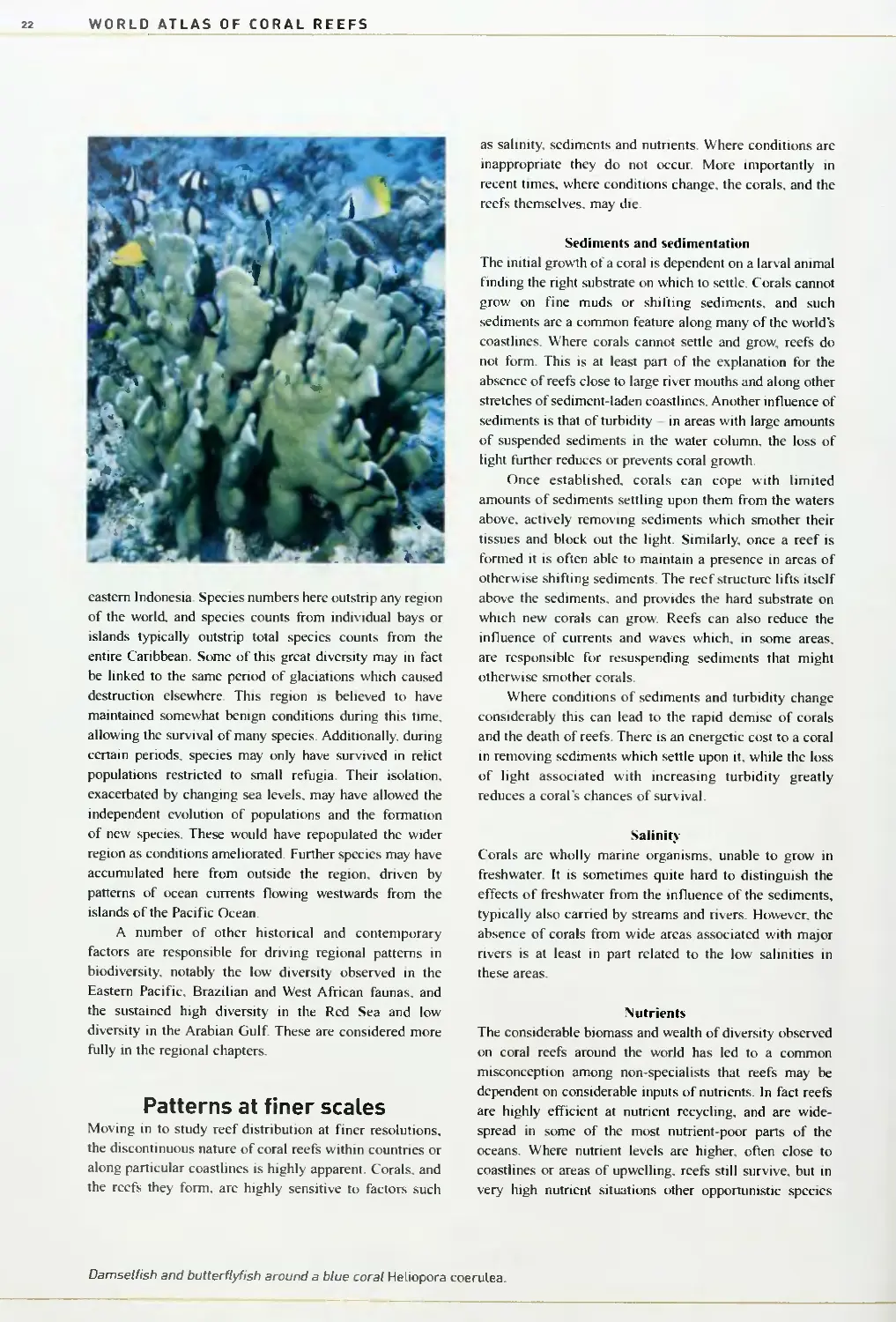
Damsetfish and butterflyfish around a blue coral Heliopora coerulea.
The World of Coral Reefs
23
Movements between reefs
One critical issue when it comes to understanding
the establishment of patterns in species distribution
is the movement of individuals betvi/een localities.
Reefs in general are ecological islands, typically
surrounded by non-reef areas and often separated
from one another by tens or hundreds of kilometers.
Many reef organisms are sessile, and do not move at
all. Even for the most mobile groups, movements of
adult animals between reefs would be so hazardous
as to be almost impossible, and such journeys are
rarely undertaken. From the largest to the smallest,
almost all coral reef species have a larval life history
which survives for some time in the plankton. It is
these tiny animals which move, or are swept, from
place to place within a reef, and from reef to reef
Typically, corals and other reef species produce
vast numbers of eggs - many coral reef fish pro-
duce between 10 000 and a million eggs. These may
be fertilized internally or in the waters above the
reef. Either way, larvae are formed and enter the
plankton where they may remain for weeks or even
months - larval survival in the plankton has been
recorded to over 120 days in some reef fish.
Whilst in the plankton, eggs and larvae may be
carried distances ranging from meters to hundreds
of kilometers. Many larvae have quite considerable
swimming ability, but sea surface currents, more
than any other factor, determine the long-distance
transport of most organisms. Studies on reef fish
distribution have shown that the species with the
shortest larval phases tend to be geographically
restricted while those with long larval phases are
often geographically widespread. The great majority
do not survive, or may be carried to areas where
they are unable to settle, but it is this same move-
ment which allows genetic flow between widely
separated reefs. It also enables the establishment
of new species and new reef communities in areas
where they may not currently occur, or the recovery
of populations which have been lost for any reason.
A number of reef communities surviving at the edge
of their natural ranges, such as those on the lati-
tudinal limits of reef development in Western
Australia, or those periodically impacted by extreme
El Nino conditions in the Eastern Pacific, may be
entirely dependent on larval recruitment from other,
distant, reefs. This also has important implications
for management, particularly for the recovery of
reefs that are destroyed by pollution or blast fishing,
or when overfishing removes all adult fish from
an area.
There is still a great deal that remains un-
known about this critical dispersive phase of reef
organisms. The mass spawning event of reef corals
on the Great Barrier Reef was first discovered only
in the early 1980s - here it was observed that the
great majority of corals released their eggs and
sperm during a few nights associated with a
particular full moon. Such synchronous spawning
events flood the nearby waters, reducing the ability
of predators to consume all the eggs and larvae and
so increasing the chances of individual survival.
Such mass spawning events are being discovered
in other areas too, and in other groups. Certain
reef fish, such as the larger groupers, have been
observed to travel many kilometers to congregate at
spawning grounds.
At the same time as these mass spawning
events are being discovered, recent genetic studies
have shown that patterns of connections between
reefs are not a simple reflection of surface currents,
but may also reflect other factors, both contem-
porary and historic. Some work suggests that
species may not always travel vast distances or be
as "interconnected" as previously thought. Certain
"species" are now being broken down into geo-
graphically distinct sibling species groups which
are sufficiently different from one another in gene-
tic terms to suggest that there may be no gene flow
between them, and that they may at the present
time be ecologically isolated.
An Acropora corai releasing clouds of egg and sperm
bundles, Western Australia Iphoto: Bette Willis).
WORLD ATLAS OF CORAL REEFS
m^c^^^S^^MB^ ,
S^"-'»!
may out-compete them. These typically include algae
and sponges which may compete for space and light and
overgrow corals. It can also include algae living within the
plankton which can literally block out the light and increase
the turbidity to levels which the corals cannot survive.
Patterns across the reef
Where conditions allow, coral reefs form and continue
to thrive, marking out a colorftil barrier along many
coastlines and far out across the Pacific and Indian
Oceans. As individual coral reefs are examined more
closely, new and distinctive patterns emerge, formed by
the species which make up the reef community.
Moving across a reef from the beach to the open sea.
environmental conditions vary considerably. Close to the
shore there may be freshwater runoff, loose sediments of
sand or mud, and regular exposure to the air and sunlight
with the shifting tides. Further out conditions are shallow
and bright, but there may be little circulation of the water.
At the outer edge of the shallow reef, the waters change
dramatically. Waves may break on the reef top. Lower
down, the light diminishes rapidly with depth. Light and
depth, tides, water circulation, wave action, sediments,
nutrients, temperature variation and salinity all have a part
to play in determining which species are found where on a
reef, and clear zones have been recognized. A number of
these are illustrated in Figure 1.3.
Beach and intertidal communities
Although considered beautiful by millions of tourists,
beaches and other intertidal areas are among the harshest
communities for many species. Daily exposure to drying
air and hot bright sunshine is inimical to most marine
species, while regular or occasional soaking by saltwater
is equally difficult for most terrestrial species. Beaches
themselves are places of constantly shifting sediments,
offering no solid substrate on which to establish, and only
tiny interstices between the sediment particles for refuge.
The coastline is also the point at which terrestrial inputs
are at their most concentrated, with runoff, pollutants and
sediments greatly influencing life in some areas. Life on
sandy beaches is not abundant. There are many micro-
scopic life forms within the sand, and a range of species,
notably crabs, patrol the shores for food. In rocky areas a
greater diversity of life occurs, notably molluscs, algae and
bryozoans, and a complex pattern of communities may be
found associated with tide pools and their position relative
to the tidal range. Mangroves are a group of highly adap-
ted plants which thrive in intertidal waters. Ahhough
frequently associated with reefs they are somewhat res-
tricted in where they can grow, and only build extensive
communities in areas where there are fine silts and muds,
particularly where there is some freshwater input.
Above: Mangroves are important intertidal communities in many reef areas. Center: The reef crest, ttie shallowest part
of the reef, northern Red Sea. Below: Coral diversity is highest on the reef slope, typically reaching a peak below the areas
of highest exposure to waves, but still in shallow areas where loss of light is not a limiting factor.
The World of Coral Reefs
Figure 1.3: Basic patterns of reef zonation on a barrier reef
Lagoons
On barrier reefs the shoreline drops relatively rapidly
towards depths of a few meters, sometimes a few tens of
meters, before rising again to the shallow waters of the
main reef structure. This area of deeper water is known as
the lagoon. It is paralleled by a similar area at the center
of most atolls. Although true fringing reefs do not have
such deep water, in fact the division between fringing
reefs and barrier reefs is sometimes hazy, and there may
be shallow lagoons even on fringing reefs. Conditions in
lagoons vary considerably. In some cases the lagoon is
enclosed, and the flow of water is restricted by the high
rim of the atoll, or by the shallow waters of the barrier
reef The degree of enclosure greatly influences con-
ditions within the lagoon. Relatively shallow, enclosed
lagoons may be areas of considerable temperature
extremes as the waters cool at night or become rapidly
heated during the day. They may also be areas where
nutrients and sediments build up. At the same time, the
bright, calm waters of the lagoon can provide ideal
conditions for many species.
Seagrass communities are a common feature of many
reef lagoons, but bare sandy sediments are perhaps even
more widespread. Corals also thrive in many lagoon areas.
In a few cases they are widespread across the lagoon floor,
but more commonly they build up large structures, often
known as bommies or patch reefs, which may be a few
meters to many tens of meters across. Active coral growth
can lead to the development of even more complex
structures, such as the faros of the Maldives which have a
circular structure very similar to a tiny atoll, but growing
within the lagoon of a true atoll.
Back reef
At their seaward edge, most lagoons rise up quite sharply
towards the shallow waters of the reef flat (see below). If
there is good water circulation in the lagoon itself this area
can be ideal for coral growth, with bright conditions,
undisturbed by wave action. This area is known as the
back reef, and may consist of a simple slope with a surface
cover of corals, or may be an area of intricate gardens of
coral rising and falling, interspersed with sandy patches.
Reef flat
In a mature reef, the active, upward growth of corals
and coralline algae is eventually inhibited by the water
surface. Upward growth can no longer occur, although
there may be some consolidation and infilling of the
reef rock. Outward growth of the reef into deeper water
continues, and gradually a wide shallow platform is
produced, the reef flat. In fringing reefs the reef flat
extends outwards directly from the shore, but atolls and
barrier reefs are also topped with reef flats. Small sandy
islands or cays may form on the reef flat from the accumu-
lation of sand and coral rubble during storms. Typically,
reef flats range between a few tens of centimeters and I
or 2 meters in depth, but they may reach many hundreds
of meters wide. Physical conditions in the reef flat are
quite harsh. Water temperature may fluctuate considerably
through a 24 hour period, and some parts may be exposed
WORLD ATLAS OF CORAL REEFS
to the air at low tides. Water circulation is also quite
limited and oxygen levels are often rapidly depleted.
The base of this zone is usually coral rock, but it is
often covered by a mix of sand and rubble patches, over
which there may be algae or seagrass. Corals continue to
grow in deeper depressions, and small coral communities
develop in larger areas of deep water (such areas are
sometimes known as moats). A considerable number of
small invertebrates live permanently on the reef flat.
Large numbers of organisms feed on the reef flat at high
tide, while foraging birds visit during the lowest tides.
Reef crest
The edge of the reef flat facing the ocean is an area of high
energy, with almost constant wave action, and occasional
exposure to the air. There is a rapid and constant cir-
culation of the water, and water temperatures are generally
more constant than those of the reef flat. Conditions for
coral growth are not ideal, but a few species, dominated
by branching forms, have adapted to them. On some
reefs coralline algae are even better adapted and may
predominate. Their combined growth builds up to make
this the shallowest zone of the reef, often drying out at
low tides. In more exposed reefs deep surge channels may
be gouged into this reef crest and serve to dissipate the
wave energy.
Reef front or reef slope
Beyond the reef crest is the zone with the greatest
diversity and abundance of life. Typically this reef front
or reef slope falls quite steeply towards the seabed. In
this zone conditions change quite rapidly with depth and
exposure. The shallowest waters, particularly on exposed
reefs, may still be subject to considerable wave action and
the growth of corals may be restricted. In such places
branching corals predominate, and in the most exposed
areas their growth forms are typically low and compact.
Wave action often leads to the development of deep
channels and high ridges known as spur and groove
formations.
Below the influence of wave action diversity is
unparalleled. Reefs are rarely dominated by single
species, and both the corals and most other species groups
form highly complex mixed communities. As depths
increase, light is rapidly filtered out by the overlying
water Certain species can only grow in bright waters, and
so are limited to depths of only 10 or 20 meters. A smaller
number of species have adapted to darker conditions and
may begin to dommate. The depth limits to coral growth
arc variable, as the water clarity determines the degree of
light penetration. Reefs on more turbid continental
margins typically have no active coral growth below about
50 meters and active reef accumulation may stop at 20
meters or less. In the clear waters of oceanic atolls
extensive coral growth has been observed as deep as 100
meters, although this is probably unusual.
There is clearly enormous variation across the world
of coral reefs, but these broad zones are widespread. Even
among the less developed reefs, the natural propensity
towards these patterns of zonation is often visible.
It is also important to remember that most of the reefs
visible today are in fact ancient structures and much of
their present-day shape has been developed over millennia,
under quite varied conditions. In some cases there are
vestigial structures marking former sea levels. Terraces are
often observed on reef slopes, mdicating patterns of growth
towards an earlier low sea level, while entire submerged
reefs may show many of the structures described above,
but with reef flats and lagoons now at considerable depths
below the present sea surface. Similarly, raised reefs are
quite common, with atolls or platform reefs raised up to
form modern islands, and the subsequent development of
fringing reefs around their margins.
Patterns of diversity on a coral reef are the subject of
a great range of influences, from the patterns produced by
history, including the massive perturbations of recent ice
ages to the present day patterns of temperature, sediments
and nutrients. On particular reefs new patterns emerge, the
result of a great complexity of local influences, including
light, exposure and water circulation. The final section
of this chapter examines some of the great wealth of
diversity which makes up life on the reef. It provides an
overview of all of the major groups which are so critical,
not only to the development and functioning of the reef,
but also to the great value of coral reefs as a natural
resource for humanity.
A Juvenile lemon shark Negaprion brevirostris crosses a Caribbean lagoon at higli tide. Lagoon areas are often
dominated by wide expanses of bare sand.
The World of Coral Reefs
27
Quantifying diversity
Coral reef diversity is directly comparable to that
of the most diverse terrestrial habitats, the low-
land tropical rainforests. At levels of higher taxa
(the more generalized "groups" of species), reefs greatly
outstrip these other mega-diversity ecosystems. Densities
of species per unit-area are also staggering. Species are
often regarded as the building blocks of biodiversity, and,
although reefs occupy only a small area of the planet,
there are probably more species per unit-area of coral
reefs than in any other ecosystem. There are an estimated
4 000 coral reef fish species worldwide, almost a quarter
of all marine fish species. Nearly 1 500 fish species have
been recorded at the Great Barrier Reef in Australia, and
up to 200 species have been recorded from single samples
on individual dives.
Fish represent the dominant vertebrates on coral
reefs, perhaps comparable with the birds of a rainforest,
but their numbers pale into insignificance when compared
with total species composition of reefs. A 5 square meter
reef microcosm sampled in the Caribbean yielded 534
species from 27 phyla, with a further 30 percent of species
not fully identified. One sample of "boring cryptofauna"
(animals which burrow holes and live within the coral
rock) from a single dead coral colony yielded 8 265
individuals from some 220 species. We are only just
beginning to comprehend the scale and depth of this
diversity. Further parallels with tropical rainforests and
other high diversity ecosystems abound.
With this wealth of species a great diversity of
interactions has evolved between species. No organism
lives in isolation, but on reefs the ecological processes
which so oflen drive evolution have pushed the coexistence
of species to extremes. Through pressures such as preda-
tion and competition, many species have become highly
specialized to live in tight niches, with highly specific diets,
cryptic habits, or highly evolved defense mechanisms.
Others have become masters of stealth and capture or
camouflage and escape. Co-evolution has also led to
complex two-way interactions between species, including
mutualistic partnerships where both organisms benefit.
The relationship between corals and their algal partners is
perhaps the most important example of such a partnership,
having led to the proliferation and success of the reef-
building corals.
Like forests, coral reefs also show a considerable
structural diversity, .'\cross the reef zones described above,
but particularly in the areas of most active coral growth, a
coral reef represents a highly complex three dimensional
A dense school of blue-lined snapper Lulianus kasmira, Seychelles.
WORLD ATLAS OF CORAL REEFS
environment. Wave action creates deep grooves in the
shallow reef front, while the corals themselves, with their
complexity of forms, create a highly convoluted surface.
Even the limestone at the base of the living reef surface
is a complex mass of holes formed by the older patterns
of coral growth, together with processes of erosion. This
not only provides a large area for the settlement of other
reef organisms, but also a complex background for the
drama of life on the reef, providing passages and holes
at all scales for the movement of animals, and for their
concealment, shelter, ambush and escape.
One final comparison with rainforests is that the
diversity of life in both ecosystems remains remarkably
poorly known. It has been estimated that less than 10
percent of the organisms found on reefs have been
described by scientists. But not all experts agree on
species identification and definition and there is no
central record even of the species which have been
described. It is thus impossible, at present, to estimate
accurately the total numbers of species occurring on coral
reefs. Using a number of broad assumptions, one recent
attempt has suggested that there may be some 93 000
described coral reef species. The global total, including
the vast number of undescribed species, could thus be
closer to 1 million. Others have estimated that there
may be over 3 million reef species. Perhaps the greatest
problem hindering a more detailed assessment of coral
reef biodiversity is the lack of basic taxonomic research
and inventory, combined with the lack of sufficiently
qualified taxonomists to undertake the work. Defining
and describing species is a complex task, and detailed
observation and description of external morphological
characteristics of animals and plants have traditionally
been key tools. A number of recent studies, however, have
suggested that many of these morphologically similar
"species" may in fact be species complexes, groups of
sibling species, each highly distinct in genetic terms.
If such examples prove to be commonplace, the final
analysis of species diversity may lead to massive increases
in the total species numbers.
"'^^B
"^(^^i
^^^H
^ '^^^H
I
n^'-^MMi
2 ^i/f nf iW
fc^^- ■■'■■■'.'
Left: Expansive beds of branching Acropora witfi damsetfish above, at the Great Barrier Reef. Right: A barrel sponge,
encrusting red algae and corals in the Philippines.
The World of Coral Reefs
29
Organisms of the coral reef
In order to better understand the ecology of the coral
reef environment it is iinportant to have an overview of
the main species groups which occur there. This final
section of the present chapter provides a background to
some of the main groups of organisms on coral reefs,
focussing on the larger or more conspicuous life forms. A
number of major groups are taken in turn, each being
briefly described, with their role in the reef ecosystem
receiving particular attention. Although the major head-
ings refer to broad taxonomic groupings (such as phyla),
a strict taxonomic hierarchy has not been followed.
Particular groups have rather been selected based on their
importance in the reef environment. For more detailed
taxonomic information readers are referred to the sources
at the end of this chapter
Algae and higher plants
As with other ecosystems, sunlight provides the primary
energy source for life on the coral reef, and photosyn-
thetic organisms capture this light and convert it to the
organic molecules which are the building blocks of life.
Higher plants (the more complex life forms, which domi-
nate on land) have an insignificant role to play in most
reefs. In contrast, algae are present throughout the reef
and are critical, not only as the basis of the complex
trophic pathways, but also as a structural component in
the building of the reefs themselves. Despite this, algae
are not highly conspicuous on the reef, either when com-
pared to terrestrial ecosystems, or even to the marine eco-
systems of temperate waters. Four main groups of algae
are recognized.
Blue-green algae (Cyanophyta or cyanobacteria)
These are the simplest forms, being prokaryotic (with a
simple cell structure and lacking a central nucleus) and
related to bacteria. They can be unicellular or filamentous
(with cells arranged in long chains) and are widespread
throughout the reef, although their role and importance
remain little known.
Red algae (Rhodophyta)
These include a great variety of forms and species,
ranging from unicellular to filamentous to complex forms.
A number of species secrete calcareous skeletons and are
referred to as coralline algae. The encrusting coralline
algae, such as Porolithon, are among the most important
plants on the reef, playing a critical role in binding
A shallow scene with branching Acropora corals and various damselfish, Seychelles.
WORLD ATLAS OF CORAL REEFS
sediments, particularly in the shallowest waters. In some
places, including many reefs in the western Indo-Pacific.
these are the dominant benthic organisms in the shallower
parts of coral reefs and may play a more important role in
reef building than the corals themselves.
Brown algae (Phyaeophyta)
These are more familiar in temperate rocky shore areas,
where they often form the major plant communities. There
are no unicellular species and many form quite complex
"plants". Although not dominant on reefs, a number of
species are widespread, including Lobophora, Padina.
and Sargassum in the Indo-Pacific and Dictyola in the
Caribbean.
Green algae (Chlorophyta)
This is a large and diverse group, including unicellular
and complex forms. As with the red algae, some produce
secondary calcification. Among these, Halimeda is wide-
spread and the calcified remains of its disc-shaped
segments are often a major component of reef sand.
Caulerpa is another common genus in both Caribbean and
Indo-Pacific reefs, formmg complex and mtricate plant
structures. There are some 75 species, the majority of
which are found in coral reef areas.
In addition to these main groups, there are several other
algal groups, such as the diatoms (Bacillariophyta) which,
although not important components of the benthos, form
a dominant part of the marine phytoplankton. Another
group, the dinoflagellates (Dinophyceae) are sometimes
considered alongside the algae, but here are considered
separately, below.
Higher plants
Two groups of higher plant are often discussed in
association with coral reefs, although in reality they
form distinctive habitat types which may, or may not.
be found in close proximity to reefs. In contrast to coral
reefs, the habitats associated with these species have low
species diversity.
Seagrasses
Seagrasses are actually a polyphyletic group of marine
angiosperms (flowering plants) which are broadly dis-
tributed from the tropics to the Arctic, although there is a
peak in their diversity in the tropics. All species belong
to the monocotyledon families Potomogetonaceae and
Hydrocharitaceae. Only one genus. Thatassodendron, is
able to grow on rocky substrates and is found in very
close association with corals, although many species are
frequently associated with the soft sediments of reef flat
and lagoon areas.
Mangroves
Mangroves are a similarly varied group, and are typically
defined as trees or shrubs which normally grow in, or
adjacent to, the intertidal zone and which have developed
special adaptations in order to survive in this environment.
Interpretations of this definition vary, and hence there
IS no fully agreed list of what does and does not consti-
tute a mangrove. The association between mangroves
and coral reefs is somewhat opportunistic: although
they are sometimes observed growing on coral rock,
mangroves usually require soft sediments and sheltered
environments. In many areas the calm waters behind
fringing and barrier reef systems provide such areas. The
ability of mangrove communities to bind silts and muds
may reduce levels of siltation in offshore areas and enable
reefs to flourish. There is also a considerable movement of
fish species between the two habitats, but again this would
appear to be opportunistic rather than essential. Globally
the distribution of mangroves and reefs is quite distinct.
While both are largely restricted to the tropics and near-
tropics (with the exception of mangroves in southern
Australia and New Zealand], mangroves flourish in many
Left: Encrusting red algae can be a major structural component of tfie reef crest. Right: Seagrasses are a common
component of deeper reef flat and lagoon areas.
The World of Coral Reefs
areas where reefs are absent, notably the coasts of West
Africa and the Bay of Bengal. Unlike reefs, they are
absent over most of the Central and Western Pacific and
are very sparsely distributed in the arid regions of the
northern Red Sea and the Arabian Gulf, and on many
oceanic atolls.
Dinoflagellates (Dinoflagellata)
This is a common group of microscopic organisms
generally found in the plankton. Most are heterotrophic,
but a few photosynthesize. They are characterized by the
possession of two flagella, and are sometimes considered
to be algae (Dinophyceae), but more commonly grouped
with the Protozoa. The dinoflagellates are particularly
important in the coral reef ecosystem, as it is this group
which contains the zoo.xanthellae.
Zooxanthellae are capable of living freely in the
plankton, although they are regularly associated with a
broad range of coral reef organisms, living as endo-
symbionts within the tissues of these organisms. As
photosynthetic organisms, they are able to supply a
considerable amount of the nutrition required by their
hosts, but also benefit both from the waste products of
their hosts and from the shelter provided by their tissues.
The vast majority of reef-building corals are dependent
on these organisms. It was long considered that the zoo-
xanthellae inhabiting corals were from only one or two
species, but this view is now strongly challenged and
the full diversity of this group is in need of further
investigation.
Another important dinoflagellate, at least from a
human perspective, is Gambierdiscus loxicus, which
grows on benthic algae and dead coral rock. This species
produces a toxin known as ciguatera which is not broken
down by the organisms which unwittingly ingest it. This
toxin can build up through the food chain reaching
concentrations, in some larger predatory fish, that are
highly toxic to humans who eat them. Outbreaks of
ciguatera have, in some cases, been linked to extensive
coral reef disturbance, the dead and bare surfaces perhaps
providing a greater surface area for this species to inhabit.
Sponges
Sponges are among the most primitive multicellular
organisms (with ancestral-like organisms detected from
pre-Cambrian deposits some 650-700 million years old),
and yet they have a high diversity and are widespread
across the globe. Although they do not form true bodies
with differentiated organs, most sponges grow into well
structured forms, with a network of internal canals
through which sea water is passed, aided by the movement
of flagella and microvillae. Water is drawn into the sponge
through specialized cells, and wastewater is then flushed
through exhalent pores, which are usually clearly marked
on the surface of the sponge. The majority of sponges are
filter feeders and are able to process considerable volumes
of water every day, filtering out nutrients. Other sponges,
including many which live in the nutrient-poor waters
of the reef rely on associations with blue-green algae
(cyanobacteria) or zooxanthellae and are effectively
autotrophic. A number of sponges are capable of chemi-
cally dissolving (etching) into corals in a process which
is a major part of bioerosion on coral reefs. Sponges have
a great variety of physical structures, and indeed many
show considerable plasticity in their growth forms. Within
their cellular matrix, certain specialized cells lay down
skeletal tissues. Skeletons are formed from numerous
smaller elements called spicules made from silica or
calcite, while in others they are formed from spicules or
longer fibres made from collagen. With these strength-
ening skeletons sponges produce large structures, which
may be encrusting, lattice-, ball-, vase-, or barrel-shaped,
or longer rope-like or branching forms.
Unlike many other groups it would appear that the
Left: Bright clumps of the green alga Chlorodesmis. Right: A conspicuous tubular grey sponge, Indonesia.
WORLD ATLAS OF CORAL REEFS
sponge faunas of the Caribbean are at least equal to those
of the Indo-Pacific in terms of diversity (per unit-area),
while sponge biomass is considerably greater on many
Caribbean reefs. One further difference is that Caribbean
sponges are more strongly heterotrophic, which could
reflect the higher amounts of nutrients available on these
reefs. In the Indo-Pacific autotrophic sponges are rather
more common.
Despite having high diversity, much of which remains
undescribed, sponges are often not highly visible or domi-
nant in the reef benthos. In the tropical island regions
of Oceania some 1 000 species have currently been
described. For many countries the known species may
number no more than 30-40. However, an estimated 500
species have been recorded at Chuuk Atoll (Federated
States of Micronesia, in the Pacific) alone. Alongside
this genetic diversity, many sponges produce complex
chemical compounds, often as a form of defense against
predators. The investigation of these chemicals for phar-
maceutical products is proving increasingly interesting.
Cnidarians
This is a large group of relatively simple organisms.
They are characterized by a basic body structure, with
two primary cell layers, an epidermis and an endodermis,
separated in most species by a simple, supportive, jelly-
like matrix, the mesoglea. A rudimentary nervous system
has developed in this group, with a nerve net but no cen-
tralized nervous system. Carnivory is common, although
some species have developed close associations with
endosymbiont algae (see above). One feature of this group
is possession of specially adapted cells known as
cnidocytes, which incorporate a highly complex capsule
or "nematocyst" which, when triggered, is inverted to
release a long, whip-like thread with a barbed or pointed
tip and often releasing highly potent toxins. These may
be used to capture prey or for defense. There are two
basic body forms: the medusa is disc shaped, solitary and
pelagic, while the polyp is typically sessile, and consists
of an upright body with a fringe of tentacles encircling
a single opening which acts as both mouth and anus.
Colonial living has arisen in a number of members of this
group. There are four classes.
The Hydrozoa are a fairly mixed group, and include
some complex colonial planktonic members such as the
Portuguese man-o'-war Physalia spp. There are also a
number of sessile groups which are common on reefs
worldwide, including colonial hydroids, but also a number
of species which lay down a calcareous skeleton. These
include the members of the orders Milleporina and
Stylasterina. The former are the fire corals, Millepora
spp. which are widespread in all coral areas and can
form an important part of the substrate on the reef crest
and reef slope. Growth forms are typically branching
or encrusting. The stylasterinids are also known as lace
corals and typically form fairly small and fragile
branching colonies in darker areas and overhangs. In both
milleporids and stylasterinids there is some specialization
of polyps, with numbers of specialized stinging polyps
surrounding a single feeding polyp.
The Scyphozoa, or jellyfish, is a large group, though
not dominant on reefs. One genus, the upside-down
jellyfish Cassiopea is often found resting in reef flat
areas. Like many corals these have algal endosymbionts
living within their body tissues. Another class, the
Cubozoa, are like the jellyfish, but with a clearly four-
sided body wall and tentacles concentrated at the corners.
Also known as box jellyfish or sea wasps, these include
some highly toxic species, including the box jellyfish
Chironex fleckeri in the waters off Australia and the sea
wasp Cary-bdea alata from Caribbean waters.
The most important class on the coral reefs of the
world is the anthozoans. and these are considered
separately below.
Anthozoans
These are a very large group of cnidarians which lack
any medusoid form and have polyps with a central
gastrovascular cavity divided into partitions by septae.
They are divided into two main groups, the Octocorallia
(or Alcyonaria) which have eight tentacles and body
partitions and are all colonial, and the Zoantharia (or
A sea whip Junceella. Unlike stony corals, sea whips have flexible skeletons made predominantly of protein.
The World of Coral Reefs
Hexacorallia) which have six tentacles and body
partitions, or multiples thereof.
Octocorals are predominantly a tropical group of
photic (sunlit) waters, although some species are found in
cooler and deeper waters. Many of the reef species contam
symbiotic zooxanthellae within their tissues. Perhaps the
best known are the gorgonians (Gorgonacea), which are
widespread on coral reefs globally. These include the sea
whips and sea fans that are often dominant in deeper
parts of reefs. Their colonies are strengthened by a central
scleroprotein skeleton. Another spectacular group on coral
reefs are the soft corals (Alcyonacea), which are common
on many Indo-Pacific reefs, but less significant in the
Caribbean. These do not have a clear skeletal structure,
and body structure is maintained through hydrostatic
pressure. Most species secrete spicules of calcium
carbonate. Well known and widespread genera include
the high, branching colonies of Dendronephthya and the
spreading, lobed or branching forms of Lobophyton,
Sarcophyton and Sinularia.
A number of smaller groups are also regularly found on
coral reefs. The organ-pipe corals (Stolonifera) lay down
parallel calcareous tubes connected with cross-plates to
form massive hemispherical domes, and have a distinctive
red skeleton. The blue corals (Helioporacea) are a true
contributor to reef development, laying down strong
calcareous skeletons, and forming large branching colonies
in shallow areas. Both of these latter groups are restricted
to the Indo-Pacific. Two other groups, the telestaceans
(Telestacea) and sea pens (Pennatulacea), are more wide-
spread but not of major importance on most reefs.
Zoantharians are a diverse group of solitary and
colonial species. Many live in close association with
symbiotic zooxanthellae. The most important of the zoan-
tharians are the Scleractinia, which include the majority of
reef-building corals and are treated separately below. The
remainder of this group can best be described at the level
of the orders within the group.
The Actinaria are the familiar sea anemones, which
are simple non-colonial zoantharians, some of which can
reach considerable sizes. Although primarily carnivores
a number of reef species have developed a dependence
on symbiotic zooxanthellae, while many have also deve-
loped tight symbiotic relationships with anemonefish
(Pomacentridae). The Actinaria are a diverse group, with
over 1 000 species worldwide, although they are not
especially diverse on coral reefs.
Three other smaller orders are also commonly found
on reefs, but remain poorly known. The Ceriantharia or
tube anemones are another non-colonial group of about
50 species worldwide, which construct a lube buried into
soft substrates. The Coralliomorpharia are the disc or
coral anemones, with an internal body morphology quite
similar to that of corals. The Zoanthidea are a fairly
important group within the tropics, and may be abundant
in shallow areas such as reef flats and shallow lagoon
floors. They are solitary or colonial anemone-like
actinarians, which do not secrete a skeleton, but often
Left: The highly colorful soft corals of the genus Dendronephthya are common in the Indo-Pacific. Right: The central
"mouth" of a giant sea anemone Heteractis.
WORLD ATLAS OF CORAL REEFS
i
■■ ■ ^\'
J' '*^
r-"'<»l
incorporate sediments into their mesoglea for support
or protection.
The Antipatharia are commonly Icnown as the black
corals. They are all colonial, and secrete a horny protein-
aceous skeleton. Although well known and economically
important, they are not a major component of most reef
communities and are not common in depths of less than
20 meters, with the majority of species being found below
100 meters.
Scleractinia
The Scleractinia, or stony corals, are a very large order
within the zoantharians, all of which secrete a calcium
carbonate skeleton. Although widespread throughout the
world they reach their greatest extent and abundance in
shallow tropical waters where the majority of species are
colonial and lay down large skeletal structures, the basic
building blocks of reefs. Some 794 species of hermatypic
Scleractinia have now been described and the great center
of scleractinian diversity lies in insular Southeast Asia, the
center of the Indo-Pacific region.
The Scleractinia have an ancient lineage, and leave a
good fossil record which can be traced back to at least
the mid-Triassic over 200 million years ago. There is no
clear evidence that they evolved from a single ancestor,
however, and many of the features of this group may in
fact have arisen independently.
The skeleton of the individual coral polyp is called a
corallite, with a base-plate from which a number of divi-
sions known as septa rise up. radiating in towards the
center The outer edge of the polyp is often defined by a
wall forming a tube-like structure enclosing the septae.
New polyps are formed in colonial species by budding from
existing polyps, or by growth upwards from the connecting
tissues between existing polyps. Gradually new skeletal
material is laid down over existing material. The skeletal
structure of individual polyps forms the basis for species
identification, and in many cases full identification can
only be completed with dried skeletal material.
The larger structures built by colonies can become
highly complex, with massive corals producing domes or
towers, encrusting corals, and a vast range of branching
(ramose), columnar, foliacious (sheet or leaf-like) and
tabular (plate-like) structures. Many ecological studies
utilize this coral morphology as a means of describing a
reef The dominance of different growth forms is often
indicative of environmental conditions such as wave
exposure and varies across the reef profile. It also pro-
vides a partial measure of structural complexity. While
morphology can appear highly distinctive, it can also be
highly varied within a species, influenced by these same
external environmental parameters, and hence it is often
of limited value in species identification.
Above: The elkhorn coral Acropora palmata, once a dominant coral on many Caribbean reefs, has been decimated by
disease in most areas. Center: The laminar or foliaceous coral Echinopora lamellosa. Below: The complex surface of a
brain coral Platygyra.
The World of Coral Reefs
35
Most species are involved in a tight symbiosis with
zooxanthellae and derive the majority of their nutrients
from these algae. They are all equipped with tentacles
and capable of feeding independently to some degree,
typically on plankton or minute organic particles.
However, the dependence on their algal partners is
considerable, and many species can be considered
virtually autotrophic.
Aside from asexual reproduction during colony
growth, corals undergo sexual reproduction. Some species
are hermaphroditic, while others have separate sexes. The
majority of species release eggs and sperm during a
spawning event - such events can be tightly harmonized
within and between species leading to spectacular mass
spawning events. In a few species the fertilized egg is kept
within the polyp and free-swimming larvae or planulae are
released some days or weeks later Both eggs and planulae
spend some days or weeks living in the plankton prior to
settling and this is critical to the genetic flow between
reefs and the establishment of corals in new areas.
Scleractinian corals are one of the few groups on
reefs which have been sufficiently well studied to provide
a global picture of their distribution and abundance
(see Map 1.2).
Worm-like groups -
There are several large, unrelated groups in the animal
kingdom which have soft, elongated bodies and a general
worm-like appearance. Many of these, while inconspicuous,
are important residents of the reef
Bristle worms (Polychaeta)
These are segmented worms with a pair of paddle-like legs
on each segment. The head bears a number of sensory
organs, which may be highly adapted in different species.
They include almost every feeding habit: carnivores,
herbivores, omnivores, detritus feeders and filter feeders.
Many burrow inside coral or rock, chemically dissolving
or physically grinding their way in and then remaining to
filter feed or to gather and digest sheets of mucus secreted
by the coral. Perhaps the most familiar are the sabellid
worms, sessile burrowing forms that extend a feathery net
of tentacles to filter the passing water. Such conspicuous
species are just the tip of the iceberg, however, and in one
study over 1 400 individual polychaete worms representing
103 species were extracted from a single 4.7 kilo lump of
branching coral.
Ribbon worms (Nemertea)
These are typically highly elongated and flattened worms,
free-living carnivores often feeding on polychaetes. They
have very soft bodies, and some produce complex pro-
tective chemicals to deter predators.
Peanut worms (Sipuncula)
This is a group of unsegmented worms which typically
burrow into sand or bore into rocks and corals and are
detrital or algal feeders.
Flatworms (Platyhelminthes)
The phylum Platyhelminthes is a large group of small,
elongated animals with highly flattened bodies. Many
species are parasitic, however there is one highly active
carnivorous group, the polyclad flatworms (Polycladida)
which are relatively widespread on reefs. Their bodies are
covered in cilia and some are capable of swimming. A
number of coral reef species are highly colorful and can be
confused with nudibranchs (see Molluscs, page 37). Few
detailed inventories have been produced and identification
to species is usually very difficult.
Crustaceans
The Crustacea, one of the largest groups of organisms
on the reefs, are not the most conspicuous. They are
defined by having two pairs of antennae, and typically have
a chitinous exoskeleton and jointed biramous limbs.
Beyond this definition, the group includes a vast array
of species with highly different body forms The class
Above: A flatworm on a reef in Pulau Redang, Malaysia. Below: The spiny lobsters Panulirus spp. are of considerable
commercial importance on reefs around the world.
36
WORLD ATLAS OF CORAL REEFS
Maxillopoda contains the abundant copepods which are
usually very small, and includes many planktonic species
which are found in the coral reef environment. It also
includes the barnacles which are commonly observed
on reefs and intertidal areas. The class Ostracoda is another
highly diverse group, often showing a bivalved appearance.
These again are very small, mostly filter feeders or
detritivores. The most important and widely recognized
group on coral reefs is the class Malacostraca, and in
particular, within this, the Decapoda and the Stomatopoda.
Decapoda
These are the shrimps, lobsters and crabs, with some
10 000 species worldwide, including numerous species
found on the reef A brief list of the major groups is
provided below.
Penaeidea - these are the commercially important
prawns, often associated with inshore lagoon and man-
grove areas, but not well represented on the reef.
Stenopodidea (boxing or coral shrimps) - a small
but well known group usually found in pairs and living
in "cleaning stations" where they regularly remove para-
sites from fish or other crustaceans. They have a highly
enlarged third pair of thoracic legs, with pincers on the tips.
Caridea - a large group of shrimps with a number of
sub-groups:
Palaemonidae - on reefs, the palaemonid shrimps
are well represented by commensal species which live in
facultative or obligate partnerships with corals, anemones,
molluscs and echinoderms. The genus Periclimenes is par-
ticularly widespread. Many species have striking colors
which they are capable of adapting to suit their hosts.
Alpheidae (snapping shrimps) - also known as pistol
shrimps, these are perhaps the commonest crustacean
family on reefs. They are able to make a cracking sound
with their pincers and are largely responsible for the
almost constant background snapping noises heard on
many reefs. Most are detrital feeders. Some of the best
known snapping shrimps are those which share their
burrows with certain species of goby: the former maintain
a burrow in which they both live, while the latter provide
warning when predators approach.
Other caridean shrimps are the hump-backed or cleaner
shrimps (Hippolytidae) which include more colorful com-
mensal and cleaner species, and the harlequin shrimps
(Gnathophyllidae), also very colorful, which include some
species that prey on starfish such as crown-of-thorns.
Palinura (spiny lobsters) - although not a diverse
group this includes the familiar crayfish, which are a
large, colorful and commercially important group of
species found on reefs around the world. The group also
includes the less commonly observed slipper lobsters.
Anomura (hermit crabs, squat lobsters and
porcelain crabs) - the hermit crabs are widespread on
reefs and nearby intertidal areas. They are well known for
their habit of utilizing discarded mollusc shells as a form
of protection. They have an extended and soft abdomen
which fits well into the coiled whorls of these shells, and
they regularly exchange shells as they grow. Most are
scavengers or detrital feeders. Porcelain crabs are less
diverse and less obvious on the reef, but are often found
living in association with anemones. They resemble true
crabs, but only have three pairs of walking legs, and have
elongated antennae.
Brachyura (true crabs) - one of the most diverse
crustacean groups on coral reefs, with more than 2 000
species described from the tropical and sub-tropical
waters of the Indo-Pacific. The true crabs are recognizable
by their strong and usually broad thoracic carapace and
their greatly reduced abdomen which remains tucked up
Left: A banded coral shrimp Stenopus hispidus. These play an important role as "cleaners" on the reef. Right: The
peacocl< mantis shrimp Odontodactylus scyllarus, a powerful predator in the Indo-Pacific.
The World of Coral Reefs
on the underside of their thorax. All have four pairs of
walking legs and often a well developed pair of pincers.
Stomatopoda
Also known as mantis shrimps, these are an ancient group
which are thought to have diverged among the Crustacea
around 400 million years ago. Over 400 species have been
described, the majority of which are to be found in shallow
tropical seas. All are active predators, with highly developed
visual acuity and a specially adapted second pair of thoracic
legs. In one major group, the smashing mantis shrimps
(Gonodactylidae), these legs are strengthened into club-like
appendages, while in the other group, the spearing mantis
shrimps (Lysiosquillidae), they are adapted into barbed
spears. Both groups are able to unfold these appendages
at remarkable speeds to hit their prey. Smashing mantis
shrimps are capable of breaking open the shells of molluscs
and crabs, while spearing mantis shrimps are able to impale
softer bodied shrimps and fishes.
Molluscs
Molluscs are another highly diverse group found on the
reefs, with one estimate of more than 10 000 described
species from coral reefs. Members of this phylum all have
a body which can be broadly divided into a head, a central
visceral mass and a strong muscular foot. Most also have
a mantle which to varying degrees folds around the body.
A rasping tongue, or radula, is common and most species
secrete a calcareous shell. Four groups predominate, and
all are present on reefs.
Chitons (Polyplacophora)
These are regarded as the most ancient of the molluscs,
recognizable by their low, oval shape dominated by the
presence of eight transverse and overlapping shell plates.
They are grazers, and are most commonly found in shal-
low and intertidal areas.
Snails (Gastropoda)
The largest and most diverse group, the Gastropoda usually
have a single coiled shell. The simplest forms (Archaeo-
gastropoda) include the limpets, abalones, trochus, turbans
and nerites, all of which are algal grazers. Another major
group is the Mesogastropoda, which encompasses many
reef species, including the cowries, periwinkles and
conches. Many are algal grazers, although some have
developed specialized diets - the helmet shells, tritons and
tun shells feed on echinoderms. The Neogastropoda are a
more advanced group. Many have an elongated siphonal
canal and highly developed proboscis which can be used for
capturing prey. In this way, the mure.x shells are capable of
boring through the shells of other molluscs and injecting
them with venom, while the cone shells have developed a
highly specialized radula tooth attached to a poison sac.
They are able to fire this, rather like a harpoon, and
rapidly kill even highly mobile prey such as fish.
Opisthobranch gastropods are another well known
sub-group, with some shelled forms such as the bubble
shells, but also a large number of shell-less forms inclu-
ding the algal-grazing sea hares and the highly diverse and
colorful nudibranchs. The latter are all carnivorous and
many have relatively specialized diets. Some are able to
maintain nematocysts from their prey and use them in
defense, while others utilize the toxic chemicals their prey
have developed, again for their own protection.
Bivalves (Bivalvia)
These are a large group of bilaterally symmetrical molluscs
with a shell completely split into two matching halves and
Left: A cowrie Cypraea, dearly showing its muscular foot and the thin mantle of tissue partly covering its shell. Right: A
nudibranch Nembrotha cristata amidst tunicates and coral.
38
WORLD ATLAS OF CORAL REEFS
Bryozoans
joined with a hinge ligament. Many reef species are found to
burrow into soft substrates, or become incorporated into the
reef matrix as coral or calcareous algae grow around them.
The majority of bivalves are filter feeders. Groups include
oysters, thorny oysters, scallops, mussels and the giant
clams. This latter group (family Tridacnidae) is restricted
to the Indo-Pacific and all species live in a close association
with zooxanthellae. The giant clam Tridacna gigas can
reach over 1.3 meters in length and weigh over 300 kilos.
Cephalopods (Cephalopoda)
These are the most highly modified molluscs in which the
head, and the eyes in particular, are highly developed,
while the foot has been modified into a number of
tentacles or arms. One major group, the Nautiloidea or
nautili, is largely restricted to deep water and not found on
reefs. The other group (Coleoidea) includes the cuttlefish,
squids and octopuses. All are active predators, with horny
"beaks" developed around their mouth and specialized
suction cups on their arms or tentacles for holding prey
and other objects. All have chromatophores in their skin
and are capable of extrernely rapid color changes which
they utilize for camouflage, but also as a form of com-
munication between individuals.
Most cuttlefish maintain a significant calcareous
"shell" which is internalized, while some squid also
contain vestigial traces of a chitinous shell. Both of these
groups are highly active free-swimming predators, but
neither are numerous or diverse in reef environments.
Octopuses are more widespread, although many remain
hidden during the day.
Individual bryozoans are tiny aniinals with a highly
characteristic feeding device known as a lophophore, a
ring of ciliated tentacles to capture and direct food into
a central mouth. Most lay down a horny or calcareous
skeleton, and are capable of withdrawing into this, and
sometimes closing it with a hard operculum. They are
sessile and colonial. Individual "zooids" in a colony may
show particular specializations. Many are encrusting, but
a number of species form erect plate or plant-like
structures and are known as lace corals. Bryozoans,
although inconspicuous, are numerous on all reefs around
the world, and are often among the first organisms to
colonize newly exposed surfaces. They can play an impor-
tant role in cementing fragments and consolidating the
reef structure.
Echinoderms
The echmoderms are a diverse and highly conspicuous
phylum. They are divided into five groups, which appear
highly differentiated, but have a few traits in common.
Unlike most organisms, which can be divided sym-
metrically into two halves or are simply radial (corals
and some worm-like groups), the echinoderms exhibit
pcnta-radial symmetry - their bodies radiate into five
symmetrical parts. All echinoderms also lay down a
calcareous skeleton. Extending from their body surface
they have small tube feet which are important in respir-
ation and in most groups also serve a role in locomotion.
Left: A scallop Pedum spondyloideum - this species does not bore into the coral, but the coral has grown up around it.
Right: A cuttlefish Sepia sp. hovers over a solitary mushroom coral Fungia.
The World of Coral Reefs
Feather stars (Crinoidea)
These have a very simple, small body or calyx from which
five arms radiate. These branch almost immediately and
hence most feather stars appear to have numerous arms.
Each is equipped with many short pinnules and the arms
are used to sweep the water for plankton. Below the calyx
are numbers of short, dextrous cirri which are used for
locomotion and to grip the substrate. Most feather stars
are nocturnal.
Starfish (Asteroidea)
The starfish, or sea stars, are a well known group. Most
have five arms, and in many cases the body organs are
housed, or extend into, these arms. They have a mouth on
their underside and anus facing upwards. Many species
are capable of extruding their stomachs through this
opening in order to facilitate digestion. They move using
the large numbers of tube feet on their underside. Starfish
include detritus feeders, omnivores and predators. One
of the better known is the crown-of-thorns starfish
Acanlluister planci, a large and unusual looking starfish
with a large central body, numerous legs and a covering of
sharp spines. It is a regular predator of scleractinian corals
(see page 60).
Brittle stars (Ophiuroidea)
These are somewhat similar to starfish in general body
plan. They have a distinct central disc containing the body
organs, with a ventral mouth, but they have a very simple
digestive system and no anus. Most have only five arms.
which are slender, highly mobile and typically covered in
spines. They use these arms, rather than their simple tube
feet, for locomotion. Most are detritus feeders, grazing
the substrate beneath them. Others utilize their arms,
sometimes with a mucous web, to sweep the water and
capture prey, while some are more active predators. The
basket stars are a sub-group with highly branched arms
used to filter the water at night.
Urchins (Echinoidea)
Sea urchins are a highly distinctive group. They have no
arms, and the small plates of the skeleton have fused to
form a "test" which acts like a shell to protect the internal
organs, but is in turn covered by a thin layer of living
tissue. The body is typically further protected by a large
number of spines. All urchins are grazers or detrital
feeders, and have a powerful set of scraping jaws on their
underside. Among the most familiar species on the reef
are the long-spined species of the family Diadematidae,
bearing highly elongated (typically 20 centimeters long)
dark spines. These perform a critical function as grazers in
many reef ecosystems and their loss on some Caribbean
reefs has been linked to rapid declines in coral cover as
algal growth predominates (see page 61). A number of
urchins have developed secondary bilateral symmetry and
have adapted to a burrowing lifestyle. These include the
heart urchins and the highly flattened sand dollars.
Sea cucumbers (Holothurians)
These are elongated, sometimes even worm-like, creatures
in which the calcareous skeleton is highly reduced to a mass
Left: A group of colorful feather stars on a reef in the Philippines. Right: The central disc and highly mobile arms of a
brittle star in the Caribbean.
WORLD ATLAS OF CORAL REEFS
MM
of tiny spicules in the body wall. They have a mouth at one
end which is typically ringed by tentacles, while the anus
lies at the other end. Tube feet are concentrated along
the bottoin of the body and used in locomotion in some
groups. Some are detrital feeders, and many of the more
conspicuous forms on reefs feed by ingesting sand and
digesting the microfauna it contains. Others, mainly bur-
rowing species, have long and highly branched tentacles
which they use to collect plankton. As a form of defense,
many sea cucumbers eject a number of sticky tubules from
their anus when threatened. If these do not sufficiently deter
their predators they may also eviscerate, expelling most of
their mtemal organs through their anus. These are highly
edible and the predator may feed on these while the animal
escapes and begins to regenerate its internal organs.
Tunicates
This group includes a number of planktonic salps, but most
important on the reefs are the ascideans or sea squirts.
These are sessile animals and typically have a tube-like
structure with a large opening, the inhalent siphon into
which water is drawn, passing through narrow pores or gill
slits before being exhaled through a slightly smaller
exhalent siphon. Food is captured from this water onto
mucus. This group is well represented and quite diverse on
most reefs. Some are solitary, although even these are often
found in aggregations, while others are colonial and the
individual zooids may be more difficult to distinguish.
Quite a number of species on the reef have developed a
tight association with blue-green algal symbionts.
Fishes
Fish are one of the most conspicuous elements of reef life,
being diverse, highly active, and often among the most
colorful elements of reef communities. Over 4 000 species
offish inhabit coral reefs, representing over 25 percent of
all marine fish species. Although not restricted to reef
environments, quite a number of groups are distinctively
associated with the reefs and a number of these are briefly
described below.
Groupers (Serranidae)
A large group of highly active carnivorous fishes,
typically with large mouths and more than one row of
teeth. One highly distinctive sub-group are the anthiases,
small and colorful zooplankton feeders often forming
dense schools over coral heads. Most of the remainder are
large stocky fishes which may be active or ambush-based
predators, mostly feeding on fishes and crustaceans. The
giant grouper Epinephelus lanceolatus is the largest true
reef fish, recorded to over 270 centimeters long and more
than 400 kilos in weight.
Above: A pineapple sea cucumber or prickly redfish Thelenota ananas. Center: A small group of ascideans or sea squirts
Rhopalaea. Below: Goatfish iMullidael and surgeonfish lAcanthuridael in the Central Indian Ocean.
The World of Coral Reefs
Snappers (Lutjanidae)
This is a family of about 100 medium to large, elongate
fishes, all of which are predatory. The majority feed on
fishes, with some crustaceans and other invertebrates,
while a small number feed on plankton. They are popular
food fish in many countries. The majority are found on
reefs, although a few commercially important species are
found in depths between 100 and 500 meters.
A related family, the fusiliers (Caesionidae) are
restricted to the Indo-Pacific. Most of the 20 species are
also reef-associated, however they roam more widely,
often in large schools, feeding on zooplankton during
the day.
Grunts and sweetlips (Haemuiidae)
In many ways these are very similar to the snappers, being
elongate, but heavy bodied. They are generally nocturnal
feeders and largely feed on invertebrates, with some
plankton feeders. They are called grunts because of a
common habit of grinding their pharyngeal teeth which,
amplified by their gas-filled swim bladder, produces a
grunting sound. The term sweetlips comes from the highly
thickened lips of the Indo-Pacific genus Pleclorhinchus.
Butterflyfish (Chaetodontidae)
Among the best known of the reef fishes, these are small
disc-shaped fish, highly colorful with distinctive, almost
flag-like patterns. Most of the 121 recorded species are
reef-associated, and only eight are recorded outside the
tropics. They have small mouths, and many pick at the
substrate, feeding on a mixed diet of invertebrates and
algae. Some are more specialist and feed largely or exclu-
sively on live coral polyps, while a few feed on plankton.
Angelfish (Pomacanthidae)
Closely related to the butterflyfish, these also have
relatively flattened bodies, though more rectangular in
profile. Again this is a highly reef-associated family, with
the vast majority of the 83 known species restricted to
shallow tropical seas. Most are also highly colorful, but
certain smaller species are relatively cryptic. Some
species feed on detritus and algae, others specialize on
sponges, and a few feed on plankton.
Damselfish (Pomacentridae)
These are an abundant and diverse group found on the
coral reefs of the world, with over 320 species. All are
small, and often highly colorful. Many are schooling
species, and feed on plankton. Some are grazers and a
number are known as farmer fish as they actively guard
a patch of algal turf from other grazers. The anemone-
fish live in a close symbiotic association with large
sea anemones.
Above: A g/anf grouper Epinephelus lanceolatus, the largest true reef fish. Center: A school o/' snapper Lutjanus
ehrenbergii and Gnathodentex aurolineatus. Below: Oriental sweetlips Plectorhinchus orientalis, with a small cleaner
wrasse Labroides dimidiatus.
42
WORLD ATLAS OF CORAL REEFS
Wrasses (Labridae)
It is difficult to generalize about this group, which is not
only one of the largest groups, but also the most diverse
in terms of appearance and lifestyle. All wrasses are
carnivorous, but their diet varies considerably. The
humphead or Napoleon wrasse Cheilinus undulatus is the
largest member of the family. Reaching 229 centimeters
and over 190 kilos, it feeds primarily on molluscs and
crustaceans. Many of the smaller members of the group feed
quite generally on benthic invertebrates including some
large and quite diverse genera such as Thalassoma and
Halichoeres. A number of species feed on zooplankton,
including the genera Ciirhilabrus and Paracheilimis . In the
Indo-Pacific the cleaner wrasses Labroides spp. feed on
diseased or damaged tissues or external parasites of other
fishes - they establish cleaner stations and solicit the
attention of other fish, or may be approached by particular
fish requiring their services. This role is of considerable
importance, and many would-be predators allow these
wrasses to perform this service and even to enter the mouth
and gill areas without attempting to eat them.
Parrotfish (Scaridae)
Closely related to the wrasses, parrotfish are morpho-
logically all relatively similar: elongate robust fishes, with
a powerful beak formed from the fusion of their teeth. The
majority are extremely colorful, although these color
patterns are also observed to change dramatically over the
course of the fish's lifetime. They are a predominantly
herbivorous group, and feed by scraping or excavating
the rock surface, often ingesting significant amounts of
rock with the benthic algae they eat. A few of the larger
species also feed in part on live coral. The largest, the
bumphead parrotfish Bolhomelopon muricaltim. reach
120 centimeters, and have been estimated to remove
between 2.5 and 5 tons of reef rock per year, converting
it to sand and thus acting as a major erosive force on
some reefs.
Surgeonfish (Acanthuridae)
This group is named for the sharp spines carried towards
the base of the tail and used in defense. They are another
highly reef-associated group, with relatively compressed,
oval-shaped bodies. Of the 72 species described only six
are recorded in the Atlantic. The majority of surgeonfish
are algal grazers, but a number, including the unicornfish
Naso spp., feed on plankton.
In addition to these large and conspicuous groups
there are very many others. Some, such as the highly
diverse blennies and gobies, and also the moray eels,
soldierfish, cardinalfish and scorpionfish, include many
reef-associated species, but may be less conspicuous on
the reefs. Others are regular visitors, including the sharks
Above: A long-nosed butterflyfish Forcipiger flavissimus, its fine mouth parts enabling it to forage for invertebrate food in
the fine structure of the reef. Center: The Indian dascyllus Dascyllus carneus, a small damsel which gains shelter amidst
branching corals. Below: A queen parrotfish Scarus vetula resting at night in a mucus bubble. Note the powerful "beak".
The World of Coral Reefs
43
and rays, jacks or trevallies, and barracuda. Reef fish play
a vitally important role in the wider functioning of the reef
ecosystem, as has been borne out by the observed impacts
of overfishing in many areas (see Chapter 2). They are
also among the best studied of all species found on reefs,
and many are widely regarded as indicators in the study of
wider patterns of biodiversity on reefs.
Reptiles
The overall diversity of reptiles in the oceans is very low.
Most modern reptiles have kidneys which are unable to
tolerate high salinities, so the two main groups which are
found on or near reefs are the ancient group of marine
turtles and the modern group of sea snakes. There are
seven species of marine turtle, all of which are found in
tropical and sub-tropical waters. None are strictly reef
species, but several regularly make use of reefs as a source
of food, notably hawksbill and loggerhead turtles, which
feed on invertebrates. Green turtles feed on marine plants
and algae and are often seen feeding in seagrass areas
near reefs. All marine turtles regularly nest on tropical
coastlines, often close to reefs.
There are some 55 species of sea snake belonging to
the family Elapidae, only found in the Indo-Pacific. The
largest group (sub-family Hydrophiinae) are the most
highly adapted, many never leave the water and all
give birth to live young. Another group, the sea kraits
(Laticaudinae) still leave the water to lay their eggs. All
are highly adapted to their aquatic environment, with
flattened tails to aid swimming, and considerable breath-
holding capabilities. Most eat fish, and have developed
highly toxic venom to ensure that their prey die quickly
before they have time to swim off.
Seabirds
Although not exhibiting spectacular diversity, a number of
seabirds are found regularly in coral reef environments.
These include predominantly pelagic seabirds which nest
on tropical oceanic islands, notably boobies (Sulidae),
tropicbirds (Phaethontidae). terns and noddies (Sternidae),
frigatebirds (Fregatidae) and shearwaters (Procellariidae).
These often breed in spectacular numbers on small coral
islands, especially where there is little human disturbance,
and no predation from introduced species such as rats.
Although they primarily feed on offshore pelagic species
they may take some nearshore species.
Smaller numbers of waders and other seabirds are
also found on or near reefs. These include sandpipers,
oystercatchers, turnstones and plovers. Egrets and herons
are also widespread, often feeding across the reef flat
at low tide. Pelicans are quite common on reefs in the
Caribbean region, and in a few places flamingos have
Above: A school of jacks, the silver pompano Trachmotus blochii. Center: A banded sea snake Laticauda coming ashore to
a small coral cay. Below: Hawksbill turtle Eretmochelys imbricata on a Caribbean reef.
WORLD ATLAS OF CORAL REEFS
been recorded on coral reefs. Birds of prey, including
ospreys and sea eagles, are likewise occasional visitors
to the reef.
Marine mammals
With the exception of humans, mammals are not
widespread on coral reefs. One important group, the
sirenians, is often found in close proximity to reefs. These
animals, the manatees of the Caribbean and the dugongs
of the Indo-Pacific, are large herbivores that feed in
seagrass areas, rarely venturing over the reefs themselves.
Another group is seals and sea lions (pinnipeds).
Historically, monk seals were distributed in the Caribbean
and Hawai'i (with a third Mediterranean species). The
Caribbean monk seal is now extmct, and the Hawaiian
monk seal is still declining despite extensive measures for
its protection. Two other species, the Galapagos fur seal
and the Galapagos sea lion, are found in the Galapagos,
where there are coral communities but no true reefs.
Perhaps the best known and most diverse group is
that of the whales and dolphins (cetaceans). A number of
species are found in tropical waters and may be observed
near reefs. Dolphins in particular regularly shelter in bays
and lagoons near reefs, and occasionally feed on reef
organisms. Humpback whales return annually to breed in
tropical waters, and have a number of regular breeding
grounds close to coral reefs, including locations in
Hawai'i, the Great Barrier Reef and the Caribbean.
Despite these associations, cetaceans are typically only
visitors to coral reefs, and rarely dependent on them.
The human presence
Life on the coral reef is complex and diverse. Our
understanding of the diversity of life, of the complexity of
interactions, and of the structures and patterns that occur
on coral reefs around the world is still extremely limited.
Humans have lived in very close proximity to reefs for
millennia, and in many areas can certainly be considered
to be a part of these ecosystems. At the same time,
however, changes almost entirely related to human
activities are being imposed on coral reefs around the
world. In many areas structures are being degraded,
diversity is diminishing, and the complex interactions of
the reef are being reduced and undermined. These issues,
together with the efforts which are being made to redress
them, are considered in the next chapter.
Above: A grey heron stalking prey on the reef flat. Center: A dugong Dugong dugon siv;ms along the edge of a coral reef.
The lines on its back are probably scars from boat propellers lpt)oto: Doug Pernne/Seapics.coml. Below: A healthy reef off
Nusa Penida, Indonesia.
The World of Coral Reefs
A5
Selected bibliography
Allen GR, Steene R 119991. Indo-Pacific Coral Reef Field Guide.
Tropical Reef Research. Singapore.
Allen GR, Steene PC, Allen M 11999). A Guide to Angelfishes
and Butterflyfishes. Odyssey Publishing/Tropical Reef
Research, Singapore.
Benzie JAH 11999). Genetic structure of coral reef organisms:
ghosts oi dispersal past. AmerZool39: 131 -U5.
Birkeland C led! 11997). Life and Death of Coral Reefs.
Chapman and Hall, New York, USA.
Connell JH 11978). Diversity in tropical ram forests and coral
reefs. Science ]99: 1302-1310.
Crossland CJ 11988). Latitudinal comparisons of coral reef
structure and function. Proc 6tti Int Coral Reef Symp 1:
221-226.
Done TJ, Ogden JC, Wiebe WJ, Rosen 8R 11996). Biodiversity
and ecosystem function of coral reefs. In: Mooney HA,
Cushman JH, Medina E, Sala OE, Schulze E-D ledsl
Functional Roles of Biodiversity: A Global Perspective. John
Wiley and Sons Ltd, Chichester, UK.
Hubbell SP (1997), A unified theory of biogeography and
relative species abundance and its application to tropical
ram forests and coral reefs. Coral Reefs 16 (Supplement):
S9-S21.
Huston I^A (1985). Patterns of species diversity on coral reefs.
4nnffevfco(SysM6: U9-177.
Huston MA (1994). Biological Diversity: Tfie Coexistence of
Species on Cfianging Landscapes. Cambridge University
Press, Cambridge, UK.
Jackson JBC (1991). Adaption and diversity of reef corals.
S;oSc;ence 41(7): 475-482.
KnovKlton N. Jackson JBC (1994). New/ taxonomy and niche
partitioning on coral reefs: jack of all trades or master of
some^ Trends in Ecology and Evolution 9(1): 7-9.
Lieske E. Myers R (19941. Collins Pocket Guide: Coral Reef
Fisfies: Indo-Pacific and Caribbean. Harper Collins
Publishers, London, UK.
McAllister DE, Schueler FW, Roberts CM. Hawkins JP (1994).
Mapping and CIS analysis of the global distribution of coral
reef fishes on an equal area grid. In: Miller Rl (ed). Mapping
the Diversity of Nature. Chapman and Hall, London, UK.
Mather P, Bennett I (eds) (1993). A Coral Reef Handbook: A
Guide to the Geology, Flora and Fauna of the Great Barrier
Reef. 3rd edn. Surrey Beatty and Sons Pty Ltd, Chipping
Norton, NSW. Australia.
Ogden JC (1997). Ecosystem Interactions In the tropical coastal
seascape. In: Birkeland C led). Life and Death of Coral Reefs.
Chapman and Hall, New York, USA.
Ormond RFG, Roberts CM (1997), The biodiversity of coral reef
fishes. In: Ormond RFG, Gage JD, Angel MV ledsl. fvfarine
Biodiversity Patterns and Processes. Cambridge University
Press, Cambridge, UK.
Paulay G 11997). Diversity and distribution of reef organisms.
In: Birkeland C led). Life and Death of Coral Reefs. Chapman
and Hall, New York, USA.
Polunin NVC, Roberts CM leds) 119961. Reef Fisheries.
Chapman and Hall, London, UK.
Pyle RL 11996). Exploring deep coral reefs: how much
biodiversity are we missing? Global Biodiversity 6: 3-7.
Reaka-Kudla ML 11997). The global biodiversity of coral reefs:
a comparison with ram forests. In: Reaka-Kudla ML, Wilson
DE, Wilson EO ledsl. Biodiversity II: Understanding and
Protecting our Biological Resources. Joseph Henry Press,
Washington DC, USA.
Roberts CM 11997). Connectivity and management of
Caribbean coral reefs. Science 278: 1454-1457.
Roberts CM, Ormond RFG (1987). Habitat complexity and coral
reef fish diversity and abundance on Red Sea fringing reefs.
fvlarEcol Prog SeriV. 1-8.
Sale PF led) 11991). The Ecology of Fishes on Coral Reefs.
Academic Press, San Diego, USA.
Spalding MD, Blasco F, Field CD 11997). World Mangrove Atlas.
The International Society for Mangrove Ecosystems,
Okinawa, Japan.
Spalding MD, Grenfell AM 11 997). New estimates of global and
regional coral reef areas. Coral Reefs 16: 225-230.
Veron JEN 11995). Corals in Space and Time: The Biogeography
and Evolution of the Scleractinia. UNSW Press, Sydney,
Australia.
Veron JEN 12000). Corals of the World. 3 vols. Australian
Institute of Marine Science, Townsville, Australia.
46 WORLD ATLAS OF CORAL REEFS
Chapter 2
Signs of Change
Coral reefs are a rare but critically im-
portant resource. For ttie most part they
are located tar from major towns and
cities, and many of the largest expanses
of reefs in the world are located in some
of the most remote areas of the planet. Despite this
apparent scarcity and remoteness, coral reefs are
probably the most familiar marine habitat to peoples
across the globe. In the developed nations they fea-
ture in ecology lessons, holiday brochures, advertising
campaigns, tropical aquaria and numerous wildlife
documentaries. In many of the countries in which they
occur they are a critical part of everyday existence,
providing coastal defense, a source of food, recreation
and income. These same reefs are increasingly being
seen at the global level as a rare resource of incal-
culable value for current and future generations,
a global heritage of incredible beauty, immense
productivity and unparalleled diversity. In this chapter
we explore the different ways in which humans have
used reefs over the millennia and particularly in the
present day. We go on to consider the problems which
many of these uses are now creating for the survival
of coral reefs. Finally we consider some of the positive
actions that are being taken to prevent further dam-
age or to reverse the decline; actions which benefit
not only the reefs themselves, but also the popu-
lations who rely on them.
Left: Dar es Salaam. Tanzania. Sprawling coastal towns and cities are bringing countless pressures to bear on adjacent
reefs. Rigfit: Tourism to coral reefs has boomed in recent years, and is bringing critical income to many coral
reef nations.
Signs of C h ange
The importance of reefs
Around the worli reefs are an enormously valuable
resource. In some cases, efforts have been made to
calculate simple economic statistics to capture this
value, but it is equally important to look beyond dollar
values. Reefs are a source of employment, a source of
food, a source of protection and a source of leisure. In
many places where there are reefs there are few other
natural resources which can replace such functions, and
in this sense a simple economic value pales into insig-
nificance against social, nutritional, cultural and other
measures. Perhaps the earliest services to humans ever
provided by reefs were those of protecting coastlines and
even creating new land. Former reefs underlie many
coastal lands, while at the present time many islands, and
indeed entire nations, are built on the coral rock and sand
which is an integral part of a living reef ecosystem.
Coastal populations have similarly relied upon reefs for
food since pre-history. Today many coastal communities
rely on reefs in a similar way, catching fish for their own
use, but fisheries have also diversified considerably, and
reef fish, molluscs and crustaceans are now a major part
of several commercial fisheries. Recent times have
witnessed other uses of reefs, most notably in their
explosive popularity as places for recreation and tourism
in the last few decades.
Fisheries
Reefs, and particularly reef flats, have been used as an
abundant and productive source of food for millennia. The
earliest dated use comes from middens (waste dumps) con-
taining shells and other remains in localities as far apart
as Australia and the Americas, showing active gathering
of reef flat organisms for food. The oldest site currently
known is Matenkupum in Papua New Guinea, where fish
bones and shells gathered by humans from reef flat and
mangrove areas have been dated back some 32 000 years.
The initial use of coral reefs for food was un-
doubtedly restricted to the reef flats. Fish and shellfish
were probably captured directly by hand, or by nets,
spears, poison or traps. There is little or no evidence of
outer reef-slope species in these early middens, and no
evidence of fish hooks. However, offshore fisheries
probably developed very early. The travels of Polynesians,
ancient Egyptians and others are clearly dated back at
least 3 000-4 000 years and show considerable seafaring
abilities. It seems likely that coastal navigation pre-dates
this by several millennia, and would undoubtedly have
been linked to the utilization of the rich resources which
lay beyond the reef flat.
Today, reef fisheries are globally significant. In many
nations, particularly those of the Pacific islands, coral
reefs provide one of the major sources of animal protein.
In a number of countries, including the Maldives, Kiribati.
Tokelau and Tuvalu, an average of over 100 kilos of fish
are consumed per person every year. In each of these cases
the majority of these fish are nearshore species taken by
artisanal fisheries. At the same time, commercial fisheries
have been developing rapidly in many areas, with sales not
only locally but also to export markets.
Fishing methods
Coral reef fisheries are typically multi-species fisheries
and, because of this and the complex nature of the reef
environment, they are also typically multi-gear fisheries.
Only large industrial fishing gears are excluded (long
lines, drift nets and most trawls) but, apart from these,
almost every technique has been utilized at some point
or other.
Gleaning, or harvesting by hand, is still one of the
most widely used and effective methods for collecting
certain species. This is especially common on the reef flat,
where crustaceans, molluscs, sea cucumbers, sea urchins
and a host of other species may be collected by hand.
In many societies such work is traditionally undertaken
by women and children, while men may fish from boats
Fisherman with a cast net, Antigua.
48
WORLD ATLAS OF CORAL REEFS
offshore. Away from artisanal communities, harvesting by
hand is still the predominant method for collecting many
species, including the commercial fisheries for trochus,
conch, clams, lobster and sea cucumbers.
The use of nets on reefs is widespread. Cast nets are
often used in shallow water. These are circular nets with
a weighted perimeter. Typically the fisher stands in the
water or walks towards a school of fish, then casts the nets
over them. The weighted edges fall first, encircling and
trapping the fish. Fixed nets are also placed on the reef
flat and reef slope. Although they are a highly effective
means of fishing, nets often get snagged on coral and
cause breakage, and are sometimes abandoned.
Fish traps range in size from small portable structures
carried on boats through to sizeable structures built of
stone, wood or bamboo directly on the reef flat. Typically
the former use baits to attract fish, while the latter rely on
fish becoming trapped at low tide, or may involve actively
driving fish into the traps.
The use of spears is still widespread in most areas.
Prior to the availability of masks to see underwater, most
spearing was done from the surface, and this is still the
case in some places. Single or multi-pronged spears are
stabbed or thrown at the targets. Underwater spearing was
originally dominated by long spears which were lunged
or stabbed at the target species. The use of spear guns is
now a widespread and highly effective means of fishing.
Spears are typically propelled by a rubber cord, and are
attached to the gun by a narrow line which enables the
fisher to hold on to the spear and fish after firing.
Hook and line fishing is also widely used on reefs.
Historical records of hooks go back many centuries, and
there are examples made from mother of pearl, turtle shell.
wood and many other materials. Today they are almost
exclusively made from metal and attached to modern
monofilament lines (metal traces are also commonly used,
particularly for sharks which can bite through polypropy-
lene line). Hook and line is used both on reef flats and over
the reef slope. Techniques involve stationary baited lines
and also trolling, in which lines are towed behind a boat and
usually attract fish with a lure rather than bait.
Driving fish into traps or nets is still undertaken in a
few areas. Traditional methods involved the setting of
a trap (fixed structures of the type described above, or
an equivalent structure made up of fixed nets) and then
chasing or frightening the fish into the trap using several
people, sometimes carrying leaves or other items to help
corral the fish. Two further destructive methods of dri-
ving fish into nets on the reef slope have been noted in
Southeast Asia. Miiro-ami fishing involves a line of breath-
holding divers swimming down below a large suspended
net armed with poles or rocks on lines. The divers literally
smash the reef with the rocks or poles to chase the fish
upward into the nets. (The divers are often children, and
there is little or no concern for their welfare or safety.)
Now illegal everywhere, some muro-ami fishing has been
replaced by a technique known as paaling in which the
divers hold hoses with compressed air and drive the fish
towards the nets with walls of bubbles.
Poisons or stupefactants have been used as a means
of catching fish for many years. In traditional societies
particular species of plant have been found to stun or kill
fish. In more recent times detergents and bleaches have
been found to have the same effect, while sodium cyanide
is now the most widely used chemical. These materials are
placed in tide pools, poured into the water or more directly
squirted into the nooks and crannies of the reef slope. The
fish are then simply collected by hand.
Blast fishing is the most destructive fishing method
on reefs. Explosives are usually home-made, often using
fertilizers, although dynamite is sometimes used. They are
typically thrown by hand towards the reef and explode on
the water surface. The shock wave from the blast kills all
the fish which have gas-filled swim bladders (the majority
of species). It is non-selective, and many of the indi-
viduals are lost as they sink to the bottom or become
caught among the coral.
The targets
Within the great diversity of life on the reef there is a
similar diversity in the species that are targeted for food,
and tastes and traditions vary across the globe. Some
groups, such as groupers and lobsters, are taken just about
everywhere. Rabbitfish. parrotfish. snappers and emper-
ors are also widely taken. In areas where tourism is
dominant, certain species are often particularly popular
and highly valuable, including grouper and snapper.
Sharks have increasingly become a target, and are becoming rare in almost all areas.
Sig ns of Ch a n g e
lobster and conch. Among other groups, taste varies
between localities and certain species are not popular,
either a result of long-standing traditions or more recent
reputations. The taste for shark flesh, for example, is
highly localized. While many cultures do not like to eat
shark there are others where it is very popular. Certain
Pacific islanders have traditionally hunted sharks for
many years, luring them alongside small fishing boats and
capturing them with nooses in the days before strong
hooks and steel traces. Marine turtles and their eggs were
once popular worldwide, but the last century has seen
their decimation in almost all areas and most countries
now forbid or greatly restrict their hunting. The presence
of ciguatera, a natural toxin (see page 31), in certain fish
species appears to have some regional variation, but in
many areas where it is more prevalent this has led to the
avoidance of certain groups, such as jacks, barracuda and
large snappers, which are more likely to carry the toxins.
Many coral reef animals have complex breeding
cycles which involve regular spawning at the same
locality. Such occurrences are often linked to the phases
of the moon and may be monthly or annual, and in some
cases they involve very large aggregations of fish, which
may have swum many kilometers to reach the spawning
site. Scientific knowledge of these patterns is very recent,
but in many cases they have been known to fisherfolk,
particularly in the Pacific islands, for many years. Such
aggregations make highly productive fishing sites, but
they are also extremely susceptible to overfishing and it is
possible in the course of only one or two spawning events
to decimate an entire population of a species over a wide
area of reef Traditional societies have often recognized
the importance of these sites and imposed restrictions to
prevent overharvesting. One rather unusual species tar-
geted by traditional fishers in a number of Pacific islands
is the palolo worm, which is the breeding phase of a rock-
dwelling polychaete worm Palolo siciliensis. These swarm
to the surface typically for two nights in succession every
12 to 13 lunar months, when they become the center of a
great celebration, collected in great numbers and eaten
either raw or cooked.
The demands of non-traditional societies combined
The live fish trade
Recent years have seen a spectacular growth In
the demand for live lish in a number of Chinese
restaurants in East Asia, notably in Hong Kong.
Particular species are targeted, predominantly
groupers and the humphead wrasse Cheilinus
unduiatus. In 1997 it was estimated that Hong Kong
imported some 32 000 tons of live food fish. Typical
wholesale prices for these were US$40-100 per kilo,
such that the overall annual value of this industry
was estimated at US$500 million for Hong Kong
alone. Market prices are considerably higher.
While smaller fish are favored by many, another
aspect to this trade has been the purchase of the
largest possible fishes, which have become a status
symbol in major celebrations and business dinners.
There are records of individual fish measuring more
than 2 meters in length retailing for more than
US$10 000. The impact on the natural stocks of
these species has been considerable. With such high
values, many of these species have been all but
decimated from the reefs around Southeast Asia,
and vessels are collecting live fish from locations
in the Western Indian Ocean and into the Pacific
to meet demands in Asia. Unfortunately it is these
largest individuals which have the greatest repro-
ductive potential and so recovery from such drastic
overfishing is likely to be slow.
Live fish in a holding pen awaiting shipment to the
restaurants of East Asia.
WORLD ATLAS OF CORAL REEFS
The aquarium trade
An estimated 1.5-2.0 million people worldwide keep
marine aquaria, approximately half in the USA and a
quarter in Europe. For the most part, these are
hobbyists who maintain tropical fish stocks in home
aquaria. Dedicated enthusiasts are able to propa-
gate many species of coral and fish, but most
aquaria are stocked from wild-caught species.
In recent years the aquarium industry has
attracted some controversy. Opponents to the trade
draw attention to the damaging techniques some-
times used to collect fish and invertebrates, and
to high levels of mortality associated with insensi-
tive shipping and poor husbandry along the supply
chain. Aquarium species are typically gathered by
local fishers using live capture techniques Isuch as
slurp guns or barrier and hand nets] or chemical
stupefactants such as sodium cyanide. The latter is
non-selective, and adversely affects the overall
health of the specimens as well as killing non-
target organisms.
Supporters of the aquarium industry maintain
that it is potentially highly sustainable, that proper
collection techniques have minimal impact on the
coral reef, and that the industry is relatively low
volume but very high value. There is little disagree-
ment about the latter - a kilo of aquarium fish from
one island country was valued at almost US$500 in
2000, whereas reef fish harvested for food were
worth only US$6. Aquarium species are a high
value source of income in many coastal com-
munities with limited resources, with the actual
value to the fishers determined largely by market
access. In Fiji many collectors pay an access fee to
the villages to collect on their reefs, but by selling
directly to exporters they can have incomes many
times the national average. By contrast, in the
Philippines there are many middlemen, and
collectors themselves typically earn only around
US$50 per month.
The controversy over the benefits and costs,
in terms of environmental impact, of the trade
persists largely because of a lack of quantitative
data. For some species, trade data are actually
available under the provisions of the Convention on
International Trade in Endangered Species of Wild
Fauna and Flora ICITESI. Under this convention
regulated trade is permitted in snecies listed in
Appendix II, which are vulnerable to exploitation but
not yet at risk of extinction. All species of hard coral
and giant clams are listed under Appendix II.
Shipments of corals and clams involving Parties to
the Convention must be accompanied by a CITES
permit issued by the national CITES management
authority Parties to CITES are then obliged to
with improvements in transportation and the availability
of refrigeration have greatly affected reef fisheries in
many areas. These new markets are typically highly
focussed towards single species. A number of species
which were only eaten at the local level have hence
become highly valuable, and are now largely taken by
export fisheries. Eastern Asia, particularly China and
Japan, is a large market for a number of species, including
sea cucumbers, clams and sharks. The live fish trade is
also extremely popular in a few markets in East Asia (see
page 49). Western markets have tended to focus on lobster,
conch and particular finfish.
Productivity
Considerable effort has been expended in trying to
determine the size of fishery a reef can sustain. Obviously
any such figure will depend on the degree of impact
considered acceptable: the number of species which are
likely to be utilized; and on numerous external factors
such as light, temperamre and nutrients. In fact almost
any level of fishing will have some impact, not only on
the population of the target species, but on the reef
community. Every species exists in relationship with other
species, whether as predator, competitor or prey, so that
removal of individuals will alter some of these balances. At
low levels, such changes are impossible to detect and may
be indistinguishable from natural variation. But as fishing
pressure increases it is possible to detect impacts through
changes in the size, density and biomass of individuals
and the age structure of the population. From the fishers'
perspective there can also be changes in the catch per unit of
effort as fishing levels increase, and in extreme conditions
particular species may disappear completely from the reef
Quite a number of studies have attempted to look at
the actual levels of yield on selected reefs and have shown
figures ranging from about 0.2 to 40 tons per square kilo-
meter per year. Such figures do not indicate sustainability,
only utilization, and they are highly dependent on the
calculations of area fished. One of the best studied and
most heavily utilized reefs is Bolinao in the Philippines,
where some 17 000 people are "employed" in the utili-
zation of about 68 square kilometers of coral reef
Signs of Change
produce annual reports specifying the quantity of
trade that has taken place in each listed species.
In 1997 a total of 1 200 tons of coral was
traded Internationally, with 56 percent imported
by the USA and 15 percent by the European Union.
Approximately half of this was live coral for aquaria,
a tenfold Increase on the amount of live coral traded
in the late 1980s.
No marine aquarium fish or invertebrates other
than clams or corals are listed under CITES. Only
very rough estimates of trade figures are available,
suggesting that 15-20 million fish from approxi-
mately 1 000 species may be traded per year. The
trade In Individual fish species is unknown, and no
data exist on the extent of the trade in Invertebrates
other than corals and clams.
Thus, while the current impacts of the aqua-
rium trade remain poorly known, the potential for
this industry is considerable. It Is quite possible to
manage aquarium fisheries at low and sustainable
levels. It is further possible to capture live species
using non-destructive techniques. With well man-
aged shipping and husbandry, mortality can also be
kept very low, as has already been shown by some
operators in the industry. Targeting mostly non-food
species, aquarium fisheries can, in theory at least,
provide an alternative economic activity for low
A branching coral ready for shipment in a trade
which is now monitored by CITES.
income coastal populations and an important
source of foreign exchange for national economies,
as well as a stronger economic incentive for the
sustainable management of reefs. The application
of international certification schemes may provide
an important tool for achieving this.
It seems likely that sustainable yields from reefs will
actually vary considerably depending on local ecological
conditions. There may also be substantial regional
differences. Estimates from the Caribbean suggest that
4-5 tons of fish per square kilometer per year may be
sustainable, while figures may be higher in Southeast
Asia. Such figures are calculated on the basis of a multi-
species fishery. Where only a small sub-set offish species
is taken, much lower figures would be expected.
Aquaculture
In addition to the fisheries already mentioned, aquaculture
is of increasing importance in many coral reef countries.
In the broader coral reef environment, shrimp farming is
probably the most widespread and high value form of
aquaculture. It is also, typically, one of the most damaging
to the environment, and often to the human communities
nearby. By contrast there are several other aquaculture
activities which have little or no impact on the sur-
rounding ecosystems and appear to provide a sustainable
and potentially high value use of coral reef habitats. Such
aquaculture includes pearl oysters, clams and algae, as
well as a range of corals and other species for the marine
aquarium trade. The coral reef environment not only
provides both the space and the ideal conditions for
cultivating these species, but in many of these industries
remains critical to the supply of nutrients as well as wild
stock with which to initiate and maintain the industries.
Shrimp farming is more typically associated with
mangrove areas than with coral reefs, and large areas of
mangrove in the tropics have been converted to shrimp
farms. Conversion itself often involves near complete
destruction of forests, with the digging of wide pools for
the rearing of the prawns. The process of developing and
running such an operation can lead to the production of
considerable sediments and the release of large amounts
of nutrients and other chemicals utilized in the intensive
production process, and these can be damaging to nearby
reef ecosystems. All too often poor management means
that these farms have a highly limited lifespan, although
the profits may be very large indeed during the few (often
5-10) years of operation. Closure of the farms is rarely
52
WORLD ATLAS OF CORAL REEFS
tied to any ecological restoration and, all too often,
wastelands are left with unproductive and still highly
polluted pools in the place of former mangroves.
Pearl collection can be traced back several millennia to
the pearl divers of the Middle East. However, the farming
of pearl oysters is more recent, occurring only since the
techniques for pearl culture were developed. It is now wide-
spread in a number of reef regions, but most notably with
the culture of blacklip pearl oysters Piitcuida margaritifera.
One of the largest producers is French Polynesia, where
extensive pearl farms have been developed in the lagoons of
a number of atolls. The oysters, which are filter feeders, are
suspended in the water column. Thus far no adverse long-
term effects from these farms have been noted on the sur-
rounding reefs, although there have been mass mortalities,
with associated temporary eutrophication of parts of the
lagoons on a few occasions.
The culture of particular organisms on the reef flat
is also increasing. Aquaculture of giant clams (several
species of the family Tridacnidae) has been developed
in a number of Pacific islands and in Australia. Farmed
clams are used both in the aquarium trade and as food,
both as a high value export and for local consumption.
Another perhaps more widespread activity in reef flat
and shallow lagoon areas is the cultivation of algae.
Seaweeds are used both as a source of food and as a
raw material from which a group of natural gums are
extracted for use as thickening or gelling agents,
including sodium alginate, carrageenin and agar Various
species are exploited, including Eiicheiima and Sargassiim.
Algal farming is widespread in countries of the Pacific
and Indian Oceans, with the largest tropical exporters
being the Philippines, Indonesia and Tanzania, and it is
also being developed in some parts of the Caribbean.
These and other activities clearly impact the natural
ecosystem function, both through the smothering effect
by the cultured organism over existing benthic species,
but also from the trampling of the reef flat. At the same
time, however, their impact is limited to a small area and
may be more than countered by the reduced impact on
other parts of the reef as local communities turn their
attention to aquaculture.
Other types of aquaculture in reef regions include the
rearing of trochus (a mollusc used for food but also an
important species in the mother-of-pearl industry), and a
small but growing interest in sponge farming. Efforts are
also underway to develop techniques for culturing sea
cucumbers (holothurians). The culture of corals and fish
for the marine ornamental trade is a more challenging
activity, and is often undertaken under more controlled
conditions in large-volume aquaria adjacent to coral reefs,
or m the importing countries of North America and Europe.
Other reef products
Harvesting of reef resources also goes beyond food
values, and mention has already been made of the use
of aquaculture for pearl production. The aquarium trade is
a relatively new use of reefs with significant economic
importance in some areas (see page 50). Reefs are also
widely used for the collection of materials for jewellery
and other ornaments, while the bare materials of the reef
have often been used as a base for construction.
Mother-of-pearl ornamentation can be traced back to
Thebes in Egypt in 3200 BC. and pearls themselves have
been foimd in China dating back to 2500 BC. While their
iSftS^^
Left: Giant clam Tridacna gigas amidst lines of cages of juvenile clams. I^lariculture of clams is now taking place in a
number of countries in ttie Pacific. Rigt^t: Sfiells for sale on tf)e streets of tfie Seyctielles. At low levels sucti activities
may be sustainable.
Signs of Change
exact origins remain unclear it is highly likely that reefs
were being used as one source of such products. The use
of cowrie shells as currency was another ancient and wide-
spread utilization, and at least some of them would have
come from reefs. E.xamples of shell currency have been
found across Africa and South Asia to China. There is
evidence of a trade in these shells from India to China from
records back to 400 AD, while the Maldives became known
as the Money Islands because of the preponderance of shells
in those areas. Cowries were widely used m some cultures
into the mid- 19th century.
The jewellery and curio industry
Pearls and coral are still widely harvested today for
international trade. For pearls, the development of aqua-
culture techniques has greatly influenced the value and
geographic spread of pearl culture. Today the pearl
industry is dominated by Australia (especially Western
Australia). Japan and French Polynesia, but pearl aqua-
culture is widespread across island locations in the Pacific
and there is a continuing small-scale natural pearl industry,
notably in India.
Corals, particularly red pink and black, are widely used
in the jewellery industry, and in many cases this use can be
traced back to antiquity. While these corals are not restricted
to coral reef regions, reefs are a major source, particularly
for black corals. This industry was unsustainable in many
countries and, like the trade in scleractinian corals (see box
on the aquarium trade on page 50). is now strictly regulated
under CITES. The USA is again the major consumer of
these products, while Taiwan and the Philippines have
tended to dommate the export statistics. Within the USA -
in the Hawaiian islands - there is also a substantial black
coral harvest. This is relatively well managed, with a
minimum size restriction preventing overutilization.
The use of turtle shell was once very popular in
jewellery and other decorative ornaments, but the scarcity
of marine turtles combined with strict controls on the
trade in turtle products has now greatly reduced the size
of this trade.
Building materials
The earliest structures to have been built from coral and
reef rock were probably walls and pens associated with
the capture of fish, but there is also a long tradition of
removing materials from coral reefs and nearby lagoons
and sand flats, particularly for building purposes. The use
of coral rock in the construction of stone buildings also
goes back many centuries, notably in houses along the
Red Sea and in the Maldives.
Today reef rock is still widely used in the Maldives,
and in other coralline island nations where there is no
other natural building material. Similarly, sand and reef
rock are often dredged from reef flats and lagoons for
the construction industry, despite the immediate conse-
quences that such actions have on the reefs and nearby
beaches. Apart from high levels of siltation which often
smother and kill the adjacent reefs, the extraction of
sand and rock frequently leads to coastal erosion and to
the massive costs associated with trying to maintain
or stabilize the coast, or to losses associated with the
collapse of buildings and roads into the sea. In many areas
the reef flat is also used as a location for land reclamation.
Such activity frequently leads to the partial or complete
loss of live corals on the adjacent fringing reef On the
Egyptian coast of Hurghada the entire fringing reef has
been killed as hotels have encroached it. This reef was one
of the main attractions of this coastline, but tourists must
now travel by boat to see coral reefs which were once
thriving just a few meters from their hotel beds.
Genetic treasure house
The genetic diversity to be found on reefs is unparalleled.
Furthermore, within the ecological complexity of the reef
there are countless examples of interactive evolutionary
processes that have driven genetic diversification down
interesting and potentially valuable paths from a human
perspective. In such a world, the evolution of complex
secondary metabolites is common, particularly the deve-
lopment of toxins as a means of defense or attack. Such
compounds may be mirrored by the evolutionary
development of other chemicals to counter their impacts.
Toxins are of particular interest in pharmaceutical
research, and the coral reef abounds in such substances.
Stonefish, sea snakes, box jellyfish, cone shells and
pufferfish contain some of the most toxic compounds
A wall of coral rock, Maldives.
54
WORLD ATLAS OF CORAL REEFS
known to date, but these are just the tip of the iceberg.
Huge numbers of species, but particularly the sessile or
slow-moving invertebrates such as sponges, bryozoans,
ascideans and nudibranchs. contain a vast panoply of
complex and potent chemical compounds.
Traditional societies have used compounds from
the reefs in traditional medicine and, while perhaps the
majority of examples are lost and forgotten, there are
some, such as the use of terebellid worms in Hawai'i and
of rabbitfish gall bladders in Palau, which indicate
ongoing perceived benefits from the active properties of
particular species.
Bioprospecting for potential new pharmaceuticals
has been ongoing in terrestrial environments for many dec-
ades but is still relatively new in the marine environment.
Now, however, considerable efforts are being put into
gathering and screening new genetic materials from coral
reefs. Anti-cancer properties are being investigated in a
number of products derived from marine life, including
cryptophycins from blue-green algae, and other metabolites
from planktonic dinoflagellates. Pseudopterosins derived
from Caribbean sea-whip corals are being investigated
for skincare and anti-inflammatory properties. The com-
pound manoalide. derived from a Pacific sponge, has now
spawned more than 300 chemical analogues being tested
for anti-inflammatory properties. Initial tests on a neuro-
toxin derived from a Pacific marine snail are showing very
powerful painkilling properties. These are only published
examples: there are likely to be many others under deve-
lopment which remain undisclosed to the wider public.
Such activities are not without controversy. There is
concern that host countries may lose ownership and a
share of any profits from new pharmaceuticals or other
compounds developed by the drug companies. There is
also concern that collection of more unusual and rare
species may actually impact the global populations of
these species. In both cases these problems can be solved
with detailed management and cooperation.
The value of coral reefs as a standing stock of genetic
diversity is considerable, but in many ways this value is
potential, just beginning to be utilized. For this reason it is
almost impossible to value in an economic sense, but the
benefits could be vast.
Tourism and recreation
Coral reefs are among the most visually impressive habitats
on the planet, burgeoning with life and dazzling with color.
Despite this, the visual appreciation of these habitats is a
recent phenomenon. The first use of modern mask, fins and
snorkel can be traced back to the Mediterranean in the
1920s and 1930s, while the development of the first fully
automatic aqualung and regulator did not occur until 1942.
Diving as a popular activity began to spread in the 1950s,
and probably the first diving club in the tropics was
established in Jamaica in 1957. In less than 50 years diving
has grown from being an obscure (and dangerous) sport to
being one of the worlds most popular adventure activities.
PADI, the world's largest diver certification organization,
provided certification for over 800 000 divers in 1999, and
has provided certification for over 8 million divers since its
establishment. Worldwide there are now over 15 million
recreational divers, certified under the various existing dive
training organizations.
Just as the sport of diving has developed, the concept
of rapid and relatively cheap international travel and
the economic boom and development of many countries
around the world have led to tourism becoming one of the
world's most important industries. These two factors have
combined, and coral reefs are the favored destination of
amateur divers around the world. In addition to certified
divers, many millions more undertake single dives, enjoy
Divers pay premium prices for close encounters with charismatic creatures such as this loggerhead turtle, Caretta caretta.
Signs of Change
snorkelling over reefs, or view the reefs from glass-
bottomed boats. As a part of the present work an entirely
new dataset has been compiled, listing dive centers which
offer certified dive training in all the coral reef areas
of the world. These centers are shown on the detailed
maps in the second section of the book, but are broadly
illustrated here, showing that there are now few areas of
the world where it is not possible to dive on coral reefs.
Tourist numbers to particular reefs can be very large
indeed. In 1985 there were around 1.1 million visitors per
year going to the Great Barner Reef in Australia, but by
1995 this figure was over 10 million. In 1997, the value of
this tourism to the Great Barrier Reef was estimated at
over US$700 million. In a much smaller area, the boom
of tourism in the southern parts of the Egyptian Sinai
Peninsula is vast, with numbers of tourist rooms increasing
from under 600 in 1988 to over 6 000 by 1995, and 16 000
by 1999. Visitor numbers in many parts of the Caribbean
are often even greater Calculations of the total value of
tourists to reef areas are difficult. While direct spending
may include hotels, diving and park fees, the indirect
spending on associated travel, subsequent travel to other
areas within a country, or other activities undertaken as part
of a tourist package, may more than double the total value
of this tourism to a country or region. It also provides
considerable employment in a range of sectors (hotels,
diving, fishing), as well as presenting a strong incentive for
the sound management of reef resources.
For the most part, scuba diving is a recreational
activity only enjoyed by the relatively wealthy, and there
exists, in many places, a considerable dichotomy between
those who enjoy coral reefs as a place for recreation and
those who may be resident in coral reef areas, but are
unable to do likewise. In a few places considerable efforts
are being made to develop a greater appreciation and under-
standing of coral reefs among those resident people who
are unable to afford expensive holidays or diving. As such
an appreciation is developed so local recreation on coral
reefs is likely to increase, and with this a desire to protect
reefs not only because of their economic value, but also
their great beauty and high recreational potential.
Coastline protection
Many of the worlds reefs can be traced as narrow strips
running like colorful barriers close to tropical coastlines.
These barriers have a critical role to play in defending
those same coastlines from the daily pounding of waves
and the scouring of currents and, even more important,
the worst ravages of storms. Despite the apparently fragile
nature of the individual corals, reefs are able to grow in
highly wave-swept environments and gradually build up
the vast structures which buffer and defend the coastline.
In fact the reefs not only protect coastlines from the worst
excesses of storm damage, but are also the source of sand
which builds up or replenishes beaches.
During the biggest storms many corals may be broken
up, but the coral rubble and sand are often forced up
during these same storms into islands or onto beaches,
creating new land. The presence of vegetation on these
small islands produces organic deposits, while the roots,
together with various chemical and mechanical processes,
may further help to bind the substrate, creating habitable
islands, permanently raised above sea level. Some nations,
consisting only of these small coral islands, are wholly
dependent on these processes for their very existence.
This function of reefs is again difficult to quantify
in terms of its value. Furthermore, in the short run, the
ecological degradation of a reef may not greatly impair this
function, although there is good evidence that the powers of
erosion are relatively rapid and that a dead reef will begin to
lose even its physical structure within years or decades.
Map 2.1: Dive centers
(^■'[
. I
r^.
Coral reefs • Dive centers
56 WORLD ATLAS OF CORAL REEFS
Threats to reefs
Coral reefs in their natural state have often been
considered as highly stable ecosystems with their
tight ecological complexity protecting a finely
balanced and highly sensitive ecosystem. Even minor
changes to the species balance, it is suggested, will have
repercussions across the ecosystem. Other ecologists have
challenged this view and pointed to the many apparently
catastrophic events which are regular occurrences on
some of the world's reefs. There is evidence that certain
levels of disturbance, such as physical damage from major
storms, or even the impacts of diseases, may actually be of
benefit to a reef ecosystem over the longer term. Without
the constant shifts and changes of conditions which these
natural events produce, conditions might favor particular
species to the detriment of others, and diversity on the
reefs might be reduced. Arguments about the true stability
and complexity of interrelationships on coral reefs will
continue for many years, but it remains clear that reefs
have survived and even thrived in areas where disturbance
can be a regular occurrence. Unfortunately, it is equally
true that recent decades have created levels of stress to
coral reefs that are unprecedented in the recent history of
the planet. These human disturbances are not only intense,
but are widespread in every part of every ocean. In many
areas they also compound one another, or are further
exacerbated by natural disturbances.
The true resilience of coral reefs is now being tested
to extreme levels over large areas of the planet, and the
result has been considerable degradation, with loss of
ecosystem function in many areas. In a few places reefs
seem to have disappeared completely, and have been
replaced by other ecosystems of lower diversity and
productivity. As such changes occur, the many important
goods and services which the reef formerly provided
become diminished or are lost.
Most human-induced impacts fall into four broad
categories: pollution, sedimentation, overfishing and
climate change. Direct physical damage presents a fifth
factor, more limited in spatial extent, but in some cases
more damaging and irreversible than any of the others.
The actual effects of these impacts on particular reefs may
vary. They may be complicated by their interactions with
one another, or be countered by natural mitigating factors
or further human intervention. In a few cases, changes or
apparent degradation on the reefs cannot be directly traced
to single, or even multiple stressors, and yet there may still
be a link to human impacts.
In the following account, the effects of these broad
categories of stress are first considered. More complex
phenomena are then addressed independently: the crown-
of-thorns starfish, the Diadema die-off and the global
patterns of coral diseases. As threats combine so the
resulting impacts may be greatly exacerbated. A final sec-
tion looks at how this may work in practice, and further
summarizes a recent global study which attempted to map
the global patterns of stress to the worlds coral reefs.
Left: Shark fins are being gattiered from around ttie world, predominantly for export to East Asia in a trade whicf) is far
from sustainable. Right: Coral bleaching has become a widespread phenomenon. In extreme events other species, such
as this anemone, have also been observed to bleach and die.
Signs of Change
Pollution
The major form of pollution on coral reefs is nutrient
enrichment, primarily linked to human waste, but also to
agricultural runoff. Recent decades have seen burgeoning
human populations in coastal areas close to reefs, and rapid
urbanization of many societies. Many countries, particularly
the poorer nations, have failed to develop sewage treatment
systems able to cope with growing urban areas, and vast
amounts of sewage enter coastal zones through the drainage
system or are directly piped into nearshore waters. Even
away from urban centers, coastal development has occurred
at a considerable pace. Tourism in particular has led to this
kind of development. While it is smaller scale, it actively
seeks out sites immediately adjacent to the coastline, and
in many cases there is again little or no sewage treatment. In
addition to sewage pollution, agricultural development in
many countries has entailed the ennchment of the land with
nutrients in the form of artificial fertilizers, many of which
enter the drainage system and are carried to coastal waters.
The impacts of eutrophication on reefs are complex.
Typically there are changes in the community structure.
Algae flourish in situations of high nutrient loads, and
can overgrow and kill corals or prevent new settlement of
coral larvae. Algal blooms are also sometimes observed in
the water column, with the further effect of reducing light
levels for the corals below. Among the rest of the reef
community, particle-feeding organisms such as sponges
and zoanthids may become more common, and plankton-
eating and herbivorous fish may increase. More subtle
changes, such as a reduction in the reproductive and
growth capacity of particular species may also result, but
may not be immediately apparent. These changes may
reduce the reef's resilience to further changes or its ability
to recover from events such as hurricanes. They may also
affect the sustainable yield of reef fisheries. In extreme
conditions, nutrient pollution alone is sufficient to kill a
reef and lead to its replacement by algal communities.
Toxic pollutants receive less attention and have been
less well studied. Oil is perhaps the most common pol-
lutant in many remote areas. Spills have occurred widely
in coral reef regions. Continuous chronic oil pollution
results from minor spills or deliberate discharges of oil.
These occur in oil drilling areas such as the Arabian Gulf,
and in certain localities such as the Straits of Malacca, the
Straits of Hormuz, the Gulf of Aden and the approaches to
the Panama Canal, where vessels often discharge ballast
water or clean out their tanks. Other toxic chemicals are
released by a large range of industries, including tailings
from mining. The effects of oil pollution on corals are
varied. In some cases polluted reefs have shown slightly
higher mortality rates than unaffected reefs, and the
reproductive potential of surviving corals is significantly
reduced. A major spill in Panama led to a decrease in total
coral cover of 50-75 percent in shallow water reefs.
Sedimentation
Reef corals are highly sensitive to the impacts of sediments.
As sediments hang suspended in the water column they
block light from the reef below, preventing the growth or
even survival of corals, particularly in deeper waters. As
the sediments settle they may smother corals. While corals
are able to remove sediments, secreting mucus and then
sloughing this off into the water, such an activity uses
energy and nutrients. In the long term the smothering effects
of sediments weakens many corals, reducing growth or
reproductive potential and leaving them less able to compete
with other benthic organisms such as algae or filter feeders.
Even as sediments settle they create a surface which is
inimical to new coral settlement and growth, while light
sediments are often resuspended by wave action and hence
may remain in the system for considerable lengths of time.
Increasing levels of sediment in coastal environments
in recent times can be linked to coastal development,
dredging, land reclamation, and also distant terrestrial
activities, including deforestation and poor agricultural
practices. In many cases the intTuences of sedimentation
and pollution are combined, and the differential impact of
each is somewhat difficult to determine. Mine tailings
in Papua New Guinea are reported to have degraded or
destroyed significant areas of reef around Bougainville, an
area of little or no nutrient impacts. However, even here
these impacts may have been exacerbated by toxic com-
pounds present in the tailings themselves.
Unsustainable fishing
Reefs are highly productive ecosystems. It is possible to
harvest some of this productivity for human consumption,
without compromising the overall functioning of the reef
ecosystem, and humans have utilized and depended on
reefs in this way for millennia. For many traditional cul-
tures the relationship between local populations and their
adjacent coral reefs can best be seen as an ecological one,
where humans play a role as a part of the reef ecosystem.
Just as with other fisheries, there are limits to this
utilization. Beyond these limits fish stocks decline and
catch per unit of effort begins to fall. Fisheries scientists
regularly talk in terms of maximum sustainable yields,
although exact figures are difficult to ascertain and may
be highly variable over space and time. A more cautious
statistic, which is probably more appropriate for the
management of poorly understood coral reef fisheries, is
that of maximum economic yield. This is defined as that
yield which gives the highest possible economic return for
the effort expended. This represents a lower total catch
for the simple reason that catch per unit of effort begins to
decline as fish stocks begin to be impacted and before the
maximum sustainable yield is reached.
Worldwide, reef fish stocks are regularly harvested
58
WORLD ATLAS OF CORAL REEFS
Table 2.1: Target species being decimated for specialist markets worldwide
Target species
Notes
Lobster
High value, popular in tourist centers and for export, particularly in the Caribbean
Queen conch
High value, popular for tourist and local consumption, Caribbean
Trochus and green snail
Collected in Pacific islands for meat and mother-of-pearl
Have become very rare in some islands
Marine turtles
Popular food (meat and eggsl, often for local consumption
Use is now highly restricted in most areas
Sharks
Dried fins have very high value and are exported to the Far East
Sharks are being decimated worldwide, including in coral reef areas
Sea cucumbers or
Although there is some local consumption, high value in the Far East has led to
beche-de-mer
widespread exploitation across the Indo-Pacific
Giant clam
Popular for local consumption and export has led to local extinction in many
Pacific islands
Sea urchins
Certain species again popular in Far East export markets
Seahorses
Popularity for Chinese medicine and the aquarium trade has led to widespread
losses in some areas
Large groupers and
These and other very large reef fish have been widely removed from many reef
Napoleon wrasse
areas to supply the live fish trade
beyond sustainable limits. This may not be an entirely
modern phenomenon. Changes in fish catch from the
midden records in the Pacific suggest that even millennia-
old cultures may have overexploited particular stocks.
The impact of European culture also led to rapid over-
exploitation of some stocks in the Caribbean as long ago
as the 17th and 18th centuries, when the Caribbean monk
seal began its decline towards eventual extinction, and
major turtle rookeries were decimated.
Modern society, particularly in the last few decades, has
greatly increased fishing pressure on reefs. Human popu-
lations have boomed in almost all coral reef areas. Fishing
methods have become more effective, and now include
cheap gears such as mass-produced metal hooks and mono-
filament line and nets. The means of access to reefs have
also greatly increased, with outboard motors and modern
building materials for boats. Refrigeration has also enabled
the storage of catches taken at remote reefs and the export
of catches to overseas markets.
A number of different types of overfishing have been
recognized. Economic overfishing occurs when fishing
effort is estimated to be in excess of the maximum
economic yield and yields per unit of effort are no longer
maximized. Growth overfishing is recognized as occurring
when the average size of the target fish is reduced towards
that of immature individuals. Recruitment overfishing is
Map 2.2: The 1998 coral bleaching event
1 "^c -X
4 :.^. . ...
.:*.'
\
-r
Coral reef ^■'"'■'~'" "^»'"'*s»'- Severity of bleaching
ILowl 1 2 3 Ihigh)
Signs of Change
defined as occurring when the size of the adult stock is
reduced sufficiently to impair recruitment (the important
role of ex situ recruitment in the reef environment makes
this stage of overfishing difficult to identify). Ecosystem
overfishing has been reported where fishing has impacts
on the wider community structure. In the multi-species
environment of reef fisheries the concept of "fishing down
the food chain" is relatively corrimon - when stocks of the
more popular piscivorous species have been depleted
fishing effort moves down to planktivorous or herbivorous
species. One final term has been coined for the most
heavily fished reefs of all, that of Malthusian overfishing.
This is seen to occur where there are too many fishers for
any sustainable form of fishery, but fishing continues, often
for reasons of poverty or economics, to the detriment and
sometimes the complete destruction of reef communities.
Even far from human populations particular species
may be targets for fishing, and the term "target species
overfishing" has been coined to describe the focussed
removal of particular species for special markets. Some
examples of target species are listed in Table 2.1. The
key force driving many of these fisheries is economic.
Extremely high values commanded by particular products
are supporting the often illegal harvesting of even some of
the more remote coral reefs around the world. One of the
major markets is the Far East. There are records of a single
bowl of shark fin soup costing over US$100, and Hong
Kong was recorded as importing some 6 400 tons of shark
fin in 1999, equating to more than 28 million sharks.
The impacts of fishing are not simply those of over-
harvesting. Destructive fishing practices have reduced the
productivity of coral reefs in many areas. These include
blast fishing and the fish-driving methods of muro-anu
and paaling already mentioned. Trawling is another
practice which can affect reefs. Although trawls are not
dragged over large reef structures it seems likely that
many smaller coral communities on continental shelves
have been completely destroyed by large trawl gear in
recent years. As most of these smaller structures were
never documented the scale of this loss may never be
determined. Fishing with poisons may also damage reefs.
There is some evidence to suggest, for example, that
sodium cyanide used in the capture of live fish may have
a detrimental impact on corals.
Most of these destructive fishing methods lead to the
flattening or pulverization of the reef substrate, which
is of critical importance, providing food and shelter for
countless organisms. By limiting the surface area for coral
and algal growth and reducing topographic complexity,
many species are denied the shelter on which they depend.
Recovery of the reef structure from a single blast may take
years or decades, and m some of the worst affected areas
several blasts per hour are being recorded. Although blast
fishing has been recorded in many countries, including
parts of the Caribbean and East Africa, it is at its worst,
and remains widespread, throughout Southeast Asia.
Climate change and bleaching
Coral reefs are highly sensitive to climatic intluences and
appear to be among the most sensitive of all ecosystems to
temperature changes, exhibiting the phenomenon known
as coral bleaching when stressed by higher than normal
sea temperatures.
Coral bleaching is the term used for a loss of color
in reef-building corals and the subsequent visibility of
the underlying (white) skeleton. Reef-building corals
are highly dependent on a symbiotic relationship with
microscopic algae (zooxanthellae, see Chapter 1) which
live within the coral tissues. The bleaching results from
the ejection of the zooxanthellae by the coral polyps
and/or by the loss of chlorophyll by the zooxanthellae
themselves. This reaction of corals has been widely
observed for many years: corals usually recover from
bleaching but they can die in extreme cases.
Bleaching is caused by various types of stress,
including temperature extremes, pollution and exposure to
air It is temperature-related stresses, however, which have
been most widely reported, and are of particular concern
in relation to climate change. On any given reef slope, the
normal range of sea temperatures throughout the year is
narrow - usually about 4°C - though the range of temp-
eratures tolerated by reef-building corals worldwide is
much wider (16-36°C). It would appear that corals in
individual regions and localities have become highly
adapted to these quite narrow temperature regimes. Studies
have shown that temperatures of only 1-2°C above the
normal maximum (threshold temperatures) for a few weeks
are enough to drive a "mass bleaching" event (where high
proportions of corals across the reef are bleached).
The polyps of the boulder star coral Montastrea annularis, each just a few millimeters across. Those to the tower right are
bleached, while the remainder are mostly their original color, although even the tips of these polyps are beginning to lose
their color.
WORLD ATLAS OF CORAL REEFS
Crown-of-thorns starfish
^^^^^^p^
^^^^^^w ^^^"'^^
SffiH
^^1
^^^
S^HB
H
^B^^^^B^^^H ^^eT'.'. . ^■■ME
W^S^MH0^^^^^m
A crown-of-thorns starfish consuming a branching coral.
The crown-of-thorns starfish Acanthaster planci is a
large and distinctive starfish which is found across
the Indo-Paclfic from the Red Sea to the Eastern
Pacific. Adults can grow up to about 60 centlnneters
in diameter, and have up to 21 short arms around
the edge of a wide central disc. The entire dorsal sur-
face is covered in short, poisonous spines. They feed
exclusively on live coral.
For many years crown-of-thorns starfish were
considered rare, but in the early 1960s the same
species was observed reaching plague proportions
on a number of reefs in the Great Barrier Reef In
Australia. The Initial plague recorded on Green Island
numbered hundreds of thousands and killed 80
percent of the coral during the period 1962-64.
Throughout the 1960s and 1970s new plagues
were observed In numerous locations throughout
the Pacific, Including Guam, Japan, Hawaii and
Micronesia. With each plague up to 95 percent of
living coral cover was lost.
A number of theories have been advanced as
to the cause of these plagues, and as to whether
they are natural or human-Induced. There is some
evidence of outbreaks occurring prior to the 1960s,
although It seems unlikely that these were as
frequent or widespread as the plagues which have
occurred since. Three general theories have gained
particular prominence:
■ Most plagues have been observed close to high
Islands, and have followed severe storms. It has
been suggested that the lower salinities and/or
higher nutrients associated with terrestrial runoff
during these storms may favor larval survival and
massive juvenile recruitment.
■ Aggregation of adults has been observed following
destruction of coral areas by storms or other events
and the concentrated plagues may be a behavioral
response to these events.
■ The starfish have a small number of natural
predators. Including certain pufferflsh. triggerfish
and emperors, but also the giant triton (a large
mollusc]. Low populations of these predators have
been found on some infested reefs and It has been
suggested that reduced predation might allow
population explosions of the starfish.
In reality. It seems likely that any or all of these
factors could be combined, with high levels of
recruitment, behavioral aggregation and reduced
predation all allowing the build-up of massive popu-
lations capable of destroying a reef.
Considerable debate has also taken place as
to whether these plagues are natural or human-
induced, and again the answer is controversial.
Forest clearance and agriculture on many island and
mainland coasts has undoubtedly led to higher rates
of runoff, creating pulses of low salinity and higher
nutrient Inputs. Observations of the Great Barrier
Reef appeared to tally closely with significant
Increases In fishing efforts, including the popular
targeting of at least one of the key predators. In
reality It seems likely that crown-of-thorns outbreaks
could occur under entirely natural conditions, but
may now be occurring more frequently as a result of
human activities.
Signs of Change
The long-spined sea urchin
In 1983 a mass mortality of the long-spined lor
black-spinedl sea urchin Diadema antillarum was
first observed In Panama. The cause of the deaths
remains unclear, although there Is evidence that
a bacterial pathogen may have been Involved. The
disease spread rapidly to almost every reef In the
Caribbean during 1983 and 198A, typically leading to
the loss of at least 93 percent of the urchins. One
year later a second wave of the disease swept
through and removed many of the surviving urchins.
The Impact of these events has been severe
across the Caribbean. Diadema was a critical
grazing herbivore on many reefs. Its loss led to
massive increases In filamentous and fleshy algae.
On reefs already impacted by coral disease Isee page
621 or hurricanes, this proliferation of algae greatly
slowed or prevented coral recruitment and recovery,
while even on healthy reefs, the growth of algae
has led to the deterioration of many coral colonies
through shading by the rapidly growing algae. It has
been suggested that overfishing of herbivorous fish
species in many areas has further encouraged algal
growth. In most areas there has been little or no
recovery of Diadema populations.
Humans have not been directly implicated In the
cause of this die-off. The sudden appearance of a
pathogen may be the result of a natural mutation,
although It could also be linked to the arrival of an
existing pathogen from another region. In the latter
case, the first appearance of the disease close to the
Panama Canal suggests that the pathogen may have
The long-spined sea urchin Diadema antillarum.
entered the Caribbean either directly through this
canal, or In ballast water from a ship. Whether its
ultimate origins are natural or human-Induced, the
impacts of this die-off have been exacerbated by
human activities. High levels of fishing had probably
already increased the ecological dependence on
this single species of herbivore prior to this event,
while continued overfishing is slowing or preventing
recovery of many reefs as there are few other
herbivores to take Its place. In many areas, pollution
and sedimentation may have also raised nutrient
levels, favoring conditions for rapid algal growth, and
allowing for the establishment of new. algal-
dominated communities In many areas.
Reports of coral bleaching have increased greatly
since 1979, with all records of mass bleaching occurring
after this date. The number of coral reef provinces
(geographic divisions) in which mass bleaching has been
reported varies widely between years, but shows a close
correlation with El Niiio Southern Oscillation (ENSO)
events. The most significant mass bleaching event to date
was associated with the 1997-98 ENSO event, when there
were reports of bleaching from all over the world (see Map
2.2). In certain areas, most notably the Central Indian
Ocean, this event was followed by mass mortality, where
up to 90 percent of all corals died over thousands of
square kilometers, including virtually all reefs m the
Maldives, the Chagos Archipelago and the Seychelles.
Although new coral growth has been observed in these
areas, full recovery fi-om such an event will take many
years or decades. There is some concern that mortality on
such a massive scale could lead to local disappearance of
certain species, driving a loss in diversity and changes in
community structure.
Although there are no clear records of mass bleaching
events prior to 1979, it is possible that such events could be
rare but recurrent phenomena that reefs have recovered from
in the past. However, the extent of coral bleaching observed
during recent ENSO events provides a clear indication of the
wider long-term impacts of rising sea surface temperatures.
Although mass bleaching is largely driven by ENSO events
at the present time, most climate models predict that the
threshold temperatures which currently drive these events
will be reached on an annual basis in 30-50 years.
At both the regional and local level, certain corals
have adapted to warmer or more variable temperature
regimes. These include some of the same species that
have been observed to be highly sensitive to temperature
WORLD ATLAS OF CORAL REEFS
variations in other areas. Such adaptation is clearly seen
in the reefs of the Arabian Gulf (Chapter 9). Some obser-
vations of the 1998 event showed local-scale survival of
corals in a few areas of reef flats and lagoons even in the
most hard-hit regions. These areas are likely to be subject
to more extreme temperatures on a regular basis, from the
reduced water circulation and exposure to solar radiation
and/or cold conditions in these areas. It remains to be seen
whether larvae from these corals can recolonize reefs where
more sensitive corals have died, or whether there is indeed
sufficient genetic resilience within these species to adapt
to the continuing increases in temperatures predicted under
current models of climate change.
Further concerns compound the problems from rising
sea surface temperatures. Corals may be placed under
additional stress by the projected increases in concentra-
tions of atmospheric carbon dioxide. It is believed that
the presence of aragonite in surface waters will be reduced
by such increases, and aragonite is an important mineral
component of the coral skeleton. Lower concentrations
will reduce calcification rates and skeletal strength, which
in turn may lead to reduced rates of reef growth and
weaker skeletal structures.
All reef development is the result of coral growth
out-pacing natural processes of erosion, from bioeroding
organisms and also physical processes such as storms.
Slower coral growth rates and weaker skeletal structures
may shift the balance of many reefs from that of gradu-
ally accreting structures to that of gradually eroding
structures, and this change will be further compounded
by increasing rates of sea-level rise. The impacts of this
will affect not only the coral reef ecosystems, but also
the long-term survival of island peoples and even of
entire nations.
Direct physical impacts
The threats described thus far are predominantly indirect in
their action, their impacts working by degrees from subtle
shifts to more extreme or longer-term impacts. Humans are
occasionally far more destructive to coral reefs. Dynamite
fishing has already been mentioned, and is an activity which
leads to the instantaneous destruction of small patches of
reef Similar damage is wrought at various scales through a
number of activities, as listed in Table 2.2.
Many of these activities are highly localized. But,
depending on their location, even small impacts may be
important. This is particularly true of popular tourist areas.
There have been a number of cases now where insurance
companies have been forced to compensate extremely
high sums per square meter of reef damaged where ships
have grounded in popular recreational areas. Likewise the
Coral disease
The first reports of disease affecting scleractinian
corals did not appear until the early 1970s when
it was quite shocking to read of rapid tissue degra-
dation occurring in reef-buildmg corals. In all cases
there was loss of living tissue and. in many, complete
mortality of colonies occurred. Since then increasingly
frequent observations of coral diseases have been
reported. Diseases have been observed on 106 species
of coral lincluding some soft corals! on reefs in 5i
countries around the world. Coral diseases appear to
be particularly prevalent in the Caribbean.
Two patterns of disease were described at first,
both being characterized by a distinctive band, a few
millimeters to a few centimeters wide, of diseased
tissue separating healthy tissue from exposed dead
coral skeleton. Black band disease was observed
affecting a variety of massive Caribbean corals,
principally species of Montastrea and Diptoria,
whereas white band disease was noted on branching
acroporid corals.
These bands of infected tissue move across and
progressively destroy coral tissue at rates of several
millimeters per day.
Since the 1970s a plethora of conditions have been
described as new coral diseases, and many claims
have been made for the decline in coral reefs due to
disease. The exact causes of most of these conditions
remain unclear. Only two have been unquestionably
linked to a pathogen - aspergillosis la disease of
gorgonians in the Caribbean! and white plague
type II. Part of the problem is undoubtedly the diffi-
culty of finding and identifying pathogens in marine
organisms, combined with the difficulty of linking any
such pathogens to specific conditions.
Despite the uncertainty of the causal agent, it is
commonly accepted that white band disease has
been a major contributor to the massive decline in
Caribbean acroporid corals. For example, palaeo-
logical studies in Belize documented a disappearance
of acroporid corals from 70 percent of the coral
canopy, and replacement by species of Agaricia,
between 1985 and 1996. While the reasons for the
Signs of Change
63
impacts of direct diver and anchor damage at popular dive
sites may reduce the real economic value of those sites in
the longer term. Land reclamation probably has the most
significant impact in terms of the total area of reef
destroyed and is one of the few activities that genuinely
leads to a change in absolute reef area. Building on coral
reefs has been widespread in many countries, including
Egypt, the Seychelles, the Maldives, Singapore and a
number of the smaller Pacific atolls.
Aside from urban or industrial activities, military
activities have had a major impact on many coral reefs.
Military installations exist in a number of coral reef areas,
including several remote coral islands and atolls. Weapons
testing grounds and military dumps have also been located
in such areas. These facilities can have significant impacts
on the surrounding coral reefs. The reefs of Vieques off
Puerto Rico and Fallaron de Medinilla in the Northern
Mariana Islands are still regularly used by the US military
for target practice, with significant impacts on the
surrounding reefs. Many other facilities have reclaimed
areas of reef flat for construction, or have dredged or
blasted channels for boats. Johnston Atoll has been used as
a dump for large quantities of hazardous waste, while a
number of other remote Pacific atolls have been used,
historically, as testing grounds for nuclear weapons, and in
a few, high levels of radiation remain.
Compounded problems
The different human-induced stresses that impinge on
coral reefs rarely act in isolation. Climate change appears
set to produce changes over wide areas of the planet.
Sedimentation and pollution are often found together,
resulting from coastal development and changes in
landuse. The risk of overfishing is equally widespread
in all areas where human populations are growing. Even
a single activity, such as the development of a new
tourist resort, can create such a combination of threats.
Sedimentation may arise during the clearance of vege-
tation and building works; to.xic and nutrient pollution
may result from wastewaters: direct physical damage from
the construction of jetties or the impacts of boat anchors;
and fish populations may be impacted in the provision of
food for guests, staff and dependents.
Natural impacts, particularly storms, often exacerbate
these human-induced problems. In Jamaica a number of
coral reefs have lost so much coral cover that it may no
longer be accurate to call them coral reefs. Although there
are records suggesting that chronic overfishing had been
occurring on these reefs since at least the 1960s (and some
authors have suggested since the previous century), the
reefs still maintained high coral cover until Hurricane
Allen swept over the island in 1980, reducing much of the
coral to rubble. There was some recovery over the next
sudden susceptibility of acroporids to white band
disease is unknown, it was dramatic. Such a shift had
not occurred in the previous U 000 years.
A variety of environmental factors appear to
influence the distribution and virulence of coral diseases,
as well as the susceptibility of their hosts. Diseases are
more prevalent in the Caribbean than elsewhere, and
there also appears to be some sub-regional variation. A
comparison between the Reefs at Risk data from the
Caribbean (described on page 651 and the distribution of
coral diseases reveals that less than 3 percent of the
locations at which disease has been observed were on
reefs under low threat from environmentally damaging
human activities. The possibility therefore exists that the
incidence of disease may be a suitable bio-indicator of
disturbance to coral reefs at regional levels.
Map 2.3: Coral disease
i / y '.
'- i&'S --U
%s^..^^:-
Coral reef • Coral diseases
64
WORLD ATLAS OF CORAL REEFS
Table 2.2: Major types of direct physical damage to coral reefs
Activity
Ship grounding
Blast fishing
Weapons testing
Reef walking
Diver damage
Direct smothering
Anchor damage
Reef mining
Dredging/construction
Land reclamation
Notes
Direct impact on relatively small areas of shallow reef
Individual blasts may only impact a few square meters, but can be frequent
Remote atolls were used in the early testing of nuclear weapons, some smaller-
scale damage continues in military testing grounds to the present day
Tourists and local people walking on reefs can kill coral and flatten the reef matrix
Coral breakage or death from frequent handling, only a major problem on very
popular dive sites
Solid waste, and thicker elements of spilled oil can kill corals through direct
contact and smothering
Apart from initial impact, anchors may drag and anchor chains sweep over wide
arcs, smashing corals over large areas
Includes direct removal of coral, sand and aggregate for construction purposes
Dredging of channels and lagoons for ships' passage is common in many reef
areas, also construction of deep water channels with the blasting of reefs, and the
construction of jetties or roads over the reef flat
Perhaps the most complete and irreversible destruction of wide areas of reef, as
reef flats and shallow lagoons are infilled and converted to land
two years, but then in 1983 the Diadema die-off (see page
61 ) killed the majority of these sea urchins in the waters
all around Jamaica and much of the rest of the Caribbean.
Jamaica was particularly impacted by the loss of these
herbivores, as the other large herbivores - fish - had
already been drastically reduced. Algal cover on the reefs
increased dramatically, smothering and killing some of
the remainmg coral cover. It appeared that a new stable
state had been established. Hurricane Gilbert impacted
the islands in 1988 and further reduced coral cover, while
the algae regenerated rapidly. Fleshy macroalgae covered
92 percent of surveyed "reefs" m the early 1990s. It has
been suggested that a return to a coral-dominated
community would require a major increase in herbivory
and may be impossible in the short to medium term.
Reports of degradation of the world's reefs are
widespread from all parts of the ocean, but a detailed
assessment of the scale and distribution of these losses
remains impossible. Many reports are anecdotal, while
vast areas of the world's reefs are beyond the reach of
scientists to produce even irregular assessments. Various
efforts are now underway to improve the levels of
available information. ReefCheck is a global coral reef
monitoring scheme which has been using volunteer divers
Map Z.it: Reefs at risk
-/\
'♦JVi.VNel,
*-''r-*fe^"'
- =}-4
^X
• • Level of risk
Low Medium High
Signs of Change
65
to assess reef health using standard procedures across
hundreds of coral reefs worldwide. At the same time, the
efforts of ReefCheck's partner organization, the Global
Coral Reef Monitoring Network, have led to regular
reporting by national experts enabling a parallel overview
based on expert opinion. Even with these systems,
however, the possibilities of looking at reefs and assessing
stress are limited - the majority are only visited by experts
every few years, and many have never been studied.
Reefs at risk
One alternative approach to mapping reef stress is to
model the threats to reefs using existing datasets,
combined with expert knowledge on the sensitivities of
reef ecosystems. In an attempt to undertake such an
objective global assessment, in 1998 the World Resources
Institute led a team of organizations and experts to
construct a global model of the different threats to reefs.
Data were not available to analyze all the major poten-
tial human impacts, so the model ignored both climate
change and direct physical destruction and concentrated
on what are currently the most widespread and potent
threats - pollution, sedimentation and unsustainable
fishing practices. For these, a number of proxy indicators
were utilized, enabling the development of four main
threat layers.
Coastal development (representing the primary
source of nutrient pollution, but also a source of
sedimentation): reefs were considered to be threatened by
a simple proximity measure for population centers of
varying size, airports, military bases, mmes and tourist
centers. An estimate of sewage treatment levels was also
factored into this layer.
Marine pollution (representing a secondary source
of mostly toxic pollutants): reefs were considered to be
threatened according to proximity to major ports, oil tanks
and wells, and major shipping routes.
Overexploitation and destructive fishing: the degree
to which reefs were considered threatened was based on
their proximity to differing levels of population density.
Known incidents of destructive fishing were further
buffered out as a potential threat to the wider reef
areas nearby.
Inland pollution and erosion (representing the
primary source of sedimenl mipacts, but also the important
pollutants associated with inland and agricultural areas): a
detailed surface model of "relative erosion potential" was
developed based on land cover, slope and rainfall. This was
modelled through the drainage basins to give a measure of
threat at river mouths, which was then buffered to nearby
reefs, the distance depending on intensity of input.
Usmg an earlier version of the reef maps presented
in this atlas, these threat layers were combined. After a
number of expert consultations, the refined model produced
a global map (see Map 2.4). It was estimated that, overall,
some 58 percent of the world's reefs were under medium to
high threat. The global figure hides a number of important
regional patterns clearly illustrated in the map.
For the Pacific, which harbors the largest proportion
of the world's coral reefs, the majority are still largely
unthreatened. But in Southeast Asia, the center of coral
reef diversity, with many coastal populations heavily
reliant on the reefs for sustenance, over 80 percent of the
reefs are considered threatened. The Caribbean, with its
very high dependence on the coastal tourism industry, has
over 60 percent under threat. In some cases it can be
assumed that these reefs are already degraded, but in other
areas this is a measure of the potential for degradation. In
reality there are many factors which may compound, or
may mitigate, the outcome of these threats. One important
factor is the wise management and utilization of reefs.
Table 2.3: Reefs at risk ■
■ Statistics
genera
ed from
the
global
analysis
Region
Low
Proport
ons
of reef
area at different levels of risk (%l
Medium
High
! Middle East
39
Ub
15
Caribbean
39
32
29
Atlantic lexcl. Caribbean]
13
32
55
Indian Ocean
46
29
25
Southeast Asia
18
26
56
Pacific
59
31
10
Global total
42
31
27
Source: Bryant et al 119981.
WORLD ATLAS OF CORAL REEFS
Responses
Humans need coral reefs. They are of critical value
to communities and countries around the world,
not only in economic terms, but also in terms of
protein supplied to millions of people, m terms of jobs,
of coastal protection and of recreational value.
The value of reefs is dependent on their continued
functioning as ecosystems. It is this alone that maintains
their worth for coastal tourism and the protection of
coastlines, and as a store of vast genetic diversity. It is
also this continued functioning which gives reefs their
productivity and enables the harvesting of reef resources
by humans.
In terrestrial ecosystems our concept of "harvesting"
or otherwise utilizing "natural" ecosystems is typically
associated with massive modification. But the sea
presents a major contrast, as our harvesting of almost all
the ocean's resources is dependent on the maintenance of
natural ecosystems as they are. If this harvesting is turned
to mining, sustainability is lost, and with it food, jobs and
entire economies.
The array of threats to reefs has already been
outlined. The ultimate causes of these threats, or the
failure to react to them, can in most cases be related back
to two broad problems: a lack of understanding about
reefs and a lack of ownership or responsibility for them.
The lack of understanding works at all levels, from a poor
scientific knowledge, to the inadequate transmission of
existing knowledge (scientific or traditional) to decision
makers and a broader public. Detailed knowledge about
reefs is actually rapidly improving. We now know a great
deal about how coral reefs function, and about the con-
sequences of actions such as blast fishing or pumping raw
sewage into coastal waters. A large number of monitoring
programs have been established, using both scientists and
trained amateurs to amass large amounts of information
about the status of coral reefs, and how this changes over
time. Social and economic studies on human communities
adjacent to reefs are also widespread, and we have a
clear, though still rapidly evolving, understanding of how
to manage and sustainably utilize reefs into the future.
4 sail-powered dhow, a common fishing vessel in East Africa.
Signs of Change
67
With this existing knowledge, powerful facts have
emerged. A broad swathe of "experts'", including social
scientists, ecologists, lawyers and economists, hold various
parts of the same message. Coral reefs are an incredibly
valuable resource, they can be utilized sustainably, and
such utilization can bring immediate economic and social
benefits. There are no examples whatsoever which show
the contrary. Non-sustainable use of coral reefs, or blind
degradation by remote actions such as deforestation, poor
agriculture and pollution, never pays. The social and
economic consequences are bad in the short term, and
terrible in the longer term.
If these facts could be clearly and accurately trans-
mitted to a global public many of the problems would be
immediately diminished, but the transmission of know-
ledge is slow, and too often the managers and decision
makers, let alone the wider public, are unaware of these
valuable facts. There remains an urgent need for education
in all quarters to ensure that the lessons being learned by
the experts are rapidly passed on to all people who have an
interest in, or an impact upon, the future of coral reefs -
from fishers to schoolchildren to government members
and city dwellers.
The problem of a lack of ownership and responsi-
bility for coral reefs is a greater challenge. Lying offshore,
reefs in almost every country of the world are seen as a
common resource, available to anyone. Unfortunately, as
populations have boomed and traditional understanding
of coral reef utilization has been rapidly lost in many
areas, so this common access has led to a "tragedy of the
commons": too many people trying to exploit a shared
resource. There is no incentive for fishers to reduce their
catch if all others will not do the same. As the number of
fishers increases and fishing methods become more
efficient, so the pressures on reefs become unsustainable.
Open access and common ownership becomes a free-
for-all, as people try to grab as much as possible before
anyone else does.
The lack of ownership at a community level also typi-
cally means that there are few concerted efforts by those
using the reefs to control external factors impinging on
"their" resources. In terrestrial ecosystems it is unthinkable
that another individual, company or community should be
allowed to dump raw sewage or industrial waste onto a
neighbor's grazing land, or to smother it with sediments,
preventing the growth of new grass. This is precisely what is
happening to coral reefs, but because they are a common
resource, and because they lie below the water surface,
invisible to the wider public, little or nothing is done.
There are thus a number of key responses to address the
problems facing reefs. Study and research into ecological
functions, human interactions and management techniques
must continue. At the same time the transference of existing
knowledge must be a priority. Finally, to deal directly with
the real problems facing reefs on the groimd there must be
management interventions to reconcile the issues of pro-
tecting a common resource. The remainder of this chapter
looks at a number of the management interventions now
being widely put into practice.
In many countries active reef management is not new.
Many of the lessons now being learned have, in fact, been
known and put into practice in traditional societies
adjacent to reefs for centuries or millennia, and some
of these continue to be the most effective means of
protecting coral reefs to the present day. For most
countries, however, new management regimes have to
be developed from scratch. Complex negotiations with a
broad multiplicity of reef users and adjacent communities
are a major part of designing systems to protect coral
reefs, and to enable their continued existence and
continued contribution to human society. Measures
include controls on fishing activities or fishing methods,
wider controls on human activities, and the partitioning
of the reefs themselves, establishing protected areas or
more complex systems across entire coastal zones. Such
measures, effectively applied and with community
support, are already being seen to have spectacular results,
reversing declines and providing a considerable support
to coastal communities. In most places, however, the
challenges are still enormous, and it remains to be seen
how much more will be brought back from the brink
amidst the spiralling challenges of population growth
and climate change.
Traditional management
Humans have used reefs as a source of food for millennia.
As this has become more intensive so systems of control
have developed, including cultural controls, taboos, pat-
terns of reef ownership, closed seasons and restrictions on
types of fishing gear. The best examples, some of which
still exist, are to be found in the Pacific islands.
Perhaps the most widespread and often highly
effective form of reef management is customary tenure,
where reefs, or the reef fish and other resources, are the
property of particular communities. The consequences of
such ownership are considerable, especially in cohesive,
traditional communities. Under restricted ownership it is
entirely in the interest of the reef's owners not to overfish.
Within these areas of customary tenure many
additional rules, traditions and customs have arisen which
provide considerable further controls. In many cases
certain areas are closed to fishing for given periods, or
even permanently. The placing of taboos on certain reefs
is still common in some countries, closing them to use for
periods of months or even years. Other traditions have
prevented permanent use of certain resources or eating of
certain species.
WORLD ATLAS OF CORAL REEFS
Table 2. A: Restrictions in regular use worldwide as a means of controlling levels of fishing
on coral reefs
Legal measure
Licensing
Gear restrictions
Species protection
Catch restrictions
Seasonal restrictions
Area restrictions
Notes and examples
Placing some degree of control over the numbers of fishers or vessels entering a
fishery by requiring possession of a license, and perhaps further restricting the
granting of such licenses, for example, to local community members
Limiting the types or amounts of fishing gear which may be used; restricting
the numbers or design of fish traps; restricting or prohibiting the use of
particular lines, nets or trace; prohibiting the use of scuba equipment in lobster
fisheries
Complete prohibition on the capture of particular species or species groups, often
rare species such as clams, lobsters, butterflyfish. sharks
Total numbers caught may be restricted on a daily basis, or per fisher tvjinimum
size limits are often set for species such as lobster to ensure they reach breeding
size before capture
Closing particular fisheries for certain periods of the year
The closure of particular designated areas to certain activities, or to all fishing
An understanding of the reef environment is as
important for traditional management as it is for any other
form of management, and such knowledge in traditional
societies can be considerable. For example, the spawning
cycles and locations of many species of fish are well
known. While such knowledge is useful for the exploit-
ation of species it has also often led to restrictions. In
certam villages on Palau it was forbidden to catch certain
species offish at their spawning sites, while other species
were protected on their first day of spawning, but could be
caught subsequently. Turtles were often only allowed to be
caught after they had already laid one or more batches of
eggs, and similarly only a certain proportion of the eggs
could be harvested. Certain easily caught species could
not be harvested during fair weather conditions, ensuring
a supply when it was not possible to use boats during
storms, or when fishing was poor.
In many societies further restrictions have provided
different rights to particular social groups. In Yap in the
Caroline Islands, Micronesia, traditional societies once
operated on a complex hierarchy. Women and children,
together with certain members of "lower" classes were
only allowed to use simple fishing gears, and could only
fish in rivers and tide pools; a wider group of individuals
could use various techniques including hook and line and
traps; certain techniques required involvement of the
wider community; while there were also methods, such as
net fishing from canoes and trolling behind the reef,
which were restricted to prestigious members of society.
The influence of Western culture has radically altered
many traditional societies. New fishing gears, including
metal hooks, monofilament lines and lightweight nets,
were among the first introductions, rapidly changing the
effectiveness of fishing techniques. Subsequently there
has been a more gradual erosion of cultural and traditional
values, in many places supported by colonization or by
efforts to embrace Western lifestyles and government. In
some areas, even in the remote Pacific islands, all
methods of traditional management have been lost,
however elsewhere they remain, and in a number of
countries there are now increasing efforts to recognize
customary marine tenure within national constitutions.
Where this is taking place there is, to varying degrees, a
reawakening of the potential for reef management at
village level. Under such systems the implementation
of more Western styles of reef management, including
legally gazetted protected areas or coastal zone manage-
ment systems, may be inappropriate or even impossible.
Legal controls
The use of the legal system as a means to control
individual actions which are known to damage reefs is
widespread. To be effective, legal measures require
enforcement. While this can be done through intensive
policing, many of the world's reefs are too remote, and
many countries too poor to carry out such expensive
activities. Increasing awareness of this problem has led
some countries to legislate more generally, while
developing more detailed control measures at the local
level in collaboration with local communities. Such
approaches enable important education of these com-
Signs of Change
69
munities and often lead to a sense of ownership, both of
the common resources and of the regulations, which are
perceived more clearly to be for their own benefit.
Fishing activities are among those most commonly
controlled by legal measures. As an extreme example,
blast fishing is now illegal in every country where it is
known to occur. Other fishing controls are also widely
used in some countries, and a number of these are listed
in Table 2.4.
As tourism grows and diving and snorkelling become
widespread so a number of measures may be taken to
restrict activities, with regulations prohibiting such actions
as spearfishing or anchoring boats in coral reef areas.
Pollution controls are also of increasing importance,
particularly in areas under development for tourism.
Many new developments now require the undertaking
of environmental impact assessments prior to getting
permission to build, and there are growing numbers of
laws governing new buildings, including measures such as
proximity to the sea and sewage treatment.
Most of the legislation designed directly to deal with
coral reef protection is focussed toward the immediate or
adjacent threats, but many of the problems facing coral
reefs are actually derived from quite remote activities.
Here too, however, legislation can be utilized which may
be directly linked to coral reef protection, but may also
have wider applications. Policy or legislation to control
sewage and other pollution is one such example, while
another may be various efforts to control agricultural
or forestry practices. The prevention of clear felling of
forests on steep slopes or in buffer zones close to rivers
is a clear example, often enacted to prevent soil erosion,
but also having positive consequences for coral reefs at
some distance away. One of the most widespread legal
mechanisms for protecting coral reefs is the designation of
protected areas, and this is considered separately in the
following section.
Marine protected areas and no-take zones
The earliest examples of setting aside areas for con-
servation are predominantly terrestrial. Sacred forests and
royal hunting grounds dating back many centuries are
scattered across Europe and Asia. In the marine realm, the
earliest protected areas were probably some of the reefs of
the Pacific, where local communities or community chiefs
placed restrictions or total bans on fishing. The growth
of legally declared marine protected areas outside such
traditional systems is, in comparison, a more recent
phenomenon, with only a few sites declared by the end of
the 19th century.
Strict definitions of marine protected areas vary. One
of the most widely used, and one of the broadest, is
provided by lUCN-The World Conservation Union, which
states that a marine protected area is "any area of intertidal
or subtidal terrain, together with its overlying water and
associated flora, fauna, historical and cultural features,
which has been reserved by law or other effective means
to protect part or all of the enclosed environment". Such a
definition includes sites such as mangrove forests, even
if they do not incorporate open sea, but it also leads to
the inclusion of sites which are predominantly terrestrial,
simply because they include small areas of intertidal land.
The maps throughout this atlas show the locations of all
marine protected areas, but the associated data tables in
the text list only those with coral reefs.
These sites have been established for a number of
Market research has shown that clivers, many of whom spend thousands of dollars on dive vacations as well as on diving
and photographic equipment, are enthusiastic supporters of entrance fees which are used for the maintenance of marine
protected areas.
WORLD ATLAS OF CORAL REEFS
purposes, and cover a broad range of management
regimes, from strict protection for the total preservation of
natural ecosystem processes, to the measured and inter-
active management of a seascape with multiple human
uses, through to a fisheries protection role within a wider
system of fisheries management.
Overall, the majority of existing coral reef protected
areas have been established with nature conservation as
their primary motive. Scientists and non-governmental
organizations (NGOs) have been key in driving for the
designation of such sites, while commitments at national
and international levels have strongly encouraged govern-
ments to act to set aside areas for biodiversity conservation.
In reality, sites which are established without broader
consideration of local communities, and without clearly
accounting for the various costs and benefits involved
in their establishment, are invariably met with opposition,
or simply ignored. A great many of the sites listed as pro-
tected around the world are poorly managed or ineffective.
"Paper parks" are a very real problem worldwide. These
are sites with a legal status, but are unmarked and often
forgotten on the ground.
Without adequate management many of the threats
facing parks will continue or increase. With the exception
of remote sites and some privately protected areas, any
such management requires endorsement and support from
adjacent communities, while this in turn usually requires
recognition of clear economic benefits. Thus, although
biodiversity protection may be the driving force behind
the protection of sites, the inost successful attempts at
developing it have considered other issues, most notably
recreational and fisheries values.
Protected areas and fisheries
Overfishing is a problem on reefs worldwide. In the areas
where it occurs, the dependence of local communities on
reefs is often higher than anywhere else and so, while
control of fishing activities is urgently needed, it is also
particularly difficult to apply. Many protected areas have
failed and been ignored as poverty and the basic need for
food or income have driven people to continue utilizing
these sites for fishing.
Against this background, recent initiatives have
focussed very heavily on community involvement. A num-
ber of small areas within fishing grounds have been set
aside where strict rules of no-take are applied, with full
community cooperation. The results have been quite
remarkable. In sites such as Apo Island in the Philippines
and the Hoi Chan Marine Reserve in Belize, fish stocks in
reserves have grown rapidly in number, while individuals
of particular species have also reached considerable sizes.
This abundance leads to a significant net export of fish
from the reserve area, and yields immediately adjacent
to the reserve (where the fishers, of course, now choose to
fish) have boomed. The social and economic arguments
are incontrovertible. Within only a year or two of the
closure of an area to fishing, the total yields from the
wider fishing grounds around these and many other sites
around the world have risen, and continue towards a
plateau of higher and more sustaimble yields after five
or ten years. Further economic benefits have been gained
from tourism in a number of these no-take zones. The
high fish abundance makes for very popular dive sites,
and carefully managed tourism has little or no impact on
their continuing function as fish reserves.
Protected areas and tourism
In many areas around the world the economic and social
values associated with tourist arrivals are beginning to
compete with, or even outweigh, the value of reefs for
fisheries. Reef-based tourism is attracting millions of
divers per year, and these tourists will often select their
Map 2.5: The global distribution of marine protected areas containing coral reefs
'V-..
Coral reef D • Marine protected area containing coral reef
Signs of Change
location and pay more to observe undamaged reefs. The
value of tourism has been critical for some sites in
providing direct income for management and enforcement
activities. For example, user fees in the marine parks on
Saba and Bonaire in the Netherlands Antilles provided
60-70 percent of the annual park running costs in 1999,
with much of the remainder being provided by sales of
souvenirs and yacht fees. Even where such direct benefits
cannot be calculated, however, the income provided to
individual hotels, dive companies and national economies
from dive tourism is clearly enhanced in many countries
by the presence of protected areas.
Multiple-use protected areas
Small protected areas are relatively simple to designate
and manage, but in many areas fail to address the complex
problems facing coral reefs. Most reefs are utilized by a
broad range of "stakeholders", often with widely differing
or conflicting requirements. Another approach to coral
reef management has been the designation of typically
very large areas, within which zones or sectors are marked
out for different uses.
The Great Barrier Reef Marine Park is the largest
coral reef protected area in the world, and is the best
known multiple-use protected area. Designated in 1979
it covers some 344 800 square kilometers. In fact the
majority of the park area is open to a considerable range
of activities, including trawling and most other fishing
methods. About 21 percent of the park is closed to
trawling and, included in this, about 5 percent (but 12
percent of the reefs) is closed to all fishing. In fact the
system of zoning also has restrictions on all access in
"preservation zones" and "scientific research zones", and
other fisheries restrictions including areas of periodic or
seasonal fisheries closures. The size of this park ensures
the integrated management of the largest interconnected
reef system in the world. It provides a clear example of
a holistic approach to reef management, with a clearly
planned subdivision of reef zones. It has benefited from
having a powerful and independent management authority,
but has also made considerable progress in recent years
through the encouragement of wide public participation in
the planning and management process.
At a much smaller scale, the Soufriere Marine
Management Area in St. Lucia provides an example of
how the same principles of zoning and multiple use may
be applied in developing countries. This area covers 1 1
kilometers of the western coastline of the island. It was
developed following a long period of public consultation,
and legally established in 1994. Zones set aside particular
areas for recreation, yacht anchoring, marine reserves
(with no fishing, but diving and/or diving permitted with
a ticket) and also fishing priority areas (typically adjacent
to the marine reserves). Since 1999 the armual fees paid
by the 6 300 divers and 3 600 visiting yachts have made
the management authority self-financing. Fish biomass
has tripled in the marine reserve areas, and fishers are
reporting increased yields from the adjacent fishing
priority areas.
International designations
While the vast majority of protected areas are established
at the national or even local level, a large number of
important sites around the world are receiving inter-
national recognition through a number of global and
regional agreements and conventions. The best known
and most widely applied of these are the Convention
on Wetlands of International Importance especially as
Waterfowl Habitat (Ramsar Convention), the Convention
Concerning the Protection of World Cultural and Natural
Heritage (World Heritage Convention), and the UNESCO
Man and the Biosphere (MAB) Programme.
Originally focussed towards waterfowl protection,
the Ramsar Convention has been highly successful, with
thousands of sites designated worldwide, and active
encouragement of the inclusion of marine sites. Member
states are required to identify and conserve sites con-
sidered to be of international importance, which according
to the convention includes sites to a depth of 6 meters
below sea level. Some 20 sites have thus far been desig-
nated which include coral reefs.
The World Heritage Convention focusses towards the
identification and protection of areas of "outstanding and
universal value", including both cultural and natural sites.
Acceptance on the World Heritage List is only awarded
to sites after a rigorous selection process. Thus far some
18 sites have been declared which include coral reefs.
UNESCO's Man and the Biosphere Programme is not
a strict convention, but a scientific program under the
auspices of the United Nations Educational. Scientific
and Cultural Organization. Under this program biosphere
reserves are designated to encourage a broad range of
objectives tying together humans and their environment.
Sites therefore typically encompass management towards
sustainable utilization, research, monitoring and bio-
diversity conservation. They also serve an important
role as demonstrations of human interaction with the
environment. To date some 17 sites have been declared
which include coral reefs.
In the majority of cases these international designations
are applied to sites which are already protected under
national legislation. International recognition remains very
important for a number of reasons. It provides an additional
"layer" of legal protection, which can further restrict dam-
aging activities, or attempts by national governments to
allow, or ignore, damaging activities. It can provide support
for the management and maintenance of sites, allowing the
networking of managers, the sharing of ideas, and often
WORLD ATLAS OF CORAL REEFS
Figure 2.1: The development of
a global network of coral reef protected areas s
nee 1930
The cumulative total
1 000-
[-600
(U
number of coral reef
"3)
protected areas plotted
900-
— o
o
-
o
over the cumulative area
800-
■
1 Total area ^fl
-500
o
Z
protected. These area
statistics are the total
700-
600-
■
^1
1 No. ^^^^K
-400
area of these sites, only a
small proportion of which
is actually coral reef. The
declaration of tvt/o sites,
500-
-
^^-
-300
in Australia in 1997
(Great Barrier Reef)
400-
_
and Havt/ai'i in 2000
300-
-
.
/
-200
(Northvi/estern Hawaiian
Islands) greatly affected
the total area of
200-
-
jA
-100
protected coral reefs.
100-
-
,^^^1
NB Data are only included
where the total area and
date of designation are
known. There are about
100 additional sites not
19
1 1 1 1 1
30 35 40 45 50 55
1 1 1 1 1 1 1 1 1 -
60 65 70 75 80 85 90 95 2000
Year
included in this figure.
further logistical or financial support for specific activities.
It also provides recognition and prestige, often raising
the profile of important sites and habitats in particular
countries, but also serving to draw international interest.
Worldwide protection
Until the lydUs there was only a very small number of
protected coral reefs, but from about this time onwards
there has been a dramatic increase in numbers, as illus-
trated in Figure 2.1. At the close of 2000 there were over
660 marine protected areas which included coral reefs.
These range m size from tiny marine reserves to two of the
world's largest protected areas. The total area of these sites
is more than 900 000 square kilometers, but three quarters
of this area lies in only two sites, the Great Barrier Reef
Marine Park and the Northwestern Hawaiian Islands Coral
Reef Ecosystem Reserve. Unfortunately, these area fig-
ures cannot be equated with the reef area statistics
presented in the previous chapter as the great majority
of these sites include large areas of non-coral. Without
boundary details for many sites in any global database, it
is not yet possible to accurately calculate the proportion of
the world's coral reefs which are protected. However, this
total is likely to be quite high if Australia and the USA are
included, but significantly lower otherwise.
Looking at a map of the global distribution of these
sites (Map 2.5) it is clear that, while there are protected
areas in all regions, a number of regions stand out as
having relatively few. This would include much of the
Middle East, with the exception of the northern Red Sea,
but also the Pacific islands. In the latter, the urgency of
establishing more protected areas is lower because of the
existence of traditional management systems, as well as
the overall lack of intense human pressures on many of
these reefs.
A partial solution
These statistics and maps show that there is now a
considerable network of protected areas containing coral
reefs, and the number of sites within this network is
growing fast. Coral reefs thus appear to be well protected
in comparison with other ecosystems, although there are
problems with such an assessment. First and foremost,
many of these parks are ineffective. In countless cases
worldwide, perhaps even the majority of sites, these pro-
tected areas are weakly enforced or completely ignored.
Many others are weak in legal terms. These include a
number of sites which are essentially terrestrial parks, but
with a marine component. While their boundary includes
marine areas, the legislation contains few or no provisions
for protection of marine resources, and fishing and other
activities continue unabated.
While direct comparisons between terrestrial pro-
tected areas and their marine counterparts are easily made,
there are important differences. Most important is that
many terrestrial sites are effectively fenced off from their
surroundings, and are to some degree self-sustaining. By
contrast the fluid environment of the coral reef cannot be
ring- fenced. Most coral reefs are part of a large and tightly
Signs of Change
interconnected coral reef realm. Two points arise: firstly
that individual reefs may actually be dependent on other
reefs "upstream" for the provision of larval recruits and
the maintenance of diversity; and secondly that legal
protection of particular reefs provides little protection
from external threats such as pollution and sedimentation
originating elsewhere.
In a few cases marine protected areas are of sufficient
size to have some potential to be self-sustaining, while a
similarly small number of sites include both coral reefs
and sufficient areas of the adjacent land to provide sig-
nificant protection from sedimentation and pollution.
Even Australia's Great Barrier Reef is affected by ter-
restrial activities occurring beyond the park boundaries.
Protected areas, particularly in the marine environment,
cannot be considered sufficient in themselves. They are
part of the solution, but are most effective when placed
within the context of a broader suite of coastal policy
and planning measures, including wider legal measures
(for example on land-based activities), but also programs
on awareness raising and education. The concepts of
integrated coastal zone management are increasingly
being embraced in countries around the world, but before
considering these, a brief overview of other systems or
regimes which provide protection to coral reefs is laid out.
Other approaches
In addition to the conventional designation of protected
areas with some legal status, a number of other coral reefs
around the world receive some degree of protection from
other regimes or factors.
Private ownership: private protected areas are rare in
the marine environment, as few countries allow for private
ownership of marine resources, but there are a number
of privately owned coastal sites, including entire islands,
which provide some degree of de facio protection of their
adjacent marine resources.
Private and NGO initiatives: these have led to the
adoption of codes of practice, or even the recognition
of voluntary reserves in a number of areas. Recognizing
the importance of the coral reef resources to their own
business, it is now relatively common to see dive organi-
zations setting restrictions on their own customers"
activities (such as banning fishing, or fish feeding, and
ensuring adequate buoyancy control so that divers do not
touch the reef). A number of dive schools and NGOs have
become involved in monitoring coral reefs, with the most
notable scheme being ReefCheck, an international initiative
which is using volunteer divers to monitor hundreds of
reefs worldwide. While this does not provide protection
per se it is a very powerful tool for reef assessment, raises
awareness of conservation issues, and gives a clear mes-
sage to other national agencies about the public concern
for coral reefs. Another increasingly common activity,
often supported by the dive industry, has been the
undertaking of reef clean-up activities, where teams of
volunteer divers go out to remove solid waste such as
fishing lines and nets from coral reefs.
Military use: despite the damage caused to coral
reefs by a number of military facilities mentioned above,
there is also evidence, from a few areas, of more positive
impacts. Many of these areas are closed to other activities
on land, and to fishing in nearby waters. The presence of
a military force further acts as a considerable deterrent
to illegal fishing activities which abound in most areas.
The large US base on Diego Garcia in the Central Indian
Ocean, combined with British personnel on this island,
undoubtedly has some deterrent effect for the large areas
of coral reefs in the Chagos Archipelago.
The role of consumers
Such approaches by the dive industry may be motivated
by direct conservation concern, or by consumer demand.
"Consumers", the paying users of the reef, may become an
increasingly powerful tool, providing an economic incen-
tive for coral reef conservation. Hotels, as well as dive
A fairy tern Gygis alba returning to roost on Cousine Island, a privately owned reserve in the Seyctiettes.
74
WORLD ATLAS OF CORAL REEFS
Certification schemes
One tool which Is increasingly being used as
a nneans to promote sustainable utilization of
the world's resources is that of certification, or
"ecolabeling". Utilizing reliable and independently
derived international standards in a certification
process, industries or accredited organizations
have the right to place a certificate or label on their
products informing consumers that the product
was produced, gathered or harvested in a sus-
tainable fashion, with little or no impact on the
environment. Consumers are equally encouraged
to select these products, confident that they come
from sustainable and well managed sources. In
many cases consumer concern about the en-
vironment and sustainabillty is high, and many
consumers are prepared, If necessary, to pay
higher costs for these products.
These ideas have been applied to a limited
number of fisheries, with perhaps the most
notable being the certified "dolphin-friendly" tuna
being marketed in many Western nations. One
leading organization In this field is the Marine
Stewardship Council IMSCI, established in 1996
by WWF, the conservation organization. In partner-
ship with Unilever, a major multinational corpora-
tion with an Interest In fisheries. The focus of
the MSC has been towards food fisheries, but no
coral reef food fishery has yet been certified to
MSC standards.
One other major fishery In the coral reef
environment is that of the aquarium trade, which
has a very high value, but relatively low volume of
trade, predominantly operating between developing
coral reef nations and aquarium hobbyists in
North America and Europe. To date this trade
remains relatively poorly documented, and largely
uncontrolled (with the exception of hard coral
species). In 1998, the Marine Aquarium Council
IMACl was established as an International
organization to achieve market-driven quality
and sustainabillty for the collection of marine
ornamental species, most of which come from coral
reefs. To achieve these aims, MAC has been
developing standards for products and practices
(ecosystem management, collection, handling and
husbandry], but also establishing a system to certify
and label compliance with these standards, and
creating consumer demand for certification and
labeling. Pilot schemes were to be tested in early
2001, linking collection and export operations with
importers and retailers. Parallel programs were to
be run raising awareness amongst hobbyists,
industry and the public, prior to release of a full
certification system later the same year
Certification systems established by indepen-
dent international multi-stakeholder organizations
such as the MSC and MAC have considerable
potential for helping to ensure that reef fisheries
are sustainable. The critical factors that will
determine the success or failure of these schemes
are consumer Interest and acceptance, combined
with rigorous and reliable standards to ensure
sustainabillty. If consumers do not select certified
fish or fish products, and/or If the certification does
not actually contribute significantly to sustainabillty,
the ecolabeling program will not achieve its goals.
schools, recognize tourists" interest in a clean environment
and healthy reefs and may adjust their environmental
practices accordingly. At another level, some communities
or individual fishers in Southeast Asia have found more
lucrative and sustainable incomes by taking tourist boats
to coral reefs, and in a few areas local communities have
set certain areas aside for tourist use without the need
for legal designations.
Future directions with this may include certification
schemes or other systems which allow tourists to select their
destinations and hotels in advance, and to avoid those areas
or hotels which are major polluters or are making no efforts
towards conservation. Schemes have been adopted in some
parts of the world where tourist beaches are provided awards
for environmental quality, and have been seen to have a
significant influence on consumer choice. Other initiatives
for marking hotels according to their environmental impact
are being considered in some regions.
Even away from the reefs themselves, consumers can
have an impact. The aquarium trade is a major industry
bringing coral reef species from coral reefs around the
world to consumers, mostly in the USA and Europe. At
the present time this trade is poorly monitored, but efforts
to develop a certification scheme as a means of support-
ing the sustainable development of this industry are now
underway (see box).
Signs of Change
Mariculture and fisheries
enhancement
The use of mariculture (the farming, or aquaculture, of
marine organisms) is growing in many reef areas. Clearly, by
providing an alternative source of income and employment
in coastal areas, mariculture can reduce the numbers who
fish on the reefs themselves, and replace some of the
demand for reef-caught protein. Mariculture is also occa-
sionally used in replenishment schemes where species that
have been greatly diminished in abundance are restored to
certain areas. This has been successful for returning species
such as giant clams and trochus to reefs where they have
been largely or completely exterminated by overfishing.
Another form of reducing fishing pressure has been
the establishment of artificial reefs. These are artificial
structures which are placed onto the seabed and serve as a
complex habitat attracting fish, and hence being popular
with fishers. They are often purpose-built structures,
utilizing materials from car tyres, to boulders, to moulded
concrete shapes, but alternatively may be pre-existing
structures, typically boats, which are taken out and sunk in
relatively shallow waters. The deployment of these has
been highly controversial in many coral reef areas. There
have been failures in the design of some artificial reefs
(car tyres have come adrift, or boats have not been
properly cleaned and leak oil). Also, some concerns have
been expressed that these structures may not be increasing
overall fish stocks, just attracting species away from the
reefs to areas where they are more readily caught. Despite
this controversy, artificial reef technology is quite widely
used in many non-reef areas, and may prove to be valuable
and sustainable in some environments.
Reef recovery and restoration
As reefs are degraded so it is critical to establish
management regimes which may promote their recovery.
Increasingly it is possible to pinpoint the causes of a reef's
degradation or loss, and management measures can be
found to reduce or remove these causal factors and to
reverse the conditions. These may include changes to the
fishing regime, or to adjacent activities on agricultural
land or in industrial or urban areas.
Such restoration techniques may be enhanced by
more active processes of restocking, although the value
of such approaches, when compared to allowing natural
recovery processes, is sometimes questionable. A number
of suggestions have been made regarding "planting out" of
artificially reared corals, transplanting coral fragments
from other areas, or enhancing coral growth rates with
various processes. These may well prove successful in a
few cases, but the high cost of such activities means that
they are rarely, if ever, a viable process for restoring wide
areas of reef ecosystems.
Enjoying a dive on a tiealtliy reef in the Indian Ocean.
76
WORLD ATLAS OF CORAL REEFS
Integrating measures
A considerable raft of measures are thus available for
the protection of coral reefs, including fisheries controls,
protected areas, and other schemes ranging from diver
clean-ups, to consumer or market driven controls on reef
utilization. All of these measures are heavily dependent on
awareness raising and on education, and the establishment
of training programs for managers and other authorities.
Education needs to be aimed at all levels, including
politicians and senior managers, artisanal and commercial
fishers, recreational users of the reefs, tourists and aqua-
rium hobbyists, but also the vast numbers of people
whose lifestyles or businesses may affect reefs through
pollution or sedimentation. The problems of global
climate change represent an even larger challenge, which
needs to be met with global education in order to make
people aware of the massive changes required to reverse
greenhouse gas emissions.
There remains, however, a considerable weakness in
any of these or other measures, when they are taken in
isolation. Protected areas, if they have the support of the
local community, can be highly effective in controlling
overfishing problems and preventing direct damage to
reefs. They will fail to serve their purpose, however, if
tourists are allowed to destroy the same reefs through
anchor damage, or pollution from hotels, or if a forestry or
mining permit inland allows massive sedimentation to
pour onto the reefs downstream.
The concept of integrated coastal management has
been widely accepted and promoted in many countries.
In essence this involves developing a policy, not for
particular locations, but for the entire coastal zone,
including inland watersheds, and also offshore waters.
Such policies, if developed in full consultation, and with
active participation of local stakeholders, can be a highly
effective means to protect not only coral reefs, but the
livelihoods of all those living in the coastal zone.
Typically the drafting of legal measures to implement
policy is required, but often there is also devolution of
controls to local agencies, further engendering the sense
of ownership which can overcome the problems of com-
mon access. The development of such integrated measures
is critical, but also challenging, requiring considerable
coordination of disparate groups of people, and involving
complex negotiation and processes of conflict resolution.
Provision of information and ongoing research
remain a further priority. This includes establishing or
expanding systems to monitor coral reefs around the
world, in order to establish a clearer base line, and provide
a warning of change. Equally important are studies on
different management systems and fisheries techniques,
and further research into aquaculture and reef restoration
techniques. Such studies have already enabled the deve-
lopment of new and innovative management regimes,
greatly improving the lives of many reef users around the
world. More detailed studies into ecology, genetics and
oceanography may further our understanding of natural
processes and the connections and interactions between
reefs, which may prove critical in the design of nature
reserves and wider protection and management systems.
Perhaps the most important message, which is still
not widely appreciated, is that active, sustainable
management of coral reefs is always the most sensible
approach. There is still a perception that reefs are of low
economic or social value, and there is little or no con-
nection between land-based activities and the impacts on
the coral reefs.
Coral reefs are extremely valuable in social and eco-
nomic terms. They are also highly sensitive ecosystems.
Examples from the establishment of effective no-take
zones, to well managed tourism development, to the
establishment of small-scale aquaculture, show, again and
again, that reefs can be well managed and that good
management pays. Even in the relatively short term the
benefits from wise management are rapidly observed, in
both economic and social terms. With the application of
such measures the value of reefs is a permanent one, sus-
tainable across generations.
Left: A snorketler holds up nets wtiich have become tangled in shallow coral and abandoned. Right: A dried sea
cucumber Demand for these has led to their over-harvesting from reefs across the Indo-Pacific.
Signs of Change
Selected bibliography
Barber CV, Pratt VR 11997). Sullied Seas: Strategies for
Combating Cyanide Fishing in Souttieast Asia and Beyond.
World Resources Institute and International Marinelife
Alliance. Washington DC, USA.
Birkeland C ledl 119971. Life and Death of Coral Reefs.
Chapman and Hall, New York, USA.
Brown BE 119971. Integrated Coastal Management: South Asia.
University of Newcastle. Newcastle upon Tyne. UK.
Bryant D, Burke L, McManus J, Spalding M 119981. Reefs at
Risk: A Map-based Indicator of Threats to the World's Coral
Reefs. World Resources Institute, International Center for
Living Aquatic Resources Management, World Conservation
Monitoring Centre and United Nations Environment
Programme, Washington DC, USA.
Cesar HSJ led) 120001. Collected Essays on the Economics of
Coral Reefs. CORDIO, Kalmar University, Kalmar, Sweden.
Chadwick-Furman NE 119941. Reef coral diversity and global
change. Global Change Biology 2: 559-568.
Done TJ (19921. Phase-shifts in coral reef communities and
their ecological significance. Hydrobiologia2A7: 121-132.
Ginsburg RN ledl 119941. Proceedings of the Colloquium on
Global Aspects of Coral Reefs: Health. Hazards and History,
1993. Rosenstiel School of Marine and Atmospheric
Sciences, University of Miami, Miami, USA.
Green EP, Hendry H 119991. Is CITES an effective tool for
monitoring trade in corals'!" Coral Reefs 18: AOS-iO?.
Green EP, Bruckner AW 120001. The significance of coral
disease epizootiology for coral reef conservation. Biological
Conservation 96\3]: 3A7-361.
Hatziolos ME, Hooten AJ. Fodor M (edsl (19981. Coral Reefs:
Challenges and Opportunities for Sustainable Management.
The World Bank. Washington DC. USA
Hawkins JP, Roberts CM, Clark V 120001. The threatened status
of restricted range coral reef fish species. Animal Cons 3:
81-88.
Hoegh-Guldberg 11999). Climate change, coral bleaching
and the future of the world's coral reefs. Mar Freshwater
Res 50: 839-866.
Hughes TP (19941. Catastrophes, phase-shifts, and large-scale
degradation of a Caribbean coral reef. Science 265: 1547-1551.
Jackson JBC (19971. Reefs since Columbus. Coral Reefs 16
ISupplementI: S23-S32,
Jennings S, Kaiser MJ 11998). The effects of fishing on marine
ecosystems. Adv Mar Biol 34: 201 -352.
Jennings S, Polunin NVC (1996). Impacts of fishing on tropical
reef ecosystems. Ambio 25: 44-49.
Kleypas JA, Buddemeier RW, Archer D, Gattuso J-P, Langdon
C, Opdyke BN 11999). Geochemical consequences of
increased atmospheric carbon dioxide on coral reefs.
Sc/ence 284: 118-120.
McManus JW 11997). Tropical marine fisheries and the future
of coral reefs: a brief review with emphasis on Southeast
Asia. Proc 8th Int Coral Reef Symp V. 129-134,
Polunin NVC, Roberts CM (eds) 11996). Reef Fisheries.
Chapman and Hall, London, UK.
Roberts CM 11997). Connectivity and management of
Caribbean coral reefs. Science 278: 1454-1457.
Russ GR, Alcala AC 11996). Do marine reserves export adult
fish biomass? Evidence from Apo Island, central Philippines.
Mar Ecol Prog Ser]32: 1-9.
Salm RV, Clark JR, Siirila E leds) 12000). Manne and Coastal
Protected Areas: A Guide for Planners and Managers.
lUCN-The World Conservation Union, Washington DC, USA.
Salvat B (ed) 11987). Human Impacts on Coral Reefs: Facts and
Recommendations. Antenne Museum EPHE, French
Polynesia.
Sapp J (1999). What is Natural'' Coral Reef Crisis. Oxford
University Press, New York, USA.
Silvestre GT, Pauly D 11997). ICLARM Conference Proceedings.
53: Status and Management of Tropical Coastal Fisheries in
Asia. International Center for Living Aquatic Resources
Management. Manila, Philippines.
Wilkinson CR led) 12000). Status of Coral Reefs of the World:
2000. Australian Institute of Marine Science, Cape Ferguson,
Australia,
78
WORLD ATLAS OF CORAL REEFS
Chapter 3
Reef Mapping
:^»-<S. .-r,.^^
trtfto
Soundings in fathoms.
AS long as humans and coral reefs have existed
in close proximity, a knowledge of reef distribution
has been important. The earliest navigators in
coastal environments were in particular need of such
information: reefs were a terrible hazard to be avoided, but
also a source of food, while shelter in their calm lagoons
was important during rough weather. This chapter traces
the early development of knowledge on reef distribution,
and subsequently of reef mapping, including the dev-
elopment of the first global maps of coral reefs. It then
reviews the contemporary methods of reef mapping,
including both hydrographic techniques and remote
sensing. A final section looks at the current state of global
reef mapping, centered on the present work.
Historical background
Navigation among coral reefs may be almost as old as
navigation itself. Many early cultures achieved con-
siderable feats of navigation in coral reef regions. In
Egypt, friezes on the walls of the mortuary temple
of Queen Hatshepsut clearly describe a voyage of
considerable distance by boat along the Red Sea. This
famous expedition to the Land of Punt took place in 1496
BC. Navigation in these areas was not solely undertaken
by the Egyptians. The Babylonian and Sumerian empires
traded across the Arabian Gulf and with many island
kingdoms such as Dilmun in present-day Bahrain.
Herodotus reports that Phoenician sailors circum-
navigated the entire coast of Africa under orders from
Pharaoh Necho II around 600 BC.
The production of maps in the ancient world,
incorporating the coastlines of the Arabian Gulf and
the Red Sea, can be traced back over 4 000 years, to
Babylonian stone tablets and Egyptian papyrus maps.
Following on from this, the Greeks and Romans developed
more detailed maps, including of the seas around the
Arabian Peninsula.
In the Pacific, the timing of movements and the
directions taken by Pacific islanders are still under debate,
although it has been suggested that Polynesian navigators
may have reached Hawai'i from the Marquesas Islands by
400 AD. Almost every tropical Pacific island had thus been
settled by this date. Such movements indicate phenomenal
navigational skills. Little is known about the existence of
physical tools which might have been utilized to aid their
navigation, but in the 19th century a number of stick-charts
were discovered in the Marshall Islands. These consisted of
Kandavu Island, Fiji, from a British Admiralty Chart annotated by Agassiz 118991. Fringing and barrier reefs are clearly
nnarked, demonstrating the considerable attention to detail in many hydrographic charts.
Reef Mapping
79
bound frameworks of sticks, with their intersections
corresponding to the location of islands (often marked with
cowrie shells). Other sticks showed the direction of waves
or currents, or an indication of distance or direction to
other islands. Although the stick-maps themselves are not
old, it seems quite likely that such maps could have played
a key role in the navigational feats of the Polynesian
peoples for many centuries.
Detailed mapping of the location of coral reefs
began in the ages of discovery in the West. Since classical
times maps or charts had been widely developed in the
Mediterranean and were often kept by navigators m
coastal pilot books. Travels outside this region began in
the 15th and 16th centuries. Columbus made his first
historic visits to the Caribbean islands in 1492-93, while
Vasco da Gama rounded the Cape of Good Hope and
traveled along the coast of East Africa before crossing to
India just a few years later.
Charts were originally produced by individuals and
later by the large trading companies. Being of high
political and economic value, many of these were kept
as closely guarded secrets. From the early 18th century
onwards, the same charts became the primary responsi-
bility of national hydrographic offices. The representation
of coral reefs on these charts was as a navigational feature
rather than a biological phenomenon, although in many
cases the charts were drawn with at least some knowledge
of the biological and geological setting of coral reefs.
Much of the early scientific knowledge of coral reefs,
from the 18th and 19th centuries, was actually gathered on
the exploratory and hydrographic expeditions setting out
from Western Europe. The voyages of Captain James
Cook in the Pacific and later ones such as those of the
Beagle with Charles Darwin and the Wilkes Exploring
Expedition in the Pacific from 1838 to 1842 led to a great
expansion of knowledge about reefs. Such expeditions
were concerned not only with charting and the expansion
of empires, but with many wider issues of research and
discovery, including natural history and geology.
The first global maps of reefs
The first major global treatise specifically on coral reefs,
which considered both the biological and geological
origins of these, and which included a map showing global
coral reef distribution, was that produced by Charles
Darwin in 1842. While much of what is contained in this
work was the result of Darwin's own observations during
five years on the Beagle, an even larger proportion is
based on his readings of the reports of other such
expeditions and on his discussions with the various ships"
captains and others who took part in these. In his own
words, Darwin's work "is the result of many months'
labour. [He] consulted, as far as [he] was able, every
voyage and map" (Darwin, 1842).
In 1912, the French scientist Joubin published a much
larger-scale global map of coral reefs, covering the world
in five large sheets at a scale of 1:10 000 000. Joubin's
work was based not only on a survey of existing maps
and charts, but also on the results of a much larger
data-gathering e.xercise, which included correspondence
with many interested people throughout the world. (He
includes in his acknowledgement thanks to the abbes
throughout the world who passed his information requests
on to missions in quite a number of countries.)
Until very recently, few other works have made
such systematic attempts to map coral reefs globally. In
general, following on from the early global reviews, there
was a trend towards more detailed studies at the local
Sou □din gi Id falhomi.
Left: Beqa IMbengal Island and Barrier, Fiji, from a Britist) Admiralty Ctiart annotated by Agassiz 118991. Right: The walls of
the mortuary temple of Queen Hatshepsut in Egypt illustrating the expedition to the Land of Punt (Sudan or Entreal in 1496 BC.
The carvings show an intimate l<nowledge of these waters, including several identifiable fish species Ipiioto: Giotto Castellil.
WORLD ATLAS OF CORAL REEFS
«.^^
'''*^•=^^■^"'~f:^-1i^^l£^2'r4 ,
level. This is exemplified by the early work of Agassiz and
the later studies such as those carried out on the Great
Barrier Reef Expedition of 1928-29 and the works
supported by the Coral Atoll Program of the Pacific
Science Board. More recently, the mapping of individual
reefs and those of particular areas and countries at higher
resolution has developed considerably, though at widely
differing rates, throughout the world. In addition to charts,
reefs are increasingly shown on topographic maps, as well
as on other more specialized maps of natural resources.
The availability of remote sensing technology has greatly
improved the information base for reef mapping and this,
together with other techniques used in the preparation of
detailed reef maps, is considered in the next section.
I. Barbude
Sf Oi ri^t ophe.
')SZJ£ontseprat
i.delaGuadeloupe'
PETITE^
lies Sous I e Vent
Above: Darwin 's world map of coral reefs. This was prepared in 1842 from a study of multiple cfiarts and voyage reports.
Below, left: Furttier detail of Darwin 's world map of 1842, the West Indies. Below, right: The considerably greater detail
provided in Joubin's world map of coral reefs of 1912.
Reef Mapping
Reef mapping techniques
Over the years a wide array of mapping techniques
have been utilized to chart coral reefs. The choice
of techniques is clearly influenced by the primary
purpose for which a map is required, the scale of the work
and the availability of resources. This latter point is partly
a question of funds and personnel, but the availability of
resources and their costs have also changed considerably
over time. Many older maps were severely constrained by
the mapping techniques available, but for large areas of
the world these still remain the best available maps.
Ground surveying and mapping
On land, a variety of techniques have been widely applied
for ground surveying, from the very simple preparation of
hand sketches and chain surveying to more sophisticated
techniques of plane table surveying, geodetic surveying
and theodolite mapping. These techniques cannot easily
be applied to the coral reef environment, although it is
usually possible to gain information on distances from
shore of particular features, and also to carry out some
ground-based surveys on areas of very shallow reef flat
which may be exposed at low tide.
Historically, most marine mapping has relied on
boat-based surveys. One of the great challenges to such
surveys in the past has been the fixing of the boat's
position. It was of course possible to utilize existing maps
to establish position relative to known terrestrial features.
Far offshore, or in completely uncharted areas, however,
detailed astronomical methods were required to determine
absolute location, alongside careful measurement of
physical movement over shorter distances. Highly accu-
rate positioning is now routinely available through the use
of Global Positioning Systems (GPS), which determine
position to within a few meters by linking position on the
ground to the known positions of a number of satellites.
The calculation of depth is another important element
in reef mapping. Prior to the development of sonar, this
was done using soundings. Long cables were lowered off
the edge of the boat until they hit the sea bed, at which
point the depth was measured. In many cases tallow was
placed in a small indentation in the bottom of the weight
at the base of the sounding line or cable and inspected on
return to the surface. This provided some indication of the
benthos: sand or mud, and occasionally pieces of coral
would adhere to this substance.
Although many of these techniques have now been
surpassed they cannot be ignored. For vast areas of the
world the only maps in existence were prepared using
these methods, and the great skills developed during the
A Landsat image of southwest Cuba, showing a wide area of shallow banks, edged with coral reefs Image provided by
National Remote Sensing Centre. UK}.
WORLD ATLAS OF CORAL REEFS
Scale and resolution
The scale of a map Is a measure of the reduction
of the size of features in their representation on
that map. Resolution Is a related term, but Is a
more direct measure of the detail shown on a map
and generally refers to the minimum size of an
object visible on a map, or the minimum distance
by which two objects must be separated for them
to appear as such. The characteristics portrayed
In the spatial representation of any natural system
are strongly related to scale and resolution, and
these need to be seriously considered both by
those responsible for the preparation of maps and
by the end-users. A number of problems can
arise, especially In the generation of statistics and
the comparison of maps drawn at different scales.
This IS Illustrated by attempts to measure
coastline length: the complexity (and hence the
length) of any coastline shown on a map is a
function of map resolution. In the Caribbean, for
example, maps of Individual islands frequently
show great detail, including tiny offshore rocks
and Islets. Regional maps, by contrast, may sum-
marize complex coastlines Into a tew simple lines,
while world maps often leave out many Caribbean
Islands altogether Measuring the length of coast-
line of any Island from each of these maps would
clearly yield three very different results.
With traditional photography the resolution
or level of detail can be altered by varying the
lens and photographic material, or by altering
the height at which images are taken, although a
balance must be struck between the area covered
by the Image and the detail or resolution to be
found In the resulting Image. Optical scanners
gather light from a continuous grid of defined
blocks known as pixels. The sensor records, for
each pixel, the reflectance levels for those wave-
bands tor which It is tuned. The resolution Is
largely a function of pixel size which Is, in turn,
dependent on the optics of the sensor and the
height at which the images are taken (although
this cannot easily be varied for satellites!.
The problems posed by scale are not simply
those of statistics. Entire natural phenomena will
be hidden or exposed depending on the scales of
study. This is of particular relevance in the coastal
zone where many narrow linear features are likely
to be entirely lost at low resolutions.
This atlas provides examples of some
"problems" of scale. Many of the maps have base-
scales of 1:1 000 000 or lower At this scale 1
millimeter on the map represents 1 kilometer on
the ground, and It Is very difficult to see features
with a diameter of less than ^00-500 meters. Many
of the worlds coral reefs are fringing or patch
structures which are narrower than this. Drawn
strictly to scale, such features would not be visible
In many maps. In an effort to address this problem
the boundaries or lines marking the locations of
reefs have been slightly exaggerated to ensure
that they are clearly visible on the maps, although
this also has the effect of exaggerating apparent
reef area. This same problem can of course be
carried back to the source materials (each of
which is listed for the particular maps! - source
materials prepared from remote imagery at
scales of 1 :1 000 000 will be unable to pick out the
smaller reef features.
detailed surveying expeditions led to levels of accuracy
which are quite extraordinary. Many of the sources used in
this atlas can be traced back, at least in part, to surveys
over 150 years old. In quite a number of cases such maps
have now been verified against air photographs and found
still to be highly accurate.
Remote sensing
Coral reefs largely occur in clear, shallow water. These
two factors make many reefs highly visible when observed
from above the ocean surface, and thus make them highly
amenable to being mapped using remote sensmg. Remote
sensing is the term widely applied for the "acquisition of
information about the land, sea and atmosphere by sen-
sors located at some distance from the target of study".
Typically this means the gathering of images from aircraft
and satellites, although it also includes such techniques as
radar and, in the marine environment, sonar.
It was not long after aircraft became widely available
in the early 20th century that reefs began to be explored
and mapped from above. Vertical aerial photographs of the
Great Barrier Reef were first taken in 1925 and these same
images were used as a baseline for the survey by the Great
Barrier Reef Expedition of 1928-29. Great advances were
made in sonar technology during the Second World War
Reef Mapping
83
and this remained the only alternative to aerial photography
for remote reef mapping until the advent of satellites in
the 1970s. At the beginning of the 21st century there is
an impressive, and technologically bewildering, array of
optical devices mounted on satellites and aircraft available
for coral reef mappmg. as well as highly sophisticated
sonar devices on boats.
The common principle behind the use of remote
sensing is that coral reefs modify light or sound in a
different manner to their surroundings: coral reefs "look
different" to adjacent open water, seagrass beds, sand or
other substrates when viewed from above. In photographs,
as with satellites, it is the sun's light (usually the visible
portion of the electromagnetic spectrum) which is modified
by the coral reef, and enables it to be distinguished from
other habitats. This particular range of wavelengths of light
reflected by any subject is known as its spectral signature.
A raw image prepared by any remote sensing tool is
known as an unclassified image. To convert any such
image into a map it must be interpreted or classified.
Using digital images, one very simple approach is to
produce an unsupervised classification, in which no prior
knowledge is used, but the features on the map are
grouped together based on similar characteristics (such
as a range of shades of the same color). More useful,
particularly for the subtle but important variances in
reflectance characteristics on a coral reef, is to undertake
a supervised classification. This requires some prior
knowledge of the features to be classified, which may be
undertaken through field study (ground-truthing) or
utilizing existing independent knowledge, including maps
or photographs. Using digital techniques, mapping
software can be trained on particular localities within
an image and then extrapolated to the entire image, to
classify all areas with similar spectral signatures.
In attempting to identify the features on an image, the
interpreter is able to use considerably more than colors
reflected off the surface. A whole series of characteristics
including texture, relationships to other features, patterns
and scale can aid identification of habitats or other fea-
tures in a remotely sensed image. Image interpretation can
be a highly skilled process which, if undertaken with care
and consideration, may greatly enhance the effective
resolution of an image. It is possible, for example, that a
coral patch may be too small to be picked up by a remote
sensor, but that patterns of grazing in surrounding sea-
grass beds may produce a wide halo effect of bare sand
around such reef patches. Such halos may be clearly
visible and give an indication of the presence of a central
reef patch. Such interpretation clearly requires some
knowledge of coral reef ecology.
Remote sensing, particularly using optical sensors,
provides the opportunity of rapidly advancing beyond the
simple mapping of geographical location. It is now possible
to map different zones and ecological communities within a
coral reef, and to look for changes in these patterns over
time. Remote sensing can thus be used to look more closely
at patterns of human impacts, and of management measures
on reef environments, and to monitor changes over time.
Satellite sensors
Several different sensors are currently available, but the
most widely used for reef mapping are Landsat Thematic
Mapper (Landsat TM) and the Systeme pour I'observation
de la Terre (SPOT). These have similar spatial resolutions,
10-30 meters depending on the mode of data collection,
Left: A scientist surveying a Caribbean reef. The quadrat is used to estimate percentage cover of different species. Right:
A high resolution CASI image of patch reefs. Each is 20-50 meters in diameter and surrounded by clearly visible halos.
8A
WORLD ATLAS OF CORAL REEFS
Astronaut photography of coral reefs
Astronauts have been photographing our planet
through spacecraft windows ever since the begin-
ning of human spaceflight. To date, nearly AOO 000
photographs have been taken by astronauts on
NASA missions using hand-held cameras. Most are
in natural color and, due to selective photography by
astronauts, tend to have relatively low cloud cover
They are taken from a variety of angles out of the
spacecraft, including near vertical views down at
Earth, low oblique views at an angle, and high
oblique views that include the horizon. Once con-
verted to digital form, these images typically have a
high resolution, with pixel sizes of 20-80 meters in
most images.
Earth observation training for astronauts
includes the study of phenomena in the realms of
ecology, geology, geograpy. oceanograpy. meteor-
ology and the environment. Not surprisingly, the
photographs they bring back to Earth are used
by scientists of many different disciplines. Near-
vertical or low-oblique angle photographs can be
digitized at high resolution and used as three-band
Ired, green, blue) remote sensing images in the
same way a scientist would use Landsat or SPOT
data. Image processing techniques can be applied
to determine landuse, cover or change over time.
Nearly 30 000 photographs of coral reef areas
have been taken by astronauts on board the Space
Shuttle providing a valuable but underutilized data
source for coral reef scientists and managers. To
facilitate the use of these public domain images.
NASA's Earth Sciences and Image Analysis
Laboratory has been collaborating with the
International Center for Living Aquatic Resources
Management IICLARMI to include astronaut-
acquired photographs in the global coral reef
database, ReefBase.
Many astronaut photographs clearly show
shallow reefs, and can show submerged features up
to depths of about 15 meters in clear waters. It is
possible to distinguish major geomorphological
features within reef systems, including reef crests
and patch reefs. They can be combined with tra-
ditional satellite data to help distinguish between
clouds and lagoon features such as pinnacles.
Furthermore, astronaut photographs may provide
reef scientists and managers with information on
the location and extent of river plumes and sedi-
ment runoff, or facilitate identification of land cover
types, including mangroves.
Photographs taken by astronauts are used
to illustrate coral reefs throughout this book. They
have been selected to show the range of coral reefs
found in every region, and to further illustrate
places described in the text and features of par-
ticular interest, including human developments,
the plumes of sediments in river mouths, shallow
banks and remote atolls. Selected photographs
were scanned, and color and contrast were hand
corrected to give an approximation of natural color.
None of the photographs shown here has been
georeferenced, and a number were clearly taken at
and both have sensors which detect light in discrete
portions of the visible spectrum (bands). This is important
because infrared radiation will not penetrate water and,
generally speaking, more bands enable more subtle
changes in the light returning from the seabed to be
detected. Satellite images can be geometrically corrected
(assigned map properties) and used in a geographical
information system (GIS) quite easily.
Cloud cover is an important constraint in some areas.
It is often cloudy over reefs in the humid tropics and this
limits the availability of useful satellite images. There are
also some very real problems of accuracy. The technical
specifications of the sensors mean that, while coral reefs
may be mapped accurately and separately (in about 70
percent of cases) from seagrasses, algal beds and sand.
more detailed mapping of different reef habitats is only
possible to an accuracy of 20-40 percent. A new gener-
ation of high resolution satellites will become available
over the next few years, though their utility for reef map-
ping will probably depend on commercial factors. Initial
data collection from new sensors is usually concentrated
outside the tropics as a greater economic return can be
generated from temperate regions. At the present time,
therefore, satellite sensors are well suited for broad-scale
mapping of reefs over large areas, but other techniques are
required for more detailed interpretation.
In addition to satellites, manned spacecraft provide an
important opportunity for obtaining images of the Earth
from space (see box). Examples of such images taken from
the Space Shuttle are found throughout the present work.
Reef Mappi ng
85
oblique angles through spacecraft windows. When
feasible, near vertical photographs have been
rotated so that north is toward the top of the page.
An approximate scale bar and north arrow have
been added based on reference to a 1:1 000 000
scale navigation chart.
Astronaut photographs provide a unique
source of moderate resolution reet remote sensing
data. They provide global coverage, with free and
immediate availability in the public domain. The
database of photographs can be searched and
browsed online, and high resolution digital copies
of photographs in this atlas can be accessed via the
website of Earth Science and Image Analysis at
NASA's Johnson Space Center:
http://eoLjsc.nasa.gov
Julie A Robinson (Johnson Space Center! and Marco Noordeloos IReefBasel
European Space Agency astronaut Gerhard PJ Thiele photographs Earth from the Space Shuttle Endeavour in
February 2000 ISTS099-305- 121.
Aerial photography
No other remote technique has produced as many maps
of coral reefs as the simple use of photography from the
air, typically from airplanes. Both conventional films and
digital cameras are used. Cameras can be mounted on a
wide variety of aircraft, and the techniques for analyzing
the images are well proven. High resolution mapping can
be carried out if the aircraft is operated at low altitude
(sub-meter resolution is achieved by flying at 1 000 meters
or less) although the area covered by a single flight path is
much reduced as a result. The main constraints to this
technique are the time required to process, geometrically
correct and combine overlapping aerial photographs. In
addition, many nations are highly sensitive about aerial
surveys of their coastlines. Without a doubt the military
archives of many countries represent a valuable, but
generally unavailable, repository of coral reef images.
Airborne multispectral imagers
A more complex system of aerial imaging involves sen-
sors similar to those used on satellites, pickmg up radiation
on a number of specified spectral wavelengths. These
multispectral imagers are of a size that may be operated
from aircraft, enabling similar spatial resolution to aerial
photography. The use of aircraft permits data to be collected
specifically from areas of interest, at times when
conditions are most favorable. Another major benefit
of airborne multispectral sensors is that in many cases
the optical configuration of the sensor can be set up as
required. The two systems which have been used most
WORLD ATLAS OF CORAL REEFS
for reef mapping are the NASA Airborne Visible Infrared
Imaging Spectrometer (AVIRIS) and the Compact Airborne
Spectrographic Imager (CASI). The costs and the complex
processing requirements associated with these systems are
still the main constraints to their general use for coral reef
mapping. The minimum capital required just to obtain
the imagery is typically many tens, if not hundreds, of
thousands of dollars. At the close of the 1990s, however,
these represented the most accurate available systems for the
preparation of fine-scale coral reef maps.
Active sensors
Satellites and cameras are sometimes termed passive
sensors - they gather information from existing light as it is
reflected from objects on the ground. By contrast, a number
of active sensors are used in the marine environment which
direct their own source of light or sound towards their
subject and measure the reflection. Acoustic signals, or
sonar, are perhaps the best known. Sonar systems are
carried by ship-borne sensors. Using higher frequencies,
good spatial resolution can be achieved (1-4 meters), while
in shallow water they are unaffected by water turbidity or
depth. Sonar is used in most bathymetric mapping, and thus
is an important element of many reef maps, ahhough it does
not provide a direct measure of ecological features.
Light detection and ranging (LIDAR) is a light-
based form of remote sensing which involves emitting
pulses from an airborne laser and receiving energy which
has been reflected from both the water surface and sub-
merged features. The time difference between the two
types of return provides a highly accurate (±15 centimeters)
measurement of depth. The result is an extremely high
resolution bathymetric chart. LIDAR is much less affected
by water clarity than normal optical sensors and in clear
conditions can operate to depths of about 50 meters. Like
sonar, LIDAR only maps the topography of the seabed,
not ecological features. Furthermore, because of the vast
amounts of data processing involved and the requirement
for specialist aircraft, it is yet to be used routinely in coral
reef mapping.
Ground-truthing
The process of producing a supervised classification of
an image is highly reliant on the correct interpretation.
Ultimately this is linked to a detailed sampling on the
ground, either directly by the cartographers, or using
existing information gathered by others in photographs,
maps or ecological surveys. Ground-truthing is an
expensive but critical element in preparing maps from
remote sensors. Natural variation in reefs between loca-
tions and over time is often significant and too much
extrapolation from previous work, or from work under-
taken in other areas, can lead to substantial errors. At
the same time, ground-truthing can present considerable
opportunities for the refinement of individual maps,
greatly increasing the accuracy and allowing for the
discernment of particular features or habitats which might
not have been visible in other areas.
Remote sensing now dominates mapping in almost every
field, and is a critical component of reef mapping around
the world. Apart from specialist maps covering relatively
small areas, however, most existing maps which show reefs
are composite productions which may have been prepared
using satellite or aerial imagery in combination with
bathymetric data from sonar surveys and even with much
older data from early charts. A more widespread and rapid
updating of reef maps worldwide is limited by the high cost
of remote sensing and the detailed technical skills required
for image interpretation and map production.
Despite the power of remote sensing as a mapping
tool, there are also several practical constraints to its use.
Many of the world's reefs are located in the humid tropics
where cloud cover is frequent, which greatly restricts the
acquisition of images. The nature of mapping a submarine
feature also creates its own set of problems, not least of
which is the inability to map deeper reefs. Although the
depth limits vary it is rarely possible to map features more
than 20-30 meters below the ocean surface with conven-
tional satellite imagery. Even above these depths, the water
column greatly affects the light returning to the sensor,
changing the spectial signatures of particular seabed
characteristics depending on depth and water clarity.
Although these effects can be partially compensated during
image processing they cannot be totally removed or
corrected. Moreover, the nature of the water column above
a reef, especially turbidity and depth, is highly variable.
Reef geometry, too, does not lend itself easily to being
mapped by remote sensing - few parts are flat and most
coral tends to be concentrated on steeply sloping edges.
One further weakness is that the remote sensing tools
used for seabed mapping are typically different from those
used to draw bathymetric maps. Many reef maps prepared
using remote sensing do not give detailed bathymetric
data, although these are clearly an important feature of
many reef maps.
The only alternative to remote sensing for mapping
coral reefs is the use of boat-based surveys to map surface
features such as reef crests, plotting bathymetry, or even
undertaking detailed sampling of the seabed. Unlike remote
sensing, which samples the entire seascape, errors arise in
this method because of the possibility of overlooking some
habitats between adjacent sampling points. Conversely, one
advantage of ground survey methods is that they allow for
the mapping of additional resources such as different
habitats or benthic species, which cannot be distinguished
by remote sensors because of similar reflectance patterns or
sparse distribution. Ground methods may also allow greater
Reef Mapping
87
Habitat map of Cockburn Harbour. South Caicos, based on a supervised classification of CASI muUispectral
imaging data, and showing the very good resolution and habitat differentiation which can be achieved from
these sensors (reproduced by permission of UNESCO, from Green et al 12000]].
N
S
-50 50 100
Metres
xmmr
r
*
Habitat type
(with user accuracies)
^^^■^Kj-'
a
Acropora palmata zone - 90%
Soft corals & Microdictyon sp - 81%
Soft corals & bare substratum - 80%
Montastraea spp & bare substratum -
Lobophora sp dominated - 82%
Sand - 75%
Penlcitlus & Halimeda algal dominated
Seagrass: low-medium standing crop
Seagrass: medium-high standing crop
Land, sunglinl & unimaged areas
83%
-77%
72%
-93%
ft
Map Information
Projection: Universal Transverse Mercator grid zone 19
Spheroid: Clarke 1866
Datum: NAD27 (Bahamas)
Image date: 16 July 1995
Map derived from airborne
CASI imagery with 1 m
spatial resolution
Overall accuracy of map = 81')
WORLD ATLAS OF CORAL REEFS
Broadscale habitat map of the Caicos Bank, Turks and Caicos Islands, based on a supervised classification
of Landsat TM imagery Ireproduced by permission of UNESCO, from Green et al 1200011.
Map derived from
Landsat TM imagery
Overall accuracy of map = 73%
Habitat type • User Accuraaes - A/ea (ha)
Land
■ MaCToalgae - 47% 45,603
Sand - 83% - 298,935
■ Coral reel - 86% - 92,306
■ Seagrass - 59% - 91 ,363
I I De«pWalef
ProJecJion UTM gnd zone 19
Spheroid Cladte 1886
Datum NA027 IBaliamas)
visual depth penetration than many remote sensing methods.
Furthennore, the inability of most sensors to detect small
but important navigational hazards Isuch as rocics 1 or
2 meters in size) mean that many new charts still utilize
old hydrographic techniques, often in combination with
remotely gathered data.
Generally speaking, even for small areas, boat-based
surveys are even more costly than using remote sensing,
and the latter will continue to provide the dominant reef
mapping techniques in coming years. New priorities will
undoubtedly be to increase resolution and the differen-
tiation of zones and communities on the reefs. One
important aspect of this will be the development of
comprehensive "spectral libraries", providing a constantly
expanding reference library of spectral signatures asso-
ciated with different reef communities at different depths
and in different conditions. Such libraries will provide
critical reference material for the truthing of new images
without the need for extensive field surveys. Another
priority will be to begin to utilize these images to make
comparisons over time, and to use remote sensing in coral
reef monitoring.
Reef Mapping
89
Global reef mapping
THAILAND
Hat Nopharat Thara
- Mu i<5 Phi Phi NP
Recent years have seen a burgeoning of interest
in obtaining global information about the natural
environment. The values of having a global
perspective on coral reef distribution are manifold,
supporting an increased understanding of ecological and
geological processes which, in turn, can fuel more locally
based research into reef processes, or more widely based
studies of global change. Linking this same information to
knowledge of human uses and demographic change can
have considerable value for development and resource
management issues, and can again help in the under-
standing of these at finer scales.
The increasing role of regional and global organizations
in decision-making processes, and the growing awareness
of large-scale patterns within marine ecosystems across
national boundaries, further increase the need for under-
standing at the global level. Improved communications
and data availability have strengthened the potential for
developing and utilizing existing global-level datasets.
Global maps of coral reefs have been developed and
are maintained by a number of organizations. As sig-
nificant topographic and navigational features, reefs
remain important on global map and chart coverages, such
as those produced by the UK and US Hydrographic
Offices, and also the air navigational series, such as the
US Defense Mapping Agency Operational Navigational
Charts. Reefs on such charts are generally not given a
clear geological or biological definition, as discussed
below, but they remain valuable tools in developing a
global understanding of reef distribution. Increasingly,
such datasets are being prepared in digital formats.
One other recent global synthesis of maps with a
clearer ecological and geological focus was the three-
volume Coral Reefs of the World, prepared at the lUCN
Conservation Monitoring Centre (now UNEP-World
Conservation Monitoring Centre, UNEP-WCMC). The
volumes contain regional maps and national maps which
were prepared from numerous sources, including scientific
papers, navigational charts and personal communications.
Since 1994, UNEP-WCMC has been developing a global
map of coral reefs on its GIS. These maps have been
published and widely distributed in the global coral reef
database, ReefBase, and utilized in a variety of publications
and analyses. They are now widely used over the Internet.
The global coral reef map in 2001
The only practical means for the preparation of a global
map of coral reefs are through the compilation of existing
Left, above: Detail of Map 1.2, plotting scleractinian coral diversity. Left, below: Detail of Map 2.2, sfiowing coral
bleacliing events in 1998. Right: Part of a detailed map showing the location of coral reefs m relation to mangrove
forests, protected areas and dive centers.
90
WORLD ATLAS OF CORAL REEFS
material prepared at finer resolutions for specific areas.
Although it is theoretically possible to prepare a more
standardized global map using remote sensing, the
realization of this goal remains some way off
The approach adopted by UNEP-WCMC in this work
has been hierarchical. As a starting point, a commercially
available global base map of digital coral reef data was
used plotting the world's reefs at a scale of 1:1 000 000.
based on the US Defense Mapping Agency Operational
Navigational Chart series. Although broadly accurate, this
information was at too low a resolution to show many
reefs. Further data were then added from the Coral Reefs
of rhe World volumes, focussing on those countries
where the 1:1 000 000 source was deemed particularly
inadequate, notably the Caribbean and parts of the
Western Indo-Pacific. In parallel with this work a data-
gathering phase was initiated. Funds were insufficient for
a systematic outreach, but improvement of national data
has continued on an opportunistic basis, with particular
focus directed towards those countries where existing data
were considered particularly poor.
The result of this mapping work, by 2001, was a
comprehensive and detailed GIS dataset, outputs from
which are presented in the maps contained in this volume.
These maps represent a summary of the best global
map of coral reefs available. A list of the source materials
is presented for each map. In all. around 70 percent
of countries include source material from new sources
at scales finer than 1 : 1 000 000. Many of these were at
scales of 1 :250 000 or finer, including navigational charts,
topographic map series, processed satellite images and,
more occasionally, specialist coral reef or shallow
substrate maps.
With a world map derived from multiple sources there
will be variation in the definition of coral reefs which is
used although remarkably few maps, other than detailed
habitat surveys, provide these definitions in their keys or
in accompanying documentation. Despite this weakness, it
is usually possible to determine what has been mapped
from an understanding of reef geomorphology, combined
with some independent knowledge of the reefs of each
region. Coral reefs portrayed on navigational maps and
charts typically include shallow reef flat and reef crest
areas only. High resolution resource inventories may give
less attention to areas of reef flat where bottom cover is
primarily bare rock or sand, but typically extend beyond
the reef crest. The outer limits of coral reef areas as shown
on maps may be set by the depth limitations of the survey
techniques rather than by any clear ecological boundary.
With this information it is possible to distil out a
more generalized definition common to all sources. Such
a definition, in fact, conforms quite closely to the broad
definition provided in Chapter 1. As they are mapped in
this volume, coral reefs are shallow structures built by
corals and other hermatypic organisms, and in every case
they are associated with an important living component,
including hermatypic corals.
These shallow reef areas are among the most
important areas in terms of reef growth, productivity,
coastal protection and diversity, but it is important to
realize that there are considerable additional areas,
including sub-surface structures and coral communities
which lack clear physical structures and are not shown in
these maps. Other authors, using broader definitions of
reef, have calculated significantly higher reef areas than
those presented in Chapter 1, although the lack of avai-
lable data means that such calculations are inclined to
be more predictive, and are of little value at regional or
national resolutions.
Work on coral reef mapping at UNEP-WCMC is
an ongoing activity. The contribution of remotely sensed
data is likely to expand in coming years, with increasing
collaboration with partners around the world. It will be
equally important to try to capture some of the sub-surface
reefs, particularly in those parts of the world where these
are more common, and may harbor important reservoirs of
biodiversity. New priorities include the improved mapping
of biodiversity patterns to overlay the coral reef distribution
information, and the mapping of related habitats, notably
seagrasses. It will also be important to develop a better
understanding of human interactions with coral reefs,
through continued mapping of the threats to reefs, and also
improving the available information on marine protected
area boundaries. This latter information will enable a more
complete assessment of the global distribution and cover-
age of marine protected areas with coral reefs and will help
to highlight the gaps in this network.
Corinna Ravitious incorporating coral reef data into UNEP-WCMC's global GIS.
Reef Mapping
Selected bibliography
Agassiz A I189VI. The islands and coral reefs of Fiji. Bull Mus
CompZool33: 1-167 land 120 platesl.
Dana JD 11872). Corals and Coral Islands. Sampson Low.
I^arston. Low and Searle. London. UK.
Darwin C (1 842). The Structure and Distribution of Coral Reels.
Smith, Elder and Co.. London. UK.
Green EP, Mumby PJ, Edwards AJ. Clark CD (1996). A review of
remote sensing for the assessment and management of
tropical coastal resources. Coast Man 2A: 1 -40.
Green EP, Mumby PJ, Ellis AC. Edwards AJ. Clarl< CD led
Edwards AJ) 12000). Remote Sensing Handbook for Tropical
Coastal Management. Coastal Management Sourcebooks 3,
UNESCO, Paris, France.
Joubin ML (1912). Carte des bancs et recifs de coraux
(Madrepores). Annates de TInstitut Oceanograpfiique IV: 7
(with 5 maps in separate volume).
LeDrew E, Holden H, Peddle D, Morrow J. Murpiiy R, Bour W
(19951. Towards a procedure for mapping coral stress from
SPOT imagery with in situ optical correction. Third Thematic
Conference on Remote Sensing for Marine and Coastal
Environments.
Lulla KP et al (1996). The Space Shuttle Earth Observations
Photography Database: an underutilized resource for
global environmental sciences. Environmental Geosciences
3:40-44.
McManus JW. Vergara SG (eds) (1998). ReefBase: A Global
Database on Coral Reefs and their Resources, Version 3,0,
CD-ROM. International Center for Living Aquatic Resources
Management, Manila, Philippines.
Peddle DR. LeDrew EF. Holden HM (19951. Spectral mixture
analysis of coral reef abundance from satellite imagery and
in situ ocean spectra, Savusavu Bay, Fiji. Third Thematic
Conference on Remote Sensing for Marine and Coastal
Environments.
PetroconsuUants SA (1990). MUNDOCART/CD. Version 2.0.
1:1000 000 world map prepared from the Operational
Navigational Charts of the United States Defense Mapping
Agency PetroconsuUants (CESI Ltd, London, UK.
ReefBase (2000). ReefBase 2000: Improving Policies for
Sustainable Management of Coral Reefs. Version 2000. CD-
ROM. ICLARM, Philippines. ISee also http://www,reefbase,org)
Robinson JA. Feldman GO. Kuring N, Franz B, Green E,
Noordeloos M, Stumpf RP (2000). Data fusion in coral reef
mapping: working at multiple scales with SeaWiFS and
astronaut photography. Proceedings of the 6th International
Conference on Remote Sensing for Marine and Coastal
Environments 2: 473-483.
Smith SV (1978). Coral-reef area and the contributions of reel
to processes and resources of the world's oceans. Nature
273: 225-226.
Spalding MD (1997). Mapping global coral reef distribution.
Proc 8th Int Coral Reef Symp 2: 1555-1560.
Stanley Gardiner J (1931). Coral Reefs and Atolls. Macmillan
and Co, Ltd, London, UK.
UNEP/IUCN (1988a). Coral Reefs of the World. Volume h
Atlantic and Eastern Pacific. UNEP Regional Seas
Directories and Bibliographies. UNEP and lUCN, Nairobi,
Kenya, Gland, Switzerland and Cambridge, UK.
UNEP/IUCN (1988b). Coral Reefs of the World. Volume 2:
Indian Ocean. UNEP Regional Seas Directories and
Bibliographies. UNEP and lUCN, Nairobi, Kenya, Gland,
Switzerland and Cambridge, UK,
UNEP/IUCN (1988c). Coral Reefs of the World. Volume 3:
Pacific. UNEP Regional Seas Directories and Bibliographies.
UNEP and lUCN, Nairobi, Kenya, Gland, Switzerland and
Cambridge, UK.
W/ells JW (1954). Recent corals of the Marshall Islands. Bikini
and nearby atolls, part 2, oceanography (biologic), US Geol
Survey Prof Pap 260: 385-486
Winkler (1901). On sea charts formerly used in the Marshall
Islands, with notices on the navigation of the islanders in
general- Smithsonian Institution Annual Report for 1898.
487-508.
92
WORLD ATLAS OF CORAL REEFS
Part II
The Atlantic and Eastern
Pacific
The Atlantic Ocean covers one fifth of the
surface area of the planet, second only in
size to the Pacific. It is the world's youngest
ocean, only beginning to form around the
time of the break-up of the supercontinent
of Pangea about 180 million years ago. It also has the
biggest drainage basin of any ocean, and the large
amounts of sediment entering it from the great rivers
such as the Amazon, Orinoco, Mississippi, Niger and
Congo certainly have a role to play in inhibiting coral
reef development along much of its perimeter
In the eastern tropical areas of the Atlantic the
coastline is relatively simple, following the continental
coast of West Africa, and with only a few significant
island groups, notably the Cape Verde Islands and
Sao Tome and Principe. The Central Atlantic has few
shallow water features and, although there is some
volcanic activity associated with the mid-ocean ridge,
there are only a few oceanic islands in the tropics. The
western coastline of the Atlantic is quite different:
between the eastern coast of Venezuela and the
southern tip of Florida there is a chain of islands
separating the Atlantic proper from the Caribbean Sea
in the south and from the Gulf of Mexico in the north.
These semi-enclosed seas actually have an older
geological history than the Atlantic itself. As the
Central American Sea they would have been directly
connected to the Mediterranean until the break-up of
Pangea and the appearance of the Atlantic. There is
volcanic activity in a few areas on the eastern and
western edges of the Caribbean Basin.
The only major coral reef development in this
entire region is centered around the Caribbean Sea
and to the north of Cuba in an area bounded by the
Bahamas and Florida. There are smaller reef dev-
elopments in a few locations in the Gulf of Mexico and
around Bermuda in the Northern Atlantic. Brazil too
has some reef structures, although in general these
are small and intermittent. There are no true reefs on
the other oceanic islands or in the Eastern Atlantic.
Even in the Caribbean Sea, reef development rarely
reaches the extent of reefs in the Indo-Pacific. and
there appear to be real physical differences in reef
structures between these regions. Many Caribbean
reefs are deeper submerged features, while many of
those with a clear reef crest often only have a narrow
reef flat. Although there are a small number of barrier
reefs and atolls these are clearly not as prolific as
in many parts of the Indo-Pacific. In all, less than
8 percent of the world's coral reefs are found in
this region.
In terms of biodiversity the coral reefs of this
region are depauperate, but they are also unique. The
Atlantic corals now share only seven genera with
the Indo-Pacific. There are three clear regions in the
Atlantic reef province, with the highest diversity
focussed in the Caribbean [from Bermuda to Trinidad),
but with other small centers of coral diversity in Brazil
and the Eastern Atlantic. Current coral faunas are
uniform across the Caribbean sub-region, with few
geographically restricted species. The Brazilian sub-
region is isolated from the Caribbean by a substantial
barrier posed by the long, sediment-rich coastal areas
of the Guyanas and the Brazilian Amazon. Although
these reefs have a very low diversity of species, many
are endemic. Some appear to be relict species with
evidence of a wider distribution shown in the fossil
record, while others are probably the result of
allopatric speciation, and appear to have sister species
in the Caribbean. The Eastern Atlantic has even
lower levels of species diversity and there only one
is endemic. The remainder show affinities to both
The Atlantic and Eastern Pacific
93
Caribbean and Brazilian sub-regions, suggesting
immigration from both areas.
In many areas of the Caribbean, including remote
localities, there have been wide declines in coral cover
together with dramatic increases in algal cover While
these can sometimes be directly related to human
impacts in specific localities, there also appears to
have been a regional decline. Much can be linked to the
widespread die-off of the long-spined sea urchin
Diadema antillarum, which occurred in 1983-8'i Isee
page 611. This species was a major algal grazer on
the reefs and, in places where overfishing was
particularly high, it was often the major herbivore on
reefs. The die-off appears to have been pathogenic -
caused by a bacterial infection - and may have been
natural or may have been carried to the region in
ballast water from ships. At the same time wide areas
have been afflicted by coral diseases. White band
disease has infected and l<illed many populations of
staghorn coral y4cropora cerv/corn/s and elkhorn coral
Acropora palmata, which were once among the main
structural components of reefs. Dead corals are rap-
idly overgrown with algae, especially because of the
loss of grazing Diadema, and large areas of reef have
now become algae-dominated and are showing little
sign of a return to previous conditions.
The degree to which these problems are the result
of entirely natural processes remains unclear, but this
region is also widely affected by many direct human
impacts, including sedimentation, nutrient pollution
and overfishing. Tourism is probably the most
important industry across the wider Caribbean, with
most tourists seeking beach-based holidays. In many
places, coastal development associated with the
growing tourism industry has greatly exacerbated the
problems facing the reefs of the region. In the 1998
Reefs at Risk analysis, 71 percent of the reefs in the
Wider Caribbean were described as threatened by
human activities. In areas where these problems are
most extreme, the rates of recovery of reef systems are
certainly being slowed. Efforts to improve reef status
and recovery through the implementation of marine
protected areas and other coastal management
regimes are varied, but include important success
stories. At the same time, the indirect nature of many
threats means that, even with legal protection, many
reefs are still in decline.
The Eastern Pacific
The western shores of the Americas are completely
separated from the Caribbean Sea and have very
different coral reef communities. Although part of the
Pacific, this region is quite distinct from the rest of this
ocean in terms of its reefs. Much of the continental
coastline plunges into relatively deep water as the
oceanic plates are subducted under the continental
plates of North and South America. There are only a
few offshore islands lying beyond the continental shelf.
Water conditions on the continental shelf fluctuate
considerably, with cool water upwellings in most
years, occasionally reversed to warm water upwellings
during El Nirio Southern Oscillation (ENSOl events.
The isthmus of Panama closed between 3 and
3.5 million years ago and. apart from possible very
minor breaches of this gap. there has been no marine
connection between the coral reefs on either side of
this land bridge since that time. Dramatic changes
have been wi nught on the marine communities since
the closure of lie isthmus. Initially the two separated
communities wei e probably very diverse. However, the
Pliocene/Pleistocene glaciations wiped out large num-
bers of species, and almost completely removed coral
species from the Pacific shores of the Americas. There
has been some recolonization of these shores by corals,
but they have come from the Pacific. Recolonization
has been slow and sporadic due to the great physical
distance between these shores and the nearest reefs
around the Central Pacific islands. This "East Pacific
Barrier" is enhanced by unfavorable patterns of ocean
currents, further reducing the chances of larval trans-
port across the Pacific.
The coral reefs of the Eastern Pacific are thus
highly distinctive communities. Their closest affinities
are with the reefs of the Pacific, but they have a much
lower diversity of species and many are endemic. The
reefs themselves are rarely well developed as physical
structures - most are simply coral communities. The
few structural reefs are mostly small in overall extent,
and consist of only a few meters depth of carbonate
deposits. The one exception to this generalization is
Clipperton Atoll, a true atoll administered by French
Polynesia (and described in Chapter 141.
Fluctuating oceanographic conditions have a
considerable impact on coral reefs. The first region-
wide mass mortalities associated with coral bleaching
were linked to a major ENSO event in 1983. The 1997-
98 ENSO event also caused high levels of bleaching,
although mortality appears to have been lower
Localized centers of upwelling appeared to suffer least
and may be important refuges for the East Pacific
fauna during such events.
Human impacts on this region are generally low.
Most of the reefs are associated with offshore islands
and therefore not heavily impacted by terrigenous
influences. Overfishing is certainly a problem in some
areas. There is virtually no tourism, with the exception
of the highly controlled visits to the Galapagos.
MAP A
Northern Caribbean 95
Chapter U
Northern Caribbean
The northernmost reefs of the Wider
Caribbean region lie outside the true
Caribbean Basin, stretching in a broad
sweep from the Turks and Caicos Islands in
the south to Florida and the northern
Bahamas. Far out into the Atlantic, the island of
Bermuda forms an outlier to this group, connected to
the region by the warm waters of the Gulf Stream.
This is an area of great biological interest.
Because of its northerly location it encompasses the
outer limits of the distribution range of many coral
reef species. There are clear decreases in biodiversity
with latitude and oceanographic processes probably
play an important role in these biodiversity patterns.
The general northward flow of currents maintains a
supply of warm waters to latitudes even quite far
outside the tropics, and supports the active growth of
the most northerly reefs in the world, in Bermuda.
These same currents may further maintain biodiversity
on some reefs by transporting new larvae of coral reef
organisms from reefs "upstream". Reef development
in the region has built up complex reef systems around
older carbonate structures and islands, and the overall
extent of reefal shelf is really very large indeed.
In human terms, this is a region of great contrasts.
The reefs of the Florida Reef Tract are among the most
intensively studied in the world, but they are also
among the most heavily utilized and have become
highly degraded. By contrast, the vast extent of reefs of
the Bahamas are, for the most part, poorly described,
and human impacts (other than fishing! are concen-
trated in a few locations, leaving much of the rest
relatively undisturbed.
The legal protection of reefs, through the desig-
nation of protected areas or the implementation of other
strict management controls, is well established in the
region. However, the condition of Florida's reefs, where
human-induced stresses have been apparent for many
decades, suggest that such protection may not be
enough. Though they have been "protected" for some
years, there remain considerable conflicts in the "user"
demands of those living beside and visiting the reefs.
In contrast to the Florida reefs, the Flower Garden
Banks off Texas (Map Sal, as well as Bermuda and
the Turks and Caicos Islands, provide examples of
relatively well protected reefs. In the case of Bermuda,
this protection comes in spite of high population den-
sities and fairly heavy use of reef resources.
/.eft; Broad wew of the Florida peninsula, with some of the reefs of the northern Bahamas visible to the right ISTS095-743-
33, 19981. Right: Blue chromis Chromis cyanea hovering above the branches of the increasingly rare staghorn coral
Acropora cervicornis.
MAP 4a
Northern Caribbean 97
Florida and
the US Gulf of Mexico
MAPAa
^^^^^H
.v^HM
W^M
^BIP^
Wm
^p
^^ y^'^'WF
Pl^!^
Hi^^
^^
^hI
^K
v1 <.U .->-4^LgPlw^
|jBI|
^K.
^H
^^^^^^^^^Hk* ^^^9
1
The coral reefs of mainland USA are largely
restricted to two areas: the coastline of southern
Florida and a few small but important reef patches
in the Gulf of Mexico.
Florida
The Florida Reef Tract is one of the most extensive reef
systems in the region. Starting directly offshore from
Miami Beach there is a near continuous offshore reef
structure which stretches in a barrier-like formation for
some 260 kilometers. Further west the shallow platform
continues, and there are isolated reef patches, including
the Dry Tortugas and a number of submerged structures.
The reef front has some well developed spur and groove
structures, with coral mounds rising from the bottom
below this. Overall coral cover in the region was typically
14 percent in the late 1990s, reaching 30-40 percent on
some patch reefs behind the reef crest. A slightly deeper
channel lies behind the reef (Hawks Channel). Behind
this there is a chain of islands, the Florida Keys. These are
low-lying (less than 2 meters elevation), and are composed
of Pleistocene limestone, stretching from Soldier Key near
Miami to Key West. Behind the Florida Reef Tract and
into the area of Florida Bay the waters are generally very
shallow and harbor some of the most extensive seagrass
areas in the entire region. Mangroves dominate the
shoreline, both of the Florida Everglades and around many
areas of Biscayne Bay and the Florida Keys. North of
Miami there is some reef development as far as Vero Beach.
Generally these are not major reef structures and coral
cover is low, although on deeper reefs down to 22 meters
staghorn corals are reported to be increasing.
Human impacts on the reefs of Florida have been
apparent for many years. The Florida Keys were first
joined to the mainland by a railway in 1912 and then by
road in 1938. They have now developed into one of the
most popular tourist destinations of continental USA. Over
4 million people visit the Keys annually, joining some
100 000 permanent residents. The majority are attracted to
the area by the marine environment, and sailing, diving and
fishing are critical to the local economy.
The reefs of Florida, afflicted by an enormous range
of impacts, include some of the most degraded in the region.
Initial changes were noted following the construction of
the railway causeway out to the Keys in the early 1900s.
Patterns of water flow from Florida Bay became severely
disrupted, and although channels have subsequently been
re-opened, other impacts have continued and now include
ship groundings, anchor damage and the scouring of sea-
grass by propellers. Between 1980 and 1993 approximately
500 vessels were reported to have grounded in the Looe
Key and Key Largo Sanctuaries alone, while some 500
ship groundings are now reported annually in the Florida
Detailed view of the western Florida Keys, clearly showing the intense human development, including airstrips and
roads, as well as sediments in the surrounding waters ISTS038-85-103, 19901
98
WORLD ATLAS OF CORAL REEFS
Keys National Marine Sanctuary. Another major problem
is the eutrophication and pollution of nearshore waters
associated with the extensive agricultural areas that drain
into the bay, and from sewage. There are some 200 sewage
treatment plants. 22 000 septic tanks, 5 000 cesspools and
139 marinas harboring over 15 000 boats in the Florida
Keys. Fishing pressure is considerable throughout the area,
and many fish stocks are considered overfished.
Although some declines in ecological conditions and
coral growth have been linked back to the construction of
the causeway, far more rapid declines have been observed
since the 1980s. In 1 98 l,.4c/'o/;ora corals covered up to 96
percent of the reef substrate in places, but by 1986 this
cover had fallen to about 3 percent, linked to the impacts
of white band disease. Even since 1996, there have been
declines in both remaining hard coral cover and diversity
at a majority of permanent monitoring sites. More than ten
coral diseases have been observed. Coral bleaching events
have occurred with increasing frequency since the 1980s,
typically when warm weather is further exacerbated by very
calm doldrum-like conditions. The most recent bleaching
was associated with similar calm conditions in 1997, which
continued to a second major warm period with intense
bleaching in 1998, followed by the impacts of Hurricane
Georges and Tropical Storm Mitch. In combination, these
led to considerable losses of coral in shallow areas.
Reefs in Florida are possibly the most intensely
monitored in the world, with 16 programs active in 2000.
All coral reefs in Florida are protected either at the
federal or state level. The Florida Keys National Marine
Sanctuary, designated in 1990. extends over nearly 10 000
square kilometers of critical marine habitat, including coral
USA, Atlantic
General Data
Population (thousands!
275 563
GDP (million US$)
6 392 711
Land area (km^j
9/151 035
Florida
152 000
Marine area (thousand km^j
na
Per capita fish consumption
(kg/year)
21
Status and Threats
Reefs at risk (%1
91
Recorded coral diseases
16
Biodiversity
Reef area (km^l
1 250
Coral diversity
na/58
Mangrove area (km^l
na
No. of mangrove species
na
No. of seagrass species
na
reef, hard bottom, seagrass meadows, mangrove communi-
ties and sand flats. The sanctuary only provides partial
protection and many unsustainable activities continue.
However in 1997 a system of 23 no-take marine reserves
was established within the area - while these only cover
1 percent of the total sanctuary area, they include some
65 percent of the shallow reef zones. Within three years
there already appeared to be signs of some recovery.
In addition to the marine zoning program, key sanc-
tuary initiatives include a water quality protection program,
extensive education and volunteer programs, channel
marking initiatives, and installing and maintaining mooring
buoys to prevent anchor damage to the reef
The remaining reefs in Florida are around the Dry
Tortugas and lie within the Dry Tortugas National Park.
US Gulf of Mexico
In the US waters of the Gulf of Mexico there are a nurnber
of banks rising up from the continental shelf which are
derived from salt domes. Although corals are found on a
number of these they generally lack diversity and cannot be
called true reefs, with the exception of the East and West
Flower Garden Banks. The banks themselves cover less
than 90 square kilometers, with the reef areas occupying
only a small proportion (about 1.4 square kilometers).
They are located 200 kilometers south of Galveston, Texas,
and are among the most isolated reefs in the Wider
Caribbean. Little known and studied until the advent of oil
exploration during the 1970s, these reefs only appeared on
nautical charts in the 1930s and fewer than ten papers were
published on the Flower Gardens before 1969. They are
colonized by 20 species of hard corals. Dominated by
species of Diptoria, Montastrea and Poriles, they have a
live coral cover of around 47 percent at a depth of 15-30
meters. Shallow water species of soft corals are not found
here. These reefs are naturally protected by their distance
from shore and their depth: the bank crests are 15-20
meters deep and so even hurricanes inflict relatively little
damage. Environmental conditions are generally more
stable than they are in Florida - the surrounding water
is oceanic and exceptionally clear all the year round.
Temperatures range from 19 to 30°C.
Live coral cover has remained relatively high since
monitoring first began in 1972, and the incidence of coral
disease is relatively low (2 percent of colonies). Algal
cover increased rapidly from negligible amounts to a
maximum of 14 percent after the die-off of the urchin
Diadema, but this was reversed within a year after the
populations of large, herbivorous parrotfishes increased.
The Flower Garden Banks are the setting for some
spectacular seasonal events. Each year, at the last quarter
of the moon in August, many coral species reproduce in
a syncronchized mass spawning. Each winter the reefs
Northern Caribbean
Protected areas
with coral reefs
P Site name
Designation
Abbreviation
lUCN cat.
Size (km2|
Year J
Florida and US Gulf of Mexico
Biscayne Bay
National Park
NP
II
729.00
1980
Dry Tortugas
National Park
NP
II
262.03
1992
Everglades
National Park
NP
II
6 066.88
1947
Florida Keys
National Marine Sanctuary
NaMS
IV
9 603.73
1990
John Pennekamp Coral Reef
State Parit
SP
V
226.84
1959
John U Lloyd
State Recreation Area
SRA
V
1.Q2
1973
Key Largo
National Marine Sanctuary
NaMS
V
323.88
1975
Key West
National Wildlife Refuge
NWR
IV
979.43
1908
Looe Key
National Marine Sanctuary
NaMS
V
15.54
1981
Flower Garden Banks
National Marine Sanctuary
NaMS
V
U5.04
1992
Everglades and Dry Tortugas
National Parks
UNESCO Biosphere Reserve
8 716.59
1976
witness gatherings of large schools of hammerhead
sharks. Manta rays can be seen throughout the year -
juveniles in the summer: adults in the winter Whale
sharks are periodically abundant.
The Flower Gardens were declared a US National
Marine Sanctuary in 1992. An additional smaller bank.
Stetson Bank, which lies further north in an area of greater
temperature variation and higher turbidity, was added to
this designation in 1996. While there is some coral growth
on Stetson Bank there is no active reef accretion. The
marine sanctuary has ensured that there has been remark-
ably little impact from the petroleum industry, although
there are about 4 000 hydrocarbon production facilities
and over 35 000 kilometers of pipeline in the northwestern
Gulf of Me.xico. Harvesting of reef organisms is restricted
to hook and line fishing, anchoring by commercial vessels
is prohibited, and mooring buoys for dive boats have been
installed. Some 2 000 divers visit each year.
A stoplight parrotfish Sparisoma viride amidst massive corals and a gorgonian coral or sea fan.
MAP 4b
<'C:>c
.^
e-
:^dAi
QQ
..^...
I
Northern Caribbean
Bermuda
MAP 4b
Bermuda is an isolated group of 150 limestone
islands in the Sargasso Sea area of the Western
North Atlantic Ocean more than 1 000 kilometers
from continental USA. Most of the land area is repre-
sented by five islands which are joined together by
causeways. These islands are the high points of the
Bermuda Platform - the nearby Plantagenet and
Challenger Banks rise to 50 meters below sea level.
Together the three banks crown the Bermuda Rise, a mid-
plate hotspot of similar origin to Hawai'i, although geo-
logically older. Water in excess of 8 000 meters depth
occurs just 6 kilometers to the northwest of Bermuda, as the
sides of the Bermuda Rise fall steeply to the ocean floor.
The Bermuda Platform is 1 400 kilometers from
the nearest hermatypic coral reefs, in Florida and the
Bahamas, yet supports the northernmost coral reefs of
the Atlantic. A sub-tropical climate maintains shallow
water temperatures above 19°C in winter, with a summer
maximum of 27°C. The northerly occurrence of such
warm temperatures, at a similar latitude to the Canary
Islands, is due to the Gulf Stream which passes to the
north and west of Bermuda.
The reef flora and fauna of Bermuda are much less
diverse than in the Caribbean. Only one third of Caribbean
corals occur here, with the most notable absence being the
genus Acropora. Approximately 120 species of reef fish
have been recorded. Fringing, bank barrier and lagoonal
patch reefs are found on the Bermuda Platform and the
health of these small reefs is good overall. Coral cover
averaged 30-35 percent in 2000, reaching 50 percent on
the outer terrace. Grazing by parrotfishes and surgeon-
fishes was sufficient to prevent even a temporary increase
in the cover of fleshy algae after most of the Diadema
died in 1983.
Bermuda has a very high human population density.
It also enjoys one of the highest per-capita incomes in
the world, through both the provision of financial ser-
vices and the development of luxury tourist facilities for
600 000 annual visitors. The tourist industry accounts
for an estimated 28 percent of gross domestic product and
attracts 84 percent of its business from North America.
The industrial sector is small, and agriculture is severely
limited by a lack of suitable land. Domestic waste is
the main source of terrestrial pollution. The occasional
grounding of large vessels is also a problem for the reefs.
Queen conch are reported to be commercially extinct, but
other reef fisheries are at a low level and appear to be
HH^^^ Bermu
da
^^
General Data
Population (thousands)
63
GDPImillion US$1
1 797
Land area Ikm^l
39
Marine area (thousand km^l
450
Per capita fish consumption
(kg/year)
UU
Status and Threats
Reefs at risk (%|
100
Recorded coral diseases
2
Biodiversity
Reef area (km^l
370
Coral diversity
26 /na
Mangrove area (km^)
0.16
No. of mangrove species
3
No. of seagrass species
U
Above: A large hogfish Lachnolaimus maximus. These fish are popular food items and increasingly rare in many areas.
Below: Massive corals Montastrea and gorgonians or sea fans.
WORLD ATLAS OF CORAL REEFS
sustainable. In general, marine conservation enjoys
priority status, with a high level of protection afforded to
about a quarter of the Bermudan coral reefs through two
coral reef preserves, three seasonally protected no-take
fishing areas, nine large protected dive sites and a further
20 smaller ones. The latter are mostly wrecks on the reef
substrate, and many are now important reef habitats in
their own right. All fishing is prohibited in these areas.
Recreational fishers elsewhere have bag limits, and
commercial trap fishing for finfish was totally banned
in 1990. Recently the number of convictions for use of
illegal fish traps has increased in Bermuda.
Protected
areas
with coral reefs
t Site name
j^^^^H
TtoDreviatioii
m^^
^SlZ^kiiiJl
^a^^
Bermuda
Airplane
Protected Area
PA
0.28
na
Aristo
Protected Area
PA
0.28
na
1 Blanche King
Protected Area
PA
0.28
na
Caraquet
Protected Area
PA
0.28
na
Commissioners Point Area
Protected Area
PA
0.12
na
Constellation Area
Protected Area
PA
0.79
na
, Cristobal Colon
Protected Area
PA
0.28
na
Darlington
Protected Area
PA
0.28
na
Eastern Blue Cut
Protected Area
PA
1.13
na
Hermes and Minnie
Breslauer
Protected Area
PA
0.79
na
Hog Breaker
Protected Area
PA
0.28
na
Kate
Protected Area
PA
0.28
na
Lartington
Protected Area
PA
0.28
na
L'Herminie
Protected Area
PA
0.28
na
Madiana
Protected Area
PA
0.28
na
Marie Celeste
Protected Area
PA
0.28
na
Mills Breaker
Protected Area
PA
0.28
na
Montana
Protected Area
PA
0.28
na
North Carolina
Protected Area
PA
0.28
na
North East Breaker
Protected Area
PA
0.28
na
North Rock
Protected Area
PA
3.U
na
North Shore Coral F
Pelinaion and Rita Z
ieef
Preserve
Pr
130.50
1966
na
ovetto
Protected Area
PA
0.79
Snake Pit
South Shore Coral F
South West Breaker
Protected Area
PA
0.28
na
ieef
Preserve
Pr
4.50
na
Area
Protected Area
PA
1.13
na
Tarpon Hole
Protected Area
PA
0.28
na
Taunton
Protected Area
PA
0.28
na
The Cathedral
Protected Area
PA
0.28
na
Vixen
Protected Area
PA
0.03
na
Xing Da Area
Protected Area
PA
0.12
na
^
Northern Caribbean 103
Bdhamas
MAP 4c
The Bahamas, an archipelago of some 700 islands
and numerous reefs, stretch over 1 225 kilometers
from north to south. Most of these islands are
scattered over two shallow banks, the Little Bahama Bank
and the Great Bahama Bank, with depths of 10 meters
or less bounded by extremely deep water of up to 4 000
meters. The Bahamas are named after these banks:
baja mar is Spanish for "shallow sea". The other islands
occur on smaller, more isolated, banks to the southeast
(principally the Crooked, Mayaguana and Inagua Banks)
and the west (Cay Sal Bank). To the south, Hogsty Reef is
one of the few atoll-type structures in the Caribbean. All
the Bahamian islands have low relief and are formed from
carbonate material, laid down by corals and calcareous
algae, or by physical deposition from saturated water.
Successive ice ages exposed these carbonate platforms,
and wind-blown sand dunes created at much the same time
subsequently lithified, further raising the elevation in
some areas.
Two major currents affect the Bahamas. The North
Equatorial Current, part of the North Atlantic Gyre, flows
up from the southeast where it diverges: part passes along
the east of the archipelago, while the remainder passes
through the Old Bahama Channel which separates the
country from Cuba. The Gulf Stream flows through the
Straits of Florida from the west, before flowing north
between Florida and the Bahamas. One effect of its power-
ful flow is that most of the land-based runoff from Florida
is diluted and dispersed without reaching the Bahamas.
Reef development in much of the Bahamas is
naturally limited by the exposure to hurricanes of the
windward sites, by unusually cold winters in the northern
islands and by turbid, high salinity waters on many lee-
ward bank margins. However there are thousands of small
patch reefs, dozens of narrow fringing reefs and some
bank barrier reefs, such as the Andros Barrier Reef which
is one of the longest reef systems in the Western Atlantic.
Many Bahamian reefs are in fairly good condition, which
is probably due to limited anthropogenic disturbance asso-
ciated with their remoteness and the country's low
population density.
White band and other diseases have affected corals
from San Salvador in the east to Andros in the west.
Macroalgal cover is usually low to moderate and the
abundance of both herbivorous and commercially
important fish is high. Corals of the central Bahamas
showed extensive bleaching in August 1998, with over 60
percent of all hard corals bleached to a depth of 20 meters
Left: Long Island. Bahamas ISTS055-73-38. 19931 Right: San Salvador, Rum Cay and Conception Island I5TS095-705-6 1, 19981.
MAP 4c
Northern Caribbean
105
I
p
Protected areas with coral reefs
Site name
Designation
Abbreviation
lUCN cat.
Size Ikm!)
Year
Bahamas
Conception Island
National Park
NP
II
8.09
1973
1958
Exuma Land and Sea Park
National Park
NP
II
455.84
Inagua
National Park
NP
II
743.33
1965
Little San Salvador (Little Island)
Wild Bird Reserve
WBR
IV
1.82
1961
Pelican Cays Land and Sea
National Park
NP
II
8.50
1981
Pptprc;nn Cav
National Park
NP
II
0.01
1971
around New Providence Island. Near complete bleaching
of all the hard corals and some gorgonians was seen at
Little Inagua, Sweetings Cay, Chubb Cay, Little San
Salvador, San Salvador and Egg Islands. Samana Cay was
much less affected. There was also extensive bleaching at
Walker's Cay in the northern Bahamas, with many types of
coral affected. Some subsequent mortality was noted,
particularly at the Exuma Cays.
Edible reef animals are still common on many
Bahamian reefs, and fish stocks are generally abundant.
There is a well developed commercial and export fishery,
with total landings in 1999 close to 5 000 tons, valued
at over US$70 million. This figure includes over 2 700
tons of the very high value spiny lobster tails. There is
local overexploitation of certain stocks, including whelk
Citlariim pica, queen conch, spiny lobster and several
■■^■i^^"'^^'
I^HHH
^^^^^^ Bahamas 1
^^^H
General Data
t
Population Ithousandsl
295
GDP Imillion US$1
3712
Land area (km^l
12 869
Marine area (thousand km^l
652
Per capita fish consumption
(kg/year)
22
Status and Threats
Reefs at risk (%1
49
Recorded coral diseases
8
Biodiversity
Reef area (km^l
3 150
Coral diversity
32/58
Mangrove area (km^l
2 332
No. of mangrove species
4
No. of seagrass species
2
species of grouper Concern has been expressed that
spawning aggregations of groupers have become the target
for spearfishers. A number of illegal fishing activities
occur which include the use of toxic chemicals, the har-
vesting of hawksbill turtles, the taking of undersized or
juvenile queen conch, and the collection of spiny lobster
out of season or with prohibited diving gear. Artificial
shelters are often positioned close to reefs to attract spiny
lobsters, although there is concern that these may simply
aggregate existing spiny lobsters rather than enhancing
natural stocks. There is a limited legal harvest of adult
green turtles during an open season (April-July). Sand is
still being mined from a few reef sites on a fairly small
scale. Over half of the commercial dive sites have mooring
buoys. Declines in coral cover have been recorded in some
locations. On New Providence dredging, landfill, sedi-
mentation and the construction of a cruiseship port have
led to the loss of 60 percent of the coral reef habitat.
The Bahamas is a stable, developing nation with an
economy heavily dependent on tourism and offshore
banking. Tourism alone accounts for more than 60 percent
of gross domestic product and directly or indirectly
employs 40 percent of the archipelago's labor force.
Moderate growth in tourism receipts and a boom in the
construction of new hotels, resorts and residences has led
to localized pressures on coral reefs, but the total area is
so great that the majority of reefs are probably little
affected.
Shark feeding, a new speciality of the Bahamian dive
industry, is attracting increasing numbers of tourists.
Several protected areas have been established, though in
2000 these were poorly funded and had only one paid
warden. Overall prospects for the conservation of the
marine environment in the Bahamas will depend heavily
on the fortunes of the tourism sector and continued
income growth in the USA, which accounts for the
majority of tourist visitors.
106 WORLD ATLAS OF CORAL REEFS
Turks and Caicos Islands
MAP Ad
The Turks and Caicos Islands consist of two
archipelagos of limestone islands distributed
across the relatively small Turks Bank and the
much larger Caicos Bank, with an area of some 8 000
square kilometers. The margins of these are defined by
sharp "drop-offs" to deep oceanic water Geologically the
Turks and Caicos Islands are similar to the Bahamas,
consisting of oolitic limestone sediments, eolianite hills
and karst limestone cliffs on the windward shores. There
are three submerged banks to the southeast - the
Mouchoir, Silver (La Plata) and Navidad Banks, the last
two of which are claimed by the Dominican Republic.
The edges of the main banks are dominated by coral,
algae and gorgonian communities. Hard coral cover
averaged 18 percent in 1999, with 30 percent of the sub-
strate being covered by the alga Microdictyon marinum,
and a low density (five per square meter) of soft corals.
There is true fringing reef along the southern tip of Long
Cay, the southern coast of South Caicos and the northern
coasts of Middle and North Caicos, and in many locations
this protects a lagoon with dense beds of seagrasses,
mainly Thalassia testudiniim and Syringodium fdiforme.
Diversity is high, with some 37 coral species and more
than 400 fish species recorded. Large patch reefs, some-
20 km
times several hundred meters in diameter, occur across the
Caicos Bank, which is mainly covered by sparse seagrass
and calcareous green algae. A number of coral diseases
Turks and Caicos Islands
^^
General Data
Population (thousands!
18
GDP (million US$1
na
Land area (km^l
491
Marine area (thousand km^j
153
Per capita fish consumption
(kg/yearl
na
Status and Threats
Reefs at risk (%l
47
Recorded coral diseases
1
Biodiversity
Reef area (km^l
730
Coral diversity
29/57
Mangrove area (km^l
111
No. of mangrove species
5
No. of seagrass species
na
The Caicos Bank. Much of the central bank is dominated by sand, but there are also important seagrass and
mangrove communities ISTS050-82-98, 1992!.
MAP4d
WORLD ATLAS OF CORAL REEFS
I
Protected areas with coral reefs
Site name Designation Abbreviation lUCN cat. Size ikm^i Year
Turl(s and Caicos
Fort George Land and Sea
National Park
NP
IV
4.94
1987
French, Bush and Se;
al Cays
Sanctuary
S
IV
0.20
1987
Grand Turk Cays,
Land and Sea
National Park
NP
IV
1.56
1987
West Caicos Marine
National Park
NP
IV
3.97
1992
North, Middle
AND East Caicos Islands
Ramsar Site
544.00
1990
have been reported and are thought to have contributed to
extensive losses of Acropora. though considerable stands of
Acropora palmala still remain.
The Turks and Caicos economy is based on tourism,
fishing and offshore financial services. Nearly all capital
goods and food for domestic consumption are imported,
and there is minimal manufacturing and agriculture. With
no rivers, terrestrial runoff is very low. In 1999, over
120 000 visitors were recorded, with the USA being the
primary source of tourists. The primary export fisheries are
conch and lobster, with exports of 646 tons and 314 tons
respectively in 1998, mainly to the USA. Reef fish are
largely taken for internal markets, generally sustainably.
Nutrient discharge is a localized problem, notably
on Providenciales, resulting from coastal development,
including hotels and marinas, but also conch aquaculture
and fish processing plants. Direct damage to the reefs by
divers may be a localized problem at some dive sites.
Generally the reefs of the Turks and Caicos Islands show
little signs of being adversely affected by human activity,
however development in the tourism sector may pose a
significant threat, notably newly proposed harbor and
tourist developments on East and South Caicos. A
considerable number of marine protected areas have been
designated, although active management of these is limited
away from Providenciales.
Eagle rays Aetobatis narinari rising up from the deep waters on the edge of the Caicos Bank.
Northern Caribbean
Selected bibliography
FLORIDA AND THE US GULF OF MEXICO
Chiappone M, Sullivan KM 119961. Distribution, abundance and
species composition of juvenile scleractinian corals in the
Florida Reef Tract. Bull Mar Sci 58121: 555-569.
Gittings SR, Hickerson EL ledsl (19981. Dedicated Issue -
Flower Garden Banl<s National Marine Sanctuary. Gulf of
Mexico Science 16121: 127-237.
Jaap WC, Hallock P (1990). Coral reefs. In: Myers RL. Ewel JS
ledsl. Ecosystems of Florida. 57'i-618.
LeeTN, Rooth C etal (19921. Influence of Florida current, gyres
and wind-driven circulation on transport of larvae and
recruitment in the Florida Keys coral reefs. Continental
She/^ffes 12(7-81: 971-1002.
Murdoch TJT, Aronson RB (19991. Scale-dependent spatial
variability of coral assemblages along the Florida Reef Tract.
Cora( Reefs 18: 3A1-351.
Ogden JC, Porter JW etal (1994). A long-term interdisciplinary
study of the Florida-Keys seascape. Su// Mar Sci 54(3): 1059-
1071.
Porter JW, Meier OW (1992). Quantification of loss and change
in Floridian reef coral populations. 4merZoo/32(6): 625-640.
Suman DO (1997). The Florida Keys National Marine
Sanctuary: a case study of an innovative federal-state
partnership in marine resource management. Coast Man
25(31: 293-32A.
BERMUDA
Cook CB, Logan A et al (1990). Elevated temperatures and
bleaching on a high latitude coral reef - the 1988 Bermuda
event. Cora/ ffeefa 9111: 45-49.
Ministry of the Environment (2000). Marine Resources and the
Fishing Industry in Bermuda: A Discussion Paper Ministry
of the Environment, Government of Bermuda.
Schultz ET, Cowen RK (1994). Recruitment of coral reef fishes
to Bermuda - local retention or long-distance transport. Mar
fco/ProgSerl09(l): 15-28.
Smith SR (1992). Patterns of coral recruitment and post-
settlement mortality on Bermuda's reefs - comparisons to
Caribbean and Pacific reefs. Amer Zool 32(61: 663-673.
Thomas MLH, Logan A (1992). A Guide to the Ecology of
Shoreline and Shallow-Water Marine Communities of
Bermuda. Bermuda Biological Station for Research, Special
Publication Number 30.
BAHAMAS
Anthony SL, Langg JC. Maguire B (1 997). Causes of stony coral
mortality of a central Bahamian reef: 1991-95. Proc 8th Int
Coral ReefSymp 2: 1789-1794.
Hearty PJ. Kindler P (1997). The stratigraphy and surficial
geology of New Providence and surrounding islands,
Bahamas. J Coasf Res 13131: 798-812.
Liddell WD, Avery WE, Ohlhorst SL (1 996). Patterns of benthic
community structure, 10-250 m, the Bahamas. Proc 8th Int
Coral ReefSymp 1: 437-442.
Smith GW (1994). Effects of temperature and UV-B on different
components of coral reef communities from the Bahamas.
In: Ginsburg RN (ed). Proceedings of the Colloquium on
Global Aspects of Coral Reefs: Health, Hazards and History,
1993. Rosenstiel School of Marine and Atmospheric Science,
University of Miami, USA. 126-131.
Steneck RS, Macintyre IG, Reid RP (19971. A unique algal ridge
system in the Exuma Cays, Bahamas. Coral Reefs 16(1):
29-37.
TURKS AND CAICOS ISLANDS
Gaudian G, Medley P 11995). Evaluation of diver carrying
capacity and implications for reef management in the Turks
and Caicos Islands. Bahamas J Sc/ 31 11: 9-14.
Mitchell BA, Barborak JR (1991). Developing coastal park
systems in the tropics - planning in the Turks and Caicos
Islands. Coasta/ Man 19(11: 113-134.
Mumby PJ. Green EP, Clark CD, Edwards AJ (1998). Digital
analysis of multispectral airborne imagery of coral reefs.
Cora; ffeefe 17111: 59-69,
Map sources
MapAa
Coral reef and mangrove data were obtained from the Florida
Marine Research Institute in digital format. Highly detailed files
from numerous sources (from 19801, including aerial photo-
graphy and ground surveys. Location of the Texas Flower
Garden Banks has been extracted from hydrographic charts.
Map 4b
Coral reef data are taken from Hydrographic Office 119841. Last
major edits to this chart were in 1959.
Hydrographic Office (1984). Bermuda Island. British Admiralty
Chart No. 3ii. 1 :60 000. Taunton, UK.
Map 4c
Coral data have been digitized from UNEP/IUCN |1988al'
which presents coral reefs as arcs at a scale of approximately
1:2 600 000. Mangrove data are based on B&B Ic. 1995a and
c. 1995b) and Sealey and Burrows (19921.
B&B (c. 1995a). Bahamas North 1:500 000 Road Map.
Berndtson and Berndtson Publications, Furstenfeldbruck,
Germany (Used for: Bimini Island - 1:100 000.1
B&B (c.1995b). Bahamas South 1 .500 000 Road Map. Berndtson
and Berndtson Publications, Furstenfeldbruck, Germany.
(Used for Aklins Island only - 1:500 000; Mayaguana -
1:500 000; Great Inagua - 1:500 000; Exuma Islands -
1:500 000; Cat Island - 1:500 000; San Salvador - 1:250 000;
Long Island- 1:500 000.)
Sealey N. Burrows EJ (eds) (1992). School Atlas for the
Commonwealth of the Bahamas. Longman Group UK Ltd,
Harlow, UK. (Used for Grand Bahama - 1:600 000; Abaco -
1:650 000; New Providence - 1 :1 10 000; Andros - 1:730 000.1
Mapid
For the Caicos Bank, reef and coastline are taken from a broad-
scale habitat map based on Landsat TM imagery (path, row 45,
22 Nov 19901. Supervised classification of marine areas pro-
duced four categories of marine habitat, of which one was
defined as "coral reef", shown here. Mangrove information,
together with all information for the Turks Bank, is taken from
DOS (19841.
DOS (1984). Turks and Caicos Islands. 1:200 000. Series DOS
609 2nd edn. Department of Overseas Surveys. London, UK.
* See Technical notes, page 401
110 WORLD ATLAS OF CORAL REEFS
Chapter 5
Western Caribbean
11 km
This region incorporates some of the largest
islands in the Caribbean, including Cuba, as
well as the mainland of Central America
from Mexico south to Colombia, It also
harbors considerable areas of coral reef.
The reefs of Discovery Bay in Jamaica have been the
subject of intensive studies since the 1950s, and
together with the extensive barrier and fringing reef
systems of Belize and the Caribbean coastline of
t^lexico are among the best known reefs of the region.
Reef development across the continental shelf of
Nicaragua is poorly documented but believed to be
extensive. Cuba has considerable though little-known
reefs on all sides, particularly associated with the
long-shore archipelagos which border more than half
of its coastline.
Human impacts on the reefs in this region are
highly varied. Some, such as those in Jamaica, have
been heavily utilized by humans for many decades. In
recent years these have been severely degraded by
a combination of the Diadema die-off and disease,
together with direct human impacts, notably over-
fishing, but also sedimentation and nutrient
pollution. Others have been protected by their
distance from the coast along with relatively low
human population densities.
The East Pacific coastline of the Americas holds a
number of unique tropical coral assemblages. For the
most part these do not form true reefs, although
there are some reef structures in a few locations.
Biodiversity is low on the reefs, though they contain a
number of unique and important species. The diversity of
reef corals in this region was much reduced during the
Pliocene/Pleistocene glaciations and has not recovered.
This region is regularly impacted by extreme
environmental conditions. Coastal waters are typically
cool and rich in nutrients, associated with upwellings,
but there is also occasional extreme warming linked to
El Nino Southern Oscillation (ENSO) events. This can
cause widespread coral bleaching and subsequent
mortality, driving localized extinctions of particular
species. The frequent occurrence of such events fur-
ther helps to explain the lack of more extensive reef
development. Clipperton Atoll is the only major reef
structure on the western edge of this region. Because
it is administered from French Polynesia and shares
some features with the Indo-Pacific reefs, it is covered
in Chapter 14.
Left: Grand Cayman. The shallow lagoon is surrounded by extensive and important mangrove areas ISTS062-8i-70, 19941.
Right: The newly described coral Pocillopora effusus Itop of picturel growing on a rock outcrop exposed to strong wave
action on Clarion Island, Mexico. Thus far this species is only known from Clarion Island and Mexico Iphoto: JEN Veronl.
MAPS
MAP 5a
2
2
D. S
STP
RZST
tIasjN
NMP
2
-^-1 -i
X
1
ya de Isia Conto
fa de Mamata y
ya de Puerto An
ya de la BahIa d
Celestun ETC
Lagartos ETC
n Ka'an BR(N)
rra de Santa Ma
ema Arrecrfal V
1 <
lip
T o a 3
CDrara(ij.E?J2raQ)w
Q.Q.cLQ.Q:a:aiiy3wi->x>-
^SiSS^SEaKSKglo
^
Q.
^ ^
0. -e
it-
oSi-g^i &^o
nosde
Ceuta
Cuitzn"
El Tec
ElVer
Mexiq
MIsma
Ptedra
Ranch
•^ 5..5,5.5!.5.S.5.S.
?.&£?.
(nnJiotocbraSjtotD
n (0 CC CD
0.0.0.0.0.0.0-0.0.0.0.0.0. j
Western Caribbean 113
Mexico
MAPS 5a and b
Coral reefs and communities occur throughout
Mexico but are concentrated in four main areas:
the Gulf of California and Pacific Coast; the
nearshore reefs between Tampico and Veracruz in the
western Bahia de Campeche; the more distant offshore
reefs of the Campeche Bank; and the fringing reef and
atolls of the Caribbean Sea.
Hermatypic corals were originally considered to be
rare in the Mexican Pacific, but recent research has
described abundant coral populations in these reefs,
despite their small size (mostly a few hectares or less)
and their discontinuous occurrence. True reefs with an
elevated structure occur at Cabo Pulmo, Ensenada Grande
on Isla Espiritu Santo, Punto Chileno, Islas Marias and at
scattered locations along the southern coast of Oaxaca.
Coral communities, sometimes with abundant coral
growth but little net accretion, are present in the central
Gulf of California from Isla Angel de la Guardia to Bahia
Concepcion. They consist of just two species - Pontes
panamensis and P. sverdnipi - which are tolerant of the
low temperatures of the upper gulf The latter is an
endemic species believed to be a relict from the Pliocene
undergoing a natural process of extinction. Other com-
munities occur all along the Pacific coast, occupying
rocky areas at 0-15 meters in depth. The communities
at Isla Jaltemba, Huatulco Bays, east of Puerto Angel,
Puerto Angelito and Carrizalillo are particularly well
developed but are composed of only a few species, mainly
Pocillopora spp., Pnriles spp., Parana spp., Psammocora
spp. and Fungia spp. The latest El Nino and post-El Nifio
events in 1997 and 1998 caused considerable bleaching
and mortality around Bahia Banderas and Huatulco, but
had considerably less impact at some other localities.
Some 200 kilometers south of Baja California and
600 kilometers west of mainland Mexico, lies a small
but important group of four volcanic islands, the Islas
Revillagigedo. They lie in deep oceanic water and are
broadly impacted by a westward flowing North Equatorial
Current, which is fed by the cold California Current and
the warmer Costa Rica Coastal Current. These relatively
harsh conditions are exacerbated by regular tropical
storms. Despite this, the islands harbor the most diverse
fish and coral communities in the Mexican Pacific. Reef
development is limited, but there are some true reef
structures, notably in the more sheltered bays. Twenty
hennatypic coral species have been recorded around these
islands, dominated by Pocillopora spp., as well as Pontes
lobata and P. lichen. Many gorgonian species have also
Left: Bahia La Paz, in tt)e soutt) of Baja California. Atthiougli tfiere are important marine communities and some corals, true
reef development is fiigfily limited ISTS030-71 -9. 19891. Rigfit: Frencf) angelfish Pomacanthus paru Iplioto: Colin Fairiiurstl.
WORLD ATLAS OF CORAL REEFS
been recorded. Biogeographically the islands appear to
be more closely linked with Clipperton Atoll than the
Mexican mainland and up to three of the hermatypic coral
species found on the islands may be endemic to these two
areas. Additionally, six molluscs and 12 reef fish have
been found to be endemic to the islands.
In the Gulf of Mexico reefs occur in the south, and
are mostly located along the edge of the continental shelf,
both around Veracruz and on the Campeche Bank, which
follows the western and northern edges of the Yucatan
Peninsula. The majority of the Veracruz reefs are platform
reefs, some with emergent parts, as in Isia Lobos,
although patch reefs do exist in El Giote off Anton
Lizardo and at Punta Gorda, Punta Majagua, Hornos and
Punta Mocambo. Sedimentation is very high on reefs
close to the port of Veracruz where the rivers Antigua,
Papaloapan and Alvarado limit coral growth, and diversity
in these areas is low.
The Campeche reefs have ecological and morpho-
logical characteristics that distinguish them from the
Caribbean reefs of Mexico, although their fauna is similar.
Both emergent (eg Cayos Areas, Cayos Arenas and
Arrecife Triangulos) and submerged (eg Banco Nuevo,
Banco Ingles, Bajo Serpiente. Madagascar and Sisal) reefs
are present. All are platforms rising from a pre-Holocene
base located at a depth of 50-60 meters. Arrecife
Alacranes is an atoll.
The most extensive reef development in the country
is in the state of Quintana Roo on the east coast of the
Yucatan Peninsula. Here the continental shelf is very
narrow, in many places less than 2 kilometers wide. There
are partly submerged fringmg reefs along much of this
coastline, while from Xcalak southwards there is a fully
developed fringing reef which continues to Ambergris
Key in Belize, and then extends into the Belize Barrier
Reef Extensive spur and groove systems have developed
m the center and south. This coastline is noted for its lack
of rivers but numerous limestone sink holes result in an
outflow of freshwater at various points. Offshore are two
further important features: Cozumel Island, a relatively
large island in the north with a number of reefs on both
windward and leeward shores; and close to the Belize
border the large atoll of Banco Chinchorro, which is
separated from the mainland by a 1 000 meter deep
channel. The reefs are well developed on the eastern
(windward) side of this atoll: coral cover is lower in the
shallow waters, and a spur and groove system has
developed. The lagoon is generally sandy, with extensive
seagrass cover and some patch reefs. Both Banco
Chinchorro and Cozumel modify the northerly flow of
water in the Caribbean Current. South of Cozumel. part of
the current is funnelled into the channel and accelerates
up to 4 knots to form the Yucatan Current. Its speed is
believed to influence sedimentation rates and possibly
Mexico
General Data
Population (thousandsl
100 350
GDP Imillion US$1
26A715
Land area (km^l
1 962 9/18
Marine area Ithousand km?)
3 289
Per capita fish consumption
(kg/yearl
11
Status and Threats
Reefs at risk (%|
39
Recorded coral diseases
1
Biodiversity
Reef area Ikm^j
1 780
Coral diversity
78/81
tvlangrove area Ikm^l
5315
No. of mangrove species
5
No. of seagrass species
6
coral larvae settlement, particularly in the Playa del
Carmen area. Considerable declines in coral cover at
Puerto Morelos and nearby reefs have been related to the
impacts of Hurricane Gilbert in 1988 and a large but
unquantified bleaching event in 1995. However, unlike in
Belize to the south, the combined impacts of the bleaching
and Hurricane Mitch - the Atlantic's fourth strongest
hurricane on record - did not lead to widespread coral
mortality along this coastline.
Little information exists on the anthropogenic
impacts on coral reefs and communities in the Mexican
Pacific. Most of the coral and reef communities occur
in places subject to recent intensive development for
tourism, and sedimentation arising from deforestation in
adjacent watersheds is increasing. Even on the remote
Islas Revillagigedo sedimentation - arising from over-
grazing by goats and pigs - may be a problem. A small
aquarium fishery in the Gulf of California has recently
been expanded, with three operators and combined
permits for the collection of nearly 90 000 individual
fish (from 20 species), 1 000 corals and 80 000 other
invertebrates per year. These figures are of some concern
because the coral communities from which these
collections are derived are small and scattered, and their
natural vulnerability is further exacerbated by the extreme
environmental conditions of the region.
In the Gulf of Mexico, the Veracruz reefs have
probably suffered the greatest damage from human
impacts due to their proximity to the coast and their
location near important ports such as Veracruz and
Tuxpan. Campeche Bank reefs have suffered from oil-
related activities over the last 25 years. A deep water oil
port was installed by Cayos Areas and the chronic effects
88°30'
87''45'
87"0ff
2r45'
Gulf of Mexico
MAP 5b
Yucatan 2r45'
Channel
Bajo Pawashik
BajdAntonieta
i Lagartos Ramsar Site '
RIa Lagartos ETC
Playa de Isia
Contoy RZSTP
Dnlam SR
& Ramsar Site
Playa adyacente a
Rio Lagartos RZSTP
Yucatan
State
^^v;---.— .— v' ;--<||. '.San Jiiand^Ulua
Punta Majagua "^ fc . * A. Blanquilla
PunlaGorda) K
.W Anegada d£ Adenmi -
La Blenqjilla ETC '"\: : -l: ^ ^'' ''^'^^
Veracruz "^ Jv ''
Costa Occidental
de Isia Muleres
APFFS
._. Isia Muieres,
CanciJn*- it^ Punta Canciin
^ y Punta Nizuc NP
* Punta Nizuc 21 "OO"
Quintana Roo;
State
Airecifes de
Puerto Morelos NP
^ ir. C ' Laguna de
Playa del Carmen te Chankanaab ^ ., ,
Pf^at Punta Molas
.s ^
LB '
ttccS-:Jii k IslaCozumel
Palmul •'-
20°15'
i\
TulumNP
Tulum ^
__, Costa Occidental de
Chacalal • PalajicarReef--- IQ ^ Ista Cozumel APFFS
Yacab Reef •■■■■■! I >
Colombia Reef- ■' r z*^ Arrecifes de .2p°15'
Manicajbo Reef
Cozumel NP
Yucatan Peninsula
MEXICO
Sian Ka'an BR(NJ,
Wortd Heritage Site
\ and Biosphere Reserve
19°30'
CARIBBEAN SEA
18°45'
116
WORLD ATLAS OF CORAL REEFS
of numerous small oil spills in addition to occasional large
spills are believed to have adversely affected the coral
reefs. Fishing is at least partially regulated in the reefs
near Veracruz, while Campeche Bank is heavily exploited.
The Caribbean reefs have been subject to intense
artisanal fishing since the 1960s, and tourism has
developed enormously since the mid-1970s. Small reef
patches, such as El Garrafon at Isia Mujeres and Punta
Nizuc at Cancun. have been completely destroyed by
tourism and impacts are becoming more evident elsewhere
along the Cancun-Tulum touristic corridor in places such
as Akumal and Puerto Morelos. as well as the offshore
island of Cozumel. The impacts of construction and inade-
quate sewage systems in porous karst limestone, combined
with the direct impacts of anchor damage and diver damage,
are a cause for concern throughout this area.
A large number of marine protected areas have been
declared which include coral reefs. Active management in
some of these is supporting increased protection of coral
reef resources m these areas.
m-- '-^
Protected areas
with coral reefs
■1
1 Site name
Designation Abbreviation
lUCN caL
Size Ikmil
Year 1
Mexico
Archipielago de RevlUaglgedo
Biosphere Reserve (National!
BR(N|
VI
6 366.85
1994
Arrecife Alacranes
National Marine Park
NMP
II
3 337.69
1994
Arrecifes de Cozumel
National Park
NP
II
119.88
1996
Arrecifes de Puerto Morelos
National Park
NP
II
108.28
1998
Arrecifes de Sian Ka'an
Biosphere Reserve (National)
BR(N1
VI
349.27
1998
I Bahia de Loreto
National Marine Park
NMP
II
2 065.81
1996
Banco Chinchorro
Biosphere Reserve (National!
BR(N!
VI
1 443.60
1996
Cabo Pulmo
National Marine Park
NMP
II
71.11
1995
Costa Occidental
de Isla Cozunnel
Area de Proteccion de
Flora y Fauna
APFFS
IV
na
1980
Costa Occidental
de Isla Mujeres
Area de Proteccion de
Flora y Fauna
APFFS
IV
6.64
1973
Fondo Cabo San Lucas
Area de Proteccion de
Flora y Fauna
APFFS
na
na
1973
Isla Contoy
National Park
NP
II
51.26
1998
Isla Mujeres,
Punta Cancun y Punta Nizuc
National Park
NP
V
86.73
1996
La BlanquiUa
Other Area
ETC
IV
668.68
1975
Laguna de Chankanaab
Parque Natural
PNat
Unassigned
na
1983
Los Arcos
Other Area
ETC
V
na
1975
' Sian Ka'an
Biosphere Reserve (National!
BR(N!
VI
II
5 281.47
522.39
1986
1992
, Sistema Arrecifal Veracruzano
National Marine Park
NMP
1 Xcalak
National Marine Park
NMP
II
na
2000
ISLAS DEL GOLFO OE CALIFORNIA
UNESCO Biosphere Reserve
3 603.60
1995
Sian Ka'an
UNESCO Biosphere Reserve
5 281.48
1986
Sian Ka'an
World Heritage Site
5 280.00
1987
I
Western Caribbean 117
Belize
MAP5C
Although a relatively small country. Belize has some
of the most extensive coral reef resources in the
region. The coastline is fringed by a shallow shelf
with a barrier reef running along its outer edge. The Belize
Barrier Reef is the longest in the Caribbean. 230 kilometers
in length, though there are barrier-like reef tracts in Florida
and Cuba which are considerably longer. To the north the
barrier reef becomes joined to the mainland at Ambergris
Cay, a southerly extension of the Yucatan Peninsula. At
this point the reef system becomes fringing, and continues
north along the coastline of Mexico. These reefs, together
with others to the south in Honduras, are sometimes known
as the Meso-American Reef, in recognition of the inter-
connected nature of their ecosystems.
The mainland coast is dominated by narrow sandy
beaches or mangrove forests, often associated with river
deltas. The development of reefs along the mainland is
extremely limited by fluctuations in turbidity and
sediments. Some reefs do occur in the south between
Placencia and PuntaYcacos, but have low species richness
and are dominated by sediment-resistant genera such as
Siderasnea and Porites. The lagoon is 20-40 kilometers
wide, typically only a few meters deep in the north, but
reaching 50 meters in the south. It supports some of the
most extensive seagrass beds in the Caribbean. Patch reefs
occur across the whole shelf, though they are much more
abundant in the south. These patch reefs vary considerably
in size from small collections of corals to large reefs many
tens of meters in diameter, as their form and species
composition are determined largely by the location on the
shelf, wave and current energy, and depth. Rhomboidal
atoll-like structures called faros are very unusual features
associated with the southern shelf They are believed to be
formed by corals growing on top of submerged sand or
rubble cays. The lagoon also houses regionally important
populations of the Caribbean manatee, although there are
concerns that illegal hunting may be reducing its numbers,
particularly in the south of the country. The barrier reef
Itself typically consists of a rubble strewn reef flat with
numerous mangrove cays on its central and landward side,
fronted by a reef crest. The outer slope is best developed
(and studied) in the central section, where the reefs are
typically long and unbroken with a deep spur and groove
system which in some areas becomes a double ridge
separated by a rubble-filled channel. The reef is split by a
series of channels, and in the south it breaks up and
becomes partially submerged.
The other striking feature of Belizean reefs is three
The Belize Barrier reef and the three offshore atoUs ISTS060-85-W, 19941.
MAP5C
MEXICO
88°30'
CoFozal '
88°oq
CoTOzalBay
18°00'
* San Filipe
17° 30'
BELIZE
A
' BELMOPAN
ly-off
16°3ff
Rocky Pt
Yucatan Peninsula
MEXICO
Shipstem
Privf^
Bahia
de
Chetumal
Banco Chinchorro BR(N)
(MEXICO)
Xcalak NMP (MEXICO)
Deer Cay
LJttle
1
Bacalar
Chico MR
. .-' RcefPl
Guana. V 'V.'/ Belize Banier Reef
■ JL CayBS ■■ l. J I Reserve system
^'^, , ;\ tj World Heritage Site
*.. ./A
Sma// j;/
Mangrove jjaf„ „ ^
■ CayBS -rT'San Pedro
18°00'
ly'Sff
Be/ize Barrier Reef
Reserve system
World Heritage Site
Port Honduras.
^roof
Placencia-Ti Lagoon ' \W\ t '
; Lagoon../^ Cays ^ ^'It
Monkey River Town j Qgy fnf gg
BeZ/ze Barrier ■•
Reef Reserve
system IVorid •.
PimtaYracos Heritage Site \
jr Laughing Bird
~ eNP
^ Ranguana
F Cay
Al
Bahia deAmatique
88°30'
i ^/ Sapodilla
» ■ l> Caves MR
■ 4*
Gulf of Honduras
88°00'
50 km
87°30'
Western Caribbean
large atolls further offshore: the Turneffe Islands.
Lighthouse Reef and Glovers Reef All three show distinct
differences between the leeward and windward slopes,
with the development of spur and groove formations on
the windward (eastern) sides, but also some of the most
highly developed reef structures. Lighthouse and Glovers
Reefs are exposed to higher wave energy on these eastern
slopes and as a result they have a higher coverage of
Acropora palmata and Lithothamnion than Turneffe. Both
of these atolls also have deep lagoons with numerous
patch reefs and very little land cover. Turneffe, by
contrast, has a land area of 22 percent of the atoll and a
shallow lagoon with only a few patch reefs in the north.
Hurricanes have regularly impacted Belize's reefs.
Hurricane Hattie in 1961 was reported to have reduced live
coral cover by 80 percent in some places, although the reefs
subsequently made a good recovery. As elsewhere in the
region, Acropora cover has fallen dramatically since the late
1970s, linked to the impact of white band disease. In 1998,
the El Nifio-related coral bleaching event, followed by
Hurricane Mitch, hit the reefs of Belize particularly hard.
Corals remained bleached for a considerable period, but by
early 1999 mortality was high, with a 62 percent loss of live
coral cover in the south, 55 percent in the north, 45 percent
in the atolls and 36 percent in the central reefs.
Belize has a long history of human activities in the
coastal zone, which can be traced back to 300 BC. The
Mayan Indians used cays in the lagoons as stations for
fishing conch, finfish, turtle eggs and manatees, as well as
ceremonial centers and burial sites. Nowadays the major
threats to the reefs of Belize are fishing, sedimentation,
agrochemicals, sewage, solid wastes and dredging.
Fishing occurs on a relatively small scale given the reef
area, but in 1998 employed 2 000 fisherfolk with 350
boats. The dominant fisheries are lobster (mainly
Pamdirus argiis). which was considered to be near to its
maximum sustainable yield in the early 1980s, and conch
(mainly Sirombus gigas). The latter produces catches
averaging 180 tons per year The adults aggregate in the
shallow back reef and seagrass areas and although there
are signs that the populations may be overexploited,
catches have remained consistent. A deeper and unfished
reproductive population could be responsible for main-
taining the catch. Nearly two thirds of lobster and conch
are exported to the USA. By contrast 80 percent of
^^^^^^^P
-m
General Data
■1
Population (thousands)
2i9'
GDP (million US$1
50/i
Land area (km'l
22 169
Marine area (thousand km-')
31
Per capita fish consumption (kg/year)
8
Status and Threats
Reefs at risk (%)
63
Recorded coral diseases
A
Biodiversity
m
Reef area (km^)
1 330
Coral diversity
46/57
Mangrove area (km^j
719
No. of mangrove species
5
No. of seagrass species
na
30 km
Left: Soft corals and a tubular sponge. Rig fit: Chetumal Bay, on the border between Belize and /Mexico. To the right is
Ambergris Cay where the Belize Barrier Reef connects to the Yucatan Peninsula and becomes a fringing reef tlSSOOl-
ESC-5317,2001L
WORLD ATLAS OF CORAL REEFS
Protected areas
with
coral reefs
1 Site name
Designation
Abbreviat
ion
lUCN cat.
Size (km'i
Year 1
Belize
Bacalar Chico
[vlarine Reserve
MR
IV
107.00
1996
Blue Hole
Natural Monument
NM
III
41.00
1986
Gladden Spit
Marine Reserve
MR
IV
na
2000
Glovers Reef
Marine Reserve
MR
IV
308.00
1993
Half Moon Caye
National Monument
NaM
III
39.25
1982
HolCfian
Marine Reserve
MR
IV
4.11
1987
Man-o-war Cay
Bird Sanctuary
BS
IV
0.01
1977
Port Honduras
Marine Reserve
MR
IV
na
2000
Sapodilla Cayes
Marine Reserve
MR
IV
127.00
1996
Soutfi Water Cay
Marine Reserve
MR
IV
298.00
1996
Belize Barrier Reef
Reserve system
World Heritage Site
963.00
1996
BL
^^■B
iif'ia
— —
BHHB
finfish, especially higher quality species such as groupers
(Serranidae) and snappers (Lutjanidae), are caught for
local consumption. Shrimp mariculture is now an impor-
tant industry in Belize. There are considerable concerns
about the impacts this industry may already be having on
coastal fisheries and further expansion is likely to impact
mangrove areas. A number of major fish spawning aggre-
gations are known in Belize, and many are considered to
be overfished. One of the largest of these. Gladden Spit,
has recently been declared a protected area.
The Belize economy is heavily dependent on
agriculture. Sugar, the chief crop, accounts for nearly half
of Belize's exports, while the banana industry is the
country's largest employer. Increased sedimentation from
forest or savannah clearances and eutrophication from
fertilizers are suspected, although few effects on the
marine environment can be directly attributed to agri-
cultural landuse practices. Adjacent to the banana and
citrus growing regions of Belize, shallow marine habitats
such as patch reefs and seagrass beds are located much
further offshore than elsewhere, and there is a higher
growth of algae under certain conditions. This is an area
of intense ongoing research. Belize's trade deficit grew
throughout the 1990s, mostly as a result of low export
prices for sugar and bananas, and so tourism has been
assuming an increasingly important role. This may also
bring a greater range of threats to the reef systems,
although there have been particular efforts to develop Belize
as an environmentally sustainable "ecotourism" destination.
Considerable efforts have also been directed towards
the development of a system of marine protected areas.
The Hoi Chan Marine Reserve in the north of the country
is widely cited as an example of an effective no-take zone,
implemented with the support and collaboration of the
local population. This site has significantly higher fish
numbers and biomass than surrounding areas, but. more
importantly, its protection has demonstrably increased fish
yields from the surrounding areas. For many of the other
marine protected areas the legislation and infrastructure
are largely in place for full and effective reef management,
although further enforcement is still required.
A tourist on the Belize Barrier Reef. Waliang on reef flats can become a problem when there are large numbers of
visitors to a smalt area of reef.
Western Caribbean 121
Honduras, Nicaragua,
Guatemala and El Salvador
'y-'
MAPsd
'"' ...-»' ■il'^'s'-wi^sr:
H0nuUr3S has a long mainland coast facing
the Caribbean Sea but dominated by heavy riveiine
inputs and extensive mangrove communities. There
are no recorded coastal coral reefs, although small, poorly
developed coral communities are recorded from Puerto
Cortes, La Ceiba and Trujillo. Important coral reefs occur
around the Bay Islands (Utila, Roatan, Guanaja) and also
the Cayos Cochinos which lie between Roatan and the
mainland. Fringing and patch reefs also occur to the east
associated with the Misquitia Cays and Banks, which are
a continuation of the reef systems on the Nicaraguan shelf
to the south. There are also reefs associated with the
remote Swan Islands (Islas del Cisne) some 150 kilo-
meters northeast of the mainland. These are three raised
coralline islands which lie close to the edge of the Cayman
Trench. They are surrounded by fringing reefs, with the
most extensive reef development on their northern shores.
The Bay Islands lie relatively close to the shore, but
are also near to the deep water of the Cayman Trench, and
are surrounded by well developed fringing reefs. The
typical seaward profile of Roatan s reefs is a gradation
from terrestrial muds to coarse calcareous sand and
seagrass beds (mainly Thalassia tesludimim). Sparse
corals and algae such as Turbinaria and Sargassum occur
on a limestone pavement about 100-200 meters from
shore, eventually merging into a spur and groove zone.
Agaricia tenuifoUa is the principal reef-building species
in these shallow waters, though in higher energy areas
Acropora palmata is more common. On the fore reef, at
10-15 meters, Monlaslrea annularis. ColpophylUa natans
and Diploria spp. are very abundant, with live coral cover
averaging 28 percent on the deep fore reef, but ranging
between 24 and 53 percent in the Sandy Bay/West End
Marine Reserve. The shelf edge is nearly vertical in many
places and also has high coral cover, with species of
Agaricia and colonies of Eusirinlia fastigiata growing
to an unusually large size. In total, 44 species of
coral have been recorded here, but a complete inventory
of marine biodiversity is planned as part of a five-year
natural resources management project for the Bay Islands.
Relatively healthy until 1998, the Bay Islands reefs
experienced extensive bleaching during the El Nino event
and were damaged during Hurricane Mitch. The most
pressing threats to reefs in Honduras are a projected
increase in diving-related tourism and associated mig-
ration from the mainland.
The Cayos Cochinos consist of two larger and 12 very
small volcanic islands. The northern coasts of the larger
Roatan, in the Bay Islands, Honduras ISTS050-80-52, 19921.
WORLD ATLAS OF CORAL REEFS
■'' Honduras
~^K
General Data
Population (thousands)
6 250
GDP (million US$1
3 725
Land area (km^l
112851
Marine area (thousand km^l
238
Per capita fish consumption
(kg/year)
i
Status and Threats
Reefs at risk (%l
57
Recorded coral diseases
1
Biodiversity
Reef area (km^l
810
Coral diversity
31 /57
Mangrove area (km^l
1 ^58
No. of mangrove species
5
, No. of seagrass species
r
^M
islands are subject to high wave energies and are
dominated by massive corals, while the southern shores,
and the more protected shores of the smaller islands, have
a greater diversity of corals, dominated by Agaricia. There
are extensive seagrass beds.
A number of fish stocks are considered to be
overexploited, and there is a large prawn trawling industry.
Tourism is a major industry in the Bay Islands, and present
to a lesser extent in the Cayos Cochinos.
Efforts to protect the marine resources of the Bay
Islands have been spearheaded by the local community and
an unofficial marine reserve has been set up around the West
End and Sandy Bay. There are several other marine protec-
ted areas, notably the Cayos Cochinos Biological Reserve,
which covers the entire island and reef system of this area
and is actively managed with support from the private sector.
Nicaragua
The Caribbean coast of Nicaragua runs for over 350
kilometers along a north-south axis. Offshore, the coastal
shelf drops quickly to 20-40 meters then maintains this
depth to the abrupt shelf edge, which lies some 250
kilometers from shore in the north but as close as 20
kilometers in the south. This is significant because
90 percent of Nicaragua's watersheds drain into the
Caribbean, and this coast receives more than 3 meters of
rainfall per year in the north and more than 7 meters per
year in the south, among the highest precipitation rates in
the world. The coastal ecology of this country is generally
quite poorly studied, but the marine resources are believed
to be extremely important in a regional context. Large
areas are covered by coral reefs, mangroves and seagrass
beds, while human impacts are thought to be minimal
because of the low population density.
Reefs occur along the entire coastline, but especially
around the offshore islands, notably the Miskito Cays in
the north and Corn Cays towards the center of the country.
These, together with other shelf edge reefs, may be a true
barrier reef system. Reefs also occur around a group of
inshore cays: Man O'War Cays, Crawl, Set Net and Taira
Cays and the Pearl Cays. Seagrass beds, predominately
Thalassia testudinum. cover huge areas in between the
mainland, these cays and the shelf edge. Although these
beds have never been mapped they are believed to be
some of the most extensive in the Caribbean, if not
the world, and may provide food and refuge for more
than half the remaining green turtles Chetonia mydas in
the Caribbean. Undoubtedly they also play an important
role as nursery habitat and feeding grounds for coral reef
fish and invertebrates, and buffer coral reefs from much
of the low salinity water and sediment flowing from the
coastal rivers.
Increased sedimentation from the clearing of forests is
believed to be responsible for the low coverage of live coral
on reefs within 25 kilometers of the mainland. The reefs of
the Miskito Coast Marine Reserve have not been extensively
surveyed. A total of 27 species of scleractinian corals and 12
gorgonians have been recorded. However the diversity of
habitat available and healthy conditions suggest that there
may be many more species present. The Pearl Cays reefs lie
close to shore on the edge of a turbid coastal boundary
current which sometimes enters into this archipelago. In
1998 these cays supported a thriving community of
Acropora palmata colonies on their windward eastern sides.
The reefs of Great Com Island are better known, largely due
Nicaragua
■■■
General Data
^n
Population (thousands)
A813
GDP (million US$)
2 534
Land area (km^)
129 047
Marine area (thousand km^)
127
Per capita fish consumption
(kg/year)
2
Status and Threats
Reefs at risk (%)
58
Recorded coral diseases
1
Biodiversity
Reef area (km^)
710
Coral diversity
22/57
Mangrove area (km^)
1 718
No. of mangrove species
9
No. of seagrass species
1
J.
MAPSd
WORLD ATLAS OF CORAL REEFS
to the presence of a monitoring site. Most of the shallow
nearshore reefs have dechned over the last decade so that
Hve coral cover is now less than 10 percent. An increase in
sewage is the probable cause, especially because the island
is quite densely populated (500 people per square kilometer)
in comparison to the rest of the coast (5 people per square
kilometer). Waste from two fish processing plants, which
produce 40 percent of the country's seafood exports, may be
polluting nearshore waters. Deeper reefs have remained
more stable, with an average cover of 38 percent algae, 22
percent hard coral, I percent sponges and 1 percent soft
corals. No bleaching has been observed. The effects of
Hurricane Mitch on the coral reefs of Nicaragua in late 1998
are unknown.
Indigenous Miskito Indians, together with some other
communities, use the reefs in the north of the country for
artisanal fisheries. For the most part this would appear
sustainable, however the green turtle harvest is very high
(14 000 per year) and in urgent need of control. Illegal
fishing from neighboring countries may be reducing fish
stocks in some places.
Guatemala and El Salvador
There are no true reefs in either Guatemala or El Salvador.
Guatemala has a few small coral communities in the Gulf
of Honduras, but none are known from its longer Pacific
coast. El Salvador is reported to have small coral com-
munities at Los Cobanos although there is no available
information describing them.
Protected areas with coral reefs
I Site name Designation
Honduras
Abbreviation lUCN cat. Size ikm:) Year
Bahia de Chismuyo
Wildlife Refuge
WRef
IV
290.00
1992
Cayos Cochinos
Biological Reserve
BIR
V
i60.00
1993
El Jicarito
Wildlife Refuge
WRef
IV
15.41
1992
El Quebrachal
Wildlife Refuge
WRef
IV
1.98
1992
Guameru
Wildlife Refuge
WRef
IV
na
1992
Guapinol
Wildlife Refuge
WRef
IV
na
1992
Islas del Cisne
Marine National Park
IvINP
II
na
1991
Jeanette Kavjas
National Parl<
NP
II
781.62
1988
La Alemania
Wildlife Refuge
WRef
IV
na
1992
Laguna de Guaymoreto
Wildlife Refuge
WRef
IV
50.00
1992
Las Iguanas
Wildlife Refuge
WRef
IV
U.26
1992
Montecristo
Wildlife Refuge
WRef
IV
na
1992
Punta Isopo
Wildlife Refuge
WRef
IV
112.00
1992
Ragged Cay
Wildlife Refuge
WRef
IV
na
na
Teonostal
Wildlife Refuge
WRef
IV
na
1992
Parque Nacional Jeanette Kawas
Ramsar Site
781.50
1995
Refugio de Vida Silvestre
Punta Izopo
Ramsar Site
112.00
1996
Nicaragua
Cayos Miskitos
fvlarine Reserve
RMar
la
500.00
1991
Queen angelfish Holacanthus ciliaris.
Western Caribbean 125
Costa Rica and Panama
MAPse
The Caribbean coast of Costa Rica is dominated
by wide areas of alluvial sediments and there
are considerable riverine inputs. These conditions
greatly inhibit the development of coral reefs, although
there are fringing communities at Limon (northwest of
Isla Uvita) and Punta Cahuita towards the south. Less
developed coral communities are also found from Puerto
Viejo to Punta Mona.
By contrast, Panama has a more complex coastline,
including rocky shores and two areas of extensive offshore
islands, and there is some important reef development,
notably at Bocas del Toro in the west and from Cristobal
eastwards. The eastern third of Panama's coastline lies in
a province known as San Bias or the Kuna Yala. From
Punta San Bias, the 175 kilometer long San Bias
Archipelago runs parallel to the coast with several
hundred small nearshore sand cays stretching to the
Colombian coastline.
These Caribbean coastlines lie well south of the main
westward flow of the Caribbean Current. This current sets
up two counter-clockwise eddies, the first producing
eastward currents flowing from southern Costa Rica and
around the Golfo de los Mosquitos, and the second
sweeping east along the San Bias islands. This area also
lies to the south of the main Caribbean hurricane belt and
there has only been one record of a hurricane along the
Panama coast in the last 120 years.
In the past three decades the Costa Rican coral
reefs have suffered a spectacular decline, undoubtedly
exacerbated by an increase in sedimentation caused by
deforestation on the mainland. This is particularly appa-
rent at Cahuita, where live coral cover was 40 percent in
the late 1970s but had decreased to 11 percent by 1993,
while the cover of rubble and algae increased from 60
percent to 90 percent. By 1999, coral cover had declined
to about 3 percent. In the same period sediment load
increased significantly. Branching corals suffered particu-
larly badly. Acropora cervicornis largely disappeared and
the abundance of Agaricia agariciles decreased by 15
percent, although it remained the dominant species.
Massive species were much less affected. For example,
while the abundance of Porites porites fell by 9 percent,
Sidemstrea siderea colonies increased in abundance by
1 6 percent. Part of this decline can be linked to a severe
earthquake in 1991 which affected the whole of the Costa
Rican Caribbean coast, in some places causing the reef
slope to slump. In Limon the reefs largely recovered from
this event, but they have not done so in Cahuita, possibly
Left: Densely packed houses in a Kuna village in the San Bias Islands, northeast Panama. The mainland coast remains
largely undeveloped. Right: The scattered reefs and occasional Islands of the San Bias Archipelago are some of the
region's best developed reefs.
MAPse
?^^^
Western Caribbean
127
due to intense sedimentation smothering coral recruits as
they settle onto the substrate.
In Panama, some 64 hard coral species have been
recorded off the Caribbean coastline. The mshore reefs at
Bocas del Toro receive a high sediment load, rich in pesti-
cides and fertilizers, from mainland banana plantations.
Reef development is less heavily impacted further
offshore and live coral cover in these areas remains at
about 25 percent, reaching as high as 70 percent in some
places. The Laguna de Chiriqui is lined with extensive
mangroves and the beaches of the area are still important
rookeries for hawksbill and loggerhead turtles. Further
east the reefs near Cristobal and at Punta Galeta have
experienced little disturbance as they were within a US
military reservation until the return of the Panama Canal
to the Panamanian government in 1999. Punta Galeta has
an emergent reef with a shallow fore reef pavement and a
substantial coral boulder reef flat which is dominated by
foliose and crustose algae. During calm weather and low
tides it is exposed for long periods, up to 30-40 times a
year, from 1 to 14 hours at a stretch. In the central region,
proximity to the Panama Canal presents a real and
continuing threat of oil pollution. A major spill in 1987
entered into mangrove communities and has continued to
leach out into the surrounding waters where studies have
shown significant declines in coral cover and diversity.
Some of the best developed reefs occur along the San
Bias coastline. A number of islands and reefs lie on the
outer edge of the continental shelf as patch reefs or
fringing reefs around coral cays in a barrier-type structure.
Further east, the reefs and islands are mostly located closer
to the shore. Fifty-seven species of scleractinian coral have
been recorded. This is an area which has better protection
K^^^^^ Costa R
ica
m
General Data
m
Population (thousands)
3 711
GDP (million US$)
7 130
Land area (km^)
51 608
Marine area (thousand km^j
566
Per capita fish consumption
(kg/year)
i
Status and Threats
Reefs at risk (%1
93
Recorded coral diseases
2
Biodiversity
970 ■
25 / 83 ■ ■
Reef area Ikm^)
Coral diversity
Mangrove area (km^l
370
No. of mangrove species
ll
No. of seagrass species
■■
id
than many other reefs in the Caribbean, being an autono-
mous region run by the Kuna Indians. The mainland coast
remains heavily forested and so there is little sediment
runoff. The Kuna have tightly packed villages on 41 of the
offshore islands, and while all waste from these villages
passes straight into the surrounding waters, there appears
to be sufficient dilution in most areas. Growing population
numbers have led to expansion of some islands by
reclamation, destroying the reefs in the immediate vicinity.
Most fishing is subsistence level, but there is some export
of spiny lobster, conch, spider crab and octopus, and there
IS evidence of significant target species overfishing for
A schoolmaster Lutjanus apodus, with tubular sponges and soft corals. Along with other snappers, this species is often
heavily fished.
128
WORLD ATLAS OF CORAL REEFS
some of these. Despite the apparently healthy picture
overall, there have been dramatic reductions in coral cover,
with equally dramatic increases in algae. In decline since
the early 1970s, coral cover at various monitoring stations
averaged 40 percent in 1983, and by 1997 had dropped
to below 15 percent. Wide areas of Agaricia spp., which
dominated many patch reefs, have died, and Acropora
cen'icornis and A. palmata have more or less vanished
everywhere. The shallow inner reefs of the Golfo de San
Bias, which were once formed by extensive mounds of
Porites pontes, have also shown considerable declines.
Although there is some tourism to these islands, diving
is not common.
Eastern Pacific
The Pacific coastlme of both Costa Rica and Panama is
strongly affected by extremes of water temperature
associated with warm El Niiio (~33°C) events and more
frequent cool upwelling episodes (~15°C). These restrict
offshore reef development in many areas, while terrestrial
runoff greatly restricts reef development on mainland
coasts. In general, reef development is sporadic and
mostly at point locations around offshore islands. Most
reefs in this region consist of shallow (less than 10 meters)
sub-tidal Pocillopora banks bound together with cal-
careous algae, while Porites lobata is also a major reef
builder in Costa Rica. Species diversity is low, but 23
species of hermatypic corals have been recorded on the
Pacific side of Panama, and 18 in Costa Rica. Despite
their simple community structure and low diversity, coral
cover on these small reefs can be very high, reaching over
Panama
1
General Data
^
Population Ithousands)
2 808
GDPlmiUion US$1
7 1U
Land area (km'l
7i697
Marine area (thousand km^l
332
Per capita fish consumption
1 kg/yea r|
U
Status and Threats
Reefs at risk (%1
65
Recorded coral diseases
2
Biodiversity
Reef area (km^j
720
Coral diversity
52/84
Mangrove area (km')
1 8U
No. of mangrove species
12
No. of seagrass species
3
90 percent on healthy reefs. Cores through these reefs
have shown carbonate accretions up to 10-12 meters
thick, suggesting vertical accretion rates similar to many
reefs in the Indo-Pacific. The Pacific reefs were severely
impacted by the 1982-83 El Nino event, which drove
mass bleaching and mortality in all areas. In Costa Rica
recovery has generally been good and, despite repeated
bleaching in 1992 and 1997-98. coral cover remains high
in most areas. By contrast, recovery on many reefs in
Panama has not been great.
In Costa Rica the main areas with coral communities
or partial reef development are near Santa Elena, Bahia
Culebra, Isla del Caiio and Golfo Dulce. Golfo Dulce, in
eastern Costa Rica, has largely escaped the impacts of El
Niiio events, although the reefs here have been severely
affected by sedimentation from deforestation, mining
and road construction. In 1993 live coral cover was less
than 2 percent. From the surface to a depth of 1 meter
the substrate consisted almost entirely of a mesh of
dead Pocillopora damicornis and Psammocora stellata.
Severely bio-eroded colonies of Porites lobata. a species
which is especially resistant to sedimentation, covered
the fore reef slope to a depth of about 12 meters. Bahia
Culebra has the most diverse coral reefs on mainland
Costa Rica, and here coral cover is much higher - some
20-50 percent - with Pocillopora elegans, Pavona clavus
and Leptoseris payracea being the dominant species.
Reefs on Isla del Cano are reported to be in a phase of
recovery, with high levels of new coral recruitment.
Recreational diving and unplanned tourism are the main
threats in Costa Rica, although damage from commercial
fishing nets and the collection of aquarium organisms has
also been reported.
Boats waiting to enter the Panama canal. There is a continuous threat of oil spills, and the ballast water on these
vessels can contain numerous marine organisms which are sometimes released in other parts of the world,
threatening native species.
(
I
Western Caribbean
In Panama, Pacific reefs are best developed around
offshore islands in the Gulf of Chiriqui in the west and the
Gulf of Panama m the east. At the latter, the largest areas
of reef are around Las Perlas Archipelago, a group of 53
basaltic islands. Reefs are best developed on northern and
eastern sides, facing away from the upwelling currents.
These islands were severely impacted by the 1982-83
bleaching, and live coral cover on some reefs remains
below 2 percent, although Isia Iguana has over 30 percent.
In the Gulf of Chiriqui the reefs are less affected by
upwellings and El Nifio events, and tend to be larger and
more diverse - these are probably the best developed reefs
on the continental shelf of the Eastern Pacific. There are
also some pocilloporid reefs associated with the mainland
around Ensenada de Muertos. Bahia Honda and Punta
Entrada. On the offshore islands fringing reefs have clear
patterns of zonation. Most of these reefs remain
inaccessible to recreational divers.
In addition to these reefs. Costa Rica also incor-
porates the remote Isla del Coco which lies half-way
between mainland Costa Rica and the Galapagos. This
island is reported to have coral cover over much of its
offshore slopes, dominated by Porites lobala.
Protected areas
wi
th coral reefs
■
■ Site name ^^^^^^^^^|
1
^B Designatlon^^J^^^I
1 Abbreviation
lUCN cat.
Size Ikm'l
YearB
Costa Rica
Cabo Blanco
Strict Nature Reserve
SNR
la
11.72
1963
Cahuita
National Park
NP
II
U0.22
1970
Gandoca-ManzaniUo
National Wildlife Refuge
NWR
IV
94.i9
1985
Isla del Cafio
Biological Reserve
BiR
la
2.00
1978
Isla del Coco
National Park
NP
II
23.6^
1978
Manuel Antonio
National Park
NP
II
6.82
1972
Marino Ballena
National Park
NP
II
42.00
1990
Area de Conservacion Guanacaste
World Heritage Site
1 310.00
1999
Cocos Island National Park
World Heritage Site
997.00
1997
1995
1998
Gandoca-Manzanillo
Ramsar Site
94.45
Isla del Coco
Ramsar Site
996.23
Panama
3 200.00
132.26
359.29
■
1938
1988
1976
Comarca Kuna Yala (San Bias)
Indigenous Commarc
IndCo
na
Isla Bastimentos
National Park
NP
II
Portobelo
National Park
NP
II
Punta Patii^o
Ramsar Site '
138.05
1993
A Kuna Indian in Panama with a catch of spiny lobster Panulirus argus.
130 WORLD ATLAS OF CORAL REEFS
Colombia and Ecuador
MAPsf
Colombia enjoys 1 700 kilometers of Caribbean
coastline, but coral reefs are restricted to less than
150 kilometers, located away from major estuaries
and sediment plumes. The Caribbean Current forms a gyre
in the Colombian Basin, moving water in a north to
northeasterly direction off the Colombian coast. This
creates localized upwellings, brmging cold water to the
surface and further curtailing the distribution of coral
reefs. Reefs occur off Acandi in the far west and Punto
Lopez in the east, but the most extensive structures are
those off Santa Marta (at Punta Betin, Isla Morro Grande.
Bahia Granate, Bahia Chengue and Bahia Gayraca) and
Cartagena (at Islas de San Bernardo and Islas del
Rosario). Several hundred kilometers northwest of
Colombia there are a number of islands and reefs which
also form part of Colombia (although they actually lie
closer to Nicaragua! on the Nicaraguan Rise. These
include the larger populated islands of San Andres and
Providencia, but also a number of shallow reefs including
those on the banks of Quitasuefio, Serrana and Roncador,
and the atolls of Courtown and Albuquerque.
All the reefs off Santa Marta and Cartagena have
experienced great changes in the last 20 years. The live
coral cover at the Islas del Rosario declined from 41
percent in 1983 to 21 percent in 1990, concomitant with a
threefold rise in algae cover. Similar though less severe
changes have occurred in the Islas de San Bernardo. The
most affected species were the acroporids which lost
about 80 percent of their live cover, then Agaricia
tenuifolia and Porites porites which suffered 30-40
percent mortality. Between 6 and 12 percent of Diploria
sthgosa. Montastrea annularis and Siderastrea siderea
also died over the same period. This change has been
attributed to a combination of bleaching, coral disease and
pollution from the area's major cities and ports. There
appears to be a gradient in reef state moving eastwards
from Santa Marta, with 19 percent live coral cover at
Punta Betin, 37 percent at Bahia Granate and 49 percent at
Bahia Gayraca in 1993.
The offshore reefs, coral banks and atolls on the
Nicaraguan Rise are well developed and diverse, with 44
scleractinian corals recorded off San Andres. But unfortu-
nately these complexes, which represent about 75 percent
of the total coral reef area in Colombia, also appear to be
in decline. San Andres is a densely populated island with
80 000 people living on less than 25 square kilometers, and
a major tourist destination. Here coral cover has declined
by about half - mortality in excess of 50 percent from
Broad view of the Galapagos Islands, with Fernandina and Isabels in the fore. Coral reef development in these islands is
restricted to very sma// structures ISTS068- 168-28, 199il.
10°
^.-
14°
y ^^'l" ""SerranaBank
77°
S Islade
Providencia
Cayo de Roncador
N
+
73°
Jayrona NatNP
. bos Flamencos FFS
69°
MAPSf
14'
Cayos de Albuquerque
CARIBBEAN SEA
Bahia Gayraca
Isia de Bahia Chengue
Salamanca „ l- r . ,.
Aruba (NETH.
(NETHERLANDS) ANTILLES)
S ^^Curifao
5j, Bonaire
s s -
Ciinaga Grande de
Santa Marta FFS
•Riohacha', Golfode
Venezuela
■^
Cora/es del Rosario NatNP ^ Cartagena
Islas de Rosario Sistema Delta Estuarino
■ del Rio Magdalene.
_. Islas de San Bemado "7 -^ 9^"f 9g Grande de
^- — /••'V ' Santa Ramsar Site
Sierra Nevada de • Maracaibo
Santa Marta NatNP
\ Puns
Tucacast Lopez
Lagode
Manicaibo
Barquisimeto
VENEZUELA
Valencia ^'^Q>
PANAMAsi ^Y
■ M
c
i, *ii^, ^ Acandi*
Golfode
Uraba
b
Ensenada de
Utrla NatNP
V
PACIFIC OCEAN
Isia de Malpelo FFS
Isia Goojona NatNP
Bajo Baiid6
Medellln •
»
■Oulbdo
COLOMBL\
Ibague*
Scall
Sanquianga NatNP
Senanilla Bank Bajo Nuevo
CARIBBEAN SEA
Quitasueflo 1
Bank J
Isia de 3
Providencia
SertanaBank
COLOMBLAl
^ Cayo de Roncador
Old Providence
McBeenLsgoon
NelNP
Isia de San
AndrtscTT Cayos del E.S.E.
^ (Courtown Cays)
4
SO 100 150 km
•^.■■' Cayos de
Albuquerque
sr
-- Cayos Hemes a
Cayos Cotton INR
f-
Bahia de Cardquez * « ^
Manta
• Porto Viejo
Machalllla NP and
Ramsar Site
ECUADOR
Guayaquil .•, Manglares Chunite ER
Jfii% ^"^ Ramsar Site
Machala
Tumbes <# <
Mancora^
Talara •
6"
PERU
60 120 180 240 30 km
81° " ' " TT
WXI 90'00'
PACIFIC OCEAN
\
L Culpepper Galapagos Islands
ECUADOR
.' I. Wenman
I'OO'
GalipagosMRR \ GalipagosNP
■^ I (land area only)
Galapagos Islands
World Heritage Site
I. Pinta
I. Marchena
I. Genovesa
Archipiilago de Coldn
(Galapagos) Biosphere
LFeraandina ' ' I. San Salvador "^sen/e
*
0'30'
r^, 1. Santa Cruz
ll^^'^'^ L San Cristobal
V
L Santa Maria LEspafioIa
50 100 160 km
';f
6°
73°
WORLD ATLAS OF CORAL REEFS
1968 to 1992 was recorded for 19 species - and reefs have
come to be dominated (upwards of 70 percent cover) by
algae in the wake of the Diadema mortality of 1983. More
than 90 percent of Gorgonia venlaliiia colonies have died
and only small specimens remain. Large fish such as
snappers, groupers, grunts, queen triggerfish, hogfish and
barracuda are almost absent from San Andres. In the late
1960s a subsistence fishery supplied the local hotels with
all these species. Now either fish is imported or previ-
ously uneaten species are collected (parrotfish. surgeonfish
and angelfish). The more remote reefs of Courtown,
Albuquerque, Serrana. Roncador and Quitasuefio appear
Colom
bia
General Data
Population (thousandsl
39 686
GDP ImiUion US$1
51 800
Land area Ikm^l
1 U1 957
Marine area (thousand km^!
750
Per capita fish consumption
Ikg/yearl
5
Status and Threats
Reefs at risk (%|
44
Recorded coral diseases
6
Biodiversity
Reef area Ikm^l
940
Coral diversity
49/77
Mangrove area Ikm^l
3 659
No. of mangrove species
11
No. of seagrass species
na
to be showing signs of a similar decline, with a low pro-
portion of live coral cover, and depletion of a number of
commercially important fish stocks. While overfishing may
be causing the latter, the demise of the corals themselves
may be indicative of a Caribbean-wide decline.
There are a few small reef developments along the
Pacific coast of Colombia, most notably at Tebada and
Ensenada de Utria. These are small fringing and patch
reefs and are relatively young, developed over the basalt
rocks of the Cordillera del Baudo. They are formed by
no more than a half dozen scleractinian corals, mostly
Pocillopora spp The reefs of the Ensenada de Utria are
protected in a national park. Given the remote location,
human influence in this area is low. However, the reefs
were heavily impacted, with coral bleaching and mortality
caused by the recent El Nifio. In addition to this area,
there are fringing and patch reefs around the coast of Isla
Gorgona. particularly on its eastern shores. These reefs are
protected within a national park. Far offshore, the oceanic
island of Malpelo also has some important coral com-
munities down to depths of 35 meters.
Coral cover is very high on some of these Pacific
reefs. Despite the 1982-83 El Nino event, which caused
widespread mortality, including the decline of live coral
cover in Isla Gorgona from 70 percent to 15 percent, there
has been a rapid and nearly complete recovery, and in
1998 coral cover was estimated to be almost 60 percent.
At one site on Malpelo island, live coral cover was 65
percent in 1972 and is now at 45 percent.
Colombia has designated a number of protected areas
containing coral reefs. The Caribbean ones are generally
larger, but these suffer more notable problems of manage-
ment and some illegal activities continue.
Left: The Serrana Bank, Colombia. An isolated reef structure in the Caribbean Sea ISTS080-7W-46, 19961. Right: Algae are
now forming a dominant part of the community in many of Colombia s offshore reefs.
Western Caribbean
Ecuador
A few coral communities occur on the mainland coast of
Ecuador and one true reef at Machalilla. However, it is in
the Galapagos Islands that reefs are best developed. This
archipelago is influenced by a major surface current, the
South Equatorial Current, which flows from the east,
largely fed by the cool Peru Oceanic Current (20-24°C)
and the colder Peru Coastal Current (15°C), This current
is strongly driven by the nearly constant southeast trade
winds, while additional impetus is given by the Panama
Current which flows south from the Panama Bight in
December to January. Below the South Equatorial
Current, an easterly Equatorial Undercurrent is generated
at a depth of 100 meters, which is deflected to the surface
by Fernandina and Isabela. Cool nutrient-rich water is
therefore present all year round (except during El Nifio
events) and this restricts coral growth and reef develop-
ment to the eastern sides of Isabela. Santa Cruz and the
northern coasts of San Cristobal.
For the most part these reefs are poorly developed
patches and do not form true fringing structures. Species
diversity is also low. Although the reefs are well protected
there have been some impacts from bleaching and bio-
erosion. Fishing pressures have recently increased drama-
tically in a few areas, notably for the export trade in sea
cucumbers and shark. Significant bleaching also impacted
these reefs, both in 1982-83 and in 1997-98. with both
events causing considerable coral mortality.
Although the overall human population is low in the
Galapagos, the fishing lobby is significant and powerful.
In nearshore waters, the most important industrial fish-
eries include lobster and sea cucumber, while numbers of
fishers have grown considerably. The number of lobster
fishers alone grew from 500 in 1999 to nearly I 000 in 2000.
Efforts to place restrictions on these industries have led to
considerable hostility and violence by the fishers, but also to
some weakening of catch limits as a form of appeasement.
^^1
or
General Data
Population (thousands!
12 920
GDP Imillion US$1
13 008
Land area Ikm^l
256 925
Marine area (thousand km^l
1 06i
Per capita fish consumption
Ikg/yearj
8
Status and Threats
Reefs at risk |%1
16
Recorded coral diseases
Biodiversity
Reef area Ikiri'l
<50
Coral diversity
25/23
Mangrove area (km^l
2^69
No. ol mangrove species
7
No. of seagrass species
na
^Protected areas with
1 , ^
coral reefs
^"
■■
H Site name
Designation
Abbreviation
lUCN cat.
Size IkmM
Y..r
Colombia
Corales del Rosario
Natural National Park
NatNP
II
1 200.00
1977
Ensenada de Utria
Natural National Park
NatNP
II
543.00
1987
Isla de Malpelo
Fauna and Flora Sanctuary
FFS
la
na
1995
Isla Gorgona
Natural National Park
NatNP
II
492.00
1984
Old Providence McBean
Lagoon
Natural National Park
NatNP
II
9.95
1996
Sierra Nevada de Santa Marta
Natural National Park
NatNP
II
3 830.00
1959
Tayrona
Natural National Park
NatNP
II
150.00
1964
Ecuador
Galapagos
Marine Resource Reserve
MRR
IV
79 900.00
1986
Archipielago de Colon
(Galapagos)
UNESCO Biosphere Reserve
7 665.U
1984
1978
Galapagos Islands
World Heritage Site
7 665.U
Machalilla
Ramsar Site
550.95
1990
MAP 59
Western Caribbean 135
Cuba
MAPsg
' -
^-,._^--S»jlPL -^■ll|bB-S.
^-^•r^'-
^'^.i^^.^^;^
^5^ i
...... r-" »
.•iil)^**.. .^^.^
*i: ,*»;^''"*'^*: >' >^. ^x
Cuba is the largest of the Caribbean islands, with a
long, complex coastline and considerable chains of
offshore islands and coral cays. Coral reefs stretch
along virtually the entire border of the Cuban shelf The
majority of these lie offshore in long tracts which resemble
barrier reefs, separated from the main island by broad
lagoons. The longest runs for some 400 kilometers along
the north coast from the Archipielago de Sabana to the
Archipielago de Camaguey. On the south coast a similar reef
tract stretches for over 350 kilometers from Trinidad to Cabo
Cruz. Unlike true barrier reefs, the lagoons behind these
reef tracts are very shallow. In most cases these wide
lagoons, together with the long archipelagos of small coral
cays which lie on their outer edges, have protected the reefs
from adverse anthropogenic impacts. Hurricanes are more
frequent in the south and west where the reef communities
are dominated by species resistant to sedimentation and
water movement, especially in the Gulf of Batabano.
Only short stretches of coast have been heavily
urbanized or industrialized. For these reasons, pollution
tends to be localized: less than 3 percent of reefs in Cuba are
believed to be affected by a significant degree of organic
pollution. Many of the reefs appear to have shown a gen-
eral increase in algal cover, probably associated with the
Diadema die-off which has affected the rest of the region.
Populations of the urchin in Cuba show no signs of
recovery, so algal species such as Cladophora catenata,
Microdictyon marinum, Lohophora variegata. Diclyota
spp., Sargassum spp. and Halimeda spp. achieve biomass
figures as high as 3 kilos per square meter This occurs on
reefs which are far from sources of organic pollution and
may indicate that the changes are part of the Caribbean- wide
impacts of Diadema die-off and loss of Acropora spp. to
disease, rather than a result of direct anthropogenic impacts.
In terms of reef fish, Cuban populations have higher
biomass. species richness and average size than many other
countries in the region, but these parameters were declining
in the 1980s and 1990s due to overfishing. In 1998, coral
bleaching was reported to have been severe on all coasts,
although bleaching-related mortality was low.
Levels of sewage, organic and inorganic pollution are
high in Havana Bay and this has caused the diversity
of scleractinians, sponges and gorgonians to decline
severely. These reefs are now dominated by just a few
species of scleractinian corals, mainly Sideraslrea radians,
by the sponges Clathria venosa and lotrochota birolulata,
and by the gorgonians Plexaura homomalla, P. flexuosa or
Pseudoplexawa spp.
Nuevitas Bay In northeast Cuba. The fringing reefs offshore are clearly visible, while there are important mangrove
communities around the lagoon INM23-729-782, 19971
136
WORLD ATLAS OF CORAL REEFS
Cuba
General Data
Population Ithousandsl
11 U2
GDP (million US$)
U69i
Land area (km^l
110/137
Marine area (thousand km^]
3/15
Per capita fish consumption |kg/year|
13
Status and Threats
Reefs at risk (%l
Ub
Recorded coral diseases
1
Biodiversity
Reef area (km2|
3 020
Coral diversity
29/57
Mangrove area (km^)
7 8/i8
No. of mangrove species
5
No. of seagrass species
4
Fishing plays a very important role in the Cuban
economy, both as a generator of foreign exchange and as a
source of protein. In general, catches rose systematically
during 1960-75, leading to the overfishing of species such
as the lane snapper Lutjanus symigris in the Gulf of
Batabano, the Nassau grouper Epinephelus striatus and
queen conch Strombiis gigas across the whole Cuban shelf,
and shrimps (Penaeus spp.) on the southern shelf The
decline in lane snappers led to their replacement by grunts
m the Gulf of Batabano, which are of lower food quality
and commercial value. The proliferation of grunts subse-
quently prevented recuperation of the lane snapper stocks,
in spite of the imposition of severe administrative and
protective measures. The overfishing of queen conch was
based mainly on the illegal extraction of the meat as bait
(with a rough estimate of more than 1 500 tons per year),
or for selling the shells as curios. Closed seasons during
the breeding period (April-September), the prohibition of
catching juveniles, and quotas have all been implemented.
Two assessments suggested a slight recovery in the south
of Cuba stock in Cabo Cruz in 1990. and another in the
south of the Gulf of Batabano in 1991. The spiny lobster
Panulirus argus is another resource closely linked to coral
reefs and since 1 978 catches have \aried between 1 1 000
and 13 000 tons per year However, this harvest is mainly
based on lobsters in the seagrass beds in the Gulf of
Batabano rather than in the reefs themselves, where an
important reproductive population remains. Annual lobster
exports were valued at US$100 million in the late 1990s.
The collection of black coral for ornamental jewellery
has continued for four decades and, as a consequence,
stocks have been depleted in some places, especially the
shallower waters along the north of Pinar del Rio Province,
in Matanzas Bay, Puerto de Sagua and Cazones Gulf
The Cuban government announced in 1995 that
gross domestic product had declined by 35 percent during
1989-93, a decline closely related to the loss of aid from
the former USSR and economic sanctions imposed by the
USA. Although there has been some economic growth
since then, living standards remain at a depressed level
compared with 1990. Fluctuations in the price of nickel and
sugar have compelled the state to open up areas for tourism
development, and this industry now plays a key role in
generating foreign currency earnings. However, regulations
for the protection of coral reefs directed at both tourists and
tour guides are not yet fully implemented. Physical damage
and the extraction of stony corals and other organisms
are degrading the reefs in some tourist areas, such as the
reefs of Rincon de Guanabo and Puerto Escondido to
the northeast of Havana Province. The effects of coastal
construction are generally unmonitored. At the end of the
1 990s the tourist industry largely catered for the European
market, but enormous expansion is to be expected if the
political situation between Cuba and the USA changes.
A trumpetfish Aulostomus maculatus amongst soft corals.
Western Caribbean
25 km
Within the southeastern province of Guantanamo
there is a large US Naval Base, covering some 1 14 square
kilometers along the sheltered coast of Guantanamo Bay.
Although not under US sovereignty, the lease of the base
area is held until the US government agrees to relinquish
it. The area includes considerable military developments
and associated recreational facilities, and much of the bay
area has been dredged and degraded. Despite this, there
are some coral communities, and recreational diving is
practiced by personnel. The beach and waters of Cuzco
Beach have been declared a preserve, dredging is
prohibited and visitor numbers restricted.
Protected areas with coral reefs
Designation
Dreviation lUCN cat. Size ikmzi Year
Cuba
Cienaga de Zapata
National Park
NP
Punta Frances -
Punta Pederales
Parque Nacional Marino
PNM
na
\lk.2U
Cayo Coco/Cayo GuiUermo
Touristic Natural Area
TNA
V
320.00
1986
Cayo Romano
National Park
NP
V
920.00
1986
Cayo Sablnal
Touristic Natural Area
TNA
V
335.00
na
Cayos de Ana Maria
Wildlife Refuge
WRef
IV
69.00
na
na
1985
Subarchipielago de Jardines
de la Reina
Integrated Management Area
IMA
V
305.80
na
Subarchipielago de los Canarreos
Integrated Management Area
IMA
V
331.10
na
Subarchipielago de Sabana -
Camaguey
Integrated Management Area
IMA
V
1 789.08
na
Sur Isla de la Juventud
National Park
NP
V
800.00
1992
BUENAVISTA
UNESCO Biosphere Reserve
3 135.00
2000
Cienaga de Zapata
UNESCO Biosphere Reserve
6 253.54
2000
CUCHILLAS DEL TOA
UNESCO Biosphere Reserve
1 275.00
1987
Desembarco del Granma
National Park
World Heritage Site
418.63
1999
Peninsula de Guanahacabibes
UNESCO Biosphere Reserve
1 015.00
1987
Left: Golfo de Guacanayabo in southeast Cuba. Reef development in this shallow water has formed complex reticulated
structures INM23-729-780, 19971. Right: Schoolmasters Lutjanus apodus. These snappers are more regularly observed on
remote reefs which are less heavily fished.
MAP5h
Western Caribbean 139
Jamaica
MAPsh
Jamaica is the third largest island in the Greater
Antilles and is located in the center of the Caribbean
Sea. Cuba. 150 kilometers north, moderates the
effects of the northeast trade winds on the fringing reefs
of the north coast, which grow on a narrow shelf Patchy
reef formations on the south coast, punctuated by rivers
and sediment slopes, grow on a wider shelf extending up
to 20 kilometers offshore. Reefs and corals also grow
on nine offshore banks, notably at the Pedro Cays, 70
kilometers south, and the Morant Cays, 50 kilometers to
the southeast. Coral cover on the mainland fringing reefs
is low, although this was not always the case (see below).
Cretaceous basement rocks are covered by Tertiary
limestone, and on the north coast by Pleistocene reef
deposits. Past changes in sea level have created terraces
above and below present sea level to form raised or
drowned cliffs. There are two wet seasons, in October
and May, and two dry seasons. The water temperature
on the north coast ranges from 26 to 30°C. The weather,
particularly on the north coast, is dominated by the
northeast trade winds, occasionally interrupted by cold
fronts from North America in winter. Two of the most
severe hurricanes on record, Allen and Gilbert, hit Jamaica
in the 1980s, with significant impacts on the coral reefs.
M M 1 M M I 10 km
Jamaica has a long history of exploiting its marine
resources. Since early colonial days there was a sub-
stantial import of fish to feed the growing population,
including turtle meat from the Cayman Islands, and dried
fish from North America. Fishing the immediate offshore
waters was also undertaken, but the maximum yield of
some 1 1 000 tons offish per year in the 1960s was clearly
unsustainable and fish stocks have now collapsed.
Overfishing is particularly bad on the north coast, where
the narrow coastal shelf concentrates fishing into a
smaller area, while making the shallow reef communities
more accessible. Many of the fish now caught have not yet
attained reproductive maturity, and it has been suggested
that reef fish stocks in Jamaica may be being supple-
mented by fish larvae from other parts of the Caribbean.
The offshore banks are also heavily fished, and there is a
large conch fishery on Pedro Bank.
Jamaican reefs are further stressed by human impacts
resulting from terrestrial activities, including sedimen-
tation caused by soil erosion, but more particularly from
nutrient pollution. Coastal development has been rapid in
many parts of Jamaica, encouraged by massive tourism
developments. In many areas sewage receives little or
no treatment.
Portland Bight in southern Jamaica. This important area for coral reefs and mangroves was declared a protected area
in 1999, and has full community involvement in its management ISTS065-95-82, 199il.
140
WORLD ATLAS OF CORAL REEFS
Protected areas with coral reefs
Site name
Jamaica
Designation
Abbreviation lUCN cat. Size ikm'i Year
Bogue
Fisheries Sanctuary
FS
IV
na
1979
Middle Morant Cay
Nature Reserve
NR
na
na
na
Montego Bay
Marine Park
MP
1!
15.30
1991
Negril
Marine Park
MP
na
na
1998
Ocho Rios
Protected Area
PA
V
na
1966
Portland Bight
Protected Area
PA
V
1 876.15
1999
The combined effects of hurricanes and the regional
die-off of Diadema are particularly well understood in
Jamaica. Here, as elsewhere, the urchin was a major
herbivore on reefs before 1983. and its disappearance,
combined with severe hurricanes and white band disease,
has resulted in a dramatic shift in Jamaica's reef from
coral-dominated communities to those dominated by
algae. Hurricane Allen, in 1980, caused the destruction
of most of the dominant shallow reef-building colonies of
Acropora patmata and A. cervicornis, which led to the
temporary abundance of species such as Agaricia
agaricites, with smaller encrusting and plate-like growth
forms. There was a partial recovery from the impacts of
this hurricane and new coral growth was recorded.
However, the Diadema die-off led to considerable algal
growth, with small ephemeral species being replaced by
large macroalgae. leading to mortality amongst the
Agaricia species and preventing further recruitment by
juvenile corals. Hurricane Gilbert did destroy large
amounts of algae but the bare spaces created were more
rapidly reeolonized by algae than by the slow-growing
corals, suggesting that a new stable ecosystem had been
created which is algal rather than coral-dominated. White
band disease has further decimated Acropora populations
and, over the last ten years, black band and yellow band
disease have impacted some areas. Live coral cover at
multiple sites along the coastline declined from over 50
percent in the late 1970s to less than 5 percent in the early
1990s. By the late 1990s, coral cover increased again to
10-15 percent at depths of 5-15 meters, partly due to
increases in the abundance of Diadema in these shallow
waters. Deeper reefs have been less severely impacted by
these various events, particularly on the southern shelf
edge where some active Acropora growth continues. It is
postulated that increased herbivory could bring back the
former high cover of coral, but herbivorous fish remain
chronically overfished.
Jamaica's reefs have been well studied by scientists
for several decades, notably through the work undertaken
from the Discovery Bay Marine Laboratory. Efforts to
reverse some of the many problems facing the country
are beginning in some areas, and a number of marine
protected areas have been declared. Active management,
with full community involvement, .s being pursued in a
number of these, notably Montego Bay. Negril and the
recently declared Portland Bight Protected Area.
^^^^B
'-^ 9
^^^^U^^^
General Data
Population (thousands)
2 653
GDP (million US$1
/i383
Land area (km^j
11 OAA
Marine area (thousand km^l
251
Per capita fish consumption
(kg/year)
17
Status and Threats
Reefs at risk 1%)
99
Recorded coral diseases
5
Biodiversity
Reef area (km^l
1 2i0
Coral diversity
36/57
Mangrove area (km^j
106
No. of mangrove species
5
No. of seagrass species
3
Western Caribbean
1A1
Cayman Islands
MAPsi
The Cayman Islands are Overseas Territories of
the UK and consist of three islands: Grand Cayman,
Cayman Brae and Little Cayman. All are very
low-lying, with a maximum elevation of only 42 meters.
Jamaica and the Cayman Islands are situated on either side
of the Oriente Transform Fault, which also separates the
south coast of Cuba from Jamaica. The Cayman Trough, to
the east of Jamaica and the southeast of Grand Cayman,
is actively spreading at the mid-Cayman Rise. Weather
patterns in the Caymans are broadly similar to those in
Jamaica, but the eastern islands are generally drier than
Grand Cayman.
The reefs of the Cayman Islands are similar to each
other. Grand Cayman has a narrow carbonate shelf which
rarely exceeds 1.5 kilometers in width, and which is fre-
quently much narrower. The fringing reefs often have well
defined spur and groove formations, below which there are
two distinct terraces: one at about 9 meters deep, the other at
12-16 meters. This second deeper terrace plunges vertically
into the abyssal depths of the Cayman Trench. Coral cover is
generally high. Historically, Grand Cayman had one of the
largest green turtle rookeries in the Caribbean. The turtles
were exported to Jamaica as a major food source during
the early days of colonial rule, and it has been estimated
that some 1 3 000 individuals were exported armually in
the early 18th century, before the fishery collapsed through
overfishing towards the end of the century.
There has been a remarkable expansion in the Cayman
Islands over the last 30 years. The resident population
has grown from 8 500 to 30 000, while the economy has
boomed. The Islands are a thriving offshore financial center,
with more than 40 000 registered companies in 1997,
including almost 600 banks and trust companies whose
assets currently exceed USS500 billion. Despite this,
tourism is the mainstay of the economy, accounting for
about 70 percent of gross domestic product and 75 percent
of foreign currency earnings. The tourist industry is aimed
at the luxury market and caters mainly for visitors from
North America. Numbers are very high, with some 1.4
million visitors arriving annually. About 40 percent of these
visitors go diving, attracted by the easy access to clear
waters and sheer drop-offs.
Most of the pressure on the reefs arises from the
massive, tourist-focussed development. Pollution and the
contamination of groundwater by sewage are potential
problems, as is overfishing. The deeper reefs off George
Town have been destroyed by the continual anchoring of
{■■■■IBl
W
^^IHHI
Cayman 1
Islands
^^Hj
General Data
Population Ithousandsl
35
GDP (million US$1
612
Land area (kmz|
277
Marine area (thousand km^
^1
119
Per capita fish consumption (kg/yearl
na
Status and Threats
Reefs at risk (%|
100
Recorded coral diseases
3
Biodiversity
Reef area (km^j
230
Coral diversity
35/57
Mangrove area (km^j
71
No. of mangrove species
3
No. of seagrass species
na
Dive tourism in the Cayman Islands is a critical part of the island's economy.
MAPsi
a:
aa
i|S| I Sl||
i|S
Western Caribbean
143
Protected areas with coral reefs
iSite name ^
Cayman Islands
Abbreviation lUCN cat. Size ikm^i Year
I
Bats Cave Beach (Grand Caymanl
Replenishment Zone
Victoria House -
Sand Cay Apartments (Grand Caymanl
Marine Parl<
West Bay Cemetery -
Victoria House (Grand Caymanl
Replenishment Zone
RpZ
MP
RpZ
IV
IV
0.31
8.01
0.69
1986
Bloody Bay -
Jacl<5on Point [Little Caymanl
Marine Parl<
MP
II
1.61
1986
Bowse Bluff -
Rum Point (Grand Caymanl
Marine Park
MP
II
0.60
1986
Cayman Dive Lodge
(Grand Cayman]
Replenishment Zone
RpZ
IV
0.04
1986
Coral Isle Club (Cayman Bracl
Replenishment Zone
RpZ
IV
0.01
1986
Dick Sessingers Bay -
Beach Point (Cayman Bracl
Marine Park
MP
II
1.43
1986
Franl^ Sound (Grand Caymanl
Replenishment Zone
RpZ
IV
2.24
1986
Head of Baricers -
Flats (Grand Caymanl
Replenishment Zone
RpZ
IV
3.65
1986
Jennifer Bay - Deep Well
(Cayman Bracl
Marine Park
MP
II
0.61
1986
Little Sound (Grand Caymanl
Environmental Zone
EnvZ
lb
17.31
1986
Mary's Bay - East Point
(Little Caymanl
Replenishment Zone
RpZ
IV
1.80
1986
North Sound (Grand Caymanl
Replenishment Zone
RpZ
IV
33.10
1986
North West Point -
West Bay Cemetery (Grand Caymanl
Marine Park
MP
II
1.55
1986
Preston Bay -
Main Channel (Little Caymanl
Marine Park
MP
II
0.81
1986
Radio Mast -
Sand Bluff (Grand Caymanl
Replenishment Zone
RpZ
IV
1.77
1986
Salt Water Point -
Beach Point (Cayman Bracl
Replenishment Zone
RpZ
IV
0.26
1986
South Hole Sound (Little Caymanl
Replenishment Zone
RpZ
IV
3.16
1986
South Sound (Grand Caymanl
Replenishment Zone
RpZ
IV
3.17
1986
Spott Bay (Cayman Bracl
Replenishment Zone
RpZ
IV
0.33
1986
1986
1986
A^
cruiseships, and nearby shallow reefs have been damaged by
the resulting sedimentation. There are also direct concerns
about the carrying capacity of dive sites and there have been
some declines in fish stocks associated with overfishing.
There was large-scale bleaching of corals in 1987, and even
more severe bleaching in 1995-96 and 1998. In addition,
white band disease has been reported.
There is reason for optimism, however Diadema died
out in 1983 but this did not result in an algal bloom because
grazing fish were still abundant, and in 1998 the Diadema
seemed to be recovering in areas on west Grand Cayman.
Acropora species are still common, although impacted by
storms. A comprehensive system of marine protected areas
has been established covering 34 percent of the coastal
waters of the islands, enforced by a number of guards, and
also regularly subject to detailed monitoring.
144
WORLD ATLAS OF CORAL REEFS
Selected bibliography
MEXICO
Carriquiry JD, Reyes BoniUa H (19971. Community structure and
geographic distribution of the coral reefs of Nayant, l>/lexican
Pacific. Ciencias Mannas 23121: 227-2i8.
Fenner DP 119881. Some leeward reefs and corals of Cozumel.
Mexico. Bull Mar Sc/ 42(1]: 133-144,
Fenner DP 119911. Effects of Hurricane Gilbert on coral reefs.
fishes and sponges at Cozumel, Mexico. Bull Mar Sci 48(31:
719-730.
Glynn PW, Morales GEL 119971. Coral reefs of Huatulco, West
Mexico: reef development in upwelling Gulf of Tehuantepec.
Revista de Biologia Tropical A5{3]: 1033-1047.
Grigg PW, Ault JS (20001. A biogeographic analysis and review
of the far eastern Pacific coral reef region. Coral Reefs
19: 1-23.
Gutierrez D, Garcia-Saez C, Lara M. Padilla C 119931.
Comparacion de arrecifes coralinos: Veracruz y Quintana
Roo. In: Salazar-Vallejo SI, Gonzalez NE ledsl. Biodiversidad
Marina y Costera de Mexico. CONABIO/CIQRO, Mexico. 787-
806.
Ketchum JT, Reyes Bonilla H 119971. Biogeography of
hermatypic corals of the Archipielago Revillagigedo, Mexico.
ProcSth Int Coral Reff Symp 1: 471-476.
Lara M, Padilla C, Garcia C, Espejel JJ 11992). Coral reef of
Veracruz. Mexico I Zonation and community. Proc 7th Int
Coral Reef Symp 1 : 535-544
Reyes Bonilla H, Lopez Perez A 119981. Biogeography of the
stony corals [Scleractmia] of the Mexican Pacific. Ciencias
Mannas 24(21: 211-224.
Salazar-Vallejo SI. Gonzalez NE ledsl 119931. Biodiversidad
Marina y Costera de Mexico. Centro de Investigaciones de
Quintana Roo, Chetumal, Mexico.
Tunnell JW Jr 119881. Regional comparison of southwestern
Gulf of Mexico to Caribbean Sea coral reefs. Proc 6tfi Int
Coral Reef Symp 3: 303-308.
BELIZE
Carter J, Gibson J. Carr A III, Azueta J 119941. Creation of
the Hol Chan Marine Reserve in Belize.: a grass-roots
approach to barrier reef conservation. Env Professional
16131:220-231.
Gischler E, Hudson JH 119981. Holocene development of three
isolated carbonate platforms, Belize, central America. Mar
Geol 144(41: 333-347
Littler DS, Littler MM 119971, An illustrated marine flora of the
Pelican Cays, Belize. Bull Biol Soc Wasfiington9: 149.
McClanahan TR. Muthiga NA 119981. An ecological shift in a
remote coral atoll of Belize over 25 years. Env Cons 25121:
122-130.
Polunin NVC, Roberts CM 11993). Greater biomass and value of
target coral-reef fishes in two small Caribbean marine
reserves. Mar fco( Prog Ser 100: 167-176.
Price ARG. Heinanen AP, Gibson JP, Young ER 11 9921. A Marine
Conservation and Development Report: Guidelines for
Developing a Coastal Zone Management Plan for Belize.
lUCN, Gland, Switzerland.
Riitzler K. Macintyre IG leds) 119821. Smitlisonian Contributions
to the Marine Sciences, 12: The Atlantic Barrier Reef
Ecosystem at Carrie Bow Cay, Belize. I: Structure and Com-
munities. Smithsonian Institution Press, Washington DC, USA.
HONDURAS, NICARAGUA,
GUATEMALA AND EL SALVADOR
Fenner DP 119931. Some reefs and corals of Roatan
(Honduras), Cayman Brae, and Little Cayman. Atoll Res Bull
388: 1-30.
Guzman HM ledl 11998). Manne-terrestnal flora and fauna of
Cayos Cochinos Archipelago, Honduras: The Smithsonian
Tropical Research Institute 1995-1997 project. Revista de
Biologia Tropical U6 (suppl.ll.
Jameson SC, Trott LB, Marshall MJ, Childress MJ 12000).
Nicaragua in the Caribbean Sea Large Marine Ecosystem. In:
Sheppard C (edl. Seas at the Millennium: An Environmental
Evaluation. Elsevier Science Ltd, Oxford, UK.
Ryan JD, Miller LJ, Zapata Y, Downs 0, Chan R 119981. Great
Corn Island, Nicaragua. In: UNESCO, CARICOMP -
Caribbean Coral Reef, Seagrass and Mangrove Sites.
Coastal Region and Small Island Papers 3, UNESCO, Pans,
France. 95-105,
Tortora LR, Keith DE 119801. Scleractmian corals of the Swan
Islands. Honduras. Canb J Sc/ 16(1-41: 65-72.
COSTA RICA AND PANAMA
Clifton KE, Kim K, Wulff JL 11997). A field guide to the reefs of
Caribbean Panama with an emphasis on western San Bias.
Proc 8th Int Coral Reef Symp 1: 167-184.
Cortes J 11990). The coral reefs of Golfo Dulce, Costa Rica.
Distribution and community structure. 4fo// Res Bull2UL: 1-37.
Cortes J 11997). Biology and geology of eastern Pacific coral
reefs. Proc 8th Int Coral Reef Symp 1 : 57-64.
Cortes J, Guzman H 11998). Organisms of Costa Rican coral
reefs: description, geographic distribution and natural
history of Pacific zooxanthellate corals lAnthozoa:
Scleractmial. Revista de Biologia Tropical 46(11: 55-92.
Glynn PW, Mate JL 119971. Field Guide to the Pacific coral reefs
of Panama, Proc 8th Int Coral Reef Symp 1 : 145-166.
Guzman HM, Cortes J 119921. Cocos Island (Pacific Costa Rical
coral reefs after the 1982-83 El Nmo disturbance. Revista de
Biologia Tropical LQ: 309-324,
Guzman HM, Jimenez CE 119921. Contamination of coral reefs
by heavy-metals along the Caribbean coast of Central-
America ICosta Rica and Panama!. Mar Po// Su/( 2411 11: 554-
561.
Guzman HM, Burns KA, Jackson JBC 11994). Injury,
regeneration and growth of Caribbean reef corals after a
major oil spill in Panama. Marfcof Prog Ser 105131: 231-241.
Guzman HM. Hoist I 119941. Biological inventory and present
status of coral reef at both ends of the Panama Canal.
Revista de Biologia Tropica/ 4213): 493-514.
Guzman HM, Guevara C 119981. Arrecifes coralinos de Bocas
del Toro, Panama: II. Distribucion, estructura y estado de
conservacion de los arrecifes de las islas Bastimentos,
Solarte, Carenero y Colon. Revista de Biologia Tropical 46:
893-916.
Nunez JC (1992). The coral reefs of the Gandoca-Manzanillo
National Wildlife Refuge, Limon. Costa-Rica. Revista de
Biologia Trop/ca/ 40131: 325-333.
Ogden JC. Ogden NB (1994). The coral reefs of the San Bias
Islands: revisited after 20 years. In: Ginsburg RN (edl.
Proceedings of the Colloguium on Global Aspects of Coral
Reefs: Health, hazards and history, 1993. Rosenstiel School
Western Caribbean
1A5
of Marine and Atmospheric Science, Mianni. USA. 267-272.
Shulnnan MJ, Robertson DR (19961. Changes in the coral reefs
of San-Blas, Caribbean Panama- 1983 to 1990. Coral Reefs
15141:231-236.
COLOMBIA AND ECUADOR
Acosta A (19941. Contammalion gradient and its effect on the
coral community structure in the Santa Marta Area,
Colombian Caribbean. In: Ginsburg RN ledl. Proceedings of
tt^e Colloquium on Global Aspects of Coral Reefs: Healtfi.
Hazards and History, 1993. University of Miami, Miami,
Florida, USA. 233-239.
Diaz JM (edi (20001. Areas Coratinas de Colombia. Instituto de
Investigaciones Marinas y Costeras (INVEMARI, Santa
Marta, Colombia.
Diaz JM, Garzon-Ferreira J. Zea S (1995al. Los Arrecifes
Coralinos de la Ista de San Andres, Colombia: Estado
actual y perspecitvas para su conservacion. Academia
Colombiana de Ciencias Exactas, Fisicas y Maturates.
Santafe de Bogata
Diaz JM, Sanchez JA, Zea S, Garzon-Ferreira J (1995bl.
Morphology and marine habitats of two southwestern
Caribbean atolls: Albuquerque and Courtown. Atoll Res Bull
435: 1-33.
Garzon-Ferreira J, Kietman M (1994). Extensive
mortality of corals in the Colombian Caribbean during the
past two decades. In: Ginsburg RN led). Proceedings of tfie
Colloquium on Global Aspects of Coral Reefs: Healtti,
Hazards and History, 1993. University of Miami. Miami,
Florida, USA. 247-253.
Glynn PW, Colley SB et al (19941. Reef coral reproduction
in the Eastern Pacific - Costa Rica, Panama, and
Galapagos-Islands (Ecuador!, 2. Poritidae. f^ar Biol 1 18(21:
191-208.
Zea S, Geister J, Garzon-Ferreira J, Diaz JM (19991. Biotic
changes in the reef complex of San Andres Island
(southwestern Caribbean Sea, Colombia! occurring over
nearly three decades. Atoll Res Bull: 1-16.
CUBA
Alcolado PM, Herrera-Moreno A. Martinez-Estalella N (1994!.
Sessile communities as environmental bio-monitors in
Cuban coral reefs. In: Ginsburg RN ledl. Proceedings of the
Colloquium on Global Aspects of Coral Reefs: Health,
Hazards and History, 1993. University of Miami, Miami,
Florida, USA. 27-33.
Alcolado PM, Claro R, Menendez G, Martinez-Daranas B
(1997!. General status of Cuban coral reefs. Proc 8th Int
Coral ReefSymp: 341-344.
Williams D (1999!, Diving and Snorkelling Cuba. Lonely Planet
Publications, Hawthorn, Australia.
JAMAICA
Brucl<ner AW, Bruckner RJ etal (1997!. Spread of a blac(<-band
disease epizootic through the coral reef system in St Ann's
Bay, Jamaica. Bull MarSc/61(3!: 919-928.
Goreau TF (1959!. The ecology of Jamaican coral reefs. I.
Species composition and zonation. Ecology AO: 67-90.
Hughes TP (1994). Catastrophes, phase-shifts, and large-scale
degradation of a Caribbean coral reef. Science 265(51781:
1547-1551.
Sary Z, Oxenford HA et al (1997). Effects of an increase in trap
mesh size on an overexploited coral reef fishery at Discovery
Bay, Jamaica, fvlar Ecol Prog Ser ]bi: 107-120.
THE CAYMAN ISLANDS
Blanchon P, Jones B et al (1997). Anatomy of a fringing reef
around Grand Cayman: storm rubble, not coral framework
J Sedimentary Res 67\] PlAI: 1-16.
Ghiold J, Smith SH (1990). Bleaching and recovery of deep-
water, reef-dwelling invertebrates in the Cayman Islands,
BWI. Car/fc J So 261 1-21: 52-61.
Jones B, Hunter KG, Hunter NG, Hunter IG (1997). Geology and
hydrogeology of the Cayman Islands. In: Vacher ML, Quinn T
(edsl. Developments in Sedimentology, 54: Geology and
Hydrology of Carbonate Islands. Elsevier Science BV,
Amsterdam, Netherlands.
Map sources
Maps 5a and 5b
For the Yucatan Peninsula, reefs and coastline have been
combined from Hydrographic Office (1995) and Jordan-
Dahlgren (19931. Sources for the former include various finer
resolution charts and surveys from 1820-47 and 1980-1989,
while the latter is based on multiple high resolution sources,
combined with expert knowledge, transferred onto maps at a
scale of 1:250 000 base maps for the mainland coast, but not
offshore reefs. Further reefs have been added, largely for the
Gulf of Mexico, using maps at various scales presented in
Bezaury-Creel et al (1997). Additional point data for small
named reefs in the eastern Bahia de Campeche and the
Campeche Bank have been added using geographic co-
ordinates from the same report. The reefs off Cozumel island
are approximate, and are based on a tourist map of the island.
Data for the Pacific Coast are largely taken from UNEP/IUCN
(1988a)*, which was prepared at a scale of 1:10 000 000.
Bezaury-Creel J, Macias Ordonez R, Garcia Beltran G, Castillo
Arenas G, Pardo Caicedo N. Ibarra Navarro R, Loreto Viruet
A (1997). Implementation of the International Coral Reef
Initiative (ICRII in Mexico. Commission for Environmental
Cooperation (CEC). In: The International Coral Reef Initiative
- The Status of Coral Reefs in Mexico and the United States
Gulf of Mexico. Amigos de Sian Kaan AC, CINVE5TAV, NCAA,
CEC, and The Nature Conservancy.
http://benthos, cox. miami.edu/mexico/icri/home. htm
Hydrographic Office (1995). Gulf of Honduras and Yucatan
Channel British Admiralty Chart No. 1220. 1:1 000 000. May
1995. Taunton, UK.
Jordan-Dahlgren E (1993). 4f/as de los Arrecifes Coralinos del
Caribe Mexicano. Parte 1. El Sistema Continental. CIQROO-
UNAM.
Map 5c
Coral reef and mangrove data are taken from Gibson et al
(19931, data originally prepared at the World Conservation
Monitoring Centre. Some further detail of reefs and coastline
has been appended from Hydrographic Office (1989a, 1989b,
and 1989c].
Gibson JP, Price ARG, Young E (1993). Guidelines for
Developing a Coastal Zone Management Plan for Belize: The
GIS Database. A Marine Conservation and Development
Report. lUCN, Gland, Switzerland.
Hydrographic Office (1989a). Belize, Colson Point to Belize City,
including Lighthouse Reef and Turneffe Islands. British
Admiralty Chart No. 959. 1:125 000. October 1989. Taunton, UK.
Hydrographic Office (1989b). Gulf of Honduras. British Admiralty
Chart No. 1573. 1:125 000. October 1989. Taunton, UK.
M,6
WORLD ATLAS OF CORAL REEFS
Hydrographic Office I1989cl. Belize, Monkey River to Colson
Point. British Admiralty Chart No. 1797. t:125 000, October
1989. Taunton. UK.
Hydrograpfiic Office 119951. Gulf of Honduras and Yucatan
Channel. British Admiralty Chart No. 1220. 1:1 000 000. N^ay
1995. Taunton, UK.
MapSd
For the Bay Islands coral reef areas were estimated from
1:150 000 prints of Landsat-5 TM images IPath/Row 17/i9.
15/4/94. Bands 2, 3, 4|, from 1994. There was no ground-
truthmg on this work.
Offshore reefs and islands around the Cayos Miskitos have
been prepared from Hydrographic Office 119641. Most of data
from this chart actually date from a hydrographic survey of
1830-43, with additions from a US Government chart of 1927.
Although this chart does not feature large areas of reef directly,
reefs have been broadly interpreted from those few features
which are marked as reefs and from shallow submerged rocks
where these occur in areas of active reef development. Further
reef data are take from from Petroconsultants SA (19901*, and
from UNEP/IUCN |1988al'.
Hydrographic Office 119641. River Hueson to False Cape,
including Morrison and Mosquito Cays. British Admiralty
Chart No. 2i25. August 1929 Iminor corrections to 19641.
Taunton, UK.
MapSe
Coral reefs have been prepared for Costa Rica from IGN
(various dates!. For Panama, Caribbean reefs have been taken
from UNEP/IUCN 11988a]' at an approximate scale of
1:1 600 000, while Pacific reefs have been gathered at various
scales from Glynn and Mate (1997).
Glynn PW, Mate JL 119971. Field guide to the Pacific coral reefs
of Panama. Proc 8th Int Coral Reel Symp \: 145-166.
IGN Ivarious dates], Costa Rica. 1.200 000, 9-map series.
Institute Geografico Nacional, San Jose, Costa Rica.
Glynn PW, Wellington GM 11983], Cora(s and Coral Reefs of the
Galapagos Islands. University of California Press, Berkeley,
USA.
Hydrographic Office 11912], Old Providence Island and Coral
Bank. British Admiralty Chart No. 1334. 1:55 000. June 1912
(minor corrections to 19601. Taunton, UK.
Hydrographic Office 11990]. Colombia - North Coast: Isla
Fuerte to Cabo Tiburon including Golfo de Uraba. British
Admiralty Chart No. 1278. 1:200 000. September 1990.
Taunton. UK.
Hydrographic Office 11991a]. Colombia - North Coast: Bahia
Santa Marta to Punta Canoas. British Admiralty Chart No.
1276. 1:200 000. March 1991. Taunton. UK.
Hydrographic Office 11991b]. Colombia - North Coast: Punta
Canoas to Isla Fuerte. British Admiralty Chart No. 1277.
1:200 000. March 1991. Taunton, UK
Map 5g
Coral reef areas are based on Petroconsultants SA (1990]*.
MapSh
Coral reef and mangrove data were kindly provided by Tommy
Lindell. They are largely based on four Landsat TM images,
from 1985 and 1995, These have been extensively checked
against topographic charts, nautical charts, aerial photographs
and ground-truthing work. For the present map, coral reefs are
taken from the layers described as "corals" and "coral reefs ".
In some areas it was difficult to differentiate corals from
vegetation. These areas have been omitted. Further details about
this work are provided in Lindell 11997, 19991.
Lindell T 11997). Mapping of the coastal zone of Jamaica. Proc
Fourth International Conference on Remote Sensing for
/Marine and Coastal Environments, Orlando, Florida, 17-19
March, 1997.
Lindell T 11999). Coastal zone mapping of Jamaica for
planning and management. Proc Pecora 14/Land Satellite
Information 111, Dec 1999, Denver CO, USA.
MapSf
Locations of reefs for the north coast of Colombia are based on
Hydrographic Office 11990, 1991a, 1991bl. Sources for these are
US Government charts of 1938, 1977, 1986 and 1987, most of
which are largely based on earlier surveys 11935-38) with cor-
rections from the 1 970s and 1 980s. For the offshore Isla de San
Andres, reefs have been estimated from an original map in Diaz
et al 11995a]. Similar maps, presented in Diaz et al 11995bl were
utilized to estimate reef areas for Courtown and Albuquerque
atolls. All three maps give detailed habitat summaries and reef
areas have been interpreted as all areas dominated by
hermatypic corals. For Isla Providencia reefs and coastline were
estimated from Hydrographic Office (1912). This chart does not
mark reefs, but reef areas have been estimated from reef
features marked as very shallow waters and submerged rocks
which clearly demarcate a reef structure. For the Galapagos,
locations of coral reefs have been taken from Glynn and
Wellington (19831. These are mostly very small structures.
Diaz JM, Garzon-Ferreira J, Zea 5 11995a), Los Arrecifes
Coratinos de la Isla de San Andres, Colombia: Estado actual
y perspecitvas para su conservacion. Academia Colombiana
de Ciencias Exactas, Fisicas y Naturales. Santafe de Bogata.
Diaz JM. Sanchez JA, Zea S, Garzon-Ferreira J 11995b|.
Morphology and marine habitats of two southwestern
Caribbean atolls: Albuquerque and Courtown. Atoll Res Bull
435: 1-33,
Map Si
For Cayman Brae and Little Cayman reef data are taken from
Logan 11983). These maps are based on aerial photographs
flown in 1958, 1971, 1977 and field studies in 1981 and 1983.
For Grand Cayman coral reefs are taken from DOS (1978a.
1978bl.
DOS (1978a). Cayman Islands 1.25 000: Grand Cayman. Series
E821 (DOS 328). Sheet 1. 2nd edn-DOS 1978. Directorate of
Overseas Surveys. UK and Survey Department. Cayman
Islands.
DOS (1978b). Cayman Islands 1:25 000: Grand Cayman. Series
E821 (DOS 3281. Sheet 2. 3rd edn-DOS 1978. Directorate of
Overseas Surveys, UK and Survey Department, Cayman
Islands.
Logan A (1983). Shallow Ivlarine Substrates of the Lesser
Caymans, BWI Monochrome maps at 1:12 500, prepared
by A Logan, Department of Geology, University of New
Brunswick, Canada.
* See Technical notes, page 401
Eastern Caribbean and Atlantic
147
Chapter 6
Eastern Caribbean and
Atlantic
The Eastern Caribbean region is donninated
by small islands, lying in a broad arc around
the eastern end of the Caribbean Sea.
Fringing coral reef communities are found
in places on the shores of most islands,
although their condition varies considerably. The
region also includes the long coastline of Venezuela
and, although there is virtually no reef development
along this shore, there are important reefs associated
with the offshore chain of islands immediately to
the north.
As with other areas of the Caribbean, the reefs
of the Eastern Caribbean have suffered considerably
from the combined impacts of the Diadema die-off and
coral disease. Many of the more northerly islands have
also been swept by major hurricanes in recent years,
greatly reducing coral cover over wide areas.
Tourism is the largest industry in this region and
vast numbers of visitors have driven rapid and often
poorly planned coastal development, with associated
problems of sedimentation and pollution. Patterns of
fishing, and of overfishing, vary considerably between
islands. The region also contains some important
protected areas, notably those off Saba, Bonaire and
St. Lucia, which have been particularly well managed,
leading to the maintenance or recovery of healthy reef
ecosystems in localized areas. These provide a model
for reef management throughout the region.
Beyond the waters of the Caribbean there are
some considerable reefs and coral communities
along the coastline of Brazil. Although still poorly
known, these reefs are receiving increasing attention
and house important and unusual communities, with
a high proportion of endemic species. In the few
scattered islands of the Central Atlantic and along the
less turbid areas of the West African coastline some
coral communities are also recorded, although there is
no significant development of large reef structures.
Left: The island of Barbuda. Lesser Antilles has extensive fringing reefs ISTS026-35-11, 19881. Right: The butter hamlet
Hypoplectrus unicolor is a distinctive Caribbean species, with a range of highly distinctive color morphs. This one is the
barred variety var. puella.
MAP 6
Eastern Caribbean and Atlantic H9
Haitip the Dominican
Republic and Navassa Island
MAP 6a
H3ltl makes up the western part of the island
of Hispaniola, the second largest island in the
Caribbean. It is a mountainous country with a
central plain enclosed by mountain ranges to the north and
south which extend out into two long peninsulas enclosing
the Golfe de la Gonave. Offshore there are a number of
islands, including the large lie de la Tortue in the north
and the central lie de la Gonave. Very little indeed is
known about the coral reefs in Haiti. What information
exists is largely for the area round the capital Port-au-
Prince and Les Arcadins islands. Coral reefs are also
known to occur all around lie de la Gonave: on the
Rochelois Bank and Les lies Cayemites; around lie a
Vache on the south coast; and also on the north coast
between Cap Haitien and the border with the Dominican
Republic. Marine benthic surveys were carried out in Les
Arcadins in the 1980s. The reef profile was found to be
similar to other Caribbean fringing reefs: a reef crest dom-
inated by Millepora complanata, an Acropora palmata
zone (with 100 percent live cover in 1989) and a shallow
fore reef dominated by Monlastrea annularis. Extensive
seagrass beds occur here - shallow beds (2-4 meters)
generally have more algae species with a higher biomass,
whereas the deeper beds (12-14 meters) are more sparsely
10 km
populated with algae. In total, 35 species of scleractinian
coral have been recorded in Les Arcadins, as well as 12
gorgonians and 54 species of sponges. There are two
unusual aspects to these reefs. Firstly the soft coral
kitlogorgia spp.. which normally occurs in cryptic
habitats or deeper water elsewhere, is common in the open
shallow waters of Les Arcadins. Secondly, the sponge
Niphates digitalis, which rarely exhibits gigantism in
shallow water elsewhere in the Caribbean, does so here.
Haiti is the most impoverished country in the western
hemisphere, so the reef resources, although poorly
documented, are likely to be under intense pressure.
Perhaps less than 1 percent of the native terrestrial
vegetation remains intact. The steep relief and high rainfall
have caused widespread and severe soil erosion, which is
likely to have placed a high sediment load on coastal reefs.
About 75 percent of the population live in poverty and
so almost all fishing activities are carried out at the
subsistence level, and anecdotal reports suggest that this is
so intense that few fish reach reproductive size. There are
no sewage treatment plants or sanitary landfills and the
levels of nutrients flowing from settlements into coastal
waters are probably high. This has been linked to an
abundance of fleshy algae in the reefs off Les Irois and the
The he de la Gonave, in Haiti, has a number of important reefs ISTS060-84-56. I99il.
WORLD ATLAS OF CORAL REEFS
Haiti
General Data
Population (thousands)
6 868
GDP (million US$1
2 183
Land area (km^l
27 156
Marine area (thousand km^l
127
Per capita fish consumption (kg/yearl
3
Status and Threats
Reefs at risk (%l
100
Recorded coral diseases
Biodiversity
Reef area (km^l
^50
Coral diversity
na/57
Mangrove area (km^l
13A
No. of mangrove species
na
No. of seagrass species
na
Baie de Port-au-Prince. This bay is also severely polluted
with oil. industrial chemicals and solid waste. Although a
monitoring station has been established there by the
Fondation pour la Protection de la Biodiversite Marine, it
is yet to implement a full monitoring protocol. There are
currently no marine protected areas in Haiti, although a
park including Les Arcadins was proposed in 1989.
Dominican Republic
The Dominican Republic makes up the larger, eastern
part of the island of Hispaniola. Like Haiti, it too is
mountainous, with considerable riverine runoff. Fringmg
reefs and small barrier reefs are scattered along some 170
kilometers of its coastline, and there are important reef
communities on the offshore banks of Navidad and La
Plata (Silver Bank), which lie to the north of the country.
The best developed reefs include a small barrier reef in
Montecristi in the northwest, some narrow fringing com-
munities along the central north coast and a further barrier-
type development in the far east. Reef development is less
extensive on the south coast, but there is some in the east
on the mainland and the neighboring Isla Saona. Around
Santo Domingo there are small reefs on narrow platforms,
while there are also some in the far south of the country
around Jaragua National Park.
Coral cover has declined considerably in most near-
shore areas, and algae have proliferated at the expense of
reef corals at many localities. High coral cover is now
largely restricted to deeper reefs, and to those lying further
otTshore. In 2000, average coral cover was 35 percent on
the Montecristi barrier reef and 40 percent on parts of the
offshore banks. In the Del Este National Park the diversity
of the main reef groups is high, with 22 octocorals, 26
scleractinians and 36 sponges on the shallow spur and
groove formations. Here most of the algae are calcareous,
although Dicnola is also abundant. Reef flat communities
occur on low-relief consolidated carbonate platforms
which are exposed to strong wave action from the Mona
Passage. Algae (36 species) provide the dominant cover
(over 70 percent in some cases), but 14 species of corals
also occur, principally Acropora palmata, Diploria clivosa.
Pontes asteroides and P. pontes. Closer to shore, patch
reefs occur in amongst seagrass beds. Algae again are
dominant, some 21 species accounting for more than 50
percent of the benthic cover Information on the status of
coral reefs in the Jaragua National Park is more scarce,
but this park protects many different coastal ecosystems.
There are large and regionally important populations of
manatees, crocodiles, turtles (leatherback, green, hawksbill
and loggerhead turtles all nest there) and flamingos.
Many of the reefs in the north and around Santo
Domingo have been severely affected by a variety of
human impacts. Degradation is probably due to increases
Above: The whitespotted fitefish, Cantfierhines macrocerus, somewhat confusingly has an orange color phase without
white spots. Below: A classic Caribbean reef scene, with a massive brain coral alongside soft corals.
MAP 6a
WORLD ATLAS OF CORAL REEFS
Protected areas with coral reefs
Site name Designation
Abbreviation lUCN cat. Size (km^i Year
Dominican Republic
Del Este
National Park
MP
11
808.00
1975
Marine Mammal
Sanctuary
S
na
38 000.00
1996
Jaragua
National Park
NP
II
1 374.00
1983
Literal Sur (Santo Domingo)
National Park
MP
Unassigned
10.75
1968
Montecristi
National Park
NP
II
1 309.50
1983
Parque Submarino La Caleta
National Park
NP
II
10.10
1986
in sediments (from upland deforestation, wetland removal,
soil erosion and coastal construction for the tourist
industry), nutrients (from fertilizers as well as domestic
wastewater) and pesticides (in agricultural runofO. Coral
disease and the Diadema die-off have undoubtedly
exacerbated the effects of these direct human impacts.
Reefs in the southeast and southwest have generally
suffered less. There is an important artisanal fishery in the
country, with catches estimated at 13 000 tons in 1998,
Overfishing, particularly of conch and lobster, is a
problem, although there may now be a reduction in pres-
sure as some fishers are turning to work in tourism, while
the use of fish aggregating devices is directing the focus
of a number of fishers towards pelagic fisheries.
Approximately 20 percent of the coral reefs in the
Dominican Republic occur within marine parks and
^^^^■^^^
/7T
l^^Hi
^ uommican
Republic
' General Data
' Population (thousands)
8 4«
GDP (million US$1
9 945
Land area (km^)
48 444
Marine area (thousand km
)
261
Per capita tish consumption (kg/year)
12
Status and Threats
j Reefs at risk (%)
89
j Recorded coral diseases
2
Biodiversity
Reef area (km^)
610
Coral diversity
na/57
Mangrove area (km^)
325
No. of mangrove species
6
No. of seagrass species
4
»
sanctuaries, and the majority of these occur in the Jaragua
and Del Este National Parks. Both cover large areas and are
far from the centers of human activity. Management levels
in the parks as a whole are limited and many continue to
be heavily fished. The parks near Haiti are regularly and
heavily poached by vessels from that country.
The offshore banks of Navidad and La Plata have
significant areas of reef where coral cover remains high.
These are also important breeding grounds for the largest
population of humpback whales in the region, some 3 000
individuals, and support an important whale-watching
industry in Samana Bay. They are at the center of the large
Marine Mammal Sanctuary, which incorporates both banks
and extends to include the northeastern coast between
Cabo Samana and Cabo Frances.
Navassa Island
Navassa Island was claimed as a US terntory in 1857 for
the exploitation of guano resources, but has no permanent
inhabitants. An uplifted limestone structure of around
5 square kilometers, it is located in the Jamaica Passage
between Jamaica and Haiti, some 50 kilometers from
Haiti's Cap Dame-Marie. There are important coral reef
communities on all sides, with live coral cover of 20-25
percent on the leeward (west) coast. Some 36 hard coral
species have been recorded to date. The reefs were also
observed to have considerable structural complexity, with
high levels of coral recruitment. Incidence of coral disease
was low, and reasonable numbers oi Diadema were reported.
Although the surrounding waters have yet to be documented,
it has been suggested that significant coral communities
may also occur on shallow seamounts nearby. There are few
human impacts on these reefs, although there is some
artisanal fishing by Haitian fishers. The island is now
controlled by the US Department of the Interior and there
are strict controls on access and entry.
Eastern Caribbean and Atlantic 153
Puerto Rico and
the Virgin Islands
MAP 6b
The US Commonwealth of Puerto Rico is a large
mountainous island on the northern edge of the
Caribbean Sea, lying to the east of the Dominican
Republic. Mona Island is an uplifted carbonate island to
the west of the main island, while to the east there are two
other significant islands, those of Culebra and Vieques.
The Virgin Islands form an archipelago of about 100
islands to the east of Puerto Rico. The most western islands
are an "unincorporated territory" of the USA, the US
Virgin Islands, while those in the east are an overseas
territory of the UK, the British Virgin Islands. The majority
of these islands are on a single shallow platform which is
an extension of the Puerto Rico shelf. St. Croix to the south
lies on the separate Cruzan platform, separated by the
4 500 meter deep Virgin Islands Trough. To the northeast
this forms the deep, narrow Anegada Passage which
separates the Virgin Islands from the Lesser Antilles. North
of the Virgin Islands and Puerto Rico, the seismically
active Puerto Rico Trench constitutes the northern
boundary of the Caribbean tectonic plate, which is moving
at a rate of 2-4 centimeters per year in an easterly direction
with respect to the North American plate. The strike-slip
motion of this plate boundary has created a deep trench,
forming the deepest point in the Caribbean (8 605 meters)
at the Milwaukee Depth, some 150 kilometers north of
Mona Island. Puerto Rico and the rest of the Virgin Islands
are predominantly volcanic in origin, with the exception of
St. Croix and Anegada which, like Mona, were formed by
uplifted sedimentary rocks.
The dominant current flow is from east to west, with
water movement being driven by the Atlantic Northern
Equatorial Current. These islands also lie within the trade
wind belt, with wind blowing mainly from the east and
southeast during the summer months, and from the east
and northeast during the winter As a result of all these
factors, the prevailing swell is from the east, and sediment
transport is along the north and south margins.
Puerto Rico
Coral reefs are discontinuous around the main island of
Puerto Rico, and most abundant along the east, south and
west coasts. The offshore islands are more continuously
fringed by reefs. Coral cover is highly varied, and the
island includes some of the best developed and most
diverse coral reefs in the US Caribbean territories. As
elsewhere, coral disease has had a significant impact on
the total coral cover. The Diadema die-off was also
St. Croix. US Virgin Islands. Wide areas of sliatlower water can clearly be seen around ttie island IST5054-74-49. 19931.
MAP 6b
Eastern Caribbean and Atlantic
considerable here, but numbers are now reported to be
increasing. Coral bleaching in the late 1980s caused
significant mortality, and a major bleaching event was
also observed in 1998, though little associated mortality
appears to have occurred.
Puerto Rico has one of the most dynamic economies
in the Caribbean and tourism has traditionally been an
important source of income, with estimated arrivals of
nearly 4 million people in 1993. Construction and tourism
were the leading sectors in the economy in 1998, and this
has had considerable impacts on the reefs. Clearance of
over 75 percent of Puerto Ricos mangroves, combined
with dredging, agricultural runoff, pollution from un-
treated sewage, and sedimentation from forest clearance
have had a considerable impact on most coastal reefs.
Although there are no big commercial fisheries, small-
scale fisheries are significant, with a total catch of over
1 600 tons in 1996. Overfishing of large predators,
parrotfishes and spiny lobsters is widely reported. Oil
spills have further impacted reefs in some areas. The
offshore island of Vieques is used by the US military as a
bombing range, resulting in many craters on the reefs
measuring some 5-13 meters in diameter Whether the
positive impacts associated with the exclusion of fishers
and tourists from these reefs by the military compensates
for this destruction is still a matter of some controversy.
Efforts to control some of the more damaging
activities and protect some of the reefs from further
decline are now underway. A number of marine protected
areas have been designated, together with seasonal fishery
on some spawning aggregations. New legislation is being
developed to begin to address some of the pollution
problems of the area.
US Virgin Islands
Coral reefs are widespread around all of the main islands.
These are mostly fringing reefs, but there is a small barrier
reef off St. Croix, and there are a number of offshore patch
reefs and bank structures.
Nowhere else in the Caribbean have the combined
effects of hurricanes and disease on coral reef population
structure been more pronounced than in the US Virgin
Islands. In 1976 live coral cover on the fore reef at Buck
Island, dominated by Acropora palmata. was 85 percent.
Since then, eight hurricanes have caused serious physical
damage to these reefs. Hurricane Hugo, in 1989, was
undoubtedly the most severe, but in 1995 Hurricanes Luis
and Marilyn hit the islands within a ten-day period and
caused extensive damage in some areas. Others were less
affected, either because of the uneven impacts of the storms
themselves or because there was so little coral remaining to
be damaged. White band disease has also greatly impacted
the region and killed many acroporid corals, with as many
as 64 percent of all colonies being affected. Other diseases
have also hit less abundant species in the Virgin Islands,
such as Agaricia agaricites and Stephanocoenia michelinii.
The situation in St. John is similar, with 80 percent of
Acropora palmata colonies in Hawksnest Bay being lost
in just seven months. Coral cover around St. John was
about 30 percent before Hurricane Hugo reduced it to
some 8-18 percent. In Lameshur Bay the dominant coral,
Montastrea annularis, declined by about 35 percent and
there has been no substantial recovery even though coral
recruitment is occurring. Despite extensive bleaching in
1998, there was little associated mortality.
Tourism is the islands' primary economic activity,
accounting for more than 70 percent of gross domestic
Left: The spiny lobster industry is of great economic importance in the Caribbean. In Puerto Rico, as in many areas,
there are reports of overharvesting. Right: A grey angelfish Pomacanthus arcuatus.
156
WORLD ATLAS OF CORAL REEFS
product and 70 percent of employment. Damage to reefs
associated with tourism and recreation includes signifi-
cant harm caused by boat anchors and ship groundings.
The Virgin Islands National Park on St, John attracts a
million visitors a year, mostly arriving on cruiseships
or smaller boats, and an estimated 30 000 anchors are
dropped in a single year. In 1989 the cruiseship Windspirit
destroyed some 300 square meters of reef with its anchor
and chain and there has been little recovery since. This
resulted in the successful prosecution of the boat owners
by the park authorities, and remains one of the few
examples of such action for damages incurred to coral
reefs. Direct damage by divers and snorkellers has also
been recorded at the most heavily used sites. Mooring
buoys were installed following a survey which found that
33 percent of boats anchored in seagrass beds and 14
percent on coral reefs. Unfortunately, there is now little
coral left to protect and no limits have been set on the size
of vessels allowed in park waters.
Overfishing is widespread throughout the islands,
even within protected areas. This is further exacerbated by
the widespread loss of fish habitats, including seagrass
and mangrove areas, such that fish stocks are highly
depleted in most areas.
Other threats to the reefs include sedimentation, land
clearance, coastal development and sewage discharge (the
eutrophication of some reefs in the Virgin Islands has been
attributed to leaching from septic tanks during heavy
rain). One of the world's largest petroleum refineries is at
St. Croix, which also represents a significant potential
threat to reefs as well as other ecosystems. In 1999 a
Marine Conservation District was declared to the
southwest of St. Thomas, in cooperation with fishers,
divers and local and federal government. Known as Hind
Bank, the area is closed to all fishing and anchoring, and
represents an important step towards more comprehensive
fisheries management.
British Virgin Islands
Coral reefs are widespread throughout the British Virgin
Islands, including fringing reefs close to most islands,
patch reefs in offshore areas, and a long barrier-type
structure. Horseshoe Reef, extending to the southeast of
Anegada. As with the US Virgin Islands, the reefs have
been severely impacted by the passage of several
hurricanes in recent years and, although not all areas were
equally affected, some sites lost up to 100 percent of their
live coral cover. There are now reports of a partial
recovery in most places. The reefs have also suffered from
coral disease and from the 1998 bleaching event. Although
less well studied, it can generally be assumed that many of
these impacts have had consequences similar to those in
the nearby US Virgin Islands.
Human impacts vary across the islands, but sig-
nificant deterioration or loss of reef habitats has been
noted close to the more heavily populated areas. Coastal
development has been particularly severe on Tortola and
Virgin Gorda. with the clearance of almost all mangroves.
Considerable increases in coastal sedimentation have
resulted from road building and other construction
projects. Large amounts of sewage pass into the sea
untreated, although newer developments tend to include
sewage treatment facilities. These islands have the
PHP
Puerto ™
^B us Virgin
British Virgin
Rico
Islands
Islands
General Data
\ Population Ithousandsl
3 916
121
20
t GDP (million US$1
40 865
na
210
( Land area (km'l
9 063
350
161
Marine area (thousand km^)
205
6
81
Per capita fish consumption
( kg/yea rl
1
10
na
Status and Threats
: Reefs at risk 1%)
100
100
100
j Recorded coral diseases
1
11
8
5
Biodiversity
Reef area [km^l
480
200
330
Coral diversity
31/57
34/57
28/57
Mangrove area (km^l
92
10
4
No. of mangrove species
4
na
na
No. of seagrass species
4
5
na
Eastern Caribbean and Atlantic
greatest concentration of charter yachts in the world
and anchor damage is widespread, particularly in the
more popular anchorages where wide areas of benthic
communities have been destroyed. There is some eutro-
phication in the more enclosed bays which is at least in
part related to these vessels. Although several hundred
moorings are available these are clearly insufficient for
the numbers of boats. There are only relatively few com-
mercial fishers (less than 200). with a total catch of some
800 tons in 1998. Despite this, the impacts of commercial
and recreational fishing remain substantial, notably on
lobster, conch, groupers and snappers.
Although a number of marine protected areas have
been declared, active management is limited. The pres-
sures of tourist numbers in existing sites, together with the
impacts of legitimate activities within their boundaries,
including fishing, further reduce the effectiveness of
many of these sites.
Protected areas with coral reefs
Site name j
b Designation
Abbreviation lUCN cat. Size ikm'l ^ei
Puerto Rico
Boqueron
Wildlife Refuge
RVS
IV
2.37
1964
Cayos de la Cordillera
Nature Reserve
RNat
IV
0.88
1980
Estuarina Nacional Bahia Jobos
Hunting Reserve
HR
IV
11.33
1981
Isla Caja de Muerto
Nature Reserve
RNat
IV
1.88
1988
Isla de Mona
Nature Reserve
RNat
IV
55.54
1986
La Parguera
Nature Reserve
RNat
IV
49.73
1979
US Virgin Islands
^
Buck Island Reef
National Monument
NaM
III
3.56
1961
£sgen Cay
National Wildlife Refuge
NWR
IV
0.06
1977
Hi Bank
Marine Conservation District
MarCD
IV
41.00
1999
Virgin Islands
National Park
NP
II
53.08
1956
British Virgin Islands
Cooper Island
Bird Sanctuary
BS
IV
1.38
1959
Dead Chest Island
Bird Sanctuary
BS
IV
O.U
1959
Fallen Jerusalem Island
Bird Sanctuary
BS
IV
0.12
1959
Fort Point
Park
P
IV
0.15
1978
Horseshoe Reet
Protected Area
PA
na
30.00
1990
Mosquito Island
Bird Sanctuary
BS
IV
0.50
1959
Necker Island
Bird Sanctuary
BS
IV
0.30
1959
Peter Island
Bird Sanctuary
BS
IV
4.30
1959
Prickly Pear
Park
P
na
0.95
1988
Prickly Pear Island
Bird Sanctuary
BS
IV
0.70
1959
Round Rock Island
Bird Sanctuary
BS
IV
0.08
1959
Salt Island
Bird Sanctuary
BS
IV
0.78
1959
St. Eustatia
Bird Sanctuary
BS
IV
0.11
1959
The Baths
Natural Monument
NM
III
0.03
1990
The Seal Dogs
Bird Sanctuary
BS
IV
0.03
1959
Wreck of the Rhone
Marine Park
MP
III
3.24
1980
158 WORLD ATLAS OF CORAL REEFS
The Lesser Antilles,
Trinidad and Tobago
MAPS 6c and d
The Lesser Antilles are a group of islands lying in
an 800 kilometer long arc, stretching from the
Anegada Passage due east of the Virgin Islands,
southwards to Grenada which lies close to the South
American continental shelf These islands form the
eastern margin of the Caribbean Sea, with the oceanic
waters of the Atlantic to the east. The deep waters of the
Puerto Rico Trench lie to the north and northeast. This
trench is the result of the subduction of the Atlantic plate
under the Caribbean plate. Towards the south, these deep
waters rise up towards the island of Barbados, which lies
about 150 kilometers east of the main island chain.
Geologically the islands are quite varied, but are
dominated by two types, older sedimentary islands and
more recent volcanic ones.
There has been progressive degradation of reefs
throughout the Lesser Antilles over the last two decades.
Many have lost large amounts of live coral cover and there
have been considerable increases in algal cover. Fish
numbers have also decreased, and the average size of
many species is now much reduced as large individuals
rarely survive the intensive fishing which takes place across
the region. Recent hurricanes have been very damaging
to important reef-building species such as Montastrea
annularis, and coral diseases have severely affected
populations of the two shallow species of Acropora.
In the following account, brief descriptions are given
of the islands of the Lesser Antilles, following a sequence
from north to south. Trinidad and Tobago, although distinct
from the Lesser Antilles, is also considered here.
Anguilla
Anguilla is an overseas territory of the UK, and consists of
a small carbonate island together with a number of smaller
offshore cays. Fringing reefs are widespread particularly
on the south coast, and there are other reefs on the offshore
cays. Anguilla has suffered fewer impacts than most other
islands in the region. With no rivers there is little point-
source runoff, and although tourism development has been
significant, it has had little direct impact. Dog Island, some
distance off to the northwest, has reefs which are among
the least impacted and visitors are actively discouraged.
Plans to establish a satellite launching pad on the small
island of Sombrero have recently been overturned, largely
due to environmental concerns. It harbors an important
bird colony, and its surrounding reefs are considered
important, although they remain poorly documented.
Left: Antigua is surrounded by intermittent banl< barrier reef structures, a number of wfiich fall within protected areas
15TS064-76-BB. 19941. Right: S(. Eustatius. Netherlands Antilles, clearly showing the volcanic origin common to many
islands in the Lesser Antilles.
63°30'
Anegada Passage
Sombrero
(ANGUILLA)
IB-SO'
63°00'
Sandy Island MP
62°30'
Seal Island and PricMy
/ Pear Cay East MP
Shoal Bay MP
(ANGUILCA) / :
"~* H ANGUILLA
THEVALLEYj^,;" (mg
' '^ LiWeBayFNR
St Martin NRy'i<!K St Martin
'^ •> (GUADELOUPE)
IB-OO'
DogL
LC\)
.a...
St. Maarten
(NETH. ANTILLBS)
'.&
St Barthilemy NR
St Barth«6
(GUADELOUPE)
Saba
^ ANTILLES)
St. Eustadus
trSff K (NETH. ANTILLES)
Saba !
ea-oo'
6r30'
MAP 6c
61°00'
Salt Fish Tail Real
(Diamond Raaf) MNP
Northeast
■' Aruhipelago PRes
>^r
^
, ^ 1^ Graen Island
ST. JOHN'S . *^' ^i'V— "sa'sPRes
Antigua J _r^ "" \ i
.^-\^::^r}^^
, Fftyes Bay PRes~" ' j*
DaricwwdPRes- * ;. ^ :.:.;.■ . -^h^^Maon
SayNP
3^^i^#^;
Cades Bay M« Nelson's OockyarrI NP
3 6 9 Km
61 'S? 6r44'
18°30'
IB'Off
Leeward
Islands
Codrington* '^
St. Eustatius MP
Bank
rN
BASSETEI
Southeast
Peninsula NP
ST.Knrs
AND NEVIS
\TOff
Redonda L
Barbuda
^ Palaster Reef MNP
^r3Cf
ANTIGUA
AND
BARBUDA
' Antigua -
iiroff
PLYMOUTH
CARIBBEAN SEA
MONTSERRAT (UK)
Fox's Bay Bird
Sanctuary PrivR
ATLANTIC OCEAN
W3a
i6»3(y
MAP6d
Pricheur/Gd
RM6m LICA
62°
MARTINIQUE
Caravella LICA
\ CaravelteNR
Martinique RNaP^l
Village de la Polerle RS, '^.'Ht : : ~ ■ ' ^
. Grand 3!^'
14-30' ^ • ■ -Ll^^^''' MscaiwiMi
Village el Moma.--t*- ■ rjr-T^--:-"-- lUCAr-Ttt?
Champagne RS I _ v-J^i^^jA^^j^^ v • ■ i^»
Mome Larcher UCA Zone des Caps RS^-' ^ :'
Bate des Anglais RS ">^
lletsde SalntaAnnaNR '"'
Savane des Petrifications RS
60°
erro'
eo'57'
Rodney Bay
Artificial Reefs MR
Cas-en-Bas
■ : MangmvesMR
^i^^K-^^/i-^vr^"'^'^""^ 1
14'30' Choc Bay -..
Mangroves MR ~"
• . s tsperance
t ; •.-. •■■J , Harbour
Artificial Reef MR
' , .. Marquis
MarlgotBay
Mangroves MR
ST. LUCIA MangTOves MR
Anse Grand Anse
Coction Beach and
Ansa Galet'Anse
artificial Mangrove MR
Cochon Reefs MR .
reef MR
Louvet
Ansa Chaslanet
AnseMamin Mangroves
Reef MR MR
n&QTS Mr\ ' ,
,1 '*f-
Pra^in FondD'Or
SoufrleneMR 5
Mangroves Beach MR
Reef Between — Savannas Bay
da Pitons MR
Grand Callle Mangrove Area MR
and Rachette
Anse L'lvrqgne
Reef MR
Point MR •■ Anse Pointe
Sable-Man Kote
Reef at
Mangroves MR
Matgrttoute
13M2' MR
,\ii . Mana Islands NR
Caesar Point to Mathurin
. Moute-i-Chique
3 6 9 km Artificial Reef MR
Point Reefs MR "
14°
Chateaubelair Islet WR
St. Vincent
Barbados WR ■/■
BARBADOS
13°
ST. VINCENT
AND THE
GRENADINES
La Paz Island WR
KINGSTOWN t»,
Young Island WR^ Milligan Cay WR
West Cay WR ■..
Big Cay WR ''^
Barbados MR ^.
BRIDGETOWN'
^' 1
Northern endofBequia WR
Battowia Island WR
13'
Pigeon (Ramier)'
Island WR
Isle de Quatre WR
12°
CARIBBEAN SEA
GRENADA
ST. GEORGE'S S
8'
^ All Awash Island WR
Sevan Islands WR
Petit Canouan WR
Sail Rock WR
Windward
I s 1 a n d s
)
iO'42" ^ eo'do*
St Giles Island GS,
-»\
Buccoo *
ReetNR
TOBAGO
Ll \i
UtUe Tobago
. GS :
WAS
5 10 15 km
:60'*2' 60*36' 60"30'
SL Vincent
Grenadines
„ , i. HmBcsboe
Catholic : ttcef
Rocks WRXi^ Oi
> ^ Tobago
Mayero f^^ J ^ Cays
\ Sk Toba
Tobago Or
World's
End
Reef
Pnjne (Palm)
Island WR
,,• k CaysWR
Union J
>;... _
Frigate Rock WR
Petit SI. Vincent WR.. ^.
_ * "^a Petit
% ^ SL Vincent
Petit
Martinique
(GRENADA)
Grenada
Grenadines
12*25'
f
61 "SO'
3
61 •25'
9 km
6V20'
12'
_yENEZUELA
Peninsula de Paria NP
;la
Sautd'EauGSt
Chaguaramis ETC
Cronstadt Island GS
k
Gulf of Paria
Southern Watershed GS
Solado Rock GS
^, ■ 62"--
...j( . PORTOF-SPAIN
>Caroni Swamp
Reserve FoR
Caroni
Swamp
^ ProhA
TRINIDAD
■ )
Mome I'Enfer WS
M
CARIBBEAN SEA
N
-..■Nariva Swamp ProhA
-cBush Bush GS
Eastern Caribbean and Atlantic
Antigua and Barbuda
Antigua and Barbuda, together with the tmy uninhabited
island of Redonda, are an independent Caribbean nation.
Coral reefs are relatively widespread in the coastal waters.
Antigua has some fringing reefs, but also more extensive,
though intermittent, bank barrier reef structures offshore.
Barbuda has extensive fringing reefs, particularly along its
eastern coastline, topped by a well developed algal ridge.
The reefs, particularly in nearshore areas, are reported to
have been degraded in recent years, possibly due to in-
creasing sedimentation and nutrient enrichment associated
with coastal development. Offshore reefs and those to the
north of Barbuda generally have higher coral cover and
species richness. Hurricanes Luis and Marilyn caused
further damage when they struck the islands in 1995.
Netherlands Antilles
(Windward Group)
A number of islands in the region make up the dependency
of the Netherlands Antilles. These include two islands close
to Venezuela (Bonaire and Curasao) and the islands of
Saba. St. Eustatius and the southern half of St. Maarten (the
northern part of St. Maarten (St. Martin) is a part of the
French Antilles). Saba and St. Eustatius are both volcanoes,
with steep cliffs and little structural reef development, but
important coral communities. The St. Eustatius Marine
Park was established in 1998 to protect four areas,
including coral reefs and wrecks along the coast. Visitors to
the park are required to pay a small user fee which helps to
offset management costs. Visitor numbers are growing
rapidly, from 3 000 in 1997 to 8 300 in 1999.
Offshore from Saba, there are again extensive coral
communities in many areas. The precipitous coastline
limits coastal development and, although this is a very
popular diving destination, human impacts are minimal.
All benthic communities down to a depth of 60 meters in
Saba are protected in the Saba Marine Park. There were
some 5 000 visitors to the island in 1997. and the park
user fee (US$3 per dive in 1998) together with souvenir
sales and yacht fees generated the majority of the income
for management of the park.
General Data
Population Ithousands)
GDPImiUion US$1
Land area Ikm^l
Marine area (thousand km^l
Per capita fish consumption
Ikg/yearl
Status and Threats
Reefs at risk 1%)
Recorded coral diseases
Biodiversity
Reef area (km^l
Coral diversity
Mangrove area (km^l
No, of mangrove species
No. of seagrass species
WL * Including Bonaire and Curacao
Anguilla
Ant
igua and
Neth
erlands
St.
Kitts
Barbuda
A
ntilles*
and Nevis
12
66
210
39
64
450
1813
171
86
462
810
275
90
110
79
10
na
37
22
37
100
100
100
100
1
10
<50
240
420
180
na/57
na/57
40/57
na/57
5
13
11
>0.71
na
na
2
na
na
na
na
^
na
Small gobies Gobiosoma sp. on a boulder star coral Montastrea annularis.
WORLD ATLAS OF CORAL REEFS
About 7 kilometers west of Saba is a large shallow
platform, the Saba Bank, which may be a submerged atoll.
Although only recently studied it appears to have high
coral cover in places, and is important for lobster and
snapper fisheries.
The entire island of St. Maarten has shown rapid
coastal development in recent years, paralleling fast popu-
lation growth and a dramatic expansion of tourism. The
reefs of the south and west coasts are seriously threatened
by sewage pollution and siltation. while there is also much
recreational boating and anchor damage. To date, no pro-
tected areas have been created.
St. Kitts and Nevis
This small independent state consists of two volcanic
islands with steep mountainous slopes. There are fringing
reefs along much of the coastline, and a number of deeper
submerged reef structures. There is little published infor-
mation about these reefs. Tourism is an important industry
and there are now a number of dive operators.
Montserrat
This small island - an overseas territory of the UK - is
mountainous and includes considerable forest cover. Since
1995 however, the Soufriere Hills volcano has been active
almost continuously, with major pyroclastic flows into the
sea. Small scattered reefs and coral communities were
originally described along much of the coastline, but it
seems likely that they have been severely impacted by the
massive inputs of sediment, and possibly chemical
influences, associated with volcanic activity. Most of the
island's people have now been evacuated and the capital
Plymouth was itself destroyed in 1997.
Guadeloupe and dependencies
Guadeloupe is an overseas territory of France, consisting
of the twin islands of Grande Terre and Basse Terre which
make up Guadeloupe proper, together with the nearby
lies des Saintes and Marie-Galante. The territory also
administers the island of St. Barthelemy (St. Earths) and
the northern half of St. Martin (see above). Basse Terre
is high and volcanic, while Grande Terre is flat and
calcareous. The western coast of Basse Terre has coral
communities but no major reef structures. There are some
fringing and bank barrier reef structures, particularly on
the southern coastline of Grande Terre, while the northern
and eastern coast of this island have well developed algal
ridges. The best developed reefs are in the Grand Cul-de-
Sac Marin, a shallow embayment fringed with extensive
mangrove areas and dominated by seagrasses. There are
several patch reefs within this bay, while its outer edge is
bounded by a barrier reef with spur and groove formations
and a reef slope with coral growth down to a depth of 55
meters. Discontinuous fringing reefs are found in a few
parts of the other islands, notably on the southern shores of
Marie-Galante. St. Barthelemy and St. Martin have limited
coral reef development. Mass bleaching was reported in
1998 at Guadeloupe, but some bleaching occurs every year
in September when water temperatures reach 29°C.
Fishing is an important activity in Guadeloupe, and in
1998 there were more than 2 000 professional fishermen,
with a further 1 000 also thought to be fishing regularly.
These have a considerable impact on the nearshore
communities, most of which are considered to be
overexploited. The annual catch was about 8 500 tons
from these islands in 2000. Tourism, a major activity for
the islands, is further driving the problems caused by
coastal development and pollution. Diving is a popular
activity. The Pigeon Islets (to the west of Grande Terre)
are a popular dive site, but there is evidence of damage
being caused by an estimated 80 000 divers per year.
Donninica
Dominica, a high volcanic island with steep topography,
is an independent state. There is only limited reef deve-
lopment on the narrow coastal shelves, although there
Left: The Grand Cul-de-Sac Marin in Guadeloupe has important mangrove, seagrass and patch and barrier reef
communities ISTS092-316-U. 20001. Right: A school of yellow goatfish MuUoidichthys martmicus, among corals and
sponges in the Saba Marine Park.
Eastern Caribbean and Atlantic
163
although south of Presqu'ile de la Caravelle a barrier reef
continues along the shore for about 25 kilometers. The
lagoon behind this reef is up to 30 meters deep in places and
there are extensive seagrass communities. Fringing reefs
have developed along the coast behind the barrier reef
Algae, including Sargassum, Turbinaria and Dictyota. have
proliferated on the reefs of Martinique since the Diadema
die-off. Eutrophication from the city of Fort-de-France
may be combining with the lack of grazing organisms in
maintaining this situation. Overfishing is a problem, with
about 900 registered fishers in 1997, but many others
operating. There were an estimated 50 000 wire-mesh fish
traps around the island in 2000.
are several important coral communities, particularly
on the south, west and northwest coasts. Several species
of whale and dolphin are found in the waters around
Dominica, which is fast positioning itself as the leading
whale-watching destination in the region. The small
population and minimal coastal development mean that
the corals have not been severely impacted by human
activities, and Dominica has been spared from a direct
hurricane since Hurricane David in 1979.
Martinique
Martinique, like Guadeloupe, is an overseas territory of
France. Reefs are absent on the leeward northern, northwest
and west coasts, because the shelf is narrow and there is a
high sediment load from the erosion of Mount Pelee. There
are, however, some coral communities along this coastline.
Similarly, there are no true reefs along the northeast coast.
St. Lucia
St. Lucia is another high volcanic island. Coral reefs are
generally poorly developed, often only forming a thin
veneer over the underlying volcanic substrates. The best
developed reefs are in the south and east, although the
best studied and most heavily utilized coral communities
occur along the west coast. Certain reefs around Soufriere
showed up to 50 percent live coral cover, but these sites
were strongly impacted by Hurricane Lenny in 1999,
which brought strong wave action on the leeward coast.
Fishing is a very important activity around the island
and overexploitation is a problem. Concerted efforts
have recently been undertaken to manage the nearshore
fisheries, and in the Soufriere Marine Management Area
a number of no-take reserves have been established,
interspersed with other use zones. Studies have shown
huge increases in fish biomass in the reserves, while
IV fll
Montserrat
Guadeloupe*
Dominica
Martinique
General Data
Population (thousands)
6
426
72
415^
GDP (million US$1
40
2 085
191
2 65^1
Land area (km^l
105
1 735
732
101^1
Marine area (thousand km^l
7
90
29
4^H
Per capita fish consumption
(kg/year)
na
28
35
2^
Status and Threats
fl
Reefs at risk (%)
na
100
100
locH
Recorded coral diseases
1
V
Biodiversity
J Reef area (km?)
250
<100
240 ^
1. Coral diversity
na / na
na/57
na/57
34/57fl
1 Mangrove area (km?)
>0.02
40
2
'm
f No. of mangrove species
na
na
na
naS
No. of seagrass species
na
na
na
na
^ * Including St. Martin and St. Barthel
.emy
A view of Simpson Bay Lagoon, from f/ie French St. Martin to f/ie Dutcli St. Maarten, showing the significant coastal
development on this island.
164
WORLD ATLAS OF CORAL REEFS
fishermen have reported significant increases in their
catches from adjacent fishing priority areas. Studies have
shown a tripling of fish biomass in the marine reserves,
while fishermen have reported significant increases in
their catches from adjacent areas. Tourism is also popular
in the islands, and diving is increasingly focussed towards
sites in the marine management area. Fees from divers,
and anchor fees from yachts, mean that the management
authority is now self-financing. This provides perhaps the
best example in the region of reef management for
multiple uses with full community participation. A new
marine management area is now under development
further north on the same coast.
St. Vincent and the Grenadines
St. Vincent is a relatively young volcanic island. To the
north. Mount Soufriere most recently erupted in 1979. The
relatively young coastline, together with new volcanic
sediments, have prevented the development of extensive
reefs. There are no reef developments around the north
and east coasts, and only a few coral communities are
found on rocky headlands along the west coast. Small
areas of fringing reefs occur on the south and southeast
coasts. Running south from the main island is the chain of
the Grenadines, where there are considerable areas of reef
Large bank barrier reef complexes have developed on the
windward side of some islands. Among the best developed
■■■■IH^^^^^HP
■"■■■
■■
^^^
^^^^^m^
St. Lucia
St.
Vincent
and the
Barbados
Grenada
^B
Grenadines
General Data
Population (thousands)
156
115
27A
89
GDPImiUionUS$)
i78
237
1 768
223
Land area Ikm^l
605
390
AAO
367
Marine area (thousand km^l
15
38
186
25
Per capita fish consumption
(kg/yearl
22
20
40
28
Status and Threats
Reefs at risk (%l
100
96
100
100
Recorded coral diseases
2
2
1
Biodiversity
Reef area (km^l
160
UO
<100
150
Coral diversity
na/57
na/57
33/57
na/57
Mangrove area (knn^l
1
>0./15
>0.07
2
No. of mangrove species
na
na
na
na
No. of seagrass species
1
^^
na
1
1 -
Left: A banded butterftyfish Chaetodon striatus amidst gorgonians and soft corals. Right: Fringing reefs around
Barbados t)ave declined over many decades although there are still submerged reefs off the west and southeast coasts
ISTS05 1-72-95. 19931.
Eastern Caribbean and Atlantic
16S
reefs are those around the small islands of the Tobago
Cays. Each island has a fringing reef, the larger Horseshoe
Reef encircles them to the east, while beyond this there is
the larger World's End Reef The reefs of St. Vincent, and
particularly the Grenadines, support important fishing and
tourism, while large numbers of yachts visit these waters.
The Tobago Cays are particularly important, but their
condition has deteriorated recently because of storm
damage, white band disease, physical damage from fishing
gear and boat anchors, and pollution from visiting yachts.
in coral cover and diversity have been reported on offshore
reefs since the 1980s, linked to eutrophication from
urbanization and tourism developments.
Grenada
Grenada is the most southerly of the Lesser Antilles, and
the country also governs the southernmost islands of the
Grenadines. There are some fringing and patch reefs
around all the coasts of Grenada itself, although the total
Barbados
Barbados is, in many ways, an anomaly. It lies east of the
main Lesser Antilles chain in the Atlantic Ocean. Fringing
reefs are largely absent, although there is a small fringing
structure near Folkestone on the leeward west coast. There
are also sub-surface reefs along this coast, where a gently
sloping shelf extends about 300 meters seaward to a depth
of 10 meters. At the edge of the shelf, the sea floor drops
evenly to a depth of about 20 meters. Seaward from this
there are further submerged patch reef structures, together
with two larger bank barrier reefs, 12-20 meters deep and
up to 100 meters wide. Offshore, submerged bank barriers
are also found off the southeast coast. The eastern,
Atlantic, coast is subject to very high wave energies
throughout the year, and much of this coastline is a
bare carbonate platform extending out to deep water.
Nearshore reefs in Barbados have suffered considerably.
Reef flat corals disappeared over 100 years ago with the
intensification of agriculture, while considerable declines
^^^^^1
■P^f Trinidad an
d Tobago
^^^1
General Data
-
Population (thousands)
1 176
GDP ImiUion US$1
5 499
Land area (km^l
5 152
Marine area Ithousand km^
1
lU
Per capita fish consumption Ikg/yearl
U
Status and Threats
Reefs at risk (%l
100
Recorded coral diseases
5
Biodiversity
Reef area Ikm^j
<100
Coral diversity
na/57
Mangrove area (km^l
>^^M
No. of nnangrove species
•m
No. of seagrass species
2
French grunts Haemulon flavolineatum against a thiriving colony of Acropora cervicornis. Over wide areas of thie
Caribbean such scenes are now rare as a result of overfishing and coral disease.
WORLD ATLAS OF CORAL REEFS
area of reef is not great. Off the eastern coasts of
Carriacou and Petit Martinique relatively large bank
barrier reefs have been formed. Many of the shallow reefs
were reported to have become overgrown with algae
during the 1980s, probably linked to the Diadema die-off,
but possibly exacerbated by sewage and agrochemical
pollution and increased sedimentation.
Trinidad and Tobago
The large island of Trinidad and the nearby Tobago lie
well south of the chain of the Lesser Antilles, on the
continental shelf of South America. Reef development
around Trinidad is severely restricted. The Orinoco River
lies to the south and discharges huge volumes of sediment
into the sea, creating turbid conditions which predominate
along the south and east coastlines of the island. The
western coastline faces the Gulf of Paria which, along
with high levels of sediments, has near estuarine
conditions arising from the high freshwater inputs and
semi-enclosed nature of this gulf There are small, low
diversity coral communities in places on the north shore.
Tobago lies close to the edge of the continental shelf, and
here reef development is much better, with a number of
fringing reefs, particularly on the north shore and in the
southwest. Tobago has a considerable tourism industry,
and the impacts of tourism have undoubtedly led to the
degradation of some coastal reefs.
Protected areas with coral reefs
L^
Site name
Designation
Abbreviation lUCN cat. Size ikmi| Year
Anguilla
Little Bay
Fish Nursery Reserve
FNR
na
na
na
Sandy Island
Marine Park
MP
na
na
na
Seal Island and
Prickly Pear Cay East
Marine Park
MP
na
na
na
Shoal Bay
Marine Park
MP
na
na
na
Antigua and Barbuda
Green Island Reefs
Park Reserve
PRes
IV
na
na
Northeast Archipelago
Park Reserve
PRes
IV
na
na
Palaster Reef
Marine National Park
MNP
II
5.00
1973
Salt Fish Tail Reef (Diamond Reetl
Marine National Park
MNP
II
20.00
1973
Cades Bay
Marine Reserve
MR
ETC
na
1999
Barbados
Barbados
Marine Reserve
MR
II
2.30
1980
Dominica
Cabrits
National Park
NP
II
5.31
1986
Soufriere/Scotfs Head
Marine Reserve
MR
V
na
na
Guadeloupe
Grand Cul-de-Sac Marin
Nature Reserve
NR
IV
37.36
1987
Petite-Terre
Nature Reserve
NR
IV
9.90
1998
St. Barthelemy
Nature Reserve
NR
IV
12.00
1996
St. Martin
Nature Reserve
NR
IV
30.60
1998
Grand Cul-de-Sac Marin
DE la Guadeloupe
Archipel de la Guadeloupe
Ramsar Site
UNESCO Biosphere Reserve
200.00
1993
697.00 1992
Eastern Caribbean and Atlantic
167
Protected areas with coral reefs
[site namc^ ^^^^^^^^^^fc Designation
Martinique
Abbreviation lUCN cat. Sizeiiim'i Year
Caravelle
Littoral Conservation Area
LtCA
IV
2.57
1988
Caravelle
Nature Reserve
NR
IV
4.22
1976
Grand Macabou
Littoral Conservation Area
LtCA
Unassigned
1.13
1982
Pointe Rouge
Littoral Conservation Area
LtCA
Unassigned
0.54
1985
Netherlands Antilles (Windward)
St. Eustatius
Marine Park
MP
na
na
1998
Saba
Marine Park
MP
na
8.20
1987
St. Kitts and Nevis
Southeast Peninsula
St. Lucia
National Park
Maria Islands
Pigeon Island
Reef at Malgretoute
Nature Reserve
y
NP
NR
IV
26.10
Anse Chastanet Reefs
Marine Reserve
MR
IV
na
1990
Anse Cochon Artificial Reef
Marine Reserve
MR
IV
na
1990
Anse Galet - Anse Cocfion Reefs
Marine Reserve
MR
IV
na
1990
Anse L'lvrogne Reef
Marine Reserve
MR
IV
na
1986
Anse Mamin Reef
Marine Reserve
MR
IV
na
1986
Anse Pointe Sable -
Man Kote Mangroves
Marine Reserve
MR
IV
na
1986
Caesar Point - Mathurin Point Reefs
Marine Reserve
MR
IV
na
1990
0.12
1982
Artificial Reef
Marine Reserve
MR
IV
na
1990
Other Area
ETC
III
0.20
1978
Pitons
Marine Reserve
MR
IV
na
1986
jute
Marine Reserve
MR
IV
na
1986
Reef between Grand Caille
and Rachette Point
Marine Reserve
MR
IV
na
1986
Rodney Bay Artificial Reefs
Marine Reserve
MR
IV
na
1986
Soufriere
Marine Reserve
MR
na
na
na
Vigie Beach Artificial Reef
Marine Reserve
MR
IV
na
1990
St. Vincent
Frigate Rock
Wildlife Reserve
WR
IV
na
1987
Isle de Quatre
Wildlife Reserve
WR
IV
na
1987
Prune (Palm] Island
Wildlife Reserve
WR
IV
na
1987
Tobago Cays
Wildlife Reserve
WR
IV
38.85
1987
West Cay
Wildlife Reserve
WR
IV
na
1987
Trinidad and Tobago
Buccoo Reef
Nature Reserve
NR
la
6.50
1973
Little Tobago
Game Sanctuary
GS
IV
1.01
1928
168 WORLD ATLAS OF CORAL REEFS
Venezuela and Aruba,
Bonaire and Curacao
MAP6e
V6n6ZU6l3 is a large country with a long,
north-facing coastline delimiting the southeastern
edge of the Caribbean Sea. In the east this coast-
line is dominated by the vast delta of the Orinoco River,
which carries considerable quantities of freshwater into
the Western Atlantic, just south of the island of Trinidad.
Further west, the coastline generally has higher relief, and
there are numerous smaller rivers. Coral reef development
is thus highly limited by freshwater and sediment runoff,
and nearshore coral reefs are scarce. Small reef systems
exist at Morrocoy and coral communities in Mochima.
Between these two locations there are a few other small
reef developments, for example in San Esteban, Turiamo
Bay and Cienaga de Ocumare Bay. The reefs in the Parque
Nacional Morrocoy occur along the seaward margins of
small cays at the mouth of the Golfete de Guare (Borracho
and Cayo Sombrero) and to the south of Punta Tucacas.
This is a generally low energy area with moderate to low
wave activity, and hurricanes are very rare. Mangroves,
mainly Rhizophora mangle, grow on the leeward side of
these islands, which are separated from the mainland by
extensive seagrass beds. The reef platforms are approx-
imately 50 meters wide and typically slope down to a
depth of 12 meters. Until recently, they were dominated by
Montaslrea cavernosa, M. annularis and several species
of soft coral (Pseiidoplerogorgia spp., Plexaura spp. and
Eunicea spp.). Further reefs are located on the continental
coastline around the Mochima National Park, although
diversity is lower here, with only about 25 scleractinian
coral species recorded.
In January 1996 there was mass coral mortality at
Morrocoy, which left less than 5 percent live coral cover
All corals except Porites poriles. Sideraslrea siderea and
Millepora alcicornis at the main monitoring station were
killed. In addition to corals, mass mortalities were
recorded amongst fish, crustaceans, molluscs, echino-
derms and sponges. The ultimate cause of this event
remains unclear. The more protected reefs, in the lee of
coral cays and away from open water, appeared to show
greater levels of survival. Given the proximity of these
reefs to an oil refinery, petrochemical plant and various
other industries, it has been suggested that an unreported
anthropogenic impact such as a chemical spill may have
been responsible.
Venezuela also holds jurisdiction over a number of
offshore islands, most lying in oceanic water at some
distance from the continental shelf These include Las
Aves, Los Roques, Isla la Orchilla and La Blanquilla,
The reefs of Los Roques in Venezuela, a large marine protected area where coral cover remains high ISTS077-719- 105, 19961.
MAP6e
170
WORLD ATLAS OF CORAL REEFS
which lie in a chain parallel to the coast. These reefs have
a high species diversity, including some 270 species of
coral reef fish. Los Roques is an archipelago of 40 small
islands, including one rocky island and 39 coral cays in an
atoll-like formation. The continental shelf is narrow to the
south but nearly 1 kilometer wide to the north. Coral cover
remains high at this site, averaging 27 percent in 1999/
2000, but reaching 60 percent in some localities. A total
of 5 1 hermatypic coral species have been recorded. The
whole archipelago was declared a Venezuelan national
park in 1972 and is one of the largest marine national
parks in the Caribbean.
Water moves through these offshore islands in a
westerly direction, the current being a branch of the
Caribbean Current. This probably protects the offshore
reefs from most of the terrestrial runoff from the
mainland. The principal threat is intensive fishing,
particularly on the fringing reefs of Los Roques. Reef-
based tourism is not intensively developed. The military
control many of the smaller islands and the exclusion of
fishermen and tourists may be the most effective
protection for reefs in the country.
More remote from these is the Isla de Aves. a small
and extremely remote islet in the Caribbean Sea. over 200
kilometers west of Dominica in the Lesser Antilles, and
about 550 kilometers north of mainland Venezuela. There
is very little information describing the marine com-
munities around this island.
Aruba, Bonaire and Curacao
Politically Bonaire and Curasao are part of the
Netherlands Antilles, and are sometimes referred to as the
leeward islands of the Netherlands Antilles. Aruba
maintains a separate constitution, but still forms a part of
the Kingdom of the Netherlands. Bonaire and Curasao are
oceanic islands surrounded by deep water, but Aruba is
located on the South American continental shelf only 27
kilometers north of Venezuela. The easterly trade winds
create markedly different physical regimes between the
^^^^MH
HP^V Venezuela
^1
^m^^^^^
General Data
Population (thousands)
23 5/13
GDP (million US$1
56 0/12
Land area (km^l
916 560
Marine area (thousand km^l
522
Per capita fish consumption (kg/year)
20
Status and Threats
Reefs at risk (%l
Ai.
Recorded coral diseases
1
Biodiversity
Reef area (knn^l
480
Coral diversity
23/57
Mangrove area (km^l
2 500
No. of mangrove species
7
No. of seagrass species
4
■■^^H
^^^^^^^^ Aruba
^^^1
General Data
Population (thousands)
70
GDP (million US$1
na
Land area (km^l
183
Marine area (thousand km^l
6
Per capita fish consumption
(kg/year)
9
Status and Threats
Reefs at risk (%l
94
Recorded coral diseases
Biodiversity
Reef area (km^l
<50
Coral diversity
na/57
Mangrove area (km^l
4
No. of mangrove species
2
No. of seagrass species
na --
A coney Cephalopholis fulva with sponges behind.
Eastern Caribbean and Atlantic
Protected areas with coral reefs
Bsite name ^^^^^^^^^^^^^^.Designatiot
Abbreviation lUCN cai. Size ikm>i Yean
Netherlands Antilles (Leeward)
Bonaire
Marine Parl<
MP
26.00
1979^
Curacao
Underwater Parl<
UP
na
10.36
1983
Klein Bonaire Isund and
adjacent sea
Ramsar Site
6.00
1980
Venezuela
Archipielago Los Roques
National Parl<
NP
II
2 211.20
1972
Mochima
National Park
NP
II
949.35
1973
Morrocoy
National Parl<
NP
II
320.90
1974
San Esteban
National Parl<
NP
II
A35.00
2 132.20
1987
Archipielago Los Roques
Ramsar Site
1996
CUARE
Ramsar Site
99.68
1988
leeward and windward sides of these islands. The reef
profile of Bonaire and Curasao is generally similar: a
submarine terrace extending between 50 and 100 meters
offshore, and ending in a drop-off at a depth of 8-12
meters which slopes steeply to 50-60 meters. There is a
second drop-off at 80-100 meters ending in a sandy plain.
Prolific coral growth occurs across this terrace and on
the shallower slope. Conspicuous spur and grooves are a
feature of the Bonaire reef slope, especially along the
northwestern shore. Along the eastern windward shore
there is little coral growth in any water less than 12 meters
in depth. Shallower waters harbor an abundance of crus-
tose coralline algae and dense Sargassum platycarpum .
though in places these also grow down to a depth of 40
meters. Being located on the continental shelf Aruba does
not have sharply sloping underwater relief
Coral cover at depths of 10-20 meters at four sites on
Curagao and Bonaire decreased from 50-55 percent to
25-30 percent between 1973 and 1992, but was mostly
unchanged at a 30-40 meter depth. Bonaire is widely cited
as one of the regions best examples of a self-financing
marine park. Divers are charged a fee of US$10 per year
to dive on the reefs, contributing about 60 percent of the
running costs of the park, with a significant proportion of
the remainder being generated from the sale of souvenirs.
Studies have shown that the user fee is seen as a positive
thing by the majority of visitors, raising awareness of
conservation issues while giving them some sense of
participation or ownership. The deterioration in coral
cover around this island is linked to the Caribbean-
wide declines, perhaps slightly exacerbated by tourism
development. This pressure is increasing: 57 000 visitors
arrived in 1994 (25 000 of whom were divers), rising to
70 000 in 1999. Despite this pressure, direct physical
damage to the coral by divers remains low, with less than
3 percent of colonies affected.
The waters around Bonaire are one of the best known marine parks in ttie Caribbean ISTS075-706-4I. 19961.
MAP6f
42°
38°
Parcel Manoel Luis SMP
and Parque Estadual Mannho
/ do Parcel Manoel Luis
Ramsar Site
Manoel Luis Reefs
Reentrancias
Maranhenses
Ramsar Site
Rosdrio
Lengdis Maranhenses NP
^;
>*i^t/a- Pamaiba
Jericoacoara EPA
Rio Coed SEP
Balbino MuEPA
34°
30°
Sao Pedro e
Sao Paulo
ATLANTIC OCEAN
• Tereslna
Lagoa da Maraponga SEP
Recife Joad Dias
Recife do Tubarao
* Aiacati / . Recife Minhoto
J, -_ ' ■■ Recife Conceicao
'■■^^-
,.Atol das Rocas BIR
' Fernando de
Noronha MNP
Igautu '
Rio Vmbd SEPA
Canal de Santa Cniz SEPA ...,
Rio Paratibe SEPA< ' "■•
Rio Capibanbe SEPA
Rio Fomtoso SEPA — ;;
g Natal
A
Manguezals da Foz do
Rio Mamanguape AOEI
. ■ Rio Itapessoca SEPA
/ Rios Goiana e Megao SEPA
Rio Beberibe SEPA
Juazeiro
■•^ Recife
rt:::
Rio Cam Quebrado SEPA*'^ ■ SalUnhoBiR
RIos Serinha^m e
Maracaipe SEPA
BRAZIL
Manguezals
da Lagoa do
Roteim SER
Plagabugu EPA'
'Rio Una SEPA
Rios Jaboatao e Pirapama SEPA
/
Santa RJta SEPA
' Saco da Pedra SER
Foz do Sao Francisco ES
Santa Isabel BIR
arso'
* Eunapoljs
16'30'
* Itabela
39*00' 38*30'
** Recifes da Coroa Alta
* Recifes da Ponta
da Coroa Vennellia
"^ Porto Seguro
'i Recifes Sofia
Recifes de Pitiacu
^ Recifes Itacolomis
* ttamaraju
S/^
'Prado
\*|^Timbebas Abrolhos
\mi MNP
' Recifes de Guaiatibas
I Akscfttacaji '
Reci&s das ^hocli
Sebas^^ttOomes
Coroa Venneiha
Vigosa '
:.4
I^^V Paicel das
^^^Paredes
W San
H
Santa Baibaia
j"^ {^,?eBxi dos
10 20 30 km
34°
Redonda
Siiiba ■^.«' ''t* Abrolbos
Sueste-"'
Recife California -
13°
17°
21*
30°
Eastern Caribbean and Atlantic 173
Brazil and West Africa
MAP6f
The waters of both Brazil and West Africa are
separated from the Caribbean reefs by vast barriers
inimical to reef growth. For the Brazilian reefs these
barriers include the huge river mouths of the Amazon and
Orinoco, as well as the intervening sediment-rich coastline
of the Guyanas. The coastlines of West Africa (and the
intervening Atlantic islands) are separated from the
Caribbean center of diversity by large expanses of open
ocean. For these reasons there is virtually no supply of
larval recruits from the Caribbean either to Brazil or West
Africa. Hence the coral reef organisms found in these two
areas are ecologically isolated.
Brazil
Coral reef growth in Brazil is limited to the northeast and
eastern shores. Most of the northern coastline of Brazil
is dominated by areas of massive riverine input, with
freshwater and sediments dominating the continental shelf
over wide areas to the east of the Amazon. This coastline
is also swept by the west and northward flow of the
northern arm of the South Equatorial Current, and these
factors combine to isolate Brazil from the Caribbean. A
result of this is that Brazil's coral fauna is notable for
having a low species diversity yet a high degree of
endemism. Just 19 species of reef-building coral are
recognized, of which at least six (including all three
species of the genus Mussismilia). and possibly as many
as ten, are found nowhere else. Another interesting feature
of Brazilian coral communities is that there are no
acroporid corals, which are the major shallow water corals
elsewhere in the world.
The westernmost reef systems, in closest proximity to
the Caribbean, are the recently described Manoel Luis
Reefs, lying relatively close to the Amazon river mouth.
These reefs are some 10 kilometers in length and consist
of numerous pinnacles rising from a depth of 25-30 meters
up to the surface waters. Some 16 hermatypic corals have
been recorded, including 12 scleractinian species. These
reefs are still poorly known, but their location, as the
closest reefs to the Caribbean, may be important for any
movements of species between these regions.
There are a few oceanic islands to the northeast of
Brazil. Coral communities of 12 species form dense
structures, but not true reefs, on the islands of Fernando
de Noronha. The nearby Atol das Rocas is a true atoll
some 3.7 kilometers across, encircling a shallow lagoon.
The carbonate deposits, which are some 10 meters
Left: Mussismilia harttii, one of several species endemic to Brazil (photo: JEN Veronl. Right: Madracis decactis ;s a truly
Atlantic species, found in the Caribbean, Brazil and West Africa. In Brazil it typically forms tall grey columns Iphoto:
JEN Veronl.
174
WORLD ATLAS OF CORAL REEFS
15 km
thick, are predominantly the result of coralline algal
deposits. Only eight coral species have been recorded of
which Siderastrea slellala is dominant in all areas. Nearly
1 000 kilometers northeast of Brazil, Sao Pedro e Sao
Paulo is a group of some 15 rocks and islets. They lie in
the westward flowing South Equatorial Current and hence
there is little or no migration of coral larvae to these rocks.
Only two species of hermatypic coral (Scolymia wellsi and
Madracis decactis) have been recorded.
The eastern continental shelf of Brazil is of irregular
and limited width (about 50 kilometers) in most places.
^^^^B
il
"m
General Data
Population Ithousands)
172 860
j GDP (million US$)
503 484
Land area (km^j
8 507 Q80
Marine area (thousand km^l
3 661
Per capita fish consumption
(kg/year)
7
Status and Threats
Reefs at risk (%l
84
Recorded coral diseases
Biodiversity
Reef area [km2|
1 200
Coral diversity
na/17
Mangrove area (km^l
13 400
No. of mangrove species
7
No. of seagrass species
1
mi--^i^-:;'\
jBHHEE...
Narrow reefs, formed by pinnacles oi Siderastrea stellata
and Millepora alcicornis, are found along the coast to the
north of Natal. Further south there are many reefs parallel
to the coast. These are characterized by an emergent reef
crest with only two species of coral (Favia gravida and
Siderastrea stellata) and an algal ridge of Melobesiacea
and Dendropoma spp. There are typically three zones on
the seaward slope dominated respectively by Millepora
alcicornis, Mussismilia harttii and, at depth, Montastrea
cavernosa. Gorgonian corals are particularly abundant
on these reefs.
In the State of Bahia, the continental shelf widens
considerably, extending from 5 to 65 kilometers offshore,
and reaching 200 kilometers in the far south around the
Abrolhos Archipelago. This is the largest and richest area
of coral reefs in the South Atlantic. Sixteen species of
stony coral are recorded, and coral cover approaches
20 percent in some areas of shallow reef Reefs include
fringing reefs and offshore banks. A common growth form
is the development of mushroom shaped pinnacles called
chapeiroes, highly characteristic of Brazilian reefs. They
are typically 2-50 meters in diameter, and extend
vertically to a height of between 1 and 25 meters. The
tops of chapeiroes close to shore frequently fuse together
with open spaces beneath the coalesced surface. Channels
between individual chapeiroes sometimes fill up with
sediment. The tops of some of these inshore reefs are often
completely exposed at low tides. Further out to sea the
chapeiroes do not fuse together and the reefs consist of
very large individual chapeiroes in water about 15-20
meters deep. The Abrolhos Archipelago incorporates the
most extensive reefs, and also includes some small islands
and sand cays, with some areas of mangrove. Coral
bleaching was reported from northern Bahia and the
Abrolhos reefs in 1998, but levels of mortality were low.
Many of the coastal reefs of Brazil exhibit signs of
degradation, particularly close to human settlement. The
major concern for the coral reefs of Abrolhos is the
expansion in tourism, increased sedimentation from inland
deforestation for agriculture and rapid coastal development.
The number of visitors to the Abrolhos Marine Park
increased fourfold between 1988 and 1993. Associated
problems such as anchor damage, litter, collection of
souvenirs and reef walking are of considerable concern.
West Africa
True reefs do not occur along the West African coast or the
Cape Verde and Gulf of Guinea archipelagos, although
mature coral communities are found at various locations.
In all some 15 species of hermatypic and ahermatypic
corals have been recorded. The region's heavy rainfall
drains through several major rivers, principally the Niger,
and creates a large freshwater input to the Gulf of Guinea.
Some of the islands and reefs of the Abrolhos Archipelago. Additional structures, including the marine parif, lie further
offshore lSTS05i-86-l 19931.
Eastern Caribbean and Atlantic
I
Protected areas with coral reefs
Site name^^^^^^^^^^_ Designation
Brazil
Abbreviation lUCN cat. Size ikm^i Yeai
Abrolhos
Marine National Park
MNP
II
913.00
1983
Atol das Rocas
Biological Reserve
BiR
la
362.49
1979
Fernando de Noronha
Marine National Parl<
MNP
II
112.70
1988
Parcel Manoel Luis
State Marine Parl<
SMP
II
452.37
1991
k
Recite de Fora
Parque Estadual Marinho
DO Parcel Manoel Luis
State Marine Park
SMP
IV
Ramsar Site
17.00
A52.37 2000
This warm, low salinity water is a permanent feature of
the Grain Coast and the Bight of Biafra. and a seasonal
feature of the whole coast from Mauritania to Angola.
Outside this region the marine waters are generally much
colder, the result of currents or upwellings. These oceano-
graphic factors combine to restrict significant coral
growth to shallow protected bays, outside which the
number of species and size of coral colonies rapidly
decrease. In open water, hermatypic corals are generally
temperature limited to depths shallower than 20 meters
with some exceptions in the offshore archipelagos.
Two different types of coral community have been
described. The more common one comprises Millepoia
alciconiis and three species of Forties, two species of
Sideraslrea, Favia and Madracis. as well as Monlastrea
cavernosa, with three species of ahermatypic sclerac-
tinian coral (Phyllangia americana, Tubastrea sp. and
Dendroplnilia dilaiala). This type of community is found
mainly in the islands, though it also occurs in more
brackish coastal waters. The second community type
consists of colonies of the monospecifc genus Schizoculina
which is endemic to the Gulf of Guinea. Various theories
exist as to the evolutionary origin of the West African
coral communities. It has been proposed that they have
developed either as a result of long distance dispersion
from the Caribbean via Bermuda and the Azores, or from
Brazil, or even that they could include some relict species
from the ancient Mediterranean-Tethys Sea. Very little is
known about sub-tidal benthic communities over wide
areas of West Africa, and it is quite possible that there are
important and diverse coral communities in a number of
areas which are yet to be documented.
The great barracuda, Sphyraena barracuda, can grow to nearly 2 meters in length. Brazil is the southernmost portion of
its Atlantic range.
176
WORLD ATLAS OF CORAL REEFS
Selected bibliography
HAITI, THE DOMINICAN REPUBLIC
AND NAVASSA ISLAND
Geraldes FX 119981. Parque Nacional del Este, Dominican
Republic. In: Kjerfve B led). CARICOMP - Caribbean Coral
Reef, Seagrass and Mangrove Sites. UNESCO, Pans, France.
Luczkovich JJ. Wagner TW et al 119931. Discrimination of coral
reefs, seagrass meadows, and sand bottom types from
space - a Dominican Republic case-study. Photogrammetric
Engineering and Remote Sensing 59131: 385-389.
UNDP 11995). Creation of Les Arcadins Ivlarine Park and
Fisfieries Project. UNDP Project Document.
UNESCO 119971. Coasts of Haiti - Resource Assessment and
Ivlanagement Needs. Results of a Seminar and Related Field
Activities. Coastal Region and Small Island Papers 2.
UNESCO, Pans, France,
Williams EH Jr. Ctavijo I, Kimmel JJ, Colin PL, Diaz Carela C.
Bardales AT. Armstrong RA. Bunkley-Williams L. Boulon
RH, Garcia JR 119831. A checklist of marine plants and
animals of the south coast of the Dominican Republic. Carib
JSa 19: 39-53.
PUERTO RICO AND THE VIRGIN ISLANDS
Bruckner AW, Bruckner RJ 119971. Outbreak of coral disease in
Puerto Rico. Coral Reefs 16141: 260.
Bythell JC, Bythell M et al 119931. Initial results of a long-
term coral reef monitoring program - impact of Hurricane
Hugo at Buck Island Reef National Monument, St-Croix,
United States Virgin Islands. J Exp fJlar Biol Ecol 172(1-21:
171-183.
Edmunds PJ 119911. Extent and effect of black band disease on
a Caribbean reef. Coral Reefs 10131: 161-165.
Lirman D, Fong P 119971. Patterns of damage to the branching
coral Acropora patmata following Hurricane Andrew:
damage and survivorship of hurricane-generated asexual
recruits. J Coas( Res 13111: 67-72.
Macintyre IG, Raymond B, Stuckenrath R 119831. Recent
history of a fringing reef, Bahia Salina del Sur, Vieques
Island, Puerto Rico. Atoll Res Bull 268: 1 -6.
Rogers CS. McLain LN et al 119911. Effects of Hurricane Hugo
119891 on a coral reef in St. John. USVI. f^ar Ecol Prog Ser
78121: 189-199.
THE LESSER ANTILLES, TRINIDAD AND TOBAGO
Bouchon-Navaro Y, Louis M. Bouchon C (19971. Trends in fish
species distribution in the West Indies. Proc 8th int Coral
Reef Symp]. 987-992.
Gabrie C (2000). State of Coral Reefs in French Overseas
Departements and Territories. Ministry of Spatial Planning and
Environment and State Secretariat for Overseas Affairs. Paris.
France.
Humphrey JD (19971. Geology and hydrogeology of Barbados.
In: Vacher HL. Quinn T [edsl. Developments in Sedimen-
tology, 54: Geology and Hydrology of Carbonate Islands.
Elsevier Science BV. Amsterdam, Netherlands.
NowLis JS, Roberts CM. Smith AH, Siirila E 119971. Human-
enhanced impacts of a tropical storm on nearshore coral
reefs. 4mfa/o 26/8: 515-521.
Polunin NVC, Roberts CM (1993). Greater biomass and value of
target coral-reef fishes in two small Caribbean marine
reserves. Ivlar Ecol Prog Ser ^00: 167-176.
Rakitin A. Kramer DL 119961. Effect of a marine reserve on the
distribution of coral reef fishes in Barbados. Ivlar Ecol Prog
Serl31:97-113,
Sheppard CRC. Matheson K. Bythell JC. Blair Myers C. Blake B
119951. Habitat mapping in the Caribbean for management and
conservation: use and assessment of aerial photography Aguatic
Conservation: fvtarine and Freshwater Ecosystems 5: 277-298.
VENEZUELA AND ARUBA, BONAIRE AND CURACAO
BoneD, Perez D. ViUamizar A. Penchaszadeh P. Klein E (19981.
Parque Nacional Morrocoy, Venezuela. In: Kjerfve B ledl.
CARICOMP - Caribbean Coral Reef, Seagrass and Mangrove
Sites. UNESCO, Pans, France.
De Meyer K 119981. Bonaire, Netherlands Antilles. In: Kjerfve B
ledl, CARICOMP - Caribbean Coral Reef, Seagrass and
Mangrove Sites. UNESCO, Pans, France.
Leendert PJ, Pors J, Nagelkerken lA 11998). Curacao,
Netherlands Antilles. In: Kjerfve B ledl. CARICOMP -
Caribbean Coral Reef, Seagrass and Mangrove Sites.
UNESCO, Pans, France.
Meesters EH, Knijn R. Willemsen P. Pennartz R, Roebers G.
van Soest RMW (1991). Sub-rubble communities of Curacao
and Bonaire coral reefs. Coral Reefs 10: 189-197.
BRAZIL AND WEST AFRICA
Amaral FD 119941. Morphological variation in the reef coral
Montastrea cavernosa in Brazil. Coral Reefs 13: 113-117.
Amaral FD. Hudson MM, Coura MF (19981. Levantamento
preliminar dos corais e hidrocorais do Parque Estadual
Mannho do Parcel do Manuel Luiz IMAl, Resumos do XIII
Simposio de Biologia Marinha. Sao Sebastio, Cebimar-USP. 13.
Laborel J 119741. West African corals: an hypothesis on their
origin. Proc 2nd Int Coral Reef Symp 1 : 452-443.
Leao ZMAN, Tellas MD, Sforza R, Bulhoes HA, Kikuchi RKP
(1994). Impact of tourism development on the coral reefs of
the Abrolhos area, Brazil. In: Ginsburg RN (edj. Proceedings
of the Colloguium on Global Aspects of Coral Reefs: Health,
Hazards and History, 1993. University of Miami, Miami,
Flonda, USA. 255-260,
Leao ZMAN, Ginsburg RN (1997). Living reefs surrounded by
siliciclastics sediments: the Abrolhos coastal reefs, Bahia,
Brazil. Proc 8th Int Coral Reef Symp 2. 1767-1772.
Leao de Moura R, Martins Rodrigues MC. Francini-Filho RB,
Sazima I (1 999). Unexpected nchness of reef corals near the
southern Amazon river mouth. Coral Reefs 18: 170.
Maida M, Ferreira BP (1997). Coral reefs of Brazil: an overview.
Proc 8th Int Coral Reef Symp 1 : 263-274.
Testa V (1996). Calcareous algae and corals in the inner shelf
of Rio Grande do Norte. NE Brazil. Proc 8th Int Coral Reef
Symp: 737-742.
Werner TB, Pinto LP. Dutra GF, Pereira PG do P (2000).
Abrolhos 2000: conserving the Southern Atlantic's richest
coastal biodiversity into the next century. Coastal
Management 2S: 99-108.
Map sources
Map 6a
For the Dominican Republic coral reefs are taken from
Hydrographic Office 11970. 1985. 1986. 1990. 19911. Most of
Eastern Caribbean and Atlantic
this information is derived from data gathered during the
19805, although some surveys were conducted in the 19A0s.
For Haiti coral reef data is taken from Petroconsultants SA
(19901*. with some additional reef areas added from
UNEP/IUCN I1988al*.
Hydrographic Office 119701. Eastern Part of Haiti to Puerto Rico
including Mona Passage, British Admiralty Chart No. 3689.
1:6U 000. Taunton, UK.
Hydrographic Office (19851. West Indies Plans on the North
Coast of the Dominican Republic. Punta Mangle to Pointe
Yaquezi and Bahia de Samana and Approaches. British
Admiralty Chart No. 463. 1 :200 000. Taunton. UK.
Hydrographic Office (19861. West Indies Dominican Republic.
Bayajibe to Haina. British Admiralty Chart No. A67.
1:200 000. Taunton, UK.
Hydrographic Office 11990). West Indies Dominican Republic
and Puerto Rico. Mona Passage. British Admiralty Chart No.
472. 1:200 000, Taunton, UK.
Hydrographic Office (19911. West Indies Dominican Republic -
South Coast. Cabo Caucedo to Isla Alto Velo. British
Admiralty Chart No. 471. \ :200 000. Taunton. UK.
Map 6b
For Puerto Rico and for the US Virgin Islands coral reefs have
been taken from UNEP/IUCN |1988al*. at scales of 1:700 000
and 1:100 000 respectively. For the British Virgin Islands reefs
are based on DOS (19821.
DOS (1982). British Virgin Islands. 1:63 360. Directorate of
Overseas Surveys, UK.
IGN (19881. Guadeloupe. Carte 510, Editions. 1:100 000. Institut
Geographique National. Pans. France.
Mapie
For Curacao and Bonaire, coral reefs have been taken from
UNEP/IUCN (1988al' at 1:550 000. For Aruba, coral reefs are
taken from Hydrographic Office 119871. For Venezuela, coral
reef data have been taken as arcs from Petroconsultants SA
(19901*, with some additional reef areas for Morrocoy, Isla la
OrchiUa and La Blanquilla added from UNEP/IUCN Il988al.
Hydrographic Office (19871. Aruba and Curacao. British Admiralty
ChartNo. 702. 1:100 000. August 1987. Taunton. UK.
Map if
Coral reefs are largely taken from UNEP/IUCN (1988al* at an
approximate scale of 1:10 000 000 (and 1:2 000 000 for parts of
northeast Brazill. Further detail has been added for the Manoel
Luis reefs based on sketch maps in Leao de Moura el al 119991
and for the Abrolhos region based on a 1:1 000 000 sketch map
in Leaoet al (19881
Leao ZfvlAN. Araujo TMF, Nolasco MC (19881. The coral reefs
off the coast of eastern Brazil. Proc 6th Int Coral Reef Symp:
339-347.
Leao de Moura R. Martins Rodrigues MC. Francini-Filho RB
and Sazima I (1999), Unexpected richness of reef corals near
the southern Amazon River mouth. Coral Reefs 18: 170.
Maps 6c and 6d
Coral reef data were taken from UNEP/IUCN (1988a)* for the
following countries: Antigua and Barbuda at 1:150 000;
Barbados at 1:90 000; Dominica at 1:90 000; Netherlands
Antilles at 1 :300 000; St. Lucia at 1 :1 50 000 (and below).
For Guadeloupe coral reefs are derived from IGN 11988). For
Martinique coral reefs are derived from Hydrographic Office
11991a. 1991b), which are based on French Government charts
of 198A to 1988 with later corrections. For Montserrat, coral
reefs are derived from Hydrographic Office (19861. For Saba,
reefs were digitized from a sketch map at c. 1 :30 000 prepared
by K Buchan (Park manager. Saba Marine Parkl. For St. Kitts
and Nevis reefs are derived from DOS 1 1 979), which is based on
1:25 000 DOS maps prepared from 1968 air photography and
field surveys to 1972. Additional coral reef data for St. Lucia are
taken from Hydrographic Office 11995a). For St. Vincent reefs
are taken from Hydrographic Office 11995a. 1995b), which is
mostly based on admiralty surveys from 1858-89 and 1933-35.
DOS (1979), Saint Christopher and Nevis. 1 :50 000. Department
of Overseas Surveys, London, UK.
Hydrographic Office (1986). Montserrat and Barbuda. British
Admiralty Chart No. 254. 1 :50 000. July 1986. Taunton. UK.
Hydrographic Office 11991a). Northern Martinique: Pointe
Caracoli to Fort-de-France. British Admiralty Chart No. 371.
1:75 000. April 1991. Taunton, UK.
Hydrographic Office (1991b). Northern Martinique: Fort-de-
France to Pointe Caracoli. British Admiralty Chart No. 494.
1:75 000. April 1991. Taunton, UK.
Hydrographic Office (1995a). West Indies: Southern Martinique
to Saint Vincent. British Admiralty Chart No. 596. 1:175 000.
January 1995. Taunton, UK.
Hydrographic Office (1995b). West Indies: Saint Vincent to
Grenada. British Admiralty Chart No. 597. 1:175 000.
September 1995. Taunton, UK.
* See Technical notes, page 401
178 WORLD ATLAS OF CORAL REEFS
Part
The Indian Ocean and
Southeast Asia
The Indian Ocean is the third largest ocean. It
IS closed to the north, and a large proportion
of Its waters are tropical or near tropical.
Unlike the Atlantic it is largely bounded
by relatively arid countries and does not
receive particularly high inputs of freshwater or ter-
restrial sedinnents. The great exception to this is the
Bay of Bengal in the northeast, which is fed by massive
riverine discharge from a number of rivers, leading to
conditions of high sediments and low, fluctuating
salinities - inimical to coral reef development. To the
northwest are the enclosed sea areas of the Red Sea
and the Arabian Gulf, with very different tectonic
histories, but both occurring in highly and regions with
little terrestrial runoff. The coast of East Africa is also
relatively dry. Continental shelf areas are generally
narrow, although there are a few nearshore island
groups which are important for coral reef development.
There are also several oceanic island groups, notably in
the west and central parts of this ocean. The largest
chain of islands follows the Chagos-Laccadive Ridge,
a volcanic trace which has formed the Lakshadweep
Islands in India, the Maldives and the Chagos
Archipelago. Reunion and Mauritius are high islands
lying at the most recent end of this volcanic trace, with
active vulcanism on Reunion. The Seychelles form a
more complex group of islands with varied origins.
To the east there are fewer remote oceanic islands,
and the region blends into the reefs of Southeast Asia
with the island chains of the Andaman and Nicobar
Islands, and the Mentawai Islands to the west of
Sumatra in Indonesia.
There are large areas of coral reef right across
this region, making up nearly 20 percent of the world
total. Fringing reefs predominate along much of the
Red Sea, particularly northern and central parts.
Further south in the Red Sea and Arabian Gulf coastal
sediments and high salinities restrict fringing reef
development, though there are extensive offshore
patch reefs. Cool upwellings limit the development of
true reefs along parts of southern Arabia and Pakistan.
Further south there are fringing communities on the
coasts of East Africa, and particularly along the shores
of continental islands. Some of the best developed reef
I
The Indian Ocean and Southeast Asia
179
structures occur in isolated oceanic locations. There
are numerous atolls and platfornn structures in the
west and central regions of the oceans, and the
Maldives and Chagos Archipelago include the largest
atoll structures in the world. The continental coast-
lines of India and Sri Lanl<a have very limited reef
development as there are various adverse conditions,
including high turbidity, fluctuating salinity and high
wave energy. There are important though little known
reefs around the Andaman and Nicobar Islands and
to the north of Sumatra. Australia also has significant
reef communities, including extensive fringing reefs,
offshore platform and barrier structures and high
latitude communities (these are considered further in
Chapter 111.
Species diversity is high across the region,
following a narrow band of high diversity in the Central
Indian Ocean and forming two distinctive sub-centers
of diversity in the Western Indian Ocean and the Red
Sea. Elsewhere there is greatly reduced diversity,
notably in the Arabian Gulf and along the shores of
mainland India. Despite their high latitude there is
relatively little diminution of diversity in the reefs of
the northern Red Sea. By contrast there are latitudinal
declines in species numbers, and as a consequence in
the development of reefs themselves, in both southern
Africa and Western Australia.
Wide areas of this region were affected by the
1997-98 El Nino Southern Oscillation event, and in
1998 warm waters swept across wide areas of the
Indian Ocean, leading to bleaching and massive levels
of coral mortality on reefs from Western Australia to
the shores of East Africa. In the Maldives. Chagos and
Seychelles (which together make up over 5 percent of
the world's coral reefsl. more than 60 percent of corals
died in all areas, and up to 100 percent of corals were
lost in some places. Recovery has now begun in most
areas, but the overall scale of this event was so large
that full recovery may take years or decades, while
there are concerns that such events may be repeated
with global climate change.
Direct human pressures on coral reefs in the
Indian Ocean are highly varied. The Arabian Gulf con-
tains the largest concentrations of oil reserves in the
world, and there is chronic oil pollution in this sea.
exacerbated by occasional massive oil spills. Tanker
traffic also carries the threat of oil pollution to other
areas, notably the narrow straits at the mouth of the
Arabian Gulf, and at the northern and southern ends
of the Red Sea. Coastal development is sporadic -
there are vast areas of the Arabian coastline with
little development, but in others, such as around the
major ports and some of the tourist areas of East
Africa, coastal development is having a direct impact
on reefs. Tourism too is sporadic, but is critical to the
economies of Egypt, Kenya. Tanzania and the islands
of the Indian Ocean.
Southeast Asia
Southeast Asia is one of the most important areas in
the world for coral reefs. Over 30 percent of the world's
reefs are found in this complex region which straddles
the waters between the Indian and Pacific Oceans. The
region includes the continental coastlines of Myanmar
and Thailand. Malaysia. Cambodia. Vietnam and China.
The most extensive coastlines, however, follow the
great complex of islands which are dominated by the
Philippines and Indonesia. Indonesia alone has over
50 000 square kilometers of coral reefs, nearly 18
percent of the world total. Japan lies on the edges of
this region, and also has a considerable area of reefs
surrounding island chains which follow natural dines
of diminishing species diversity. The coastlines define
a large number of partially enclosed seas. While the
waters around the continental shores are generally
shallow, deep oceanic waters come in close contact
with offshore islands in many areas.
Fringing reefs predominate, although there are
also extensive barrier reef systems, and a number of
atolls and near-atolls. This region is the great center
of coral reef biodiversity, and there are more species
here, in almost all animal groups, than anywhere else.
To some degree this diversity is encouraged or main-
tained by the complexity of coastline and the great
range of habitats found in the region, but its ultimate
origins can be traced back over geological timescales.
While extinctions were occurring in other regions it
would appear that species were able to survive in this
region, and even to diversify as sea levels fluctuated
and areas became isolated and then reconnected with
one another.
Unfortunately this region is also the most
threatened and disturbed by human activities. Some
82 percent of the region's reefs were considered to
be threatened by human activities in the 1998 Reefs
at Risk study Most of these threats are linked to the
rapidly growing economies and populations in this
region. These are driving massive changes in the
landscape, with forest clearance and agricultural
intensification leading to increased sedimentation
and pollution from agricultural chemicals. Massive
urban expansion has also led to enormous pollution
problems close to urban centers. Fishing pressures
are ubiquitous, from chronic overfishing for local
consumption and the highest rates of blast fishing in
the world, to target species overfishing even in many of
the remotest parts of the region.
WORLD ATLAS OF CORAL REEFS
Chapter 7
Western Indian Ocean
The Western Indian Ocean is distinctive in
terms of coral reefs. Its eastern boundary is
marked by the Seychelles and the shallow
Mascarene Ridge which extends down
towards Mauritius. East of these is a con-
siderable expanse of deep ocean separating the reefs
of this region from those of the Maldives and Chagos.
The region's southern margins are the oceanic waters
to the south of Mauritius, Reunion and Madagascar,
while on the continental coastlines of southern
Mozambique and northern South Africa the gradual
cooling of water temperatures is mirrored by a
diminution in coral diversity. The growth of reefs ceases
close to this international border The northern edge of
the region ends along the eastern coast of Somalia
where coral growth again becomes highly restricted,
here by cold water upwellings associated with regional
patterns in oceanic currents.
The reefs of mainland East Africa are pre-
dominantly fringing, closely following the coastlines of
the mainland and islands on the continental shelf.
Madagascar has some discontinuous fringing reef
development, as well as some barrier reef systems
off its west coast. The remainder of the region is
dominated by oceanic islands. The northern Seychelles
are actually a remnant of continental crust, with high
islands and fringing reef systems. There are also two
volcanic island chains, the Comoros and the Reunion-
Rodrigues chain. Both show classic reef development,
with limited fringing reefs on the most recent islands,
but wide fringing and barrier reef development on the
older ones. The Reunion hotspot also produced the vast
reef areas of the Chagos-Laccadive ridge across the
Central Indian Ocean (Chapter 81.
The reefs of this region have high levels of species
diversity Although they are similar to those of the
Central Indian Ocean, there are distinctive and endemic
species which have led to the recognition by some
authors of a Western Indian Ocean center of diversity.
Detailed knowledge of the reef biotas is lacking for much
of the region, a factor which is related to a lack of
infrastructure and indigenous expertise combined with
problems of national security in some areas. This region
was badly damaged by the coral bleaching event of 1998,
with many areas suffering over 50 percent mortality.
Human populations along much of the coastline
are rapidly increasing. Most of the coastal populations
are very poor, and heavily dependent on the adjacent
reefs for food. Unfortunately there is little control over
the utilization of these resources, either through
traditional or formal management regimes, and large
areas of reefs have been degraded through overfishing
or destructive fishing techniques. Growing interest in
the reefs for tourism is leading to new pressures in
some areas, however it is also providing an econo-
mically powerful incentive for protecting reefs, and
there is considerable potential for environmentally
sustainable tourism developments.
Left: The Seychelles anemonefish Amphiprion fuscocaudatus with dominos Dacyllus trimaculatus in a giant anemone.
The anemonefish are often restricted to particular countries or regions. Right: The brightly colored Fromia monilis
starfish is common on reefs throughout the Indian Ocean and is a regionally important grazer of algae.
MAP?
MAP 7a
41°
KENYA
"^C '■ Bajuni
""j •' Archipelago
DoddrlNaR
^ Lamu ■ Klutg^ Manne
Arrhirvlaoiv National Reserve
-.. ATCmpeiagt^ aiasahem Reserve
Matpndoni
Biosphere Reserve
Malindi-Watamu
Biosphere Reserve
f Formosa Bm
:^ ..X
Mallndi 9
Momba^l
PembaL
, (TANZANIA)
INDIAN OCEAN
S»
30 60 90 120 150 km
41°
Western Indian Ocean 183
Kenya and
southern Somalia
MAP 7a
K6ny3 has a relatively narrow coastal plain to
the south, with a series of raised Pleistocene reef
platforms above the present day intertidal platform.
North of Malindi the coastal plain becomes much broader
and is dominated by older sedimentary plains. There is a
relatively narrow continental shelf, only extending about
5 kilometers offshore south of Malindi, broadening to 60
kilometers offshore in the north. There are two major
permanent rivers, the Athi-Galana-Sabaki which reaches
the coast in an estuary just north of Malindi, and the Tana
which lies further north again and reaches the coast in
a large delta with associated swamps, mangrove com-
munities and shifting dunes. There are several nearshore
islands, notably those of the Lamu Archipelago in the
mouth of Lamu and Manda Bays, but also a chain of about
50 calcareous barrier islands further north around Kiunga.
Patterns of coastal currents are largely driven by the
major oceanographic currents. South of Malindi, the East
African Coastal Current flows northeast throughout the
year coming up from Tanzania and originally driven by
the South Equatorial Current. North of Malindi this same
East African Coastal Current continues to flow for part of
the year during the Southeast Monsoon (April-October).
During the Northeast Monsoon (December-March),
however, it is reversed, countered by the southward
flowing Somali Current. Around Malindi the two currents
meet and flow out to sea, forming the North Equatorial
Counter Current.
Fringing reefs are well developed in southern Kenya.
However, to the north, where there are large areas of loose
sediment and significant freshwater influences, levels of
development are lower. There are fringing reefs in places
off the Lamu islands, and also along many of the barrier
islands further north.
Patterns of biodiversity appear to follow patterns of
reef development, with generally higher diversity in the
south. Active coral growth is not continuous along the
fringing reefs, but is interspersed with extensive seagrass
and algal beds. Where hard substrates occur, live coral
cover was typically about 30 percent prior to 1998. Some
55 coral genera and up to 200 species have been recorded
in Kenya. Mangroves are widespread in creeks and inlets
as well as the larger estuaries. Important mangrove
communities are also found on the leeward shores of
offshore islands and on their corresponding mainland
coasts. There are very important nesting communities of
terns and gulls on a number of offshore islands, notably
the barrier islands in Kiunga. Much of the Kenyan
A saddleback butterflyfish Chaetodon falcula over a shallow reef scene.
18A
WORLD ATLAS OF CORAL REEFS
coastline was severely affected by the 1998 coral
bleaching, with 50-90 percent of corals appearing to
bleach and many of these subsequently dying. Impacts on
soft corals were even more severe.
Coastal areas of Kenya are densely populated and
there are large-scale artisanal and commercial fisheries.
Fishing using handlines. traps, spearguns and gill and
seine nets is common, with artisanal fishing concentrated
in lagoons and commercial fishing also operating from
sail-powered dhows. Other fisheries, including netting for
aquarium fish and sport fishing in offshore waters, are
Kenya
General Data
Population (thousands]
30 3^0
GDP (million US$1
9 621
Land area (km^j
587 709
Marine area (thousand km^l
117
Per capita fish consumption
(kg/yearl
5
Status and Threats
Reefs at risk (%)
91
Recorded coral diseases
Biodiversity
Reef area (km^l
630
Coral diversity
na/237
Mangrove area (km^l
530
No. of mangrove species
9
No. of seagrass species
13
increasing. Exploitation is heavy and stocks in several
localities are considered to be overexploited. A number of
marine parks and reserves have been established, however.
Fishing is prohibited in the parks and only "traditional"
methods of handlines and traps are permitted in the
reserves. Protection of these areas has had clear impacts,
with increases in fish abundance and diversity as well as
live coral cover. Sea urchin densities are notably higher in
non-protected reefs, and this may be impacting coral cover
and topographic complexity.
Tourism is a major industry for Kenya, and of the
750 000 holiday makers visiting the country annually, 70
percent spend at least part of their time on the coast.
Coastal tourism is particularly focussed in the southern
areas, including Malindi, Mombasa and Diani. Many of
the hotels have direct frontage onto the marine parks and
so visitor numbers are high. Diving is a popular activity in
many of the southern reefs, but there is only a limited
infrastructure for recreational diving in the north. Diving
activities peak from October until April when water
conditions tend to be clearer and calmer
Overexploitation is a continuing problem on many
Kenyan reefs, including illegal activities in protected areas,
although policing is increasingly effective in places. There
has been local opposition to the establishment of the Diani
Marine Reserve due to a perceived loss of benefits -
efforts are being made to address this. Increasing levels of
sediment load arising from ex situ changes in landuse are
a problem, particularly in the Athi-Galana-Sabaki River,
and are probably affecting reefs near Malindi. Direct
physical damage by divers (primarily coral breakage) has
been clearly demonstrated, but only affects small areas
Left: Zoanthids, tike fh/s one in Kenya, are closely related to scleractinian corals and sea anemones. Right: A nalolo
fa/enny Ecsenius nalolo shelters under the protective spines of a sea urchin.
Western Indian Ocean
185
1^
Protected
areas
with
coral reefs
f Site name
Designation ,
Abbreviation
lUCN cal.
Size ikm'l
1
Year i
Kenya
Diani
Marine National Reserve
MNaR
VI
75.00
1993
Kisite
Marine National Park
MNP
II
28.00
1978
Kiunga
Marine National Reserve
MNaR
VI
250.00
1979
Malindi '
Marine National Park
MNP
II
6.30
1968
Malindi-Watamu
Marine National Reserve
MNaR
VI
177.00
1968
Mombasa
Marine National Park
MNP
II
10.00
1986
Mombasa
Marine National Reserve
MNaR
VI
200.00
1986
Mpunguti
Marine National Reserve
MNaR
VI
11.00
1978
Watamu
Marine National Park
MNP
II
32.00
1968
Kiunga Marine National Reserve
UNESCO Biosphere Reserve
600.00
1980
Malindi-Watamu Bi
OSPHERE
Reserve
UNESCO Biosphere Reserve
196.00
1979
and is probably countered by the increased protection
given to important tourist sites. Anchor damage in the
protected areas is limited through a system of user
moorings, however these are rarely used outside protected
areas. There do not appear to be major impacts associated
with eutrophication.
Southern Somalia
The coastline of southern Somalia in many ways continues
the patterns of northern Kenya. The continental shelf
begins to narrow again. The Shabelle and Juba Rivers
converge and enter the sea near Kismaayo where there is
an estuarine and mangrove system. Close to the Kenyan
border there is a continuation of the chain of small barrier
islands, known as the Bajuni Archipelago. The same pat-
terns of ocean currents are found in this region as in
northern Kenya. During the Northeast Monsoon the Somali
Current flows from the northeast while during the
Southeast Monsoon the East African Coastal Current
reaches considerable strengths, generating cold upwellings
which are responsible for inhibiting reef development
further north along this coastline. Fringing reefs are
relatively well developed in the south and around the
islands of the Bajuni Archipelago, but further north the
diversity and abundance of living coral decreases,
although fossil structures remain. Data on biodiversity are
unavailable for southern Somalia, but it is likely that the
trend of decreasing diversity towards the north continues.
Political instability in southern Somalia has preven-
ted the gathering of information about the reefs, or their
utilization by local human populations in Somalia for a
number of years. The instability is clearly a problem for
biodiversity protection, particularly in the south, where
security is weakest. There are currently no effective legal
controls on the exploitation of natural resources, and these
are clearly not a priority. In some areas natural resources
may actually be protected by such instability, but over-
exploitation is likely to be an issue.
^^^^^ Somal
ia
General Data
Population Ithousandsl
7 253
GDP [million US$1
686
Land area (km'l
639 129
Marine area (thousand km^l
828
Per capita fish consumption
(kg/year)
2
Status and Threats
Reefs at risk l%l
95
Recorded coral diseases
Biodiversity
Reef area (km^l
710
Coral diversity*
59/308
Mangrove area jkm^l
910
No. of mangrove species
6
No. of seagrass species
4
• The higher coral diversity figure is 1
■ikely
to be a considerable
overestimate as it is based on the biogeog
raphic regi
on whrch
includes the Gulf of Aden and Socotra
186 WORLD ATLAS OF CORAL REEFS
Tanzania
MAP 7b
The Tanzanian coastline runs approximately north-
south and is dominated by three large offshore
islands, those of Pemba, Zanzibar' and Mafia. Of
these. Zanzibar and Mafia, together with most of the
mainland coast and numerous smaller islands and islets,
are largely formed by raised Pleistocene reef platforms,
providing a low-lying coastal plain occasionally broken by
alluvial deposits associated with the major rivers. The
continental shelf is relatively narrow, typically 8-10
kilometers wide, but extending to a little over 40
kilometers around Zanzibar and Mafia. Pemba Island is
also limestone, but dates back to the Miocene. Pemba is
separated from the mainland continental shelf by the
Pemba Channel which reaches over 800 meters in depth.
There are fringing reef systems along much of the
mainland coast and the offshore islands, although these
are broken around some of the bays and estuaries, most
notably around the Rufiji Delta and northwards where
there are considerable inputs of riverine sediments. The
coastline is swept by the northwards flowing East African
Coastal Current throughout the year, though this is at its
most powerful during the Southeast Monsoon (April-
October), and is reduced by northeasterly winds during
the Northeast Monsoon (December-MarchJ.
20 km
Coral reefs are well developed in many places. Close
to the mainland there are fringing and patch reefs along
much of the coast to the north of the Pangani River, with
a wide lagoon with only occasional patch reefs fiirther
south around Dar es Salaam. Coral cover is highly varied,
with estimates on different patch reefs varying between
1 and 80 percent. Clearly in some areas reefs are not
actively developing, and represent little more than
occasional coral growth on Pleistocene reef deposits.
Coral diversity increases with distance from the coast,
and up to 39 genera of coral have been reported from
individual patch reefs off the Tanga coast. Fringing reefs
begin again off the mainland coast south of the Rufiji
Delta and are very well developed, with deep spur and
groove formations on outer slopes. These are particularly
well represented in the areas around and to the south of
Mtwara where undamaged reefs, especially those further
offshore, often show over 50 percent live coral cover.
Offshore reefs are highly developed around the main
three islands, their associated islets, and the Songo Songo
Archipelago in the south. Reefs around parts of Pemba are
prolific, with corals recorded to 64 meters, and cover on
western reef slopes at 21-60 percent. Cover tends to be
low (rarely above 15 percent) on eastern shores of all the
Left: A fishing dhow just beyond the reef, with an uplifted coralline shore of Chumbe Island, Zanzibar Right: The
Zanzibar Channel in Tanzania, with numerous important patch reefs ISTS026-42-85. 19881.
Pemba I.
River Atr^
'Pangani ''^t'/
'.* Maziwi Island MR
/
"^i
figcai
y.Ziinzibqi',
Saacfan; G/S Iv Chamiel'<
jiiver Wami
River R\f*
10°
Zanzibar I'
^.'
r
tOulioni
*H "; ! ■'ft i'
Doriya*V f%-
Pangavini MR
Fungu Yasini MR
Doriya
MbudyaMR 1: „ , , j.,„
\-i Bongoyo Island MR
OAR ES SALAAM
TANZANIA
^V.
Xathaml
Mafill.
' Kisimani" Mafia Island MP
Channel
\ <5, V^^ Songo Song
M': • >J A Arcmpelag(
Songo
• To
••As. ♦ <4
Kllvra Kivinje^>
41°
MAP 7b
42°
CbanguuL^
^ . v-^.^.. Chflpwam I,
BawiLy^ ,
^'"' C' si:
, ^ » r tSZanzlbar
Murogo'L'*^ : ; '
Nyange I^^ . : ,•■
js^^V Paige LI. r^
V ^ .• ■> MeneiBeyCA ,
ChiinieL,^-. ,^ "», Kiwml/ \ \
cnumbe Island
Coral Parif
(CHICOPj MR
Zanzibar
Channel
\
%^:^M i vv
. ._, — 1
\T^ MenaiBay ^ /
Kwaler
Pungume
fe.
4 a 12 tan
M'20' ""
• NachingWea '^
8°
39°
WORLD ATLAS OF CORAL REEFS
larger islands, probably due to the very high wave energies
which impact these coasts. Misali Island, just west of
Pemba, has been singled out for having some of the
highest recorded coral cover, and high species diversity
with 40 genera of coral and 350 fish species. Chumbe and
Mnemba islands off Zanzibar have been similarly singled
out as offshore islands with diverse and well protected
reefs. It is possible that similar diversity may be recorded
from other reefs, many of which have yet to receive
detailed scientific attention. Mafia Island has extensive
reefs, particularly in the south, many of which remain in
good condition. Some 380 fish species and 45 coral
genera have been recorded from this area. Likewise there
are many important reefs around the Songo Songo
Archipelago, with the slightly deeper reefs, and those
furthest from the mainland, remaining in good condition.
Finally, Latham Island (Fungu Kisimkasi) is a tiny island
with an associated fringing reef system lying off the
continental shelf some 80-100 kilometers east of the
mainland south of Dar es Salaam. There are no detailed
descriptions of the reefs but the island has some very
important bird colonies.
Mangroves are well developed in most river mouths,
and seagrass ecosystems are widespread, particularly in
the shallow waters around the Mafia and Songo Songo
Archipelagos. The 1998 coral bleaching event had a
significant impact on most reefs, although this was far
from uniform. Around Mafia Island reefs dominated by
Acropora suffered 70-90 percent mortality, but those
with less Acropora were far less affected. Similar local
variation in the degree of impact between reefs was noted
in Zanzibar.
The coastal population in Tanzania is very large,
mostly concentrated in Tanga, Zanzibar, Dar es Salaam and
Mtwara. Rapid population growth along the coasts,
combined with poverty and poor management and under-
standing of coastal resources, has led to the rapid and
Tanzania
General Data
Population Ithousandsl
35 306
GDP (million US$i
na
Land area (km^j
9a 983
Marine area (thousand km^j
241
Per capita fish consumption
(kg/year)
10
Status and Threats
Reefs at risk (%|
99
Recorded coral diseases
Biodiversity
Reef area (km^j
3 580
Coral diversity*
na/3U
Ivlangrove area (km'l
1 155
No. of mangrove species
10
No. of seagrass species
10
• The higher coral diversity figure is an estimate for fvl
ozambique
and Tanzania combined
Left: A hawksbili turtle Eretmochelys imbricata. Right: The Rufiji Delta, showing the large inputs of sediments, but also
the important areas of mangrove forest ISTS026-42-87. 19881.
Western Indian Ocean
189
Protected
areas
with coral reefs
P Site name
Designation
Abbreviation
lUCN »i.
Size ikin'i
Year
Tanzania
Bongoyo Island
Marine Reserve
MR
II
na
1975
Chumbe Island Coral Park
Marine Sanctuary
MS
II
0.30
1994
Fungu Yasini
Marine Reserve
MR
II
na
1975
Mafia Island
Marine Park
MP
VI
822.00
1995
Maziwi Island
Marine Reserve
MR
II
na
1981
Mbudya
Marine Reserve
MR
II
na
1975
Menai Bay
Conservation Area
CA
VI
470.00
1997
Misali Island
Conservation Area
CA
VI
21.58
1998
Mnazi Bay
Marine Park
MP
VI
650.00
2000
Mnemba
Conservation Area
CA
VI
0.15
1997
Pangavini
Marine Reserve
MR
II
na
1975
extreme degradation of coral reefs and other coastal
communities along large sectors of the coast. Fishing is a
critical activity, providing a major protem source for much
of the coastal population. Overfishing is a problem on
most reefs, and has been exacerbated by destructive fishing
practices. Most notable among these are various seine-net
fishing techniques in which a small mesh (2-8 centimeters)
net with a weighted foot rope is dragged through the
benthos, either onto the beach or directly into a boat. Some
techniques additionally involve beating the substrate with
poles to frighten fish into the net and/or use of a very
small mesh scoop to haul fish from the water Dynamite
fishing was also once widespread, but its use has been
reduced drastically throughout the country following a
nationwide campaign in 1996-97. This involved major
community-driven action which included naming culprits,
but also an amnesty for all those who surrendered their
dynamite and made a public statement not to re-offend.
Coral mining is another highly destructive activity which is
also widespread along the entire coast. In 2000 it was
estimated that 1 500 tons of coral were being mined every
year from the Mikindani Bay area in southern Tanzania
alone. Some 12 percent of Tanga's reefs are believed to be
totally destroyed, largely through destructive fishing, and a
further 64 percent are in poor to moderate condition.
There is only primary sewage treatment in Zanzibar
Town, and little or no treatment on any of the mainland
coast. Tourism is a growing and important sector of the
economy, but there are few environmental controls and
there may be increasing impacts on the reefs. Nonetheless,
tourism is also providing impetus for further reef pro-
tection measures in a number of areas. The Chumbe Island
Coral Park provides the best example of "low impact"
tourism in the region, and tourism here provides support
not only for reef management, but also for an important
education program with schools and local communities in
Zanzibar. One further coastal activity that has grown
rapidly since 1989 is commercial seaweed farming, now
practiced along the majority of the coastline of Zanzibar
and increasing on Mafia, Pemba and the mainland coast.
This activity is low technology and hence is being taken
up at the community and individual family level and may
be reducing pressure on fish resources.
Although a number of marine reserves were desig-
nated in 1975 none of these was fully implemented.
Subsequent legislation under the Marine Parks and
Reserves Act in 1994 has rectified this situation and there
are now five marine reserves and two marine parks
designated under this act. The latter are large areas,
incorporating reefs and other ecosystems, with zoning
systems and focussing towards sustainable use. Protected
areas are declared under separate legislation in Zanzibar
and Pemba. The Menai Bay Conservation Area off the
south coast of Zanzibar was established in 1997 and is one
of a number of new marine protected areas being operated
at the local level, with local government and community
involvement in park utilization and management.
1. Officially this island is known as Unguja, while the term Zanzibar
refers to the administrative state which includes both this island and
Pemba. Despite this, the term Zanzibar is most commonly used in
relation to the single island, and this is the usage applied here.
MAP7C
34°
14"
18°
Palma •
I Tecoimjt
/) L Rongui
MaiflpaBay
^
LMetundo ;
Modmboa • ^^s-,
da Praia *.'■•. ^Tanbuzi
%
^ 5J Quirimbass
Xrchipelago
TANZANIA
' COMOROS
14°
MOZAMBIQUE
jf-^
A,
jy Quelimane
^^^ -• L Moma Aichipelago
»»»*^ <■■-
*. , ■*■. ■•. "L Epidendron
, „., '; ■■. 'LCasuariiia
L Suva • 1 CjOKO. n ■
Archipelago
\
MADAGASCAR
18"
v'Umtali
Manomeu GR.
$
"^=7
SOUTH
AFRICA
- Beire
4
22°
BazanitoNP \,
Pomene GR ■
Bazaiuto
Archipelago
\
S Inhambane
%
/
Mozambique
Channel
Bassas da India
(FRANCE)
I. de L'Europa
(FRANCE)
INDIAN OCEAN
Ramsar
SOUTH AFRICA
Greater St Lucia
Wetland Park
World Heritage Site ,-
s
Turtle Beaches/Coral
Reefs of Tongaland
Ramsar Site
Greater St Lucia WP
St Lucia S/stem
Ramsar Site
10 20 30 km
32-30' 33*00'
22-
26° \ siif MAPUTO Ilhas da Inhaca e
*-•<>- -Oj *" dos Portugueses FR
^,( Inhaca I.
Maputo
9
SOUTH .
AFRICA
26'
N
34°
38°
60 120 180 240 30 km
42°
Western Indian Ocean 191
Mozambique
and South Africa
MAP7C
M0Z3mDJC|U6 has a long coastline facing
ihe Mozambique Cliannel and Madagascar. In
tlie north, heavily faulted Cretaceous to Tertiary
sediments line the coast. South of Angoche the coastline
is dominated by Quaternary to Recent sediments, largely
sands interspersed with heavy alluvial deposits, particularly
in the central region between Angoche and Bazaruto
Island where some 24 rivers meet the coast, including
the large delta areas of the Zambezi and Save Rivers.
In many areas the sands form flat plains, although high
dune systems are also common, particularly in the
southern third of the country where they often lie in front
of coastal barrier lakes and swamps. There are several
offshore island groups, including a number of small
coralline islands directly south of the border with
Tanzania, the Quirimbass Archipelago, and two short
island chains due south of Angoche - the Primeiro and
Segundo Archipelagos. Larger islands include those of the
Bazaruto Archipelago and Inhaca Island in the far south.
The continental shelf is less than 20 kilometers wide in the
north, broadening to a maximum of about 130 kilometers
in the center of the country and then narrowing again in
the south.
The South Equatorial Current which flows westwards
across the Indian Ocean meets the East African coastline
in the region of the Tanzania/Mozambique border where it
then divides, with one branch forming the constant south-
flowing Mozambique Current. Part is deflected eastwards
south of Inhambane and forms a gyre, circulating in the
Mozambique Channel, and the remainder flows on to join
the Agulhas Current off South Africa. Aside from these
main current patterns there are a number of counter
currents associated with the larger embayments along this
coastline, and these create quite strong north-flowing
coastal currents in places.
Fringing reefs are numerous along the northern
coastline away from river mouths and around the offshore
islands, with mangroves and patch reefs on the western
shores and simpler reef profiles along exposed eastern
shores. Over 50 hard coral genera and over 300 reef
fish species have been recorded from the Quirimbass
Archipelago. Diversity and coral cover appear to be lower
in the Primeiro and Segundo Archipelagos, which may
be related to cold water upwellings, but this region has
extensive seagrass and important dugong and turtle
populations. There are also reported to be large seabird
nesting colonies on some of these islands.
The central section of the coastline has been called
A large school of convict surgeon Acanthurus triostegus, which are important algal grazers on some shallow reefs.
192
WORLD ATLAS OF CORAL REEFS
the swamp coast, and is dominated by riverine sediments.
These prevent any major reef developments, while there
are extensive mangroves inshore. Further south again, reef
development is limited, but there are true reefs as well
as rocky structures with coral communities around both
the Bazaruto and Inhaca Islands. At the former, reefs
are mostly patch reef structures, and active growth is
restricted to the shallowest waters, but here coral cover
Mozamb
ique
General Data
Population Ithousandsl
19 1Q5
GDP (million US$1
2 089
Land area Ikm^l
788 629
Marine area (thousand km^j
565
Per capita fish consumption
(kg/yearl
2
Status and Threats
Reefs at risk [%1
76
Recorded coral diseases
Biodiversity
Reef area Ikm^j
1 860
Coral diversity*
19^/3U
Mangrove area (km^l
925
No. of mangrove species
10
No. of seagrass species
8
■ The lltgher coral diversity figure is an estimate for
Mozambique
and Tanzania combined
can reach 90 percent, and some 27 scleractinian coral
genera have been recorded. Three small fringing reefs
have developed off Inhaca and Portugueses Islands, as
well as a number of smaller patch reefs. These have been
relatively well studied and have a high diversity of corals
and fish. Elsewhere there are anecdotal reports of
extensive coral and gorgonian communities in offshore
areas, but there have been few, if any, surveys of the
region. Probably the largest remaining population of
dugongs is found in the Bazaruto Archipelago, estimated
at 150 individuals in the early 1990s, but thought to
have declined to 60-80 animals by 1999. Crown-of-thorns
starfish are reported to have destroyed a number of reef
areas off Bazaruto and Inhambane.
The 1998 coral bleaching event appears to have
caused significant mortality of corals in Mozambique,
particularly in the north, but with considerable variation in
the degree of impact between localities.
Mozambique has a large coastal population. The
majority of these people moved to urban areas during the
civil unrest which ended in 1992. These are a source of
considerable pollutants to nearby coastal waters as most
sewage is untreated. Away from these urban areas much of
the coastline is dominated by slash-and-burn agriculture,
which releases sediments and nutrients into nearby
waters. Tourism is growing, particularly in the south, and
is generally considered detrimental to the environment,
especially vehicular or camping-based tourism from South
Africa which brings few benefits to the country, and may
lead to unsustainable levels of recreational fishing and
Left: The Quinmbass Archipelago has some of the most important reef areas in Mozambique IST551I-31-45. 19851. Right:
The shore crab Grapsus is widespread on rocky shores throughout the region.
Western Indian Ocean
193
Protected areas with
coral reefs
Site name
Designation
Abbreviation
lUCN cat.
Size Ikmil
Year
Mozambique
Bazaruto
National Parl(
NP
II
150.00
1971
llhas da Inhaca e dos Portugueses
Faunal Reserve
FR
VI
20.00
1965
South Africa
Greater St. Lucia ISouth Africa]
Wetland Park
WP
II
2 586.86
1895
Greater St. Lucia Wetland Park
World Heritage Site
2 395.66
1999
Turtle Beaches/
Coral Reefs of Tongalano
Ramsar Site
395.00
1986
damage to turtle nesting beaches. Efforts to develop coastal
resorts have also been poorly controlled to date, although
this may be changing. Most reef-based tourism operates
around the Bazaruto Archipelago and there is evidence of
significant damage to reefs caused by divers and boats.
Fishing is an important activity in Mozambique.
Trawling for prawns dominates the commercial fishery
and generates 40 percent of the country's foreign
exchange earnings. This catch is highly dependent on the
mangroves and estuaries which act as nursery areas. There
is little agreement about the overall size of the artisanal
catch, with estimates that these may make up anywhere
between 20 and 70 percent of total landings (estimates of
total landings similarly vary between 18 500 and 90 000
tons per year). Fishing is considerable on the Quirimbass
South A<
rica
General Data
Population Ithousandsl
^3 421
GDP Imilllon US$)
1U585
Land area (km^l
1 223 124
Marine area (thousand km^l
1 525
Per capita fish consumption
(kg/yearl
8
Status and Threats
Reefs at risk |%|
na
Recorded coral diseases
Biodiversity
Reef area (km^l
<50
Coral diversity
na / na
Mangrove area Ikm^)
11
No. of mangrove species
6
No. of seagrass species
3
reefs and seagrass systems, and there are now migrant
fishermen coming to the region, bringing the potential for
overfishing. E.xploitation of the Primeiro and Segundo
Archipelagos is relatively low due to the lack of perma-
nent human settlement and often rough seas. Removal of
molluscs for the curio trade is reported to be of signifi-
cance on a number of reefs.
Mozambique still has many reefs which have escaped
heavy human impact, however this is changing, and quite
rapidly in some areas. There are only two protected areas
which incorporate reefs and, while there are active
management measures in place at these sites, there are
no immediate proposals for any protected areas on the
important reefs in the north of the country.
South Africa
Although reef communities extend into the waters of South
Africa it is arguable whether these are true reef structures.
There are three main areas: the northern, central and
southern reef complexes. All are submerged communities
growing over late Pleistocene dune and beach sequences,
and reaching a minimum depth of about 8 meters. Diversity
is lower than the reefs of more northern countries, with
only 43 species of scleractinian coral recorded. Coral cover
(hard and soft) is high, however, making up almost 50
percent of benthic cover (and 95 percent of the live cover).
These reefs were largely unaffected by the 1998 coral
bleaching event. Large numbers of divers visit the reefs,
with over 90 000 recreational dives per year, mostly
visiting Two Mile Reef in the central complex. Lying
offshore, these areas are not threatened by terrestrial
sources of pollution or sedimentation, and they are
protected within the St. Lucia Marine Reserve (a part of
the wetland park). Artisanal fishing is permitted in much
of the reserve.
194 WORLD ATLAS OF CORAL REEFS
Madagascar
MAP7d
Madagascar is one of the world's largest islands.
Along with the Indian sub-continent it was
separated off from the rest of Africa during the
Jurassic, and was then separated from the Indian sub-
continent (and the granitic Seychelles) during the late
Jurassic/early Cretaceous. There are clear differences
between the physical conditions and resulting ecological
communities on the east and west coasts. The east coast is
steep and, in places, mountainous. This is matched by a
steeply shelving bathymetry and narrow continental shelf
The centra! and southern sections of this coast are domi-
nated by vast sandy beaches and barrier islands and there is
no offshore reef development. Further north the coastline
becomes more complex, with a number of embayments and
rocky headlands as well as offshore islands. There are a
number of emergent fossil reefs along the more northerly
sections of this coastline. Active coral growth is also
widespread in the north, often growing on fossil structures
offshore, although not always contributing to active reef
accretion. There is a submerged and fragmented barrier
reef described off Toamasina, although the recent status of
this is unclear. Discontinuous fringing reefs also occur off
the coast around Foulpointe and Mananara, Nosy Boraha
(Sainte Marie Island), and the Masoala Peninsula.
The west coast consists of a wide coastal plain, with
numerous rivers, and also a wider continental shelf This
coast is swept by the northward flowing currents of the
Mozambique Gyre and is further affected by large tidal
ranges. Reef development is extensive in both the northern
and southern parts of this coast. The southernmost reefs are
offshore around Banc de I'Etoile and Nosy Manitsa. There
are extensive fringing reefs along much of the coast north of
Androka as far as Cap St. Vincent, varying between 500
meters and a few kilometers offshore, and separated from
the shore by a generally shallow channel. Around Tulear a
more complex system of offshore reefs is present, with
shoreline fringing communities, a series of inner lagoon
reefs, and a well developed barrier reef- the Grand Recif-
which runs continuously for 18 kilometers. Between the
Bale des Assassins and Morombe a sequence of reefs, many
with associated sand cays, has developed offshore, forming
a fragmented barrier reef system. This same barrier system
reappears north of the Mangoky Delta with a series of
submerged banks and emergent reefs with sand cays. Along
most of the central section of the west coa.st there is no reef
development, probably due to the terrigenous sediments
discharged from rivers. Offshore, however, there are reefs
towards the edge of the continental shelf associated with the
Left: One of the best known reefs In Madagascar Is the Grand Recif, a barrier reef close to Tulear ISTS065-84-92, 19941. Right:
Terrigenous sediments impact or inhibit reef development along considerable lengths of Madagascar's coast, as here at the
Mangoky Delta. Sedimentation has been greatly increased by poor landuse practices often far inland ISTS033-7I-94, 19891.
12°
14°
16°
18°
20°
:44°
:46°
COMOROS ^^'',
t
MAYOTTE
(FRANCE)
^ BancduBisson
Banc du Borneo
L Banc du Geyser
;4B°
NosyMitsio
c
50°
Capd'Ambre
■'-i
a OI6goSuarez
MAP7d
12°
\
'f.
iiosy Bi^^Ambaro!^ . Ambilobe
L
• Voh6mar
Mozambique
Channel
NosyRadama' >
Radama \'^
Archipelago ^' -
f^.f.
Ambanja
/T'-^#'*
^^^..
. Mahaianga
^'^
rSo!^"
* Antalaha
Maroantsetra
Reserve de la biosphere
•?. du Mananara Nord
• Masoala )
Peninsula
■^ .■'/ Cap Masoala
• Marovoay ^ flosp/iere Rese/ve » , Baie d'AntongU
4.
Bancdu \
Pracel -*
i
; Mananam Marine NP
Juan de Nova
(FRANCE)
•/
Maevatanana
• Fenerive
* Foulpointe
Nosy Boiaha
i
lies Barren '^i \
<
y
Mozambique
Channel
MADAGASCAR • ANTANANARiVO
• Vatomandry
•^V
Belo-Sur-Mer
V
• Antsirabe
• Ambostoa
/
"• Mananjary
?2'
Cap SL Vincent /ij *
Bme des Assassins i i^
^rN*"*'
Rive''
ioky
^
r^_.
V
Grand RecifV^"*^ ^/v^rO»//ohy
' thosy
• Betroka
f Manakara
• Farafangana
INDIAN OCEAN
w...
r
Androita *
42°
NosyMfflilsa • Lavanono
;44° "'''I'Etoile
46°
14*
16^
18'
20°
22°
50
24°
It Dauphin
N
+
100 150 200 250 km
48°
50° 52°
196
WORLD ATLAS OF CORAL REEFS
Protected areas
wi
th
coral reefs
I Site name
Designation
Abbreviation
iUCN cal.
Size (km'l
Year
.1
Madagascar
Mananara Marine
National Park
NP
II
10.00
1989
Reserve de la biosphere
Du Mananara Nord
UNESCO Biosphere
Reserve
1 /iOO.OO
1990
"
lies Barren and the Banc du Pracel, although these remain
poorly documented. In the northeast, fringing reefs re-
appear along the coast and the offshore islands, notably
Nosy Be and the Mitsio and Radama Archipelagos, although
their distribution is discontinuous around the many rivers
and bays. On the outer edge of the continental shelf in the
far north, there is another series of raised banks, actually
forming a near continuous ridge which may be the remains
of a large barrier reef system. Coral cover is reported to be
very high along the outer slopes, heavily dominated by
formations of the sheet coral Pachvseris speciosa.
Most research has been centered around Nosy Be in the
north and Tulear in the south, and very little is known about
the intervening reef areas. Some 130 species of scleractinian
coral and 700 fish species have been recorded on the reefs
off Tulear, but it has been estimated that there may be 200
coral species and 1 500 fish species in the whole country.
Along the western coastline, mangroves form a major
community and seagrasses are widespread, often forming
the dominant communities in the channels behind fringing
reefs. It would appear that most reefs were hit by the 1998
bleaching event, although data on the impacts are only
available for a few sites. Some 30 percent bleaching was
observed on the mid-west coast, for example at Belo-sur-
Mer, but bleaching-related mortality was relatively low.
For its size. Madagascar is relatively sparsely
populated. The majority of the coastal population is con-
centrated on the eastern coast, while the western coast is
less developed, aside from the larger cities of Tulear and
Mahajanga. It is this west coast, however, that also supports
the majority of fishing and tourism-based activities.
Artisanal fishing is a critical activity, accounting for an
estimated 55 percent of all fishery production from an
estimated 1 250 fishing villages operating over 20 000 small
vessels (pirogues, mostly without engines). Reef-associated
species are heavily relied upon, accounting for 43 percent
of total production. It remains a largely traditional fishery,
although there are increasing numbers of migrant fishers
who do not observe existing customs and taboos. Larger-
scale commercial and export fisheries make up the
remainder of the fishery and, together with aquaculture.
provide critical foreign exchange earnings. Tourism is
another important and relatively rapidly developing activity,
with at least 50 percent of arrivals visiting the coast.
One of the greatest threats to Madagascar's reefs is
siltation from inappropriate landuse practices. Most of
Madagascar's land area has been converted from natural
systems and soil erosion affects nearly 80 percent of the
island, with massive sedimentation offshore. Urban and
industrial waste is poorly controlled and a problem near
major cities. Overfishing may be significant - fishing levels
have greatly increased in recent years and there is evidence
of reduced yields. Despite the considerable potential for
ecotourism most developments seem to have been poorly
planned and contribute to pollution, while also causing
conflicts with local fishing communities. There is only one
marine protected area with coral reefs, the Mananara Marine
National Park on the northeast coast which incorporates
three coral islets, including Nosy Antafana. This site has two
rangers and there is some community involvement in its
management. There are a number of proposals for new parks.
Madagascar
General Data
Population (thousands)
15 506
GDP (miUicn US$1
3 26^
Land area Ikm^l
59^ 85^
Marine area (thousand km^l
1 205
Per capita fish consunnption
(kg/year)
7
Status and Threats
Reefs at risk (%|
87
Recorded coral diseases
Biodiversity
Reef area Ikm^l
2 230
Coral diversity
135/315
Mangrove area (km^l
3A03
No. of mangrove species
9
No. of seagrass species
10
Western Indian Ocean 197
MayottGp Comoros and
outlying islands
MAP 76
13 km
There are a number of small oceanic islands lying
between Mozambique and Madagascar The most
important of these are the four large volcanic
islands of the Comoros Archipelago situated at the
northern entrance to this channel. Mayotte, the eastern-
most of these islands is a collectivite territoriale under
French control, while the remaining islands form the
Federal Islamic Republic of the Comoros. Mayotte is
geologically the oldest and is surrounded by a wide lagoon
which reaches 70 meters in depth before a barrier reef
some 3-15 kilometers offshore. The remaining islands are
surrounded by fringing reefs, although Ngazidja (Grande
Comore), the youngest island which is still volcanically
active, has very steep and barren shores and fringing reefs
are restricted to only a few parts of the coastline. Mwali
(Moheli) has the most extensive reef systems, with
fringing reefs on all coasts. East of these islands lies the
Banc du Geyser/Zelee (Map 7d), a horseshoe-shaped reef
which is probably part of the same volcanic system. This
reef breaks the surface during low tides, and lies between
Mayotte and the French territory of lies Glorieuses. All
of these reefs lie in the path of the westward flowing
Equatorial Counter Current, which coincides with the
northern leg of the Mozambique Gyre.
Mayotte
Mayotte "s reefs are relatively well studied, and harbor more
than 200 species of coral. They were adversely affected by
a bleaching event in 1982-83, which apparently caused mor-
tality and degradation on about 36 percent of the fringing
reefs. Crown-of-thorns starfish outbreaks since 1983 have
been a major problem, although a bounty system resulted in
fishermen collecting large numbers, with a peak of some
8 000 collected in 1998. The 1998 bleaching event caused
even more widespread mortality, with greater than 90 per-
cent mortality recorded on the outer slopes. Recovery from
this event is now being noted particularly on the inshore
reefs. Fisheries and tourism are important activities, with
some 3 600 fishermen and 9 000 visitor arrivals per year in
the late 1990s. Two protected areas have been established,
although these only cover some 2 percent of the total area
of the lagoon. A comprehensive management plan for the
lagoon was under development in late 2000.
Comoros
The densely populated Comoros is one of the world's
poorest countries. Deforestation and conversion of land to
agriculture are creating massive problems of soil erosion.
Left: Mayotte has a number of fringing reefs and is almost completely encircled by its barrier reef ISTS5W-41-3, 19851.
Right: Algae, including fleshy green varieties such as this, were quick to colonize many of the bare surfaces following the
massive coral mortalities of 1998.
MAP 76
i
J
I •
i
.^-
f
s
?
o
Q
fe;
1
t I
I ^
Western Indian Ocean
199
Protected areas with coral reefs
' Site name Designation
Abbreviation
lUCN cat
Sizeikm^i
Year
Mayotte
Passe de Longogori Strict Fishing Reserve
SFiR
VI
4.50
1990
Saziley Parl<
P
II
41.80
1991
particularly in Nzwani (Anjouan) and Mwali. The sub-
sequent heavy siltation may be affecting large areas of
the reefs offshore. Fisheries are important, with over 4 500
registered fishermen operating from traditional boats in
nearshore waters. Reef walking by fishers gathering octopus
and small fish is causing some degradation of reef flats.
Blast fishing is also reported to be a problem on Mwali.
There is little or no information regarding overfishing
problems in the Comoros, although as population densities
continue to rise this may create significant problems.
H^^^^l Mayotte
■r
General Data
Population (thousands)
156
GDPImillion US$1
na
Land area (km-'l
375
Marine area (thousand km^l
lU
Per capita fish consumption
(kg/year)
na
Status and Threats
Reefs at risk (%l
100
Recorded coral diseases
Biodiversity
Reef area (km^l
570
Coral diversity
na/313
Mangrove area (km^l
10
No. of mangrove species
na
No. of seagrass species
^^^
na
Comoros
General Data
Population (thousands!
578
GDP (million US$1
235
Land area (km^l
1 660
Marine area (thousand km^l
175
Per capita fish consumption
(kg/yearl
20
Status and Threats
Reefs at risk (%]
99
Recorded coral diseases
Biodiversity
Reef area (km^l
430
Coral diversity
na/3U
Mangrove area (km'l
26
No. of mangrove species
na
No. of seagrass species
4
■ ' '-^ '"■
A bicolor cleaner wrasse Labroides bicolor follows a coral grouper Cephalopholis miniata. Cleaner fishes play a critical
role in removing parasites and otfier material from many reef fist).
200 WORLD ATLAS OF CORAL REEFS
Seychelles
MAPS 7f and g
The Seychelles is a very large archipelagic nation in
the Western Indian Ocean. The 115 named islands
and atolls together with their associated reef sys-
tems can be clearly divided into two distinct regions: the
high islands to the north and the low coralline islands
spread over wide areas to the south and southwest.
The Seychelles Bank lies at the northernmost point of
the Mascarene Ridge and is a large, shallow area (some
31 000 square kilometers) of water, mostly above a depth
of 100 meters. In its center are a number of high granitic
islands of continental origin. These have been described as
a "micro-continenf , having been left behind during the
northwards migration of the Indian sub-continent about 135
million years ago. These are surrounded by widespread but
discontinuous, fringing reefs. Along the east coast of Mahe
and the west coast of Praslin such fringing reefs are well
developed. Reef flats reaching over 2 kilometers in width
and terminating in a high algal ridge are followed by a reef
slope descending to a floor typically at 8-12 meters. Such
clearly zoned reefs are less apparent in more sheltered
locations where more complex reef formations have
developed. Coral cover varies, being virtually absent from
some former reef structures, but abundant in other areas,
including non-reefal slopes and granitic surfaces.
The low coralline islands to the south and west of the
Seychelles Bank fall into a number of geographic groups.
The largest is that of the Amirante Islands, which extend
along a shallow north-south ridge, with the Alphonse group
forming a slightly separate southern section of this chain.
Further south are two small and more disparate island
groups, those of Providence-Farquhar and the Aldabra
group. Finally, directly to the south of the Seychelles
Bank are the isolated islands of Platte and Coetivy. The
reefs in these outer island areas are highly varied, and
include true atolls (St, Joseph, Alphonse, Farquhar), raised
atolls (Aldabra), submerged or partially submerged atolls
(Desroches, Coetivy), and platform or bank structures
(African Banks, Providence-CerO- Coral cover varies con-
siderably between localities, ranging from close to zero on
some banks and reef slopes (notably the large Providence-
Cerf Bank), to 60-70 percent on some atoll slopes.
The Seychelles lie in an area of relatively high faunal
diversity. Some 101 hermatypic coral species and 920
fish species have been listed. The reef fauna is fairly typi-
cal of the Western Indian Ocean, as exemplified by the
reef fish: many are widespread across the ocean basin or
wider areas of the Indo-Pacific, however about 15 percent
are confined to the western part. The coral reefs of the
Aldabra Atoll is a raised atoll in the southwest Seychelles and a World Heritage Site. There are many unique species
on land, including the last giant tortoises in the region, while the reefs are important and relatively pristine ISTS068-
248-4i, 19941.
MAP7f
;«
tt^
S
!9
^
to
O
Q
>
g
I
I
n
^ p
^ i^
ffs
^^■i\
MAP 79
to
.a
■
a
r
^;^
^
V*"'
O4
iM
s
^
b
Ki
F^-
f-
•3
,2
£
=3 ^ ;
r^ S
s,
^ K
]^1
.
^
^1
<E3 U
s
•J
" •§
s
5
J!b
a.
-.1 ^
u
°
^
n
3
n
>,
s
1
1
S
J
B " ^3
2
s
s
D
•0 23
a
i|
m "" f
<a
a
•i
B
:^
i
<
Q
g
r
g:
b
b
fc;
B
<
n
a .2
I i
<
fe;
O
-I---,
-■|
s
I
-a
^
■^••
ill
i^
a
<
G
t
o
CA
Western Indian Ocean
entire archipelago were very heavily impacted by the
1997-98 El Nifio event, with bleaching occurring on
60-95 percent of corals, and subsequent coral mortalities
of 50-90 percent. The longer-term impacts on the reef
communities are somewhat unpredictable given the scale
of damage in all areas.
Human impacts on the reefs are varied, but clearly
significant in the granitic islands. Most of the national fish
consumption is of nearshore fishes, a large proportion
of which are reef associated. The reefs of the Seychelles
Bank are thus quite heavily utilized, and there are clearly
documented examples of overfishing from a few localities.
Fishing pressure in the southern islands, by contrast, is
relatively low. There is some fishing by vessels visiting
from the granitic islands, but also some small commercial
fisheries operations run from a few of the inhabited islands.
The offshore tuna populations are the center of a major
export fishery, with a tuna cannery in Mahe serving a large
number of vessels from the Indian Ocean.
Tourism is a critical industry in the Seychelles, being
one of the main providers of employment and the main
foreign exchange earner. In 1996 there were some 131 000
visitors, with receipts totalling US$147 million. Virtually
all tourism is coastal and beach orientated, with a large
Above: Shrimpfish Aeoliscus strigatus in their unusual liead-down swimming motion over a shallow reef Left: The massive
coral mortalities associated with the bleaching event in 1998 allowed many former corals to be overgrown with algal
species. Right: tie Cocas and its surrounding shallow reefs are one of a number of protected areas in the Seychelles.
204
WORLD ATLAS OF CORAL REEFS
Seyche
lies
General Data
Population (thousands)
79
GDP (miUion US$1
i/i9
Land area (km'l
A89
Marine area Itliousand km^)
1 334
Per capita fish consumption
(kg/year|
65
Status and Threats
Reefs at risk (%l
17
Recorded coral diseases
Biodiversity
Reef area (km^l
1 690
Coral diversity
206/310
Mangrove area Ikm^l
29
No. of mangrove species
9
No. of seagrass species
8
proportion of visitors on diving holidays, and many others
making day trips to reefs. Most tourists remain on the
granitic islands, but there are now also some exclusive
developments on the outer islands, while boat-based
holidays take tourists to most areas.
Land reclamation has built upon, and destroyed, a
large area of the fringing reefs of east Mahe, which
were once the best developed fringing reefs in the country.
This work has also had impacts on the adjacent reefs
through heavy sedimentation. Elsewhere terrestrial sources
of sewage pollution, sediments, and solid waste are
problematic, while the increases in tourism are bringing
these problems to new areas.
There is a clear awareness of environmental issues
at the governmental level and efforts are being made to
improve sewage treatment in some areas. A number of
marine protected areas have been established and active
management is underway. The remote island of Aldabra has
long been recognized for its unique flora and fauna and is
well protected, with a research station and permanent staff.
Protected
areas with coral reefs
■ Site name
Designation
Abbreviation
lUCN cat.
Size (km!l
Year
Seychelles
Aldabra
Special Nature Reserve
SpNR
la
350.00
1981
Aride Island
Special Nature Reserve
SpNR
la
0.70
1973
Bale Ternaie
Marine National Park
MNP
II
0.80
1979
!■ Cousin Island
Special Nature Reserve
SpNR
la
0.28
1975
Curieuse
Marine National Park
MNP
II
U.70
1979
lie Cocos
Protected Area
PA
Unassigned
0.01
1987
Port Launay
Marine National Park
MNP
II
1.58
1979
Silhouette
Marine National Park
MNP
II
30.45
1987
St. Anne
Marine National Park
MNP
II
U.23
1973
Aldabra Atoll
World Heritage Site
350.00
1982
The bank of shallow water around Providence and Cerf Islands has the appearance of a true platform reef, although
recent studies have shown that there is very little living coral on its seaward margins, while the surface is dominated by
seagrass ISTS033-76-43, 19891.
Western Indian Ocean 205
Mauritius and Reunion
MAP7h
15knn
The Mascarene islands of Mauritius, Rodrigues and
Reunion lie at the southern end of the Mascarene
Ridge and are geologically relatively young. All
three islands are of volcanic origin and show a clear
sequence of reef development. Reunion is the youngest.
Still volcanically active, it lies directly over the hot spot
which has provided the geological origin of the entire
Chagos-Laccadive Ridge (Chapter 8), as well as the
southerly parts of the Mascarene Ridge. Moving east-
wards the islands become comparatively older, and with
this the coral reefs are both better developed and
further offshore.
In addition to the main islands listed here there are
several others which fall under the jurisdiction of
Mauritius and of Reunion. These lie at some distance from
the main islands and are considered separately, below.
Mauritius and Rodrigues
Mauritius is almost completely encircled by fringing
reefs, with substantial lagoon and barrier reef develop-
ment on the east and southwest coasts. The lagoons are
dominated by algae, but with some areas of seagrass. The
reef slopes have a clear spur and groove zone. Below
about 20 meters there is usually only a thin veneer of coral
rock overlying volcanic rocks. Rodrigues is the oldest
of the volcanic islands and has a highly developed reef
structure, although a true barrier reef has not formed. The
island is totally encircled by reefs, with wide shallow reef
flats extending out from the shore - in the east this
narrows to 50 meters in places but is more typically 1-2
kilometers wide, while at its widest extent in the west it
reaches 10 kilometers. Seagrasses are widespread in the
lagoon, and reef flats and mangrove communities are
reported to be increasing. The outer slopes are steep, and
have 50-70 percent coral cover In Mauritius the 1998
bleaching event affected 30-40 percent of corals, though
very few died. The high rates of survival have, in part,
been related to overcast and windy conditions for much of
February and March, which were associated with cyclone
Anacelle and which mitigated the warming impacts
observed elsewhere in the region.
Many of the reefs around Mauritius have been
degraded by human activities. Problems include high
levels of sedimentation and pollution arising from the
clearance of the forest and subsequent agricultural runoff.
Further pollution comes from domestic and light indus-
trial effluents. There has also been direct damage to the
Left: Mauritius tias fringing reefs on most of its coastiine, but also a barrier reef in the southeast ISTSt03-731-80, 19991.
Right: The schooling bannerfish Heniochus diphreutes is a butterftyfish which feeds on zooplanl<ton above the reef.
MAP7h
55°
North West Point
9°
10-20'
Agelaga Islands
4 8 12 km
58°
90
180
270
<\ ; Agelaga Islands
___; (MAURITIUS)
360
61°
450 km
Sava de
Malha Bank
N
4-
12°
18°
54'30' 54'3V
lleTnanelm is'j
\5]
!•,-, lie Jromelin
■" (REUNION)
55-30'
ST. DENIS
Cargados
C^jos
Le Pott ,
Cap la Houssaye ,
V St. Leu
55"45'
St Suzanne
• St Benoit
Cap la Houssaye
' Saint Joseph MP
5 10 15 km
Hell-Bourg
St Rose*
REUNION
St Joseph
)
INDIAN OCEAN
Nazareth
Bank
Cargados Carajos
(IkfiURITIUS)
tr
iir
63'20' 63-30'
is-w
i
j-im
i
yT' Rodriguesl. v*
^srx■
sjF^j
5 10 15 km
■
1
18°
21°
^)i
MAURmUS
REUNION
(FRANCE)
INDIAN OCEAN
55°
58°
RODRIGUES ; fi?
lie Ronde (Round Island) NR
lie Rale (Flat Island) NR ' v
„.„. Coin de Mim -'*
2<"» (Gunner's- ,
Quoin) NR T
Poll Louis FiR f
MAURITIUS " 'port LOUIS
.Ileaux
Serpents
tlot Gabriel NR
. Riviere du
^ Rampart
a - Pnitdm
Poudre FiR
Flacq FIR
Trou d'Eau
( Douce RR
Black
River FiR
5 1015 km.
GrandPort-
Mahetx>uru'
BR
■ tlot
Marianne
NR
Ileaux Aigrettes NR
21°
64°
Western Indian Ocean
reefs - blast fishing was a problem in the past and anchor
damage continues. Large areas are also affected by crown-
of-thorns starfish, which have undergone population
explosions since the early 1980s. Tourism is a critical
sector of the economy, and Mauritms had 487 000 arrivals
in 1996. Coastal development to cater for this industry has
added significant impacts, notably through pollution, but
also through coral and shell collection for sale to tourists
as well as direct diver impacts.
By contrast the island of Rodrigues remains relatively
undeveloped, with a small human population. Fisheries
are an important industry and there is a well developed
octopus fishery which exports to Mauritius. Tourism is a
small, but growing, sector of the economy, with some 26 000
visitors in 1997. Soil erosion and sedimentation are still a
problem around this island, but overall the reefs, which are
further offshore, remain in relatively healthy condition.
Mauritius holds jurisdiction over a string of islands
and reefs running north along the Mascarene Ridge - the
northernmost island is Albatross, although there are reef
communities on the Nazareth Bank some 240 kilometers
further north (and still within Mauritian waters). The main
group of islands and reefs in this area lie on a long reef
structure on the Cargados Carajos Bank. These include St.
Brandon (North Island), St. Raphael, He Perle, ile Fregate
and lie Paul, plus a chain of over a dozen islands in the
south. There is little published information about these
reefs, however they are thought to include a broad reef flat
and possibly the largest continuous algal ridge in the
Indian Ocean. There are large and important seabird
colonies on a number of islands. The islands are leased to
a private fishing company which is based, along with a
meteorological station, on St. Raphael.
Also administered by Mauritius is the isolated
Agelaga, a complex of two islands (North and South
Island) and a substantial reef area. Again there is very
little published literature describing this island.
Reunion
Reunion, a territory of France, only has a few fringing reef
communities restricted to its leeward western shores,
although corals are found growing directly on volcanic
substrates in the southeast. Although not extensive, these
reefs have been well studied. An estimated 1 000 species
offish occur in the surrounding waters, including 250-300
reef-associated species, and 149 recorded coral species.
The 1998 coral bleaching had some impact, particularly
where corals were already stressed by other factors, but
recovery was good in almost all areas. Coral cover at a
number of survey sites on the outer reef slopes and
lagoons was at 30-50 percent after the bleaching.
The majority of the people of Reunion live close
to the coast and have had a major impact on it. There were
some 641 registered commercial fishers in 1996, most of
whom were operating in nearshore areas. Overexploitation
of coastal fishes has been occurring for some time, and
destructive fishing practices have been reported.
Tourism is the main source of income on Reunion.
There were 347 000 visitors in 1996 and, although diving
and snorkelling are not the major attractions, over 50
percent of hotel bookings are on the west coast, close to
the coral reefs. The impacts of overfishing and coastal
development together with sewage pollution are reported
!
^H
' General Data
' "
Population Ithousandsl
1 179
GDP (million US$1
3 5U
Land area (km^l
2 035
Marine area (thousand km^l
1 291
Per capita fish consumption
[kg/yearl
21
Status and Threats
Reefs at risk (%1
81
Recorded coral diseases
Biodiversity
Reef area (km^l
870
Coral diversity
161 /29i
Mangrove area (km^l
na
No. of mangrove species
2
No. of seagrass species
7
In addition to the main Islands of Mauritius and Rodrigues, Mauritius also administers a large area of remote reefs,
notably the Cargados Carajos Bank ISTS033-75-92, 19891.
208
WORLD ATLAS OF CORAL REEFS
to have severely degraded nearly 30 percent of the reef
flats. Efforts are underway to reduce impacts on the coral
reefs, including tighter controls on land-based sources
of pollution.
Most of the coral reefs are formally protected within
a marine park, which had 1 1 park rangers in 2000. The
area incorporates a number of fishing reserves, while
consideration is being given to the designation of nature
reserves or other additional forms of protection within the
park boundaries.
Outlying French territories
France administers a number of islands (Maps 7e and h)
around Madagascar (administered alongside Madagascar
prior to its independence). Sometimes known by the col-
lective title of lies Eparses (scattered islands), these islands
are all administered from Reunion, although their owner-
ship remains disputed with Madagascar. Most of these are
located in the Mozambique Channel. Recent information
on the status of any of these reefs is unavailable.
On the same latitude as Grande Comore, but close to
Reunion
General Data
Population (thousands)
721
GDP (million US$1
6 U8
Land area Ikm^l
2 576
Marine area (thousand km^j
318
Per capita fish consumption
( kg/yea r|
10
Status and Threats
Reefs at risk (%|
100
Recorded coral diseases
Q
Biodiversity
Reef area* (kmz)
<50
Coral diversity
13^/295
Mangrove area (km^l
na
No. of mangrove species
na
No. of seagrass species
na
• The lies Eparses have a further 243 km^ of
reef.
with a land area
of 23 km2 in a marine area of 640 000 km'
. . _ _._._,.
._.
Above: Corals do not dominate in all areas, but reef fish, such as these humpback unicornfish Naso brachycentron are
often still found around rocl<y reefs. Below: Young hawksbilt turtles Eretmochelys imbncata. There are important turtle
nesting beaches on a number of the isolated Indian Ocean islands.
Western Indian Ocean
209
the northern tip of Madagascar, lie the lies Glorieuses, a
group of four small raised coral islands on a 17 kilometer
long coralline platform. At the narrowest point of the
Mozambique Channel lies Juan de Nova, another coralline
island which was mined for phosphates and had a resident
population until 1972. The island lies on a coralline platform
almost 12 kilometers in length. Towards the southern end of
the Mozambique Channel there arc two more islands and
reef systems. Bassas da India is a nearly perfect circular
atoll about 12 kilometers across with little or no emergent
land at high tide. Europa is another atoll structure, about
14 kilometers across, but with a significant land area and a
shallow, mangrove-fringed lagoon. This is also one of the
most important sites in the world for the breeding of green
turtles, with 8 000-15 000 breeding females. Tromelm lies
much closer to Reunion, east of northern Madagascar, and
its ownership is disputed by Mauritius. This is a raised
coralline islet surrounded by fringing reefs on all sides,
with a reef flat of about 150 meters width. Some 15
scleractinian coral genera have been described from this
island, and there are also 1 500-2 000 breeding green turtles.
The island has an airstrip and a meteorological station,
although there are no permanent inhabitants.
Although uninhabited, the islands have military
barracks and all except Bassas da India also have
meteorological stations. These islands have all been
declared nature reserves and, although there is little active
management, they are perhaps better protected by their
remote locations and the presence of military personnel
on the islands.
Protected areas wi
th coral reefs
K Site name
Designation
^^^^hreviation
lUCN cat.
Size (km'l
Year
Reunion
Cap la Houssaye - St. Joseph
Marine Park
MP
VI
na
1998
L'Etang
Fishing Reserve
FiR
VI
na
1992
Pointe de Bretagne -
Pointe de I'Etang Sale
Fishing Reserve
FiR
VI
na
1978
Ravine Trois Bassins -
Pointe de Bretagne
Fishing Reserve
FiR
VI
na
1978
St. Leu
Fishing Reserve
FiR
VI
na
1992
Saline rHermitage llagoonl
Fishing Reserve
FiR
VI
na
1992
Saline ['Hermitage Ireefl
Fishing Reserve
FiR
VI
na
1992
St. Pierre
Fishing Reserve
FiR
VI
na
1992
Ties Eparses
Juan de Nova
Nature Reserve
NR
IV
na
1975
Ties Glorieuses
Nature Reserve
NR
IV
na
1975
Tie Tromelin
Nature Reserve
NR
IV
na
1975
Tlot de Bassas da India
Nature Reserve
NR
IV
na
1975
Tlot d'Europa
Nature Reserve
NR
IV
na
1975
Mauritius
Balaclava
Marine Park
MP
II
na
1997
Black River
Fishing Reserve
FiR
IV
9.00
1983
Flacq
Fishing Reserve
FiR
IV
6.00
1983
Grand Port - Mahebourg
Fishing Reserve
FiR
IV
22.00
1983
Port Louis
Fishing Reserve
FiR
IV
5.00
1983
Riviere du Rampart - Poudre d'Or
Fishing Reserve
FiR
IV
35.00
1983
Trou d'Eau Douce
Fishing Reserve
FiR
IV
7.00
1983
HIIBI linill nHIIMHHHI
nm. •
______
— i— lUiJ,.^
WORLD ATLAS OF CORAL REEFS
Selected bibliography
REGIONAL SOURCES
Aleem AA (19841. Distribution and ecology of seagrass
communities in the Western Indian Ocean. Deep Sea Res
Part A 31: 919-922.
Gabrie C (20001. State of Coral Reefs in French Overseas
Departements and Terntones. Ministry of Spatial Planning
and Environment and State Secretariat for Overseas Affairs.
Pans, France.
Linden 0, Lundin CG (edsl (19971. Ttie Journey from Arusha to
Seychelles: Successes and Failures of Integrated Coastal
Zone (Management in Eastern Africa and Island States. The
World Bank. Washington DC, USA,
Linden 0, Sporrong N (edsl (19991. Coral Reef Degradation in
the Indian Ocean: Status Reports and Project Presentations.
CORDIO Programme, Stockholm, Sv^eden.
McClanahan T, Sheppard C, Cbura D (edsl (20001. Coral Reefs
of the Indian Ocean: Their Ecology and Conservation. Oxford
University Press, Oxford, UK and NevK York, USA.
Richmond MO (edl (19971. A Guide to the Seashores of Eastern
Africa and the Western Indian Ocean Islands. SIDA/
Department for Research Cooperation, SAREC, Stockholm.
Sweden.
Scheer G (1984). The distribution of reef corals in the Indian
Ocean with a historical review of its investigation. Deep Sea
Res Part A 31: 885-900.
Sheppard ORG (19871. Coral species of the Indian Ocean and
adjacent seas: a synonymized compilation and some
regional distributional patterns. Atoll Res Bull 307: 1 -32.
Souter D, Obura D, Linden (2000). Coral Reef Degradation in
the Indian Ocean. Status Report. 2000. CORDIO-SIDA/SAREC
(Marine Science Programme, Stockholm, Sweden.
Stoddart DR, Yonge M (edsl 119711. Symposia of the Zoological
Society of London, 28: Regional Variation in Indian Ocean
Coral Reefs. Academic Press, London. UK
Wilkinson C, Linden 0, Cesar H, Hodgson G, Rubens J, Strong
AE (19991. Ecological and socioeconomic impacts of 1998
coral mortality in the Indian Ocean and ENSO impact and a
warning of future change. Ambio 28: 188-196.
KENYA AND
SOUTHERN SOMALIA
van derElst R, Salm RV(1999). Overview of the Biodiversity of
the Somali Coastal and fvlarine Environment. Report
prepared for lUCN Eastern Africa Programme and Somali
Natural Resources Management Programme.
McClanahan TR, Obura D (19941. Status of Kenyan coral reefs.
In: Ginsburg RN [edl. Proceedings of the Colloquium on
Global Aspects of Coral Reefs: Health, Hazards and History,
1993. Rosenstiel School of Marine and Atmospheric Science,
University of Miami, USA.
Muthiga NA, Bigot L, Nilsson A (20001. Regional report: coral
reef programs of Eastern Africa and the Western Indian
Ocean. Proc Int Tropical fvlarine Ecosystems fvfanagement
Symp: 114-143.
Obura DO, Muthiga NA, Watson M (20001. Kenya. In:
McClanahan T, Sheppard C. Obura D (edsl. Coral Reefs of the
Western Indian Ocean: Their Ecology and Conservation.
Oxford University Press, Oxford. UK and New York. USA.
Sommer C, Schneider W, Poutiers J-M (19961. FAO Species
Identification Guide for Fishery Purposes: The Living fvlarine
Resources of Somalia. Food and Agriculture Organization of
the United Nations, Rome, Italy.
UNEP (19981. Eastern Africa Atlas of Coastal Resources, h
Kenya. UNEP, Nairobi, Kenya.
TANZANIA
Darwall WRT, Guard M (20001. Southern Tanzania. In:
McClanahan TR. Obura DO. Sheppard CRC ledsl. Coral Reefs
of the Western Indian Ocean: Ecology and Conservation.
Oxford University Press, New York, USA.
Dulvy NK, Stanwell-Smith D, Darwall WRT, Horrill CJ (19951.
Coral Mining at Mafia Island, Tanzania: a management
dilemma. Ambio2i: 358-365.
Guard M, Mmochi AJ, Horrill C (20001. Tanzania. In: Sheppard
C [edl. Seas at the Millennium: An Environmental Evaluation.
Elsevier Science Ltd, Oxford, UK.
Horrill JC, Darwall WRT, Ngoile M (19961. Development of a
marine protected area: Mafia Island, Tanzania. Ambio 25:
50-57.
Horrill JC, Kamukuru AT, Mgaya YD, Risk M (20001. Northern
Tanzania and its major islands. In: McClanahan T. Sheppard
C. Obura D [edsl. Coral Reefs of the Western Indian Ocean:
Their Ecology and Conservation. Oxford University Press,
Oxford, UK and New York, USA,
Linden 0, Lundin CG (edsl (19951. Integrated Coastal Zone
fvlanagement in Tanzania. The World Bank and SIDA,
Washington DC. USA.
MOZAMBIQUE AND SOUTH AFRICA
Gell F, Rodrigues MJ (19981. The reefs of Mozambique. Reef
Encounter 2A: 24-27.
Turpie JK, Beckley LE, Katua SM (19991. Biogeography and the
selection of priority areas for conservation of South African
coastal fishes. Biol Cons 92: 59-72.
MADGASCAR
Gabrie C, Vasseur P, Randriamiarana H, Maharavo J, Mara E
(20001. The coral reefs of Madagascar In: McClanahan T,
Sheppard C, Obura D [edsl. Coral Reefs of the Western
Indian Ocean: Their Ecology and Conservation. Oxford
University Press, Oxford, UK and New York, USA.
Pichon M (1972). The coral reefs of Madagascar In: Richard-
Vindard G. Battistmi R (edsl. Biogeography and Ecology of
fvladagascar. Dr W Junk Publishers, The Hague.
Rajonson J (19951. Mangroves and coral reefs of Madagascar
In: Linden [edl. Proceedings of the Workshop and Policy
Conference on Integrated Coastal Zone fvlanagement in
Eastern Africa including the Island States. Swedish Agency
for Research Cooperation with Developing Countries,
Sweden,
COMOROS, MAYOTTE
AND OUTLYING ISLANDS
Dossar MBA (19971. Integrated coastal zone management in
Comoros. In: Linden 0. Lundin CG [edsl. The Journey from
Arusha to Seychelles: Successes and Failures of Integrated
Coastal Zone fvlanagement in Eastern Africa and island
states. The World Bank. Washington DC, USA.
Nairn 0, Quod J-P (19991. The coral reefs of French Indian
Ocean Territories (FIOTI. Reef Encounter 26: 33-36.
Western Indian Ocean
SEYCHELLES
Jennings S. Marshall SS, Polunin NVC 119961. Seychelles'
marine protected areas: comparative structure and status of
reef fish communities. Biol Cons 75: 201 -209.
van der Land J 119941. The 'Oceanic Reefs' expedition to the
Seychelles 11992-19931. Zool Verb Leiden 297: 5-36.
Lundin CG, Linden leds) (19951. Integrated Coastal Zone
Management in the Seychelles. The World Bank and 5AREC-
SIDA, Washington DC. USA.
Smith JLB, Smith l«IM 11969). Fishes of the Seychelles. 2nd
edn. JLB Smith Institute of Ichthyology. Grahamstown. South
Africa.
Vine PJ (19891. Seychelles. Immel Publishing. London, UK.
MAURITIUS AND REUNION
Fagoonee I (1990). Coastal marine ecosystems of Mauritius.
Hydrobiologia 208: 55-62.
Linden 0. Lundin CG (edsl (1997). The Journey from Arusha to
Seychelles: Successes and Failures of Integrated Coastal
Zone /Management in Eastern Africa and Island States. The
World Bank. Washington DC, USA.
Naim 0, Quod J-P (1999). The coral reefs of French Indian
Ocean Territories IFIOTI. Reef Encounter 2b: 33-36.
Map sources
Map 7a
For Kenya, coral reef data have been combined from
Petroconsultants SA (19901* and UNEP/IUCN 11988b)*. The
latter data were only available at a scale of 1:2 500 000.
Mangrove data were generously supplied by UNEP and were
derived from a more detailed (1:25 000) coverage originally
prepared for the Kenya Wildlife Service by W Ferguson in 1 995.
For Somalia coral reef data are taken from UNEP/IUCN [1988b)
at a scale of 1:5 000 000.
Map 7b
Detailed coral reef and mangrove data were generously
supplied by UNEP. These data were prepared by Christopher A
Muhando at the Institute for Marine Sciences in Zanzibar [with
support from the Swedish Agency for Research Cooperation
ISAREO) at a scale of 1:250 000.
Map 7c
Coral reef and mangrove data were generously supplied by
UNEP. Coral reef data were originally prepared from MND
[19861. Mangrove data are based on 1:1 000 000 maps created
under project: FAQ/PNUD MOZ/86/003 C MQZ/92/013. For
South Africa, coral reefs have been taken from UNEP/IUCN
[1988bl* at an approximate scale of 1:2 000 000.
MND (1986). 1:200 000 map series. Maps: 'i2621-M, 42622-M.
'12623-M, A2624-M, A2625-M, 42626-M. 42627-M, 42628-M.
42629-M, 42630-M and /12630-M. Ministry of National
Defense of the Republic of Mozambique. 1st edn 15-X-1986.
Division of Navigation and oceanography. Ministry of
Defense of Russia.
Map7d
Coral reef data have been combined from Petroconsultants SA
(1990)* and UNEP/IUCN 11988b)*. The latter data were only
available at a scale of 1 :2 500 000.
Map7e
For the Comoros, coral reef data were generously supplied by
UNEP and are derived from IGN (1995a, 1995b, 1995c]. For
Mayotte, coral reef data are taken from Hydrographic Office
[1978). For the outlying reefs and islands, reef data are from
Petroconsultants SA (19901*.
Hydrographic Office (1978). Comoros Islands. British Admiralty
Chart No. 563. 1:300 000. Taunton, UK.
IGN (1995a). Archipel des Comores. Anjouan. 3615. 1:50 000.
Institut Geographique National. Pans, France.
IGN (1995b). Archipel des Comores. Grande Comore. 3615.
1 :50 000. Institut Geographique National, Pans, France.
IGN (1995c). Archipel des Comores. Moheli. 3615. 1:50 000.
Institut Geographique National. Pans. France.
Map7f
Coral reef and island boundaries are based on Hydrographic
Office [19801.
Hydrographic Office (1980). Mahe. Praslin and adjacent islands.
British Admiralty Chart No. T>2. 1:25 000. Taunton, UK.
Map7g
Coral reef and island boundaries have been derived from
several sources, outlined below.
DOS (1978a). Aldabra Island East 1:25 000 Senes Y852 (DOS
304PI 3rd edn. Department of Overseas Surveys, UK.
DOS (1978b). Aldabra Island West 1:25 000 Senes Y852 (DOS
301PI 3rd edn. Department of Overseas Surveys, UK.
DOS (1978c). Farqubar Group 1:25 000 Series 304P 1st edn.
Department of Overseas Surveys, UK.
DOS (1979). Cosmoledo Group 1:25 000 Series 304P 1st edn.
Department of Overseas Surveys, UK.
DOS (1993a). Providence Group INorthI 1:25 000 Series 30iP
3rd edn. Department of Overseas Surveys, UK.
DOS (1993b). Providence Group ISouthI 1:25 000 Series 301P
3rd edn. Department of Overseas Surveys, UK.
Hydrographic Office (1978). Anchorages in the Seychelles
group and outlying islands. British Admiralty Chart No. 724.
Various scales. Taunton. UK.
Hydrographic Office (19941. Islands North of Madagascar
British Admiralty Chart No. 718. Various scales. Taunton,
UK.
Map7h
For the main island of Mauritius coastline, reefs and bathymetry
were obtained from Hydrographic Office [1984). For Rodrigues
coastline, reefs and bathymetry were obtained from
Hydrographic Office (1914). These data were largely derived
from a survey undertaken in 1 874, however comparisons with a
1983 Department of Overseas Surveys map showed minimal
differences in general coastal morphology and reef area. For the
Cargados Carajos Shoals and Agalega, islands and reefs were
obtained from Hydrographic Office (19691. These are largely
based on a survey undertaken in 1846 for Cargados Carajos, and
a sketch survey of 1 934 for Agalega, but with additions.
For Reunion, coastline and reefs are based on UNEP/IUCN
[1988b)*, which was onginally prepared at a scale of 1:300 000.
For Tromelin, coastline and reefs were obtained from Hydro-
graphic Office [1969). For this island these are largely based on
French Government survey of 1959. with additions to 1968.
Hydrographic Office (1914). Rodriguez Island. British Admiralty
Chart No. 715. February 1914. Taunton, UK.
Hydrographic Office (1969). Cargados Carajos Shoals. British
Admiralty Chart No. 1818. January 1969 (last major
corrections 1941). Taunton, UK.
Hydrographic Office (1984). Mauritius. British Admiralty Chart
No. 711. 1:125 000. October 1984. Taunton, UK.
* See Technical notes, page 401
212 WORLD ATLAS OF CORAL REEFS
Chapter 8
Central Indian Ocean
The southern continental coastline of Central
Asia, stretching fronn Pakistan to Bangladesh,
has remarkably little reef development. There
are no true reefs recorded off Pakistan, while
most of the western and eastern coastlines of
India are dominated by high levels of sediments,
preventing reef formation. In the far southeast of India
there is some reef development and there are a tew
important reefs around Sri Lanka. In stark contrast to
these continental shores, the oceanic waters to the
south, and around the Andaman and Nicobar Islands
in the east, abound with reefs. The dominant formation
is a single arc stretching from the Indian islands of
Lakshadweep. along the chain of the Maldives, to the
Chagos Archipelago. This follows the Chagos-Laccadive
Ridge, a volcanic structure left by the northward move-
ment of the oceanic crust over the Reunion hotspot.
These reefs include the worlds largest atoll structures.
Biogeographically this is a region of transition.
India's Andaman and Nicobar Islands lie on the edges
of insular Southeast Asia, the region of highest reef
biodiversity in the world. The fauna on these reefs
includes many species restricted to Southeast Asia, or
which have the Andaman and Nicobar Islands as the
westernmost edge of their range. To the west, the reefs
from India south to the Chagos Archipelago include
certain elements of more typically Indian Ocean species,
as well as small numbers of species which characterize
the Western Indian Ocean. Maps showing patterns of
species diversity on coral reefs (see Chapter 1) clearly
show how diversity is restricted to a narrow path of
maximum diversity - the "Chagos Stricture" - centered
on the southern Maldives and Chagos Archipelago.
Similar levels of diversity again become widespread
further west along the coast of East Africa and the
Arabian Peninsula. It is considered, from these patterns
and others, that the Central Indian Ocean reefs could
provide a critical link between the eastern and western
margins of the Indian Ocean.
Human pressures on the reefs in the region vary
considerably The reefs of the Chagos and parts of
the Andaman and Nicobar Islands are among the least
impacted coral reefs worldwide. Studies on water
quality in the Chagos Archipelago suggest that these
may be some of the least polluted waters in the world,
and that even persistent organic pollutants from remote
sources may be lower here than elsewhere. By contrast
the coral reefs in Sri Lanka and parts of mainland India
are under enormous pressure. Although historical data
on the distribution of reefs is scarce, it seems highly
probable that some reefs have already been lost from
these areas. The importance of reefs to the social and
economic well-being of the regions people is widely
recognized, and there are a number of efforts at the
national level to restrict damaging activities and set
aside areas for conservation.
Left: A red-footed booby Sula sula and chick on one of the important seabird nesting islands in the Chagos Archipelago.
Right: A school of bengal snapper Lutjanus kasmira swims over bleached corals during the 1998 coral bleaching event.
'5 70°
MAPS
.4
Jrl PAKISTAN
Fan
%
Arabian
„ Basin
;
u
ARAB!
A N
^<
SEA
; '
*
"S
f .
/
MALDIVES
Ceylon Plain
INDIAN
OCEAN /
Nikitin '
Seamnuttt
Mid-Indian
Basin
BRITISH INDIAN
, OCEAN TERRITORY
i (UK)
^
7
/ Osb.
300
600
^^^k^^^
;70° V
80'
900 kin^ ^/
Osbom
/ Plateau
Cocos
Basin
*^tL
MAP 8a
Central Indian Ocean 215
India, Pakistan and
Bangladesh
MAP 8a
InCliS. despite its vast size, has only a few coral
reefs off its mainland coast, mostly concentrated
around the Gulf of Kutch to the northwest, and the Gulf
of Mannar near Sri Lanka in the southeast. Reefs are
highly developed in the more remote archipelagos of
Lakshadweep and the Andaman and Nicobar islands. The
distribution and status of any reefs outside these areas
remains largely unknown.
The reefs and coral communities of the Gulf of Kutch
are predominantly patchy structures built up on sandstone
or other banks or around the small islands on the southern
side of the gulf They have adapted to extreme environ-
mental conditions of high temperatures, fluctuating and high
salinities, large tidal ranges and heavy sediment loads. As
a result diversity is low. with only 37 hard coral species
recorded and no branching species. Coral sand mining was
a significant industry in the Gulf of Kutch in the early 1980s
and may have added to already difficult conditions. Chronic
oil pollution in the area may also be affecting the reefs.
There is an oil pipeline right through the national park,
parts of which were impacted by a major oil spill in 1999.
Industrial pollution is a further concern, and the clearance of
mangroves may have increased levels of sedimentation. The
impacts of the 1998 coral bleaching were quite varied within
this area, but on average were much lower than on reefs to
the south, with about 30 percent mortality. Further down the
coast there are some small, low diversity communities, but
conditions here are quite harsh, with low salinities during
the monsoon and high turbidity and wave action. Corals are
also reported from the Gaveshani Bank some 100 kilometers
off the coast from Mangalore.
The best developed mainland reef structures are located
in the southeast, with fringing reefs occurring off Palk
Bay, and on the coasts and islands of the Gulf of Mannar,
including Adams Bridge, a string of reefs stretching across
towards Sri Lanka. Diversity is high in this area, with 117
hard coral species recorded as well as a number of eco-
systems including seagrass and mangrove communities.
Unfortunately reefs in this region were recorded as rapidly
deteriorating as early as 1971. associated with high levels
of siltation and the removal of coral rock combined with
cyclone impacts. Coral rubble mining still occurs in the
region, and mining of sand from the beaches is ongoing.
Fisheries are thought to have a considerable impact, with
some 47 fishing villages comprising a total of 50 000
people. Apart from overexploitation of general reef fish
stocks there are concerns about other fisheries including
sea fans, sea cucumbers, spiny lobsters, seahorses and
Pamban Island In the Gulf of Mannar. This region has some of the most important coral reefs off the mainland coast of
India IST5033-76-60. 19891
WORLD ATLAS OF CORAL REEFS
shells for mother-of-pearl. About 1 000 marine turtles are
taken annually and dugongs are also hunted. The 1998 coral
bleaching event appears to have severely impacted the reefs
in the Gulf of Mannar, with 60-80 percent mortality.
A large proportion of the reefs in both the Gulf of
Kutch and the Gulf of Mannar now fall within legally
gazetted protected areas, but these suffer from both weak
management and virtually no monitoring. There are con-
cerns that the Gulf of Kutch Marine National Park will be
rescinded to allow for industrial development.
The Lakshadweep Islands (Laccadives) are located
about 300 kilometers west of the southernmost tip of
India. They are true atolls and related reef structures, built
up over a volcanic base, marking the northernmost and
oldest trace of the Reunion hot spot which went on to form
the entire Chagos-Laccadive Ridge. There are 12 coral
atolls with about 36 islands (with a total land area
of 32 square kilometers), about a third of which are
inhabited, and also four major submerged reefs and five
major submerged banks. Typically the atolls have shallow
lagoons, averaging a depth of 3-5 meters, with islands
mostly occurring on the eastern rims. The outer slopes of
the atolls descend steeply and have prolific coral growth.
The local population on these islands numbers some
51 000, and fishing is an important activity, although
largely focussed on offshore (non-reef) stocks. There has
been sand mining in some lagoons which is likely to
have impacted areas of reef. Tourism is a small but
India
Pakistan
Bangladeshi
General Data
Population Ithousandsl
1 0U004
Ul 55A
129 19-1
GDP (million US$1
^18 720
62 915
31 838
Land area (km'l
3 089 857
877 66/i
138/i70
Marine area (thousand km^l
2 297
233
80
Per capita fish consumption
(kg/yearl
5
2
10
Status and Threats
Reefs at risk (%|
61
na
100
Recorded coral diseases
3
Biodiversity
Reef area (km^l
5 790
<50
<50
Coral diversity
208 / 345
na / na
na / na
Mangrove area (km^l
6 700
1 683
5 767
No. of mangrove species
28
A
21
No. of seagrass species
15
na
na
Left; A shallow scene of branching Acropora. Right: Dense mangrove forests dominate the Sundarbans in the northern
Bay of Bengal.
Central Indian Ocean
217
Protected
areas
wi
th
coral reefs
1 Site name
Designation Abbreviation
lUCN cat.
Size lkm!|
ITear
India
Great Nicobar
Biosphere Reserve (National!
BR
VI
885.00
989
Gulfof Kutch
Marine National Parl<
NP
II
162.89
980
GulfofKutch /
Marine Sanctuary
S
IV
293.03
980
Gulf of Mannar
Marine National Parl<
NP
II
6.23
986
Gulf of Mannar
Biosphere Reserve INationall
BR
VI
10 500.00
989
Wandur IMahatma Gandhi)
Marine National Park
NP
II
281.50
983
growing activity: access requires a permit and tourist
numbers are currently below 1 000 per year. The 1998 El
Niiio warming event caused dramatic coral bleaching,
with significant subsequent coral mortality of 43-87
percent. This is probably slightly lower than that experi-
enced further south in the Chagos-Laccadive chain.
The Andaman and Nicobar group consists of some
500 islands. Many are the high peaks of a submerged
mountain range, a continuation of the Arakan mountains of
Myanmar. The islands fall into two clear districts: Andaman
to the north and Nicobar to the south, separated by the 160
kilometer wide Ten Degree Channel. There are fringing
reefs along the coastlines of many of these islands. Their
location is far closer to Indonesia and the Southeast Asian
center of biodiversity than to India, and species diversity is
higher than at any other reefs in India, with some 219 coral
species recorded and around 571 species of reef fish.
Although only 38 islands are inhabited, the population has
been rising rapidly, largely through immigration, especially
in the Andaman District. Close to these areas there may
now be some human impacts on the reef communities,
while sedimentation is expected to increase as further areas
are opened up to logging. At the present time, however,
many of the reefs are still largely free from human impacts,
and pollution generally remains low. Despite access
difficulties, tourist numbers are growing, and dive oper-
ators are now taking divers to the islands on "live-aboards",
usually departing from Thailand. The reefs were apparently
very badly affected by the 1997-98 bleaching, with up to 80
percent mortality reported in some areas. Recent surveys
have nonetheless shown an average of 56 percent live coral
cover, suggesting a varied impact among the reefs. A
detailed network of protected areas has been established in
the islands. The majority of these are terrestrial but extend
to the coastline, offering at least partial protection to
adjacent reef communities.
Pakistan
While there is little published information describing the
sub-littoral marine communities of Pakistan, this country
is not believed to have any true coral reefs. However, coral
communities on hard substrates are suspected, particularly
in the west. Any such communities may be very similar to
those described for southern Arabia.
Bangladesh
In Bangladesh, as with much of the Indian coast of the
Bay of Bengal, the high levels of turbidity and freshwater
influx prevent reef development. There is one .small area
of reef development off the coast of St. Martins Island
or Jinjiradwip, where some 66 hard coral species from 22
genera have been recorded. These small reef areas are
considered seriously threatened by sedimentation, cyclone
damage, overfishing and anchor damage. Despite the small
area of corals, branching Acropora are harvested for the
curio trade and are now reported to be rare.
Clear oceanic waters with liigli coral cover are found around Lakshadweep and the Andaman and Nicobar Islands,
although both areas were affected by the 1998 coral bleaching and mortality.
MAP 8b
9°30'
8°45'
79°30'
INDIA
80° 15'
Point Pedro
aroo'
Palk Strait
KaraitivuJ.
Eulaitivu I.. , '
Andalaitivu I. j :^ ■ ,
Nainatiyu I. J (- «»
.Jaffna
<S>
Gulf
of
Mannar
Delft I.
Palitivu I.
Punkudutivu I.
GT
Mannar I.
Adams Bridge
Vankalai Reef
Arippu Reef
Ari/i,
Ojfi • Silavattural ''
Silavatturai Reef
Bar Reef
Marine S
Wilpattu
Block 1 NP
8°00'
Kalpitiya • , ' U^
•Putlatan
«^'
Chilaw '
7"15'
Negomlio^
COLOMBO S
Xe/ani GunS"
ing"
INDIAN OCEAN
6°30'
N
+
0»'
^ Beruwela
^ Bentota
D^ Hikkaduwa
Hikkaduwa ^ ■
Marine NR n .Galle
INDIAN OCEAN
Chundikulam S
Kokilai
Lagoon S fi
' Vavuniya
Trincomalee Naval
Headworks S
Trincomalee
'..Great Sober Island S
■>•.*
\Senjwila
' -Altai S
Aun/ Oy^
8°00'
SRI LANKA
, Kandy
G^'
.QV»
7°15'
Badulla
Yata East Kudumbigala S
Block 1 NP
Rutiuna ' ^ • -J-
Block 1 NP vtil^ ; f^
'yali^-
SNafR
6°30'
Bundata NP . \
Little Basses Reef
^
5°45'
10 20 30 40 50 Km
Tangalla - Kalametiya 'j'^'
.Weligama Katepuwa S Basses Reef
Polhena
Reef
5°45'
L
79°30'
80° 15'
81°00'
81°45'
Central Indian Ocean 219
Sri Lanka
MAP 8b
Sri Lanka is a large continental island off the southeast
coast of the Indian sub-continent. About 30 percent
of the land area is low-lying (less than 30 meters
elevation). Offshore the continental shelf is particularly
narrow to the south and east, widening to the northwest to
join that of India. Much of the coastline is dominated by
high wave energy, while the southern and western coasts are
further affected by considerable turbidity associated with
numerous river mouths. Largely as a consequence of this,
coral reefs are not abundant in the coastal waters.
It has been estimated that fringing reefs of varying
quality occur along about 2 percent of the coastline, mostly
along northwestern and eastern coasts. This statistic
includes many coral communities which have developed
on non-coral, or fossil reef platforms. Most reefs could be
described as fringing-type formations (although not all are
mature structures with clear zonation patterns). Additionally
there are some barrier reefs on the northwest coast at
Vankalai, Silavatturai and Bar Reef, while in the southeast
corals have colonized offshore ridges at Great Basses and
Little Basses. The reefs around the Jaffna Peninsula in the
north are mainly fringing reefs, but not very well developed.
The greatest reef development is in the northwest between
Mannar Island and the Kalpitiya Peninsula.
Marine diversity is not as high as among the reefs of
the oceanic areas of the Indian Ocean. Coral cover is
relatively low, although it reaches more than 50 percent
(live hermatypic coral cover) on Bar Reef and reefs in
the northwest During the 1998 El Nirio warming event
some of the reefs underwent significant bleaching, notably
in the south, with bleaching reported to depths of 42
meters near Batticaloa on the east coast. Shallow corals
down to 3-5 meters were reported to have died in almost
all areas except Trincomalee in the northeast, where
bleaching did not take place. Significant reductions in
butterflyfish and other coral-dependent species have
already been recorded.
Nearshore fisheries are a critical activity in Sri
Lanka, providing food, employment and income. Marine
fisheries account for 90-95 percent of the total landings,
and nearshore fisheries some 70-80 percent of these.
Although coral reefs are not widespread, one estimate has
suggested that up to 50 percent of the nearshore capture
fishery depends directly on coral reef ecosystems. One
other important economic activity is the collection of live
fish for the aquarium trade. This has grown considerably
over the past two decades: some 250 species of reef fish
and 50 invertebrates have been exported, in an industry
Bennett's butterflyfish is widespread across ttie Indo-Pacific. Feeding primarily on coral polyps, it is one of tfie species
which has been impacted by mass mortality of corals.
WORLD ATLAS OF CORAL REEFS
Protected areas
wi
th coral ree
fs
(
Site name
Designation
Abbreviation
lUCN c.t.
Size lkmz|
Year
Sri Lanka
Bar Reef Marine
Sanctuary
S
IV
306.70
1992
Hil<l<aduwa Marine
Nature Reserve
NR
IV
1.01
1979
valued at approximately USS3 million in 1998. Other
species harvested for export in 1998 included 260 tons of
sea cucumbers, and over 800 tons of molluscs.
Tourism plays an important part in the national
economy, with coastal tourism estimated to contribute
around US$200 million per year Although reef-related
tourism is only a very small fraction of this, it is important
in the southwest, particularly around Hikkaduwa where
the reef received over 10 000 visitors in 1994.
The threats to Sri Lanka's reefs are numerous and it is
likely that the total reef area of this nation may once have
been much larger. Many of the remaining reefs are highly
degraded. Principle causes of degradation include very
high levels of sedimentation arising from erosion of de-
forested land, poor agricultural practices and construction.
Historically, coral mining has led to almost complete
destruction of many reefs along the south and southwest
coast and may have had similar impacts in the east.
Although officially banned in 1983, mining in the sea
continues in many areas where it is a traditional activity
providing relatively high income employment. Coral rock,
taken from living and fossil reefs, is used as a raw material
in lime production. In addition to direct destruction, coral
mining leads to increased erosion and high turbidity
over wide areas of the coastline. Further threats to the
remaining reefs arise from destructive fishing practices,
including dynamite fishing, uncontrolled exploitation of
resources, and pollution arising from sewage and indust-
rial effluent. The combination of threats and current state
of degradation of many reefs may slow recovery from
the 1998 bleaching event. Although some legislation is in
place controlling such activities as coral mining, enforce-
ment is clearly a problem. Only two protected areas (Bar
Reef and Hikkaduwa) are specifically designated for
the protection of coral reefs, and management is either
extremely weak or absent.
Sri Lanka
nH|
General Data
Population (thousands!
19 239
GDP (million US$)
10 738
Land area (km^l
66 580
Marine area (thousand km^J
531
Per capita fish consumption
(kg/year|
21
Status and Threats
Reefs at risk [%1
86
Recorded coral diseases
Biodiversity
Reef area (km^l
680
Coral diversity
100/318
Mangrove area (km^j
89
No. of mangrove species
23
No. of seagrass species
-vfl
mm^^
7
The highly camouflaged devil scorpionfish Scorpaenopsis diabolis can be almost invisible when resting on the bottom of
the reef. Its dorsal spines are venemous.
Central Indian Ocean 221
Maldives
MAPS 8c and d
The Maldives are a spectacular chain of 22 coral
atolls which run for some 800 kilometers north to
south in the Central Indian Ocean. These include
the largest surface-level atolls in the world: the area of
Thiladhunmathi and Miladhunmadulu Atolls (with two
names, but a single atoll structure) is some 3 680 square
kilometers, while Huvadhoo Atoll in the south is over
3 200 square kilometers. (The Great Chagos Bank to the
south occupies an even greater area, but is now largely
submerged.)
There are an estimated 1 200 coralline islands, 199 of
which are inhabited (although only three of these are
larger than 3 square kilometers). The maximum altitude
is only 5 meters above sea level. These islands and reefs
make up the central and largest sector of the Chagos-
Laccadive Ridge, which marks a volcanic trace left by the
Reunion hotspot. The atolls rise steeply from the base of
the ridge, and are aligned in two parallel chains. The atoll
rims are not unusual, with a wide reef flat, typically
bearing a number of islands and sand cays broken by deep
channels. The atoll lagoons range from IS to 55 meters in
depth, and within these are a number of patch reefs and
knolls, but also some reef structures known as faros which
are common in the Maldives, but very unusual elsewhere.
These have the appearance of miniature atolls, with a
central lagoon, and often bear small islands on their rim.
In terms of their biodiversity, the Maldivian atolls
form part of the "Chagos stricture" and so are an
important link or stepping stone between the reefs of the
Eastern Indian Ocean and those of the East African region.
The fauna therefore combines elements of both eastern
and western assemblages. Diversity is very high. At least
209 scleractinian corals are recorded, with maximum
diversity reported in the south. Over I 000 epipelagic and
shore fishes are recorded from the Maldives, a large
proportion of which are reef associated. Coral cover on
the atoll edges and on the faros and lagoon knolls was
prolific, over 60 percent to depths of at least 20 meters.
During the 1998 El Nirio warming event some of the
worst coral bleaching was recorded in this region and up
to 90 percent of hermatypic corals were reported to have
died in some areas. Impacts of this mortality are the
subject of continuing study - while some growth of new
corals is now occurring, the impacts on the wider ecology
may continue for decades, even assuming no further
extreme events.
More than any other nation outside the Western
Pacific, the Maldives is dependant on coral reefs for the
The atolls of Felidu, Wataru and Malaku typify the many atolls of this coral reef nation. The lagoons include numerous
patch reefs and circular "faros" ISTS081-ESC-5863. 19971.
WORLD ATLAS OF CORAL REEFS
maintenance of land area, food, export earnings and foreign
currency from tourism revenues. The Maldivian people
have been estimated to have among the highest levels of per
capita fish consumption of any nation, at 160 kilos per
Maldives
General Data
Population (thousands)
301
GDP (million US$1
215
Land area (km^l
210
Marine area (thousand km^j
996
Per capita fish consumption
(kg/year)
160
Status and Threats
Reefs at risk (%)
11
Recorded coral diseases
1
Biodiversity
Reef area (km^l
8 920
Coral diversity
212/244
Mangrove area (km'j
na
No. of mangrove species
9
No. of seagrass species
1
25 km
person per year The majority of this consumption is of tuna
and other pelagic species, while the majority of export
fisheries are also centered on tuna. Some reef fish are taken
for local consumption, but the most important reef fishery
is the capture of live bait for the offshore tuna fishery. Fish
exports for the live fish markets of East and Southeast Asia
have also been significant through the late 1 990s, and this
is having an impact on grouper stocks.
Land reclamation has occurred on a number of reefs,
while others have been severely impacted by coral mining.
Given the geography of this coral reef nation, this latter
activity has traditionally been the only means of acquiring
natural building material. In the early 1990s it was esti-
mated that between 200 000 and a million cubic meters
were mined annually Mining is now restricted to a few
specified reef areas. The first legally gazetted protected
areas were designated in 1995 as "protected dive sites";
more sites were established in 1999.
Tourism is restricted to particular resort islands (88 in
1999), which are usually distinct from the local population
centers. In 1998 there were almost 400 000 visitors, and
diving and snorkelling were a major attraction for almost
all. The islands benefit from a relatively stable climate all
year round, as well as easily accessible reefs with a high
abundance of fish (including many of the larger species
Left: A wide shaltow reef fiat on an atolt perimeter. Rigtit: A broad view of tf\e tigt)t arrangement of atotls in f/ie centrai
Ivlaidives. dearly foliowing two paraliei cfiains ISTS056-i52-160, 19931.
MAP 8c
6°45'
6°00'
5° 15'
4-30'
3'4S'
72°30'
^;
73°^S
'°\, Ihavandhipolhu Atoll
74°00'
Thiladhumnathi Atoll ^ ^"^
Makunudu Atoll /,
M
%
%
Miladbimmadulu Atoll
M
r-
4-30'
4'2ff
L'^-"-'V.^^.
;73'40'
r-" - . ." * '■■'- ' ""K.
Makundhoo Si. ; .' ** J^
Kandu OS ^'» • *'•,■• ' *•*?«'■'
IS * •^.'j ■> ". • 'i
I g-, ;MafcAtpU ..t^
«^^.,.^...
V ■ •
6°45'
HPReafDS
■ -- Nesimo Thila DS
Banana Reef DS
Banana
4'lff Kuda Haa DS
Hans Place DS
Q vSJ^
MALE 4 B 12
6°00'
:" •/
North » ; *^« ♦,»
Malosmadulu ^.1^^ • . ugoofaam
y-.:.V^.' Kuredhu Express DS
tk ' •.-•»•'-' ^?"'°"? -!*^ Fushivaru Thila DS
••:••,-- ' CrfyDS ^^^ ••— ■ ,
^■. •H r' ,• N^ifam Fadhipolhu
^. - * .■ * Atoll
Sorth ?". '^"'
Malosmadulu 1 ~-.- jat*t3>
AtoU ^ -•v''a" DhigahhaaDS
5°15'
Kaaskidhoo Channel
Kaashicflioo Atoll '
Horsburgh /^ _^
Goidu) AtoU •--" -"^
(Goidu) Atoll
INDIAN
OCEAN
GaaFaruy— »^
AtoU C_>
Toddu AtoU
RasduAtoU
Maaya Thila DS^ . <.
Rasdhoo
Kari Beyru Thils, PS
^&;"f?, TL North Male AtoU
4'30"
„ f clLuons Head DS
tI5|^^j^» ^^ ^Mahibadhoo
Kadu Rah 77i//a DS J c-*'**^' i ^
Mailivanj DS-^ " ■,.
1^1
msHeadDS W^m ''Hans Place DS
Ohmas Thila DS (yi/^J ChSZlDS
f'i-^-lS South Male AtoU
fiV*i^0Naafu8hi
i !.iSl Guraidhoo Channel DS
3°45'
..-' Devana Kandu DS
North
72°30'
thNUandu V,.'^'*/
AtoU T •;•-./
Filitheyo
Kandu DS
Vattaru C)
Kandu DS ■
^.>'
73°15'I<',;"-
Wataiu AtoU
MulakuAtoU
50 km
74°00'
MAP8d
Central Indian Ocean
such as sharks and manta rays). Whale and dolphin watch-
ing is beginning in some areas. The impacts of tourism are
localized, but may be significant in certain sites. Impacts
include direct diver and anchor damage, interruption of
sand movements through the building of groynes or jetties,
localized eutrophication from direct sewage discharge into
the lagoons, and thermal pollution from desalination
plants. Solid waste disposal is a significant problem in
most areas. Undoubtedly the greatest concern for this
entire nation is the impact of climate change. Coral
bleaching and mortality have already caused significant
problems: in the future such events will be exacerbated by
sea-level rise, and may be further compounded by reduced
calcification rates on surviving corals.
Protected areas with coral reefs
f Site name Designation
Abbreviation lUCN cat. Size ikm^i Year
Maldives
Anemone City
Dive Site
DS
Unassigned
na
1999
Banana Reef
Dive Site
DS
Unassigned
na
1995
Devana Kandu
Dive Site
DS
Unassigned
na
1995
Dhigali Haa
Dive Site
DS
Unassigned
na
1999
Embudu Channel
Dive Site
DS
Unassigned
na
1995
Filitheyo Kandu
Dive Site
DS
Unassigned
na
1999
Fish Head
Dive Site
DS
Unassigned
na
1995
Fushi Kandu
Dive Site
DS
Unassigned
na
1999
Fushivaru Thila
Dive Site
DS
Unassigned
na
1995
Guraidhoo Channel
Dive Site
DS
Unassigned
na
1995
HP Reef
Dive Site
DS
Unassigned
na
1995
Hakura Thila
Dive Site
DS
Unassigned
na
1999
Hans Place
Dive Site
DS
Unassigned
na
1995
Kadu Rah Thila
Dive Site
DS
Unassigned
na
1995
Karl Beyru Thila
Dive Site
DS
Unassigned
na
1999
Kuda Haa
Dive Site
DS
Unassigned
na
1995
Kuredhu Express
Dive Site
DS
Unassigned
na
1999
Lions Head
Dive Site
DS
Unassigned
na
1995
Maaya Thila
Dive Site
DS
Unassigned
na
1995
Madivaru
Dive Site
DS
Unassigned
na
1999
Makundhoo Kandu
Dive Site
DS
Unassigned
na
1995
Nasimo Thila
Dive Site
DS
Unassigned
na
1999
Orimas Thila
Dive Site
DS
Unassigned
na
1995
Rasfari
Dive Site
, DS
Unassigned
na
1995
Vattaru Kandu
Dive Site
DS
Unassigned
na
1999
During the 1 998 coral bleaching event the majority of corals died. The darker branches on this colony have already died
and become overgrown with filamentous algae.
226 WORLD ATLAS OF CORAL REEFS
British Indian Ocean
Territory
MAPSe
4 km
The British Indian Ocean Territory (BIOT) covers a
very large area of reefs and islands, also known as
the Chagos Archipelago. There are some 50 islands
and islets and, although the total land area is only 60 square
kilometers, there is a vast area of reefs. These include five
true atolls (Blenheim Reef, Diego Garcia, Egmont, Peros
Banhos and Salomon), a mostly submerged atoll (Great
Chagos Bank, the largest atoll structure in the world at
some 13 000 square kilometers), and a number of sub-
merged banks (including Speakers Bank, Pitt Bank and
Centurion Bank). The southernmost atoll, Diego Garcia, is
unusual in having a narrow but continuous land rim
extending around 90 percent of the atoll's circumference.
The northerly atolls, by contrast, have only small islands
scattered around them. As with the Maldives, the Chagos
Archipelago has grown up over the volcanic trace of the
Reunion hotspot, and forms the newest and southerrunost
extension of the Chagos-Laccadive Ridge. The reefs and
islands are highly isolated - the nearest reef structures are
those of the Maldives, some 500 kilometers to the north,
while the nearest continental land mass is that of Sri
Lanka, more than 1 500 kilometers away.
With some 220 scleractinian species, the reefs of the
Chagos are among the most diverse known for hermatypic
corals in the Indian Ocean. While recorded fish faunas are
currently lower than those for the Maldives, it is likely that
many more have yet to be recorded. Like the Maldives, the
reefs of the Chagos lie close to the mid-point between the
eastern and western faunas of the Indian Ocean. This fact,
combined with their high diversity, lends support to their
role as an important biogeographic stepping stone in the
so-called Chagos stricture. The faunal characteristics of
the Chagos have close affinities to both the Indonesian
high diversity faunas and the East African faunas. Further
interesting biodiversity features, including a small number
of endemic or near endemic species, may be associated
with the isolation of the Chagos. Undoubtedly the most
interesting of these is the coral Ctenella chagius which may
be unique to the Chagos, although there is one reported
observation from Mauritius. This species is the only extant
representative of the family Meandrinidae in the entire
Indo-Pacific, although this family was widespread in the
Cretaceous (and is widespread in the Caribbean). The
Chagos goby Trimmalom offucius is endemic to the area
and the related T. nanus was first reported from these reefs.
The latter is the smallest fish species in the world, reaching
maturity at only 8 millimeters in length.
Prior to 1998, coral cover was high on both seaward
Left: The southernmost atoll of Diego Garcia includes a major US military base. This atoll is also notable for the narrow
but nearly continuous island following the atoll rim ISTS038-86-W5, 19901 Right: Coralline algae, rather than scleractinian
corals, dominate the reef crest on many of the reefs in the Central Indian Ocean, such as this on Peros Banhos.
MAP8e
i/roo'
7r30'
72°00'
72°30'
5°00'
: 72-12'
72-14'
7ri6'
t
Salomon
d
1
1
5-1»
lie
1
r , IleTa
km
i
I
aultuie
^
J
■Poule
3
km
5'22'
1 2
5°30'
PerosBanhos »
Blenheim
Reef
'4>
Salomon
Eastern Perns
Banhos Atoll SNR
5°00'
5'30'
BRITISH INDIAN OCEAN
TERRITORY
Victory Bank
Nelson Island SNR
INDIAN OCEAN
Centurion
Bank
: 7r00'
i7r30'
72°00'
^ 14 21 2 8 35 km
: 72°30'
228
WORLD ATLAS OF CORAL REEFS
British Indian Ocean Territory
General Data
Population'
GDPImiUion US$)
Land area Ikm^l
72
Marine area (thousand km^
55i
Per capita fisli consumption
Ikg/yearl
Status and Threats
Reefs at risk (%l
3
Recorded coral diseases
Biodiversity
Reef area (km^l
3 770
Coral diversity
172/329
Mangrove area Ikm^l
na
No. of mangrove species
2
No. of seagrass species
1
• There is a non-resident population
of some 3 000
military and
civilian personnel on Diego Garcia
and lagoonal reef slopes, typically 50-80 percent of
the substrate down to a depth of about 40 meters.
Unfortunately this area was heavily damaged during the
1998 coral bleaching event and, although no records of
bleaching intensity were made at the time, coral loss has
been estimated as averaging 80-85 percent on seaward
slopes, and was close to 100 percent in some areas. In
addition to its important marine fauna, the Chagos is
home to the most diverse and one of the largest
populations of breeding seabirds in the Indian Ocean.
In 1996, 167 000 breeding pairs of 17 species were
observed, including critical populations of the red-footed
booby Siila siila.
A number of the islands in the Chagos Archipelago,
inhabited from the late 18th century, were transformed
by the development of coconut plantations and the
introduction of rats and other animals. However, it is
unlikely that this had a major influence on the marine
environment as there was no major export fishery. There
was a forced evacuation of the islands in the early 1970s
when the military base on the southernmost island of
Diego Garcia was established. This has some 3 000 per-
sonnel and large vessels permanently at anchor in the
lagoon. The impacts of this base have included dredging in
the lagoon and some mining of the reef flat, as well as a
substantial recreational fishery. There are, however, strict
environmental controls on many activities. Personnel are
not permitted to dive, and snorkelling is also forbidden
on the outer reef slopes. The remaining islands are now
uninhabited, although there are a number of visiting yachts
and other vessels (commercial tourist-carrying vessels are
not permitted). These may be causing localized impacts
through anchor damage and sewage pollution, notably in
the enclosed lagoon of Salomon Atoll.
Left: A red-footed booby at rest in a palm tree. The northern atolls of the Chagos are a major stronghold for this species in the
Indian Ocean. Right, above. A coconut or robber crab Birgus latro. This land crab can reach i kilos in weight, and is found on
remote Indo-Paclfic islands where it has not been hunted. Right, below: A black-spotted pufferfish Arothron nigropunctatus.
Central Indian Ocean
There is a large offshore tuna fishery as well as a
small licensed inshore fishery operated by Mauritian
fishermen who visit the reefs for a few months each year
There have also been reports of illegal fishing, notably
for sharks and sea cucumbers, although the BIOT
Administration has run a fisheries protection vessel for
part or all of the year over recent years. A number of the
islands and their associated reefs have been declared
protected areas. These cover substantial areas of reef
They are occasionally patrolled by military personnel,
although the licensed fishing vessels are allowed to oper-
ate within their borders. Overall, partly as a result of their
history and continuing isolation, but further supported by
current management measures, the reefs of the Chagos
probably represent some of the most pristine and best
protected in the Indian Ocean.
Protected areas w
th coral reefs
■ Site name
Designation
Abbreviation
lUCN cat.
Size (km'l
Year
British Indian Ocean Territory
Cow Island
Strict Nature Reserve
SNR
II
na
1798
Danger Island
Strict Nature Reserve
SNR
11
na
1998
Diego Garcia
Restricted Area
RestA
V
na
199^
Eastern Peros Banhos Atoll
Strict Nature Reserve
SNR
II
na
1998
Nelson Island
Strict Nature Reserve
SNR
11
na
1998
Three Brothers and Resurgent
Islands
Strict Nature Reserve
SNR
11
na
1998
A shallow lagoon scene in Salomon Atoll in 1996. These reefs were devastated by the coral bleaching and mortality
which occurred in 1998.
230
WORLD ATLAS OF CORAL REEFS
Selected bibliography
REGIONAL SOURCES
Brown BE (1V97I. Integrated Coastal Management: South Asia.
University of Newcastle, Newcastle upon Tyne. UK.
Debelius H 119931. Indian Ocean Tropical Fish Guide. Aquaprint
Verlags GmbH, Neu Isenburg. Germany.
GBRMPA, The World Bank, lUCN 11995). A Global
Representative System of Marine Protected Areas. Volume
3: Central Indian Ocean, Arabian Seas, East Africa and East
Asian Seas. The World Bank, Washington DC, USA.
Linden 0, Sporrong N ledsl 11999). Coral Reef Degradation in
the Indian Ocean: Status Reports and Project Presentations.
CORDIO Programme, Stockholm. Sweden.
ODA led) 11996). Proceedings of the International Coral Reef
Initiative South Asia Workshop. Overseas Development
Administration, London. UK.
Rajasuriya A, Zahir H, Muley EV, Subramanian BR. Venkataraman
K, Wafar MVM, Khan MSM, Whittingham E 12000). Status of
coral reefs in South Asia; Bangladesh. India, t«1aldives and
Sri Lanka. In: Wilkinson CR led]. Status of Coral Reefs of the
World: 2000. Australian Institute of Marine Science, Cape
Ferguson, Australia.
Scheer G 1198A). The distribution of reef corals in the Indian
Ocean with a historical review of its investigation. Deep Sea
Res Part A 31: 885-900.
Sheppard CRC 11987). Coral species of the Indian Ocean and
adjacent seas: a synonymized compilation and some
regional distributional patterns. Atoll Res Bull 307: 1-32.
Sheppard CRC 11998). Biodiversity patterns In Indian Ocean
corals, and effects of taxonomic error in data. Biodiversity
and Conservation 7: 8A7-868.
Stanley Gardiner J 11 909). The Percy Sladen Trust Expedition to
the Indian Ocean. The Transactions of the Linnean Society of
London Second Series - Zoology XII: 1 -A 1 9 .
Stanley Gardiner J 11936). The Percy Sladen Trust Expedition to
the Indian Ocean. The Transactions of the Linnean Society of
London Second Series - Zoology X\X: 393-^86.
Stoddart DR, Yonge M leds) 11971). Symposia of the Zoological
Society of London, 26: Regional Variation in Indian Ocean
Coral Reefs. Academic Press, London, UK.
UNEP/IUCN 11988). UNEP Regional Seas Directories and
Bibliographies: Coral Reefs of the World. Volume 2: Indian
Ocean. UNEP and lUCN, Nairobi, Kenya, Gland, Switzerland
and Cambridge, UK.
White AT, Fouda MM. Rajasuriya A 119971. Status of coral
reefs in South Asia, Indian Ocean and Middle East seas
IRed Sea and Persian Gulfl. Proc 8th Int Coral Reel Symp 1:
301-306.
Wilkinson C, Linden 0, Cesar H, Hodgson G, Rubens J, Strong
AE 11999). Ecological and socioeconomic Impacts of 1998
coral mortality in the Indian Ocean and ENSO impact and a
warning of future change. Ambio 28: 188-196.
INDIA, PAKISTAN AND BANGLADESH
Ahmed M 11995). Coral Reef Ecosystem of Bangladesh - an
Overview. Paper presented at International Coral Reef
Initiative South Asia Regional Workshop, Male, Maldives,
1995.
Bahuguna A, Nayak S 11994a|. Coral Reef Mapping of the
Lakshadweep Islands. Space Applications Centre IISROI.
Ahmedabad, India.
Bahuguna A, Nayak 5 1199ib). Mapping the Coral Reefs of
Tamil Nadu Using Satellite Data. Space Applications Centre
(ISROI, Ahmedabad, India.
Bahunguna A. Nayek S. Patel A. Aggarwal JP. Patel GA 11 9931.
Coral Reefs of the Gulf of Kachchh, Gujarat. Space
Applications Centre IISROI, Ahmedabad, India.
Goplnadha Plllal CS 11971). Composition of the coral fauna of
the southeastern coast of India and the Laccadives. In:
Stoddart DR, Yonge M leds). Symposia of the Zoological
Society of London, 28: Regional Variation in Indian Ocean
Coral Reefs. Published for the Zoological Society of London
by Academic Press, London, UK.
Nayak S. Bahuguna A. Ghosh A 11994). Coral Reef Mapping of
the Andaman and Nicobar Group of Islands. Space
Applications Centre lISROl. Ahmedabad. India.
Pande P. Kotharl A. Singh S leds) 11991). Directory of National
Parks and Sanctuaries in Andaman and Nicobar Islands:
Management Status and Profiles. Indian Institute of Public
Administration, New Delhi, India.
Pernetta JC 11993). A Marine Conservation and Development
Report: Marine Protected Area Needs in the South
Asian Seas Region. Volume 2: India. lUCN, Gland,
Switzerland.
Saldanha CJ 11989). Andaman, Nicobar and Lakshadweep: an
Environmental Impact Assessment. Oxford and IBH
Publishing Co., New Delhi, India.
Wafar MVM. Whitaker R 11992). Coral reef surveys in India.
Proc 7th Int Coral Reef Symp 1 : 13i-137.
SRI LANKA
De Bruin GHP. Russel BC. Bogusch A 11995). FAO Species
Identification Field Guide for Fishery Purposes: The Marine
Fishery Resources of Sri Lanka. Food and Agriculture
Organization of the United Nations, Rome, Italy
Maldeniya R 11997). The coastal fisheries of Sri Lanka:
resources, exploitation and management. In: Sllvestre GT.
Pauly D ledsl. ICLARM Conference Proceedings. 53: Status
and Management of Tropical Coastal Fisheries in Asia.
International Center for Living Aquatic Resources
Management. Manila, Philippines.
dhman MC, Rajasuriya A, Linden 11993). Human
disturbances on coral reefs in Sri Lanka: a case study Ambio
22: 474-480.
Ohman MC, Rajasuriya A. Olafsson E (1997). Reef fish
assemblages in north-western Sri Lanka: distribution
patterns and influences of fishing practices. Environmental
Biology of Fishes 49: 45-61 .
Rajasuriya A. De Silva MWRN. Ohntian MC 11995). Coral reefs of
Sri Lanka: human disturbance and management issues.
Ambio 24: 428-437.
Rajasuriya A. Ohman MC, Johnstone R 11998). Coral and
sandstone reef-habitats in north-western Sri Lanka:
patterns in the distribution of coral communities.
Hydrobiologia 362: 31-43.
Rajasuriya A, Ohman MC. Svensson S 11998). Coral and rock
reef habitats in southern Sri Lanka: patterns in the
distribution of coral communities. Ambio 27: 723-728.
Rajasuriya A. Premaratne A (2000). Sri Lanka. In: Sheppard C
led). Seas at the Millennium: An Environmental Evaluation.
Elsvler Science Ltd. Oxford. UK.
Central Indian Ocean
MALDIVES
Anderson RC, Randall JE. Kulter RH (19981. Additions to the
fish fauna of the Maldive Islands. Part 2: New records of
fishes from the Maldive Islands, with notes on other species.
Ichth Bull JLB Smith Inst Ichth 67: 20-32.
Edwards AJ, Dawson Shepherd A 119921. Environmental
implications of aquarium-fish collection in the Maldives, with
proposals for regulation. Em Cons 19: 61-72.
NIO 119911. Scientific Report on Status of Atoll Mangroves from
the Republic of Maldives. Report submitted to Ministry of
External Affairs. New Delhi, December 1991. National
Institute of Oceanography. Goa. India.
Pernetta JC (19931. A Marine Conservation and Development
Report: Marine Protected Area Needs in the South Asian
Seas Region. Volume 3: Maldives. lUCN. Gland. Switzerland.
Randall JE (19921. Diver's Guide to Fishes of the Maldives.
Immel Publishing. London. UK,
Randall JE, Anderson RC (19931. Annotated checldist of the
epipelagic and shore fishes of the Maldive Islands. Ichth Bull
JLB Smith Inst Ichth 59: 1 -47,
Sluka RD, Reichenbach N (19961. Grouper density and
diversity at two sites in the Republic of Maldives. Atoll Res
ButU38: 1-16.
and bl. For Bangladesh, small areas of coral were added from
Ahmed (19951. which includes a sl<etch map at an approximate
scale of 1:33 000.
Ahmed M (19951. Coral Reef Ecosystem of Bangladesh - an
Overview. Paper presented at International Coral Reef
Initiative South Asia Regional Worl(Shop, Male, Maldives,
1995.
Hydrographic Office (1989al, Islands of Lakshadweep. British
Admiralty Chart No. 705. Various scales. Taunton. UK.
Hydrographic Office (1989bl. Lakshadweep Sea northern part.
British Admiralty Chart No. 2738. 1 :750 000. Taunton, UK.
Map 8b
Coral reef data are largely based on UNEP/IUCN |1988bl*. with
original data at a scale of approximately 1:200 000. Small
additional polygons were added for individual sites for the
Buona Vista Reef from Karunaratne and Weerakkody 119951
and for Kalpitiya Peninsula based on Ohman et al (1993L
Karunaratne L, Weerakkody P (19951. Report on the Status and
Bio-Diversity of the Buona-Vista Coral Reef. Draft report,
Ohman MC, Rajasuriya A, Linden (19931. Human
disturbances on coral reefs m Sri Lanka: a case study. Ambio
22(71: 47i-480.
BRITISH INDIAN OCEAN TERRITORY
Anderson RC, Sheppard CRC, Spalding MD, Crosby R (19981.
Shortage of sharks at Chagos. Shark News (newsletter of
the lUCN Shark Specialist Groupl 10: 1-3,
BIOT Administration (19971, The British Indian Ocean Territory
Conservation Policy, October 1997. British Indian Ocean
Territory Administration, Foreign and Commonwealth Office,
London, UK,
Sheppard C, Topp J (1999). Natural History of the Chagos
Archipelago, 3: Birds of Chagos. Friends of the Chagos.
London, UK
Sheppard CRC (1999). Coral Decline and Weather Patterns
over 20 years in the Chagos Archipelago, Central Indian
Ocean. A report commissioned by the Government of the
British Indian Ocean Territory, School of Biological Sciences,
University of Warwick,
Sheppard CRC, Seaward MRD (edsl (19991, Linnean Society
Occasional Publications, 2. Ecology of the Chagos
Archipelago. Westbury Academic and Scientific Publishing
and Linnean Society of London, Otley and London, UK.
Spalding MD, Anderson RC (19971. Natural History of the
Chagos Archipelago, 2. Reef Fishes of Chagos. Friends of the
Chagos, London, UK,
Stoddart DR, Taylor JD (19711. Geography and ecology of
Diego Garcia Atoll, Chagos Archipelago, Atoll Res Bull U9:
1-237,
Topp J, Seaward M (19991. Natural History of the Chagos
Archipelago, 4: Plants of Chagos. Friends of the Chagos,
London, UK,
Winterbottom R. Anderson RC (1997). A revised checklist of
the epipelagic and shore fishes of the Chagos Archipelago,
Central Indian Ocean. Ichth Bull JLB Smith Inst Ichth
66: 1-28.
Maps 8c and 8d
Atoll names are provided on the map, these are the
traditional" or geographic names, and do not always equate
with the names of the administrative units which are used in
some sources. The spelling of Maldivian names varies
considerably between sources. Coral reef and island
boundaries are based on Hydrographic Office (1992a, b, c, dl,
much of which was based on satellite imagery of 1984 and
1986. supplemented by aerial photography of 1969.
Hydrographic Office (1992a). Addoo Atoll to North Huvadhoo
Atoll. British Admiralty Chart No. WIT 1:300 000. October
1992. Taunton. UK.
Hydrographic Office (1992b). North Huvadhoo Atoll to Mulaku
Atoll. British Admiralty Chart No. 1012. 1:300 000, October
1992, Taunton, UK,
Hydrographic Office (1992c), Mulaku Atoll to South
Maalhosmadula Atoll, British Admiralty Chart No. 1013.
1:300 000. October 1992. Taunton, UK.
Hydrographic Office (1992d). South Maalhosmadula Atoll to
Ihavandhippolhu Atoll. Brihsh Admiralty Chart No. 1014.
1:300 000. October 1992. Taunton, UK.
Map8e
Coral reef and islands are based on USDMA (19761. Source data
for this map include previous editions (original 1906, large
corrections 19711 with amendments to the area boundaries
derived from 1976 Landsat data.
USDMA (1976). Indian Ocean, Chagos Archipelago. Chart No.
6 1610. 1 :360 000. US Defense Mapping Agency Hydrographic
Center
Map sources
Map 8a
Coral reefs of India were derived from relatively low resolution
(1:10000 000 to 1:2 000 0001 UNEP/IUCN (1988bl', and from
Petroconsultants SA 119901*, with additional higher resolution
data for the Laccadive Islands from Hydrographic Office (1989a
* See Technical notes, page 401
MAP 9
Middle Eastern Seas 233
Chapter 9
Middle Eastern Seas
The seas surrounding the Arabian Peninsula
are an area of striking contrasts, in their
geology and their biology, and in their status
in relation to man. They are bordered by
some of the world's richest and poorest
countries. The vast majority of reefs are very little
know/n, while others have been the focus of study for
decades. They include some of the most northerly reef
communities in the world, subject to harsh climatic
extremes including high and low temperatures, but
also to high levels of solar insolation. Despite this, the
Red Sea and Gulf of Aden may be the most biologically
diverse coral reef area away from the Southeast Asian
center of diversity. Biologically the area is relatively
isolated as there are no true reefs along much of the
coasts of Pakistan or eastern Somalia, which might be
seen as the edges of the region.
The region is clearly divided into five major
waterbodies: the Arabian Gulf [alternatively referred
to as the Gulf or Persian Gulfl, the Gulf of Oman,
the Arabian Sea, the Gulf of Aden and the Red Sea,
each with distinctive ecological and oceanographic
characteristics. Until the mid to late 1980s however.
only the Red Sea and Arabian Gulf had been studied in
any detail. The Arabian Sea coast was almost entirely
unknown until the late 1980s, and the Gulf of Aden
until the mid to late 1990s. As a conseguence, many of
the earlier reviews of this region have ignored wide
areas where there are highly distinctive and important
marine communities.
Both the Red Sea and the Arabian Gulf are
partially isolated from the Indian Ocean, and both have
inflowing surface currents for much of the yean
Geologically speaking, the Red Sea is an ocean,
defined by its sea floor which is a basaltic and
spreading rift system. It has been separating Africa
from the Arabian Peninsula for the last 70 million
years. Although remarkably deep and steep-sided
along the northern two thirds of this coastline, the
continental shelf south of about 19°N becomes very
wide, giving rise to guite different conditions and
ecological communities. The connection to the Indian
Ocean is very shallow, and has been closed many
times in its history, each time causing massive
changes in salinity and loss of most or all species
living in its waters. The latest phase of isolation from
Left: The northern Red Sea and Sinai Peninsula. Fringing reefs line many of these coastlines but are often too narrow to be
visible at this scale. Shallow platform reefs are visible in the mouth of the Gulf of Suez (STSOiO-78-88. 19911 Right: Pocillopora
corals. Large monospecific communities are widespread in the Gulf of Aden and southern Arabia Iphoto: Jerry Kemp).
234
WORLD ATLAS OF CORAL REEFS
the Indian Ocean took place during the Pleistocene,
and reconnection with the Indian Ocean probably only
occurred some 17 000 years ago. It remains unclear
whether this latest phase led to the total extinction of
coral reef species, or whether some survived in certain
refugia in the southern Red Sea and/or the Gulf of
Aqaba. Many of the reefs that are visible today are
actually relatively thin modern veneers of reef deposits
which have recolonized older Pleistocene reefs. The
Red Sea and Gulf of Aden have large numbers of
endemic species, and it may well have been these
same climatic shifts and periods of isolation and
reconnection that drove the development of new
species. Areas in the Gulf of Aden may have acted
as refuges for these species when the Red Sea itself
was devoid of life.
^^HHx^K^j^ '^^BiuP^^^B^H
1^^^^^
*M
^"S^!
Reefs are poorly developed along the southern and
eastern shores of Arabia, due to the regular cold up-
wellings associated with the Somali Current. Along the
areas of coastline most exposed to these upwellings,
in southern Oman and eastern Yemen, macroalgal
rather than coral communities predominate, but in
more sheltered areas such as the leeward sides of
islands, extensive and high-cover coral communities
are found. Recent work in the eastern Gulf of Aden has
revealed unexpectedly extensive and diverse coral
communities along both northern and southern shores,
including some of the most diverse fish communities in
the wider region. This is in marked contrast to the
previously held view that this body of water was devoid
of such coral communities.
The Arabian Gulf is a vast shallow sea with little in
common with the Red Sea, other than the fact that it
too has been subject to periodic drying out over recent
geological history. The natural environment is one of
harsh climatic extremes, relating to both the high
latitude and shallow waters. As a consequence reef
development is somewhat restricted and biological
diversity is very low.
Human pressures on the reefs in the region vary
considerably. Fisheries are an important activity in
some countries, although there are few detailed
records of catch sizes. Overfishing may not yet be as
widespread a problem as in many other regions, but
occurs in some areas, including around Yemen and the
Gulf of Aden where lobster and shark fisheries are
having particular impacts. The region is the principal
world petroleum producer and exporter, and a major
global shipping route, with related risks of pollution,
collisions, groundings, ballast and other discharges.
Chronic oil pollution is higher in the Arabian Gulf than
in any other coral reef area. Massive development has
occurred in parts of the Saudi Arabian Red Sea and
in the Arabian Gulf, leading to direct impacts from
land reclamation and sedimentation, and also more
widespread degradation associated with urban and
industrial pollution. Coastal and reef-based tourism
has only really developed in the northern Red Sea.
but here the rates of growth have been massive, with
significant negative impacts in some areas and impor-
tant examples of successful management in others.
Many of the physical and biological features of this
region are best explained and understood from the
perspective of natural rather than political sub-
divisions, so the main sections of this chapter follow
natural sub-divisions. Saudi Arabia, which dominates
the region in terms of reef area, is treated separately.
However, detailed information about the biology and
oceanography of this country can also be found in the
other sub-regional sections.
Above: A grey reef shark Carcharhinus amblyrhynchos. Sharks are now being heavily fished in the southern Red Sea and
Gulf of Aden. Below: Red Sea racoon butterflyfish Chaetodon fasciatus, one of many species endemic to the Red Sea and
Gulf of Aden (photo: Jerry Kempl.
Middle Eastern Seas 235
Northern Red Sea:
Egypt, Israel, Jordan
MAP 9a
The northern Red Sea includes the coastlines of
Egypt, Israel and Jordan, and a substantial part
of Saudi Arabia's Red Sea coastline. This section
begins with a description of the coral reefs, together with
many of the physical and biogeographic characteristics
which are continuous between these countries. This is fol-
lowed by individual descriptions of each country along
with the relevant human interactions and uses of coral
reefs. For this purpose, Saudi Arabia, which spans several
regions, is considered independently.
The northern Red Sea enjoys a number of important
and interesting geological and biogeographic features. In
the far north, the Red Sea rift system splits into the Gulfs
of Suez and Aqaba. Both of these are also rift systems, but
have markedly different morphologies. The Gulf of Suez is
a spreading rift, but has remained very shallow, averaging
a depth of about 30 meters. This area is subjected to con-
siderable climatic extremes associated with its northerly
latitude and shallow waters, and hence species diversity is
generally low compared to the rest of the Red Sea. There
are intermittent fringing reefs along most of the western
side, while the eastern side has smaller discontinuous
patch reefs.
The Gulf of Aqaba is quite different. It has been formed
by a strike-slip rift system as the Arabian Peninsula has
moved both in parallel and apart from the Sinai. The same
faulting goes on into the Dead Sea rift. The gulf is actually
very deep, reaching about 2 000 meters and remaining deep
right up to its northern shores. At its southern "mouth"
there is a shallow sill and some relatively extensive areas of
high quality shallow water reefs, particularly on the eastern
side. Inside the gulf itself only narrow fringing reefs have
developed on the steeply shelving coastline. Reef flats are
often only a few tens of meters wide, while reef slopes are
characteristically steep to vertiginous.
South of the Gulfs of Aqaba and Suez, both eastern
and western shores of the Red Sea are lined by fringing
reefs. These are continuous, often for tens of kilometers,
and typically have relatively narrow reef flats. Offshore
reefs are well developed at the mouths of the Gulfs of
both Aqaba and Suez where there are a number of plat-
form reefs and islands. To the south of the region, in an
area known as Gebel Elba, the coastal reefs lie as far as 70
kilometers offshore. There are likely to be some interest-
ing and important areas of shallow water communities in
this area, although it has not yet been studied.
The reefs in this region extend into high latitudes and
have adapted to relatively low temperatures. Mean surface
Left: Reefs and islands in the souttiern Gulf of Suez ISTS026-4i-59. 1988i Right: A steep reef slope, typical of the
northern and central Red Sea fringing reefs Ipfioto: Jerry Kempl.
MAP 9a
Middle Eastern Seas
237
■:»-£ .^-^'^^*~'ii^i'i'fe<^:?**~» -*-r^"^^";^^
temperatures at Suez are 17.5°C, with low extremes
dropping to below IO°C. Salinities are also very high in
the north, typically about 40.5%o (parts per thousand), but
reaching 42.5%o in the northern Gulf of Suez.
Although biodiversity remains high even at the
northernmost tip of the Gulf of Aqaba, there is clearly
some reduction in species numbers with increasing
latitude in both of the northerly gulfs. This may be asso-
ciated with the extreme winter cold, although high salinity
probably also plays a role, particularly in the Gulf of Suez.
Despite this general picture, a number of other coral and
fish species are found in the northern regions which
become rare or absent in similarly shallow waters further
south. Some 218 hard corals have been recorded in the
Gulf of Aqaba. Live coral cover is generally high
throughout the region, reaching 60-80 percent on many
reef slopes. The most northerly mangroves in the Indian
Ocean region are located along the Egyptian coastline of
Sinai and these, together with most other mangrove areas
in the northern and central Red Sea, are composed of
monospecific stands of Avicennia marina.
No reefs were observed to be bleached in 1998.
Crown-of-thorns starfish have generally been rare in the
region, though outbreaks have affected a number of reefs
in the southern Gulf of Aqaba since 1998. These were
quite localized and temporary, and large numbers were
removed, including 70 000 from Tiran and a further 27 000
from Gordon Reef in the Straits of Tiran. Similar out-
breaks in more remote locations may have gone unnoticed.
Generally, human population densities are low along
most of the coastal zone and are ahnost entirely confined to
urban centers. Fisheries are generally not a major industry.
Most are artisanal, undertaken particularly by Bedouin
peoples using traditional techniques. Tourism, by contrast, is
a major mdustry, particularly in Egypt. Further details of
these and other impacts are considered for the separate
countries below.
Egypt
Egypt's extensive coastline incorporates a significant
proportion and a considerable range of the coral reefs
found in the Red Sea, including a small number of reefs
and islands lying in deep water at some distance from the
continental shelf Human activities along this coastline are
highly varied, and include areas of quite intensive use and
considerable reef degradation, but also areas which
remain relatively remote and inaccessible, and which are
largely unimpacted by humans.
Marine fishing is not a major industry in Egypt. There
is a small amount of commercial fishing in the southern
reef areas, and heavy trawling activity was reported in the
Gulf of Suez in the late 1990s. However, many reefs are
only lightly fished. In contrast, pollution from shipping
and oil spillage are a significant threat, notably along the
coastline of the Gulfs of Suez and Aqaba. Ship groundings
have also been a problem, causing direct physical
destruction to some reefs, and raising concerns about the
potential economic repercussions arising from any damage
to the major tourist beaches and dive sites. The Suez Canal
also provides an additional threat. The canal itself was first
opened in 1869 and provides a direct sea-level connection
between the Red Sea and the Mediterranean. Such a con-
nection allows species to move between these two seas
Bedouins in the Sinai Peninsula, with the fringing reef clearly visible behind.
238
WORLD ATLAS OF CORAL REEFS
\
' -
d
^
^U^
^IP^^^HRB^^^^^
^^■^
.-ici^!-^^^^^^
and to invade areas where they have not previously been
recorded (although in fact conditions in the canal are
very harsh and highly saline, making the transfer more
difficult). Thus far there has been a quite considerable flow
of species from the Red Sea into the Mediterranean, but
relatively few have made the reverse journey and their
impacts on reefs are insignificant.
The greatest impact on the reefs has been the explosion
of coastal tourism since the 1980s, with massive growth of
resort towns in Sinai and along the mainland Red Sea coast.
The latter areas, especially around Hurghada and Safaga,
have been particularly poorly planned, leading to the
degradation or loss of many of the nearshore fringing reefs.
New developments are continuing, notably at Ras Abu
Soma but also at localities further south. On the Aqaba
coast of Sinai there has again been a massive expansion of
the tourist industry - in the Ras Mohammed and Nabq areas
tourist rooms increased from nearly 600 in 1988 to over
6 000 by 1995 and 16 000 in 1999 - while massive new hotel
developments are being planned at Nabq Bay and close to
the Israeli border at Taba. The international airport at
Sharm el Sheikh was receiving more than 30 European
charter flights per week in the late 1990s. Despite this
boom, relatively strict planning measures have been
P"*
Egypt
Israel
Jordan
General Data
Population (thcusandsl
68 360
5 8^12
4 999
GDP (million US$1
55 680
79 610
6 108
Land area Ikm^l
982 940
20 74/i
90 177
Marine area (thousand km^j
242*
4.1*
0.2
Per capita fish consumption
(kg/yearl
7
23
4
Status and Threats
Reefs at risk (%)
61
100
75
Recorded coral diseases
5
Biodiversity
Reef area Ikm^l
3 800
<10
<50
Coral diversity
126/318
U5/na
na / na
Mangrove area (km^)
861
No. of mangrove species
2
No. of seagrass species
9
A
na
'Marine area includes Mediterranean Sea
Ml^m. J^MM
Left: Manta rays Manta birostris are often seen wfiere reefs lie adjacent to deeper water. Right: T/ie two-banded
anemonefish Amphiprion bicinctus, endemic to the Red Sea and Gulf of Aden Iphoto: Jerry Kempl.
Middle Eastern Seas
239
Protected
areas with coral reefs
■ Site name
Designation
Abbreviation
lUCN cat.
Size Ikmil
Year
Egypt
Abu Galium
Managed Resource
Protected Area
MRPA
VI
458.00
1992
Dahab
Protected Coastline
PCo
VI
75.00
1992
Gebel Elba
Conservation Area
CA
IV
4 800.00
1986
Nabq
Managed Resource
Protected Area
MRPA
VI
587.00
1992
Ras Mohammed
National Park
NP
II
460.00
1983
Red Sea Islands
Protected Area
PA
VI
na
1983
Sharm el Sheikh
Protected Coastline
PCo
VI
75.00
1992
Taba Coast
Protected Coastline
PCo
VI
735.00
371.00
1996
1983
Tiran - Senafir
National Park
NP
II
Israel
Eilat Coral
Reserve
R
IV
0.50
na
Jordan
Aqaba
Marine Park
MP
Unassigned
2.00
na
adopted and enforced in the south Sinai area and the direct
impact on the reefs has been low.
A very substantial proportion of Egypt's coral reefs
are protected, including all those in the Gulf of Aqaba and
all the fringing reefs around islands in the Red Sea itself
There are 22 islands covered by this legislation, including
the important and remote offshore islands of the Brothers
(El Akhawein), Daedalus (Abu El Kizan). Zabargad and
Rocky. The reefs of the Sinai Peninsula have undergone
active management since the early 1990s. Mooring buoys
have been installed and restrictions are enforced at the
sites. A user fee system, (US$5 per day in 2000) helps to
support these activities. The significant value of reefs
in the national economy has led to the recognition and
establishment of a fine system for damage to the reef
substrate (from ship groundings and other activities). This
has been calculated at USS300 per square meter for each
year until estimated recovery (up to 100 years if large,
slow-growing Pontes colonies are damaged).
Israel
Israel has only about 12 kilometers of Red Sea coastline,
which is now entirely taken up with urban and industrial
development. Nearshore there is a small area of reef,
however the stresses in these waters are considerable,
including poorly treated sewage discharge, mariculture
effluents, bilge and ballast water discharges, and other
chemical discharges (including phosphates, detergents,
pesticides, hydrocarbons). On the coast itself there has been
sand nourishment of the beaches (the addition of sand from
elsewhere to satisfy tourist requirements), and solid waste
IS a problem. Although protected, the reef is further sub-
ject to some of the highest diver densities in the world,
with an estimated 200 000 dives per year in the late 1990s,
largely taking place in the nature reserve. Declines in the
reef are notable - even in a less heavily dived location live
coral cover dropped from 70 percent in 1996 to 30 percent
in 2000, and coral recruitment was also reported to be
declining. Direct damage by divers is high, although it
has been reduced following the introduction of diver
education programs.
Jordan
Jordan has a short coastline, with considerable urban and
industrial development in the north but relatively little
further south, although it is likely to expand to these areas
in the future. Diving tourism is a significant part of the
economy and most of the reefs are protected. Enforcement
has been a problem, although a number of staff have now
been trained in the Ras Mohammed National Park in
Egypt. Pollution from the fertilizer industry and sewage
are problems in the north of the country.
240
WORLD ATLAS OF CORAL REEFS
Saudi Arabia
MAPS 9b, c, d, and e
20 km
The Kingdom of Saudi Arabia is the largest coral reef
nation in the region, with an extensive coastline
facing the Red Sea, and an additional significant
coastline along the western shores of the Arabian Gulf A
brief description of the distribution and biodiversity of these
reefs is provided here, and further information on their
physical and biological features and surrounding waters is
provided in the other regional sections of this chapter
The Red Sea coastline extends from the border with
Jordan in the northern Gulf of Aqaba all the way to the
border with Yemen in the southern Red Sea, following the
clear climatic and physical gradients described elsewhere.
This region is arid and dominated by high relief along much
of its length. Offshore the waters mirror the patterns of the
western shores of the Red Sea. In the north there is little or
no continental shelf, reef flats are narrow, and the reef
profiles are often steep to vertiginous. Further south the
continental shelf widens, and in the far south becomes very
wide, with extensive, shallow, and turbid inshore waters.
In terms of biodiversity, this coastline incorporates the
full wealth of Red Sea species, including those endemic to
northern regions, but also the communities and species
which are more abundant further south. Surveys from 1997
to 1999 revealed some 260 species of hard coral.
Fringing reefs form a near continuous strip along
much of the northern coastline. Further south there is a
complex series of fringing, patch and barrier reefs and
small islands near the Saudi Arabian coastline on the Al
Wadj Bank. This area also houses important and extensive
seagrass and mangrove communities. South of this, a
discontinuous barrier-type structure has been described
running from Al Wadj to Jeddah and termed the Little
Barrier Reef In the far south of the country physical
conditions inhibit the development of extensive reef areas
close to the continental coastline. However, in a direct
parallel with conditions on the coastline of Eritrea, there
is extensive mangrove and seagrass development along
this coastline, while offshore there is important reef
development around the Farasan Islands. Reefs at some
locations from Yanbu to Rabigh were observed to be
heavily bleached in August/September 1998, associated
with elevated sea surface temperatures.
Large parts of Saudi Arabia's Red Sea coastline are
undeveloped, particularly away from the central towns of
Jeddah and Yanbu. Sewage pollution and land reclamation
are concerns around many of the larger towns, including Al
Wadj, Yanbu, Jeddah and Jizan. Close to these there are an
estimated 18 desalination plants along the Red Sea coast.
Left: The Al Wadj Bank. In addition to fringing and barrier reefs, tfiis area includes important seagrass and mangrove
communities ISTS038-77-11. 19901. Rigl^t: The Red Sea coastline running north from Jeddah. Although reefs have been
badly disrupted as this city has grown, important fringing and patch reefs remain to north and south ISTS062-90-8I, 19941.
Middle Eastern Seas
Protected areas
wi
th
coral reefs
W Site name ^^^^^^^^v.
Designation
Abbreviation
lUCN cat. Size IkmM
Year
Saudi Arabia
1981
Asir
National Park
NP
V A 500.00
Dawat Ad-Dafl/Dawat Al-
Musallamiyah/CoraL Islands
Protected Area
PA
Unassigned 2 100.00
na
Farasan Islands
Protected Area
PA
Umm al-Qamari Islands
Protected Area
PA
600.00 1989
1.60 1978
creating localized problems through the return of warm,
highly saline waters together with chemicals such as
chlorine and anti-scaling compounds. Oil pollution is a
threat to reefs around some of the major ports and the
refinery in Yanbu. Jeddah is the largest of the Red Sea
ports and has undergone massive expansion in recent
decades, including large amounts of reclamation and
building work directly on the fringing reef flats. Intensive
industrial and urban development now extends over more
than 100 kilometers of this coastline, and many of the
nearshore reefs (together with associated seagrass and
mangrove areas) have been severely degraded or destroyed,
with pollution and sedimentation combining with the
direct impacts of reclamation. Away from these urban areas
coastal development remains limited and the reefs are in
relatively good condition.
Fishing is not a major industry in the country. There is
significant fishing for food and recreation on the nearshore
reefs close to the towns, threatening local populations of
target species such as large groupers, but there is little or
no artisanal fishing. Some commercial fishing activities
operate out of Jeddah and Jizan, mostly in the shallow bank
areas to south of the country, where there is trawling for
prawns and some fishing for pelagic species. There are no
detailed statistics describing the size of this fishery.
Tourism is largely unknown, and there is no active
promotion of diving or snorkelling, although a number of
dive centers cater for local needs, which include significant
numbers of expatriate workers. Such recreational activities
are most significant on the reefs around Jeddah. A large
number of marine protected areas have been proposed
along this coastline, though few have been declared.
Arabian Gulf coast
Saudi Arabia probably has some of the most extensive and
diverse coral reefs in the Gulf There are fringing reefs
around a number of the offshore islands, with coral growth
extending to depths of about 18 meters. Closer to the
mainland there are smaller patches and pinnacles. Up to 50
coral species and over 200 fish species have been recorded,
with the greatest diversity found in offshore areas. Live
coral cover decreased considerably through the 1990s, and
extensive coral mortality linked to the 1998 bleaching event
was reported on nearshore reefs.
Extensive sections of this coastline are developed and
there are large numbers of offshore oil platforms. Impacts
on the reefs include those arising from oil pollution, solid
waste, and industrial and sewage effluents. There have also
been more direct impacts from land reclamation. A large
area of reefs have legal protection in one of the only marine
protected areas in the Arabian Gulf, although it is unclear
to what degree this site is actively managed. Some of
the Gulf's more general biological and physical features,
together with major human impacts, are discussed more
fiilly in the final section of this chapter
HH^^B Saudi Arabia
-^
General Data
Population (thousands)
22 02/J
GDPImiUion US$1
102 677
Land area (km^l
1 9A8 734
Marine area (thousand km^
82
Per capita fish consumption
(kg/year)
7
Status and Threats
Reefs at risk (%l
60
Recorded coral diseases
3
Biodiversity
Reef area (km^l
6 660
Coral diversity*
187/3U
Mangrove area [km^l
292
No. of mangrove species
3
No. of seagrass species
5
*The higher figure is an estimate for the Red Sea Iposs
bly an
underestimate); some 68 species are
estimated for the Arabian Gulf
MAP 9b
26°
\.
EGYPT
24°
22°
20°
18°
36°
Daedalus
(Abu el Kizan)
Gebel
Elba CA
Zabargad (St John's I.)
Rocky I.
i •*"•. Rawabel Is.
'. 1.
Halaib • '
SAUDI ARABIA
'I Ras Hadaiba
RED SEA
Makkah (Mecca)
Dungunab a^ r.
Ras Abu Shagaia
SUDAN
Muhammad Qol •ivi'X
I' Mukawwar I.
> Shaab Salak
I , ^ Shaab Rumi
\
^"Srail
■<■'
' Sanganeb Atoll
^t> Sanganeb Atoll MNP
- >•;
Suakinci
Sell Ada Kebir
. Suakin
Archipelago
>0
26°
24°
22°
20°
, Al QunMhah
\ tGreen
HilletAteib*
Tokar<
Reef
Talla Talla Kebir
'-y Talla Talla Saghir
Islands PA
C
>
Aqlq*
Umm al-Qamari 'J
ixiands PA '^
I
) <i ■ Y
BIrk
\1 Qahmah^
18°
V
N
+
\
\
4 8 120 160 20 0' km
36°
Alghena*
ERITREA
38°
40°
1
Middle Eastern Seas
2A3
Central Red Sea: Sudan
MAP 9b
The central Red Sea can be defined politically as the
coastlines of Sudan in the west and the central areas
of the Saudi Arabian Red Sea Coast in the east.
Details of the latter, particularly the human interactions
with reefs, can be found in the section on Saudi Arabia.
Geomorphologically the region is again characterized
by steeply shelving coastlines to the north. However,
heading south from about 20''N is a relatively rapid tran-
sition as the coastlines change to a broad and more gently
inclined continental shelf The shores are lined by fringing
reefs, mostly with shallow reef flats a few tens of meters
wide in the north, although becoming broader further
south and stretching out from the coast in areas where
there are wide alluvial fans.
In addition to fringing reefs, discontinuous barrier-
type structures have been described on both Sudanese
and Saudi Arabian coastlines. To the south, the Suakin
Archipelago consists of a number of offshore islands
rising from relatively deep water. Most of these have
significant fringing reefs, although wave action appears to
have restricted reef growth on some. Although a number
of reef structures on both sides of the Red Sea have some
atoll-like features, Sudan has the only true atoll, Sanganeb
Atoll, which rises from a depth of 800 meters.
Biologically, this region has many similarities with
the more northerly reefs, though it is not affected by
such extreme winter cooling and salinities are more stable.
These are among the most biologically diverse reefs in
the entire Western Indian Ocean region. Coral cover is of
course highly varied, but levels of 85 percent (hard and soft
coral combined) have been recorded on the reef slope of
Sanganeb Atoll. Further south, as the continental shelf
widens, there is a relatively rapid transition with the appear-
ance of communities distinctive to the southern Red Sea.
In patterns which appear to be mirrored at least among
corals and fish, there are considerable changes in domi-
Sudan
General Data
Population Ithousandsl
35 080
GDP (million US$1
29 761
Land area (km^l
2 i90 389
Marine area (thousand km^j
33
Per capita fish consumption (kg/yearl
2
Status and Threats
Reefs at risk (%l
32
Recorded coral diseases
Biodiversity
Reef area (km^l
2 720
Coral diversity
106/313
Mangrove area (km^)
937
No. of mangrove species
3
No. of seagrass species
2
1
nance and species replacement. A number of endemic Red
Sea species are in fact restricted to the northern regions,
while others rarely migrate to these parts. Moving south,
the area of mangroves also begins to increase and a second
species, Rhizophora mucronata, occurs.
Port Sudan is a relatively large port, although
development here is clearly far less extensive than in
Jeddah on the Saudi Arabian coastline, while Suakin is
the only other coastal city. Sewage pollution is reported
to be a problem close to both cities. Away from these
areas, the population densities are low. There is a growing
recreational dive industry, almost entirely run from
"live-aboard" boats operating our of Egypt and Port
Sudan: thus far the total numbers of visitors to these reefs
are still low.
Protected
areas
wi
th
coral reefs
T
Site name
Designation
Abbreviation
lUCN cat. Size Ikm'l
Year !
Sudan
Sanganeb Atoll
Marine National Park
MNP
II 260.00
1990
^
^
_^
244 WORLD ATLAS OF CORAL REEFS
Southern Red Sea: Eritrea
and Yemen
MAP9C
The physical structure of the Red Sea changes sig-
nificantly in its southern sections. Offshore, the
continental shelf broadens and waters remain
relatively shallow over wide areas, while the inshore waters
become somewhat turbid. Nearshore fringing reefs are less
common on the mainland coasts, although some are found
around offshore islands. Two major archipelagos are
located here: the Farasan Islands off the Saudi Arabian
coast which extend into the Kamaran Islands off Yemen,
and the Dahlak Archipelago off the coast of Eritrea. There
are also several small islands further to the south. The geo-
logical origin of these is complex. The Farasan and Dahlak
archipelagos and the Kamaran Islands are carbonate plat-
forms which have been uplifted and undergone some further
modifications. Some of the islands further south are of
volcanic origin, and this is still a tectonically active region.
There are large areas of alga! reefs - calcareous platforms
built almost entirely from coralline red algae - with a
probable total area of several hundred square kilometers.
These have developed on the sandy sublittoral zones in
nearshore waters where conditions of temperature, salinity
and turbidity appear inimical to coral growth.
South of about 1 7°N the coasts of the Red Sea draw
together. At the mouth of the Red Sea, known as the Bab el
Mandeb (Gate of Lamentations), the water is only about
130 meters deep. Annual precipitation over the entire Red
Sea is about 10 millimeters, while evaporation removes
something of the order of 2 meters of water per year.
There is therefore a net inflow of water through the Bab el
Mandeb, although surface currents are more complex with
a reversed flow for part of the summer. There is also a deep
current of denser more saline water flowing outwards. The
water entering the Red Sea from the Gulf of Aden is
relatively rich in nutrients and plankton, contributing to the
turbidity which appears to restrict reef development in the
southern Red Sea.
Temperatures in the southern Red Sea are high, with
mean surface values of over 32°C recorded in Yemen, while
lagoon waters regularly reach 45°C. By contrast salinities in
this region are closer to those of the open ocean.
Biologically, the southern Red Sea is very distinct.
Mangroves are well developed along significant stretches
of the coastline, as are seagrasses in shallow nearshore
waters. In contrast, many of the fringing reefs are poorly
developed, and even around the offshore islands partial
coral cover or fragmentary reef development is common.
There are lower diversities of both fish and corals (and
presumably other faunal groups) on almost all reefs,
although there is also some species replacement of those
found further north. The changes and decreases in diversity
The southern Red Sea, including the narrow straits of Bab el Mandeb. with the Gulf of Aden ISTS061 -93-12. 1993].
MAP9C
If. ■-
17°
1^5^ \ Gulbul}'
ERITREA ;
138°
39°
40°
C
:1^
« • f
if \
42°
43°
19°
■^^
fl^
^^^'i. 0^'
18-
■*■■
J If
SUDAN
/■ \
;• Tarqush
SAUDI ARABIA
BirK '^^^* •Barzayn
AIQahma*« -f-AslrNP
if . K
^ ^ \
V I Q ■ qjAi
N
\
\
ihmatiV- -f-AsIr
r\
18°
: ^v
Alghena
RED SEA
M
-f\
*—
SiisoSonil'»
- •««<*■ • /
• * .H Gabbi Hu
.> •^^•. / j'Sahelia Dahlak
*. ..-.-I.^ ...^^f^ - Archipelago
JabalatTa'ir^
■r '"'-^'l / :^>'-Mf' : I JazztoAzZiibayr^
• AzZaytJIyah
Adi Ugri
*Adi Caleh
Mersa Fatma
Hanuhls.^st_
L ^^i-ii.'
15°
Mora
Milda**" ,Tio
Sii
Hudaydah .
-->4^-~...
• Adigtat
^
14°
13°
12°
\
■■f-'v-p
Itomil..
^ fi ] Gabbi Hu q
Dahlak Archipelago
R£/) 5£^
ETHIOPIA
^/
DJIBOUTI
vs-
'^^^i^.J
39°
40°
41°
0, 30 60 90 120 150 km
42°
246
WORLD ATLAS OF CORAL REEFS
are largely explained by changes in environmental
conditions, including increased turbidity and the loss of
deeper water species. South of Massawa. reefs support sig-
nificant growths of Sargassum and other macroalgae during
the winter, a pattern similar to the coastal communities of
southern Arabia. Some of the smaller islands in the
southern Red Sea are of regional importance for seabird
colonies, and there are important dugong populations in the
surrounding waters. Bleaching during the 1998 El Nifio
event was observed in Eritrea, although mortality was res-
tricted to some shallow water colonies. Such incidents may
well have been more widespread in the region, although in
Yemen many corals had m fact died in localized bleaching
events during a similar warming event in 1995.
Eritrea
The reefs of Eritrea are extensive and suffered little
human impact before the 1990s. Since then there have
been small increases in both the coastal population and
fisheries. Commercial trawlers, including licensed vessels
operating from Saudi Arabia, fish mostly in deeper water
away from the reefs, although there are thought to be
some reef-associated species in their catch, and there is
concern that this might indicate they are straying into reef
areas. Artisanal fisheries target a broad range of species,
including finfish, molluscs, sea cucumbers and pearl
oysters. There is also a commercial fishery for the aquarium
trade, and around 100 000 fish were exported between 1995
and 1997. The most important and diverse reefs, around the
ofTshore islands including the Dahlak Archipelago, remain
in relatively good condition despite the lack of legal
protection. By contrast some of the coastal reefs have
Eritrea
General Data
Population (thousands!
A 136
GDP (million US$1
1 ^31
Land area (km^l
120 641
Marine area (thousand km^j
39
Per capita fish consumption
(kg/year)
<1
Status and Threats
Reefs at risk (%l
66
Recorded coral diseases
Biodiversity
Reef area (km^j
3 260
Coral diversity
na / 333
Mangrove area (km^l
581
No. of mangrove species
3
No. of seagrass species
na
Yemen
General Data
Population Ithousandsl
17 479
GDP (million US$1
15 387
Land area (km^l
733 130
Marine area (thousand km^j
547
Per capita fish consumption (kg/yearl
7
Status and Threats
Reefs at risk (%1
73
Recorded coral diseases
Biodiversity
Reef area (km^j
700
Coral diversity*
na / 344
Mangrove area (km^j
81
No. of mangrove species
2
No. of seagrass species
8
• The higher coral diversity figure is lil<ely to be a cons
iderable
overestimate as it is based on the biogeographic region v^hich
includes the Gulf of Aden and Socotra
'^^s^am^t
suffered from development and land reclamation, notably
around Massawa.
This was an area of considerable political unrest until
separation from Ethiopia was attained in 1993, and there
has been sporadic unrest in the south of the country since
that time. As a result of these problems there is no sig-
nificant tourism industry, although it seems likely that this
could develop relatively rapidly as and when social and
economic stability allow. Considerable efforts have been
underway since 1999 to develop a comprehensive manage-
ment regime for the country's coastal resources, including
the designation of protected areas.
Yemeni Red Sea
Yemen has a long coastline, with a short section facing the
Red Sea and a much longer one (described below) facing the
Gulf of Aden. In the Red Sea. the Yemen has a more densely
populated coastline than many other areas. There are oil
terminals in Hudaydah and Mukha, and oil pollution to-
gether with sewage and industrial development may be
having localized impacts. As with Eritrea, political and
military instability have prevented the development of
tourism. Fisheries are important, including an offshore trawl
fishery, but also line and net fisheries, with reports of
overfishing in some areas. A significant sharkfin fishery has
been reported in the southern Red Sea and Gulf of Aden,
with many fishers coming from Yemen, and often operating
illegally in the waters of neighboring countries. Apart from
driving a rapid decline in shark stocks there is reported to
be a considerable by-catch, including turtles and dolphins.
Middle Eastern Seas
247
Southern Arabian Region:
Yemen, Djibouti, northern
Sonnalia and Oman
MAP9d
South of the Bab el Mandeb, the mouth of the Red
Sea, the waters rapidly open out into the Gulf of
Aden, a wide semi-enclosed sea bordered by
Djibouti in the west, Yemen in the North and Somalia and
the Yemeni islands of Socotra, Abd al Kiri. Darsa and
Semha in the south. This area is of similar tectonic origin to
the Red Sea. formed by the spreading of the Sheba Ridge
which runs down the center of the Gulf of Aden and out into
the Arabian Sea. Onshore, the coastlines are mountainous,
while offshore the bathymetry is steep - much of the central
part of the gulf is over 2 000 meters deep. To the east the
Gulf of Aden joins the Arabian Sea, which is bordered by
the coast of Oman in the north and then sweeps northwest
forming the Gulf of Oman.
One critical oceanographic feature in this region is that
of the seasonally reversing monsoon winds which operate
over the entire Northern Indian Ocean. During the summer
months there is a sustained strong wind blowing from the
southwest along the coast of southern Arabia. This wind
drives the surfaces waters away and, in the Arabian Sea,
they are replaced by cooler, nutrient-rich waters of about
16-17°C upwelling from the deeper ocean. In the Gulf of
Oman the cool water influence is less constant, although
occasional upwellings occur and can replace surface waters
very rapidly such that falls of up to 10°C over one or two
days have been observed. Such upwellings have a signifi-
cant impact on the ecology, and areas of reef development
are few. In the Gulf of Aden, although there are still areas
of upwelling, these are not so widespread and have less
impact on the shallow inshore communities than is the case
in southern Oman.
From an ecological and a biogeographic perspective
this is a particularly interesting region. The cool nutrient-
rich upwellings in the east have enabled the development of
unusual communities dominated by macroalgae. These are
found over wide areas of hard substrate, where coral reefs
might normally occur and are dominated by Sargassum and
Nizamudinnia in shallow waters and by Eklonia in deeper
areas. Macroalgal communities such as these are more
typically associated with cooler, temperate waters. Small
numbers of corals are also sometimes found alongside these
algae, while in more sheltered areas, such as the landward
sides of some Omani islands, very extensive high cover
coral communities are found. Until the mid to late 1990s
the Gulf of Aden was almost entirely unknown, but recent
studies have revealed extensive and diverse coral communi-
ties supporting some of the most diverse fish populations
of the entire Arabian region. By contrast, macroalgal
communities appear to be much less widespread or
dominant in the Gulf of Aden. Another feature, which may
Left: A mixed community of corals and l<.elp, typical of the areas of upwelling in the Arabian Sea Iphoto: Jerry Kempl. Right: A
coral community in the Strait of Hormuz, Musandam, Oman. Such communities are rich in diversity, but do not feature on
most reef maps as they often lacl< a highly developed physical structure Iphoto: Jerry Kempl.
MAP9d
Middle Eastern Seas
249
be linked to the difficult environmental conditions or to
unusual processes of coral recruitment or settlement, is the
development of low diversity coral communities. In several
countries extensive communities, and sometimes even rudi-
mentary reefs, occur which are monospecific or dominated
by only two, three or four coral species.
Further interest in this region comes from the bio-
geographic affinities of the coral communities themselves.
The Gulf of Aden and adjacent waters were not subjected
to drying out or hypersalinization during the Pleistocene,
and it is hypothesized that this area was a critical refuge for
some Red Sea species. At present this remains an area of
biological transition, or overlap, lying on the biogeographic
boundary between the Red Sea, the Arabian Sea and the rest
of the Indian Ocean. Many of the species typically regarded
as endemic to the Red Sea, or to the Arabian Sea/ Arabian
Gulf areas, are also found in the Gulf of Aden. While
considerable ftirther work is required to understand its
evolutionary and genetic processes, this remains a region of
considerable interest. In a few localities in the Gulf of Aden
species diversity, at least of reef-associated fishes, appears
to be extremely high, possibly higher than in any other part
of the Arabian region. The impacts of the 1998 bleaching
event appear to have been mi.xed: while widespread mor-
tality has been recorded at some localities, others nearby
appear to have been largely unaffected.
Yemen
The Yemeni coast of the Gulf of Aden remains poorly
described, but recent studies have found a number of
interesting and important coral communities and some true
reefs, including around Al Mukalla, Bir Ali and Shuqra.
Some of these communities include wide areas of mono-
specific coral stands, notably of Pocilloponi and Moiuipora.
It was assumed, until the mid-1990s, that there were few
significant coral communities off the coast of Socotra, but
recent surveys have shown extensive areas of high live coral
cover. These are best developed on the northern reaches of
both Socotra and the neighboring islands, where some
240 hard coral species have been recorded, making them
among the most diverse reefs in the Indian Ocean region.
Widespread mortality of corals was reported at some
locations following the 1998 bleaching event, but other
locations showed little or no impacts and recovery, with
rapid growth of new recruits, was reported in 2000.
Human impacts on the reefs in Yemen are still
relatively minimal, other than from fishing. Much of the
coastline in southern Yemen is undeveloped, although
Aden is a major port, with associated pollution and
problems of solid waste disposal. The country is quite
reliant on fisheries, and has an active offshore pelagic
fishery in the Gulf of Aden. Illegal fishing by Yemeni boats
is also reported from northern Somalia. Reef fishing has
developed and is widespread around Socotra, including an
artisanal lobster fishery. Efforts are now underway to
develop a tourist industry on Socotra.
Djibouti
This country has some of the best developed reefs outside
the Red Sea, including fringing reef communities along
parts of the mainland coast, and fringing and platform
structures around the reefs and islands of Maskali and
Musha and the Sept Freres just south of the Bab el Mandeb.
Surveys in 1998 and 1999 described 167 coral species, while
■K Djibouti W
HI
General Data
Population (thousands!
i51
GDP (million US$1
493
Land area (km^l
21 638
Marine area (thousand km^l
7
Per capita fish consumption
(kg/year|
3
Status and Threats
Reefs at risk (%l
100
Recorded coral diseases
Biodiversity
Reef area (km^)
A50
Coral diversity
69/325
Mangrove area (km^)
10
No. of mangrove species
1
No. of seagrass species
na
^^^^^^^ Oman
General Data
Population (thousands)
2 533
GDP (million US$)
16 298
Land area (km^l
2 328
Marine area (thousand km^j
539
Per capita fish consumption (kg/yearl
na
Status and Threats
Reefs at risk (%|
51
Recorded coral diseases
2
Biodiversity
Reef area [km^l
530
Coral diversity
71 /128
Mangrove area (km^l
20
No. of mangrove species
1
No. of seagrass species
na
2S0
WORLD ATLAS OF CORAL REEFS
Protected areas with coral reefs
Site name Designation
Djibouti
Abbreviation lUCN cat. Size ikm'! Year
Maskali Sud
Integral Reserve
IR
la
na
1980
Musha
Territorial Park
TP
Unassigned
na
1972
Oman
Daymaniyat Islands (OmanI
Nature Reserve
NR
IV
200.00
1995
coral cover was highly varied, typically over 20 percent and
reaching 90 percent in the Sept Freres. Some of the reefs
were reported to have been significantly impacted by the
1998 bleaching, with an estimated 30 percent mortality.
The main economic activity of Djibouti is the
operation of the main port, and coral reef areas around it
are thought to be heavily degraded. Fishing is not a major
activity, although there is an important artisanal fishery,
with about 90 small fishing boats, together with about 15
larger (10-14 meters) vessels in the late 1990s. A limited
amount of tourism with a coastal focus and some diving on
the offshore islands was also taking place in the late 1990s.
Northern Somalia
Along the northern coast, reef development is sporadic,
however there are reefs and coral communities in various
locations, including wide monospecific stands of Acropora
in a few areas. Rapid surveys of this coast in 1999 found
some 74 scleractinian coral species. The best developed
reefs are fringing structures and patch or platform reefs in
the area around Saad ed Din and other islands close to
Djibouti. Some of the reefs further to the east, near Berbera,
were reported to have suffered very extensively from
bleaching and mortality as a resuh of the 1998 bleaching
event, while there was also evidence of crown-of-thoms
starfish impacts during surveys in 1997 and 1999.
The northern coast of Somalia still has only a sparse
human population and coastal resources are regarded as
very healthy, although there is a minor nearshore fishery
and an opportunistic sharkfin fishery. Further utilization of
the fish resources, which may include benthic species, is
the result of illegal fishing from Yemen. A more significant
offshore trawl fishery has also been reported.
Southern Somalia's reefs are described in Chapter 7.
Oman
Much of Oman's southern coastline and sub-tidal waters
are dominated by sand, although there are rocky outcrops.
notably around Ras Al Hadd and the offshore islands of
Masirah and Al Halaniyat (Kuria Muria). The best
developed coral communities and small reef formations are
found in four main areas: the Musandam Peninsula: some
of the shores and bays of the coast around Muscat and the
Daymaniyat Islands: the western coast of Masirah Island
and the adjacent mainland: and the sheltered rocky areas of
coast around the Al Halaniyat Islands and mainland of
Dhofar. Coral growth is restricted both by the cool water
upwellings and by the availability of hard substrates. Coral
communities with high coral cover but often low diversity
have been noted in several areas, including communities
dominated by Porites spp., Pocillopora damicornis and
Acropora spp. In the Gulf of Masirah near continuous reefs
dominated by Monlipora foliosa have been estimated to
cover more than 25 square kilometers. There have been
some natural impacts to coral communities in Oman,
including storm damage and some predation by crown-of-
thoms starfish. Extensive bleaching and associated
mortality of shallow corals occurred in Dhofar in 1998,
although little or none was observed in other areas.
Human impacts, by contrast, are considerable. Oman
has a fairly developed coastline and fishing is widespread.
Overfishing is probably only a localized problem on the
reef communities, but damage from anchors and fishing
gear, together with fishing-related litter, presents much
greater problems. One survey found that between 25 and
100 percent of all the coral on Pocillopora damicornis reefs
surveyed in 1996 was damaged by abandoned nets. There
is also a significant abalone fishery operating from the
southwest of the country. Abalone are only collected for two
months of the year, with total yields of around 35-45 tons
per year in the early 1990s. Recreational diving occurs in a
few places but remains at low levels. Pollution from
terrestrial sources, or indeed from the very high volume of
tanker traffic in the region, is minimal and not thought to
be impacting reef communities. Oman is one of the few
countries in the wider region to have moved towards an
integrated system of coastal zone management and has
begun to designate a system of marine protected areas.
Middle Eastern Seas
251
Arabian Gulf:
United Arab Emirates, Qatar,
Bahrain, Kuwait, Iran
MAP9e
The Arabian Gulf is a vast shallow marine basin
which has formed on the northeastern and eastern
edge of the Arabian tectonic plate. Unlike the Red
Sea, it receives considerable riverine input at its northern
end from the Shatt al Arab waterway which is formed from
the Tigris, Euphrates and Karun Rivers. In addition there
are a number of rivers flowing from the Zagros Mountains
in Iran. On average the Gulf is only around 35 meters
deep, and at its deepest point in the southeast it only
reaches about 100 meters. During the last glacial maxima
this entire area dried up and all marine life was
extinguished. The large rivers at this time would have
continued to flow along the eastern edge of the area and
out through the Straits of Hormuz. Climatically this is an
extremely harsh region. Most of the Gulf is sub-tropical,
and the surrounding arid land masses drive extremes of
temperatures, with air temperatures frequently reaching
50°C in the summer, but falling to 0°C in the winter. The
shallow water does little to ameliorate these fluctuations
and most nearshore waters range between 10 and 39°C
through the year. Winds further influence temperatures
quite considerably, and can also deliver large quantities
of sediment. Despite the high riverine input this is a
very saline basin - riverine input plus rainfall contribute
the equivalent of 15-50 centimeters of water depth per
year, but levels of evaporation range from 140 to 500
centimeters so that salinities are typically 40%o, but often
reach 70%o or more in enclosed embayments. The gen-
eral pattern of current circulation is one of a counter-
clockwise flow. Lighter, less saline, waters enter from the
Gulf of Oman and flow north along the coast of Iran, then
down the eastern shores of the Arabian Peninsula. As eva-
poration increases the salinity and density of the water, so
it sinks, and there is actually an outflow at deeper levels
of more saline water through the Straits of Hormuz not
unlike that occurring in the Red Sea. Circulation is greatly
restricted in the embayments of the Gulf of Salwah and
the shallow waters off the United Arab Emirates, driving
massive evaporation and even more extreme environ-
mental conditions.
The benthic surfaces of most of the Gulf are
featureless soft sediments, dominated by muds in the
north and east and carbonate sands in the south and
west. There are several areas of rocky shore, both on the
mainland and offshore islands. Fringing and patch reefs
have developed in a number of places. In many areas the
division between true reefs and carbonate structures with
little active coral growth is blurred and there are quite a
Left: The Arabian GulflSTS052-153-13l 19921. Right: A school of yellowspot emperor Gnathodentex aurolineatus. Coral reef
diversity is generally low in the Arabian Gulf
MAP 96
Middle Eastern Seas
^^^^^ United Arab Emirates
General Data
Population (thousandsl
2 369
GDP (million US$1
/il /i98
Land area Iknn^l
78 982
Marine area (thousand km^l
52
Per capita fish consumption
[kg/yearl
29
Status and Threats
Reefs at risk (%|
65
Recorded coral diseases
3
Biodiversity
Reef area (km^l
1 190
Coral diversity
30/68
Mangrove area (km^l
30
No. of mangrove species
1
No. of seagrass species
1
few shallow structures which may be of reefal origin, but
do not appear to be accreting structures at the present
time. One feature common across much of the region is
the periodic decimation of reef communities during
occasional cold water events which may arise through a
combination of cold upwelling and wind-driven cooling
on already cool winter temperatures. During the 1997-98
El Nifio event, coral bleaching was recorded at a number
of localities, with considerable coral mortality in shallow
waters near several countries.
In human terms the most important natural resource in
the region is oil, with almost two thirds of the worlds
proven oil reserves located in the Gulf and adjacent land
areas. This has had an enormous influence over the
envirormient of the region, including the construction of
numerous oil platforms, but more importantly the release of
massive quantities of oil into the marine environment. Prior
to the Gulf War in 1991 the waters of the Arabian Gulf
already had the worlds highest concentrations of hydro-
carbons. Much was the result of ballast water discharge
from tankers (20 000-35 000 tankers pass through the
Straits of Hormuz annually). Further release comes from
accidents on the oil platforms and deliberate releases as a
result of war. The Nowruz blow-out, a direct result of the
Iran-Iraq war, released an estimated 500 000 barrels of oil.
Even so, this was greatly surpassed by the Gulf War in
1991, when total releases were of the order of 6-1 1 million
barrels. Somewhat surprisingly the ecological impacts of
this pollution may not be as great on coral reefs as might be
expected. For the most part there is no direct physical
contact with corals, and hence the smothering of corals was
somewhat limited. The longer term effects of oil on coral
growth and reproduction (see Chapter 2) may be a little
more difficult to ascertain however, and may be combined
with other environmental stresses.
Fishing is another important industry in the region,
with a large industrial trawl fishery which targets shrimp
during the open season and finfish for the rest of the year.
For the most part these are targeted away from coral areas.
The shrimp fisheries were heavily affected by the Gulf
War and shrimp stocks collapsed to only 1 percent of
their pre-war biomass. Other fisheries are small-scale
commercial or artisanal. typically operating from small
craft and dhow and using line and trap fishing methods.
Although this region was once famous for its pearl oyster
fishery this has largely closed with the influx of cultured
pearls. There is now a growing recreational fishery which
may have an impact on reef communities in some areas.
Reef-based tourism is virtually non-existent in the
region, although there is a small amount of recreational
diving among local and expatriate residents, some of
whom are actively involved in environmental protection
and rehabilitation. Although there is a strong interest in
the environment in a number of these countries and a
significant number of marine protected areas have been
proposed, only a few have actually been declared, and only
one of these includes coral reefs.
United Arab Emirates
The nearshore waters of the western parts of the United
Arab Emirates are shallow, with relatively low water
circulation, and some of the highest salinities in the Gulf
Although there are seagrasses, these waters are unsuitable
for coral growth. Further offshore there are patch reefs
and fringing reefs around many of the islands. Diversity is
The island of Bahrain, together with platform reef structures. Active coral growth is limited to only small areas of these
platforms l5T5078-7i8-11. 19961.
254
WORLD ATLAS OF CORAL REEFS
low in all areas and many coral communities are domi-
nated by large monospecific stands. Mortality associated
with coral bleaching events has been considerable, with
over 98 percent loss of Acropora in 1996 on reefs near
Abu Dhabi, and loss of most of the remaining colonies
during the 1998 bleaching event.
Qatar
There are fringing reefs along the north and east coasts, with
coral communities growing on the coastal shelf to the east,
but no real reef structures. Further offshore there are a
number of platform reefs. In the far southwest the Gulf of
Salwah is highly saline and unsuitable for coral growlh.
Shallow reefs to the east of Doha were reported to have
undergone mass mortalities as a result of the 1998 coral
bleaching event, with losses of up to 100 percent of
Acropora colonies.
Bahrain
There are no true fringing reefs in this country, but to
the north and east there are a number of quite extensive
platform reef structures. Diversity and coral cover were
generally low, while coral bleaching events in 1996 and
1998 led to mortalities of 85-90 percent of the living coral
on many offshore reefs. Over 70 kilometers north of the
main island, Abul Thama is a small raised platform with
relatively high coral cover of about 25-30 percent.
Surrounded by deeper water (50 meters), these corals
largely survived these bleaching events.
Bahrain is an industrialized nation. Trawl fisheries
undoubtedly had a major impact on offshore ecosystems,
and probably impacted a number of coral reefs, until the
industry was closed in 1998. Onshore land reclamation has
been considerable in the north and west, and there are
proposals to reclaim land on Fasht Adham, a large offshore
reef area in the east. Industrial effluents are significant,
and nearshore waters are routinely dredged, with a major
impact of increased sediments on the surrounding reefs.
Kuwait
Kuwait's reefs are largely located in the southern part of
the country, and are dominated by platform and patch
reefs along the coast from Kuwait City to the border with
Saudi Arabia, and with some fringing reefs around
offshore islands. Most active reef growth occurs in waters
shallower than 10 meters.
There are considerable impacts on these reefs from
various human activities. Perhaps the most direct are
problems of overfishing, solid waste disposal and wide-
spread anchor damage. These reefs were also among those
most directly impacted by the oil spills from the Gulf War.
although this did not cause the mass mortalities which
were expected by many.
Iran
Very little information is currently available describing reef
communities off the coast of Iran. Fringing reefs are known
to occur along parts of the mainland and particularly around
some of the offshore islands, including Kharg and Kharko
Islands in the north and several other small islands to the
Qatar
Bahrain
Kuwait
Iran
General Data
Population (thousands)
74/i
63^
1 97i
65 620
GDP (million US$1
8 530
5 308
28 111
716 326
Land area (km^)
11 U3
612
16 984
1 62/, 774
Marine area (thousand km^l
31
8
5
206
Per capita fish consumption
(kg/yearl
10
U
11
5
Status and Threats
Reefs at risk (%|
66
82
93
88
Recorded coral diseases
Biodiversity
Reef area (km^l
700
570
110
700
Coral diversity
na/68
na/68
30/68
na/68
Mangrove area (km'l
<5
1
na
207
No. of mangrove species
1
1
na
2
No. of seagrass species
na
na
2
na
Middle Eastern Seas
Protected areas with coral reefs
K Site name Designation
Abbreviation
lUCN »i. Size ikm'i
Year
Iran
Sheedvar Island Ramsar Site
8.70
1999
Saudi Arabia
Dawat Ad-Dafl/Dawat Protected Area
Al-Musallamlyah/Coral Islands
PA
Unassigned 2 100.00
na
south. Some 35 coral species have been recorded from
around Hormuz Island. As Iran has the deepest and least
saline waters of the Gulf, it seems likely that further research
may reveal new reef areas and considerable biodiversity.
Fishing is an important industry. From 1989 to 1995
there was a near doubling of the number of fishing vessels
to more than 9 000. although fish catches did not show
similar increases. Efforts to control the effects of trawling
may actually have led to an increase in the impacts on
coral reef species. There is also an ornamental fish trade.
notably operating from the free trade areas of Kish and
Qeshm Islands. Other human impacts, considerable in
major industrial areas in the northwest and around Kish
and Qeshm. include sedimentation and pollution, together
with solid waste and anchor damage. Around Kish Island,
algal overgrowth of corals in the late 1990s has been
attributed to increased nutrient levels. The narrow waters
around the Straits of Hormuz are among the busiest tanker
lanes in the world, representing an ongoing threat to the
southernmost reefs.
Left; Large groupers are still sold in (he fish marl<ets of the Arabian Gulf. Right, above: Abu Dhabi, the United Arab Emirates.
These waters have some of the highest salinities in the Gulf, and wide areas are unsuitable for coral growth ISTS080-707-77.
19961. Right, below: The port of Dammam in Saudi Arabia, showing intensive coastal development lSTS078-7i8- 10. 19961.
25*
WORLD ATLAS OF CORAL REEFS
Selected bibliography
REGIONAL SOURCES
Coles SL 119881. Limitations on reef coral development in the
Arabian Gulf; temperature or algal competition, Proc 6th Int
Coral Reef Symp 2: 211-216.
Girdler RW (1984). The evolution of the Gulf of Aden and Red
Sea in space and time. Deep Sea Res Part A 31: 747.
MEPA, lUCN leds) 11987a). MEPA Coastal and Marine
Management Series, 7. Red Sea and Arabian Gulf. Saudi
Arabia: An Assessment of National Coastal Zone
Management Requirements. Meteorology and Environmental
Protection Administration, Riyadh. Saudi Arabia.
MEPA, lUCN ledsl 11987b). MEPA Coastal and Marine
Management Series, h Red Sea. Saudi Arabia: An Analysis
of Coastal and Marine Habitats of the Red Sea. Meteorology
and Environmental Protection Administration, Riyadh, Saudi
Arabia.
MEPA, lUCN leds) 11987c). MEPA Coastal and Marine
Management Series, 3: Red Sea. Saudi Arabia: An
Assessment of Coastal Zone Management Requirements for
the Red Sea. Meteorology and Environmental Protection
Administration, Riyadh, Saudi Arabia.
Pilcher N, Alsuhaibany A 120001. Regional status of coral reefs
in the Red Sea and the Gulf of Aden. In: Wilkinson CR led).
Status of Coral Reefs of the World: 2000. Australian Institute
of Marine Science, Cape Ferguson, Australia.
Randall E (1983). Red Sea Reef Fishes. Immel Publishing,
London, UK.
Roberts CM, Dawson Shepherd AR, Ormond RFG 11992).
Large-scale variation in assemblage structure of Red Sea
butterflyfishes and angelfishes. J Biogeog 19: 239-250.
Roberts CM, Polunin NVC 11992). Effects of marine reserve
protection on northern Red Sea fish populations. Proc 7th Int
Coral Reef Symp 2: 969-977.
Sheppard CRC, Sheppard ALS 11991). Corals and coral
communities of Arabia, Fauna of Saudi Arabia 12: 1-170.
Sheppard C, Price A. Roberts C (1992). Marine Ecology of the
Arabian Region: Patterns and Processes in Extreme
Tropical Environments. Academic Press, London, UK.
UNEP/IUCN (1988). UNEP Regional Seas Directories and
Bibliographies: Coral Reefs of the World. Volume 2: Indian
Ocean. UNEP and lUCN, Nairobi, Kenya, Gland, Switzerland
and Cambridge, UK.
Vine P (1986). Red Sea Invertebrates. Immel Publishing,
London, UK.
The sources listed above also cover the the following sub-
sections of this chapter: Northern Red Sea: Egypt, Israel,
Jordan; Saudi Arabia; Central Red Sea: Sudan; Southern Red
Sea: Eritrea and Yemen,
case studies from Arabia. In: Lloyd D, Done TJ, Diop S leds).
Information Management and Decision Support for Marine
Biodiversity Protection and hluman Welfare: Coral Reefs.
Australian Institute of Marine Science and United Nations
Environment Programme, Townsville, Australia.
DeVantier LM. Turak E, Al-5haikh KA, Death G (in press).
Coral communities of the central-northern Saudi Arabian
Red Sea. Fauna of Arabia.
van der Elst R, Salm RV (1999). Overview of the Biodiversity of
the Somali Coastal and Marine Environment. Report
prepared for lUCN Eastern Africa Programme and Somali
Natural Resources Management Programme.
Kemp J (1998). Marine and Coastal Habitats and Species
of the Bir All area of Shabwa Province, Republic of
Yemen. Recommendations for Protection. Report to the
Environmental Protection Council of the Council of
Ministers, Sana'a.
Kemp JM (1998). Zoogeography of the coral reef fishes of the
Socotra Archipelago. J S/ogeog 25: 919-934.
Kemp JM (2000). Zoogeography of the coral reef fishes of the
north-eastern Gulf of Aden, with eight new records of coral
reef fishes from Arabia. Fauna of Arabia 18.
Kemp JM, Benzoni F (1999). Monospecific coral areas on the
northern shore of the Gulf of Aden, Yemen. Coral Reefs 18:
280.
Kemp JM. Benzoni F (20001. A preliminary study of coral
communities of the northern Gulf of Aden. Fauna of Arabia 18.
Kemp JM, Obura D (2000). Reefs of the Gulf of Aden and
Socotra Archipelago, In: McClanahan T, Sheppard C, Obura
D (edsl. Coral Reefs of the Western Indian Ocean: Their
Ecology and Conservation. Oxford University Press, Oxford,
UK and New York, USA. 273-275.
McClanahan T, Obura DO (1997), Preliminary Ecological
Assessment of the Saad ed Dm, Awdal Region. iUCN Eastern
Africa Programme, Nairobi, Kenya.
Salm RV, Jensen RAC, Papastravou VA (1993). A Marine
Conservation and Development Report: Marine Fauna of
Oman: Cetaceans, Turtles, Seabirds, and Shallow Water
Corals. lUCN-The World Conservation Union, Gland,
Switzerland
Schleyer M, Baldwin R (1999). Biodiversity Assessment of the
Northern Somali Coast East of Berbera. Report prepared for
IUCN Eastern Africa Programme and Somali Natural
Resources Management Programme.
Sommer C, Schneider W, Poutiers J-M (1996). FAO Species
identification Guide for Fishery Purposes: The Living Marine
Resources of Somalia. Food and Agriculture Organization of
the United Nations, Rome, Italy
SOUTHERN ARABIAN REGION: YEMEN, DJIBOUTI,
NORTHERN SOMALIA AND OMAN
Al-Jufaili S, Al-Jabri M, Al-Baluchi A, Baldwin RM, Wilson SC,
West F, Matthews AD (1999). Human impacts on coral reefs
in the Sultanate of Oman. Est Coast Shelf Sci A9 (Supplement
A|: 65-74.
Coles SL 11995). Corals of Oman. Keech, Samdani and Coles
(private publication), UK.
DeVantier LM, Turak E, Al-Shaikh KA, Cheung CPS, Abdul-Aziz
M, Death G, Done TJ (2000). Ecological indicators of status
of coral communities for marine protected areas planning:
ARABIAN GULF: UNITED ARAB EMIRATES, QATAR,
BAHRAIN, KUWAIT, IRAN
Carpenter KE, Harrison PL, Hodgson G, Alsaffar AH,
Alhazeem SH 11997a). The Corals and Coral Reef Fishes of
Kuwait. Kuwait Institute for Scientific Research and
Environment Public Authority, Kuwait.
Carpenter KE, Krupp F, Jones DA, Zajonz U (1997bl. FAO
Species Identification Guide for Fishery Purposes: Living
Marine Resources of Kuwait, Eastern Saudi Arabia, Bahrain,
Qatar, and the United Arab Emirates. Food and Agriculture
Organization of the United Nations, Rome, Italy.
Middle Eastern Seas
Coles SL 119881. Limitations on reef coral development in the
Arabian Gulf: temperature or algal competition. Proc 6th Int
Cora/ ffee^Symp 2: 211-216.
Coles SL.FadlallahYH 119911. Reef coral survival and mortality
at low temperatures m tfie Arabian Gulf: new species-
specific lower temperature limits. Coral Reefs 9: 231-237.
Fadlallah YH, Allen KW, Estudillo RA 119941. Damage to
shallow reefs in the Gulf is caused by periodic exposure to air
during extreme low tides and low water temperatures ITarut
Bay, Eastern Saudi Arabia). In: Ginsburg RN led).
Proceedings of the Colloquium on Global Aspects of Coral
Reefs: Health, Hazards and History, 1993. Rosenstiel School
of Marine and Atmospheric Sciences, University of Miami,
Miami, USA.
McCain JC, Tarr AB, Carpenter KE. Coles SL 11984). Marine
ecology of Saudi Arabia: a survey of coral reefs and reef
fishes in the Northern Area, Arabian Gulf, Saudi Arabia.
Fauna of Saudi Arabia 6: 102-126.
MEPA, lUCN leds) 11987a). MEPA Coastal and Marine
Management Series, 6: Executive Summary - Arabian Gulf.
Saudi Arabia: An Assessment of Biotopes and Coastal Zone
Management Requirements for the Arabian Gulf.
Meteorology and Environmental Protection Administration,
Riyadh, Saudi Arabia.
MEPA, lUCN leds) 11987b). MEPA Coastal and Marine
Management Series, 7: Red Sea and Arabian Gulf Saudi
Arabia: An Assessment of National Coastal Zone
Management Requirements. Meteorology and Environmental
Protection Administration, Riyadh, Saudi Arabia.
MEPA, lUCN leds) 11987c). MEPA Coastal and Marine
Management Series. 5: Technical Report 5 - Arabian Gulf
Saudi Arabia: An Assessment of Biotopes and Coastal Zone
Management Requirements for the Arabian Gulf.
Meteorology and Environmental Protection Administration,
Riyadh, Saudi Arabia.
Pilcher NJ, Wilson S, Alhazeem SH, Shokri MR 12000). Status
of coral reefs in the Arabian/Persian Gulf and Arabian Sea
region. In: Wilkinson CR led). Status of Coral Reefs of the
World: 2000. Australian Institute of Marine Science, Cape
Ferguson, Australia.
Price ARC 11990). Rapid assessment of coastal zone
management requirements: a case-study from the Arabian
Gulf. Ocean Shore Man 13: 1-19,
Price ARG, Robinson JH leds) 11993). Marine Pollution
Bulletin, 27: The 1991 Gulf War: Coastal and Marine
Environmental Consequences. Pergamon Press, Oxford, UK.
Sheppard C, Price A, Roberts C 11992). Marine Ecology of the
Arabian Region: Patterns and Processes in Extreme
Tropical Environments. Academic Press, London, UK.
Map sources
Map 9a
Reefs are taken from Hydrographic Office 11954, 1984, 1994).
Sources for these charts include some very old data, but also
surveys from the 19B0s.
Hydrographic Office 11954). Red Sea: Gezirat el Dibia to
Masamirit Islet. British Admiralty Chart No. 138. 1:750 000.
December 1954. Taunton, UK.
Hydrographic Office 11984). El Akhawein to Rabigh. British
Admiralty Chart No. 63. 1:750 000. September 1984.
Taunton, UK.
Hydrographic Office (1994). El Suweis ISuez] to El Akhawein
IThe Brothers) (including the Gulf of Aqabal. British
Admiralty Chart No. 8. 1:750 000 and 1:300 000 lAqaba).
December 1994. Taunton, UK.
Map 9b
Maps have been prepared for the Saudi Arabian Red Sea from
lUCN/MEPA 11984, 19851. Further data have been taken from
Hydrographic Office 11955, 1984, 19941 and these same
sources, together with Hydrographic Office 11987, 19911 have
been used to provide details of reefs in Sudan.
Hydrographic Office 11955). Red Sea: Masamirit Islet to Zubair
Islands. British Admiralty Chart No. Ul. 1:750 000.
September 1955. Taunton, UK.
Hydrographic Office 11984). El Akhawein to Rabigh. British
Admiralty Chart No. 63. 1:750 000. September 1984.
Taunton, UK.
Hydrographic Office 11987). Outer Approaches to Port Sudan.
British Admiralty Chart No. 82. 1:150 000. December 1987.
Taunton, UK.
Hydrographic Office 11991). Sawakin to Ras Qassar British
Admiralty Chart No. 81. 1:300 000. June 1991. Taunton, UK.
ISawakm inset not utilized.)
Hydrographic Office 11994), El Suweis ISuezI to El Akhawein
IThe Brothers) lincluding the Gulf of Aqabal. British
Admiralty Chart No. 8. 1:750 000 and 1:300 000 lAqabal.
December 1994. Taunton, UK.
lUCN/MEPA 11984). Report on the Distribution of Habitats and
Species in the Saudi Arabian Red Sea: Part 1. Saudi Arabia
Marine Conservation Programme, Report No. 4. lUCN,
Gland, Switzerland/Meteorology and Environmental
Protection Administration, Jeddah, Kingdom of Saudi Arabia.
Includes numerous tables, photos, maps.
lUCN/MEPA 11985). Distribution of Habitats and Species along
the Southern Red Sea Coast of Saudi Arabia. Saudi Arabia
Marine Conservation Programme, Report No. 11. lUCN,
Gland, Switzerland/Meteorology and Environmental
Protection Administration, Jeddah, Kingdom of Saudi Arabia.
Includes numerous tables, photos, maps, annexes.
Map 9c
For Eritrea reefs are derived from Hydrographic Office 11955,
1988, 1991, 1993). For Djibouti reefs are derived from
Hydrographic Office 11985, 1991, 1992, 1993). Coral reef data
for the former Yemen Arab Republic INorth Yemeni were
obtained from lUCN 11987). Further data were derived from
Hydrographic Office 11985, 1991, 19931.
Hydrographic Office (1955). Red Sea: Masamirit Islet to Zubair
Islands British Admiralty Chart No. 141. 1:750 000.
September 1955. Taunton, UK.
Hydrographic Office 11985). Straits of Bab el Mandeb to Aden
Harbour. British Admiralty Chart No. 3661. 1:200 000.
November 1985. Taunton, UK.
Hydrographic Office 11988). North and northeast approaches to
Mits'iwa. British Admiralty Chart No. 164. 1:300 000. March
1988. Taunton, UK.
Hydrographic Office 11991). Jazirat al Tair to Bab el Mandeb.
British Admiralty Chart No. 143. 1:400 000. December 1991.
Taunton, UK.
Hydrographic Office (1992), Golfe de Tadjoura and Anchorages.
British Admiralty Chart No. 253. 1 :200 000. September 1 992.
Taunton, UK.
Hydrographic Office 11993). Gulf of Aden. British Admiralty
Chart No. 6. 1 :750 000. March 1 993. Taunton, UK.
lUCN 11987). The Distribution of Habitats and Species along the
YAR Coastline. lUCN, Gland, Switzerland.
Map9d
Coral reefs were added to a 1:1 000 000 coastline from lUCN
[1 986, 1 988, 1 989). These maps only cover approximately half of
Z5B WORLD ATLAS OF CORAL REEFS
the coastline between the Yemen border and the center of
Sawqirah Bay and from Ras ad Daffah to Sanmah. For the
northern coastline of Somalia, reefs have been tal<en from
Hydrographic Office 11992, 19931.
Hydrographic Office (1992). Golfe de Tadjoura and Anchorages.
1:200 000. British Admiralty Chart No. 253. September 1992.
Taunton, UK.
Hydrographic Office (19931. Gulf of Aden. 1:750 000. British
Admiralty Chart No. 6. March 1993. Taunton, UK.
lUCN (19861. Oman Coastal Zone Management Plan: Greater
Capital Area. Prepared for Ministry of Commerce and
Industry, Muscat, Oman. lUCN, Gland, Switzerland.
lUCN (1988). Oman Coastal Zone Management Plan: Ouriyat to
Ras al Hadd. Prepared for Ministry of Commerce and
Industry, Muscat, Oman. lUCN, Gland, Switzerland.
lUCN (19891, Oman Coastal Zone Management Plan: Dhofan
Volume 2: Resource Atlas. Prepared for Ministry of
Commerce and Industry, Muscat, Oman. lUCN, Gland,
Switzerland.
Map9e
Coral reef areas are based on Hydrographic Office [1989,
1991a, 1991b and 199^;!. Some additional reef areas are based
on Abbott (19941.
Abbott F (19941. Coral Reefs of Bahrain (Arabian Gulfl. A draft
report, prepared for the World Conservation Monitoring
Centre,
Hydrographic Office (19871. Jazireh-ye Lavan to Kalat and Ra's
Tannurah. British Admiralty Chart No. 2883. 1:350 000,
Taunton, UK.
Hydrographic Office (19891. Musayid to Ra's Laffan. British
Admiralty Chart No. 3950. 1 :1 50 000. Taunton, UK.
Hydrographic Office (1991al, Ra's Tannurah to Jazirat Faylaka
and Jazireh-ye Khark. British Admiralty Chart No. 2882.
1:350 000. Taunton, UK.
Hydrographic Office (1991b|. Kalat and Ra's al Khafji to
Abadan. British Admiralty Chart No. 2884. 1:350 000.
Taunton, UK.
Hydrographic Office (1994). Jazireh-ye Lavan and Jazirat Das
to Ras Tannurah. British Admiralty Chart No. 2886.
1:350 000. Taunton, UK.
Southeast Asia 259
Chapter 10
Southeast Asia
Southeast Asia, with its complex coastline
and mass of tightly interlocking islands,
straddles the worlds greatest zone of
coral reef biodiversity. Although reef deve-
lopment is rather restricted in a few areas,
notably the Gulf of Thailand and the southern coastline
of mainland China, for the most part coral reefs are
well developed and numerous. Fringing reefs line the
coasts of myriad islands, including many of the larger
ones, and parts of the mainland. There are also
extensive, though often poorly known barrier reefs,
while in the deeper waters of the South China Sea and
towards the east of the region there is a considerable
number of oceanic atolls.
There is a great paucity of information about
many areas. Barrier reefs off the coastline of Sumatra,
Sulawesi and Palawan as well as the reefs off
tvtyanmar and eastern Indonesia have received little
attention from the scientific community.
It has been suggested that biodiversity may have
remained, or even accumulated, in this region at the
same time that Pleistocene extinctions were occurring
in other parts of the world. This is an area which
maintained a relatively equitable climate for coral reef
development right through the last glaciation, possibly
providing a refuge for numerous species. At the same
time the massive fluctuations in sea level may have
isolated pockets of coral reef diversity, allowing
evolution to follow different paths so that, when
species reunited, they had diverged, further adding
to their diversity. Whatever the causes, this region
harbors more species in almost every group of coral
reef organism than any other part of the world.
Unfortunately its reefs also face considerable
difficulties, with some 82 percent estimated to be
threatened by human activities in the recent Reefs at
Risk report.
Burgeoning human populations are overutilizing
the resources In many areas, while wholesale des-
truction of the forests on land, together with rapid
urbanization. Is leading to massive loads of sediments
and pollution on many reefs. While scientists may have
little information about these reefs, most are well
known to fishermen, and even the most remote reefs
are threatened by overfishing and, particularly, by
destructive fishing practices.
Left: Southeast Asia harbors the highest levels of biodiversity of any coral reef region. Here the l<nobbly branches of
Porites surround a foliose Montlpora coral. Right: Volcanoes such as Ivluria on Java are widespread IST5026-4 1 -86, 19981.
MAP 10
100°
DEMOCRATIC
PEOPLE'S REPUBLIC
OF KOREA
30VBHUTAN
CHINA
'■•^/"l
/
lANGLADESH
Bay of
Bengal
■
MYANMAR THAILAND
^
ffil_. ■' CAMBODIA
Basin
INDONESIA-
JA VA SEA
■-^''Celebes J -'f
r Basin ) • , ,
West Caro I i n .
Basin
j Cocot CKKlhs) Is.
(AIISTRiuiAl •.
Christmas I
■.■"STRALIAI
. /J
Gulfof
Carpentaria
Basin
Exmouth
Plateau
500
1000
1500 km
N
Southeast Asia 261
Thailand, Myanmar and
Cambodia
MAP 10a
ThSllSnd is a large country lying in the center
of mainland Southeast Asia and extending far south
along the Malay Peninsula towards the Malaysian
border. The coastline is clearly divided into those sections
which border the Gulf of Thailand and a shorter coastline
on the Andaman Sea. The Gulf of Thailand is a shallow
semi-enclosed sea, generally less than 60 meters in depth.
It is heavily sedimented, particularly in the north and west,
but highly productive. The tidal systems are diurnal, while
monsoonal weather exerts the predominant influence on
reef development. In the northeast much of the coast is
affected by riverine runoff and there are some large
mangrove communities, but fringing reefs have developed
away from riverine inputs, and there are quite a number
of islands with important fringing reef communities
offshore. In the northwest the coastline is indented into the
Bight of Bangkok where there is massive riverine input
from four major rivers and large reef structures do not
occur, although coral communities are reported in a few
places, particularly around the offshore islands. More
reefs occur on the eastern shores of Thailand (the western
shores of the gulf). These are largely around offshore
islands, with limited developments around the islands of
Prachuab Kirikhan and more extensive ones around the
western shores of the islands of Chumphon and on all
sides of the islands near Sural Thani. In all areas the
relatively harsh physical conditions have restricted reef
diversity, and coral numbers in the Gulf of Thailand are
far lower than in surrounding regions.
The coastline facing the Andaman Sea is somewhat
different. The continental shelf lies about 200 kilometers
offshore in the south, although only some 50 kilometers
offshore around Phuket. This coastline is heavily affected
by the contrasting influences of the strong Southwest
Monsoon (May-October) driving onshore winds and
rough conditions, while during the Northeast Monsoon
(November-April) conditions are generally very calm.
This coastline has the largest areas of mangroves in
Thailand, and there are also extensive coral reefs,
particularly along the shores of the numerous offshore
islands. The degree of reef development appears to be
related to distance from shore and level of exposure.
Fringing communities are generally better developed on
the eastern coasts of the islands. Extensive reef structures
are reported from the Adang Rawi group in the south and
around the Surin Islands, a southerly extension of the
Mergui Archipelago. The majority of reef research in
this country has been focussed around Phuket and the
Two spot-naped butterflyfish Chaetodon oxycephalus on a shallow reef. This species feeds primarily on coral polyps.
MAPloa
93"
Q aSKtwa
Borong^Is.
WunbaikRFo .Kyaukpyu
^~- Ramreel.
96°
99°
x:^
^--' "}
LAOS
MYANMAR
\^3
• PyJnmana
• Thayetmyo
Oieduba I.
"t
• Taungup
• Toungoo
Bay of Bengal
Nantha Kyun '
S
-1
le-
- -^-^j^^^'
Thamihia Kyun ;* ' *L^ ^ ,
(Diamond Island) GS -y Ayeyamady
Delia
o
Preparis North Channel
■ Preparis I.
Moulmein
'■<■ Wiao lam Pi - Hat Thai Muang NP
THAILAND
™ SlrinaOtNP- , kdYm. .
Ci \ ,.< ■ r Yai .•[:.•;■
i^Nopharat rt^KoPhiphiDon
thara - hAuKo
Kd Mai thou' Phi Phi NP ■■■li
MuKoi'
tai)
9 18 27 I
3
Andaman Is.
(INDIA) Jjt 1
Pr^faris Sotith Channel
yi Great Coco I.
Little Coco I.
ANDAMA
Wandur NP Narcondam I.
V4
Moscosls. (I
A^ SEA "
Moscos 1
Island GS'
\
THAILAND
Nakhon
Ratchasima
)
■..!.:.I.:.1-.1.-.1.'.-.:^.:.;.:.I..*.?1 '.l.-;''/.!.:
Great ^wintinl^- ^ j^ '.•.'.■'.■'.':■ '^\'.
' ■ ■ ^<*>f.v' ! • r'- : ■ : ■ ! ■ >> ■ .
Lou^boroughC ^^i-:; ■.-.y.-: v ■■'■■■ " Saddle L
McQmhyi/Ji': jj: ; : : j
StewaitL^«'C8vem;t : '•
\ ■yiHaslillgsL
StAndrort ,■ . SlLuke'sl S i TP t.
KoOiaiigi
10 20 30 km
BnjerL KoPhayam ..^-
■••:-f-;.
•Me<gul
Metgui
Archipelago
\ Bight ,
Bangkok ^
Sattahlp*<
Wiao Sant
Roi Yot NP
• Prachuab Khlrtkhan
' Hat Vanakom NP
Chon Burt
K/iaoL
Mu Ko Samaf
K/iao Lasm Via - >
13°
^
KoChang^ '
Chang NP ') \
_ vChumphon
Gulf
of
Thailand
T3|
Ko-* '^S
't' J^ jg^*^""^ Mu Ko^^ Ko Tao
. Thong -.._
,^U>en, -^P.. ^KoPhaogan
Mu Ko ■* ''SonNP }
SurinNP > l m' ^'
MuKo ' « ■ S ''-SuramianI
Simian--' , • , ., , , „
: ' Nakhon Si
' ^ : I Thammarat
QuanPhu
Quoc
10°
KoSamui
40 80 120 160 200 km
96°
Pulau Singa FoR
Pulau Tuba FoR
Pulau Segantang MP ■■''
Pulau Kaca MP
99°
ThaleSapNHA
,- Tanjung Dagu FoR i
■ ..-■ Selat Panchor FoR
y,^.*^- Pulau Jimun FoB
PaSnl, \ . I
,. Pulau L/mbu MP
... Pulau 1
PayarMp :,^, >
vt-\r
102°
Southeast Asia
263
coastline of the Andaman Sea. Early reef research into
coral bleaching was conducted in these waters, and the
reefs of Ko Phuket, which have adapted to high sediment
loads, are also of considerable interest. The 1998
bleaching event did not appear to affect reefs in the
Andaman Sea, though bleaching was widespread in the
Gulf of Thailand where it had not previously been
recorded, and up to 60 percent of corals were reported to
have been affected.
Pressures on much of Thailand's coastal zone are
considerable. Sedimentation is a significant problem for
reefs in many areas, but particularly on the mainland
coasts. The Gulf of Thailand also has a major trawl
fishery. Although this does not directly impact any true
reefs, it is likely to have destroyed or degraded small coral
communities which may have existed in the open waters
of the gulf Most of Thailand's fisheries are concentrated
on offshore stocks, which are believed to have been
overfished since the 1970s. In addition, many reefs are
utilized for fishing as well as for shell and aquarium fish
collection. There have been problems of destructive
fishing in some parts, although this is believed to have
declined. Some coastal fisherfolk are also now becoming
involved in tourism-based activities. In the Andaman Sea,
sea gypsies are responsible for some target species fishing
and collection for the aquarium trade. It has been esti-
mated that over 50 percent of coastal mangrove forests
have been destroyed, largely for conversion to shrimp
ponds and for coastal development. Many of the shrimp
farms were poorly designed and have since been
abandoned, leaving vast areas with neither farms nor the
previously highly productive forest areas. Efforts are now
underway to restore some of these, although with little
success so far. Mangroves are still being cleared, but the
rate of loss has now diminished.
Tourism now exerts a considerable influence on reef
communities and is probably the most significant reef
use in many areas. Unfortunately much of this has been
associated with negative impacts. Construction of roads
and buildings has led to problems with siltation and
pollution. Anchor damage, direct tourist damage and even
collection of corals and shells may be having further
impacts. It has been estimated that over 40 percent of
Thailand's reefs lie within marine national parks, and the
Department of Fisheries has been running a coral reef
management program since 1995 focussed towards
research, training and public eduction to further the
protection of reefs outside these areas. Efforts are
continuing to establish mooring buoys at all popular
dive locations.
Myanmar
Extending from a northern border with Bangladesh to
Thailand in the south, Myanmar has a considerable coast-
line along the Bay of Bengal and the Andaman Sea. The
northern coast is bounded by the Arkan mountain range
which extends down to the Arkan Peninsula and then
Left: Bangkok is one of many sprawling cities in (he region producing vast quantities of sediments and pollution ISTS059-235-
31, 1994i Rigfit: Thailand's once extensive mangrove forests liave been widely replaced by agriculture and prawn farms.
264
WORLD ATLAS OF CORAL REEFS
continues below sea level, re-emerging to form a number
of small islands north of the Andaman Islands (India).
There is a wide level area of coastal plain in the center
of the country, dominated by the Ayeyarwady (formerly
Irrawaddy) river delta, a large sediment-laden river
associated with relatively rapid coastal progradation. In
the southeast the coastal plain is again narrow, backed by
the Tenasserim Range of mountains. Offshore there are
two major island groups: the Moscos Islands to the north
and the vast complex of islands forming the Mergui
Archipelago in the south.
There is remarkably little information in the scientific
literature describing the reef communities of this country,
but it seems likely that those on the nearshore islands in
Thailand
Myanmar
Cambodia
General Data
Population (thousands!
61 231
41 735
12212
GDP (million US$1
136 773
33 665
1 187
Land area (km^l
515 139
669 813
182 602
Marine area (thousand km^l
252
513
20
Per capita fish consunnption
(kg/year)
33
17
9
Status and Threats
Reefs at risk (%l
96
77
100
Recorded coral diseases
Biodiversity
Reef area (knn^l
2 130
1 870
<50
Coral diversity
238 / 428
77/277
na/337
Mangrove area (km^l
2 641
3 786
851
No. of mangrove species
35
24
5
No. of seagrass species
15
-WW
3
1
Snapper taking shelter among mangroves at high tides. Myanmar's Mergui Archipelago includes important areas of
relatively undisturbed reef and mangrove.
Southeast Asia
265
Protected
areas with coral reefs
Site name
Designation
Abbreviation
tUCN cat.
Size [km']
Year
Myanmar
Lampi
Marine National Park
MNP
II
3 890.00
1994
l^oscos Island
Game Sanctuary
GS
Unassigned
i9.21
1927
Thailand
Ao Phang Nga
National Park
MP
II
400.00
1981
Hat Chao Mai
National Park
NP
II
230.86
1981
Hat Noptiarat Thara - Mu
Ko Phi Phi National Park
NP
II
389.96
1983
Khao Laem Ya - Ml
Ko Samet National Park
NP
V
131.00
1981
Khao Sam Roi Yot
National Park
NP
II
98.08
1966
Mu Ko Ang Thong
National Park
NP
Unassigned
102.00
1980
Mu Ko Chang
National Park
NP
II
650.00
1982
Mu Ko Lanta
National Park
NP
II
134.00
1990
Mu Ko Libong
Non Hunting Area
NHA
III
447.49
1979
Mu Ko Petra
National Park
NP
II
494.38
1984
Mu Ko Similan
National Park
NP
II
128.00
1982
Mu Ko Surin
National Park
NP
II
135.00
1981
Sirinath
National Park
NP
II
90.00
1981
Tarutao
National Park
NP
II
1 490.00
1972
.^m^
the south of the country and around the islands north
of the Andamans are extensive and diverse. The Mergui
Archipelago consists of over 800 islands, most of which
are uninhabited, and many remain forested. Reefs are best
developed on the outermost islands, and are thought to be
similar to those around the offshore islands of Thailand.
Over 100 kilometers offshore from the southern part of
the Mergui Archipelago lie the Burma Banks, a series of
seamounts which rise up from over 300 meters to flat tops
some 1 5-22 meters below the surface and are reported to
have significant hard coral cover. The chain of small
islands between the Ayeyarwady Delta and the Andaman
Islands is little known but likely to have some interesting
and important coral communities. Reefs are also reported
at some of the islands off the Bay of Bengal coast and up
to the border with Bangladesh.
Myanmar has been a relatively closed country for
a number of years and coastal development has been
slow, particularly away from the capital. While there is
undoubtedly some utilization of reef resources by local
people, the pressures are considered to be quite low and
the reefs in the south of the country are noted for their
significant numbers of large fish, including sharks. At
least two marine protected areas have been declared, but
there are concerns that resident populations may have
been mistreated or displaced for the establishment of these
sites. Tourism is growing relatively rapidly since arrange-
ments were made for dive vessels to enter the country
in 1997 (via the coastal port of Kawthoung, close to the
Thai border), and there are now several vessels operating
in the area. Development of the islands themselves has
not yet begun.
Cambodia
Cambodia has only a relatively short coastline facing the
Gulf of Thailand, though there are several small islands in
the adjacent waters. There is very little material available
describing the coral reefs off this coastline, but there are
known to be coral communities on the mainland coast and
some fringing reef structures around the islands. Some 70
hard corals have been recorded at the Koh Tang island
group and in a few places coral cover is reported to reach
over 50 percent. On the mainland diversity is much lower,
and communities are dominated by massive and en-
crusting corals. Bleaching was reported at a number of
localities in 1998, but recovery is thought to have been
fairly good.
266 WORLD ATLAS OF CORAL REEFS
Malaysia, Singapore and
Brunei Darussalam
MAPS 10b and c
MalaySid is a large country split into two land
areas: Peninsular Malaysia and east Malaysia.
The latter, comprising the states of Sarawak and
Sabah, is located along the northern and western edge of
the island of Borneo. All of these areas are located on the
Sunda Shelf, although the edge of this continental shelf
comes relatively close to the land around Sabah.
Although Peninsular Malaysia has a relatively high
relief its coastline, particularly in the south and west, is
dominated by low-lying land and mangroves or former
mangrove areas. Offshore a number of small islands are
important for reef development. These include the Pulau
Langkawi group in the northwest. Pulau Semblian in the
west, and the Pulau Tioman and Pulau Redang groups in
the east. East Malaysia also has a very high relief, although
in the west there is a generally wide coastal strip with
extensive wetlands and mangrove development. Further
east, and particularly in Sabah, the coastline is more
complex and indented, with a generally narrow coastal strip.
Again, a number of offshore island groups are important
for reef development, particularly around Sabah.
The region's climate is largely determined by the
opposing monsoon systems. During the Northeast
Monsoon (November-March) winds are driven from the
northeast bearing moist air and typically driving higher
rainfalls, as well as high seas, particularly on the north
and east coasts of Sabah. During the Southeast Monsoon
(May-September), typically drier air flows from the
southwest. In the Strait of Malacca there is a permanent
current flowing to the northwest, while surface currents
are more variable over much of the rest of the region,
largely following patterns of wind circulation.
There is relatively little reef development along the
mainland coast of Peninsular Malaysia, but reefs occur
around all the offshore islands. Conditions for reef
development are generally poor in the Strait of Malacca,
however there are small low diversity reefs on the main-
land close to Port Dickson. There are also reported to be
some minor mainland fringing communities on the east
coast between Kuala Terengganu and Chukai.
Reef development is highly restricted off the coast
of Sarawak, although there are some reefs around the
offshore islands of Pulau Talang and Pulau Satar. The
most extensive reef development in the country is in the
waters around Sabah. which is the region with the highest
diversity and optimal conditions for reef development.
This is close to the global center of coral reef diversity.
Around the southeast coast there are extensive fringing
A feather star on the reef slope in one of east (Malaysia s marine parks.
MAP 10b
Kepuiauan^
Anambas "
SINGAPORE
46
26
9S
HJnako^
Sumatra
INDONESIA
^ , SINGAPORE
nc>S Singapore Strait
INDIAN
OCEAN
Piiii S.J ^
KepuJauan • ^ '
Batu %
Siberut Strait
■>..,,
Sibervt Nature Reserve
: Biosphere Resenre
.Sibenit
fc
Padang
Kepulauan
Lingga
^7^ -^''-
Djambi
No. Protected Area Name
Indonesia
1 BertakNP 36 Pulau Chebeh MP
2 Bukit Bahsan Selatan NP 37 Pulau EKor Tebu MP
Gunung teuser NP
Karang Gadlng Langkat
Timur Lau GR
Kelompok Hutan Bakau
Pantai Tim NR
6 Kepulauan Banyak RP
38 Pulau Goal MP
39 Pulau Harimau MP
40 Pulau Hujung MP
41 Pulau Jahat MP
42 Pulau Kaca MP
43 Pulau Kapas MP
7 Pulau Anak Krakatau NR 44 Pulau Kechil FoR
8 Pulau Berkeh NR
9 Pulau Dua NR
10 Pulau LautNR
1 1 Pulau Sangtang NR
12 Pulau WehRP
13 Ujung Kulon NP
14 WayKambasNP
Malaysia
15 Balok Mangrove FoR
16 Banjar North FoR
17 Banjar South FoR
18 Bebar Mangrove FoR
19 Beserah FoR
20 Cape Rachado FoR
21 Cherating Mangrove FoR 59 Pulau Pinang MP
V^
/«.■<
Berbak
Ramsar Siti
3ipora
Mentawai
Is.
"N
%.
\ Pagai Ultra
Keluang a
■A
•^agai Selatan
45 Pulau K^ng FoR
46 Pulau Kukup FoR
47 Pulau Labas MP
48 Pulau Lang Tengah MP
49 Pulau Lembu MP
50 Pulau Lima MP
51 Pulau Lumut FoR
52 Pulau Mensirip MP
53 Pulau Mentinggi MP
54 Pulau Nyireh MP
55 Pulau Payar MP
56 Pulau Pemanggil MP
74 Pulau Tenggol MP
75 Pulau Tiga FoR
76 Pulau Tlmun FoR
77 Pulau Tinggi MP
78 Pulau Tioman MP
79 Pulau Tloman WR
80 Pulau Tokong Bahara MP
81 Pulau Tongkok FoR
82 Pulau Tuba FoR
83 Pulau Tula! MP
57 Pulau Perhentian Besar MP 84 Rompin Mangrove FoR
58 Pulau Perhentian Kecil MP 85 Segari Melintang VJR
22 KamparFoR
23 KaparFoR
24 Kemaman FoR
25 Kuala Bemam FoR
26 Kuala Sedili FoR
27 Kuala Selangor NaP
28 Kuala Selangof WR
29 Kuala Sepang For
30 Pangkor (North) VJR
31 Pantai Acheh FoR
32 Pontian Mangrove FoR
33 Pulau Aur MP
34 Pulau Besar MP
35 Pulau Che Mat Zin FoR
60 Pulau Pintu Gedong FoR
61 Pulau Rawa MP
62 Pulau Redang MP
63 Pulau Segantang MP
64 Pulau Selat Kering FoR
65 Pulau Sembilang MP
66 Pulau Sepoi MP
67 Pulau SIbu MP
68 Pulau SIbu Mujung MP
69 Pulau SInga FoR
70 Pulau Sri Buat MP
71 Pulau Susu Dara MP
72 Pulau Tengah FoR
73 Pulau Tengah MP
86 Selat Panchor FoR
87 Sungal Miang
Mangrove FoR
88 Sungei Buloh FoR
89 Sungei Dusun WR
90 Tanjung Dagu FoR
91 Tanjung Gelang FoR
92 Tanjung Hantu VJR
93 Tanjung Tuallang FoR
94 Tanjung Tuan VJR
Singapore
95 Labrador P
96 Pasir Ris P
97 Southern Islands MNA
98 Sungei Buloh BS
■^
^■yfy-
' 9
UJurtg Kulon National Park •
& Krakatau National Reserve -
World Heritage Site
■ ■HmdJ
SrraiA.
1.3 -
'A
MAP IOC
109°
113°
No. Protected Area Name
BRUNEI
8 BaluranNP
18 Kepulauan Karlmun Jawa NP
1 Labu (Productfve
9 Banyuwangi GR
19 Kepulauan SeribuNP
Production) FoR
10 BaweanGR
20 Komodo NP
2 Pelong Rocks WS
11 CibantengNR
21 KutaiNP
3 Pulau Berambang NR
12 CikepuhGR
22 Lampoko Mample GR
4 Pulau Punyit WS
13 GiliMeno, Gill Air,
23 Leuwang Sancang NR
5 Pulau Siarau Nature
Gill Trawangan RP
24 Meru Betiri NP
Reserve FoR
14 Gunung Selok RP
25 Muara Angke NR
6 Setirong (Productive
15 Karang Belong NR
26 Nusa Banjng NR
Production) FoR
16 Kepulauan
27 Pananjung Pangandaran NR
INDONESIA
Kapoposang RP
28 Pleihari Tanah Laut GR
7 BallBaratNP
17 Kepulauan Karimata NR
29 Pulau BokorNR
■ +
■^Tfr
SULV SEA
47
. Louisa Reef
Kota Kinabalu ^
82 „
79. .7^ '?' 85
105
93-56 78 ^^^
BANDAR SERI ?-!'-'^W'<t> Sabah
59
81. MALAYSIA
c-
£ i Natum
^ f Besar
SOUTH CHINA SEA
St
^-6^'
83
100
106
65.
•94
^ ^ Natuoa Salatan
^ Anambas
• ■■_ Archipelago ^^^^^
SEA Panjang' j-' Serasan
T. Datu
T- Blimbiug
1 ° Tambelan
Archipelago
Natuna
Archipelago
BRUNEI
.''96
74 DARUSSALAM:
50
5' fiQ ""
Pulau Talang ""
9 86 90 "Z^
48 87
-""■',■:,; '*9
88 kuching ''' <''
7f
Sarawak
MALAYSIA
..-£empom&.'1&*i
^ 162; \
92 84
SULA WESI
SEA
MangkalihaTVv^ '
Pemnaila >^ ..
Karimata
Strait
: V
B ->^ O R
B
Kalimantan
INDONESIA
y Santan
Makassar
fMahakam
Delia
Strait
Bangka
Karimata >iZt
5-
Belitun^ '
« .'
^.,
T. Sambar 41 "
X. Pengujan
T.Pudh ^42
3J>
30
Pulau Dua NR
36
Pulau Rambut NR
43
Teluk Baron NR
31
Pulau Kaget NR
37
Pulau Sangalaki RP
44
Teluk Kelumpang/
32
Pulau Kembang RP
3S
Pulau Semama GR
Selat Laut/Selat
33
Pulau Moyo HP
39
Pulau Sempu NR
Sebuku NR
34
Pulau Moyo RP
40
Sukawayarig NR
4S
Tujuh Belas Pulau NR
3b
Pulau Noko &
41
Tanjung Keluang RP
46
Wijaya Kusuma NR
Pulau Nusa NR
42
Tanjung Puting NP
A7
Abai MFoR
T. Selatan
4/
.^Ballkapan
M'
/
Sunda
Barrier ^
Reef *^'
L
I
22
28
25'^AKART^
Karimuniawa '
elago
Karimunia
Archipelaj
Sunda Shelf
'^ Keramian
o
o Masalembo
76l^j*;
.1
9
18
10'
Bawean
35
Bogor
* Bandung
23
J A VA SEA
, Muria (Volcano)
KranilauaD
KahiKalukuang
Greater Sunda Is.
Kepul
Sabali
% .
lulauan
15
90
180
27
270
M'-
46
360
Java
INDONESIA
43
450 km
.erS"'".
Surabaja *
■ Bandung
39
Kangean '•*
~ "■ * Sapudi
8
28 24
•a-
.•«» 7
"«< ■ ' : West Nusa
Kepulauan Xenggaia
Blambangan
Peninsum
Lombok
L e s s e
/ >• 20
Surnbawa^****/^' ^> ^ ■
Sunda Is
f, Smnba
MALAYSIA
60
Kayangeran FoR
71
Matang HR
84
Pulau Sipadan BS
97
Sulaman Lake MFoR
48
Bako CFo
61
Klias PFoR
12
Mengalong VJR
85
Pulau Tlga P
98
Sungai SugutPaJtan,
62
Kota Belud BS
73
Menumbok MFoR
86
Pulau Tukong Ara-Banun WS
Pulau Jambongan MFoR
bU
Batang Jemoreng PFo
63
Kuala Bonggaya
M
Niah FoR
87
Rajang Mangrove FoR
99
Tabawan.Bohayan.
b1
Batang Lassa PFo
and Kuala Labuk MFoR
lb
Padas Damit AFoR
88
Sampadi FoR
Maganting.Stlumpat Islands
b2
Batumapun Mangrove VJR
64
Kuala Segama and Kuala
76
Paltan CFoR
89
Samunsam WS
100
Tabin WR
b3
Bengkoka PFoR
Mamap MFoR
77
Pulau Batik VJR
90
Sarawak Mangrove FoR
101
Tanjong Kelepu CFo
11°
b4
Benkoka Penninsular MFoR
6b
Kuala Tlngkaya MFoR
78
Pulau Bertiala VJR
91
Selangan Island PFoR
102
Tanjong Nagas PFoR
bb
Bonggaya CFoR
66
Kudat and Manjdu MFoR
/9
Pulau Kuraman MP
92
Sempoma MFoR
103
Tawau MFoR
bB
Elopura MFoR
6/
Kulamba WR
80
Pulau Penyu (Turtle Islands) P
93
Sepilok (Mangrove) VJR
104
Tmsan Kinabatangan MFoR
Gum Gum AFoR
66
Lahad Datu MFoR
81
Pulau Rusukan Besar MP
94
SibuB Mangrove FoR
in.'i
Tunku Abdul Rahman P
be
Gum Gum MFoR
69
Loba Pulau PFo
82
Pulau Rusukan Kecil MP
95
Sibyte MFoR
106
Umas Umas VJR
b9
Kabili Sepilok VJR
/U
Maludam FoR
83
Pulau Sakar VJR
96
Similajau NP
109°
113°
117°
Southeast Asia
269
reefs and a small barrier reef. Offshore from the town of
Semporna lie a number of islands of volcanic origin with
extensive reef developments. Just off the continental shelf
lies Pulau Sipadan, a small coral cay with a surrounding
reef with high coral cover and diversity. Further north,
onshore reef development is restricted, but there are
fringing reefs around the Turtle Islands. Off the north and
west coasts, and particularly around the offshore islands,
there are significant areas of fringmg reefs. Over 200
kilometers off the west coast of Sabah there is a coral
atoll, Layang Layang, with high biodiversity, although
coral cover on the outer slopes was only recorded at 29
percent. Overall. some 346 species of scleractinian coral
have been identified in Malaysian waters. The impact of
the 1998 bleaching appears to have been highly varied,
but no widespread mortalities were recorded. At the same
time, declines in coral cover were noted throughout east-
ern Malaysia in the decade up to 1999, linked to various
anthropogenic impacts.
Marine fisheries are an important economic activity
for Malaysia, with the majority of them commercial and
focussed towards non-reef species using trawl and purse
seine. Traditional fishing methods account for about a
quarter of the total catch, only some of which is reef-
dependent, and overfishing is not generally regarded as
a major threat. There is significant destructive fishing,
notably using explosives, and particularly off the coast of
Sabah where more than four blasts per hour have been
recorded in several areas. Perhaps the most significant
threats to reefs arise from onshore activities, notably the
high degree of sedimentation from logging activities and
the sedimentation and pollution associated with industry.
agriculture and urban development. Tourism development
has also had impacts, through the construction of accom-
modation and associated infrastructure, but also through
direct damage caused by anchors and divers. Development
on Layang Layang. initially to establish a presence, but
subsequently with the construction of a tourist resort, has
Malaysia
Singapore
Brunei
Darussalam
General Data
Population Ithousandsl
21 793
4 152
336
GDP (million US$1
70 402
60 363
4 034
Land area Ikm^l
330 278
526
5 770
Marine area (thousand km^)
351
1.4
9
Per capita fish consumption
(kg/year)
53
na
22
Status and Threats
Reefs at risk 1%)
91
100
100
Recorded coral diseases
Biodiversity
Reef area (km^j
3 600
<100
210
Coral diversity
281 / 568
176/186
na / na
Mangrove area Ikm^l
bklk
6
171
No. of mangrove species
36
31
29
No. of seagrass species
12
11
4
Deforestation and forest fires fiave led to large increases in sedimentation in Sarawak and otfier parts of f^alaysia
IST5093-708-62. 19991.
270
WORLD ATLAS OF CORAL REEFS
reportedly caused significant damage to parts of the reef
In an effort to further protect coral reefs, marine parks
have recently been established by the Department of
Fisheries in the offshore waters surrounding 38 islands,
with considerable restrictions, including on fishing,
anchoring of boats, and disposal of sewage or solid waste.
Although detailed management structures are not yet in
place for the majority of these sites, their growing value
for tourism is increasing interest in their protection.
Singapore
Although a relatively small country, Singapore's coral
reefs have received considerable scientific attention.
Singapore consists of one large and some 50 small islands
off the southern coast of the Malay Peninsula, separated
from the mainland by the narrow Johor Strait. The
southern edge of the country faces the Singapore Strait
which connects the Strait of Malacca with the Java Sea.
Fringing reef communities are found around many of
the southern islands, despite the typically relatively turbid
waters, and 197 species of hard coral have been identified in
the country. Percentage coral cover is variable, but as much
as 76 percent was recorded in the 1980s. Unfortunately,
however, there appears to be a steady ongoing decline in
coral cover, and most reefs lost up to 65 percent between
1986 and 1999. During the 1998 bleaching event around
90 percent of all corals bleached and about 25 percent
died, including significant quantities of soft corals.
The main island is highly developed, and large areas
of fringing reefs have been directly destroyed by land
reclamation. Although the remaining reefs lie between one
of the world's busiest ports and one of the world's busiest
seaways, many reef communities remain. Sewage and
industrial waste treatment is relatively good although
increasing sediment loads appear to be taking their toll.
Average visibility has apparently diminished from 12
meters in the 1960s to about 2 meters, and mean coral
cover appears to be decreasing at most localities.
Brunei Darussalam
Brunei is another relatively small country located on the
north coast of Borneo between Sarawak and Sabah. Much
of the country inland remains forested and several rivers
flow into the South China Sea. On the Sunda Shelf
offshore the waters remain relatively shallow. There are
no fringing reefs on the mainland, but the development
around Pelong Rocks and Pulau Punyit may be considered
fringing reefs. The majority of coral growth occurs on
sub-littoral patch reefs and coral communities offshore,
and some 185 scleractinian corals from 71 genera have
been recorded.
Brunei also claims Louisa Reef, an atoll formation
which is one of the southernmost of the Spratly Islands
(see page 287) some 200 kilometers to the north of the
country. Despite their proximity to onshore development as
well as offshore oil drilling operations, these reefs are
considered to be in good condition and among the least
threatened in the region. There has been very little
commercial exploitation, and land-based sources of
sediment and pollution are relatively low.
T-
Protected
areas with
coral reefs
Mj
f
Site name
Designation
Abbreviation lUCN cat. Size ikm:)
^
Malaysia
Bako
National Park
NP
1 27.28
1957
Pulau Ayr
Marine Park
MP
1 97.45
na
Pulau Besar
Marine Park
MP
1 84.U
na
Pulau Chebeh
Marine Park
MP
1 U.92
1999
Pulau Ekor Tebu
Marine Park
MP
1 40.06
na
Pulau Goal
Marine Park
MP
1 45.70
na
Pulau Harimau
Marine Park
MP
1 49.00
na
Pulau Hujung
Marine Park
MP
1 52.36
na
Pulau Jahat
Marine Park
MP
1 45.20
na ':
Pulau Kaca
Marine Park
MP
1 42.50
na
Pulau Kapas
Marine Park
MP
1 21.33
na
mmm£^
^mmd
Southeast Asia
271
Protected areas
with coral reefs
H Site name
Designation
Abbreviation
lUCN cat.
Size Ikm'l
Year
Pulau
Kuraman
Marine Park
MP
II
66.95
na
Pulau
Labas
Marine Park
MP
II
a.78
na
Pulau
Lang Tengah
Marine Parl<
MP
II
61,50
na
Pulau
Lembu
Marine Park
MP
II
46.13
na
Pulau
Lima
Marine Park
MP
II
43.90
na
Pulau Mensirip
Marine Park
MP
11
46.60
na
Pulau
Mentinggi
Marine Park
MP
II
43.99
14.40
na
na
Pulau
Nyireh
Marine Park
MP
II
Pulau
Pulau
Pulau
Payar
Marine Park
MP
II
54.91
1999
Pemanggil
Marine Park
MP
II
87.90
na
Penyu (Turtle Islands)
Park
P
II
17.40
1977
Pulau
Pulau
Pulau
Perhentian Besar
Marine Park
MP
II
91.21
1999
Perhentian Kecil
Marine Park
MP
11
81.70
na
Pinang
Marine Park
MP
11
48.90
na
Pulau
Rawa
Marine Park
MP
II
50.80
na
Pulau
Redang
Forest Reserve
FoR
Unassigned
na
na
Pulau
Pulau
Redang
Marine Park
MP
II
127.50
1999
Rusukan Besar
Marine Park
MP
II
44.70
na
Pulau
Rusukan Kecll
Marine Park
MP
II
48.50
na
Pulau
Segantang
Marine Park
MP
11
44.19
na
Pulau
Sembilang
Marine Park
MP
II
60.60
na
Pulau
Sepoi
Marine Park
MP
II
44.57
na
Pulau
Sibu
Marine Park
MP
II
42.60
na
Pulau SIbu Hujung
Marine Park
MP
II
11.83
na
Pulau
Sipadan
Bird Sanctuary
BS
Unassigned
0.15
1937
Pulau
Pulau
Pulau
Sri Buat
Marine Park
MP
II
77.20
na
Susu Dara
Marine Park
MP
II
14.28
na
Tengah
Marine Park
MP
II
51.49
na
Pulau
Tenggol
Marine Park
MP
II
24.00
na
Pulau
Pulau
Pulau
Tiga
Park
P
II
158.64
1978
Tinggi
Marine Park
MP
11
101.8
na
Tioman
Marine Park
MP
11
251.15
na
Pulau
Tioman
Wildlife Reserve
WR
11
71.60
1972
Pulau
Tokong Bahara
Marine Park
MP
II
45.13
na
Pulau
Tulai
Marine Park
MP
11
63.05
na
Tunku
1 Abdul Rahnnan
Park
P
II
49.29
1974
Turtle
Singa
South
Islands Heritage
Protected Area
PA
Unassigned
1 368.44
1996
pore
ern Islands
Marine Nature Area
MNA
na
9.80
1996
■^HB
^^■^B - ;~S
mamir..-
.-'-^snH
272 WORLD ATLAS OF CORAL REEFS
Indonesia
MAPS 10b, c, d and e
Indonesia is the world's largest coral reef nation, with
over 50 000 square kilometers of reefs (18 percent of
the world total), extending nearly 5 000 kilometers
from east to west, and harboring over 17 000 islands
(including rocks and sandbanks). It touches on both the
Indian and Pacific Oceans as well as many seas, including
the Andaman, Java, South China, Sulawesi, Banda and
Arafura Seas. This same country has a vast array of coral
reefs, many poorly described or completely unknown,
while It completely straddles the region with the greatest
reef biodiversity in the world. For the purposes of this
account the physical and biological descriptions are
subdivided into a number of geographic sub-units, while
human and socio-economic issues are considered together
for the entire country.
Sumatra and Java
The western end of the Indonesian islands includes
Sumatra and Java which, with Kalimantan, are located on
the Sunda Shelf, a vast continental shelf e.xtending across
a considerable part of the South China Sea. Both are
continental islands, but with the boundary between the
Indian and Eurasian tectonic plates lying off their
southwestern and southern boundaries, there are numerous
volcanoes. The continental shelf lies relatively close to the
shore on the western side of Sumatra and south of Java.
Some distance off the west coast of Sumatra and off the
continental shelf, lies the long chain of the Mentawai
Islands. Off the east coast of Sumatra there is a complex
of smaller islands at the southern end of the Strait of
Malacca, the Riau Archipelago. Further south, towards the
Java Sea, Bangka Island lies just off the Sumatra coastline
and Belitung Island lies midway between Sumatra and
Kalimantan. There are a few small islands north of Java,
while Bali lies immediately to the east. Bali, unlike the
other islands which continue in a chain to the east, is still
located on the Sunda Shelf The western side of Sumatra
is heavily mountainous, with only a narrow coastal plain.
In contrast the eastern side is low-lying and there is
considerable riverine input all along this coastline. Java is
very mountainous in its entirety, although the coastal plain
is a little wider to the north and it is here that the most
considerable riverine runoff occurs: rates of coastal pro-
gradation in the Solo Delta have been measured at
70 meters per year. The coastal waters of both eastern
Sumatra and northern Java are generally quite turbid.
Weather and water conditions are largely determined
Left: Jakarta produces considerable quantities of sediment and pollution. The impacts of these on coral cover and
diversity decline with distance across the reefs of Kepulauan Seribu ISTS056- 155-242, 19931 Right: A great diversity of fish
and corals in Bali Barat National Park.
MALAYSIA <£^^
ftiiLi V*l/1» Archipelago
MAP lOd
PHILIPPINES
124°
PHILIPPINES
Kepulaun
iTKarali
127°
Kepulaun
Nanusa
Karxaralong
7" , ''^='°°8^ I Kepulauan
SULA WESI SEA
(CELEBES SEA)
3uVf.^
Talaud
Kabuniang
Kepulaun ^'^^
Sangir
i^
Siau INDONESIA „^
Pulau Bunaken NR ^^'^' n^ ),
Tahulandang -^ , Oi. //MoTOtai
Bunaken NP
Biaio
Makassar
Strait
( •«
:,/
Arakan
Dolangan GR ,, o Wowontulap ■. . Bangka
,«* ■' Tangkoko
r \ _ /" BatuangusNR
^' ~-*' -~ ^ ^-'^ -^ Minahassa '
Popalo ' Peninsula
: ^'j^.PanuaNR
5£-4
..^.....^ UnaUna
',' Taniuna .vr l^.Togianls. ^
\ A^'tm u>;^ ^J^ Patl-PatlGR
Tomini Bay , ' ,^^~^^ ^^
■( ;•, ->• r- "^ i*
' BakiriangGR "^
"* -> .w'' / •/ Pelcng ,
» -^ '^,
r.-'' Kepulauail*>^. '"-^ i, • V Sula '~^-'~ — ^5^-°
TemateL. "^V ( ff^
TWo^V Halmaher&^-v*-, >
Motio , , "»
Bacan
\-.^.
' '^ ' k;^
Obi
Gebe^ ^^
Kapiua i .
3° "" Lampoko
Sulawesi
INDONESL\
Momwali NR
>,S-
Misooi'^TT
KepulauanSula , ', Sulab«i SERAM SEA Misool Selatan NR
Pulau Kasa
RP and GR
-' Mampie GR J^ js^y j ^<W
rc) 1
Tanjung
Peropa GR
Tanjung
"Amelango GR
Wangiwangi
Bum
BANDA SEA
it P
.K
Manusela NP- ' ^
Oo
^/^l? %»
Napabalano NR "v^' Btaogto
Batuata ' r — ' — ' —
Pulau Pombo
NRandRP
Taman Laut Banda RP i.J
Gunung Api Banda RP : '
Kepulauan
WakatoblNP
pulauan
Sabalana
.-^Sabalana
Take Bone
Rate NP
Tanahjampea -r-^
^^^ Karompalompo
FLORES SEA
.f-'-J,. ■-
FLORES SEA
C
"Sumbawa
Teluk Maumere RP'
Pulau ^
' LembataL Besar i *«""■
KepukuanSolar :. p , f^ JV '
o
Gunung Api NR
Kepulauan Barat Daya ,.
Roma "
i O-
ic.™i ■" •'w*' T7i«™ v.-j'^ -"-> r^ C/'^',»C->-. Kepulauan Alor ~ •DILI
Flores -^V^
X,'" — ■ . -.-^ -^
■ ■•. Komodo National Park
World Heritage sue &
Btosphere Reserve
Smnba ^n East Nusa Tenggara
SAWU SEA ^ , . rrii
Teluk -rffy
Kupang RPJ'i
EASTTIMORy - j
•^ Kepuli
' Lei
lulauan
;ti
. Nil»-
* Layeni
Masela^;
■ Luang
Ukenao
. Timor ^•'^
INDONfESIA
\.J>
^ BenaHP Maubesi NR TIMOR
> : : J SEA
-"J
Sawu
-" Olango Island Wildlife Sanctuary Ramsar Site
Tanjung Oisina Mangrove Swamp GR
Lesser Sunda Is
121°
^ir=-- Roti
50 100 150 200 250 km
124°
127°
MAP ioe
^IZy^T
Southeast Asia
by the opposing monsoon systems. During the Nonheast
Monsoon (December-March) winds over Sumatra pre-
dominate from the northeast, bearing moist air and
typically driving higher rainfalls. This air is deflected
in southern Sumatra and out over the Indian Ocean and
bears round such that Java is dominated by northwesterly
and westerly winds. During the Southeast Monsoon
(particularly June-July), typically drier air flows from the
southwest across Sumatra, and from the southeast across
Java. Patterns of surface water currents are largely driven
by these winds and during the Northeast Monsoon currents
from the northeast flow in and are largely deflected into
southeast and eastward flowing currents along eastern
Sumatra and northern Java. These are mirrored by longshore
currents flowing south and east along the Indian Ocean
shores of these islands. During the Southeast Monsoon
some of these patterns are reversed, with strong westward
flowing currents along the coasts of Java and deflecting
northwards along the east coast of Sumatra. The west coast
of Sumatra, by contrast, maintains a southeasterly flowing
current all year round. In the Strait of Malacca there is a
permanent current flowing to the northwest.
Surprisingly little is known about the development of
reefs around Sumatra. Fringing reefs are considered well
developed in the north around Aceh and around the islands
immediately north of Sumatra. They are are also likely to
be widespread along much of the west coast of Sumatra
facing the Indian Ocean - and have actually been recorded
at the Mentawai Islands - but there is little published
material describing the remainder of this coastline.
Likewise this region is believed to support some extensive
barrier reef systems: an 85 kilometer section is reported in
the north, 20 kilometers off the coast of Aceh. This is a
submerged or drowned system some 13-20 meters below
the surface, but it is not clear to what degree it enjoys
active coral growth. Further barrier reefs along the west
coast of Sumatra are recorded with a combined length of
660 kilometers, although these have been little studied and
rarely mentioned in regional reviews. Reefs are thought to
be poorly developed along the east Sumatra coast where
there is significant riverine input and the coastline is
dominated by large mangrove communities. Fringing reefs
are widespread in the Riau Archipelago and 95 species
of scleractinian coral have been recorded from Batam
Island. Water conditions are highly turbid in this area,
however, and coral co\er quickly diminishes with depth.
Much further south around Belitung Island, fringing reefs
have significantly higher diversities, presumably asso-
ciated with more suitable conditions for reef development
- 174 scleractinian species have been recorded.
The fringing reefs around Java have received little
attention despite their high accessibility (compared to
much of the rest of the country). There are well developed
fringing reefs surrounding the volcanic islands in the
Sunda Strait. Although not marked on most charts, it
has been suggested that there may be extensive reef
development off the south coast of Java, but that classic
reef flat and reef crest structures have not developed due
to the extreme exposure and high energy environment.
Fringing reefs are well developed around the Blambangan
Peninsula and off the short east coast of Java, with reef
flats reaching 200-400 meters in width, but these are again
limited off much of the north coast. One of the best known
reef comple.xes in the region is the Kepulauan Seribu
patch reef chain, also known as the Thousand Islands.
This is a group of almost 700 reefs lying in a chain just
northwest of Jakarta Bay. Many have associated islands
and most have shallow intertidal reef flats. The reef slopes
are quite diverse and there appears to be an increase in
diversity with distance from Java - 88 scleractinian
species have been recorded at one of the southerly reefs,
rising to 190 species in the north. Outbreaks of crown-of-
thoms starfish in 1995 may have reduced diversity in these
southern islands still further.
Reefs are widely developed around the Karimunjawa
Archipelago north of Java, and there are reported to be
extensive fringing communities around Bawean Island on
its eastern side. Fringing reefs are also well developed
along the south coast of Bali and have a deep spur and
groove formation associated with the high exposure along
this coast. The 1998 bleaching event did affect the reefs
around Bali, with over 75 percent bleaching in some areas.
North of Java it appeared to be more varied and generally
less significant.
Kalimantan
Much of the coastline of Kalimantan, or Indonesian
Borneo, is low-lying and subjected to considerable
riverine inputs. The Mahakam River, in particular, is noted
for its high volume discharge and has been estimated to
4 Batinese fishing boat.
276
WORLD ATLAS OF CORAL REEFS
iB 10km
produce 4-10 million tons of sediment annually, with a
plume which may extend up to 400 kilometers southeast
of the Mahakam Delta. Even between the river mouths,
the shores are largely fringed by mudflats and there are
extensive mangrove communities. The main island lies on
the Sunda Shelf and hence is surrounded by extensive
shallow, and often relatively turbid, waters. To the east,
however, the continental shelf edge lies relatively close to
the mainland. There are several nearshore islands and
some much further offshore, notably the Anambas, Natuna
and Tambelan Archipelagos on the border between the
South China Sea and the Natuna Sea. The patterns of
monsoon weather are similar to those described for
Sumatra and Java, with Northeast Monsoons bnngmg a
northeasterly airflow which is deflected around the south
of Kalimantan such that the south coast actually receives
a predominantly westerly flow. Surface water currents
at this time mirror these winds. During the Southeast
Monsoon airflows are predominantly from the southwest,
however the surface water currents are a little different,
flowing from the north along the east coast, then
deflecting towards the west as they meet the south coast.
Fringing reefs are absent from much of the main
Kalimantan coastline, but do occur away from major areas
of riverine input. They are thought to be well developed
on the offshore continental islands, and also off the large
headlands such as Tanjung (headland) Datu and T.
Blimbing in the west, and T. Sambar, T. Putih, T. Pengujan
and T. Selatan in the south. In the east, extensive reefs are
recorded for 140 kilometers between T. Setan and T.
Pamerikan, and again around the Mangkalihat Peninsula,
while there is also an extensive fringing reef to the north
of the Berau Delta. Offshore from the east coast lies
Indonesia's longest continuous barrier reef system, the
Sunda Barrier Reef, some 630 kilometers long, on the
edge of the Sunda Shelf Despite its size and potential
economic, social and biological importance, this reef is
largely undescribed. The coral communities of the
Anambas. Natuna and Tambelan Archipelagos have not
been well studied, although well developed fringing reef
communities have been recorded on charts of the area.
Sulawesi and the Nusa Tengarra
This region is sometimes referred to as Wallacea. and
encompasses the islands of Sulawesi and the Nusa
Tenggara Islands. It is an area of complex oceanography:
all of the islands have narrow continental shelves and
many are separated from one another by relatively deep
waters. The geological history of this region is extremely
complex, and there are active volcanoes all along the
southern islands and in the northeast peninsula of
Sulawesi. All of these islands are mountainous, but their
relatively narrow widths mean that there are few major
watersheds and riverine input is widely dispersed. Air
circulation patterns generally follow those of Kalimantan:
during the Northeast Monsoon northerly winds reach the
north of Sulawesi, but are rapidly deflected, becoming
westerly along the southern coast of Sulawesi and the
Nusa Tenggara Islands, while this pattern is almost exactly
reversed during the Southeast Monsoon. Surface currents
flow permanently eastwards along the north coast of
Sulawesi and permanently southwards along the west
coast. Between Sulawesi and the Nusa Tenggara there is
a strong east flowing current during the Northeast
Monsoon, which is reversed during the Southeast
Monsoon. South of Nusa Tenggara in the Timor Sea the
currents flow permanently westwards.
Conditions in this region are ideal for reef dev-
elopment and there are extensive fringing reefs along the
shores of most islands, including some near continuous
stretches running for hundreds of kilometers along
the coastline of Sulawesi. These are particularly well
developed along the eastern arm of Sulawesi where reef
flats are typically 100-200 meters wide. In other areas reef
flats may be less than 20 meters wide, resulting in their
omission from many marine charts. Further offshore a
large number of barrier reef systems have been described
with a total length of 2 084 kilometers.' Among the best
known is the Spermonde Barrier Reef, which has a series
of reefs leading towards the outer edge in a manner similar
to the Great Barrier Reef - some 224 scleractinian corals
have been described in this system. South of Peleng Island
on the Banggai Platform there is another shelf-edge
barrier reef system, the Banggai Barrier Reef This is of
The Mahakam River produces vast quantities of sediment which inhibit coral reef development over a wide area ISTS050-
97-65. 19921.
Southeast Asia
277
particular interest because of the development of faros,
circular atoll-like structures otherwise largely associated
with the Maldives (Chapter 8). TheTogian Islands, located
in the mouth of Tomini Bay in northern Sulawesi, lie in
very deep water and boast a number of interesting reef
formations including fringing, barrier and atoll reefs. The
reefs of the Tomini Bay are some of the most biodiverse in
the world, with an estimated 77 species of Acropora alone.
The 1998 bleaching event appears to have had relatively
little impact over much of this region, and little or no
bleaching was recorded north and west of Sulawesi.
There is little detailed information describing the reef
communities of the Nusa Tenggara Islands, but fringing
reefs are again widespread. Studies of Lembata Island in
the center of the group show significant variation around
the coastline. The northwest fringing reef is well developed
with a 200-400 meter wide reef flat rich in seagrasses; this
reef flat is even wider on the west coast. By contrast, the
south coast has a narrower reef flat, which is fully exposed
to Indian Ocean swell and may be further affected by
cool water upwellings - a pronounced spur and groove
structure is again noted, and a number of deep water
species are found which may prefer cooler waters. North
of these islands well developed barrier reefs are reported
to occur northwest of Sumbawa and north of Flores. At the
southern end of the Makassar Strait and in the Flores Sea
there are a number of atolls, including the largest in the
country: Kalukalukuang, Sabalana and Taka Bone Rate,
each over 60 kilometers in length with complex atoll rims
formed from individual patch reef structures separated by
narrow and deep channels. In the western end of the
Banda Sea there are, additionally, many smaller atolls.
The Moluccas and Irian Jaya
This final region, dominated by the coastline of Irian Jaya,
also includes the complex island groups of the Moluccas to
the west of Irian Jaya and a chain of small archipelagos
along the south of the Banda Sea, stretching from Timor in
the west to the Aru Islands in the east close to Irian Jaya.
Overall this is another region of relatively complex
bathymetry. Its waters are very deep, and even islands only
a few tens of kilometers apart might be separated by depths
of over 1 000 meters. The only areas of relatively extensive
shallow water and true continental shelf are a platform
west of the Bird's Head (Doberai) Peninsula and the wide
expanse of the Arafura Sea, south of Irian Jaya and east of
the Aru Islands. The latter largely lies above 100 meters in
depth and is quite turbid, in marked contrast to the clear
oceanic waters of much of the rest of the region. The
coastline of Irian Jaya remains very poorly described.
Large areas are low-lying and there is considerable riverine
input, particularly along the south coast. The Bird's Head
Peninsula is more mountainous.
During the Northeast Monsoon, northwesterly winds
cut across most of the region, while during the Southeast
Monsoon southeasterly winds come up towards southern
Irian Jaya and the southern Moluccas, but these are
deflected to become westerly in the more northern areas.
Surface currents are somewhat mixed in this region.
However, a northward current flows between Irian Jaya
and Halmahera and an eastward current flows along the
north shore of Irian Jaya during the Northeast Monsoon.
This pattern reverses during the Southeast Monsoon.
Along the southeast coast of Irian Jaya wide areas are
unsuitable for reef development: this coastline includes
some of the largest mangrove forests in the world - those
off the central coast and in Bintuni Bay may rival the area
occupied by the Sundarbans forest between India and
Bangladesh. There are reported to be fringing reefs along
much of the higher coastal areas to the west. There is little
or no information describing the reef communities around
Bird's Head Peninsula. Along the rest of the north coast
there are fringing reefs on all islands in Cendrawasih Bay,
however the central and eastern coasts of this bay are
dominated by mangrove forests and wide mudflats, and
fringing reef systems have not developed. Further east,
fringing reefs are believed to follow a large proportion of the
coastline between Sarmi and the border with Papua New
Guinea. For the most part these are poorly described, but
reef flats are estimated to reach 300-400 meters wide in
places. Further offshore, north of Irian Jaya, and also east of
Halmahera, there are several small atolls. Off the east coast
of the Aru islands there are vast fringing reefs, with shallow
reef flats extending up to 15 kilometers from the coast.
* <s
/ '■"■'
1
vl..
■ ■ ■ M=i3M 110km
Southern Sulawesi, with a number of reefs clearly visible IST5069-709-42, 19951.
278
WORLD ATLAS OF CORAL REEFS
Corals are also widespread in the narrow winding channels
which separate these islands, despite the still and often turbid
waters which are found here. Fringing reefs are also found
on the west coast of these islands, particularly in the northwest.
Socio-economic considerations
Despite the vast area of the Indonesian Archipelago and
the lack of detailed information about its reef communities,
the majority of its coastal area is already heavily utilized,
particularly in the west, and considerable areas are under
increasing stress from human activities. About 6 000 of
Indonesia's islands are inhabited, and marine and coastal
resources and activities generate 25 percent of the
country's gross domestic product. One study along the
west coast of Lombok made a detailed assessment of
coral reef value, particularly looking at fisheries
production, but also at tourism, mariculture. ornamental
trade and other resources. The estimated value of the reefs
in the area was USS5 800 per hectare. This same coastline
was utilized by 7 100 fishermen and over 35 percent of
their fish catch came from coral reefs.
Fisheries are a major activity, and it has been esti-
mated that 60 percent of protein consumption is derived
from fisheries. About 90 percent of all fisheries are
artisanal. with products for local consumption or for sale
in local markets. Unfortunately overfishing is widespread
and is almost continuous in all regions from Sulawesi
westwards. In addition a number of destructive fishing
practices, blast and cyanide fishing amongst them, are
employed in all areas, including many remote reefs and
atolls. Blast fishing, in particular, is having an extremely
detrimental effect across the country. Although illegal
since 1985. few places have escaped it. even in protected
areas. The total probable cost of this fishery to the country,
in terms of long-term fishery losses and loss of tourist
income, has been estimated at US$3 billion over the 20
years from 1999. Indonesia is the largest supplier of live
food fish to the Asian markets with large vessels operating
among the more remote reefs, and mostly using cyanide
(although illegal since 1995). Muro-ami fishing has
significant impacts in a number of areas, including
Kepulauan Seribu. This involves the use of large nets and
large groups of fishers, often children, who swim with
poles or rocks on ropes and smash the reef surface to
frighten fish up into the nets. The impacts of trawling on
submerged reef systems are less well known, in part
because the location and extent of these reefs is unknown.
Collection of fish and corals for export in the
ornamental and aquarium trade is considerable. Indonesia is
the world's largest exporter of corals under the regulations
of the Convention on International Trade in Endangered
Species of Wild Fauna and Flora (CITES). Reaching well
over 1 000 tons of coral per year in the early 1990s and now
exporting around 500 tons per year. Indonesia has provided
approximately 41 percent of all coral exports worldwide
since 1985. These exports are relatively low on a unit-area
basis because of the very large coral reef area in the
country, but they may have localized impacts.
Coastal development causes considerable problems,
particularly in the western half of the country. Extensive
deforestation has greatly exacerbated the natural influ-
ences of freshwater and sediment discharge on reef growth
and condition, and these impacts are continually expanding
to new areas. Urban and industrial pollution is widespread,
entering coastal areas through rivers and discharge pipes.
In 1998 it was reported that there was no sewage treatment
plant in any major coastal city. Agricultural development
Left: A group of dominos Dascyllus trimaculatus taking sfielter In a large anemone under a gorgonian coral. Rigfit: Luang
and Ukenao Atolls to ttie east of East Timor ISTS038-75-43. 19901.
Southeast Asia
279
is leading to increased inputs of nutrients and chemicals,
and their effects are now widely apparent. In a gradient
across the Spermonde Archipelago, for example, there is a
rapid decline in biodiversity and coral cover closely linked
with proximity to the highly polluted coastline approach-
ing Makassar. Coral cover at 68 kilometers distance from
the town is over 65 percent, dropping to 14 percent at
1.3 kilometers. Mangroves have been widely removed,
oflen for the development of shrimp ponds, but also
for commercial woodchip or pulp production, or due to
general overe.xploitation by growing coastal populations.
Coral mining is also common, with corals being used
for various purposes including building (houses, road
foundations, sea walls and jetties), to lime production (for
mortar), and decorative use both within the country and
for export.
Tourism is now important in many areas, and is itself
responsible for a range of problems, particularly associa-
ted with the developments on small coral cays. Impacts
include land reclamation, dredging of lagoons and man-
grove clearance. A large number of the islands in Kepulauan
Seribu have been modified in this way. At the same time
tourism provides an alternate income source and may lead
to the reduction of fishing pressures in some locations.
Although there are many protected areas in Indonesia, they
do not provide a good network for the vast area of reefs.
Indonesia
General Data
Population Ithousandsl
224 784
GDP|millionUS$)
161 32A
Land area Ikm^l
1 909 62/1
Marine area Ithousand km-j
6 121
Per capita fish consumption |kg/y
earl 18
Status and Threats
Reefs at risk l%l
82
Recorded coral diseases
Biodiversity
Reef area (km^l
51 02D
Coral diversity*
443/581-602
Mangrove area Ikm^l
42 550
No. of mangrove species
45
No. of seagrass species
13
■ The range provided for the upper figure 15
due to uncertain
biogeographic boundaries
nor do they yet reach the 300 000 square kilometer goal
set by the government for 2000. Most of the existing sites
lack comprehensive management and, in many, their
conservation value is reported to be rapidly deteriorating.
Protected areas
with
coral reefs
■
■
■
W Site name
^^^
Designation
Abbreviation
lUCN cat.
Size ikn<>i
Year
Indonesia
Arakan Wowontulap
Nature Reserve
NR
la
138.00
1986
Bali Barat
National Park
NP
II
777.27
1982
Baluran
National Park
NP
II
250.00
1980
Bunaken
National Park
NP
II
890.65
1989
Dolangan
Game Reserve
GR
IV
4.63
1981
Gili Meno/Gili Air/Gili Trawang
an
Recreation Park
RP
V
29.54
1993
Gunung Api Banda
Recreation Park
RP
V
7.35
1992
Karang Belong
Nature Reserve
NR
la
0.01
1937
Karang Gading Langkat Timur
Laut
Game Reserve
GR
IV
157.65
1980
Kepulauan Aru Tenggara
Nature Reserve
NR
la
1 140.00
1991
Kepulauan Banyak
Recreation Park
RP
V
2 275.00
na
Kepulauan Kapoposang
Recreation Park
RP
V
500.00
na
Kepulauan Karimata
Nature Reserve
NR
la
770.00
1985
Kepulauan Karimun Jawa
National Park
NP
II
1 116.25
1986
Kepulauan Padaido
Recreation Park
RP
V
1 830.00
na
WORLD ATLAS OF CORAL REEFS
Protected areas wi
th coral reefs
Site name
Designation
Abbreviation
lUCN cat.
Size lkm:|
Year
Indonesia cont.
Kepulauan Seribu
National Park
NP
II
1 080,00
1982
Kepulauan Wakatobi
National Park
NP
II
13 900.00
na
Komodo
National Park
NP
II
1 733.00
1980
Leuwang Sancang
Nature Reserve
NR
la
33.07
1978
Morowali
Nature Reserve
NR
la
2 250.00
1986
Pananjung Pangandaran
Nature Reserve
NR
la
/i.19
1934
Pati-Pati
Game Reserve
GR
IV
35.00
1936
Pinjam/Tanjung Mantop
Game Reserve
GR
IV
16.13
1981
Pulau Anak Krakatau
Nature Reserve
NR
la
250.35
1990
PuLau Besar
Recreation Park
RP
V
30.00
1986
1 Pulau Bunaken
Nature Reserve
NR
la
752.65
1986
Pulau Dua
Nature Reserve
NR
la
0.60
1984
Putau Kasa
Game Reserve
GR
IV
9.00
1978
' Pulau Kasa
Recreation Park
RP
V
11.00
1978
Pulau Moyo
Hunting Park
HP
VI
222.50
1986
Pulau Moyo
Recreation Park
RP
V
60.00
1986
Pulau Pombo
Nature Reserve
NR
la
0.02
na
Pulau Pombo
Recreation Park
RP
V
9.98
1973
Pulau Rambut
Nature Reserve
NR
la
0.18
1939
Pulau Sangalaki
Recreation Park
RP
V
2.80
na
Pulau Sangiang
Nature Reserve
NR
la
7.00
1985
Pulau Semama
Game Reserve
GR
IV
2.20
1982
1 Pulau Weh
Recreation Park
RP
V
39.00
1982
Sabuda Tataruga
Game Reserve
GR
IV
50.00
1993
Take Bone Rate
National Park
NP
II
5 307.65
1992
Taman Laut Banda
Recreation Park
RP
V
25.00
1977
Tanjung Amelango
Game Reserve
GR
IV
8.50
1975
Teluk Kelumpang/
Selat Laut/Selat Sebuku
Nature Reserve
NR
la
666.50
1981
Teluk Kupang
Recreation Park
RP
V
500.00
1993
Teluk Laut Cendrawasih
National Park
NP
II
U 535.00
1990
Teluk Maumere
Recreation Park
RP
V
594.50
1986
Tujuh Betas Pulau
Nature Reserve
NR
la
99.00
1987
Ujung Kulon
National Park
NP
II
1 229.56
1992
Komodo National Park
UNESCO Biosphere Reserve
1 735.00
1977
Komodo National Park
World Heritage Site
2 193.22
1991
Ujung Kulon National Park and
Krakatau National Reserve
World Heritage Site
1 230.51
1991
Southeast Asia 281
Philippines
MAPS 10f and g
k
ik^'
Hi^^E'
i
C iHi
,f "^^
■ i-
1
m
Wbr V
IR^. ^.
The Philippines are a large and complex mass of
over 7 000 islands making up the north of insular
Southeast Asia. Together with Indonesia to the
south, the Philippines lie in the center of global coral reef
biodiversity and have a vast area of reefs.
In the far north the archipelago commences with the
Batanes and Babuyan Islands in the Luzon Strait, just south
of Taiwan. The northern third of Luzon itself is highly
mountainous and parts remain heavily forested, while the
central parts are predominantly agricultural with large areas
of low-lying land. Relatively close to Luzon are the islands
of Mindoro and Marinduque. the former mountainous and
still largely under forest. South of Luzon lies a complex
mass of islands known as the Visayas, including Panay,
Negros, Cebu, Bohol, Leyte and Samar, centered around
the Visayan Sea which, despite the tight configuration of
islands, reaches a depth of more than 200 meters in some
places. The southernmost major island is Mindanao, which
lies separated from the Visayas by the Bohol Sea. This is
another mountainous island, with a narrow shelf on all
sides. The Philippines Trench to the east of Mindanao and
Samar reaches depths of more than 10 000 meters at a dis-
tance of less than 80 kilometers from shore. Stretching to
the southwest from Mindanao is a chain of islands known
as the Sulu Archipelago, coming close to the coastline of
Sabah in Malaysia and separating the Sulawesi (Celebes)
Sea in the south from the Sulu Sea to the north. There are
several remote islands and atolls in the central Sulu Sea,
while its northern edge is marked by the long mountainous
island of Palawan as well as various smaller ones.
The eastern side of the country borders the Philippine
Sea and the Pacific Ocean and is affected by the ocean
currents of the Pacific. The North Equatorial Current
reaches this coastline and divides, with a northward
branch flowing up the coast of the Visayas and Luzon,
becoming the Kuroshio Current as it flows towards Taiwan
and Japan. The southward branch flows along the east
coast of Mindanao as the Mindanao Current. The western
side of the country, facing the South China and Sulu Seas,
is more directly affected by the reversing pattern of the
monsoon winds.
Fringing reefs are well developed around the Batanes
and Babuyan Islands, although live coral cover on the
former is reported as low (less than 25 percent). Around
Luzon itself reefs are by no means continuous. There are no
recorded reefs in the far northwest, and the first to appear
on this coast are fringing structures around the Hundred
Islands, an area in the Lingayen Gulf. The waters here may
Left: Bongo Island lies sufficiently far from the major riverine sedimentation associated with the adjacent areas of
Mindanao to allow fringing reefs to develop ISTS61A-40-70, 19851. Right: Banks of fire coral Millepora platyphyUia.
MAPlOf
N
20°
18°
SOUTH
CHINA
SEA
120°
1^°
Itbayat
Batanes
Islands PLS
Luzon
Strait
Batan Is.
Sabtang
Minasawa BS
Balintang Channel
^ Babuyan L
Calayan
Dalupin
Babuyan Is.
1 Camiguin
Mayraira Point .
Cape Bojeador
\
* Laoag
Fugo Island MR/TZ
Babuyan Channel ^cape EngaoD
• Vigan
I Northern Sierra
J'uguagaraol , Madre NatP
Luzon
4 DivitacanBay
\'> Aubarede Point
• llagan
40
124°
80 120
160 200 km
20°
PACIFIC OCEAN
W-
16°
14°
Hundred Islands
NP/TZ/MRNP
Bolinaof^i ;
• tingayeiT » Dagupan
Point ' -'"^ I ,„_«,,„„
Ungayen
GuffNIPA
PmUPPINES
^ San Fernando
^ * Baytxnbang
J
San ndefoDso Peninsula
Hennana Mayor ^
■• Masinloc
and Oyon
Palauig Point
, and Oyor
•> Bay MR
'^Iba
,Tar1ac ^
/ Baler
\ Bay
Dingalan Bay
PHILIPPINE
SEA
Minasawa NIPA
v,Pati
^ Polillo Is.
Manila Bay
Beach Reson NP *-^ '^ .,
' ^longapo ■-. .lic'^ '""^'"^
i f Bataan i f"^/, 'fX.i
/ Peninsula ^ #»» /r / ■'C>Jonialig
Olango Island ^~. MaMla •'■MANILA rt^,:,,'-
Complex WS > Bay /.Kmc P"S^° <5a'era
'- Island MS Biosphere
Fortune - :.•■ "esefve^ .
Island i^ / >'V«r->.
'l^-.^.Nasu^uMS ^S^< n^f
Lubangls.-v ;}-_^ O-^-ff S
Verde IslanS'.i-'"'* V- "
MRnz -.___. g^
Calaguals.
TayabasBqy V*^^
v.
: '^r >
Puerto Galera 9
Marine BioS
Marinduque "1^«! «,
• Naga
16°
5^,
14*
,^Vi
^r '^^'^^
t^Catanduanes
Bwias
Santa Cruz ^^^
Apo Reef NatP ' Mindoro ,, ^ 'S^1» "> J-.
Apo . - ■-
Island ■' .'
PLS($f
.^ Calauit Island GR
••/ .•^^~ Mimioro , ^
:• '■. 120° Vy
Tobias
Slrail
""Sibuyan Sea Burias\
'■ Romblon »
nyxablas sibuyan r
\\22.° „
ir'
5^>
i
-^N
Masbate "■ -
\ 124°
Southeast Asia
283
be turbid and much of the reef area is reported to have been
destroyed by blast fishing. At the mouth of the Lingayen
Gulf there are wide fringing reefs around Bolinao and the
nearby islands, with discontinuous fringing reefs running
south to Manila Bay. The explosion of Mount Pinatubo,
with its massive ashfall and mud flows, caused a steep
decline in live coral cover from 60-70 percent down to 10-
20 percent on the nearest fringing reefs. There is little
information about the development of reefs along the east
coast of Luzon, although fringing reefs are described at the
Polillo Islands and in the Northern Sierra Madre Natural
Park. There is little published mformation describmg the
reefs around the southern coastline of Luzon, and little
for Mindoro and Marinduque, but there are discontinuous
fringmg reefs in many areas, notably around Puerto Galera
in Mindoro. Over 200 kilometers west of Luzon is the atoll-
like formation of Scarborough Reef
Fringing reefs are widespread along much of the
coastline of the Visayas, although broken up by areas of
soft sediments, particularly close to river mouths. Live
cover on some parts of these reefs can exceed 50 percent,
and fish diversity is also high, particularly on protected or
less heavily fished reefs such as Sumilon and Apo Islands
south of Cebu and Negros. Reefs around Mindanao are
poorly known, although fringing structures are widespread,
and diversity is reportedly high on reefs around Arangasa
Island on the east coast.
The Sulu Archipelago has not been described in detail,
but includes fringing and barrier reef systems. To the
northwest there are two major atoll systems in the Sulu
Sea, the Cagayan Islands and Tubbataha, the latter being
a structure composed of two atolls. Further west, Palawan
has some of the best developed reefs in the country, with
fringing and patch reefs along most of the coast and live
coral cover reaching between 50 and 90 percent in some
places. A number of banks and shoals off the west coast of
Palawan are thought to be part of a long, sub-surface barrier
reef system. Finally, due west of Palawan lies the large
complex of the Spratly Islands, which are disputed between
several countries, and so considered in a separate section.
Many of the reefs in this country are severely
impacted by human activities. Dense populations utilize
fish communities in almost all areas. The vast majority
of this fishing is small-scale - coastal waters up to 15
kilometers from the shore fall under local government
control and are often closed to larger commercial vessels.
It has been estimated that reefs may yield up to 10-15
percent of the total annual fisheries production of the
country, and studies have shown that individual reefs may
support yields of between 3 and 36 tons offish per square
kilometer per year. Despite this, demersal fish stocks
including reef fish, as well as small pelagics, are
considered to be biologically and economically overfished
in almost all areas other than eastern Luzon, Palawan and
Philippi
nes
General Data
Population Ithousandsl
81 160
GDP (million US$1
52 072
Land area (km^l
298 120
Marine area (thousand km^l
97i
Per capita fish consumption
(kg/year)
30
Status and Threats
Reefs at risk (%|
97
Recorded coral diseases
It
Biodiversity
Reef area (km^j
25 060
Coral diversity
421 / 577
Mangrove area (km^l
1 607
No. of mangrove species
30
No. of seagrass species
19
the southern Sulu Sea. Such overfishing has significant
ecological impacts, including changes in community struc-
ture and decreases in diversity. In many areas it has been
claimed that there are insufficient adult fish populations
to allow local recruitment. Catches of demersal fish have
been stable or declining since 1976, while fishing effort
has remained stable or increased. It is unclear whether this
is solely related to overfishing, or exacerbated by other
forms of environmental degradation.
Destructive fishing is also widespread. Although
blast fishing is illegal, it continues in nearly every part of
the Philippines and causes significant reef loss in many
areas. Prior to 1989 blasts were heard at a rate of 10 per
hour in a 2-3 kilometer listening radius around Bolinao.
Following the introduction of stringent punishments for
this illegal activity, these rates have dropped, and there is
now little or no blast fishing, but only in this one area.
Cyanide fishing is also common for the live fish trade,
and there is a significant illegal fishery by vessels from
Taiwan, Hong Kong, Singapore, Korea and Japan. The use
of cyanide by Philippine fishers is prohibited, and this is
monitored for the export fishery, so the majority of legal
live fish exports are probably no longer caught in this
manner. Live fish are also caught in a few areas to supply
a fairly large aquarium trade export, largely to the USA.
Muro-ami fishing is another method which has been used
in the Philippines. Although now illegal it almost certainly
continues, while a new method, known as pooling, utilizes
divers (typically 100 or more at one time) with hoses
aiming compressed air at the reef to force the fish into
the nets. This may be widespread off the coast of Palawan,
and is indiscriminate and destructive to the reef The
Philippines once featured as a major coral exporter. This
28A
WORLD ATLAS OF CORAL REEFS
formerly legitimate trade has been stopped, although ille-
gal exports may still be considerable.
Sedimentation is another major threat, and loads are
high in many rivers as a result of deforestation and poor
agricultural practices. Some 60-75 percent of the original
mangrove cover has been removed, reducing the role these
can play as nursery areas or sediment traps. Urban and
industrial effluent is a particular problem in some
locations, such as Manila Bay. At Toledo City, Cebu, an
estimated 100 000 tons of mine tailings are discharged
into the sea daily, with massive losses of fish and coral
cover along 7 kilometers of coastline. Similar problems of
discharge combined with poor flushing have affected
Calancan Bay in Marinduque, Tourism is a growing
industry in the Philippines, although diving is not as
significant as in other parts of the region, possibly in part
related to the degraded nature of so many reefs.
A considerable number of marine protected areas
have been declared in the Philippines but few have ever
been effectively enforced. Some of the larger sites have
failed to win the support of local communities, while in
others, the local people have been unable to control the
impacts of outsiders. There are a few exceptions to this
however, and the two small reserves of Apo Island and
Sumilon are globally recognized as examples of good
community-based management. In both cases very small
no-take zones have been established and actively enforced
for a number of years. This has led to increases in fish
populations and average sizes, which in turn have led to
export of fish from these areas to surrounding waters and
an overall increase in fish yields despite the partial closure
of reefs. In addition to these benefits, the islands have sold
merchandise to tourist divers, and from 1999 received a
fee from visiting dive vessels.
Protected
areas with coral reefs
Site name
Designation Abbreviation
lUCN cal.
Size Ikmil
YeaS
Philippines
Agan-an
Municipal Marine Reserve
MuMR
IV
0.06
1999
Andulay
Municipal Marine Reserve
MuMR
IV
0.06
1999
Apo Island
Protected Landscape/Seascape
• PIS
V
6.91
1996
Apo Reef
Natural Park
NatP
II .
116.77
1996
Basdiot
Fisfi Sanctuary
FiS
na
0.01
1988
Batanes
Protected Landscape/Seascape
I PLS
V
2 135.78
1994
Bien Unido
Fish Reserve
FishR
na
na
1995
Bio-OS
Municipal Marine Reserve
MuMR
IV
0.08
na
Bolisong
Municipal Marine Reserve
MuMR
IV
0.10
1995
Bongalonan
Municipal Marine Reserve
MuMR
IV
0.20
1993
Cabugan
Municipal Marine Reserve
MuMR
IV
0.07
1993
Cabulotan
Municipal Marine Reserve
MuMR
IV
0.06
1993
Cagayan Island
Other Area
ETC
Unassigned
na
1970
Calag-calag
Municipal Marine Reserve
MuMR
IV
0.07
1991
Cangmating
Municipal Marine Reserve
MuMR
IV
0.06
1997
Caohagan
Marine Reserve/Tourist Zone
MR/TZ
na
na
na
Carbin Reef
Municipal Park
MuP
na
2.00
1983
Danjugan Island
Private Reserve
PrivR
Unassigned
0.43
1994
ElNido
Marine Reserve
MR
Unassigned
950.00
1992
Fortune Island
Marine Reserve/Tourist Zone
MR/TZ
Unassigned
na
1978
Fugo Island
Marine Reserve/Tourist Zone
MR/TZ
Unassigned
na
1978
-. i . — ^
MAP log
C 3 — ^ to _
CO T3 O O C C
w o « ra —
■0=0
I?
S
Q.
!<<mmmmcDmmououu
^ rr in to
^ a:
o 3 c :
» oiS.
■§|l=
TO t (0 E
E C o -t
CQ {!] CO
oooc
s
,< «
(0 ro
OO
O 3 o
LU C/? LU
CO -V
i^S
i = A E -^
1115:
J a a t J
3 CD ffl W {_ . _ _ _ _
3 £ m5 =
O" CO (A CD
i " 1
■3 -i^ ,5 o s o 2, is «
OOq.q.<q.q.wi/)
CMc^'^io cor^cocn
a c ,Q a: ^
^^ c?^E
=> ^ ^ ^ o ^
™ S E E :i E
— 2 3 3 CD (D
m cr: « tf) I- h-
O »- CN t^ ■^
IT? in m in lA
CO
ill* ss
h- I- h- ^1- »- 3
a.
z'
" '■"-."
5-
o
3.
o
^
r
^^ . ,^ I
WORLD ATLAS OF CORAL REEFS
Protected areas with
coral reefs
■ Site name
Designation Abbreviation
lUCN cat.
Size Ikmil
Year
Philippines com.
Gulndolman
Other Area
ETC
Unasslgned
na
na
Hila-itan
Municipal Marine Reserve
MuMR
IV
0.06
1996
Hulao Hulao Reef
Municipal Marine Reserve
MuMR
IV
na
1996
Inban
Municipal Marine Reserve
MuMR
IV
0.08
1996
Initao
National Parl<
NP
Unassigned
0.57
1963
Lassuan
Marine Reserve/Tourist Zone
MR/TZ
na
na
na
Macahulom
Municipal Park
MuP
na
10.00
1983
Malaga
Municipal Marine Reserve
MuMR
IV
0.08
1996
Malusay
Municipal Marine Reserve
MuMR
IV
0.06
1996
Masaplot
Municipal Marine Reserve
MuMR
IV
0.06
1997
Masinloc and Oyon Bay
Marine Reserve
MR
la
75.68
1994
Moalboal/Pescador
Parl<
P
Unassigned
na
na
Northern Sierra Madre
Natural Park
NatP
II
3 195.13
1997
Okiot
Municipal Marine Reserve
MuMR
IV
0.01
1994
Olango Island Connplex
Wildlife Sanctuary
WS
Unassigned
9.20
na
Panglao Island - Balicasag Area
Marine Reserve/Tourist Zone
MR/TZ
Unassigned
na
1978
Poblacion
Municipal Marine Reserve
MuMR
IV
0.0^
1994
Polo Tayabas
Municipal Marine Reserve
MuMR
IV
0.02
1995
Saavedra
Fish Sanctuary
FiS
na
0.01
1988
San Jose
Municipal Marine Reserve
MuMR
IV
0.10
1996
Sombrero Island
Marine Reserve/Tourist Zone
MR/TZ
Unassigned
na
1977
St. Paul Subterranean River
National Park
NP
II
57.53
1971
Sumilon Island
Marine Parl<
MP
Unassigned
0.23
1974
Sumllon National FIsli
Sanctuary
S
na
0.01
1980
Talibon
Fish Reserve
FIshR
na
na
1989
Tambobo
Municipal Marine Reserve
MuMR
IV
0.06
1995
Tandayag
Municipal Marine Reserve
MuMR
IV
0.06
1996
Tinaogan
Municipal Marine Reserve
MuMR
IV
0.25
1996
Tubbataha Reefs
Marine Park
MP
Unassigned
332.00
1988
Tulapos
Fish Sanctuary
FiS
na
o.u
1994
Turtle Islands
Wildlife Sanctuary
WS
VI
2 429.67
1999
Olango Island Wildlife Sanctuary
Ramsar Site
58.00
1994
Palawan Biosphere Reserve
UNESCO Biosphere Reserve
11 508.00
1990
Puerto Galera Biosphere Reserve
UNESCO Biosphere Reserve
235.45
1977
Puerto Princesa
Subterranean River National Park
World Heritage Site
202.02
1999
Tubbataha Reef Marine Park
World Heritage Site
332.00
1993
Tubbataha Reefs National Marine Park Ramsar Site
332.20
1999
Southeast Asia
287
Spratly Islands, Tung-Sha
(Dongsha Qundao) Reefs and
the Paracel Islands
MAPS I0g and h
The Spratly Islands, lying over 200
kilometers west of the Philippines and northwest of
Sabah, Malaysia, are a group of perhaps 30 small
islands, sand cays and rocks, with associated patch and
atoll reefs covering some 1 150 square kilometers.
Although there have only been limited studies, it is likely
that they harbor extremely important biodiversity, and in
1997 it was estimated that some 68 hermatypic sclerac-
tinian coral genera had been described by scientists from
multiple surveys. It has fiirther been suggested that these
reefs may play a critical role in the maintenance of regional
biodiversity, acting as a source stock and exporting fish
larvae to the heavily fished reefs of surrounding countries.
The ownership of these islands is hotly disputed.
China, Taiwan and Vietnam claim all of the islands and
reefs, the Philippines claims most of them, while Malaysia
claims a southern group and Brunei Darussalam claims one.
Vigorous efforts are made by all countries to strengthen
these claims and there are numerous military outposts
scattered among the reefs. Over 70 people have been killed
in active combat in recent years. Because of these military
hazards the reefs are not heavily fished, and a significant
number of Chinese and Philippine fishers have been arrested
for attempting to fish the area. Some fishing does occur,
however, and tends to target the largest species, notably
sharks, or use explosives to make a rapid catch. Additionally
the unspecified number of military personnel (possibly
thousands) undoubtedly have some impact through fishing,
and have caused wide-scale degradation of terrestrial sys-
tems including important seabird nesting colonies. Overall
15 km
the area is probably in relatively good condition, although
the risks of conflict and potential impacts on the environ-
ment remain great. One suggestion has been that the area
might be declared an international marine park through the
development of an agreement similar to the international
Antarctic Treaty (where, again, various countries have mul-
tiple overlapping claims of sovereignty). There has been
little development of such a proposal, although there have
been a small number of joint studies of the reefs and islands
between Malaysia, the Philippines and Vietnam.
Tung-Sha (Dongsha Qundao) Reefs
The Tung-Sha or Dongsha Qundao reefs are located in the
northern reaches of the South China Sea, centered around
a large, submerged atoll with a single island. Diversity is
not high, although over 70 coral species have been
recorded. These reefs are disputed between China and
Taiwan, although Taiwan maintains a lighthouse and
meteorological station on the island.
Paracel Islands
The Paracel Islands are a group of atolls, atoll complexes
and platform reefs, together with some 3 1 small islands
in the South China Sea. Sovereignty over these islands is
disputed with Vietnam. A considerable diversity of corals
and other groups has been observed, and hermatypic coral
cover was reported to be high, particularly on the north-
eastern reef flats, but low on the reef slopes.
Left: A pink anemonefish Amphipnon perideraion. Right: Tung-Slia Atoll ISTS055-92-3, 19931.
MAPlOh
,-'105'^~
N
110°
. r ,-T15-
~^' Kinmen /VP
Hong Shu Lin WR
CHINA
.--^
Shanku Mangrove
Biosphere Reserve
VIETNAM
Ba Mm NR.r
Ha Long Bay H/CS
& World Heritage Site
HANOI *
WeiZhQuNR
Ting Kok SSSI
Kin Tsui CoP
Ma On Shan CoP .,
_ Tsim Bei Tsui SSSt
Fu Van-Nei Ung
DingDaoNR
Lantau North CoP
Lantau South CoP
Wen Lan
HeNR
' Shan Kou NR
Cai
Qiao
NR
20°
LAOS
Xuan ThuyNR-
Xuan Thuy Natural
Wetland Reserve
Ramsar Site
CatBaNP
Xin Ying
Hong Shu
UnNR
Lin Gao
Jiao NR
Pat Shin Long CoP
. Yim Tso Ha Egretry SSSI
KatOChauSpA
Plover Cove CoP
■ ^^ " Gang Kou Hai Gui Wan NR
■:■ ^ . DaVa WanNR
"'(CTfiNAj'" SeiKung West CoP
Sai Kung East CoP
Hoi Ha Wan SSSI Hok Tsui (Cape d'Aguilar) SSSI
Shek O CoP clear Water Bay CoP
Tung-Sha Reefs
Dongzhaigang (Dongsha Qundao)
Ramsar Site
Gulf of Tonkin
Hainan
Dong Zhai Gang NR
Qi Lin Cai NR
Tong Gu Ung NR
Qing Lan Gang NR
Qi Lin Cai NR
20'
VIEIfnANE
THAILAND
Ung Qiang ' . Xincun
Shi^aohlky^,,„gj,^^"f^ v».
BaoYuNR ..- ""^ '
Shan Hu
Jiao NR
/ Dong Dao NR
Da Zhou Dao NR
Nan Wan NR
15"
San Ya
"e'^R Da Don
HaiNU
DaNang
Ya Long Wan
Qing MeiWan NR
Crescent Group
Discovery Reef ^3
Amphitrite Group
Lincoln I.
• VuladOFe Reef
Co Lao Cham NR
Cu L^oRe
QuangNgai
^ Bombay Reef
Passau Keah Macclesfield
■ .. , Bani
Tnton 1.
Paracells.
Scarborough Reef
(Huangyan Dao)
15'
CAMBODIA
•; PHNOMfENH
^ ' ■ fiaam NP
10°
V3/ -
Phi?,'
Quod
NR
HoChiMlnh'
KohTang |-,«^-''
VoDoiNRI^ ,
Gulf j^
of
Thailand
Qui Nhon
S NhaTrang
•V
. Cu Lao Hon:
Binh Chau Phuoc Buu NR
SOUTH CHINA SEA
Trident
.Shoal
Can Gio Mangrove
Biosphere Reserve
LysShoat
SuUReef *
Western Reef .
Great Discovery Reef !
Fiery Cross Reef
-■ /
^' Sand Cay
/f I TemplerBank
I i ■ ■ i
^^\ C;. f'j C'LesUeBank
/"-./T 'Wood Bank
Fou/teron Ree( fj
Jackson AtoU
^ Sabina Shoal
Discovery
Small Reef
Con Dao NP
PENINSLOAR
MALAYSL\
4
.^v-
Cuaiteron Reef
London Rcefe ■ '^
Peareon
Reef
Johnson
Reef
MaraUe Reef Spratly Is.
Bombay
Shoal
Alison Reef
ComwalUs South Reef
^-.Investigator Shoal
J^^wan
PHILIPPINES
INDONESL«L
Kepulauan
Anambas
105°
110° w
Sarawak
(MALAYSL\)
Kalimantan ^^-
(INDONESIA) ■^*i
~0-^
100
200
300
400
500
^
Southeast Asia 289
Vietnam and China
MAPS 10h and i
VIGtndm has an extensive coastline encompas-
sing a great latitudinal range. In the far south this
coastline is very low-lying and dominated by
the Mekong River Delta and the Cau Mau Peninsula. A
short section of coastline faces the Gulf of Thailand, while
offshore there are a number of islands, including the
relatively hilly Phu Quoc Island and associated islands
to the south, as well as the islands of Nam Du and Tho
Chau, the latter being located about 150 kilometers west
of the mainland. Some 80 kilometers offshore from the
Mekong Delta there are a number of small hilly islands
called the Con Dao (Con Son) Islands. North of the
Mekong Delta Vietnam's coastline becomes one of high
relief, with little or no coastal plain, and the edge of the
continental shelf coming quite close inshore. Further
north still the coastline sweeps in to the west and the con-
tinental shelf becomes very wide indeed around the Gulf
of Tonkin. There are occasional islands along the central
coastline, and close to the Chinese border numerous small
islands, including the Cat Ba islands and other dramatic
limestone islands which rise up vertically from the waters
of Ha Long Bay.
Coral reefs have not been described in detail for
any locations There are known to be reefs or coral
communities around most of the offshore islands in the
southwest, and on the Con Dao Islands. On the east coast,
fringing reefs and coral communities have developed
along the mainland, and more particularly the offshore
islands around Nha Trang. The coastline along much of
the Gulf of Tonkin is dominated by soft sediments and
there are few reports of reef development. However, there
are fringing reef communities further offshore in Ha Long
Bay and the Tonkin Gulf
Biodiversity is greatest in the south-central areas
where some 277 coral species have been recorded, while
to the north only 165 species are recorded. Typhoon Linda
caused some damage to the corals in Con Dao Islands in
1997. and there was some additional mortality in 1998
arising from bleaching. Recovery was reported as slow
in Con Dao in 2000, although other affected reefs were
reported to be making a good recovery.
Fishing pressure off the southwest coast is thought
to be very high, with some 7 000 fishing vessels operating
from nearby and probably as many again coming in from
other regions. Deforestation has been a major problem in
Vietnam, largely linked to the use of defoliants during the
Vietnam war. This has caused massive erosion and heavy
sedimentation offshore and may be threatening reefs
A tionfish Pterois volitans, next to the arms of a feather star.
WORLD ATLAS OF CORAL REEFS
around Cat Ba Island. Tourism is rapidly increasing in this
country, and the Ha Long Bay area receives over a million
visitors a year. A small number of marine protected areas
have been established, two of which include coral reefs.
Vietnam claims a number of islands in the South
China Sea, including the Spratly Islands.
China
Although China has a substantial coastline facing the South
China Sea there is little or no true reef development along
any of it. Hainan, a large island in the mouth of the Gulf of
Tongking, was once reported as having substantial fringing
reef communities along parts of its southern coast, but a
number of sites originally described in the 1950s were
revisited in 1984 and found to have all but disappeared.
Significant fringing reef structures around Shalao on the
east coast and Xincun Bay in the southeast were visited in
1990 and found to be largely made up of dead coral rubble
with only occasional live corals. The most extensive and
diverse fringing reef communities are found in the area
around Sanya where, in 1978. coral cover was reported as
50-90 percent on the East Reefs and 60 percent on the West
Reef These figures were reported to have fallen to 40-60
Vietnam
General Data
Population (thousands)
78 77/.
GDPImiUion US$1
10i87
Land area Ikm^l
327 100
Marine area (thousand km^l
396
Per capita fish consumption
Ikg/yearl
17
Status and Threats
Reefs at risk (%l
86
Recorded coral diseases
Biodiversity
Reef area (km^j
1 270
Coral diversity
278 /36i
Mangrove area (knn^j
2 525
No. of mangrove species
29
No. of seagrass species
9
China
*!
General Data
Population (thousands)
1 261 832
GDP (million US$)
101 885
Land area* Ikm^)
9 291 000
Marine area (thousand km^)
3i8
Per capita fish consumption (kg/year)
na
Status and Threats
Reefs at risk 1%)
91
Recorded coral diseases
Biodiversity
Reef area (km^)
1 510
Coral diversity
101/365
Mangrove area* Ikm^)
339
No. of mangrove species*
23
No. of seagrass species
na
" Including Taiwan
Large groupers Epinephelus sp. in holding pens awaiting shipment to the restaurants of Hong Kong.
Southeast Asia
291
Protected areas with coral reefs
^ Site name
Vietnam
Cat Ba
Con Dao
Ha Long Bay
China
Kat Chau
Shan Hu Jiao
Designation
ms!-:.. - j^
National Parl<
National Park
World Heritage Site
Special Area
Nature Reserve
Abbreviation
lUCN cat. Size ikm'i Year
NP
NP
SpA
NR
IV
152.00
150.43
1 500.00
0.24
85.Q0
1986
1982
1994
1979
1990
percent and 30-40 percent respectively by 1990. while many
species had disappeared. Similarly important and diverse
communities have also been reported off the islets in
Yalong Bay just southeast of Sanya. The principal threats
include coral mining for construction, blast fishing and the
collection of corals for handicrafts. There are now reported
to be efforts to protect and manage these reefs.
A number of coral communities have been described
off the coastline of Hong Kong. These do not form true
reefs, and are likely to be mirrored by similar com-
munities in other areas along this coast. They are all
undoubtedly threatened by pollution, sedimentation and
overfishing on this heavily populated coastline.
China claims a large number of reefs and coral
islands scattered across the South China Sea, including all
of the Spratly Islands, the Paracel Islands off Vietnam, and
the Tung-Sha reefs towards Taiwan. As sovereignty over
these areas is disputed they are dealt with separately.
Left: The Moorish idol Zanclus cornutus is widespread on coral reefs across the indo-Pacific and feeds primarily on
sponges. Right: Mangroves like these were decimated during the Vietnam war, but large areas have now been replanted.
MAP lOi
Southeast Asia 293
Taiwan and Japan
MAP 10i
T3iW3n (China) lies relatively far to the north.
Nonetheless, it has a number of well developed
coral reef communities at the northern edge of the
South China Sea, particularly along its southern edge, and
around offshore islands. Taiwan is particularly affected
along its southern and eastern edges by the Kuroshio
Current, which carries warm water from the south,
although its influence is weakened during the winter
months by the Northeast Monsoon. An estimated 300 hard
coral species have been recorded at the island along with
1 200 fish species.
Some of the best known and best developed reefs of
the mainland are those of the Hengchun Peninsula and the
Kenting National Park. These are fringing communities,
although they form a discontinuous structure broken up
by sand channels. These reefs are further characterized by
significant variation in the fauna between localities, with
certain areas dominated by alcyonarian coral. Some 250
scleractinian corals from 58 genera have been recorded,
together with 39 species ( 1 1 genera) of alcyonarian coral.
Fringing reefs are also well developed around the offshore
islands. In the northern parts of the South China Sea there
are diverse fringing reefs around Hsiao-Liu-Chiu, while
further north there are patchy coral reefs and occasional
fringing reefs around the Pen-Hu (Pescadores) Islands.
The islands off the east coast include Lan-Yu and Lu-Tao,
both of which are volcanic. These lie in the path of the
Kuroshio Current and diverse reef communities have
developed. In 1998 there was extensive coral bleaching,
and surveys in 1999 and 2000 have suggested that about
20 percent of coral colonies died during this event.
There are thought to be considerable pressures on
the reefs in Taiwan, particularly from fishing, coastal
development and tourism. Dynamite fishing, trawling and
sedimentation are reported to have degraded the reefs
around the Pen-Hu Islands, while destructive fishing and
tourism are believed to have impacted reefs on the
southeast mainland. Aquarium fish collecting and spear
fishing are also reported to have affected numbers of reef
fish. Nuclear power plants were reported to have been
built in the vicinity of a number of reefs, while a nuclear
waste disposal site was reportedly established at Lan-Yu.
Japan
The islands of Japan stretch from the edge of the tropics to
the mid-temperate regions, and in so doing provide one of
the clearest examples of the latitudinal limits to coral
Extensive shallow coral gardens of Acropora abrolhosensis in the Ryukyu Islands Iphoto: JEN Veronl.
294
WORLD ATLAS OF CORAL REEFS
growth and reef development. The southernmost islands
are a long chain, the Nansei Shoto. which clearly
subdivides into a series of smaller archipelagos, with
the Yaeyama Islands, including the important islands of
Iriomote and Ishigaki in the south, followed by the Ryukyu
Islands, including the island of Okinawa. Closest to the
large island of Kyushu is a final group of small islands, the
Tokara Islands. Following on from these the main islands
of Japan, including Kyushu. Shikoku and Honshu in the
south continue, with numerous offshore islands. One
critical factor for reef development in these islands is the
Kuroshio Current, which flows northwards along the edge
of the continental shelf of the East China Sea. bringing
relatively warm waters across the southern islands before
passing out into the Pacific Ocean just south of Kyushu.
Away from these islands Japan also has a number
of more isolated islands in the Pacific Ocean. The Daito
Islands are a small group of three islands some 300
kilometers east of Okinawa. Two are raised atolls, the third
a raised platform reef Coral growth is apparently not well
developed on the steeply shelving sides of these islands.
South of these there is also reported to be reef dev-
elopment on the isolated reef of Okino Tori Shima lying
on the Kyushu-Palau Ridge. Leading southwards from
Tokyo there is a sequence of small island groups which
follow the volcanic South Honshu Ridge. The Izu Shoto
are a widely spaced group of high volcanic islands, lying
relatively far north. Further south again the Ogasawara
(Bonin) and Kanzan (Volcano) Islands form two groups
along a volcanic arc linking Japan and the Mariana Islands
to the south. Volcanic activity and a lack of suitable
substrates precludes the development of reefs on many of
these islands, although rich fringing communities occur in
some areas. One of the most isolated reefs, even by Pacific
standards, is that of Minami-Torishima (Marcus Island) an
atoll lying halfway between the Ogaswara Islands and
Wake Island (USA).
The presence of relatively warm waters has enabled
hermatypic corals to reach quite high latitudes in Japan
and there are records of around 40 coral genera at the
larger islands in the north, some reaching into temperate
latitudes. In these areas, however, corals are incapable of
forming reefs, and it is generally accepted that the
northern limit for true reef development in the Nansei
chain is the Tokara Islands at around 30°N. The most
extensive fringing reef structures are those around the
Ryukyu Islands and further south. The remote islands to
the east of the country are warmed by the Kuroshio
Current and also show a high diversity of coral species.
Miyake Jima (34°N) in the north of the Izu Shoto group
was reported to have 80 hermatypic corals, while some
156 hermatypic species are recorded from this group as a
whole. As in other high latitude reefs around the world,
there appears to be considerable interaction between
corals and macroalgae, with corals being overgrown
during colder winters.
The Ryukyu and Yaeyama Islands have the highest
levels of diversity. Altogether approximately 400 coral
species have been recorded from Japan, the majority of
which are found in the waters around Iriomote and
Ishigaki. Coral cover is generally very low - a survey from
1990 to 1992 found that over 60 percent of coral
communities in the Nansei chain had less that 5 percent
coral cover while only 8 percent had cover of 50 percent
or more. It seems highly likely that these low figures
relate, at least in part, to the heavy environmental deg-
Left: Fringing reefs around Okinawa have been severely damaged or destroyed by sedimentation ISTS080-755-79. 19961.
Right: Taiwan's Pen-Hu Islands ISTS068-239-89, 199il.
Southeast Asia
295
.'ir-^r.-.i - -
radation that has affected many reefs in the country. Many
were also severely impacted by coral bleaching in 1998,
particularly those in the southern areas, with a 62 percent
loss of coral cover in Ishigaki Island. By contrast, no
bleaching was reported at the eastern island chains of Izu
Shoto or Ogasawara.
Unfortunately coastal development, forest clearance
and poor agricultural practices have led to the rapid
demise of many of Japan's most important fringing reefs,
and a large number, particularly around the bigger islands
such as Okinawa, can now be regarded as totally
destroyed. Further death of corals has been caused by
crown-of-thorns starfish, which have reached plague
proportions in a number of areas since 1970. There is a
great deal of tourism in the southern islands of Japan, with
the Ryukyu Islands receiving over 4 million tourists per
year in the late 1990s. Diving and snorkelling are very
^^^^^^ Taiwan,
China ■
-^
General Data
Population (thousands!
22 191
GDP ImiUion US$1
na
Land area Ikm^)
36 3i9
Marine area (thousand km^
'■]
285
Per capita fish consumption (kg/year)
na
Status and Threats
Reefs at risk (%)
88
Recorded coral diseases
0^
Biodiversity
Reef area (km^j
9A0
Coral diversity
255 / AU
Mangrove area* (km^j
339
No. of mangrove species*
23
No. of seagrass species
5
* For the whole of China
popular, and there is some damage caused by reef
walking. Coastal development, in part fuelled by tourism,
has led to direct destruction, including land reclamation
for the major airport in Okinawa, and a new airport in
Ishigaki, both built directly on coral reefs. Commercial
fishing on the reefs is limited. In Okinawa prefecture total
reef fish catch m 1993 was over 6 000 tons, but in 1998 it
had dropped to 4 700 tons, a decline which may in part be
linked to reef decline, but is further explained by slight
decreases in the total numbers of fishers.
While there are many protected areas, estimated
to cover nearly 13 percent of the total reef area of the
country, it is not clear to what degree these areas provide
active protection. Given that some of the greatest threats
to the reefs come from external sources a more holistic
approach may be required to ensure the survival of the
remaining reefs.
P" Japan
' General Data
Population (thousands)
126 550
GDP (million US$1
3 300 625
Land area [km^l
373 049
Marine area (thousand km^)
4 022
Per capita fish consumption (kg/yearl
67
Status and Threats
Reefs at risk (%)
91
Recorded coral diseases
Biodiversity
Reef area (km^l
2 900
Coral diversity
420/413
Mangrove area (km^j
4
No. of mangrove species
11
No. of seagrass species
8
Left: Blast fishing tias reduced vast areas of Souttieast Asia's reefs to rubble. Rig fit: Southern Japan is the northernmost
part of the range of the white mouth moray eel, Gymnothorax meleagris.
296
WORLD ATLAS OF CORAL REEFS
Even the more remote islands appear to have been
affected by coastal development. Tourism is a major activity
in the Izu Shotu Islands, including dive tourism, and two of
the most diverse sites for corals on Miyake Jima have been
completely destroyed by port construction. Tourism is also
increasing in the Ogasawara Islands, and concerns have
been expressed about the rapid increases in development
which may occur following the construction of an airport.
Protected areas wi
th coral reefs
Site name
Designation
Abbreviation
lUCN cat.
Size Ikmil
Yearfl
Taiwan
Bei-Men Coast
Protected Area
PA
na
29.80
1987
Jeou-Perng Coast
Protected Area
PA
na
5.30
1987
Kenting
National Park
NP
II
326.31
1982
Kenting Uplifted Coral Reef
Nature Reserve
NR
la
1.38
1994
North Coast
Protected Area
PA
VI
56.95
1987
Japan
Genkai
Quasi National Park
QNP
Unassigned
101.58
1956
Irlomote
National Park
NP
II
125.06
1972
Kamae (Oital {A areas)
Marine Park
MP
na
0.34
1974
Kametoku (Kagoshimal
Marine Park
MP
na
0.70
1974
Kasari Hanto Higashi Kaigan
(Kagoshimal
Marine Park
MP
na
0.93
1974
Kirishima - Yaku
National Park
NP
II
548.33
1934
Kiyanguchi
Marine Park
MP
na
0.46
1977
Maibishi
Marine Park
MP
na
0.48
1977
Nichinan IMiyazakil 16 areas)
Marine Park
MP
na
0.56
1970
Nichinan Kaigan
Quasi National Park
QNP
Unassigned
45.42
1955
Ogasawara
National Park
NP
II
60.99
1972
Okinawa
Marine Park
MP
na
1.40
1972
Okinawa Kaigan
Quasi National Park
QNP
Unassigned
103.20
1972
Okinawa Senseki
Quasi National Park
QNP
Unassigned
31.27
1972
Saikai
National Park
NP
V
246.36
1955
Sakiyama-wan
Nature Conservation Area
NCA
la
1.28
1983
Sakurajima IKagoshima) (2 sites)
Marine Park
MP
na
0.15
1970
Sata Misaki (Kagoshimal (2 areas)
Marine Park
MP
na
0.12
1970
Setouchi (Kagoshima) (3 areas)
Marine Park
MP
na
0.58
1974
Shimobishi
Marine Park
MP
na
0.83
1977
Surikozaki (Kagoshima)
Marine Park
MP
na
0.70
1974
Takidunguchi
Marine Park
MP
na
0.37
1977
Tokashiki (Okinawa)
Marine Park
MP
na
1.20
1978
Yoronto (Kagoshimal (3 areas)
Marine Park
MP
na
1.55
1974
Yoshino - Kumano
National Park
NP
V
597.98
1936
Zamami (Okinawal
Marine Park
MP
na
2.33
1978
Southeast Asia
Selected bibliography
REGIONAL SOURCES
Barber CV, Pratt VR 119971. Sullied Seas: Strategies for
Combating Cyanide Fishing in Southeast Asia and Beyond.
World Resources Institute and International Mannelife
Alliance, Washington DC, USA,
Barber CV, Pratt VR 119981, Policy reform and community-
based programs to combat cyanide fishing in the Asia-
Pacific region. In: Hatziolos M, Hooten AJ, Fodor M ledsl.
Coral Reefs: Challenges and Opportunities for Sustainable
/Management. The World Bank. Washington DC. USA.
Benzie JAH 119981. Genetic structure of marine organisms and
SE Asian biogeography In: Hall R, Holloway JD ledsl,
Biogeography and Geological Evolution of SE Asia. Backhuys
Publishers, Leiden, Netherlands,
Chou LM 120001. Southeast Asia reefs - status update:
Cambodia, Indonesia, Malaysia, Philippines, Singapore,
Thailand and Vietnam, In: Wilkinson CR ledl. Status of Coral
Reefs of the World: 2000. Australian Institute of Marine
Science, Cape Ferguson, Australia.
Clough BF led) 119931. Mangrove Ecosystems Technical
Reports, 1: The Economic and Environmental Values of
Mangrove Forests and their Present State of Conservation in
the South-East Asia/Pacific Region. International Society for
Mangrove Ecosystems, Okinawa. Japan, ITTO/ISME/JIAM
Project PD71 /89 Rev,1,
Fujiwara S. Shibuno T, Mito K, Nakai T. Sasaki Y, Dai C-F, Gang
C 120001, Status of coral reefs of east and north Asia: China,
Japan and Taiwan, In: Wilkinson CR ledl. Status of Coral
Reefs of the World: 2000. Australian Institute of Marine
Science, Cape Ferguson, Australia.
MacKinnon N 11998). Destructive fishing practices in the Asia-
Pacific region. In: Hatziolos M, Hooten AJ, Fodor M ledsl.
Coral Reefs: Challenges and Opportunities for Sustainable
Management. The World Bank, Washington DC, USA,
McManus JW, Cabanban AS (19921, Coral reef recruitment
studies in Southeast Asia: background and implications. In:
Proceedings, Worl<shop on Coral and Fish Recruitment.
Report No. 7, ASEAN-Australia Living Coastal Resources
Project, 1-8 June 1992. Bolinao Marine Laboratory, Bolinao,
Philippines,
Silvestre GT, Pauly D II 997). tCLARM Conference Proceedings,
53: Status and Management of Tropical Coastal Fisheries in
Asia. International Center for Living Aquatic Resources
Management, Manila, Philippines.
Sudara S, Wilkinson CR, Chou LM ledsl (1994). Proceedings,
Third ASEAN-Australia Symposium on Living Coastal
Resources. Volume 2: Research Papers. Australian Institute
of Marine Science, Townsville, Australia.
Thia-Eng C, Pauly D ledsl 119891, Coastal Area Management
in Southeast Asia: Policies, Management Strategies and
Case Studies. Ministry of Science, Technology and the
Environment, Malaysia and International Center for Living
Aquatic Resources Management, Manila, Philippines.
Wilkinson CR ledl 119941. Living Coastal Resources of
Southeast Asia: Status and Management. Australian
Institute of Marine Science, Townsville, Australia,
Wilkinson CR, Sudara S, Chou LM ledsl 119941, Proceedings,
Third ASEAN-Australia Symposium on Living Coastal
Resources. Volume h Status Reviews. Australian Institute of
Marine Science, Townsville. Australia,
THAILAND, MYANMAR AND CAMBODIA
Eiamsa-Ard M, Amornchairojkul S 119971, The marine
fisheries of Thailand, with emphasis on the Gulf of Thailand
trawl fishery. In: Silvestre G, Pauly D ledsl, ICLARM
Conference Proceedings, 53: Status and Management of
Tropical Coastal Fisheries in Asia. International Center
for Living Aquatic Resources Management, Manila,
Philippines.
Juntarashote K, Suvanachai P 119991, A Summary of Coastal
Zone Management in the Gulf of Thailand. Workshop
paper. Coastal Zone Management Workshop 1999,
University of British Colombia, Canada,
http:// www, I re. ubc.ca/czm/gu lfthailand.htm I
Piprell C, Boyd AJ 119941, Thailand's Coral Reefs. Nature
under Threat. White Lotus, Bangkok,
Sudara S, Nateekarnchanalap S (19881, Impact of tourism
development on the reef in Thailand. Proc 8th Int Coral Reef
Symp 2: 273-278.
Sudara S, Yeemin T 11997). Coral reefs in Thai waters: newest
tourist attraction. In: Wilkinson CR, Sudara S, Chou LM ledsl.
Proceedings, Third ASEAN-Australia Symposium on Living
Coastal Resources. Volume t: Status Reviews. Australian
Institute of Marine Science, Townsville, Australia.
INDONESIA
Bak RPM, Povel GDE 119891. Ecological variables, including
physiognomic-structural attributes, and classification of
Indonesian coral reefs, Neth J Sea Res 23: 95-106.
Borel Best M, Djohani RH. Noor A, Reksodihardjo G 119921.
Coastal marine management programs in Indonesia:
components for effective marine conservation. Proc 7th Int
Coral Reef Symp 2: 1001-1006.
Cesar H 119961. Economic Analysis of Indonesian Coral Reefs.
The World Bank, Washington DC, USA,
Djohani R 119981. Abatement of destructive fishing practices in
Indonesia: who will pay'' In: Hatziolos M, Hooten AJ, Fodor M
ledsl. Coral Reefs: Challenges and Opportunities for
Sustainable Management. The World Bank, Washington DC,
USA.
Hopley D, Suharsono 120001. The Status of Coral Reefs in
Eastern Indonesia. Australian Institute of Marine Science,
Cape Ferguson, Australia.
Priyono BE, Sumiono B 11997). The marine fisheries of
Indonesia, with emphasis on the coastal demersal stocks of
the Sunda Shelf. In: Silvestre G, Pauly D ledsl. ICLARM
Conference Proceedings, 53: Status and Management of
Tropical Coastal Fisheries in Asia. International Center
for Living Aquatic Resources Management, Manila,
Philippines.
Soekarno (19971. The status of coral reefs in Indonesia. In:
Wilkinson CR, Sudara S, Chou LM ledsl. Proceedings, Third
ASEAN-Australia Symposium on Living Coastal Resources.
Volume 1: Status Reviews. Australian Institute of Marine
Science, Townsville, Australia,
Tomascik T, Mah AJ, Nontji A, Moosa MK 11997a). The Ecology
of Indonesia, VII: The Ecology of the Indonesian Seas. Part
One. Oxford University Press, Oxford, UK.
Tomascik T, Mah AJ, Nontji A. Moosa MK I1997bl. The Ecology
of Indonesia, VIII: The Ecology of the Indonesian Seas. Part
Two. Oxford University Press, Oxford, UK.
298
WORLD ATLAS OF CORAL REEFS
MALAYSIA, SINGAPORE AND BRUNEI DARUSSALAM
Abu Talib A, Alias M 119971. Status of fisheries in Malaysia - an
overview. In: Silvestre 6, Pauly D ledsl. \CLARM Conference
Proceedings, 53: Status and Management of Tropical
Coastal Fistieries in Asia. International Center for Living
Aquatic Resources Management. Manila. Philippines.
Chia LS. Khan H, Chou LM 119881. ICLARM Tectinical Reports.
21: The Coastal Environmental Profile of Singapore.
International Center for Living Aquatic Resources
Management, Manila, Philippines.
Chou LM 11990). Assessing the coastal living resources of
Singapore - a study under the ASEAN-Australia Coastal
Living Resources Project. Wallaceana 59-60: 7-9.
Chou LM, Low JKY, Loo MGK 119971. The state of coral reefs
and coral reef research m Singapore. In: Wilkinson CR,
Sudara S, Chou LM ledsl. Proceedings. Third ASEAN-
Australia Symposium on Living Coastal Resources. Volume
1: Status Reviews. Australian Institute of Marine Science,
Townsville, Australia.
De Silva MWRN, Wright RAD, Matdanan HJH, Sharifuddin PHY.
Agbayani CV 119921. Coastal Environmental Sensitivity
Mapping of Brunei Darussalam. Department of Fisheries,
Ministry of Industry and Primary Resources and Brunei Shell
Petroleum Company, Brunei Darussalam.
DOF-MIPR 11992). ICLARM Technical Reports. 29: The
Integrated Management Plan for the Coastal Zone of Brunei
Darussalam. Department of Fisheries, Ministry of Industry
and Primary Resources and International Center for Living
Aquatic Resources Management, Manila, Philippines.
Rajasuriaya A, De Silva MWRN, Zainin AH 11992). Survey of
Coral Reefs of Brunei Darussalam in Relation to Their
Vulnerability to Oil Spills. Department of Fisheries, Ministry
of Industry and Primary Resources, Brunei Darussalam.
Ridzwan AR 119971. The status of coral reefs m Malaysia. In:
Wilkinson CR, Sudara S, Chou LM ledsl. Proceedings. Third
ASEAN -Australia Symposium on Living Coastal Resources.
Volume h Status Reviews. Australian Institute of Marine
Science, Townsville, Australia.
PHILIPPINES
Barut NC. Santos MD, Garces LR 11997). Overview of Philippine
marine fisheries. In: Silvestre G, Pauly D ledsl, ICLARM
Conference Proceedings. 53: Status and Management of
Tropical Coastal Fisheries in Asia. International Center lor
Living Aquatic Resources Management, Manila, Philippines.
Gomez ED 11997). Reef management in developing countries:
the Philippines as a case study. ProcSth tnt Coral ReefSymp
1: 123-128.
Gomez ED, Alirio PM, Licuanan WRY, Yap NT 119971. Status
report of coral reefs of the Philippines 199A. In: Wilkinson
CR, Sudara S, Chou LM ledsl. Proceedings. Third A5EAN-
Australia Symposium on Living Coastal Resources. Volume
1: Status Reviews. Australian Institute of Marine Science,
Townsville, Australia.
Hodgson G 119941. Sedimentation damage to coral reefs. In:
Ginsburg RN [edl. Proceedings of the Colloquium on Global
Aspects of Coral Reefs: Health. Hazards and History.
University of Miami, Miami, Florida, USA.
Russ GR, Alcala AC 11996). Do marine reserves export adult
fish biomass'' Evidence from Apo Island, central Philippines.
Mar Ecot Prog Ser 132: 1-9.
RussGR, Alcala AC, Cabanban AS 119921. Marine reserves and
fisheries management on coral reefs with preliminary
modelling of the effects on yield per recruit. Proc 7th Int
Coral ReefSymp 2: 978-985.
SPRATLY ISLANDS, TUNG-SHA IDONGSHA QUNDAO) REEFS
AND THE PARACEL ISLANDS
McManus JW 119941. The Spratly Islands: a marine park''
Ambio23: 181-186,
Vo Si Tuan, Nguyen Huy Yet, Alirio PM (19971. Coral and coral
reefs in the north of Spratly Archipelago - the results of RP-
VN J0M5RE-SCS 1996. Proc Sci Conf on RP-VN JOMSRE-
SCS '96. Ha Noi, Vietnam.
VIETNAM AND CHINA
Fiege D, Neumann V, Li J 119941. Observation on coral reefs of
Hainan Island, South China Sea. Mar Poll Bui 29: 84-89.
Guozhong W, Bingquan L, Songqing Q 119941. On the severe
changes in the ecology and sedimentation of Luweitou
fringing coral reefs, Hainan Island, China. In: Ginsburg RN
ledl. Proceedings of the Colloquium on Global Aspects of
Coral Reefs: Health. Hazards and History. 1993. Rosenstiel
School of Marine and Atmospheric Science, University of
Miami, USA.
Latypov YY 119951. Community structure of scleractinian reefs
in the Baitylong Archipelago ISouth China Seal. Asian Mar
8/0(13: 27-37,
Latypov YY, Malyutin AN 119961. Structure of coral
communities on the eastern part of Baitylong Archipelago,
South China Sea, 4s/an Mar 6/0/ 13: 15-24.
Vo Si Tuan 119981. Hermatypic Scleractinia of South Vietnam.
Proc 3rd Int Conf on Marine Biology of Hong Kong and South
China Sea. Hong Kong University Press, Hong Kong. 1 1-20.
Vo Si Tuan, Hodgson G (19971. Coral reef of Vietnam:
recruitment limitation and physical forcing. Proc 8th int
Coral ReefSymp 1: 477-482.
TAIWAN AND JAPAN
Dai C-F 119881. Coral communities of southern Taiwan. Proc
6th Int Coral ReefSymp 2: 647-652.
Fujiwara S (1997). Coral Reefs in Japan. Marine Parks Center
of Japan, Tokyo, Japan.
Fujiwara S, Shibuno T, Mito K, Nakai T, Sasaki Y, Dai C-F, Gang
C (20001. Status of coral reefs of east and north Asia: China,
Japan and Taiwan. In: Wilkinson CR ledl. Status of Coral
Reefs of the World: 2000. Australian Institute of Marine
Science, Cape Ferguson, Australia.
Map sources
Map 10a
For Myanmar, coral reef data for the Mergui Archipelago are
taken from Hydrographic Office (19751. Sources for this data
include hydrographic surveys undertaken in 1877-1914 and
1930-1939. Only areas marked as coral reefs were included,
while It IS likely that a number of other submerged rocks and
pinnacles are also reef structures. Outside of this area,
additional coral reef data have been taken as arcs from
Petroconsultants SA 119901*.
Coral reefs of Thailand are taken from Chansang et al
11999a and b], which include maps for the entire coastline at
1:10 000. These were free-drawn onto World Vector Shoreline
11:250 0001. All coral structures were included (fringing, large
communities on rocks, small coral communities and patch
reefsl.
Chansang H, Satapoomin U, Poovachiranon S ledsl (1999a),
Coral Reef Maps of Thailand. Volume 1: Gulf of Thailand.
Coral Reef Management Programme. Department of
Fisheries. (In Thai language.!
Southeast Asia
Chansang H, Satapoomin U, Poovachiranon S (eds) 11999b).
Coral Reef Maps of Ttiailand. Volume 2. Andaman Sea. Coral
Reef Management Programme, Department of Fisheries. Iln
Thai language.)
Hydrographic Office (1975). Mergui Archipelago. British
Admiralty Ctiart No. 216. 1:300 000. September 1975.
Taunton, UK,
Maps 10b, lOc.lOd.lOe
Coral reef data are largely based on arcs from
Petrcconsultants SA (1990)'. Some additional areas were
added by experts during the Regional Reefs at Risk workshop
in Manila, 2000. For the Riau Archipelago high resolution data
were generously provided through the Regional Reefs at Risk
project. These are based on Landsat TM at a working scale of
1:30 000.
but further reefs were added based on simple annotation
provided by Cheng-feng Dai (Professor, Institute of
Oceanography, Taiwan).
For China, coral reef data have been taken as arcs from
Petroconsultants SA 11990]*. For Vietnam, coral reef data were
provided on a series of hand annotated base maps (various
scales between approximately 1 : 1 00 000 and 1 :750 000), based
on the expert knowledge of Vo Si Tuan (Head, Department of
Marine Living Resources, Institute of Oceanography, Vietnam).
Gaps in this map coverage were filled with data from
Petroconsultants SA 11990).
Environment Agency (1981-1987), Actual Vegetation Map,
Okinawa. 1-29. 1:50 000. The 3rd National Survey on the
Natural Environment (Vegetation). Environment Agency,
Japan, |29-map series on 26 sheets).
Maps 10b and 10c
For large parts of Malaysia, coral reef data have been taken as
arcs from Petroconsultants SA 11990)*. For Sabah higher
resolution reef polygons were kindly made available through
the Regional Reefs at Risk Southeast Asia project, which plot
reefs at a scale of 1:200 000. For Brunei coral reef data have
been taken from De Silva et al 11992).
De Silva MV^/RN, Wright RAD. Matdanan HJH. Sharifuddin PHY,
Agbayani CV 11992). Coastal Environmental Sensitivity
Mapping of Brunei Darussalam. Department of Fisheries.
Ministry of Industry and Primary Resources and Brunei Shell
Petroleum Company, Brunei Darussalam.
Maps 1 0f and lOg
The coral reef map for the Philippines is largely based on two
sources: processed satellite imagery kindly provided by the
National Mapping and Resource Information Authority
INAMRIAl and further details from Petroconsultants SA
11990)*. The former data were prepared from SPOT images
taken in 1987, at a scale of 1:250 000. Unfortunately expert
analysis showed significant reef areas were missing from this
analysis, so gaps were filled with the lower resolution
Petroconsultants SA data.
In addition, the sub-surface barrier reef system on the
western coast of Palawan was mapped based on Hydrographic
Office 11985). This data is based on Philippine Government
charts to 1976, Admiralty surveys of 1850-5/iand US surveys to
1937. As these are sub-surface reefs, they have not been
included in the reef area calculations.
Hydrographic Office (1985). South China Sea - Palawan. British
Admiralty Chart No. 967. 1:725 000. November 1985.
Taunton, UK.
NAMRIA (1988). Land Cover Maps, 1:250 000. National
Mapping and Resources Information Authority, Manila,
Republic of the Philippines.
Map 1 0h
Data showing reef areas in the Spratly Islands were prepared
by staff at the University of the Philippines Marine Sciences
Institute, using source materials at a scale of 1:250 000. It is
possible to distinguish between surface and sub-surface reefs
in this dataset, and only the former have been used in the
calculation of reef areas.
Map lOi
For Japan, coral reefs and mangrove areas for all the southern
islands are taken from Environment Agency (1981-1987). For
Taiwan, Petroconsultants SA (19901* was used as a base map.
• See Technical notes, page iOI
300 WORLD ATLAS OF CORAL REEFS
Part IV
The Pacific Ocean
This is a vast region, incorporating the
eastern shores of Australia and stretching
towards the coastline of the Americas.
There are more coral reefs here than in any
other part of the world: over ^iO percent of
the global total, including the most extensive areas of
barrier reefs and coral atolls. It was by looking at this
region that Darwin developed many of his ideas on the
development of reefs.
Although a contiguous ocean, the underlying plate
tectonics are a little more complex. Much of the region
lies on the main Pacific plate, however the Indo-
Australlan plate stretches far Into the southwest. The
boundary between these two plates, and the associated
tectonic activity, has driven the development of a
number of the island groups Including Tonga and Fiji.
Further north a similar boundary occurs between
the Philippines plate and the Pacific plate. This is the
location of the Mariana Islands, but also the deepest
point In all the worlds oceans - the Challenger Deep at
1 1 034 meters. Away from plate margins, a number of
island groups have formed over mid-plate hotspots. The
movement of the ocean crust over these hotspots has
led to classic Island chains such as Hawai'l. with active
volcanoes at one end, and a subsequent line of Islands
Illustrating atoll development as the central volcanic
islands subside but the reef structures continue to grow.
Given the size of this ocean, it Is dominated by a
relatively simple system of ocean currents which are
broadly consistent throughout the year. From the
southern hemisphere up to the equator there Is a west-
ward flowing South Equatorial Current. Immediately
north of this is the Equatorial Counter Current, flowing
to the east, typically between 3-5° and 10°N. To the
north of this, the North Equatorial Current again flows
westwards. South of the equator, air movements are
dominated by the southeast trade winds which flow
from the sub-tropical high pressure areas towards the
equator, and tend to be particularly strong from
around June to October. The northeast trade winds
The Pacific Ocean
301
dominate to the north of the equator, and are
particularly strong from November to May. Along the
equator itself there are easterly winds. These
are strongest in the Eastern Pacific, and tend to be
generally light to variable further west.
Tropical storms or cyclones are a regular dis-
turbance in areas away from the equator, and become
more numerous in the western parts of the Pacific. The
general westward flow of the surface waters, which are
heated as they flow, sets up a number of gradients,
including an important pressure gradient. Occasionally
this system undergoes reversal in a process known as
the El Nifio Southern Oscillation Ian "El Nino event"].
Such processes are typified by warm water upwellings
in the Eastern Pacific and considerable changes in the
"normal" patterns of currents and upwellings across
the region and even around the globe. The impacts
of such events on coral reefs can be considerable, as
witnessed by the mass bleaching events of recent years
(see Chapter 2).
In terms of biodiversity this is a very important,
though still little studied, region. In the far west it
encompasses the edges of the Indonesian-Philippine
center of coral diversity, and there is evidence to
suggest that biodiversity on reefs in Papua New Guinea
may be at least as high as in these countries. I^oving
east across the region there is a clear gradient of
diminishing diversity which appears to be reflected in
all of the major groups of coral reef organisms, as well
as in mangroves and seagrasses. There are some ^5
mangrove species recorded from Australia and Papua
New Guinea, but only three from Samoa, with none
occurring east of Samoa. Knowledge of the reefs in
this region is still extremely limited. Australia's Great
Barrier Reef has been extensively studied, but its
vast size means that, even here, many reefs are only
occasionally visited by scientists. French Polynesia is
another relatively well studied territory, but it has been
estimated that only about half of the reef systems have
even been visited by scientists, and there is published
material on less than a quarter of them.
This was one of the last regions on Earth to have
been settled by humans. While there is some evidence
of early arrivals in Papua New Guinea and the nearby
islands up to 30 000 years ago, the movement of
peoples out to oceanic islands is largely the result of
more recent journeys. The great Polynesian voyages
probably began some 3 000-4 000 years ago, and con-
tinued until about 1 000 years ago. European arrival
in the region had considerable impacts on the native
people. In many islands, "new" diseases decimated
populations, such that, although there are now high
growth rates, many nations still have lower popula-
tions than existed before European arrival.
In the Reefs at Risk analysis this region was
assessed as being one of the least threatened ir the
world. Population densities are generally low, and
there are large areas of coral reefs which are far from
any human populations. Despite this, human reliance
on the coral reefs of the region is considerable. For
many of the small island nations they are a critical
source of food, as well as offering protection from
storms, tvjany areas, and some entire nations, are com-
prised solely of small atoll cays, entirely the product
of reef development, and only a few meters above sea
level at their highest point.
Western-style development is limited in many
countries, and wide areas of reef still fall under some
form of customary marine tenure. Artisanal fishing
predominates in coastal waters, and traditional
systems for controlling this fishing often include
relatively complex and effective management regimes
Isee Chapter 21
Environmental problems do occur in some areas.
There is evidence of target species overfishing in
many countries, and populations of clams and trochus
have collapsed in several nations, even before export
fisheries for these species had begun. Modern fishing
methods have allowed access to more remote reefs,
and more thorough harvesting. As traditional systems
break down, some areas have seen considerable
overexploitation, and also destructive fishing. These
problems do not affect wide areas, but are important,
particularly because they are focussed close to high
population densities and are clearly diminishing the
potential of the reefs as a renewable source of food.
Tourism is important for the economy of many
countries, and is almost entirely focussed on the
coastal zone, with diving and snorkelling being
key activities. In general, however, tourist numbers
remain low compared to other parts of the world, and
they are usually restricted to those islands with more
developed infrastructures.
Pollution and sedimentation are generally not
widespread, but are clearly a concern in localized
areas, especially where there is urban development.
On the high islands sediment runoff and pollution
from agriculture and mining can be a problem.
The transition from traditional to Western society
presents a number of interesting difficulties. The
desire to establish legally designated marine protected
areas has run into conflict with local "owners" of reef
resources. In many countries this has prevented
the establishment of Western-style protected area
systems. While traditional management regimes
remain effective this is unproblematic, but as or when
such systems are undermined there is considerable
potential for overexploitation and damage.
302 WORLD ATLAS OF CORAL REEFS
Chapter 1 1
Australia
Australia is an island continent with an
extensive tropical coastline. Its western
shores mark the southeastern margins
of the Indian Ocean while, to the east, it
provides the southwestern boundary of
the Pacific Ocean. Between these two is a complex,
poorly known, northern coastline which runs close to
southern Indonesia, separated by the Timor Sea to the
west and the Arafura Sea to the east.
After Indonesia, Australia has the largest area
of coral reefs of any nation, nearly 50 000 square
kilometers, or some 17 percent of the world's total
area of reefs. Conditions for reef development vary
considerably along the coastline. In the far west the
climate is dry and there is little terrestrial runoff. Reef
development is not continuous, though away from loose
coastal sediments there are important areas, includ-
ing Australia's best developed fringing reefs. The
southward flowing Leeuwin Current is also important
on this coastline, bringing warm waters to relatively
high latitudes and enabling the development of some
unique reef communities. Further north there are
several reefs on the outer edges of the continental
shelf. These include remnants of what may have
been a substantial barrier reef structure drowned as
a result of rising sea levels over geological time
scales. The northern coastline is less known, however
this is an area of high terrestrial runoff, and the
waters are shallow and turbid, greatly restricting reef
development. The eastern boundary of the Arafura Sea
is marked by a narrow constriction, the Torres Strait.
East of here, the world's largest coral reef complex
commences, extending out to the margins of the
continental shelf and continuing southwards as the
Great Barrier Reef. The warm, southward flowing East
Australia Current also supports the development of
high latitude reefs along Australia's eastern shores
to the south of the Great Barrier Reef. Other reefs
are found in Australia's offshore waters. Most notable
among these are the extensive reef structures of the
Coral Sea, east of the Great Barrier Reef.
Australia also administers the Cocos iKeelingI
Islands and Christmas Island in the Indian Ocean, both
of which have significant coral reefs.
Australia's original human population, the
Australian Aborigines, are thought to have inhabited
Left: The reefs of the northern Great Barrier Reef where the continental shelf is relatively narrow ISTS046-77-31, 19921.
Right: The blue starfish Linkia laevigata is widespread on coral reefs across the Indo-Pacific.
MAP 11
f'^.
-' «
< S
OS
Q
f
a
■£ ■- .*
o i- o
306
WORLD ATLAS OF CORAL REEFS
the country for more than ^0 000 years. These people,
and the Torres Strait Islanders who occupy parts of the
far northeast of the country, have traditionally made
considerable use of reef resources. It seems likely,
however, that their overall impacts remained minimal.
Population densities were low, and a large area of
offshore reef remained inaccessible to them.
The continent was first described by European
travelers in the 17th century. Dampier visited parts
of the northwestern coast in 1688 and 1699. Captain
James Cook was the first to navigate the waters of the
Great Barrier Reef, and indeed ran aground there in
1770. The first British settlement was established in
Australia in 1788.
The Aboriginal population has decreased con-
siderably since European occupation, while many of
those who remain have been dispossessed of their tradi-
tional lands and have ceased to practice their traditional
lifestyles. A few remaining coastal populations still have
considerable rights regarding their traditional use of the
reefs, but their numbers are so low that they are unlikely
to have any significant impact except, perhaps, in parts
of the Torres Strait region. The dominant human impacts
can now be related to fisheries and terrestrial runoff
from deforestation, overgrazing and certain agricultural
practices. Compared with most countries, however,
these impacts remain few. Population densities are low
in all coral reef areas, while the location of many reefs at
some distance from the shore further protects them
from human impacts.
Considerable resources have been put into coral
reef research in Australia and, despite the vast area of
reefs in the country, there is a good deal of information
describing their distribution and biodiversity. Equally
importantly, the great majority of Australia's reefs fall
within protected areas. The Great Barrier Reef Marine
Park is the largest protected reef in the world, and is
well managed with a detailed zoning plan, providing
areas of strict protection alongside much larger areas
of multiple use.
Left: The North West Cape is bordered by Australia's longest fringing reef the Ningatoo Reef ISTS035-76-44. 19901. Right,
above: A number of reefs, including Ashmore Reef, lie right on the edge of the continental shelf in the far northwest of
Australia ISTS060-75-25, 19941. Right, below: Leopard grouper Plectropomus leopardus amidst branching and soft corals.
Australia
West Australia
MAPua
The reefs in the west of Australia encompass a
variety of types in a very broad range of oceano-
graphic conditions. For the most part this is a very
dry coasthne with little terrestrial runofT. It is also, from a
human perspective, very sparsely populated and poorly
documented. One critical oceanographic feature is the
Leeuwin Current which flows south from Indonesia,
carrying warm waters to relatively high latitudes, par-
ticularly along the continental shelf edge.
Along the mainland coast, reefs are discontinuous but
very well developed in places. In the north the continental
shelf is very wide and dominated by turbid waters with
strong currents. Reef development is little known off the
Eighty Mile Beach, though further west there are scattered
reefs among the Dampier Archipelago and the Monte Bello
Islands. Here, as the continental shelf narrows, there is a
great range of oceanographic conditions associated with
the gradient between nearshore turbid waters and clear
offshore waters, mixed by the complex current regime.
Australia's longest continuous fringing reef system is
the Ningaloo Reef which follows some 230 kilometers of
coastline running southwards from North West Cape. The
reef flats are well developed, lying between 0.5 and 7
kilometers offshore. The continental shelf is narrower here
than anywhere else in the country, with the 200 meter
contour less than 20 kilometers offshore. These reefs receive
the full impact of oceanic waves, so corals tend to be quite
low and compact. Biodiversity is relatively high, with some
300 species of coral, nearly 500 species of fish and over
600 molluscs. The area is also noted for the appearance
of whale sharks. These giant plankton-feeders occur in
considerable numbers between mid-March and mid-May.
The marine areas of the Shark Bay World Heritage Site
are of considerable interest, including some of the most
extensive seagrass communities in the world and harboring
what is probably the largest dugong population in the world
(over 10 000). Monkey Mia Bay has become famous for a
tame group of bottle-nosed dolphins, but the region is also
of considerable importance for other cetaceans, including
humpback and southern right whales. Hamelin Pool, within
the Shark Bay area, is one of the few places in the world
where there are actively growing stromatolites. Hypersaline
conditions prevent the survival of most organisms, but
photosynthetic bacteria and microalgae survive and form
microbial mats as they trap and bind sediments. Over the
last 4 000 years these mats have developed into relatively
large structures - columns or mounds up to 1.5 meters high.
Similar structures have been recorded in fossils dating back
3.5 billion years, some of the earliest known forms of life.
Despite this, there are no true coral reefs in the Shark Bay
area, although some 80 coral species have been recorded.
The southernmost true reefs in the Indian Ocean are
around the Houtman Abrolhos Islands which lie close to
29°S on the edge of the continental shelf. These islands
were named by Frederick Houtman in 1619, and the word
Abrolhos is derived from the Portuguese expression abri
vossos olhos ("look out" or "take care") as they were such
a navigational hazard. They are located on three carbonate
platforms with channels 40 meters deep between them.
Lying on the edge of the continental shelf they are directly
affected by the Leeuwin Current which moderates the
winter temperatures, and may also have a critical role in
larval supply. Considering their high latitude, these reefs
have a significant diversity, with over 180 coral species
and over 230 fish. One of the most interesting ecological
features of benthic life around these islands is the
occurrence of substantial macroalgae communities domi-
nated by brown algae, including the large kelp Ecklonia
radiata. Corals dominate the community structure on lee-
ward reef slopes while algal assemblages are predominant
on windward slopes and flats, and there is considerable
30 km
The Houtman Abrolhos have a very high diversity of species considering their southerly latitude, but also incorporate
more temperate species and macroalgal communities ISTS093-702-70, 19991.
MAP iia
112°
18°
105'3ff TOS-W
Christmas Island,
lo-ao*
Christmas' \! Y'
Island CoNP \ |
lO'-W
10 : 20 30 km
— ^ 1
22°
116°
:i20°
Rowley Mermaid Reef Mermaid
S""^ Gierke Reef "^'^^^
N
+
Imperiuse Reef
' Rowley
Shoals MP
RosemaiyL
Monte Bello Is. ^
Lowendal Is. ...
Barrow I. /
Maiy Aime Gni^).
Rosily Is. ••
Dampier
Archipelago
BedoutL
Turtle L,
Eighty Mile Beach
Ramsar Site .
.Legendic
^
Port Hedland
Murionls.
North West Cape
Ningaloo , \ i
Reef ^^i \y
® '■•■■ Cape
Ningaloo MP \ Range NP
Angle L
Karratha
bampler
"Passage Is.
FoiEstier Is.
[}
INDIAN OCEAN
\
BeraierL . |tt
DoneL i ^
. » -Shark "
(
Dirk Haitog 1. ' .
26° Shark Bay MP ■'
^^Monk^ ASa Bay
Zuytdorp HShip\
Shark Bay
Western Australia
World Heritage Site
Hamelin
Pool
Pulu Keelmg CoNP
Emden HSPZ :',' and Ramsar Site
Nonh Keelmg I
INDIAN OCEAN
Cocos (Keeling)
Islands
1?
Hoisbtngfa L
^ DirectionL
Soudi
Keeling Is.' ^^j,,^
Wallabi Group '
Houtman
Abrolhos Easier Group ''^
Pelsart Group
• Geraldton
AUSTRALIA
(Western Australia)
30°
Half Moon Reef
18°
22°
26°
30°
• Kalgooriie
Marmion MP
Rottnest I. g', penh
• Kellerberrin
90 180 270 360 450 km
112°
Shoalwater Islands MP
♦I :
Yglgomp NP
116°
120°
Australia
overlap in some places. These islands thus support a rare
combination of sub-tropical and temperate communities m
close proximity.
Further south there is no true reef development, though
Rottnest Island off the coast near Perth is fringed by shallow
platforms where some 25 species of zooxanthellate corals
have been recorded. The importance of the warming effect
of the Leeuwin Current is equally strong here. As well as
corals, about 25-30 percent of the fish and echinoderm
populations are generally tropical in their distribution.
Despite studies since the 1950s, the first recording of
Acropora on these reefs was not until 1988. It has been
suggested that these and other species may be dependent
on larval recruitment from the Houtman Abrolhos reefs.
Low human populations generally restrict impacts on
the reefs off the west coast of Australia, although there is
some fishing in all areas. Around the Dampier and Monte
Bello Islands there is increasing pearl oyster farming,
petroleum exploitation and now some tourism, although
the impacts of these are still not high. The Monte Bello
Islands were used for British nuclear tests in 1952-56. The
Ningaloo reefs were heavily fished until recently, however
these reefs are now zoned and fishing is restricted to certain
areas. These reefs were also reported to have been damaged
by outbreaks of the coral eating Driipella snails in the 1970s
and 1990s, but there now appears to be active recovery in
most areas. Levels of tourism are relatively high around
Shark Bay. The Houtman Abrolhos Islands were among the
first parts of Australia to be settled by Europeans, at least
temporarily, following a shipwreck and mutiny in 1629. The
islands were heavily mined for guano until the late 1940s
and now support a major, well managed commercial rock
lobster fishery. Two large protected areas have been
declared which provide at least some protection for the
reefs in Ningaloo and Shark Bay.
Cocos (Keeling) Islands and
Christmas Island
Far out in the Indian Ocean, Australia administers two other
territories with important oceanic reef communities. Cocos
(Keeling) consists of two atolls on the Cocos Rise, nearly
mid-way between Australia and Sri Lanka. They are
dominated by the southeast trade winds and swept by the
westward flowing equatorial current most of the year, and
are occasionally impacted by tropical cyclones. The main
atoll of South Keeling is a little over 15 kilometers across,
with a near continuous chain of 27 islands along much of its
rim. Horsburgh Island in the north lies apart from the others,
and holds a particularly important bird nesting colony. North
Keeling (Pulu Keeling) is a much smaller atoll, about 3
kilometers across with a single island almost completely
encircling a shallow lagoon. The island itself is of con-
siderable interest, being one of the few in the region with its
original vegetation, mostly tall hardwood forest. It is also a
very important seabird rookery. Some 525 species of fish
have been recorded in the waters around the two atolls.
These islands were in fact the only atolls where
Charles Darwin ever landed during his voyage on the
Beagk' (in 1836) and thus have a significant place in his
development of a theory for atoll development (Chapter 1 ).
There is a small resident population of predominantly
Malaysian origin, living on two of the South Keeling
Islands, but their impact on the reefs is considered
minimal. A national park in North Keeling protects all the
island, its surrounding reefs and waters.
Christmas Island is a high, mountainous island some 15
kilometers across, reaching a height of 359 meters. It lies
about 300 kilometers south of Java. Fringing reefs surround
much of It, with narrow reef flats typically 20-200 meters
wide before a steep reef slope down to deep oceanic waters.
While the reef faunas clearly contain Indian Ocean elements
they show a close affinity to Southeast Asia. Diversity is
somewhat limited by a moderate range of reef habitats. The
island has important seabird nesting colonies, including
the endemic Christmas Island frigatebird. Large numbers of
crabs are also noted, including 13 land crabs, the best known
of which are the red crabs Gecarcoidea natalis. which have
a population of some 120 million individuals and undertake
a famous annual mass migration to spawn in the sea. The
resident population of some 2 000 people originally came to
the island to mine its large phosphate deposits, and this
continues, although it is strictly regulated. More recently a
hotel and casino complex has been developed, drawing
tourists from Southeast Asia. Over 60 percent of the island
and much of the fringing reef is protected in a national park.
Well developed and distinctive coral reef communities occur in tlie Houtman Abrolhos. Tiie purple coral is Acropora
abrotanoides which is found in shallow reef areas right across the Indo-Pacific. while the green coral Acropora seriata
has a disjunct distribution in southwest Australia, insular Southeast Asia and Sri Lanka only (photo. JEN Veronl.
MAP lib
■^J2!^Z
Australia
North Australia
MAP lib
North of Port Headland and Eighty Mile Beach
the continental shelf of Australia widens con-
siderably while the coastline of Indonesia and
East Timor forms a northern boundary enclosing the
Timor Sea. To the east of Darwin this continental shelf
widens further still and connects Australia to New Guinea
across the Arafura Sea and the Gulf of Carpentaria. This is
Australia's least known and least populated coastline.
Wide areas are dominated by an intricate network of rivers
and channels with extensive mangrove communities. To
the east, in the Arafura Sea. the waters are shallow and
turbid and there is little reef development. Fringing reefs
are reported further west, but are very poorly described.
The only reefs in this region which have received attention
are those lying in the northwest on the continental shelf
edge or just beyond.
The Rowley Shoals, Scott Reef and Sermgapatam
Reef are shelf edge atolls lying on the continental slope
in clear oceanic waters. An extensive line of other reefs.
mcluding Lynher, Carrier, Ashmore and Hibernia, lies just
on the continental shelf, and it has been suggested that
these may in fact be barrier structures. A number of
deeper shoals on the shelf edge indicate that there may
have been a more extensive barrier reef along this shelf
during recent periods of lower sea level, but that only
these structures kept up with rising sea levels. Tidal ranges
are very high around these reefs and there is considerable
wave energy, so the reef crests are dominated by coralline
algae, while only compact coral formations have deve-
loped on windward shores. This is also an area regularly
affected by cyclones.
Coral cover is typically high. In early 1995 hard coral
cover averaged nearly 50 percent on reef slopes in Scott
Reef and the Rowley Shoals, but cyclone damage later
that same year caused a considerable reduction in this
figure. Ashmore Reef has the greatest biodiversity in
the region: some 255 species of hermatypic corals
have been recorded, 747 fish. 433 molluscs and 192
echinoderms. These compare with 213 hermatypic corals
at Scott and Seringapatam Reefs and 184 at the Rowley
Shoals. The region also probably has a greater diversity
of sea snakes than anywhere else in the world, with 12
species recorded at Ashmore Reef, three of which are
thought to be endemic to the Ashmore. Carrier and Hibernia
Reefs. Seabird nesting colonies are also extremely
important and 17 species (with an estimated 50 000 pairs)
have been recorded nesting on the islands of Ashmore. This
area was strongly impacted by warm waters associated
with the 1998 El Nino event. Widespread coral bleaching
was followed by 80 percent mortality at some sites on
Scon Reef
The more northerly reefs lie relatively close to
Indonesia and are regularly fished by Indonesians under
a joint use agreement. Elsewhere, including near Scott
Reef, there is some extraction of natural gas, and further
exploratory drilling and the establishment of new oil and
gas platforms could bring further human impacts to these
otherwise remote reefs. There is also some fishing on all
reefs, including collection of trochus, shark and other reef
fish, although there is little detailed information available
on its impacts. Diving on the Rowley Shoals is increas-
ingly popular, and the reefs are widely regarded as
offering some of the best diving in the region. Ashmore
Reef and the Rowley Shoals all have some degree of legal
protection, and there is ongoing monitoring of Scott Reef
and the Rowley Shoals.
Large colonies of blue coral Heliopora coerulea on Scott Reef, northwest Australia Iphoto: JEN Veronl.
310 WORLD ATLAS OF CORAL REEFS
Torres Strait and the Great
Barrier Reef
MAPS 11C, d and e
The largest coral reef system in the world runs along
the northeastern coastline of Australia, stretching
from the Warrior Reefs in the northern Torres Strait
for well over 2 000 kilometers to the Capricorn-Bunker
group of reefs and islands in the south. Although many
of the reefs which make up this system form part
of a true barrier reef following the continental shelf on
its outermost edge, the Great Barrier Reef is actually a
highly complex system including nearly 3 000 separate
reefs and coral shoals, as well as high islands with fring-
ing reef systems.
The origins of the Great Barrier Reef can largely be
traced back some 2 million years, when continental drift
brought the northern coastline of Australia into tropical
latitudes and some minor reef development began.
Widespread development is thought to be much more
recent, however, and can largely be traced back within
500 000 years, making it a much younger structure than
many oceanic atolls. As with coral reefs the world over,
periods of reef building were continually interrupted by
changes in climate and shifting sea levels. Typically reef
accretion was confined to relatively short periods of higher
sea level when reef structures began to build up on the
margins of the continental shelf As sea levels fell, the
reefs died, became land, and were subject to erosion forces
which in many places reduced their size again. High sea
levels returned and allowed new reef growth, typically
most prolific on the remaining structures of the earlier
reefs. At the present time in geological history, sea levels
are particularly high, such that the base of many of the
present reefs lies in depths unsuitable for active reef growth.
However, active reef building continues on the ancient
structures and the reef continues to thrive. The most recent
period of growth is probably only about 8 000 years.
Patterns of currents are complex across the Great
Barrier Reef One of the key driving forces is the South
Equatorial Current which flows across the Coral Sea from
the east. Where this meets the continental shelf it splits,
forming the weak, northward flowing Hiri Current north
of about 14°S and the southward flowing East Australia
Current further south. These currents induce localized
upwellings onto the shelf, and further have some influence
on the current patterns across the continental shelf,
although these are predominantly driven by prevailing
winds. For much of the year the southeast trade winds
predominate, driving northward flowing surface currents
in all areas, although most strongly north of about 20°S.
During the Northwest Monsoon (December-February)
The northern edges of the Great Barrier Reef, showing the ribbon reefs with deltaic channels cutting through them
lSTS049-75-i3. 19921
MAP lie
Boiga IS.J142- -7^ , "X. v' ''
Talbot Is. o ■*_
145° 146°
Gulf of Papua
Gulf of
Carpentaria
12°
' Talbot Is.
(PNG)
iQwaiiiaza Reef
Gabbal.
Saibai I. Ma7a\
(I) WMA
144°
Q Anchor Cay
^ East Cay
10°
BaduL
/lis . lAy Yonte is. ^ i
Moal.
o Three Sisters
•a>^
\ HMS Pandora HShip
-^- -z • Possession _ ■ - -V
Thursday L^o- ■■;.- Island NP PugonfL^--^ ^' ■
Prince of Wales L(^^.„ ,,^ J^^ , ^ . ; .^— -^^s^-ra
Endeavor ' Ymfc.Afemj^fe -: ~ . ^ ■' J ' :— "'J^ *'■-."■>.■ ^
zape^ - — -
R/Ver FHFf •
/-O Pcrtlock Reefs
Pandora Passage
" l/BootReef
13°
14°
. /? Eastern
'■''S Fields
RaineL
Great Detached Reef
\ > Yule Detached Reef
CORAL SEA
■^er Arched
■: CclebiBtioQ Reef
Cape DiiectioD' J • * *?-'W V a^., „ ,
I •?>• ^NTijouReef
''■ ^ •JA-Bow Reef
^-,
J 'Zt-^.i'"' ■» Great Banier Reef CoMP
Silver Plains FHr' f/f ^^ & Wodd Heritage Site
Magpie \-.'.--<^'^'^. \
\
- «^-tL; -^ " . ,
^—^ , ! > : ; ^: -^ ;.;-» -" isiandNP
Flinders
Group
Princess ^muiu
Princess Chariotle Bay FHR ''^'">{flj**i
I German
BarFisSs
■''■> \ King L
Inders - ■ -. ■ VjK}^-^ :
oup NP -(•■:■ ^Br Ti
7/icesj /Baliliist /^^l - "• *" • »i
«irlone ^Head ••■ , ' _* ^
••««* ' NP f -v^ ■■■■ 1
^ )
Hicks
Reef
V
Nymph
IsiandNP ^
Lizard
AUSTRALIA
(Queensland)
Turtle'
Group NP
CapeBe<iford
Cap^FlattolK
144°
two
/s/aiTds
::::::: jNP
i..'^s.l , TTiree
» w ■ I Islands
rt" ^ wp
^PP <WilliamsOD
•ma> '"'i Reef
Endeavour • » - i
River NP • Coottown .^-* }
Osterland Reef f o^^^"!
Cedar Bay NP-. \ .Ni:-— ---.
"-■-■ •' »* .j_ « '■-.Qiinis
-' i;;'^:: :•; Rwf
Pickeisgfflrerf^'--"-* '■ 4 „ i „ ,
" ----- Everfag Reef
.»' V :
Wet Tropics of Queensland "J
Wortd Heritage Site ■^—^ Undine Reef
• Reef™^- JOialReef
Mossman»>g BattReef ',146°
ft'-
10°
11"
12°
13"
14°
15°
16"
MAPud
2 Barr Creek WetR
3 Big Maria Creek EP
4 Bohle River WetR
5 Bowling Green Bay FHR
6 Bowling Green Bay NP
7 Cairns MP
8 Cape Hiilsborougii NP
9 Cape Upstart NP
10 Cattle Creek WetR
1 1 Centenary Lakes FisSs
12 Clump Mountain NP
13 Conway NP
14 Dajiachy Creek FHR
15 Edmund Kennedy NP
16 Ella Bay NP
17 FoamHShip
IB Great Barrier Reef CoMP
19 Green Island NP
20 Grey Peaks NP
21 Half Moon Creek WetR
22 Halifax WetR
23 Hlnchinbrook Island NP
24 Hull River FHR
25 Hull River NP
26 Undeman Islands NP
27 Magnetic Island NP
28 Maria Creek NP
29 Meunga Creek FHR
30 Midge WetR
31 Murray River FHR
32 Nevwy Islands NP
33 Orpheus Island NP
34 Palm Creek WetR
35 Repulse Bay FHR
36 Repulse FHR
37 Sand Bay FHR
38 Townsville / Whitsunday M
39 Townsville Town Common CP
40 Trinity Inlet WetR
41 Tully River FHR
42 Whitsunday Islands NP
43 Wreck Creek FHR
44 YongalaHShip
45 Yorkeys Creek WetR
Australia
currents are reversed with a weak southward flowing
current in the north, but stronger in more southerly
latitudes. These patterns of current flow are altered by
patterns of tidal flow, particularly in the areas of more
complex reef networks, but there remains a predominant
pattern of water movements along the continental shelf,
with little cross-shelf movement.
Although best seen as a continuous reef complex, it
is possible to distinguish a number of ecological regions
within the Great Barrier Reef.
Torres Strait
In the far north of Australia the continental shelf forms a
wide connecting platform across the Torres Strait to Papua
New Guinea. As most of the islands in the Torres Strait
fall under Australian jurisdiction so do the reefs and
waters of the Strait. There is considerable freshwater and
sediment input from the Papua New Guinea coastline,
however there are several very extensive platform reefs
across the relatively shallow waters of the Strait. The
westernmost areas have the shallowest and most turbid
waters. A large chain of reefs runs between Prince of
Wales Island and Moa Island. Like other reefs in the area,
these show a very clear east-west alignment associated
with the high velocity tidal currents running through the
area. The Warrior Reefs further to the north and east run
in a chain towards the coastal town of Daru in Papua New
Guinea. Sediment loads are high in this area, and much of
the shallow surface of these reefs is dominated by soft
muds, although they are fringed by coral on their eastern
margins. Finally there is a wide area of platform reefs
around Darnley Island, stretching out towards the edge of
the continental shelf and the near continuous line of reefs
which mark the northern edge of the outer barrier reef.
Northern section
Due east of Cape York the continental shelf remains wide,
but it then narrows rapidly towards Raine Island and con-
tinues as a platform typically less than 50 kilometers wide.
The most distinctive feature of this sector of the Great
Barrier Reef is the well developed ribbon-type barrier reefs
on the outer edge: long narrow ribbon reefs typically less
than 500 meters wide but extending up to 25 kilometers
in length and separated by relatively narrow passes. They
are located right on the edge of the continental shelf,
and depths drop rapidly to over 1 000 meters only a few
hundred meters from the eastern edges of some reefs. For
about 80 kilometers, in the northernmost sector of these
ribbon reefs, there are spectacular deltaic formations in the
channels between the reefs. Rather like river deltas, these
have been formed in the calmer waters behind the reef
by the deposition of sediments from the powerful currents
which flow between the reefs. The banks of sediments have
then formed a substrate for new reef development.
Inshore of the ribbon reefs there are well developed
mid-shelf and inner shelf reefs, while there are also
wide areas of submerged //a/imei/a-dominated shoals
and banks. This is one of the only areas where there are
fringing reefs directly adjacent to the mainland coast,
although coral cover and diversity are limited. Raine
Island just off the continental shelf has the largest nesting
populations of green turtles in the world as well as some
of the most important seabird rookeries. There are only
a few high islands on the continental shelf, notably the
Flinders group and Lizard Island. These have important
and extensive fringing reefs.
Central section
This section extends from Mossman in the north to the
barrier reef offshore from the Whitsunday and Lindeman
Islands. Over this area the continental shelf gradually
widens, with reef development largely restricted to its
outer third. Closer to the mainland the waters are subject
to considerable fluctuations in turbidity and salinity due
to the seasonal flooding of rivers. The reefs in this area
are younger than those to the north. Many have lower and
less extensive reef flats, and coral cays are largely absent,
while their outer reef crests are often only clearly dev-
eloped on the windward southeastern margins. Overall the
reefs are less tightly packed and hence do not form such a
continuous barrier The main reefs are also set back a little
from the true edge of the continental shelf, although there
are several reefal shoals close to the outer shelf margin
which rise to within 10 meters or so of the surface and
have active coral growth. Over relatively short geological
timescales these could evolve into ribbon reef systems
similar to those observed to the north. In addition to the
barrier reef structures there are important fringing reef
communities associated with a number of high island
groups, notably the Palm Islands and the Whitsunday and
Lindeman Islands to the south.
The Swain and Pompey
Connplexes
This is the sector of the Great Barrier Reef where the
continental shelf is at its widest and the main reefs are
furthest from shore. The Pompey Complex has a number
of submerged reefs on the edge of the continental shelf.
However, about 10 kilometers back from this edge is a
vast and complex array of very large reef platforms
separated by countless meandering channels making a
nearly solid mass of reefs nearly 200 kilometers in length
and up to 20 kilometers wide. The high tidal range in this
area drives strong currents reaching up to 10 knots, which
WORLD ATLAS OF CORAL REEFS
scour many of the channels between the reefs. Within the
lagoons of individual reefs there are complex patterns of
channels and mid-reef coral ridges. To the south the Swain
Reefs form a second distinctive complex, dominated by
many much smaller and even more closely spaced reefs
where large numbers of small coral cays have developed.
Inshore of the main Swain and Pompey Complexes reef
development is limited, however there are some reefs
close to the mainland and associated with island groups
such as the Northumberland Islands and Percy Isles.
The Capricorn-Bunker group
South of the Swain Reefs Complex the contmental shelf
rapidly narrows again and the southernmost reefs of the
Great Barrier Reef, the Capricorn-Bunker group, lie a
little over 50 kilometers offshore. This is a relatively small
complex, well defined with steeply sloping reef edges and
deep inter-reefal waters. There are several well developed
coral cays, including One Tree Island and Heron Island,
which are among the best known reefs of the entire Great
Barrier Reef These reefs acmally traverse the tropic of
Capricorn and cooler waters are largely responsible for the
lower coral diversities found here.
Biodiversity
Levels of diversity are generally very high in the Great
Barrier Reef, with some 350 coral species, 1 500-2 000
species of fish, and over 4 000 species of mollusc. While
these large numbers may be partly a function of the fact
that this area has been intensively studied by scientists for
many years, it is further related to the vast area of reefs
as well as the great diversity of reef types and physical
conditions. Over such a large area it is impossible to gen-
eralize about coral cover. However, it should be noted that
cyclones and crown-of-thorns starfish clearly impact such
statistics. The central areas of the Great Barrier Reef are
the most affected by both of these phenomena, and many
reefs in these parts have relatively low levels of coral
cover when compared to reefs elsewhere in the world. This
may well be their natural state, which clearly points to the
caution which must be exercised when utilizing measures
of coral cover as an expression of reef health.
As might be expected with any reef system traversing
such a wide latitudinal range, there is a gradual diminution
of species diversity towards higher latitudes. While most of
the 350 coral species are recorded in the north, only about
244 species are recorded further south. Even more notable
are cross-shelf differences. Close to the mainland there are
high levels of nutrient inputs, sediments and freshwater,
while offshore such inputs diminish and conditions on
the outer reefs can be considered near oceanic, with low
levels of nutrients and clear waters. These differences have
led to considerable variation in the species assemblages
depending on their location on the continental shelf Such
differences are further maintained by the patterns of water
movement in the Great Barrier Reef generally north-south
with little cross-shelf transport.
As mentioned in Chapter 1. many corals reproduce
in a mass spawning event which takes place once a year.
While this is globally widespread, it was first observed and
is best documented on the Great Barrier Reef For a few
nights after a particular full moon in the late austral
spring (typically November) the majority of scleractinian
coral species, together with many other reef organisms
including sponges, holothurians, polychaetes and giant
clams, undergo a mass spawning event. This is highly
Left: To the south the coastai shelf of the Great Barrier Reef widens considerably around the vast complex of the Swain
and Pompey Reefs, before narrowing again around the small Capricorn group ISTS043-151-77, 19911. Right: The beaked
butterflyfish Chelmon rostratus is found across Southeast Asia and the Great Barrier Reef
MAP lie
150°
151°
Q Manon Reef
20'
Whitsunday L
I Hook i.—^
Reef j^l
Hardy i : y "W? .'a
Hewitt Reef- - -J^ • f
--.r.t,...-; Edid) ^ V
^HookL Whitsunday * A ••nT<«& * ^ j^
>•■ ,33 Group SqiareReof^ / 9jk ' tf*
<■ ^t'?^-' Haslewoodt
^'^"?,: r;?-;.,<7Lindemanls.
■ ' : /-^ aawl. CredinReeS,
Repulse
Bay
•24 ' ; Linne L
GDldmiihl- ' P""**:' Cumberland
,4 <> " Group
A^BramrtonX
""Vi- St Bees t
~ #. Pennthl*
26 ,, , A
MaidcayT
1 ■ '.': Line
■ : i: Reef
N
+
iS
^
i CORAL SEA
2D'
««r >^
•/IT
StevemReef
if Boulton
- * Reef
22°
V . .^Beverly Group „„BpurL
V ^ >:•>;-;•.•;;:■ -
/ -^ ■•'•'•'•■■ • Pine Peak i.
/ /
6\^" "^ Curlew L ' n i i
'. / ..^.Jl . Percy Isles
-o.' Northumberland '*'^"-
Islands South L
22-^%^ '' ^" Bedwell Group
3-fV --
^ . • ^^ • " ' ■ : * ' --^ .;?- BacchiCay
■ Bell Cay ^ l^.'- :'■ :'■'* _** ,"1 • . *. Blue Lion Reef
v-\
'• ^1 ToWDsend L
if ■ W-i
^ Alain ▼*
Hight Peak 1.
%
23°
IM"
1^
Shoalwater and
Carlo Bays
Ramsar Site
Great Barrier Reef CoMP
S. Woiid Heritage Site
Karameg Bank
Moresby Bank . '
:lT^ :-::''-*•■*'•■' -=*1.-' SBic0jaiyi22°
Horseshoe, ./--••■^""'V -"^^'1
Haclde . '
Rccr— - ' «/ SweethpRcef
Capricorn
Channel
AUSTRALIA
(Queensland)
S
Of.-
SouAKeppelL
North KeppelL Habetfield Shoal ^—^
Yeppoon; " »~- Douglas Shoal
20 J---*®
JSl^*^ Broomfield .
North West Ufl*™*!* ^ ; Rfcf Capncom
RockhamptonS f5 ' : <
"■^ Xg7/)e/ ' Wstari Reef^naMJ' Sjies Reef
>,-.^ ^■*rf^«-v^...; ;....::.... ,:.. ♦i .— OneTreel
:23'
rroup
No. Protected Area Name
1 Barubbra Island CP
19 MarronWetR
2 Broati Sound FHR
20 Middle Island FisSs
3 Boyne Creek WetR
21 Mouth Of Baffle Creek
4 Cape Hillsborough NP
22 Newport CP
6 Cape Palmereton FHR
23 Newry Islands NP
6 Cape Palmerston NP
24 Repulse FHR
7 CamiillaWetR
25 Rocky Dam WetR
8 Colosseum FHR
26 Rodds Hartjour FHR
9 Conway NP
27 Round Hill FHR
10 CorloBayFHR
26 Sand Bay FHR
1 1 Eurimbula RessR
29 Seventeen Seventy WetR
12 Great Barrier Reef CoMP
30 Turkey WetR
13 Hays Inlet FHR
31 West Hill FHR
14 HervayBayMP
32 West Hill NP
15 Keppel Sands CP
33 Whitsunday Islands NP
16 Kolan River WetR
34 Wild Cattle WetR
17 LIndeman Islands NP
35 Wild Duck Island NP
18 Maokay / Capricorn MP
36 Woongarra MP
jr>';>;::::::::s**^
Maslheadl.' "' J»
. u"-' - FiEroyReef*;;^ UeweUynR«f
vf-
Curtis
Facing L Channel
26
HoskynlE. Bunker
■34
8^^
r^^-t-^--::;:
Fairfax U/^ Group
Lady Musgrave L
30 1lTt-
13 \ •
'. ^LidyEDiof L t
29
24°
^
149°
150°
20 4 60 80 10 km
151° 152°
Bundabergr \»
.14
I 25"
153°
316
WORLD ATLAS OF CORAL REEFS
synchronized, with individuals of the same species
releasing eggs and sperm often within minutes of one
another over wide areas of the reef The phenomenon was
only first observed in November 1982, and yet is one of the
most spectacular events on any coral reef Vast numbers of
eggs and sperm are released and form massive slicks on the
sea surface. The spawning allows for cross-fertilization
between colonies, while the massive scale of such an event
ensures that would-be predators are fully satiated, thereby
increasing the chances of survival of individual larvae.
In addition to its considerable diversity in terms of
coral reef organisms, the Great Barrier Reef is also an
extremely important region for other marine and coastal
ecosystems, most notably seagrass and mangrove
communities. Mangroves generally lie a considerable
distance from coral reef communities - with the exception
of a few fringing reef systems. But some 37 mangrove
species from 19 families have been recorded at the Great
Barrier Reef, with the highest levels of diversity in the "wet
tropics'" north of Cairns. Seagrass communities are also
widespread, with some 3 000 square kilometers of mapped
shallow seagrasses, and an estimate of at least 2 000 square
kilometers of deep (>15 meters) seagrasses. Both seagrass
beds and mangroves are extensively used as breeding and
nursery grounds by many species, including a number of
commercially important species, and some reef species.
Seagrass beds are also important for some turtle species as
well as large populations of dugongs. Green, hawksbill.
loggerhead and flatback turtles all nest in considerable
numbers in the region. Unfortunately, with the exception
of the flatback turtle, most individuals spend substantial
amounts of time in neighboring countries where they are
severely threatened by direct hunting and indirect killing,
notably as fisheries by-catch. There are globally important
populations of dugongs in the region. While there is some
traditional hunting of these by Aboriginal and Torres Strait
Islander communities the northern population of some
8 000 individuals is considered stable. By contrast, the
smaller southern population of about 3 500 individuals
is now declining, largely as a result of deaths associated
with boat collisions, entanglement in gill nets, and also
entanglement in shark nets placed near swimming beaches.
In addition some 26 species of cetacean are resident or
visitors to the Great Barrier Reef, including significant
numbers of humpback whales which breed in the southern
and central waters.
There are important seabird communities on the
Great Barrier Reef with over 55 major nesting islands and
1.4-1.7 million breeding birds from some 23 species, with
a further 32 non-breeding species. Most of these islands
are in the north and south, with around 75 percent of the
total seabird biomass in the Capricorn-Bunker group.
The Great Barrier Reef has been one of the regions
most extensively impacted by the crown-of-thorns
starfish, with the first mass outbreak of this predator
observed on Green Island, off Cairns, in 1962. The
possible causes of these outbreaks have been debated for
some time (see Chapter 2), with much of the work having
been conducted on the Great Barrier Reef While there is
still much to learn about these outbreaks, it is clear that
they have had a significant impact on the ecology of the
region, causing apparently periodic massive losses of live
coral cover. Most outbreaks have been recorded in the
central sections of the Great Barrier Reef The 1998
bleaching event also impacted a number of reefs, most
notably in the inner shelf areas where some 25 percent of
reefs showed bleaching of 60 percent or greater. Overall,
bleaching was worst in the central sections of the Great
Barrier Reef while outer reefs generally showed only low
levels of bleaching. Mortality was generally low, although
some inshore fringing reefs suffered greatly.
Socio-economic considerations
In general the Great Barrier Reef is not heavily affected
by human activities, but there are some concerns that
deforestation, poor agricultural practices and high con-
centrations of agricultural chemicals and nutrients in
terrestrial runoff may have some impacts, particularly on
those reefs closest to the mainland. The majority of reefs,
however, are far offshore and this, combined with the
prevailing long-shore currents, reduces the effects of land-
Spinner dolphins Stenella longirostris.
Australia
based sediments and pollutants. The distance from the
mainland of most reefs also makes access more difficult,
while the coastal population adjacent to the reef is small
overall and does not generally exert a very large direct
impact on the reefs, except for some commercial fisheries.
The utilization of marine and coastal resources has
a long tradition among the Aboriginal inhabitants of
Australia. Further north in Cape York and the Torres
Strait, the Torres Strait Islanders, who are of different
ethnographic origin, have also been great users of reef
resources. Following European colonization the numbers
of these peoples diminished and many of their traditional
ways of life broke down. There remain some 1 1 Torres
Strait Islander and Aborigmal communities, mostly in the
far north, with a population of about 1 1 000, together with
a slightly larger number in urban areas. A small proportion
still engage in hunting and fishing on the reef, however
their impact, even on such species as dugongs and turtles,
is probably still at sustainable levels.
Utilization of marine resources by the wider pop-
ulation is far more significant than that by indigenous
communities. Recreational fishing is extremely popular,
although it typically targets the reefs closest to the
mainland and near the major population centers. The
recreational fishing catch has been estimated at 3 500-
4 300 tons per year. Commercial reef fish exploitation is
predominantly a line fishery concentrated on groupers
("coral trout") and emperors, with a combined annual
catch of some 3 000-4 000 tons. Part of this is for the
live fish trade, with groupers being air-freighted to the
Far East, notably Hong Kong. There is also an important
lobster fishery to the north, collecting some 50-200 tons
annually, and a separate fishery operating in the Torres
Strait. In addition there are some fairly small-scale
fisheries associated with the aquarium trade, trochus and
sea cucumber The most important commercial fishing
within the Great Barrier Reef area is actually trawling,
with some 840 licensed vessels, typically landing prawns
(5 000-6 500 tons), fish (1 500 tons), scallops (200-1 000
tons) and other crustaceans (500 tons). There are some
concerns over the size of the by-catch (typically over 50
percent and sometimes as much as 90 percent of hauls),
which includes benthic organisms, fish, and even sea
snakes and turtles, and over the wider impacts on benthic
communities, particularly in areas of repetitive trawling.
Trawling is not permitted over known seagrass commu-
nities and in a few other protected areas, however illegal
trawling still occurs. There is evidence of overfishing of
some target reef fish species, although this is mostly on a
small scale and restricted in spatial extent.
The vast majority of the Great Barrier Reef receives
protection as the Great Barrier Reef Marine Park, the
world's second largest protected area. This covers most
of the lagoon and all of the offshore reefs from the
Capricorn-Bunker group to the northern tip of Cape York
Peninsula. A large proportion of the remaining coastal
waters and terrestrial areas of offshore islands which are
not covered by the park fall within other protected areas.
The park itself is zoned. About 80 percent of its total area
is open for general use including commercial fishing and
trawling (with permits), and a further 16 percent is also
for general use but with trawling prohibited. Only about
5 percent is closed to fishing activities, but this includes
over 120 reefs (about 12 percent of the total). The park is
managed by a specially designated federal agency, the
Great Barrier Reef Marine Park Authority, in collabor-
ation with the Queensland Department of Environment
and Heritage. Between them, these organizations employ
some 210 staff with an operating budget of Au$27.2
million in 1998-99. About 30 percent of this budget is
provided by an environmental management charge levied
on all visitors to the park. For administrative purposes
the park is divided into four broad sectors. Detailed
management plans have been developed for particular
localities, while an overall 25-year strategic plan has been
developed in collaboration with the major stakeholders.
Active scientific research within the Great Barrier
Reef is carried out by a number of organizations, includ-
ing several universities and the management authorities,
however the major research institution which undertakes
monitoring and core scientific research is the Australian
Institute of Marine Science based in Townsville.
The reefs of the Torres Strait lie outside the Great
Barrier Reef Marine Park and do not fall under any strict
legal protection, although a fisheries management agree-
ment has been developed with Papua New Guinea.
Overfishing is certainly a pressure within the region,
while there remains a significant potential threat of
pollution, both from the mines in Papua New Guinea and
from oil spills associated with the relatively heavy
shipping traffic in the strait.
The fringing reef on Orpheus Island in the Palm Islands.
MAP 11f
147°
150°
N
13°
-Osprey Reef
Shark Reef
•IP;'',
• Bougainville Reef
/K.Bundab6ffg
26*
(Queensland)
ii
Brisbane >
' *
^^:;
lord MnitfKr^ -•'- Lord Howe
LoniHowci. Island MP
Lord
Howe
'^J"{, Ball's ; ,
'^"'^ Pyramid ;
10 20 X km '»
H^Cr.^
PACl FIC OCEAN
(New South
Wales)
Solitaiyls.
"il Elizabeth Reef
I f
■^■— ■ Middleton Reef
LordH(MrelirV\ i
T AS MAN SEA
168'48' 159'12'
' r«»-''
BOabelh
end Mi0dleton
y-AK FeofaNNR
10 20 30 ton
Norfolk L
Philip L
13'
if Diane Bank
16°
^ p Holmes Reef
• Flora Reef
Willis Group
Coringa - HeraldNNR
CORAL SEA
^vn;>M
*- *;
4'.
Dart Reef, -Herald Surprise Diamond Islets •, «
1,. Tregrosse Islets and Reefs ■
*
Flinders Reefs
LihouReefNNR
MellishReef >
19°
■ mill 0'. -^
-yi-
Great Barrier Reef CoMP
& World Heritage Site
Wet Tropics of
Queensland
World Heritage Site
BoweP. ,, ^
Lihou Reef
and Cays
'J Manon Reef
19"
1 Jilt-
Ayr
' Charters Towners
Proserpine "5* '^
If ^
Mackay
Frederick Reef .
22°
■^^r.:^.^>...;..
Porpoise Cay
) IVrec* HSh/p HMS
^H
SaumarezReef
Wreck Reef '
KemiReef J
HM.
' Porpoise
HShip
Stioalwater and Corio . '
Bays Ramsar Site
Yeppoon '
Rockhampton'SI
erald '^^
Br.
Capricorn
Channel
Cato HShip -^
Cato
BoyneCreek WetR
n
^*^:,
• Blackall
AUSTRALIA
(Queensland)
25°
Kolan River WetR
Woongarra MP
Barvbbra island
CP -'-' Sii^-r- Hervay Bay MP I ^
..V .;^:.i.; ' *■ Aartius HSH" i — -
//.'■•Str- -.?.'■ See/b; FHR
Aartius HShip
Gregory WetR "
Cherwell - Burwm WetR ^-j' ^ - Burwm - Toogoom WetR
Bunvm - Iris FHR ..•■•- '.^-''If- ... Fraser Island WetR
Susan River FHR'
40 80 120 160 200 km
147°
Great Sandy Strait (including Great Sandy
Strait. Tin Can Bay and Tin Can inlet) Ramsar Site
ay
150'
Maaroom FHR
Fraser Island
World Heritage Site
Ja.
156*
Australia 319
The Coral Sea
MAPnf
Due east of the Great Barrier Reef and the Torres
Strait, Australia holds jurisdiction of a large
number of reef formations lying some distance off
the continental shelf In the far north close to Papua New
Guinea these include the Portlock Reefs and Eastern
Fields. The majority of the remainder are located in an area
known as the Coral Sea Plateau. Most are atoll formations,
stretching from Osprey Reef in the north to Saumarez
Reef in the south. Some are substantial in area - Lihou
Reef is a long oval reef structure totalling nearly 2 500
square kilometers. In addition, a number of other reefs lie
further south or east, off the Coral Sea Plateau, including
Mellish, Frederick, Kenn, Wreck and Cato Reefs.
Information about these reefs remains relatively
scant, and they have only been visited by a small number
of expeditionary research units. In general they have
relatively low coral cover, with maximum estimates of
19-26 percent hard coral cover. In contrast, both coralline
algae and sponges make up a considerable proportion of
the substrate. Total algal cover is often greater than coral
cover. The molluscan fauna is very diverse, with over 730
species listed from the areas around North East Herald
Cay alone. Around this same island some 356 fish species
have been recorded. There are very important bird nesting
colonies on some of the coral cays, while the beaches are
widely utilized by nesting turtles.
A small number of dive operators take tourists out to
the reefs of the Coral Sea, renowned for the water clarity
and wide diversity of near pristine marine life. A number
of reefs in the central Coral Sea area are protected.
Although not under constant surveillance, they, and many
other reefs in the region, benefit from their remote location.
Left: The vast atoll structure of Lihou Reef in the Coral Sea lSTS0i6-90-9. 19921 Right, above: A trumpet emperor Lethrinus
minlatus with extensive branching corals. Right, below/: This coral recruit is only 15 millimeters in diameter and probably
only a few months old, yet over decades or centuries colonies may reach several meters across.
320 WORLD ATLAS OF CORAL REEFS
High latitude reefs
MAPllf
South of the Great Barrier Reef there are several reefs
and coral communities at high latitudes. The south
flowing East Australia Current has an important
role to play in maintaining these communities, bringing
warm waters as well as the potential for new larval recruits
to settle on the reefs.
Lord Howe Island is a high volcanic island with a reef
structure extending for some 6 kilometers along its western
side. This is the most southerly coral reef in the world,
lying beyond 31°S. Elizabeth and Middleton Reefs are
platform reefs lying on older volcanic seamounts which
form a chain to the north of Lord Howe Island. On the
mainland coast there are no true coral reefs. Flinders Reef,
east of Brisbane, is a sandstone structure, but has been
colonized by a range of tropical corals and other species.
Further south, the Solitary Islands also have important coral
communities. There are also many smaller benthic commu-
nities with coral reef species elsewhere along the coastline
of South Queensland and northern New South Wales.
Biodiversity is low in these areas, but they remain
of significance as they represent the ecological limits of
many species. The offshore reefs are also of interest
because of their considerable isolation. Elizabeth and
Middleton Reefs have 122 species of reef coral while Lord
Howe Island has 65 species. Some of these, particularly at
Lord Howe Island, are thought to be temporary popula-
tions dependent on recruitment of new individuals from
Australia ^
|H
General Data
Population Ithousandsl
19 165
GDP (million US$1
359 913
Land area Ikm^l
7 706 304
Marine area (thousand km^l
7 437
Per capita fish consumption
( kg/year]
19
Status and Threats
Reefs at risk I%1
32
Recorded coral diseases
6
Biodiversity
Reef area (km^j
48 960
Coral diversity
428/461
Mangrove area Ikm^l
11 500
No. of mangrove species
39
No. of seagrass species
21
Interesting and important coral communities have developed at high latitudes around islands to the east of Australia,
including the remote Norfolk Island. This species Porites heronensis is a high latitude species, also recorded on the reefs
of Japan, although absent from the reefs of central Southeast Asia Iphoto: JEN Veronl.
Australia
more northerly sources of larvae. Some 477 species of
fish have been recorded at Lord Howe Island - for the
most part tropical but also including some temperate
species. Endemism is relatively high, with about 4 percent
of the fish unique to Lord Howe, Elizabeth and Middleton
Reefs. An outbreak of the crown-of-thorns starfish in
the 1980s caused extensive damage to both Elizabeth and
Middleton Reefs, considerably reducing coral cover, par-
ticularly on the outer reef slopes.
On the mainland coast, biodiversity in the Flinders Reef
is thought to rival that of the Elizabeth and Middleton Reefs,
although it remains poorly documented. The Solitary Islands
are of more particular interest as they maintain a balance
of tropical and temperate species. Only 53 reef coral species
are recorded, and some 280 fish of which 80 percent are
considered tropical. The islands are also noted for their
large populations of sea anemones with their resident
clownfishes. Little penguins also nest in the islands
making this, with the Galapagos, one of the only places
where this group of predominantly Antarctic species may
be found near coral reef species.
Most of these reefs and coral communities have some
form of legal protection. Elizabeth and Middleton Reefs
are a marine reserve, while their isolation protects them
from large numbers of visitors. Lord Howe Island has a
resident population of about 300, and while tourism
provides the mainstay of the economy, total numbers are
limited and any impacts on the reef are small.
I
Protected areas with coral reefs
Site name ^^^^^^^^^^B Designation
i Abbreviation lUCN cat. Size ikm:) Year!
Australia
Ashnnore Reef
National Nature Reserve
NNR
la
583.00
1983
Christmas Island
National Park
MP
II
87.00
1990
Cobourg
Marine Park
MP
VI
2 290.00
1983
Coringa - Herald
National Nature Reserve
NNR
la
8 856.00
1983
Elizabeth and Middleton Reefs
National Nature Reserve
NNR
la
1 880.00
1987
Emden
Historic Shipwreck
Protected Zone
HSPZ
Unassigi
ned LOO
1982
Great Barrier Reef
Commonwealth Marine Park
CoMP
VI
3M 800.00
1979
Lihou Reef
National Nature Reserve
NNR
la
8/136.91
1982
Lord Howe Island
Marine Park
MP
VI
^80.00
2000
Mermaid Reef
National Nature Reserve
NNR
la
539.84
1991
Ningaloo
Marine Park
MP
VI
2 255.64
1987
Pulu Keeling
Commonwealth National Park
CoNP
II
26.02
1995
Rowley Shoals
Marine Park
MP
VI
232.50
1990
Shark Bay
Marine Park
MP
VI
7 487.35
1990
Solitary Islands
Marine Reserve
MR
VI
1 000.00
1991
South West Solitary Island
Nature Reserve
NR
la
0.03
1961
Yongala
Historic Shipwreck
HShip
Unassigi
ned 0.78
1982
Cobourg Peninsula
Ramsar Site
2 207.00
1974
Great Barrier Reef
World Heritage Site
348 700.00
1981
Lord Howe Island Group
World Heritage Site
11.76
1982
Moreton Bay
Ramsar Site
1 133.14
1993
Pulu Keeling National Park
Ramsar Site
1.22
1996
Shark Bay Western Australia
World Heritage Site
21 973.00
1991
Shoalwater and Corio Bays
Ramsar Site
2 391.00
1996
322
WORLD ATLAS OF CORAL REEFS
Selected bibliography
Collins LB, Zhu ZR, Wyrwoll K-H 119971. Geology of the
Houtman Abrolhos. In: Vacher HL, Quinn T ledsl.
Developments in Sedimentoiogy, 54: Geology and Hydrology
of Carbonate Islands. Elsevier Science BV, Amsterdam,
Netherlands.
Done TJ (19821. Patterns in the distribution of coral
communities across the Central Great Barrier Reef. Coral
ffeefe 1:95-107.
Gladstone W, Dight U (19941. Torres Strait baseline study. Mar
PollBul29: 121-125.
Hatcher BG (19851. Ecological research at the Houtman's
Abrolhos: high latitude reefs of Western Australia. Proc 5(h
Int Coral Reef Symp 6: 291-297.
Hearn CJ, Parker IN (1988). Hydrodynamic processes on the
Nmgaloo coral reef, Western Australia. Proc 8tfi Int Coral
Ree/' Symp 2: 497-502.
Heyward AJ, Halford A, Smith L, Williams DMcB (1998]. Coral
reefs of north west Australia; baseline monitoring of an
oceanic reef ecosystem. Proc 8tti Int Coral Reef Symp 1 : 289-
294.
Hopley D (19821. Tfie Geomorpfiologyof the Great Barrier Reef:
Quarternary Development of Coral Reefs. John Wiley and
Sons, New York, USA.
Marsh LM (19921. The occurrence and growth of Acropora in
extra-tropical waters off Perth, Western Australia. Proc 7thi
Int Coral Reef Symp 2: 1233-1238.
Playford RE (19971. Geology and hydrogeology of Rottnest
Island, Western Australia. In: Vacher HL, Quinn T (edsl.
Developments in Sedimentology, 54: Geology and Hydrology
of Carbonate Islands. Elsevier Science BV, Amsterdam,
Netherlands.
Randall JE, Allen GR, Steene RC (1997). Fishes of the Great
Barrier Reef and Coral Sea, 2nd edn. Crawford House
Publishing Pty Ltd, Bathurst, Australia.
Stoddart DR, Yonge M (eds) (1978). The Northern Great Barrier
Reef. The Royal Society, London, UK.
Sudara S, Wilkinson CR, Ming CL (eds) (1994). Proceedings,
Third ASEAN -Australia Symposium on Living Coastal
Resources. Volume 2: Research Papers. Australian Institute
of Marine Science, Townsville, Australia.
Sweatman H, Bass D, Cheat A, Coleman G, Miller I, Ninio R,
Osborne K, Oxley W, Ryan D, Thompson A, Tomkins P (1998).
Long-Term Monitoring of the Great Barrier Reef. Australian
Institute of Marine Science, Townsville, Australia.
Veron JEN (1986). Corals of Australia and the Indo-Pacific.
University of Hawaii Press. 1993 edn, Angus and Robertson,
North Ryde, Australia.
Veron JEN (2000). Corals of the World. 3 vols. Australian
Institute of Marine Science, Townsville, Australia.
Wilkinson CR, Cheshire AC (1988). Cross-shelf variations in
coral reef structure and function - influences of land and
ocean. Proc 6th Int Coral Reef Symp 1 : 227-233.
Wilkinson CR, Sudara S, Ming CL (eds) (1994). Proceedings,
Third ASEAN-Australia Symposium on Living Coastal
Resources. Volume 1: Status Reviews. Australian Institute of
Marine Science, Townsville, Australia.
Williams DMcB, Hatcher Al (1983). Structure of fish
communities on outer slopes of inshore, mid-shelf and outer
shelf reefs of the Great Barrier Reef. Mar Ecol Prog Ser 10:
239-250.
Woodroffe CD, Falkland AC (1997). Geology and hydrogeology
of the Cocos (Keeling) Islands. In: Vacher HL, Quinn T leds).
Developments in Sedimentology. 54: Geology and Hydrology
of Carbonate Islands. Elsevier Science BV, Amsterdam,
Netherlands.
Zann LP (1995). Our Sea, Our Future. State of the Marine
Environment Report, 1995. Department of the Environment,
Sport and Territories, Canberra, Australia.
Zann LP (2000). North Eastern Australia: the Great Barrier
Reef region. In: Sheppard C [edi. Seas at the Millennium: An
Environmental Evaluation, Vol 2. Elsevier Science Ltd,
Oxford, UK.
Zell L (1999). Diving and Snorkelling Australia's Great Barrier
Reef. Lonely Planet Publications, Melbourne, Australia,
Map sources
Map 11a
For Cocos [Keeling! coral reef areas have been copied
from a 1:100 000 source map (full reference unavailable,
but source was a scanned paper map available on
http://www.lib.utexas.edu/Libs/PCL/Map_collection/
islands_oceans_poles/Cocos|Keeling]_76.jpg).
The available data for Christmas Island were poor, so reefs
have simply been plotted as a line running immediately
offshore from the island. In reality this represents an
exaggeration of the true reef area. All remaining areas are
taken from Petroconsultants SA (1990)*.
Map lib
Coral features are taken as arcs from Petroconsultants SA
(19901'.
Maps 1 1c, d and e
For the Great Barrier Reef, coral reef areas were generously
supplied Im 19951 by the Great Barrier Reef Marine Park
Authority at 1:250 000. For the reefs of the Torres Strait, data
are taken from Petroconsultants SA (1990)*.
Mapllf
Coral features are taken as arcs from Petroconsultants SA
11990)*.
* See Technical notes, page 401
Melanesia 323
Chapter 12
Melanesia
Melanesia occupies a wide swathe of the
southwestern Pacific Ocean, stretching
from New Guinea In the west to Fiji in
the east. This Is a region dominated by
high Islands, with considerable ongoing
volcanic activity In the west. A broad range of reef types
are found, though atolls are generally not as wide-
spread as the extensive fringing and barrier systems
associated with the high islands. Overall this region
includes a vast area of reefs, making up about 14 per-
cent of the global total.
Biodiversity is high right across Melanesia, though
there is a dine of diminishing diversity towards the
east. This trend is hidden in many national statistics by
an almost reversed trend of l<nowledge. The reefs of
New Caledonia are the best studied, and a number
of reefs In Fiji have also received some scientific
attention. Even In these countries, however, there are
vast areas which remain unvlslted and undescribed by
scientists. The remaining countries are very poorly
known Indeed.
The first peoples to come to this region were
Papuans, arriving in New Guinea over 40 000 years ago
and reaching the nearby Bismarck Archipelago some
30 000 years ago. Much more recently, about U 000
years ago, another group, known as Austroneslans.
arrived by sea from the Southeast Asian areas of what
are now the Philippines and Indonesia. They settled In
coastal communities from the Bismarck Archipelago to
Fiji, and came to dominate most of the region.
The majority of this region remains under
traditional stewardship and most reefs are widely
utilized by artlsanal fishers. Traditional reef man-
agement at the level of individual villages, combined
with relatively low population densities, has helped to
ensure the continued sustainable utilization of most
resources, particularly away from towns and centers of
Western development.
Attempts to establish marine protected areas
along Western lines have only had very limited
success, but the rights of villages to manage their own
nearshore resources are now quite widely recognized
in legal and constitutional systems. This recognition
is important in maintaining traditional systems as
changes to more Western lifestyles and governance
take hold.
Left; Papua New Guinea has a diversity of reef life whicli rivals the Southeast Asian center of diversity. Right: Ouvea, New
Caledonia, a spectacular atoll formation which has tilted and uplifted along one edge ISTS038-7i-86, 19901.
MAP 12
c.
,Y
^ *
^^yn
k:C'
= r
. "^-^ST^i^-^
p^"^^
r^?,^^--
' -? -
slarfolt IslandRi^,
rough \
'• ■ / A -irough <
SJ s *«
v- S >)
.>-nV^-.-^=
^*%— »,> < > *%
r
. '-f '
•iv
>, -^
• ' tn
13 =
J a: ^-^
to
a;
O
''^'^: \
^
§
Melanesia 32s
Papua New Guinea
MAP 12a
Papua New Guinea is one of the worlds major coral
reef nations, with a vast area of reefs. The total area
is probably considerably larger than the figure of
13 840 square kilometers provided here, as many reefs
remain unmapped in the present work. Lying on the
eastern edge of the great center of coral reef biodiversity
in Southeast Asia, there is every indication that this
country enjoys remarkably high levels of biodiversity. It
has suffered very little in terms of human impacts and
there are great opportunities for continued sustainable
management and conservation of its resources.
Papua New Guinea consists of the eastern half of
the island of New Guinea together with a large number of
smaller islands. To the west the country shares a land border
with Irian Jaya (West Papua). Indonesia. To the north of the
mainland, the Pacific Ocean becomes enclosed as the
Bismarck Sea, bounded by the Bismarck Archipelago to the
north and New Britain to the east. East of New Britain and
the mainland coast lies the Solomon Sea, further bounded
by Bougainville Island in the east and the Louisiade
Archipelago in the south. South of the mainland and the
Louisiade Archipelago is the Coral Sea, with the Gulf of
Papua and the Torres Strait to the west. The islands of the
Torres Strait are Australian, but come to within just a few
kilometers of the southern coast of Papua New Guinea. In
the southwest there are extensive coastal lowlands around
the Fly River. Further north the mainland is divided by the
long range of mountains known as the Highlands, reaching
over 3 000 meters in a number of places and more than
4 500 meters at the highest point (Mount Wilhelm). There
are further mountains along much of the north coast, divided
at the mouth of the Sepik River. The offshore islands also
show considerable relief The northern coastline and all the
islands to the north lie in a region of important tectonic
activity where the large Pacific, Australia and Caroline
tectonic plates come together, separated by a complex of
microplates underlying the Bismarck and Solomon Seas.
Papua New Guinea has a vast area of coral reefs,
including fringing, barrier and atoll formations, but there
is little information for much of the country and it seems
likely that there may still be large areas of unmapped and
possibly unknown reefs.
Mainland reefs
The north coast, pailicularly in the west, is little known,
however there are fringing reefs in many areas, including
around the nearshore chain of the Schouten Islands. East of
The Calvados Barrier Reef Is a spectacular structure, here encircling Sudest Island ISTS065-92-50. 199il.
MAP 12a
Melanesia
327
the Sepik and Ramu river mouths fringing reefs continue,
often in long unbroken stretches up to the easternmost point
of East Cape, while in places barrier reefs run further
offshore, notably around Madang where there are about 50
associated offshore islands. It has been estimated that, in
all. over half of this coastline may have fringing reefs. There
is a major break in the fringing reef around Lae in the Huon
Gulf, where the Markham River delivers an estimated 10
million tons of sediment per year. Along the southern coast,
reef development is somewhat restricted in the area of the
Fly River Delta and the smaller river deltas to the east,
where there are extensive mangrove forests, turbidity is
high and salinities are variable. Further east, coral reefs are
widespread from Port Moresby eastwards. These are
sometimes termed the Papuan Barrier Reef as they run
some distance offshore, separated by a lagoon about 5
kilometers wide. The total length of this reef is some 560
kilometers, though this is broken by a number of channels.
Northern islands and reefs
To the north of the mainland, the westernmost islands of
the Bismarck chain include a number of coralline islands
surrounded by fringing reefs, and also a number of atolls,
including the large Ninigo Atoll, Liot, Heina and Kaniet
(Sae) Islands. The Hermit group is a near-atoll, with two
high basaltic islands in the center of its lagoon. East of
these lie the Admiralty Islands, dominated by the volcanic
Manus Island, but including a number of smaller islands
and atoll formations. The large volcanic islands of
Lavongai (New Hanover) and New Ireland lie further east,
with other smaller high ones to the north, including the
St. Matthias group, Tabar and Lihir Islands. Reefs are
widespread and include fringing systems as well as
platform and atoll structures, though few details are
available about these. Equally little is known about the
reefs of Bougainville Island; a barrier reef is located about
15 kilometers off the southwest coast and there are other
barrier structures with a number of small associated islets
off the east coast. Around New Britain the shelf is mostly
very narrow and, although there are fringing reefs, they
are not continuous. There are also various offshore patch
and barrier structures, including around Kimbe Bay and
the Gazelle Peninsula in the north.
Southeast
Perhaps the most extensive reef systems in the country
are those of Milne Bay Province. The continental shelf
is broad and scattered with numerous platform reefs,
some with their associated islands (both volcanic and
calcareous) between the mainland and the Trobriand Islands
to the north. These islands are relatively flat limestone
structures. The same shelf continues southwards to the
volcanic D'Entrecasteaux Islands. East of theTrobriands are
several islands and reefs, including Egum Atoll, the large
Muyua (Woodlark) Island with associated fringe and near-
barrier reef systems, and Budibudi Atoll in the far east. A
long chain of reefs and islands extends southwest from the
tip of Papua New Guinea and here there is a vast complex of
reefs. The most significant is the Calvados Barrier Reef,
extending as a long arm along the southern edge of the
continental shelf, right around the tip of Sudest Island to
follow the northern edge of the shelf, a total distance of
some 640 kilometers. This system encircles many other
lagoonal platform reefs and fringing reefs around islands.
Left: Many of Papua New Guinea s fringing reefs remain unexplored. Wfiere the reef flat is narrow tfiey often do not
feature on any maps. Right: Reef scene dominated by Porites lichen.
328
WORLD ATLAS OF CORAL REEFS
The nearby high island of Rossel is also surrounded by a
large barrier reef some 200 kilometers in circumference.
In addition to the reefs described above, quite a
number of other systems lie even more remote from the
high islands. There are several atolls far off the continental
shelf in the Pacific Ocean, including Lyra. Malum and
Nuguria east from New Ireland and Takuu and Nukumanu
east from Bougainville. The remote reefs of the northern
Coral Sea fall under Australian jurisdiction, but a few are
visited by dive vessels operating from Papua New Guinea.
Biodiversity
The reefs of Papua New Guinea are only just being
explored in terms of their biodiversity, and studies in
the late 1990s revealed extremely diverse communities,
including many hitherto undescribed species. A recent
survey of multiple sites in the Milne Bay area revealed
some 869 reef and nearshore fishes, 637 molluscs and
362 scleractinian corals. When combined with the limited
records from previous surveys these totals become even
larger, with 1 039 fishes and a predicted 420 coral species
from this region alone. While there are affinities with
Great Barrier Reef and Coral Sea faunas, the reefs of
Milne Bay and by implication all the reefs to the north are
thus still closely linked to the Indonesian and Philippine
centers of diversity and endemism. With such a variety
of reefs it is, of course, not possible to describe anything
like a typical reef community. Reefs include a complete
range of geomorphological structures, while complex
and diverse reef communities have also developed on
new volcanic slopes where true reef structures have yet to
form. Similarly coral cover, and the doininant species or
groups, are highly varied, from low diversity, low coral
cover locations, notably close to areas of high sediment
loads, to diverse coral slopes with coral cover reaching 100
percent in many areas. Coral bleaching has been observed
on a few occasions, with the earliest report describing
extensive bleaching at a location in Kimbe Bay in 1983.
This led to close to 100 percent mortality, although there
was a near complete recovery within 10 years. In 1996-97,
bleaching was observed in a number of locations, and was
reported to have led to mortalities approaching 80 percent
around Motopure Island in Kimbe Bay. In Milne Bay over
50 percent of corals were reported to have bleached in one
study in June 1996, however recovery was good. Bleaching
was also observed at a number of locations in 2000.
Socio-economic considerations
The most widespread use of coral reefs in Papua New
Guinea is for subsistence fisheries. However, few settle-
ments are wholly dependent on fish resources, as fishing is
generally second to agriculture for food and income. The
dominant commercial offshore fishery is tuna, largely
conducted by foreign vessels under license. Inshore com-
mercial fisheries include lobster, sea cucumber, trochus,
green snail, pearl shell and some reef fish. The live fish
trade has been operating in a few areas since 1991, and
numbers of large reef fish are reported to be reduced in the
northwest. There have also been reports of blast fishing,
particularly around urban centers.
Direct pollution from human settlements is limited to
areas close to major towns. Unfortunately there are various
other threats which may significantly impact the reefs of
Papua New Guinea in the near future. The major commer-
cial industries are logging and mining. Logging is occurring
over large areas, although not on the same scale as in much
of Southeast Asia, and there is a considerable threat that
increased sedimentation will impact nearby nearshore reefs.
Mining, notably for copper, gold and silver, is a major
industry, and in the late 1 990s environmental controls were
still weak. Deliberate or accidental discharge of mine
tailings into rivers or directly offshore has caused prob-
lems in a number of locations, both by smothering corals
and from toxic impacts. The Panguana copper mine on
Bougainville was reported to have smothered some 100
square kilometers of sea floor with its tailings prior to its
closure in 1989 as a result of civil war. The Ok Tedi mine
in the southwest has released tens of millions of tons of
tailings into the Ok Tedi and Fly Rivers, causing massive
damage to inland forests and possibly affecting offshore
reefs. The Misima gold mine in Milne Bay was reported to
have caused extensive destruction on nearshore reefs, and
there are similar mines at many other localities on the
mainland and offshore islands.
Natural factors also affect the status of reefs in Papua
New Guinea. The country lies within the cyclone belt, with
considerable implications for the reefs. A few have also
been severely damaged by volcanic and seismic activity. In
Traditional fishing methods predominate over wide areas of Melanesia.
Melanesia
329
Protected areas
with coral reefs
f
name ^^^^|
^^H[)esignation _^^^^^L
Abbreviation
lUCN cat.
Size Ikm^l
Year
Papua New Guinea
Bagial
Wildlife Management Area
WMA
VI
137.60
1977
Baniara Island
Wildlife Management Area
WMA
Unassigned
0.15
1975
Crown Island
Wildlife Management Area
WMA
VI
59.69
1977
Horseshoe Reef
Marine Park
MP
Unassigned
3.96
1981
Kamiali
Wildlife Management Area
WMA
VI
474.13
1996
Kimbe Bay
Fisheries Management Area
FMA
VI
0.02
1999
Long Island
Wildlife Management Area
WMA
VI
419.22
1977
Maza
Wildlife Management Area
WMA
VI
1 842.30
1978
Nanuk Island
Provincial Park
PR
IV
0.12
1973
Ndrolowa
Wildlife Management Area
WMA
VI
58.50
1985
Pirung
Wildlife Management Area
WMA
VI
442.40
1989
Sawataetae
Wildlife Management Area
WMA
VI
7.00
1977
Simbine Coast
Wildlife Management Area
WMA
VI
0.72
2000
Sinub Island
Wildlife Management Area
WMA
VI
0.12
2000
Talele Islands
Provincial Park
PP
IV
0,40
1973
1998 one of the largest Isimamis (tidal waves) on record hit
a 25 kilometer section of coastline in the north of the
country, with devastating effects on coastal villages. The
impact on fringing reefs in the area is unknown.
While tourism as a whole is a relatively small-scale
activity, dive tourism is growing fairly rapidly because
of the spectacular and unspoiled nature of so many of the
reefs. There are now a number of operators, particularly
associated with "live-aboard" vessels.
A number of protected areas covering coral reefs
have been declared, but the majority of these are simply
marine extensions of terrestrial sites, with little or no real
provisions for marine protection. Even where they exist,
there is little or no local knowledge or application of
regulations. In many ways, because of traditional uses and
ownership in almost all areas, the application of Western-
style national parks and reserves may not be entirely
appropriate in this country. Recognizing this, a number of
community-run wildlife management areas have been
developed. In 2000, the most effective of these included
a number of sites which were still awaiting full legal
establishment, such as Sinub Island in Madang Lagoon,
Simbine Coast (125 kilometers northwest of Madang)
and Kimbe Bay. Elsewhere, traditional fisheries combined
with relatively low coastal populations spare wide areas of
reefs from immediate threat.
Coral reef research has been somewhat limited in this
country. Conservation International has been undertaking
a number of research expeditions to the reefs in the Milne
Bay region, while there are also research facilities on
Motupore Island near Port Moresby and in Kimbe Bay.
Papua New
Guinea
General Data
Population (thousands)
4 927
GDP (million U5$l
4 730
Land area (km^l
467 498
Marine area (thousand km^l
2 366
Per capita fish consumption
(kg/year)
14
Status and Threats
Reefs at risk 1%)
46
Recorded coral diseases
Biodiversity
Reef area (km^l
13 840
Coral diversity
378/517
Mangrove area (km^)
5 399
No. of mangrove species
44
No. of seagrass species
7
330 WORLD ATLAS OF CORAL REEFS
Solomon Islands
MAP 12b
The Solomon Islands consist of over 900 islands
widely distributed in the Western Pacific. The bulk
of the land area comprises seven large volcanic
islands which form a double chain running from northwest
to southeast and converging on the island of Makira (San
Cristobal). The Santa Cruz Islands are a second group of
three larger volcanic islands lying to the east; Ndeno,
Utupua and Vanikolo together with smaller islands,
including the Reef Islands and the Duff Islands. In
addition to these there are several more remote islands and
reefs. Ontong Java is a large atoll of some 1 500 square
kilometers lying over 250 kilometers north of Santa
Isabel, while nearby there is a smaller atoll, Roncador
Reef, which has no associated islands. About 200
kilometers northeast of Malaita is Sikaiana Atoll (Stewart
Islands), with a number of small islands around a near-
atoll (there is a 45 meter high remnant of the volcano). To
the south of the main island chain are two raised atolls,
Bellona and Rennell, with fringing reefs around their
perimeter. South of these are three large atoll structures
with no associated islands - the Indispensable Reefs. The
far eastern borders of this island nation are determined by
the three small islands of Anuta, Fatutaka and Tikopia.
The Solomon Islands lie on the western margin of the
Pacific plate and all are of volcanic origin. There is still
volcanic activity in a number of locations, notably on
Tinakula in the Santa Cruz Islands and on the submarine
volcano of Kavachi, south of New Georgia. The latter is
one of the most active volcanoes in the region and has
created several new islands in the last century, most
recently in May 2000.
Coral reefs are widespread throughout the country.
A number of atolls have already been mentioned, and
fringing reefs are numerous around most of the islands.
Even where they are not marked on maps, such as around
Guadalcanal, there are narrow, steeply shelving fringing
structures. Barrier reefs are less developed, although there
are barrier complexes with associated islands around New
Georgia and northeast Choiseul and around Utupua. A
complex system occurs around the Reef Islands, including
the 25 kilometer Great Reef extending westwards from the
main island group. Other shallow platform reefs are found
north of the Reef Islands.
Very little is currently known about biodiversity on
the reefs of the Solomon Islands, however given their
location and the relatively low levels of human impact in
many areas, they are likely to include highly diverse and
important reef communities. A recent survey of the fish
Left: A sunset wrasse Thalassoma lutescens takes shelter under a plate Acropora. Right: A feather star with a
massive coral.
MAP 12b
332
WORLD ATLAS OF CORAL REEFS
communities in tlie Santa Cruz Islands identified 725
species (including non-reef species). Some of the most
detailed data describing the reefs of the region were
gathered during a 1965 Royal Society expedition which
visited a large number of the western islands. Overall this
expedition concluded that coral reef growth was not well
developed, and listed only 87 species of scleractinian
coral. But it would appear that these observations were
misplaced: little use was made of scuba diving, and it
has been further suggested that the reefs may have been
impacted by some form of mass mortality just prior to
the expedition. Coral bleaching was reported from a wide
range of localities in 2000, at the same time as the major
bleaching event recorded in Fiji. These include obser-
vations from the high islands in the west, but also from
Ontong Java Atoll. There is no information about the
degree of associated mortality.
The coral reefs of the Solomon Islands include
wide areas still largely unimpacted by human activities,
although there are also areas where such pressures are
large and growing. The islands have one of the fastest
population growth rates in the world, and 86 percent of
the people are rural. Dependence on coral reefs for protein
remains high and subsistence fishing is widespread. In
the more populous areas this is leading to overfishing
and in certain parts, such as the Lau Lagoon off north
Malaita. many of the preferred edible species have been
lost. Fishing methods can also be destructive, whether
trampling and damaging the reefs with nets, or poison
fishing including traditional methods that use coastal
plant species to provide the poison. This poison is
unselective, killing a number of non-targeted species and
reportedly damaging corals.
Traditional management systems are still of consid-
erable importance in the Solomon Islands, as customary
marine tenure is widely held and all reefs are "owned"
by particular groups who have fishing rights. Christian
leaders, traditional kastom men, or even the villagers
themselves regularly place taboos on particular reefs,
usually for a restricted period of time. More complete
protection is provided in some areas by other beliefs, such
as around Onogou (Ramos) Island, which is believed to
house the spirits of the dead and can only be visited after
following strict protocols.
Commercial fishing has probably had more far-
reaching effects across the islands, notably for selected
target species. In 1999 the export of trochus and related
snails brought in over US$1 million, with sea cucumbers,
shark fins, live fish and spiny lobster also bringing in
substantial amounts. Both trochus and sea cucumbers
are already overfished and their numbers are declining
rapidly in many areas. A significant giant clam fishery
peaked in 1983, but overharvesting has depleted these
stocks in all areas, exacerbated by illegal poaching by
foreign vessels. (A Taiwanese vessel was captured on
the Indispensable Reefs in 1986 with 10 tons of frozen
adductor muscles on board, representing many tens of
thousands of individual clams.) There is some concern
that as these different fisheries collapse exploitation of
other stocks, such as those used in the live fish trade,
will increase.
Efforts to establish giant clam mariculture have been
ongoing for about ten years. While this has been inter-
rupted by violence on Guadalcanal, a smaller operation
continues near Ghizo. Pearl exports have traditionally
been an important industry in the Solomons, and with
the export of wild-caught stocks prohibited there are
now ongoing efforts to establish a farm near Ghizo. The
aquarium trade has been increasing relatively rapidly,
much of it around Nggela in the Florida Islands, where
East Rennell, a World Heritage Site, is an uplifted atoll, with the brackish Lake Tegano filling the former lagoon ISTS068-
244-94, 1994].
Melanesia
Protected areas
wi
th coral reefs
I Site name ^^^^
Designation
Abbreviation
lUCN cat.
Size Ikmil
Year
Solomon Islands
Arnavon
Marine Conservation Area
MarCA
VI
82.70
na
East Rennell
World Heritage Site
370.00
1998
there have been reports of extensive damage. Coral pieces
are broken off for collection, damaging methods such
as cyanide are used to capture reef fish, and reefs are
trampled during capture, resulting in coral breakage.
One unusual but highly significant threat to reefs in the
Solomon Islands comes from the use of lime in the habit
of chewing betel nuts. The latter are taken from the fruits
of a palm and are chewed with a pepper leaf and lime in an
addictive habit. The lime is prepared by burning branching
corals (typically Acropora). Major users may consume 20
kilos of lime per year (derived from over 30 kilos of live
coral), and in some areas, such as the lagoon reefs of
Malaita, these corals are highly depleted. One estimate sug-
gested that about 6 million kilos of lime are used per year,
derived from 10 million kilos of live coral, making this one
of the largest single threats to reefs in the country. There are
some ongoing efforts to establish coral gardens which might
be harvested sustainably, and some communities report that
they utilize coral patches on a rotation system.
Although many of the Solomon Islands remain
forested, logging is ongoing in many areas and there are
few efforts to control sediment runoff Although there
have been no studies it seems highly likely that coral reefs
will be impacted in some areas. Particular concern has
been expressed about logging activities on the island of
Vangunu and the potential impact on the Marovo Lagoon.
Previously selectively logged areas on this island are now
being clear-felled and converted to oil-palm plantations,
and there is concern that the conversion process may
produce even higher levels of sedimentation, and that sub-
sequent fertilizer use could create ongoing problems.
There is no sewage treatment in any of the urban
centers in the Solomon Islands. As populations grow this
will increasingly threaten the health of both humans and
reefs. Tourism has never been a major industry, although
there are various hotels and "live-aboards" which cater for
divers. The establishment of legally gazetted protected
areas in the Solomon Islands is complicated by the cus-
tomary tenure of all reefs. A number of island sanctuaries
have recently been repealed. As negotiations on the owner-
ship of at least one of these have been ongoing, there is
evidence that a number of villages have been using the
confusion to rapidly deplete the surrounding reef resources.
The most successful marine protected area is the Arnavon
marine conservation area. First established in 1975 there
have been a number of disputes and problems, but in 1992
the site was revived and a community-based management
committee established. The eastern third of Rennell Island
was declared a World Heritage Site in 1998, with bound-
aries extending seawards for 3 nautical miles.
The current civil unrest in the Solomon Islands is
largely confined to the island of Guadalcanal, but general
instability is causing considerable disruption, not only
to the small tourism industry, but also to development
activities, including mariculture. In particular the closure of
the Coastal Aquaculture Centre near Honiara in late 1999
has set back aquaculture research considerably, although
some of its activities have been transferred to a second
center near Ghizo. while other work has relocated to New
Caledonia. A new Institute of Marine Resources run by the
University of the South Pacific has also been abandoned.
Solomon 1
stands
General Data
Population (thousands)
/i66
GDP (million US$1
22i
Land area (km^)
27 740
Marine area (thousand km^l
1 630
Per capita fish consumption
[kg/yearl
33
Status and Threats
Reefs at risk (%l
46
Recorded coral diseases
Biodiversity
Reef area (km^l
5 750
Coral diversity
101 /398
Mangrove area [km^l
642
No. of mangrove species
22
No. of seagrass species
3
334 WORLD ATLAS OF CORAL REEFS
New Caledonia
MAP 12C
The Archipelago of New Caledonia is dominated
by the large land mass of Grande Terre, the third
largest island in the Pacific (after New Guinea and
New Zealand). It is of continental origin, having diverged
from Australia some 65 million years ago. and has a
mountainous interior rising to more than 1 600 meters.
The shallow shelf on which the island sits extends a con-
siderable distance to the northwest, and includes the
continental lies Belep and a number of smaller islands and
coral cays further north. To the southeast the shelf con-
tinues down to the lie des Pins. The shallow platform on
which these islands lie is rimmed by the worlds second
largest barrier reef, over 1 300 kilometers in length. There
are quite regular passes in the reef, largely associated with
river mouths on the mainland. In a few locations to the
north, notably along the Grand Recif de Koumac and the
Recif des Frangais, a deep lagoon has developed within
the single structure of the outer barrier reef flat, forming a
rare double barrier structure. Between the barrier reef and
the mainland there are many platform structures, while
fringing reefs are also widespread in many areas. To the
northwest the barrier reef continues beyond the lies Belep
up to a charmel, the Grand Passage. Beyond this there is
a group of reefs known as the D'Entrecasteaux Reefs,
including Huon Atoll, Surprise Atoll and a number of
smaller atoll and barrier-like structures.
Due east of Grande Terre is the low-lying chain of
the Loyalty Islands. Mare in the south has some volcanic
rocks, while the others are composed primarily of uplifted
limestone. Fringing reefs encircle most of Mare and Lifou.
Ouvea to the north is a partially uplifted and tilted atoll
with fringing reefs along its eastern (uplifted) coastline,
but with a wide reef-fringed lagoon to the west. Moving
northwest is the small atoll of Beautemps-Beaupre and
then a small group of reefs known as the Astrolabe Reefs.
Lying in considerable isolation to the northwest of the
Loyalty Islands and to the east of the D'Entrecasteaux
Reefs is another significant reef structure, the Petrie Reef
Far to the east of the Loyalty Islands are the two small
islands of Matthew and Hunter. Geographically these
are a part of the Vanuatu chain, but they are claimed by
both countries.
Over 550 kilometers west of Grande Terre are two very
large shallow reef areas. The Chesterfield Islands are coral
cays along the penmeter of a large atoll. A shallow reef
with a very steep outer slope marks its northern and
western margins, while to the southeast there is no clear
atoll margin, but a gentle slope to considerable depths. To
A reef slope showing high coral cover, with a map puffer Arothron mappa.
MAP12C
336
WORLD ATLAS OF CORAL REEFS
the south, Bellona Atoll again has a number of shallow reefs
and a few coral islands, notably along its western perimeter.
Between the Chesterfield Plateau and Grande Terre is
the wide Landsdowne Bank, which is mostly sandy and
70-80 meters in depth, but includes the small Nereus Reef
in the north. To the southeast of this area the Fairway
Reef also comes close to the surface and dries at low tide.
A number of maps show a large island to the northwest of
Nereus Reef which does not actually exist: lie de Sable.
However, there may be shallow banks and submerged reefs
in this region, which remains poorly charted.
The climate is somewhat seasonal, warm from
November to April when it is dominated by frontal sys-
tems and when cyclones may occur, followed by a cooler
season from June to September when southeast trade
winds predominate.
The location of New Caledonia relatively close to the
global center of coral reef diversity, combined with the
large area and variety of reefs, ensures very high diversity.
Unlike many other reefs in the region these have been the
subject of considerable study, although many areas in this
large archipelago nonetheless remain poorly known and
undescribed. Thus far about 1 950 fish species have been
recorded, about 5 500 molluscs, 5 000 crustaceans, 600
sponges and 300 corals. Around 5 percent of species are
thought to be endemic.
Grande Terre contains about 40 percent of the world's
known nickel deposits. Held in the sub-surface rocks of
the high mountain areas it is extracted using open-cut
techniques involving the removal of about a 30 meter
depth of surface soil and rock. Over 300 mines have been
dug in the past century, removing 280 million tons of
surface rock for the extraction of a further 110 million
tons of ore. Sedimentation from these mines has been
considerable in many streams and estuaries, and has
greatly increased turbidity in some nearshore waters. In
the Ouenghi Basin north of Noumea the delta area has
extended by 300-400 meters along a 3 kilometer stretch of
coastline as a result of this sedimentation over the last
30 years. Much of the sediment flows out onto the east
coast in the Thio and Dothio Rivers. Controls reducing
sedimentation from new mines have been in place since
The world's second largest barrier reef encircles Grande Terre I5TS033-73-61, 19891.
Melanesia
337
Protected
areas
with coral reefs
H Site name
^^^
Designation _^^^H
t Abbreviation
lUCN cat
— Sjzelkmji
jiM
New Caledonia
Aguille de Prony
Special Reserve
SpR
IV
na
na
Bale de Bourail
Special Reserve
SpR
IV
na
na
Humboldt
Special Reserve
SpR
IV
na
na
Les Bancs de Sech
e-Croissant
Special Fauna Reserve
SpFR
IV
na
na
TlePam
Special Fauna Reserve
SpFR
IV
4.60
1966
Tlot Amedee et Rec
f Abore
Special Reserve
SpR
IV
na
na
Tlot Bailly
Special Reserve
SpR
IV
na
na
llot Canard
Special Reserve
SpR
IV
na
na
Ilot Casy
Special Reserve
SpR
IV
na
na
Tlot Goeland
Special Fauna Reserve
SpFR
VI
na
na
Tlot Laregnere
Special Reserve
SpR
IV
na
na
Tlot MaTtre
Special Reserve
SpR
IV
^.5i
1981
Tlot Signal
Special Reserve
SpR
IV
na
na
Tlot Tenia
Special Reserve
SpR
IV
na
na
Tlot Vert
Special Reserve
SpR
IV
na
na
Poe
Special Reserve
SpR
IV
na
na
Pointe Kuendu
Special Reserve
SpR
IV
na
na
Tournante de Marine Faune
Special Marine Reserve
SpMR
IV
355.70
1981
Yves Merlet
Integral Reserve
IR
la
167.00
1970
the 1970s, however the older abandoned mines will con-
tinue to release sediments for many decades. The offshore
location of the majority of reefs provides some protection
from such impacts, but nearshore areas may suffer con-
siderably owing to the protective nature of the lagoon
which holds sediments close to shore.
Aside from sedimentation, most of the human
pressures on the coral reefs are centered around the main
town of Noumea where there are localized problems of
domestic pollution and some overfishing. Here and else-
where around the southeast there have been significant
coastal modifications associated with urbanization and
tourism developments. The tourism industry is partic-
ularly important to Noumea and there are many hotels,
notably in the southeast but also along the west coast and
in the Loyalty Islands.
There is a good network of marine protected areas
around the southeast of the region, and there are plans
to develop a similar network in the north. In addition
to these, customary reserves and traditional fishing areas
are recognized.
New Caledonia
General Data
Population Ithcusandsl
202
GDP (million US$1
2 987
Land area Ikm^l
19 UO
Marine area (thousand km^l
1 7^0
Per capita fish consumption
(kg/yearl
25
Status and Threats
Reefs at risk (%l
13
Recorded coral diseases
1
Biodiversity
Reef area (km^)
5 980
Coral diversity
151 /359
Mangrove area (km^j
456
No. of mangrove species
16
No. of seagrass species
8
338
WORLD ATLAS OF CORAL REEFS
Vanuatu
MAPS I2d and e
ii^stisiKm
Vanuatu represents the main bulk of an island chain
which continues into the Santa Cruz Islands of
the eastern Solomon Islands. Lying on the western
margins of the Pacific plate, the islands are all of vol-
canic origin, and there is ongoing volcanic activity in a
number of locations, including the Banks Islands in the
northeast, Lopevi and Ambryn in the central islands, and
Tanna in the south. Submarine volcanoes are also active,
notably off Epi and Erromango. About 100 kilometers
south of Anatom the Gemini Seamounts are another area
of volcanic activity - explosions were observed from the
eastern seamount in 1996. However the western Gemini
Seamount, which rises to about 30 meters below the
surface, was reported to have considerable marine life.
The Matthew and Hunter Islands, in the far south of
the island chain, are disputed between Vanuatu and New
Caledonia. All of the islands are volcanic rock or uplifted
carbonate structures, or some combination of these. The
northern islands form a double chain. Current volcanic
activity is generally restricted to the eastern islands and
reef development is greatest in the western ones. Fringing
reefs predominate, though Cook Reef, north of Efate,
is a small atoll-like structure with no associated islands.
The Reef Islands north of Vanua Lava are also part of a
carbonate structure which has undergone a slight uplift.
The islands lie in an area particularly prone to tropical
cyclones, which cause damage to at least part of the
archipelago annually. Cyclone Uma in 1987 was one of
the most devastating, causing considerable harm to Efate
and its reefs. Southeast trade winds predominate between
May and October
Fringing reefs encircle most of the islands from Efate
southwards. In the central islands fringing reefs are
generally not continuous and reef flats can be quite
narrow. Typically reefs are best developed on eastern and
northern coasts. The eastern coasts of Santo (Espiritu
Santo) and Malakula both have wide fringing reefs and
a number of coral islands on their coastlines. One inter-
esting phenomenon in relatively recent times has been
the observation of significant tectonic uplifts, particularly
along the western coastlines of Malakula and Santo. Reefs
on the northwest coasts of both islands were uplifted by
up to 6 meters in 1965.
Detailed surveys of biodiversity have not been
undertaken in most areas, although some 35 locations
were visited by divers from the Australian Institute of
Marine Sciences in 1988. Typically the reef crests and
shallow reef areas are dominated by coralline algae and
Acropora is the most diverse coral genus, with numerous forms including branching and plate corals.
la-is'
Is. Tones 1
14°00'
14"45'
IS'Sff
, 166°45'
167°30'
168°15'
I. Ur^arapara ,-—
Is. Rowa(ReefIs.)/
I. Vot Tandi
■Tf-
i.
Lilas
V
I. Santa Maria
*t-— *• «W-^,.
WOT
7^
2 4 6 km
^3 I 1
\^ I. Vanua Lava
I. Mota Lava
Ol-Mota
Is. Banks
L Santa Maria
° LM^g
,-».,
\ T
MAP 12d
13MS
J"
)
Is. Torres
lT«giia
a
Grande Passe
V
2 4 6 km
A *
Passe
Dumanoir
•iLTogaJ
L MM Lava
CapNaboI
r"
PACIFIC OCEAN
N
CapQueiltis
\ C^^l Lathi
^ . p L Thion
'BigBayj ^^-.LUtho
-J_ L Lataro
>p LLataroa
L Espiritu Santo "^^LNtovia
VANUATU
V^.
/
LMa6vo
,, / '^ no. Tutuba
r y^^.—Ai^^)'^ Bucaro Aom RecR
A ~^ ■■ Aore RecR
^l Malo ^aomebaravu-Malo R
Detroit de Bougainville
I i.1,.1 - I- Aoba „ — „
LAcse r Passage Patteson
iV President Coolidge and^ y r~)
Million Dollar Point MR .^Z::.::^..:.:^. j.U i
CapMata'av6e
LAiald
LUrflapa
M'Off
14*45'
IS'Sff
MAP I2e
\ LEpi
,.. I T6&la
•'Tk......L Laflta
L Tongoa
L Ewos^
. Falia , _ ^ ■
-, L Tongariki
L Buninga
169°15'
170°00'
17°15'
I. Etoai
L Makura (Makir)
LMalaso-^ LEtarik
LEfiti
(Vati)
18°00'
' ; ^. LNguna
^^^vi"^* O'
Lfeftoka _/
r
___*_
Pt "
L Kakula ...7«;i«
X
17°15'
I. Efati
(Vat^)
PangoPt
C/^'U^^ ,v
12 km NarpowPt^^-**
-.-^^
J
WW
18°45'
PACIFIC OCEAN
VANUATU
19°30'
uroff i7r2(r i7i"4ff Mz-m ;i7r20'
I. Matthew
22'40' 20 40 60 km
10 20 30 40 50 km
I. Hunter
I. Futuna
L Anatom ^y^.^,^/ j
20"15'
169°15'
170°00'
Melanesia
341
Protected areas with coral reefs
Site name Designation
Vanuatu
President Coolidge
and Million Dollar Point
Abbreviation
Marine Reserve
lUCN
cat. Size (km^i Year
Aore
Recreation Reserve
RecR
Unassigned
0.37
1984
Bucaro Aore
Recreation Reserve
RecR
Unassigned
0.20
1984
Naomebaravu -
- Malo
Reserve
R
Unassigned
0.11
1984
MR
Unassigned
robust plate and branching corals, particularly in exposed
locations, with a predominance of massive and branching
corals below a depth of 3-5 meters. Massive coral also
becomes predominant in embayments, with soft corals in
more sheltered locations. In all some 469 fish species and
295 scleractinian corals were observed during this survey,
although the complete list, particularly for the fish, is
likely to be far longer. Periodic crown-of-thorns starfish
outbreaks have been reported, and these combined with
the impacts of cyclones and tectonic activity mean that
live coral cover and physical state are quite variable
across the country.
Vanuatu has a rapidly growing population. While a
large number live in the two main towns, over 70 percent
live on their traditional lands and remain heavily reliant
on subsistence from the land and ocean. Catch methods
include gill netting, capture by hand and spear gun and,
in more remote areas, traditional techniques including
bow and arrow, spears, traps and traditional poisons.
Subsistence capture is largely of fish, but also includes
substantial amounts of shellfish (34 percent) and lobster
(20 percent). Cash income is also provided at the local
level through collection of sea cucumbers, trochus. green
snails, crustaceans and aquarium fish.
Up to the present time the larger islands of Vanuatu
have remained heavily forested. However, there are now
increased logging activities in a number of areas which
may be impacting coral reefs through sediment runoff
Close to the main urban centers there are considerable
concerns about pollution arising from sewage inputs,
sediments and storm-water runoff, notably around Port
Vila and the airport. Away from these areas concern has
been expressed about the overharvesting of some non-
motile reef species.
Although relatively restricted in terms of where it
operates, tourism is an increasingly important sector of
the economy, and diving is a highly popular activity
among visitors. Formal protection of reef resources is
not widespread, though a number of reserves have been
established off Santo. For the most part however these
are not respected, or even known about, by local people.
The President Coolidge Reserve (a US shipwreck sunk in
1942) is a popular dive location for visitors. Customary
tenure of reef resources is legally recognized in the
constitution. At the level of villages and local commun-
ities a number of more effective management measures
have been established, including harvesting restrictions
on particular stocks, and sometimes more comprehen-
sive protection of the marine environment. A proposed
Environmental and Resource Management Bill currently
under consideration might provide an opportunity to put
such areas under some form of legal protection as com-
munity conservancy areas.
Vanuatu
General Data
Population (thousands)
190
GDP (million US$1
191
Land area (km^l
12 535
Marine area [thousand km^l
680
Per capita fish consumption
(kg/yearl
26
Status and Threats
Reefs at risk (%|
70
Recorded coral diseases
Biodiversity
Reef area (km^l
L. 110
Coral diversity
29b 1 219
Mangrove area (km^l
16
No. of mangrove species
15
No. of seagrass species
1
342 WORLD ATLAS OF CORAL REEFS
r~ ■ ■ ■
Fiji
MAP I2f
Fiji is a vast archipelago centered on two relatively
shallow geological features, the Fiji Platform and
the Lau Ridge. Geologically, the area lies on the
Indo-Pacific plate close to the boundary with the Pacific
plate, in an area of relatively complex geology and
fracturing. The two largest islands of Viti Levu and Vanua
Levu, together with quite a number of smaller ones, lie
on the relatively shallow Fiji Platform. Fringing reefs
surround most of Viti Levu, with the largest continuous
fringing reef running for 100 kilometers along the Coral
Coast on its southern shore. Offshore from eastern Viti
Levu the Suva Barrier Reef follows the shelf edge up
to the island of Ovalau. The northern coast of Viti Levu
is dominated by a very complex array of platform reef
structures and intervening channels. Running northeast at
some distance west of Viti Levu is a string of high islands
known as the Yasawa group, again with an associated
complex of fringing and patch reefs. These islands lie
close to the edge of the Fiji Platform, and part of this
shelf-edge is capped by Ethel Reef, a 30 kilometer barrier
reef Immediately south of Viti Levu is the island of
Beqa, enclosed to the south and west by the Beqa Barrier
Reef. Further south, the large island of Kadavu is
separated from the Fiji Platform by the Kadavu Passage.
40 km
This island has fringing reefs along much of its coastline,
but is further dominated by a 95 kilometer long barrier
reef rurming along its southern and eastern coasts and
extending into the Great Astrolabe and North Astrolabe
Reefs.
The line of the Yasawa group in the west is continued
eastwards towards Vanua Levu by Fiji's longest barrier
reef structure, the Great Sea Reef which runs along
the shelf edge in a near continuous chain for over 200
kilometers, gradually converging towards the coastline of
Vanua Levu at its northeastern tip. The Vatu Ira Channel
between the two high islands is a tongue of deeper water,
also fringed by elongated barrier reef structures including
the Vanua Levu Barrier Reef along the eastern edge of this
channel and up to the southern shore of Vanua Levu.
Much of the southern shores of Vanua Levu are lined by
fringing reefs, while the northern edge is marked by a
similar complex of platform reefs to that along Viti Levu.
Out to the east lies a complex of islands and reefs
collectively termed the Ringgold Islands. These include
several atolls, and also Budd Reef which is a near-
atoll, with a group of high islets located in its lagoon.
A group of reefs on the outer edge of the Ringgold Islands
make up the Nukusemanu and Heemskercq Reefs, parts
This broad view shows northern Viti Levu and western Vanua Levu, inctuding the complex platform reef structures
along the northern shores of both islands ISTS027-32-34, 19881.
MAP 12f
Reef
Ra)
9 km
un
1
o
Conway
(Ceva-i
3 6
-f S
344
WORLD ATLAS OF CORAL REEFS
of which are submerged but may be considered a near-
atoll or barrier-type structure.
The Lau Islands make up the eastern edge of the Fiji
group and lie at the top of the Lau Ridge, separated from
the Fiji Platform by the Nanuku Channel. Most of the
northern islands are high and of volcanic origin, but
further south carbonate islands predominate. There are a
number of atolls and near-atolls throughout the chain. The
Exploring Isles make up one of the largest structures in
this group, including the high island of Vanua Balavu, as
well as a long barrier reef running out to the east and
enclosing a number of smaller islands. Towards the center
of the group the Bukatatanoa Reefs are another massive
barrier reef complex. Lying considerably to the south of
the main group of Lau Islands are the smaller islands of
Vatoa (a high limestone island with a barrier reef) and the
atoll of Vuata Vatoa. Further south again is a complex of
four small reef systems including Oni-i-Lau, a small
group of islands enclosed by a barrier reef
The Koro Sea is a relatively enclosed sea between
the Lau Islands and Viti Levu. There are a few islands
scattered in this area. The Lomaiviti group east of Viti
Levu is mostly volcanic and has well developed fringing
and barrier structures. Further south, the Moala group is
made up of three high volcanic islands with predom-
inantly fringing reefs around them.
Far from the main islands of Fiji are three other reef
areas. In the far northwest, the island of Rotuma is
volcanic and has wide fringing reefs. A number of smaller
islands nearby also have fringing reef structures. In the far
southwest Conway Reef or Ceva-i-Ra is a small coral cay
of some 200 by 50 meters on a platform reef Finally, in
the southeast, Fiji claims the Minerva Reefs, although
these are also claimed by Tonga.
Some of the reefs of the country have been exten-
sively studied in terms of their ecology and biodiversity,
but. given the overall extent of Fijian reefs, a vast pro-
portion remain poorly known. Species numbers are high,
as might be expected from the location of these reefs in
relation to the Indo-Pacific center of diversity as well as
from the sheer variety of reef types. Most of the studies
have been undertaken close to the University of the South
Pacific in Suva or on the Great Astrolabe Reef where there
is an associated field study station. Some 298 species
of scleractinian coral have been recorded, alongside over
475 species of mollusc (including 253 nudibranchs and
102 bivalves) and some 60 species of ascideans. A total of
1 198 species of fish have been recorded in Fiji's waters,
the majority of them reef-associated. The algal flora of
these reefs is also well known, and some 422 species have
been documented. Early in 2000, a major warming event
in the surface waters around Fiji and neighboring countries
led to between 50 and 100 percent of corals becoming
bleached over wide areas, and extending to depths of
30 meters. Many corals subsequently died, particularly in
southern parts of Viti Levu and Vanua Levu.
The rural people of Fiji depend on coral reefs for the
vast bulk of their protein, and subsistence catches from
reefs are estimated at approximately 1 7 000 tons per year.
Although fishing with hand lines is most common, a vast
Left: Damselfish such as these humbugs Dascyllus aruanus often take shelter among branching corals. Right: Part of
the Beqa Barrier Reef.
Melanesia
345
range of techniques are used including traps, fences,
spears, gill nets, hand nets and poisonous plants (notably
derris root). Some fishers now also utilize scuba and
hookah gear. Gleaning at low tide is also important for
shellfish, sea cucumbers, sea urchins and octopus.
Customary marine tenure at the level of individual vil-
lages has controlled utilization of reefs in many areas, with
■ villages having rights of access to fishing areas ox qoliqolis.
Although such systems are still in place on many islands,
there are increasing problems of overexploitation.
Nearshore commercial fisheries probably contribute a
further 6 000 tons to the annual fish catch. In many areas
target stocks have now declined considerably and this
is largely linked to overfishing, although pollution, par-
ticularly near urban centers, may play a role. Stocks of
emperors, mullets and trevally have declined, while the
bump-headed parrotfish Bolhomeiopon municciium has
not been caught in Lau, Kadavu or Vanua Levu for at least
ten years and may have been locally extirpated. In a
similar manner, collection of bivalves has long been
popular as a food source and led to the extermination of
the giant clam Tridaciw gigas. which was last recorded
over 50 years ago. Other clam species, including the
relatively recently discovered Tridacna tevoroa (only
recorded from Fiji and Tonga) are also reported to have
declined significantly. Black-lip pearl oysters, trochus and
the main target species of sea cucumber have also been
greatly reduced in recent years, but continue to be
collected. Fiji is the major exporter of live coral and fish
for aquaria in the Pacific, and there is also a company
exporting live fish for the food trade in Hong Kong.
Efforts are also underway to establish seaweed farming.
In addition to urban centers, other land-based
activities which threaten or degrade reefs in Fiji include
mangrove clearance for land reclamation, runoff from
mines, agriculture, sugar and timber mills, poorly planned
tourist development and solid waste disposal. Although
there is some sewage treatment in the larger urban areas
this is often inadequate, while solid waste is not only a
visual problem but may be a health hazard to both
humans and coastal species. Industrial pollution (mainly
eutrophication, although there have been recent oil spills
in the harbor) is a particular problem close to Suva. On
Viti Levu and Vanua Levu intensive commercial farming
on steep slopes has led to considerable soil erosion.
Similar problems of sedimentation have been observed in
some of the more remote and uninhabited islands as a
result of overgrazing by goats.
Traditional management of reefs has led to their
sustamable use throughout the archipelago for thousands
of years. Although the ownership of the seabed now resides
with the state, the customary fishing rights of indigenous
Fijians remain, under the Fisheries Act of 1 942. Traditional
management of reefs by the villages continues to some
Fiji
General Data
Population Ithousandsl
832
GDPImillion U5$l
1 602
Land area Ikm^l
19 379
Marine area (thousand km^l
1 217
Per capita fish consumption (kg/year)
33
Status and Threats
Reefs at risk (%)
68
Recorded coral diseases
1
Biodiversity
Reef area (km^l
10 020
Coral diversity
177/398
Mangrove area Ikm^j
385
No. of mangrove species
9
No. of seagrass species
5
degree, particularly in the outer islands, and includes the
setting aside (using taboos) of certain areas such as those
which become overfished. Traditional fishing areas have
been mapped by the national government. Customary
fishing rights have hindered the formal establishment of
marine protected areas and, while existing protected areas
extend to the shoreline in a number of places, none
incorporate sub-littoral elements. Despite this, a number
of tourist resorts have established small private sanc-
tuaries through agreements with customary fishing rights
holders. Similarly, community-based marine reserves are
being established in a few areas, with the support of the
government, non-governmental organizations and local
communities. These, together with the wider recognition of
customary marine tenure, increasing environmental edu-
cation and the establishment of reef monitoring, may well
suffice to protect much larger areas of Fiji's coral reefs in
the short and medium term.
Traditional society and customary marine tenure may have an important role to play in the protection of Fiji's reefs.
3A6
WORLD ATLAS OF CORAL REEFS
Selected bibliography
PAPUA NEW GUINEA
Halstead B, Rock T 119991. Diving and Snorkelling Papua New
Guinea. Lonely Planet Publications. Melbourne, Australia.
Hoeksema BW 119921. The position of northern New Guinea in
the center of marine benthic diversity: a reef coral
perspective. Proc 7th Int Coral Reef Symp 2: 710-717.
Huber ME I199iil. An assessment of tfie status of the coral
reefs of Papua New Guinea Mar Poll Bui 29: 69-73.
Maniwave T, Sweatman H. Marsfiall P. Munday P, Rei V 120001.
Status of coral reefs of Australia and Papua New Guinea. In:
Wilkinson OR ledl. Status of Coral Reefs of tfie World: 2000.
Australian Institute of Marine Science, Cape Ferguson.
Australia.
Munday PL ledl 120001. Tfie Status of Coral Reefs of Papua New
Guinea. Australian Institute of Marine Science, Cape
Ferguson, Australia.
Pandolfi JM 119921. A review of the tectonic history of New
Guinea and its significance for marine biogeography. Proc
7tfi Int Coral Reef Symp 2: 718-728.
Thomas JD 119971. Using marine invertebrates to establish
research and conservation priorities. In: Reaka-Kudla ML,
Wilson DE, Wilson EG ledsl. Biodiversity II: Understanding
and Protecting our Biological Resources. Joseph Henry
Press, Washington DC. USA.
Werner TB, Allen GR ledsl 119981. RAP Working Papers. 11:
A Rapid Biodiversity Assessment of the Coral Reefs of
/vlilne Bay Province, Papua New Guinea. Conservation
International, Washington DC, USA.
SOLOMON ISLANDS
Grano S led] 119931. Solomon Islands: National Environmental
Management Strategy. South Pacific Regional Environmental
Programme. Apia, Western Samoa.
Richards AH, Bell LJ, Bell JD 119941. Inshore fisheries
resources of Solomon Islands Mar Poll Bui 29: 90-98.
South GR, Skelton PA 120001. Status of coral reefs in the
southwest Pacific: Fiji, Nauru, New Caledonia, Samoa,
Solomon Islands, Tuvalu and Vanuatu. In: Wilkinson CR led).
Status of Coral Reefs of the World: 2000. Australian Institute
of Marine Science, Cape Ferguson, Australia.
Sulu R, Hay C, Ramohia P, Lam M 120021. The Coral Reefs of
the Solomon Islands. Australian Institute of Marine Science,
Cape Ferguson, Australia,
VANUATU
Done TJ, Navin KF 119901. Vanuatu Marine Resources: Report
of a Biological Survey Australian Institute of Marine Science,
Townsville, Australia
Naviti W, Aston J 120001. Status of coral reef and fish resources
of Vanuatu. In: Salvat B, South R, Wilkinson C ledsl.
Proceedings of the International Coral Reef Initiative
Regional Symposium, Noumea, 22-2A May 2000.
South GR, Skelton PA 120001. Status of coral reefs in the
southwest Pacific: Fiji, Nauru, New Caledonia, Samoa,
Solomon Islands, Tuvalu and Vanuatu. In: Wilkinson CR led).
Status of Coral Reefs of the World: 2000. Australian Institute
of Marine Science, Cape Ferguson, Australia.
Zann LP. Vuki V 120001. The south western Pacific Islands
region. In: Sheppard C ledl. Seas at the Millennium:
An Environmental Evaluation. Elsevier Science Ltd, Oxford,
UK.
FIJI
Agassiz A 118991. The Islands and coral reefs of Fiji, Bull Mus
Camp Zoo( 33 : 1 - 1 67 and 1 20 plates.
Ferry J. Kumar PB, Bronders J. Lewis J (19971. Hydrogeology
of carbonate islands of Fiji. In: Vacher HL, Quinn T ledsl.
Developments in Sedimentology, 54; Geology and Hydrology
of Carbonate Islands. Elsevier Science BV, Amsterdam,
Netherlands.
Jennings S, Polunin NVC 119961. Effects of fishing effort and
catch rate upon the structure and biomass of Fijian fish
communities. J App Ecol23: 400-A12.
South GR, Skelton PA 120001. Status of coral reefs m the
southwest Pacific: Fiji. Nauru, New Caledonia, Samoa,
Solomon Islands, Tuvalu and Vanuatu. In: Wilkinson CR ledl.
Status of Coral Reefs of the World: 2000. Australian Institute
of Marine Science, Cape Ferguson, Australia.
Vuki V, Naqasima M, Vave R 120001. Status of Fiji's coral reefs.
In; Salvat B, Wilkinson C, South GR ledsl. Proceedings of the
International Coral Reef Initiative Regional Symposium,
Noumea, 22-2A May 2000.
Zann LP, Vuki V 120001. The south western Pacific Islands
region. In: Sheppard C ledl. Seas at the Millennium:
An Environmental Evaluation. Elsevier Science Ltd, Oxford,
UK.
NEW CALEDONIA
Bour W 119881. SPOT images for coral reef mapping in New
Caledonia. A fruitful approach tor classic and new topics.
Proc 6th Int Coral Reef Symp 2: AA5-ii8.
Gabrie C 120001. State of Coral Reefs in French Overseas
Departements and Territories. Ministry of Spatial Planning
and Environment and State Secretariat for Overseas Affairs,
Pans, France.
South GR. Skelton PA 120001. Status of coral reefs in the
southwest Pacific; Fiji, Nauru, New Caledonia, Samoa,
Solomon Islands, Tuvalu and Vanuatu. In: Wilkinson CR ledl.
Status of Coral Reefs of the World: 2000. Australian Institute
of Marine Science. Cape Ferguson. Australia.
Zann LP. Vuki V 120001. The south western Pacific Islands
region. In: Sheppard C ledl. Seas at the Millennium: An
Environmental Evaluation. Elsevier Science Ltd, Oxford, UK.
Map sources
Map 12a
Coral reef data have been taken as arcs from Petroconsultants
SA 119901*. Some areas of additional reef have been added for
the island groups in the far northwest of the country Iwestern
Bismarck Archipelagol from Department of Defence 119711,
which were compiled from higher resolution maps,
uncontrolled air photography and radar imagery.
Department of Defence 119711. PNG5 - Vegetation and Timber
Resources. 1:500,000. 1st edn. Department of Defence,
Canberra, Australia.
Melanesia
347
Map 12b
Coral reef data have been taken as arcs from Petroconsultants
SA (19901*.
Map 12c
Coral reef data have been taken as arcs from Petroconsultants
SA 119901".
Maps12dand12e
Mangrove and coral reef data were taken from IGN 11967a
and b. 1968a, b and c, and 1971a and bl. All these maps are
based on aerial photographs taken between 19'*3 and 1962.
Areas of mangrove cover were prepared as polygons and
coral reefs as arcs.
IGN (1967al. Ambrym-Pentecote. 1 ;100 000. Series no. 8. Maps
624. OAl. Institut Geographique National.
IGN I1967bl. Maewo. 1:100 000. Series no. 7. Maps 624.041.
Institut Geographique National.
IGN |1968al. Aoba. 1:100 000. Series no. 6. Maps 624.041.
Institut Geographique National.
IGN Il968bl. Epi Shepherd. 1:100 000. Series no. 11. Maps
624.041. Institut Geographique National.
IGN I1968c|. Santo Sud. 1:100 000. Series no. 5. Maps 624.041.
Institut Geographique National.
IGN (1971al. Lamap. 1:100 000. Series no. 10. Maps 624.041.
Institut Geographique National.
IGN 11971bl. Matekouta. 1:100 000. Series no. 9. Maps 624.041.
Institut Geographique National.
Map 12f
Coral reef data have been taken as arcs from Petroconsultants
SA[19901'.
See Technical notes, page 401
348
WORLD ATLAS OF CORAL REEFS
Chapter 13
Micronesia
The northern island areas of the Central and
Western Pacific are characterized by widely
scattered archipelagos of relatively small
islands. The western limits of this region lie
along the boundary of the Philippine plate,
and there is considerable volcanic activity in the north.
While most of the other islands and reefs can be linked
to volcanic activity, this largely occurred in the distant
geological past. Cores taken through the base of some
atolls m the Marshall Islands show reef deposits up to
1.4 kilometers thick, dating back over 50 million years.
Reefs are well developed throughout the region,
except on the coastlines of recently active volcanoes.
Patau lies closest to the center of reef diversity in the
Philippines and Indonesia, and shows very high levels
of species diversity. Biodiversity declines to the east.
The peoples of Micronesia have diverse origins,
and there is a broad complex of cultures. Patau and
the Marianas were probably first populated around
3 500 years ago by peoples from Indonesia and the
Philippines. At the same time the western parts of the
region were probably settled from eastern Melanesia.
At least 15 languages with little in common occur
across the region, giving some measure of the inde-
pendent cultures that exist there. It is believed that,
while many of the high island peoples did not travel
great distances following their establishment, those of
the low islands maintained ocean-going canoes and
continued to travel. Early European travelers to the
Marshall Islands were shown "stick charts" which
consisted of frameworks of sticks, sometimes having
other Items such as shells bound to them. These charts
marked with considerable accuracy the locations of
other islands, reefs and even patterns of ocean waves,
and clearly played a critical role in oceanic navigation.
At the present time there are considerable dif-
ferences both in the state of reefs and in the impacts of
human cultures. The influence of the USA, associated
with rapid Western-style development, is considerable
in a number of countries, notably Guam, but also in
parts of the Marshall Islands. Urban growth on a
few islands has brought with it the breakdown of
traditional systems and the sustainable utilization of
resources, together with associated problems of
pollution. Military activities have also had a consider-
able impact in this region. Intensive nuclear testing
during the 19iOs and 1950s impacted a number of
atolls in the Marshall Islands, with repercussions to
the present. There is also ongoing utilization by the
USA of some islands and reefs in the Marshall Islands
and the Marianas for military purposes, including
target practice. Tourism is a critical and growing
economic activity in a few islands, notably Guam,
Saipan and Chuuk Atoll. Away from areas of human
impact, the region still includes a very large number of
islands and reefs in good to excellent condition, where
traditional use of the reefs by local peoples remains
sustainable and well managed.
Left: The six banded angelfish Pomacanthus sexstriatus. Right: Coral scene with branching Acropora. Diversity in
Micronesia diminishes from west to east.
«
^,^. -^
> s
•i
1.^-
vN
V
>
1 -t ^
^s:^. ^
^
\
^^
I -
MAP 13
^^
3'
<
Z
>
^,^-.
\^- E
8
>V
]
I
V
1
N,.S
i
>
%>-*
• "^
P ♦
•«
East
Mariana
Hasin
. ^
\-%
£
Q
^ -S .=
\ \ ''■''i/ i/idunol
111
>.S
^
o
Q
r>
Si
:-^ ?.
MAP 13a
21 -OO'
Uracas Island Pr
145°30'
Farallon de Pajaios
(Uracas)
Supply Reef ,
Maug Island Pr
Asuncion I.
Maug Is.
19°30'
NORTHERN MARIANA
ISLANDS
(USA)
Alamagan
Guguan
Zealandia Banks *
16°30'
Sarigan
Anatahan
Farallon de Medinilla
Managaha FiPr
;J Saipan
IS'OO' Esmeralda Bank
Aguijan
Tinian
Rota
Sasanh6ya FiPr
13°30'
U-\
GUAM'
M/'OO'
148°30'
N ZIW
+
W 15 km
145°30'
19°3(y
IB'Off
I6°3ff
15'W
PACIFIC OCEAN
la-Sff
uroor
Micronesia
Commonwealth of the
Northern Mariana Islands
and Guam
MAP 13a
The Mariana Islands form a long chain of 15 high
islands in the Western Pacific, running approxi-
mately 800 kilometers from Farallon de Pajaros
(Uracas) in the north to Guam in the south. The
southernmost island of Guam is an unincorporated
territory of the USA, while the remaining islands, the
Commonwealth of the Northern Mariana Islands (CNMI),
are a commonwealth in political union with the USA.
They are located on the eastern margin of the Philippine
tectonic plate. To the east, the Mariana Trench has been
formed by the subduction of the Pacific plate and there
is considerable volcanic activity, particularly to the north
of this chain. The Mariana Trench is the deepest ocean
trench in the world, and to the south of Guam, the
Challenger Deep is the deepest known point, at 1 1 034
meters. The climate is fairly stable, with a dry season
from January to June when the northeast trade winds
predominate, and a wet season from July to November.
The region experiences regular typhoons, most recently
Supertyphoon Paka, which passed between Guam and
Rota in December 1997 with recorded sustained wind-
speeds on Guam of 185 kilometers per hour and gusts of
over 270 kilometers per hour.
Guam is the southernmost and largest of the islands.
The northern areas consist of a large uplifted limestone
plateau, while the south of the island is dominated by
volcanic hills reaching 406 meters. The entire island is
encircled by fringing reefs. The five southernmost islands
of the CNMI similarly consist of both volcanic and
uplifted limestone structures. Rota has a volcanic center
with an uplifted limestone terrace all around, and is
mostly surrounded by narrow but well developed fringing
reefs. Tinian and the nearby Aguijan are uplifted
limestone - Tinian has a few areas of narrow fringing
reefs, while Aguijan has no clearly developed reef
structures, although there are diverse and actively growing
coral communities. Saipan also has a volcanic center and
reaches nearly 500 meters in elevation, but has a raised
limestone perimeter with a gently shelving coastline on
the west, and a more dramatic one on the east. Saipan
has a well developed barrier reef and lagoon system
running off its west coast with fringing reefs in a
number of localities. Farallon de Medinilla is another
small limestone island, with coral communities in its
surrounding waters.
The nine islands north of Farallon de Medinilla are
entirely volcanic, including some which are still active
and, for the most part, do not have any reef structures.
Two lined rabbitfish Siganus Uneatus.
352
WORLD ATLAS OF CORAL REEFS
Pagan is one of the larger northern islands, with one
active volcano, but there are reports of some limited coral
and reef development along parts of its coastline. Maug,
which is actually a complex of three islands encircling a
submerged volcanic crater, has been dormant for some
time and there is reported to be some active coral growth.
Sarigan, Anatahan and Alamagan are volcanic islands
which, though inactive for some time, are believed to have
only limited coral or reef development. In addition to
these islands there is considerable volcanic activity below
the sea and a number of volcanically active banks are
known, including Zealandia Banks (between Guguan and
Sarigan) and Esmeralda Bank (west of Tinian). Eruptions
do occur in these areas, and it is likely that many more go
unrecorded. Supply Reef, near Maug, is an inactive
submerged crater reported to have some living coral
communities on the crater rim.
The Mariana Islands, lying relatively close to the
center of coral reef biodiversity in the Philippines and
Indonesia, enjoy high diversity. Guam, which is fairly well
studied, has about 300 recorded species of scleractinian
corals. 950 species of reef fish, 220 species of benthic
algae and more than I 400 species of molluscs. Live coral
cover in Guam reaches 50 percent in some areas, but
the majority of sites now show less than 25 percent. Both
diversity and cover decrease considerably in the geo-
logically younger northern islands where the volcanic
conditions are unfavorable for many species, while in
Northern
M
ari
ianas
General Data
Population [thousands]
72
GDP Imillion US$1
bbU
Land area Iknn^l
A59
Marine area (thousand km^l
1 823
Per capita fish consumpti
on
Ikg/yearl
na
Status and Threats
Reefs at risk 1%)
na
Recorded coral diseases
2
Biodiversity
Reef area Ikm^l
<50
Coral diversity
na / na
Mangrove area Ikm'l
7
No. of mangrove species
1
No. of seagrass species
3
Guam
General Data
Population (thousands)
155
GDP (million US$1
3 066
Land area (km?)
572
Marine area (thousand km^)
218
Per capita fish consumption (kg/year)
na
Status and Threats
Reefs at risk (%)
100
Recorded coral diseases
1
Biodiversity
Reef area (km?)
220
Coral diversity
UO/220
Mangrove area (km?)
1
No. of mangrove species
10
No. of seagrass species
na
Left; The eastern triangle butterflyfish Chaetodon baronessa feeds exclusively on Acropora polyps^ Right: A group of
batfish Platax orbicularis against a bare volcanic rock.
Micronesia
353
Protected areas
with coral reefs
Site name
Designation
Abbreviation
lUCN cat.
Size Ihm'l
Year
Guam
Anao
Conservation Reserve
CRes
IV
2.63
1953
Guam
Territorial Seashore Park
TSea
VI
61.35
1978
Maputo
Ecological Reserve Area
ERA
IV
1.02
198i
Orote Peninsula
Ecological Reserve Area
ERA
IV
0.66
198/i
Rati Point
Natural Area
NA
IV
1.12
1973
War in the Pacific
National Historic Park
NHP
V
7.79
1978
Northern Marianas
Managaha
Fish Preserve
FiPr
IV
na
2000
Sasanhaya
Fish Preserve
FiPr
IV
na
1994
the far north cooler conditions may further restrict
certain species. An expedition to the uninhabited northern
islands in 1992 listed 161 species of cnidarians. 520
marine molluscs and 463 fish. Crown-of-thorns starfish
had devastating effects, notably in Guam from 1968 to
1970, and again in 1979. killing 90 percent of corals in
some areas.
Natural pressures on the reefs around Guam have
been greatly exacerbated in recent years by human
activities. Agriculture, development and the burning of
natural areas have led to increased sedimentation in the
surrounding waters, while overfishing is widespread and
total catch per unit of effort reportedly fell by 78 percent
between 1985 and 1997. The overall impact on the reefs
has been considerable. Coral cover is reported to have
dropped significantly since the 1970s, when it was over
50 percent in many areas. Algal cover has increased since
the crown-of-thorns outbreaks and remains high, possibly
due to overexploitation of herbivorous fish. Coral and fish
recruitment is also reported to have fallen. Human pres-
sures are largely focussed around the urban areas of the
barrier reef system in western Saipan, but also at Rota
West Harbor and San Jose Harbor on Tinian where there
are problems of pollution and sedimentation. Overfishing
IS believed to be occurring on Saipan and Tinian. where
fisheries data show low average sizes of many reef
species. Finally, the island of Farallon de Medinilla has
been extensively used for target practice by the US
military. Local objections have been raised, with cam-
paigns to have this activity restricted or moved to one
of the more active volcanoes where the impacts may be
less detectable. Thus far no serious efforts to relocate have
been made.
The economy of both territories is highly dependent
on tourism. Guam receives more than 1.4 million visitors
per year, while the CNMI receives about 500 000,
primarily limited to the island of Saipan. Diving and
snorkelling are popular tourist activities. Research on the
reefs is well advanced, particularly in Guam where there is
an active marine laboratory associated with the University
of Guam. Several protected areas have been established,
including a number of coastal and marine sites in Guam,
and some in the CNMI.
A bandcheck wrasse Ox/cheilinus digrammus sheltering below an Acropora.
354 WORLD ATLAS OF CORAL REEFS
Palau and the Federated
States of Micronesia
MAPS 13b and c
PSlaU makes up the western end of the Caroline
Islands. It is dominated by a large complex of islands
and reefs, consisting of the ICayangel Islands in the
north; the large island of Babeldaob (Babelthuap) in
the center; and the Rock Islands (Chelbacheb Islands) to
the south. These islands are of mixed geological origin -
Babeldaob, Meiuns. Malakal and the western part of
Koror are of volcanic origin, while the remainder are
limestone. Of the limestone islands, a large number,
particularly in the Rock Island group, are high and edged
with dramatic cliffs, often undercut at sea level. Coral
reefs are widespread. Most of the northern islands are
concentrated on a single shelf fringed by a well developed
barrier reef some 290 kilometers in length. In the southern
parts of the lagoon there is a considerable number of
fringing and platform reefs. North of this large platform,
Kayangel and Ngaruangel are both atolls. To the southeast
of this main group of islands there are several quite widely
separated ones. These are mostly platform islands (Fana,
Sonsorol, Pulo Anna, and Tobi), although Merir and Helen
Reef are atolls with a single island on each. Helen Reef
has a partially submerged rim.
The climate in Palau is warm and generally humid.
From November to June the northeasterly trade winds
'■' /'•• - '• .
{if-'- :.
<D>
0: V^---W-j
;j
dominate, but for much of the rest of the year winds are
lighter and more variable, although occasional typhoons
also occur around this time.
Levels of biodiversity are very high. Some 425 species
of coral have been reported, including an estimated 300-350
stony corals, together with 1 278 species of reef fish and
well over 300 species of sponge. The southern reefs are
swept by strong currents and dominated by blue coral
Heliopora coerulea, however they are also very diverse.
Helen Reef was recorded as having 248 stony coral
species, perhaps the highest number of any Pacific atoll.
Coral cover in all areas was high prior to 1998, typically
over 50 percent and reaching 70-80 percent on outer reef
slopes in many areas. Marine turtles are relatively com-
mon and the estuarine crocodile Crocodylus porosus and
dugong Dugong dugon are found in the lagoon. There are
important areas of mangrove and seagrass communities.
One interesting and perhaps unique ecosystem in this
country is found in its large number of marine lakes. These
are inland, but many appear to be connected to the ocean
by cave systems and have developed highly distinctive
communities which appear to have evolved in situ from
species that entered the lakes in larval forms. The most
distinctive of such organisms are the jellyfish, notably
Left: Ngutu AtoU ISTS080-707-26. J996I. Right: Pohnpei, witli its fringing and barrier reefs, witfi adjacent atolls ISTSOii-
93-33, 19911.
MAP 13b
I
o ^
H
§
i
a
a
z
<
.J
0,
E
s I
CM
O
^
I
a.
H
Z
.J
o
<
r3
t
MAP13C
T
.s
CL.
I
I
1
1
^m~-
m
£» /'""
j
\
h
V
\ ■=
'\
9i '-■
1
I
to
\
\
V
^
^
o
'
f
in:
o
§
s
V
^
I
a
c
«
■J
0.
1^
s
r. a
*w. - ^
« o
I 3
z e»
8
r
ub
3|
W
I
^■'^
<2 S a
r
Micronesia
Mastigias spp. which have formed vast communities.
Marine lakes are most numerous on Koror where there are
58, of which 28 have jellyfish. The reefs of Palau were
heavily impacted by crown-of-thorns starfish outbreaks in
1977 and recovery was reported to be poor, even into the
1990s. The reefs were further impacted by the bleaching
event of 1998. with mortality reaching over 50 percent in
most areas. Acropora was devastated almost everywhere,
but other corals showed slightly higher levels of survival
in nearshore lagoons and fringing reefs. The warm waters
of 1998 also had a dramatic impact on jellyfish popu-
lations in some of the marine lakes, although they now
seem to be recovering. The crown-of-thorns starfish has
had a number of outbreaks, and high densities in some
areas may be exacerbating the setbacks caused by
bleaching-associated mortalities.
The majority of the Palauan population live on Koror.
but numbers are growing rapidly and there is some expan-
sion to the other islands. Management of marine resources
is devolved to the state level. The individual states (of
which there are 16. each typically incorporating several
villages) have ownership of all living and non-living
resources out to 12 nautical miles, with the exception of
highly migratory species. Although traditional law is up-
held in the constitution it has been combined with Western
statutes, and respect for traditional systems is diminishing.
Several of the islands are connected by bridges and cause-
ways which have interfered with natural water circulation
in some areas. Sewage and solid waste disposal are a
localized problem.
Fishing at the subsistence level is very important, but
there are also some export fisheries, including a trochus
fishery and a large marine ornamental fishery. Over the
past ten years it has been estimated that some 1 800 tons
of fish have been taken from the reefs per year: about
1 200 tons for direct consumption, 360 tons for local
markets and 250 tons for export. Although such levels
may be sustainable, there is considerable evidence of
overfishing of certain target species, notably groupers,
and a number of these are showing declines in abundance
and changes in demographic structure. In the south-
western islands there have been some reports of blast and
cyanide fishing.
Mariculture is relatively important. There has been
a giant clam mariculture project in existence for many
years and coral mariculture is also under development.
The dugong population is believed to be in decline, with a
1 99 1 estimate of between 50 and 200 individuals. There is
still thought to be some illegal hunting of these animals,
and slow rates of reproduction mean that any recovery
could take many years. Crocodiles are also now rare and
may number fewer than 150 individuals.
There is an active interest in conservation in the
country. Protected area legislation is developed at the
state level, and a number of sites have been established
with regulations ranging from seasonal closures and other
fisheries restrictions to strict reserves with no entry
permitted. For the most part there is strong community
support for these areas. The Ngaremeduu Conservation
Area has also recently been established covering parts of
three states on the west coast of Babeldaob. Legislation
has had to be passed in each state to protect this site.
Left: Patau's souttiern lagoon ISTSl 06-720-77, 20001. Rigtit: Juvenite giant clams, Tndacna gigas, in a clam farm.
358
WORLD ATLAS OF CORAL REEFS
Federated States of Micronesia
This country consists of a vast and scattered chain of
islands (with Palau also referred to as the Caroline
Islands) stretching some 2 900 kilometers from east to
west. Politically they are independent, but remain in a
"compact of free association" with the USA. Although the
total land area is small, there are some 600 islands with
diverse geological origins. The total reef area is very large
indeed, over 5 000 square kilometers, but remains very
poorly known.
There are four states. The State of Yap, in the west,
is centered on Yap itself, a large island group with four
tightly associated islands formed from uplifted crustal
material, includmg both volcanic and metamorphic rock,
and reaching a height of 174 meters above sea level. It is
surrounded by a broad reef which is part barrier and part
fringing in structure, with lagoon development on the reef
flat in some areas. The other islands and reefs in the State
of Yap are predominantly atolls with associated islands.
They include the two large atolls of Ulithi and Ngulu, and
also the small uplifted atoll of Pais. The state of Chunk
(Truk) is dominated by the near-atoll of Chuuk itself,
which includes a scattering of high volcanic islands
encircled by a barrier reef, the whole structure being
some 85 kilometers across its widest axis. This state
also incorporates a number of other large atolls, notably
Namonuito in the northwest, the Hall Islands (comprising
the two atolls of Murilo and Nomwin and the coral
platform and island of Fayu), and the Mortlock Islands to
the south (a complex of three atolls). Pohnpei is a large
volcanic island reaching 798 meters above sea level, and
is surrounded by a well developed barrier reef This state
also includes eight other atolls, mostly widely spaced and
with only a scattering of small cays on their atoll rims. The
easternmost state in the country consists of the single
island and reef complex of Kosrae. This is another high
volcanic island, surrounded by fringing reefs. In addition
to the reefs and islands described there are several areas
of relatively shallow banks where reef communities may
be well developed, notably between Yap and Chuuk. The
climate is similar to that of Palau, with warm moist
conditions and northeasterly trade winds dominating from
November to June, and more variable conditions the rest
of the year.
Biodiversity is slightly lower than in Palau, with
decreasing diversity moving from west to east. There is
very little information describing the reefs in terms of
their biodiversity, but reef status throughout the country is
generally thought to be very good. Mangrove communi-
ties are particularly well developed around the coastlines
of Pohnpei and Yap.
The reefs are of critical importance as a source of
food throughout the country. Close to urban areas there is
some overfishing and there have been problems with blast
fishing. Clams, in particular giant clams, are declining
and have been completely eliminated in some areas. There
are ongoing efforts to establish giant clam mariculture at
a national center in Kosrae. Trochus harvesting is also
Left: A silver gull Larus novaehollaniae flies over a wide reef flat. Right: Dense brancfiing corals and a black butterflyfisti
Chaetodon flavirostris.
Micronesia
359
Palau
General Data
Population Ithousandsl
19
GDP (million US$1
92
Land area Ikm^)
483
Marine area (thousand (<nn?)
601
Per capita fisin consumption (i<g/year|
108
Status and Threats
Reefs at risk (%1
Recorded coral diseases
Biodiversity
Reef area (km^l
1 150
Coral diversity
15/i/38/i
Mangrove area (km^l
na
No. of mangrove species
13
No. of seagrass species
2
Federated States
Of Mi
icronesia
General Data
Population (tfiousandsl
133
GDP (million US$1
223
Land area (km^l
701
Marine area (thousand km^l
2 980
Per capita fish consumption
(kg/year)
73
Status and Threats
Reefs at risk (%l
45
Recorded coral diseases
1
Biodiversity
Reef area (km?)
4 340
Coral diversity
92/391
Mangrove area (km^l
86
No. of mangrove species
14
No. of seagrass species
na
an important economic activity in all areas. Coastal
development and associated pollution are again localized
problems on the largest islands, but for the most part the
reefs remain in good condition. IVIany reefs are owned
and managed at the level of the individual villages. There
are no permanent protected areas other than a few small
trochus sanctuaries.
Tourism is growing with considerable speed in a few
islands, although the more remote islands remain largely
unvisited. Chuuk Lagoon is widely regarded as one of
the world's top dive centers on account of the very large
numbers of wrecks which sunk in the lagoon during the
Second World War. Around 50 Japanese ships plus
numerous Japanese and American aircraft went down
during a two-day American attack in February 1944.
Although these wrecks are a primary attraction, these
same structures can also be seen as artificial reefs, with
considerable reef and fish communities. There is also
some diving on reefs in the lagoon and on the outer slopes
and channels of the barrier reef Diving is also popular
on Yap, Pohnpei and Kosrae. Yap is renowned for its
apparently resident populations of manta rays. In Pohnpei
there is also some diving on the nearby atolls of Pakin
and Ahnd. On Kosrae diving is a relatively new activity;
it is well planned and there are already more than 50
buoyed dive sites.
Protected areas with coral reefs
Site name
Palau
Designation
Abbreviation lUCN cat. Size ikm^i Year
Ngerukew/id Islands
Wildlife Preserve
WPres
III
12.00
1956
Ngerumekaol Grouper
Spawning Area
SpnA
Unassigned
2.59
na
Ngaremeduu Bay
Conservation Area
CA
VI
na
na
Ngeruangel
Reserve
R
II
na
1996
Ngiwal State
Conservation Area
CA
II
na
1997
Ngemelis Islands
Fishing Reserve
FiR
V
na
1999
Ebiil Channel
Conservation Area
CA
II
na
2000
Ngermach Channel - Bkulachelid
Conservation Area
CA
II
na
1998
360 WORLD ATLAS OF CORAL REEFS
Marshall Islands
MAP 13d
The Marshall Islands are a complex of 28 coral atolls
and 5 small (non-atolll islands lying in two broad
chains, the eastern Ratak (sunrise) chain and the
western Ralik (sunset) chain. The isolated atolls of
Enewetak and Ujelang lie to the west of these main chains.
Wake Atoll, to the north, is clearly linked to this group
biologically and geologically, but is separately adminis-
tered by the USA (see Chapter 14). In all there are some
1 136 islands dispersed over a vast area of ocean, although
the total land area is very small. The atolls are typically
circular to elliptical with shallow lagoons. Kwajalein, at
some 2 500 square kilometers, is the largest atoll in the
Pacific. The two chains were probably formed by plate
movement over a volcanic hotspot, although there is no
current volcanic activity. Deep drilling into the reefs of
Bikini and Enewetak atolls revealed a sequence of reef
deposits ranging from 1.3 to 1.4 kilometers thick over-
lying basalt rock from the original volcanic activity.
Dating work on the fossils at the base of these, together
with the youngest basalt rock below, indicated that this
volcanic activity occurred 50-59 million years ago. All
of the islands lie close to sea level with a mean height
of about 2 meters.
The climate varies from north to south. In the south,
10 km
rainfall is relatively high and winds are dominated by
the northeast trade winds from December to April and by
the southeast trades from May to November. To the north,
the northeast trade winds dominate all year round, and
typhoons are more common. Six have hit the islands since
1900. some with severe impacts. There is a westerly
flowing Equatorial Current north of about 9°N and south
of 4°N, but between these latitudes there is the easterly
flowing Equatorial Counter Current.
The location of the Marshall Islands places them in
an area of fairly high diversity, while the relative lack of
pressure on many of the reefs means that there has been
little biodiversity loss. Nearly 250 coral species have been
recorded at Bikini Atoll, and over 250 species of reef fish
are noted. A detailed study of marine algae undertaken
in the 1950s revealed some 238 species. Mangroves are
also found in the islands, but are not common or diverse.
There are important seabird populations, particularly in the
northern atolls, with at least 15 breeding species among
the 3 1 recorded in the islands. Some 27 species of whale
and dolphin have also been recorded.
Politically the Marshall Islands form an independent
state, but exist in a "free association" with the USA. Two
thirds of the population live on Majuro and Ebeye where
Bikini Atolt, with the crater in the reef fiat from a nuclear test dearly visible in the lagoon edge of the reef flat to the
northwest IST5055-96-5. 19931.
MAP 13d
op
^
o
S
P
I
J
t:
0^
■sis'
I
G
o
I
J^
.^/^
o
o
0,
362
WORLD ATLAS OF CORAL REEFS
they are concentrated into a relatively small area.
Consequently there are various environmental problems,
including sewage and solid waste pollution. Much
development has taken place with little concern for the
environment, and the mining of lagoon sand to obtain
building materials is widespread. There has been some
breakdown of traditional landuse and cultural systems,
exacerbated by the considerable movements forced during
the nuclear testmg (see below). However, artisanal fishing
remains very important, and is now being more widely
encouraged. Commercial fishing is largely restricted to
foreign-licensed tuna vessels, but there is also an aquar-
ium fishery which has been operating out of Majuro for
about 20 years, largely exporting to Hawai'i. Some high
value species are also being exploited, including trochus,
giant clams and marine turtles. Shark fins are obtained as
by-catch from the tuna fisheries. There is also a limited
amount of aquaculture development, focussed on clams
(for the aquarium trade), pearl oysters and trochus. Sea-
level rise associated with climate change is a particular
threat to these low-lying islands.
Perhaps the best known "use" of the atolls of the
Marshall Islands was nuclear weapons testing by the USA
in the 1940s and 1950s, when some 67 nuclear detonations
were performed on Bikini and Enewetak atolls. These tests
were carried out on land, in the air near ground level or
over the water. The largest test, the Bravo hydrogen bomb
at Bikini, measured 1 5 megatons (1 000 times the strength
of the Hiroshima bomb); fallout from this explosion was
carried to the inhabited atolls of Rongelap. Ailinginae,
Rongerik, Utrik and others. A study carried out in 1994
confirmed that some 15 atolls and islands were subject
to some radioactive fallout during the 1950s, although
most of them are now considered clear. The detailed
impacts of these tests on the coral reef environment are
still unknown, although there were obviously significant
physical affects in the areas of direct impact, while a
number of large ships were also sunk in the atoll lagoons.
Since the 1960s human pressures on these evacuated atolls
(Bikini. Enewetak and Rongelap have been repopulated
and re-evacuated on different occasions up to the present
day) has been minimal. One positive result of this has
been significant increases in some fish groups, including
predators such as sharks and jacks (Carangidae) on the
surrounding reefs. It may be that these are among the
most "pristine" coral reef communities in the region. The
USA maintains a military presence in these islands and
continues to operate the Kwajalein Missile Range on
Kwajalein Atoll.
Although there is a considerable amount of environ-
mental legislation, enforcement is limited. Two protected
areas (Bikar and Bokaak Atolls) were established prior to
independence but have not been re-established and hence
are not officially recognized. Tourism is growing in the
islands but remains very low level. There is now some
dive tourism to Bikini Atoll where the sharks and wrecks
are considered major attractions.
Marshall 1
slands
General Data
Population (thousands)
68
GDP (million US$1
75
Land area (km^l
134
Marine area (thousand km^J
2 131
Per capita fish consumption
(kg/yearl
61
Status and Threats
Reefs at risk (%)
3
Recorded coral diseases
1
Biodiversity
Reef area (km^l
6110
Coral diversity
222/340
Mangrove area [km^]
na
No. of mangrove species
4
No. of seagrass species
na
Micronesian reef scene: a coral reef pinnacle rises from deep water nearly to tfie surface.
Micronesia 363
Kiribati and Nauru
MAPS 13e and f
15 km
KiriDStI S islands and coral reefs straddle a
vast swathe of the Pacific Ocean but consist of
only some 33 islands or island systeins. These are
typically divided into three broad groups. Most of the
actual islands are now referred to by their Micronesian
names, although the island groups are still largely referred
to by their European names. In the far west is the long
disparate chain of the Gilbert Islands or Tungaru group -
this is a chain of 1 1 atolls and five other islands which
have no lagoon but are of similar origin. Often considered
alongside this chain is the isolated island of Banaba, a
raised atoll reaching a height of some 81 meters similar to
Nauru (see below), and the only "high" island in the
country. The Phoenix Islands include three atolls and
five other islands with fringing reefs. There are also at
least two other submerged reef structures (Winslow and
Carondelet) which have no associated islands. The Line
Islands in the east fall into a northern and southern group.
The northern group includes the island of Teraina and the
atolls of Tabuaeran and Kiritimati. The latter, pronounced
Kirisimas and also known as Christmas Island, has a
largely infilled lagoon and the largest land area of any
atoll. The southern Line Islands are mostly uninhabited
and include the atoll of Milleimium Island (formerly
Caroline Island) and three other islands with fringing
reefs as well as at least one other submerged reef with no
associated island. Lying on the equator, the country is
largely unaffected by cyclones. The predominant climatic
influence comes from the southeast trade winds which
create a pronounced windward side to the reefs. The
western islands are generally wetter, while the Line
Islands lie in the dry equatorial zone. Rainfall is also
significantly higher in all areas during El Nifio Southern
Oscillation events. Although tidal ranges tend to be low
(less than 2 meters at spring tides) there is variation in
sea level through the year (10-20 centimeters variation in
mean monthly levels) which can be further exacerbated by
up to 40 centimeters during El Niiio years.
The atolls comprise a typical diversity of habitats,
including channels, lagoon reefs and shallow reef flats as
well as reef slope environments. There is a clear difference
between windward and leeward sides, with the windward
(eastern) sides typically having a continuous reef margin,
narrow reef flat and well developed islands. The leeward
reefs are typically much wider, but in some places show a
more gradual slope with a less developed reef flat, often
submerged at low tide. Spur and groove formations are on
all sides, but are usually best developed on lee shores.
Much of Kiritimati's lagoon is infilled and it has one of the world's largest atoll land areas ISTS067-726-94, 19951.
364
WORLD ATLAS OF CORAL REEFS
Given the wide geographic spread of this country it is
possible to follow some of the wider regional trends within
the country itself, notably the diminishing species diversity
moving from west to east. Some 1 1 5 hard coral species have
been recorded from Tarawa and Abaiang Atolls in the west,
while Tabuaeran in the east has 71. Blue coral Heliopora
coerulea is reported to be widespread in the west despite
being uncommon over nearby areas in the Pacific. Coral
cover on the outer reef slopes is typically very high, with
measurements on Tarawa and Abaiang of up to 57 percent
cover at 3 meters depth and 28-72 percent at 10 meters.
Much of the remainder of the benthos is dominated by
coralline algae. There are several very important seabird
nesting colonies in the Phoenix and Line Islands, with many
millions of birds, including the Phoeni.x petrel and the
Polynesian storm-petrel.
In addition to the islands mentioned above, a number of
the US Pacific Territories are geographically part of the
Kiribati island groups. Baker and Howland Islands lie to the
north of the Phoenix Islands, while Jarvis, Kingman and
Palmyra lie in the northern Line Islands. Further information
about these islands is given m Chapter 14.
The population of Kiribati is low and almost entirely
concentrated in the Gilbert Islands. Elsewhere most of the
islands are uninhabited, in many areas because freshwater
is not always available. Most of the islanders are heavily
dependent on fish as a source of protein, and overfishing
is a localized problem near population centers. Reports of
increasing incidence of ciguatera poisoning have been
linked to other environmental disturbance including the
dredging of channels and construction of causeways,
although these links remain unproven. Locally, notably in
the Tarawa lagoon, sewage pollution may be a problem. This
has been exacerbated by the construction of causeways in
this atoll to link the islands, which has altered circulation
patterns in the lagoon and interrupted the migration patterns
of spawning fish. Solid waste disposal is a problem in all
areas. Despite being low, populations are now rapidly
increasing and there are moves to settle some of the
uninhabited islands in the Phoenix group.
Milkfish are raised locally in natural ponds in some
areas and there is a significant industry in the cultivation of
Eucheuma algae for export. The possible introduction and
cultivation of non-native species is under consideration,
although this could have serious implications for the wider
environment. Tourism, still at low levels, is increasing.
About 4 000 visitors to Kiribati were recorded in 1995.
Phosphate mining has occurred on a number of the
islands. This has had a major impact on the terrestrial
vegetation, but the effects on coral reefs have been slight,
mostly linked to physical damage by access boats during
the mining process. Kiritimati (Christmas) and Maiden
Islands were the location for hydrogen bomb tests by the
British and US military in the 1950s and 1960s. While these
have had serious medical implications for servicemen there
have been no detailed observations concerning the impacts
on the natural environment - most of the bombs were
exploded in the air some 8-25 kilometers fi-om the islands.
Impacts on the reefs were never assessed. As with other low
islands in the Pacific, perhaps the greatest threat is that of
sea-level rise as a result of climate change.
Despite this list of threats, the majority of the reefs in
this coral reef nation are in excellent condition. A number of
protected areas have been established. Although they do not
incorporate significant marine elements, they do ensure that
wider ecosystems are not disturbed. The Fisheries Division
intends to establish at least one protected area in each island
where fishing is prohibited, as well as seasonally closed
areas to protect spawning stocks.
Nauru
Nauru is a single island country lying in considerable
isolation to the west of Kiribati. Geologically it is a raised
coral atoll reaching a maximum height of 71 meters. The
total depth of limestone is some 500 meters over a basalt
seamount. The edge of the island has a coastal terrace up
to 400 meters wide, perhaps indicating a former sea-level
reef Surrounding the island is a continuous fringing reef
with a reef flat up to 300 meters wide. The biodiversity of
the reefs has not been extensively surveyed, but the coral
fauna is not considered highly diverse. No seagrasses and
only one species of mangrove have been recorded.
The branches of acropond corals greatly increase the reef's structural complexity, providing important shelter for
species such as these chromis Chromis viridis.
174°
176°
MAP 1 36
178°
,„ 1^-^' Makin
r\Maiakei
\^ 1 Abaiang
BAIRIKI
Maiana
Abemama Ip^ :
Aianuka
PACIFIC OCEAN
Q WinslowReef
o
KIRIBATI
Phoenix Islands
Kanton
Enderbury
McKean
McKean Island WS
BimiB Island WS
Bimie
Oiona
Nikumaroro '
Carondelet
^^'
KIRffiATl
Gilbert Islands
Nonouti
%
.\ Tabitenea
Beni -0 "^
Nikunau
PACIFIC OCEAN
^^Onotoa
Tamana "
Arorae^
Ksraz lesns
3 6 9 km
N
Rawakj
fPhoenm)
Island WS
Rawaki
N4anra
70 140 21 km
17?
174°
50
176°
100 150 200
250 km
178°
MAP 13f
161°
Xeiaina '
158°
155°
152°
%, Tabuaeran
Kiritimati WS
KIRIBATI
Northern Line Islands
Kiritimati
..■ • Motu Upua Closed Area CIA
Cook Islet Closed Area (Kiritimati WS) CIA
Motu Tabu Islet Closed Area (Kiritimati WS) CM
Ngaontetaake Islet Closed Area (Kiritimati WS) CIA
Jan/is Island NWR
Jarvis
(USA)
5°
PACIFIC OCEAN
Maiden Island
(Closed Area) WS
Maiden
11°
Starbuck Starbuck ;
(Closed Area) WS
■ 166-54'00-
166-55'30-
i66-5roo-
\ PACIFIC
OCEAN
/^^
^ o-aow
/
1
Nauru
0'3r3cr
1
Buads-Lagaon i
Anilmni
Ba,
N.
1
2 3 km
KIRTBATl
Southern Line Islands
Millennium I.
(fonnerly Caroline L)
Vostock Island WS
Vostok
161°
158°
100 200
155°
300
Flint
400 500 km
152°
Micronesia
367
On land, the entire surface of Nauru has been trans-
formed by phosphate mining, with much of the center of
the island now unusable and the population concentrated
close to the coast. Although mining is the main source of
income the closure of mining operations is planned in the
very near future. Fishing is still an important activity, and
there are reports of certain species becoming rare as well
as average sizes of some fishes diminishing. One impact
of the minuig mdustry has been the loss of traditional
environmental knowledge. At the same time there are few
formal legal controls on reef utilization under the existing
fisheries legislation, and there are no protected areas.
Sewage pollution is a problem, although there are plans to
introduce treatment measures in the near future as part of
the environmental rehabilitation of the island. Solid waste
is also considered to be a significant problem.
Kiribati
General Data
Population (thousands)
92
GDP Imillion US$1
43
Land area (km^l
1 050
Marine area (thousand km^l
3 600
. Per capita fish consumption
[kg/yearl
182
Status and Threats
Reefs at risk (%l
A8
Recorded coral diseases
1 Biodiversity
Reef area (km^l
2 WO
Coral diversity
110/365
Mangrove area (km^l
na
No. of mangrove species
A
No. of seagrass species
na
Nauru
General Data
Population (thousands!
12
GDP (million US$1
267
Land area (km^l
28
Marine area (thousand km^l
/i36
Per capita fish consumption (kg/yearl
50
Status and Threats
Reefs at risk (%1
100
Recorded coral diseases
Biodiversity
Reef area (km^j
<50
Coral diversity
na / na
Mangrove area (km^j
1
No. of mangrove species
2
No. of seagrass species
na
Cornetfish Fistulana commersonii are common on Micronesian reefs.
368
WORLD ATLAS OF CORAL REEFS
Selected bibliography
COMMONWEALTH OF THE NORTHERN MARIANA
ISLANDS AND GUAM
Jordan J led! 119981. Sensitivity of Coastal Environments and
Wildlife to Spilled Oil, Mariana Islands. Volume 2 - Saipan,
Tinian, Rota, Aguijan. Coastal Resources Management
Office. Saipan, Norttiern Marianas.
Mink JF, Vacher HL 119971. Hydrogeology of norttiern Guam. In:
Vactier fHL, Quinn T (edsl. Developments in Sedimentology,
54: Geology and Hydrology of Carbonate Islands. Elsevier
Science BV. Amsterdam, Netherlands.
Rock T 119991. Diving and Snorkelling Guam and Yap. 2nd edn.
Lonely Planet Publications. Melbourne. Australia.
Yamaguchi M 11975). Sea level fluctuations and mass
mortalities of reef animals m Guam. Mariana Islands.
fvficronesica 1 1 : 227-243.
PALAU AND FEDERATED STATES OF MICRONESIA
Anthony SS 119971. Hydrogeology of selected islands of the
Federated States of Micronesia. In: Vacher HL, Quinn T ledsl.
Developments in Sedimentology, 54: Geology and Hydrology
of Carbonate Islands. Elsevier Science BV, Amsterdam,
Netherlands.
Golbuu Y 12000). National coral reef status report for Palau. In:
Salvat B, Wilkinson C. South GR (edsl. Proceedings of the
International Coral Reef Initiative Regional Symposium,
Noumea, 22-24 May 2000.
Goldman B 119941. Environmental management In Yap. Caroline
Islands; can the dream be realized'' fvfar Poll But 29: 42-51 .
Grano S led) 11993). The Federated States of Micronesia:
National Environmental Management Strategy. South Pacific
Regional Environmental Programme, Apia, Western Samoa.
Henson B led) 11994). Republic of Palau: National Environ-
mental Management Strategy. South Pacific Regional
Environmental Programme, Apia. Western Samoa.
Johannes RE 11981). Words of tt)e Lagoon: Fisliing and Marine
Lore in tfie Palau District of Micronesia. University of
California Press, California. USA.
Rock T 11999). Diving and Snorkelling Guam and Yap. 2nd edn.
Lonely Planet Publications. Melbourne, Australia.
Rock T 12000). Diving and Snorkelling Chuuk Lagoon, Pohnpei
and Kosrae. Lonely Planet Publications, Melbourne. Australia.
MARSHALL ISLANDS
Emery KG, Tracey Jl Jr. Ladd HS 11954). Geology of Bikini and
nearby atolls. Bikini and nearby atolls, part 1, geology. US
Geol Survey Prof Pap 260: 1 -265.
Lyons H 11928). The sailing charts of the Marshall Islanders.
The Geographical Journal 72: 325-328.
Peterson FL 11997). Hydrogeology of the Marshall Islands. In:
Vacher HL, Quinn T ledsl Developments in Sedimentology,
54: Geology and Hydrology of Carbonate Islands. Elsevier
Science BV, Amsterdam, Netherlands.
Price ARG, Maragos JE, TIbon J 12000). The Marshall Islands.
In: Sheppard C ledl Seas at the Millennium: An Environ-
mental Evaluation. Elsevier Science Ltd, Oxford, UK,
Wells JW 11954). Recent corals of the Marshall Islands. Bikini
and nearby atolls, part 2. oceanography Ibiologicj. US Geol
Survey Prof Pap 260: 385-486.
Zorpette G 11998). Bikinis nuclear ghosts. Scientific American.
913).
NAURU AND KIRIBATI
Falkland AC, Woodrotfe CD 11997). Geology and hydrogeology
of Tarawa and Christmas Island, Kiribati. In: Vacher HL,
Quinn T (edsl. Developments in Sedimentology, 54: Geology
and Hydrology of Carbonate Islands. Elsevier Science BV,
Amsterdam, Netherlands.
Jacob P 12000). The status of marine resources and coral reefs
of Nauru. In: Salvat B, Wilkinson C, South GR leds)
Proceedings of the International Coral Reef Initiative
Regional Symposium, Noumea, 22-24 May 2000.
Jacobsen G, Hill PJ, GhassemI F 11997). Geology and hydro-
geology of Nauru Island. In: Vacher HL. Quinn T ledsl.
Developments in Sedimentology, 54: Geology and Hydrology
of Carbonate Islands. Elsevier Science BV, Amsterdam,
Netherlands.
Lovell ER, KIrata T. Teklnaltl T (2000). National coral reef
status report for Kiribati. In: Salvat B, Wilkinson C, South GR
ledsl. Proceedings of the International Coral Reef Initiative
Regional Symposium, Noumea, 22-24 May 2000.
South GR, Skelton PA (2000). Status of coral reefs m the
southwest Pacific: Fiji, Nauru, New Caledonia, Samoa,
Solomon Islands, Tuvalu and Vanuatu. In: Wilkinson CR (ed).
Status of Coral Reefs of the IVorid: 2000. Australian Institute
of Marine Science, Cape Ferguson, Australia,
Map sources
Map 13a
For Guam, coral reefs and coastline are taken from US6S
11978) (Azimuthal projection). Source data for this map include
various hydrographic and topological surveys (from 1945 to
19751. Although these data are old, the location of reefs on this
map remains accurate (Charles Birkeland, University of
GuamI, For the Northern Marianas, coral reefs are taken from
Pelroconsullants SA (19901*.
USGS (1978). Topographic Map of Guam, Mariana Islands.
1 :50 000 US Department of the Interior. Geological Survey.
Maps 13b and 13c
For Palau and most of the Federated States of Micronesia,
coral reef data have been taken as arcs from Petroconsultants
SA (1990)*. High resolution polygon data were available for Yap.
taken from USDI 119831 based on aerial photographs of 1969
with field-checking in 1980. Mangrove data for Yap are also
taken from USDI (19831,
USDI (19831. Topographic map of the Yap Islands IWaqabI,
Federated States of Micronesia. 1:25 000. United States
Department of the Interior, Geological Survey.
Map 13d
Coral reef data have been taken as arcs from Petroconsultants
SA(1990)*.
Maps 13e and 13f
For Nauru, coastline and coral reefs were taken from
Hydrographic Office 11955). For Kiribati, coral reef data have
been taken as arcs from Petroconsultants SA (1990)*.
Hydrographic Office (1955). Central Pacific Ocean Islands.
British Admiralty Chart No. 979. 1:55 200. May 1955. Taunton,
UK.
* See Technical notes, page 401
Polynesia 369
Chapter 14
Polynesia
20 km
The eastern section of the Pacific, stretching
in an easterly direction from Tonga, and to
Hawaii in the north and French Polynesia
in the south, constitutes the area known as
Polynesia. A very large number of islands
and reefs are scattered across this wide region. The
westernmost islands of Tonga and Wallis and Futuna lie
on the boundary between the Pacific and Indo-Australian
plates, with considerable ongoing plate-margin volcanic
activity in Tonga. The remainder of the region is located
on the Pacific plate, and all of the other islands can be
linked to mid-plate volcanic activity. There are many
island chains that have been produced by the move-
ment of the plate surface over hotspots, and volcanic
activity continues in the Hawaiian Islands.
With over 11 000 square kilometers of coral reefs
there is a wide range of reef types harboring highly
varied morphologies and ecological communities.
The island arcs provide excellent examples of atoll
development, from volcanic coastlines with only
sporadic coral communities through high islands with
fringing reefs, to partially submerged volcanoes with
barrier reefs, and finally true atolls. In the north and
south the Hawaiian and Austral Archipelagos both
provide examples of the latitudinal limits to reef
development, with decreases in both diversity and reef
constructions in the cooler waters away from the
tropics. Polynesia also marks the edge of the Indo-
Pacific region. Species diversity is relatively low in
almost all species groups, and there are marked
declines in diversity as one moves eastwards.
Polynesia's limits are defined by the common
features of its peoples. It includes both New Zealand
and Easter Island, though these harbor no coral reefs.
It was one of the last areas in the world to be reached
by humans, probably to central Polynesia some 3 000-
U 000 years ago, with secondary migrations spreading
out from these first populations. The Samoans are
thought to have populated the Marquesas around 300
AD. Hawai'i, by contrast, was probably not settled until
between 500 and 1000 AD. Large double canoes some
30-45 meters in length were used for inter-island
movement and in the settlement of new areas.
In modern times this region has become an area of
contrasts. A number of the countries and states remain
remote and isolated with small populations dependent
on fisheries. Tourism has become a very important
economic resource for a few countries, in particular
Tonga, French Polynesia and Hawai'i. Traditional utili-
zation and management of reef resources has largely
been lost in the more developed islands, and there are
typical problems of overexploitation and pollution
associated with the areas of most intense human
development. In all, however, the extent of such pres-
sures remains localized, and there are vast areas of
reefs in very good condition.
Hawai'i is largely populated by people of non-
Polynesian origin and traditional uses of coral reefs
have almost completely ceased. Alongside these
changes Hawai'i has developed the most extensive
network of marine protected areas in the entire Pacific
Ocean outside Australia.
Left: Rangiroa Atoll, Tuamotu Islands, French Polynesia, is one of the largest atolls in the Pacific, at 1 800 square
kilometers ISTS080-750-76, 19961. Right: A peacock grouper Cephalopholis argus. The species is a target of the live
food trade.
t/3 ,-^
--
^
^
"^
-^
uj
u
U
^
o
Q,
>■ u
J u
o z
51
• tu.""
• y
V ^'
^
i;, i «
■^ x'
/\
o en
\^
^~'v
3 S ^ 'j'
^i <*
i3
3 r-
^^ "*.
,. R."^?
cT ^^
A
■ I
Polynesia
371
Tuvalu and
Wallis and Futuna
MAP 14a
TUVSlU is a small archipelago (formerly the Ellice
Islands) consisting of five true atolls and four
other platform islands with encircling fringing
reefs. There are also several other seamounts which may
reach within 30 meters of the surface.
The lagoons are predominantly sandy with some
coral heads. The outer slopes are reported to be rich in
both coral cover and diversity, although detailed faunal
inventories have not been prepared. Some 400 fish species
have been recorded from Funafuti There are small man-
grove stands in a few areas.
Attempts at establishing commercial fisheries have
been largely unsuccessful. Some sea cucumbers were
exported until 1982, but current densities are not
considered high enough to revive the fishery. Efforts to
establish a deep water snapper industry for export have
largely failed. The country receives its main foreign
income through the grantmg of fishing licenses for
offshore pelagics (predominantly tuna). There is no major
tourist industry.
between the Pacific and Indo-Australian tectonic plates.
Wallis has fringing reefs around most of its coastline and is
further completely encircled by a barrier reef, with a number
of sand cays on the reef edge. There is only a small number
of deeper channels into the lagoon proper. Futuna has
narrow fringing reefs on all coasts, while the uninhabited
Alofi has only a few such areas.
There is little in the way of scientific description of
the reef communities around these islands. The few studies
that have been undertaken show modest levels of diversity,
with only 30 coral genera and some 330 species of benthic
fish so far described.
Fishing is an important activity, although largely still
operating at a subsistence level. However, there have been
records of blast fishing. Fringing reefs around Futuna may
have been impacted by sediment runoff and are reported
to be degraded. There is no significant tourism to the
islands, and there are no formal management regimes or
protected areas.
Wallis and Futuna
This overseas territory of France consists of three main
islands: Wallis (Uvea), Futuna and Alofi. All are high
islands of volcanic origin, lying close to the boundary
Tuval
U J
^^
General Data
Population Ithousandsl
11
GDP (million US$1
U
Land area Ikm^l
31
Marine area (thousand km^l
757
Per capita fish consumption
(kg/yearl
113
Status and Threats
Reefs at risk (%1
15
Recorded coral diseases
Biodiversity
Reef area (km^l
710
Coral diversity
na/36/1
Mangrove area (km^l
na
No. of mangrove species
2
No. of seagrass species
w mm
na
B^^
1
^^^^^H
Wallis an
d Futuna
j^^H
General Data
Population (thousands)
15
GOP (million US$1
na
Land area (km^j
173
Marine area (thousand km^)
300
Per capita fish consumption
(kg/year|
na
Status and Threats
Reefs at risk (%l
26
Recorded coral diseases
Biodiversity
Reef area (km^)
9iO
Coral diversity
na/363
Mangrove area (km^l
na
No. of mangrove species
2
No. of seagrass species
ff
3
MAP 14a
I 176°
■^
Nanumea
177°
178°
179°
180°
N
o Niutao
Nani
lumanga
oNui
TUVALU
PACIFIC OCEAN
^
Vaitiqiu
8°
/^
•^1 Nukufetau
Funafuti MarCA n'""\
Funafuti h ^ FUNAFUTI
i
9°
9°
10°
178-1S
ITTSff
i176-45'
IZFOff
Wallis
(UvHi)j
lATA-UTU
4
WaUisK
13-3ff
WALUS AND FUTUNA
(FRANCE)
PACIFIC OCEAN
14'1S : r
Home Is.
.... .^ ...
FuMB "^
AloE
20 40 60 km
Nukulaelae
■>3
10°
Niulakita J
11°
20 40 60 80 100 km
176°
;177°
178°
179°
Polynesia 373
Tokelau, Samoa and
American Samoa
MAP 14b
T0K613U is a group of three small coral atolls,
each with numerous islands on its rim. The lagoons
are shallow with large numbers of coral outcrops,
while the maximum height of the islands is about 4.5 meters.
None of these atolls has a deep channel into the lagoon,
making boat access difficult. The area has been affected by
cyclones on a number of occasions, including 1987, 1990
and 1991. Detailed information about the biodiversity of
these reefs is unavailable, but it is likely to be similar to that
of the Samoan Islands to the south and Tuvalu to the west.
Tokelau, a territory of New Zealand, is heavily depend-
ent on financial support for development. Concerns about
degradation of the natural environment from overfishing
and sewage pollution have led to some efforts to improve
environmental management. There is a small fish pro-
cessing plant on Atafu which prepares sundried tuna. At the
end of the 1990s the overall threats were very low, although
there had been depletion of a number of species such as
giant clam and trochus. There is a relatively small popu-
lation and there are very few visitors.
Samoa
The Samoa Archipelago is a hotspot chain of predominantly
high volcanic islands divided into the politically inde-
pendent western islands of Samoa (formerly Western
Samoa) and the eastern islands of American Samoa.
Samoa itself is dominated by the two large islands of
Upolu and Savai'i with a few very small islands nearby.
Savai'i, geologically the youngest, experienced eruptions
from two of its volcanoes in the early 1900s. There are
fringing reefs around most of the coastline, generally
close to the shore, but reaching up to 3 kilometers offshore
along the northwestern coast of Upolu.
Information on biodiversity is relatively limited.
About 50 species of hard coral have been listed, although
this is likely to be a considerable underestimate. Studies
of marine algae have been more complete, and some 300
species have so far been described. Some 991 fish species
have been recorded in the wider Samoan archipelago, of
which at least 890 are shallow reef-dwelling species. There
are small areas of seagrass, and mangrove communities
are well developed at a few locations around Upolu. The
reefs and islands of Samoa were severely impacted by
cyclones Ofa and Val in 1990 and 1991, although there is
reported to have been good recovery of coral cover and
diversity in many areas.
The people of Samoa are generally heavily dependent
on the reefs at a subsistence level and for the domestic
market. An estimated 4 600 tons of fish were taken for
Decorator crabs cultivate other organisms on their bodies as a form of camouflage or defense. Here a crab has stinging
hydroids growing on its antennae, which it uses for defense.
374
WORLD ATLAS OF CORAL REEFS
subsistence in 1997, while domestic markets probably
add a further 75-80 tons of fish, crustaceans and other
invertebrates (1998-99 figures). There has been a noted
reduction in biomass and size of fish in shallower and
more heavily fished areas. There are two small aquarium
trade exporters, while there have also been several
attempts at reef restocking with giant clams and green
snails. There is also some giant clam aquaculture. As the
country develops there are increasmg problems of
pollution from sewage and solid waste. Poor landuse
practices combined with uncontrolled use of agricultural
chemicals are creating high loads of nutrients, toxic
chemicals and sediments, placing the reefs under
increasing levels of stress. Tourism, the fastest growing
sector of the economy, is also causing some problems,
particularly in the development of hotel facilities.
Samoa has only one major marine protected area,
although the Tafua Rainforest Reserve contains some
coastal areas, and there are plans to develop others. There
are also increasing efforts to involve village participants
in conservation awareness. Traditional marine tenure is
recognized, maintaining traditional ownership of adjacent
lagoon and reef fishery resources by the villages.
American Samoa
The eastern portion of the Samoa Archipelago consists of
five high volcanic islands and. in the east, Rose Atoll. It
is an unincorporated territory of the USA. and its admin-
istration also covers Swains Atoll, a remote atoll which lies
between the main islands and those of Tokelau to the north.
The high islands are surrounded by fringing reefs, with
reef flats typically 50-500 meters wide terminating in a
reef slope which drops sharply for 3-6 meters and then
descends gradually down to a depth of about 40 meters.
Biodiversity is similar to Samoas, with 890 species
of reef fish recorded around the entire archipelago. Some
200 coral species have been recorded. The reefs were
severely impacted by the 1990 and 1991 cyclones, having
previously suffered a damaging crown-of-thorns outbreak
(1978), but they are reported to have made a considerable
recovery from these events.
There are small areas of mangrove on Tutuila and
Aunu'u. The reef rim of Rose Atoll is dominated by
coralline algae. It has an important green turtle nesting
colony, and having been cleared of rats is also a thriving
seabird colony. Swains Atoll lies at sea level, but there is
a circular island on the reef flat completely enclosing the
Left: A white-belly damsel Amblyglyphldodon leucogaster sheltering in a branching Acropora. Right: Savai i Island and
reefs with sunlight highlighting ocean surface features lSTS093-7U-i9, 19991.
MAP 14b
376
WORLD ATLAS OF CORAL REEFS
Protected areas with coral reefs
■ Site name Designation
Abbreviation
lUCN
cat. Size ikm^i Year
American Samoa
Fagatele Bay
National Marine Sanctuary
NaMS
IV
0.64
1986
National Park of American
Sai
moa
National Park
NP
II
37.25
1988
Rose Atoll
National Wildlife Refuge
NWR
la
6.53
1973
Samoa
Palolo Deep Marine
Reserve
R
IV
0.22
1979
Tafua Rainforest Reserve
Other area
ETC
IV
60.00
1990
brackish atoll lagoon. There is a small population of some
50 people on the island.
The vast majority of the rapidly growing population
of American Samoa lives on the southern shores of
Tutuila. Although fisheries are very important, changes in
the economy have meant that there is less reliance on
subsistence fishing than in the past. About 150 tons of
reef fish and invertebrates were taken by subsistence and
small-scale artisanal fisheries in 1994, and overfishing
has been shown to occur on Tutuila Island. There are
further problems arising from land-derived sediments and
pollutants. Although there is sewage treatment in the main
population centers there are still some nutrient inputs from
sewage in these areas and elsewhere. There are two tuna
canneries which used to add considerable amounts of
nutrients to Pago Pago harbor. These inputs have now been
substantially reduced with the construction of a treated
waste disposal pipe further offshore, and the dumping of
high nutrient waste at some 8 kilometers distance. The
coastline on Tutuila has been heavily impacted by road
building and construction, and nesting turtles have largely
stopped using the area.
A number of reefs and related habitats have been
declared as protected areas.
Tokelau
Samoa
American
Samoa
General Data
Population (thousands)
2
179
65
GDPImiUion US$1
na
90
na
Land area Ikm^l
20
2 803
187
Marine area (thousand km^l
290
120
390
Per capita fish consumption
(kg/yearl
129
32
na
Status and Threats
Reefs at risk |%|
95
U2
Recorded coral diseases
Biodiversity
Reef area (km^)
<50
A90
220
Coral diversity
na
/210
na/211
150/212
Mangrove area (km^l
na
7
57
No. of mangrove species
na
3
3
No. of seagrass species
na
3
na
Polynesia 377
Tonga and Niue
MAP lAc
TOnQd S islands stretch for over 800 kilometers
from north to south. They are located along the
western edge of the convergent margins of the
Indo-Australian and Pacific tectonic plates. To their east
is the Tonga Trench, which at nearly 1 1 000 meters is one
of the deepest points of the ocean. The islands consist
of both relatively low-lying limestone islands and high
volcanic ones. The volcanic islands form a westerly chain
along a volcanic arc (the Tofua Arc), from 'Ata in the
south to Niuafo'ou in the north. Many of these are still
active - the last major eruption of Niuafo'ou was in
1942, with more recent activity recorded in 1985. Further
south there have been recent eruptions in a number of
submarine locations, and on a few occasions these have
led to the appearance of new islands. Around the Metis
Shoal new islands have occurred as many as five times
in recent history, while a new island was reported 35
kilometers northwest of Tongatapu in 1999. Despite being
quite large and reaching to over 100 meters above sea
level, most of these islands soon disappear below sea
level again. Although these volcanic islands lie in close
proximity to the limestone ones of Tonga, they are actually
separated by the Tofua Trough which reaches depths of
1 800 meters.
8 km
The majority of Tonga's islands lie in the eastern arc.
These are largely of reef origin, although there are also
significant ash deposits, up to 5 meters thick on Tongatapu
and 13 meters thick on Kotu. They fall into three main
groups. The Tongatapu group in the south is dominated
by the large uplifted islands of Tongatapu and 'Eua. The
central Ha'apai group is a complex spread of reefs and
low-lying islands. The Vava'u group in the north is domi-
nated by the main island of Vava'u, but also includes a
wide spread of islands and reefs on its southern side.
Tonga also lays claim to the Minerva Reefs which lie to
the southwest of 'Ata and south of Fiji's Lau Islands,
although Fiji disputes this claim. In addition to these
areas, there are reports of highly remote reefs to the south
and east of Tonga, including Albert Meyer Reef about 300
kilometers east of Tongatapu and Gleaner Reef about 175
kilometers southeast of 'Eua.
Tectonic activity in the country is considerable. Many
islands and shoals are too active at the present time for
reef development and, in many of these areas, conditions
of the substrate and even conditions of ocean chemistry
may be unsuitable for the settlement of significant coral
communities. Uplift and subsidence are relatively regular
occurrences in many areas, particularly in the volcanic
Left: A marbled grouper Epinephelus polyphekadion. Large groupers are common on less heavily fished reefs. Right: The
Vava'u Islands and reefs in northern Tonga ISTS068-252-50, 19941.
MAP lAc
:176° 175°
Niuafo'ou
174°
173°
16°
Niuatoputapu
Group
Hakau Topu Shoal c.
o
Tafehi
TONGA
N 172°
+
Niuatoputapu
16°
PACIFIC OCEAN
'Ata
Pelorus Reef o
'■- 'Eua
Gleaner Reef '
17°
Minerva Reefe
18°
19°
20°
21°
Foilualei
leg-ac
iee-45' leroff 1
Antiope Reef
I6e<s6' les-sff 1
lOI-.j
19'00' .
r' MuBlau* ^
Lakepa*'
Niue
. 1?'<5'
;
Niue
^ •'•alofi Uku* .
X
'-^!^/L^ : ■
.19*30'
3 6 9 km
5 10 15
km
Beveridge Reef ^
17"
18-
TokuReef
PACIFIC OCEAN
O
Vava'u Group
Vava'u
Hung
Nuapapu
Q Koioa
Late
Kapa
• Home Reef
■>? Metis Shoal
TONGA
Kao
Tofua
Luahoko o ■>
Niniva m^ "^o"
Akkumanes Bank
J
* Falcon Bank
' Bethuiie Bank
Ha'ano
' Foa
Ha'afeva .
I Lifiika
Uiha' } Uoleva
Kotu Group Kotu^^j ^'
•V r. , J. Uonukuhahake
C 'Ohja- "J
Ha'apai
Group
Fonuafo'ou @
Nomuka
Mango
Nomuka
Hunga Tonga Group ^^^^^^
Hunga Ha'apai
■•a Fonoiiiia Otu Tolu Group
Telekitonga
^ .;■?,:,
Atata.
Z^" j"Tai^
Fa4
Tongatapu '^
'Eua
Kalau
176°
Tongatapu
Group
175°
Hakaumama'o
ReefR .«,
Ha'ataHj .^ ^
SeacAR-
MaJinoe Island
Park and Reef R
Reserve R
yTongatapK ^cn^^^ Island
Park and Reef R
Fange'uta and Fanoa ^
Kakau Lagoons MR
Tongatapu Group
3 6 9 i; 1 5 km
175*20' 175'10' ITS'OO'
19'
20'
Albert Meyer Reef ""^
21°
174°
20 40 60 80 10 km
173° 172° I
Polynesia
379
islands. By contrast, reefs are widespread and well
developed among the eastern islands. There are fringing
reefs surrounding most coasts, while platform and barrier-
type structures are also located in most of the mam island
groups. The most extensive areas of reef are in the Hapa'ai
group. The dominant winds are southeast trade winds,
particularly from March to October From November to
March there is a cyclone season, although trade winds still
predominate much of the time.
Little information is available describing the bio-
diversity of Tongan reefs. Some 192 species of sclerac-
tinian corals have been recorded at 1 1 reefs around
Tongatapu. Other studies have revealed 229 reef fish
from 39 families, 55 bivalves, 83 gastropods and 13
holothurians. In all cases these are likely to be consider-
able underestimates. Coral cover on the reefs is likely to
be highly variable, with records of only 2 percent in
Monuafe but up to 50 percent at Hakaumama'o Reef
Although large numbers of crown-of-thorns starfish have
been reported in many areas, major outbreaks have not
been recorded. Cyclones cause periodic damage to reefs,
with the latest ones reported in 1995, 1997, 1999 and
2000. Although largely unaffected by the 1998 bleaching,
the Tongan reefs appeared to have suffered a major
bleaching event similar to that reported in Fiji in 2000.
Artisanal fisheries are an important activity in the
country. Studies have shown that almost 70 percent of the
artisanal catch is made up of reef fish (notably emperors
and mullet). Turtle eggs and meat are still eaten in many
areas. There are also several important commercial
fisheries, notably an aquarium trade dealing in fish,
coral and live rock (small pieces of reef rock housing
numerous species) together with limited numbers of
invertebrates. Holothurians have also been widely taken,
particularly the sandfish Hololhuria scabra. Overfishing
is a problem in areas of high population density, notably
around Tongatapu. Target species for export have also
been overfished throughout the country. Two giant clam
species, Tridacna gigas and Hippopus hippopus. were
thought to have become locally extinct, but were re-
introduced in 1990 and 1991. A number of giant clam
nurseries have been established to be managed at the
community level. A complete ban on sea cucumber export
was imposed for ten years in 1997 as a response to chronic
overharvesting. These problems of overfishing have been
exacerbated by a lack of local ownership of reef resources,
enabling commercial collectors to harvest even close to
local communities. In addition to overfishing, certain
^^^^V Tonga
General Data
Population (thousands)
102
GDP (million US$1
U9
Land area (km^)
697
Marine area (thousand km^l
700
Per capita fish consumption (kg/yearl
35
Status and Threats
Reefs at risk (%|
i6
Recorded coral diseases
Biodiversity
Reef area (km^j
1 500
Coral diversity
na/218
Mangrove area (km^l
10
No. of mangrove species
8
No. of seagrass species
na
Niue
General Data
Population (thousands)
2
GDP (million US$)
na
Land area (km^)
228
Marine area (thousand km^)
390
Per capita fish consumption (kg/year)
62
Status and Threats
Reefs at risk [%)
43
Recorded coral diseases
Biodiversity
Reef area (km^)
170
Coral diversity
na/189
Mangrove area (km')
na
No. of mangrove species
1
No. of seagrass species
na
The lined butterftyfish Chaetodon lineolatus is found from the Red Sea to the Pitcairn Islands.
380
WORLD ATLAS OF CORAL REEFS
Protected areas with
coral reefs
1 Site name
Designation
Abbreviation
lUCN cat.
Size lkm>l
Year ^
Tonga
'Eua National Park
National Park
MP
II
A.50
1992
Fanga'uta and Fanga Kakau Lagoons
t«larine Reserve
MR
VI
28.35
1974
Ha'amonga TriUthon
Park
P
Unassigned
0.19
1972
Ha'atatu Beach
Reserve
R
IV
0.08
1979
Hakaumama'o Reef
Reserve
R
IV
2.60
1979
Malinoa Island Park and Reef
Reserve
R
IV
0.73
1979
Monuafe Island Park and Reef
Reserve
R
IV
0.33
1979
Mui fiopo fioponga Coastal Reserve
Reserve
R
V
na
1972
Pangalmotu Reef
Reserve
R
IV
0.49
1979
Nlue
Beveridge Reef
Ottier Area
ETC
Unassigned
na
na
Huvalu Forest
Conservation Area
CA
VI
54.00
na
relatively destructive fishing practices appear to be
degrading reefs, notably through smashing reefs to chase
fish into nets, but also trampling of reef flats and the use
of poisons such as bleach and pesticides.
Eutrophication is a problem in Tongatapu and Vava'u.
arising from both untreated sewage and fertilizer runoff
This has been blamed for an increase in seagrass and
mangroves and a decline in corals in Fanga'uta Lagoon.
Tongatapu. Further problems have been noted resulting
from the building of causeways in Ha'apai and Vava'u.
while quarrying, construction and sand mining create
problems in some areas.
Tourism is particularly important for Tonga, with over
30 000 visitors in 1999. A number of protected areas have
been established, largely focussed around Tongatapu.
Such protection measures are difficult to enforce without
community involvement and there are now moves to
establish more community-based management of marine
resources. The whole of Ha'apai has been declared a
Conservation Area following a recommendation by the
South Pacific Regional Environment Programme (SPREP).
Three proposed reserves were surveyed in the Vava'u
group in 1997.
Niue
Nine consists of a single uplifted coral atoll, oval in shape
and reaching a maximum height of about 70 meters above
sea level. It is actually one of the largest carbonate islands
in the Pacific. The island is almost surrounded by a
narrow platform cut into the former reef structure and
forming a modern reef flat, becoming discontinuous in the
south and east. Few details are known about the diversity
of the reefs, although 243 marine fish have been recorded
and there are reported to be over 43 coral genera. Tropical
Cyclone Ofa struck the island in 1990 and was reported to
have caused considerable damage to the reefs, particularly
on the western coast. Over 200 kilometers southeast of
Niue there is a substantial seamount capped by a sig-
nificant atoll-like structure: Beveridge Reef Although
there is no vegetated land, there is a significant and
apparently permanent sand cay on the northern mouth of
the lagoon channel, and there may be other cays. Coral
cover is reported to be high, and the fish populations
diverse and unfished.
Niue is an internally self-governing state which exists
in free association with New Zealand. All Niueans have New
Zealand citizenship, and in fact the majority live in New
Zealand. The resident population live almost entirely along
the coastal terrace which is typically about 500 meters wide.
Fishing is an important activity, although mostly focussed
on offshore pelagic species. There is no export fishery.
There is a limited amount of tourism to the island and some
diving. A substantial proportion of the eastern coastline,
including the offshore reef, is included in the Huvalu Forest
Conservation Area. Although the marine components of this
site are not well known they are not considered to be heavily
exploited. Beveridge Reef has also been declared as
protected, although its legal status is unclear and there is no
active management.
Polynesia 381
Cook Islands
MAPS iAd and e
The Cook Islands are a group of 15 islands, or island
groups, scattered across a wide expanse of ocean.
Descriptions typically divide the islands geo-
graphically into a northern and a southern group. The
northern Cook Islands are a group of five atolls and a
platform island. With the exception of Penrhyn they are
located on the Manihiki Plateau. It seems likely that they
formed when this was a shallow volcanic feature and the
atolls have grown up as the plateau itself subsided. Penrhyn.
by contrast, is an isolated feature rising from the deep
ocean. In addition to these islands, Tema Reef is a sub-
surface platform reef located between Pukapuka and
Nassau Island. Flying Venus Reef is another platform
structure lying on the same seamount as Penrhyn, but
separated by a deep (more than 500 meters) channel.
The southern Cook Islands show a wide range of
oceanic island types. They follow two parallel chains
running from the northwest to the southeast, and they
continue as the Austral Islands in French Polynesia,
terminating in the volcanically active Macdonald Seamount,
probably indicating some form of hotspot origin to the
islands. Palmerston and Manuae are true atolls and Takutea
is a platform island (possibly left behind after the partial
collapse of an atoll structure). Aimtaki is a near-atoll with
one large and two small volcanic islands located in the
lagoon. Four islands. Mitiaro, Atiu, Mauke and Mangaia,
have been described as makatea (fossil reef) islands. They
have a volcanic center with a carbonate rim of reef origin,
now uplifted to some height above sea level. Finally, the
main island of Rarotonga is a high volcanic island (652
meters) with substantial ridges and steeply incised valleys.
Fringing reefs occur around all of the makatea islands and
around Rarotonga in the southern group, although these can
be quite narrow. Reef flats are typically very level with a
hard platform, while the crests are dominated by coralline
algae, and spur and groove formations become characteristic
offshore. The lagoons are highly varied among the atolls.
Manuae, in the southern Cooks, has a very sandy shallow
lagoon. Rakahanga's lagoon is virtually enclosed by islands
and shows very little active coral growth, whereas most of
the other northern islands have relatively deep lagoons
(average depths of over 10 meters) with varying degrees
of reef development. Winslow Reef, in the southern Cooks,
is a shallow platform reef lying nearly 150 kilometers
northeast of Rarotonga and lacking any above-water
structures. Due to their southeriy location, all the Cook
Islands lie in the path of hurricanes and storms, which
typically occur between January and March.
Suwarrow Atoll, an isolated atoll in the northern Cook islands I5TS055-97-58. 19931.
MAPl4d
J
' /
s
^^^^^^kJ
^ ^ ^ '■ .J^ai M
sag
it
^
^
s
S):
(S
^
^ ■
1
^^B
^^:....
i i
/
^
i
(
I
1
/
1
%
/^
1
i
' J
3j
,i^i
tMn 5
MAP I4e
:o:
io;
iOi
I
1
^\
u
n
\0\
I
ss.
p
<
lOi
I
I
■-1
384
WORLD ATLAS OF CORAL REEFS
Protected areas
wi
th coral reefs
t
Site name
9
Designation
Abbreviation
lUCN cal.
Size (kmil
Year,
Cook Islands
Aitutaki
Hunting Reserve
HR
na
na
1981
Manuae Lagoon
Hunting Reserve
HR
na
na
na
Palmerston Lagoon
Hunting Reserve
HR
na
na
na
Suwarrow Atoll
National Park
NP
IV
1.60
1978
The biodiversity of Cook Island reefs has not received a
great deal of attention, however it is clear that they lie at some
distance from the mega-diverse areas of the Western Pacific.
A natural heritage project is developing a database of
species, and currently includes 578 fish species (of which
491 are shallow water or benthic species), 1 16 stony corals
(excluding solitary species), 390 molluscs, 100 crustaceans
and 50 echinoderms (including 20 sea cucumbers). It has
been suggested that the diversity and abundance of species is
greatest around the high (volcanic) islands and lowest around
the uplifted (inakaiea) islands. The Cook Islands lie east of
the natural distribution of mangroves and none are recorded.
Politically the Cook Islands are an internally self-
governing state in free association with New Zealand. Like
Niueans, Cook Islanders have New Zealand citizenship, and
a large majority live in New Zealand. The remaining
population is relatively small, probably far smaller than pre-
European levels, with about half of the people living on
Rarotonga. Utilization of, and reliance on, coral reef
resources is considerable. In 1 996 about 70 percent of all
households undertook at least some form of subsistence
fishing, including both gleaning from reef flats and boat-
based fishing. Marine resources are also extensively used in
exports, with large black pearl farms in Manihiki Atoll
providing the main source of export income. There are also
minor export industries associated with trochus and
ornamental fish. Tourism is an important industry for the
Cook Islands, which receive about 100 000 visitors per year.
Snorkelling and diving are popular activities.
There are some human impacts on the reefs, particularly
associated with urban and agricultural development.
Sedimentation, chemical and nutrient pollution are all
potential threats. Surveys of flinging reefs in the vicinity of
the township area of Rarotonga in 1999 suggested that
benthic cover of algal turf had increased by 20 percent to
90 percent, and that there had been decreases in diversity
in some fish families over the previous five years. Such
observations are probably linked to increased stress from
urban development. Foreshore development has been poorly
planned in a number of areas and is causing coastal erosion.
There were reports of a crown-of-thoms starfish outbreak in
1998 on Rarotonga and Aitutaki. A mass bleaching event
was also recorded in March 2000 with bleaching observed in
up to 80 percent of corals. Sea-level rise associated with
climate change could present significant problems for a
number of the low-lying islands and associated reefs.
Although a number of protected areas are listed it is the
low population densities and the remote location of many
reefs that offer the greatest protection. In 1998 five coastal
areas in Rarotonga were designated as temporary non-
harvesting zones using a traditional (Rani) system - these
are not legally gazetted but are supported by the local
communities. The benefits of these areas are already being
observed and the system is being refined, with the addition
of a permanent reserve area. The successful revival of this
traditional system may lead to similar implementation in
other areas.
Cook Isl
ands
General Data
Population (thousands)
20
GDP Imllllon US$)
75
Land area (km^l
232
Marine area Ithousand km^j
1 830
Per capita fish consumption
(kg/year)
68
Status and Threats
Reefs at risk (%l
57
Recorded coral diseases
Biodiversity
Reef area Ikm^l
1 120
Coral diversity
51 /172
Mangrove area |km2|
No. of mangrove species
No. of seagrass species
na
Polynesia
385
French Polynesiap
the Pitcairn Islands and
CUpperton Atoll
MAPS I4f. g and h
French Polynesia represents one of the
largest territories in the Pacific and incorporates
some 6 000 square kilometers of coral reefs. It is
divided into five distinct archipelagos, each following a
chain oriented from northwest to southeast. Four of these
archipelagos trace the movement of the Earth's crust over
volcanic hotspots and their structures are younger in the
southeast, where there are a number of high islands. The
Tuamotu Archipelago in the center of the territory also
originated from volcanic activity, but these volcanoes are
associated with a shallow plateau on the edge of the
spreading East Pacific Ridge.
The Marquesas, a group of high volcanic islands
together with a number of smaller islets and shallow
banks, form the most northerly archipelago. They lie in
the path of the westward flowing South Equatorial Current
and are climatically quite distinct from the other islands,
with very low rainfall showing a peak in June. Their
northerly latitude places them relatively close to the
equator so they are rarely impacted by cyclones. Despite
this, reef development is poor. There are short stretches of
fringing reefs and many less clearly defined structures.
These reefs are very young, and their diversity is low.
The Tuamotus make up the largest and geologically
^Okm
the oldest archipelago. They consist of low coralline
atolls, with the exception of Makatea, which is raised,
reaching some 113 meters above sea level. These atolls
include some of the largest in the Pacific - Fakarava at
1 400 square kilometers and Rangiroa at nearly 1 800
square kilometers, with some 240 islands along its atoll
rim. Taiaro Atoll near the center of the group is slightly
uplifted, with a completely enclosed lagoon. The closure
of this lagoon is thought to have been relatively recent,
and there are some surviving reef communities despite
their apparent isolation and the raised salinities.
The Society Islands are among the best known in the
region. Mehetia in the southeast is an active volcano with
only sparse coral development along its coastline. Tahiti is
the largest island in the country. Like the neighboring
Moorea it is a high volcanic island with vertiginous slopes.
The coastlines of both islands have discontinuous fringing
reefs and are surrounded by offshore barrier reefs, each
broken by numerous passes. To the northwest many of the
islands have similar structures with high central islands
and barrier reefs; however, Maupiti is a near-atoll, and the
remaining structures to the northwest are true atolls.
The Gambler Islands lie at the southeastern end of the
Tuamotus. and are sometimes considered as part of this
Broad view of the western Tuamotus, including five of the larger atolls: Arutua, Apataki, Kaukura. Toau and Fakarava
15TS055-73-J. 19931.
386
WORLD ATLAS OF CORAL REEFS
larger group. They represent the eastern extent of French
Polynesia. The main islands are a cluster of four large vol-
canic islands (Mangareva, Taravai. Aukena and Akamaru)
surrounded by a single barrier reef These and other smaller
islands in the lagoon also show some fringing reef
development. The small atoll of Temoe is sometimes
considered part of the Gambler group.
The Austral Islands lie to the southwest and include the
rock pinnacles of Marotiri (Bass Islands) and the high
volcanic island of Rapa in the far southeast. These are the
southernmost islands of the region, with relatively low sea
temperatures. There are no fringing reefs although there
are significant coral communities. Pontes and Pachyseris
corals are absent, and algal cover is high. The remaining
islands in the Austral group lie much further north and have
well developed fringing and barrier reefs.
The reefs of French Polynesia include some of the best
studied in the Pacific, but there are nonetheless some 50
islands or atolls which have never been visited by scientists.
Information is particularly limited describing the Gambler,
Marquesas and Austral archipelagos. Located in the most
eastern region of the Indo-Pacific, diversity is generally
relatively low, particularly on a unit-area basis. The vast
total reef area and the considerable diversity of reef types
and physico-climatic conditions mean that such low
diversity is somewhat hidden in the species totals for the
country. Some 168 coral species, about 800 reef fish, 30
echinoderms, 346 species of algae and 1 159 molluscs have
been recorded. There appear to be some general patterns
in the dominant species among different reef types. The
lagoons of high volcanic islands are dominated by Pontes,
Acropora, Psammocora and Synaraea, while in atoll
ikm
lagoons only Poriies and Acropora dominate, and in the
near-closed lagoons only Acropora. Outer slopes largely
harbor Pocillopora. Acropora and Porites. with coral cover
ranging from 40 to 60 percent at a depth of 1 5 meters. Even
the deeper reef slopes have high coral cover, with over 90
percent cover in some atolls, down to 90 meters. There are
some distinctive features about the communities in each of
the archipelagos and, although general rates of endemism
are low, there arc a number of unique species recorded from
the Marquesas and Gambler archipelagos.
Cyclones have regularly affected the reefs of the
Tuamotus and Society Islands. A number of reefs were
impacted by crown-of-thorns starfish in the 1970s and
1980s, exacerbated by cyclone damage in some areas.
Bleaching at moderate levels was reported from various
locations in the 1980s, and a more severe bleaching event
in 1991 led to mortality of 20 percent of the live corals.
Further bleaching recorded in 1998 was relatively patchy
but led to significant mortalities in some areas.
The majority of islands and reefs in French Polynesia
are remote from significant human populations and remain
largely unimpacted by human activities. Fishing is critical
for all of the populated islands, but particularly for those
more remote from urban and tourism developments. In the
late 1990s it was estimated that about 4 000-4 500 tons of
lagoon fish were landed annually, about 3 500 of which
were at subsistence level. In a few places there may be
overfishing. One of the major industries in the country is
black pearl culture, which employs around 5 000 people
at 600 farms on some 50 islands. This industry supplies
about 98 percent of the world market in black pearls and
earns about US$130 million per annum. The oysters are
A barrier reef with broad reef flats has developed around Uturoa, Society Islands. Some of the channels through the
barrier reef can be seen to correspond to inlets and river mouths of the adjacent island, a common occurrence on
some barrier reefs ISTS068-258-45. t9941.
MAP 14f
MAP i4g
Polynesia
389
suspended in lagoons, and while there is no detailed
knowledge of the impact they may have on planktonic
systems or the predation of reef larvae, no major detri-
mental effects have been observed to date. There is also
some prawn aquaculture for local markets. Trochus and
green snails have been introduced and are now utilized for
food and in local handicrafts.
Tourism is another major industry on some islands,
with 164 000 visitors in 1996. All hotel developments are
coastal, and a number of hotels extend over the reef flat on
jetties or pontoons. While hotels are required to treat their
wastewater there may be some introduction of nutrient-rich
waters into the lagoon or via the groundwater. Coastal
development more generally has led to considerable
modifications of the coastline in Tahiti and Moorea.
Sewage pollution is also a problem close to urban areas in
these two islands, while they also have high levels of
sediment runoff, possibly exacerbated by pesticides and
fertilizers, which may have localized impacts. In Tahiti it
has been estimated that 20 percent of reefs in urban areas
have been destroyed, while 75 percent of the fringing reefs
in Bora-Bora, which is one of the most popular tourist
destinations, have been moderately to severely disturbed.
Overall however, the total extent of these impacts is low
or very low compared to the total area of coral reefs in
French Polynesia.
The remote atolls of Mururoa and Fangataufa were
used for nuclear tests, including atmospheric tests from
1966 to 1974. and for subsequent underground tests until
1996. The effects of these are not well known, although it is
likely that the atmospheric tests in particular would have
caused considerable damage to some areas. Only three
protected areas currently incorporate coral reefs, making up
a tiny proportion of the total reef area in the country. There
are ongoing efforts to increase the total area protected, and
to develop community-based management systems for a
number of atoll lagoons.
Pitcairn
The easternmost islands of the Indo-Pacific region consist
of the small group of the Pitcairn Islands. Pitcairn itself
is a relatively recent volcanic island reaching some 347
meters above sea level. Henderson Island is a raised atoll
which reaches 34 meters above sea level, while there are
two small atolls, Oeno, with only one small island, and
Ducie with one main island and three smaller islets. Coral
cover is reported to be very high, typically 80-90 percent on
Ducie at 10-30 meters, but slightly lower (40-70 percent)
around Oeno, dominated by Acropoia and Montiponi. The
fringing reefs around Henderson have lower coral cover,
typically 10-30 percent on the fore reef slope, dominated by
Pocillopora. There are no reefs around Pitcairn.
In terms of biodiversity these reefs have low species
numbers, as might be expected from their easterly location
and high latitude. Ducie is both the most easterly atoll of
the Indo-Pacific and the most southerly atoll in the world.
Pitcairn is the only inhabited island, with a low population.
The islanders make very occasional visits to Oeno atoll for
fishing but do not rely on these visits. The reefs and islands
are largely protected by their isolation, whilst Henderson
Island is now a World Heritage Site.
Extensive colonies of Porites arnaudi on Clipperton Atoll. Ttiis species is probably restricted to ttie reefs of the Eastern
Pacific, and is one of only 18 scleractmian corals recorded on tfie atoll tpfjolo: JEN Veronl.
MAP I4h
o I
CM I
a;
O
O
U
o
a CO
SB
^-1-..
o
I
I
a
5
i _ 1
:|
1
O;''
"1
i^
=
:l
Polynesia
391
Protected areas
wi
th
coral reefs
B Site name
Designation
Abbreviation
lUCN cat. Size Ikm'l
Year
French Polynesia
TaiaroAtoUlWA Robinson)
Strict Nature Reserve
SNR
IV
11.88
1973
SciUy (Manuael
Territorial Reserve
TRes
IV
113.00
1992
1992
Bellinghausen (Motu One]
Territorial Reserve
TRes
IV
12, iO
Atoll de Taiaro
UNESCO Biosphere Reserve
20.00
1977
Pitcairn Islands
Henderson Island
World Heritage Site
37.00
1988
Clipperton Atoll
Clipperton Atoll is located in the Eastern Pacific, about
1 100 kilometers southwest of the Mexican part of the
American mainland. Although a considerable distance from
French Polynesia it is administered by these islands. It is a
roughly circular atoll about 4 kilometers across, with an
island completely encircling its lagoon. There is a 50-200
meter wide reef flat terminating in a spur and groove
system. The reef slope is relatively gentle with high coral
cover (33-83 percent) in many areas. The deeper slope has
more sand and rubble.
This atoll is extremely important in biogeographic
terms. Its easterly location actually places it in a
completely different biogeographic region from the other
Pacific islands - the Tropical Eastern Pacific, with close
affinities to the reefs and coral communities of the
western coast of the Americas (see Chapter 5). It is in
fact the best developed reef and the only atoll in the
Tropical Eastern Pacific. Biodiversity is very low, with
18 recorded scleractinian coral species and 115 fishes,
including 98 nearshore or demersal species. Nine of these
fish are endemic to the island, including some of the most
abundant species. The biogeographic affinities of these
species include elements of true Indo-Pacific and Tropical
Eastern Pacific species. The enclosed lagoon contains
only brackish water and is devoid of corals or fish,
dominated by algal growth.
The island is uninhabited and rarely visited. There is
no legal protection of the natural resources. Sharks,
originally reported to be abundant, are now scarce and it has
been suggested that a group of Mexican fishing vessels may
have intensively fished this population in 1993.
^^f French Po
lynesia
General Data
Population (thousands)
2^9
GDP (million US$1
3 109
Land area (km^l
3 02^
Marine area (thousand km2
I
5 030
Per capita fish consumption Ikg/year)
64
Status and Threats
Reefs at risk (%)
29
Recorded coral diseases
Biodiversity
Reef area (km^)
6 000
Coral diversity
174/168
Mangrove area (km^)
No. of mangrove species
No. of seagrass species
2
Pitcairn
islands
General Data
Population (individuals)
C.50
GDP (million US$1
na
Land area (km^)
53
Marine area (thousand km^)
800
Per capita fish consumption
(kg/year)
na
Status and Threats
Reefs at risk (%)
Recorded coral diseases
Biodiversity
Reef area Ikm^)
<100
Coral diversity
60/42
Mangrove area (km^l
No. of mangrove species
No. of seagrass species
na
392 WORLD ATLAS OF CORAL REEFS
Hawai'i and the US minor
outlying islands
MAPS 14i and j
The Hawaiian Islands are the most isolated
archipelago in the world, lying considerably north
and east of the vast majority of Pacific islands.
They were formed as the Pacific tectonic plate moved
northwest over a stationary hotspot beneath the ocean
floor. The youngest island in the group is thus the island
of Hawaii in the southeast, which shows near continuous
volcanic activity. Together with seven other main islands,
it forms a distinct block of high volcanic islands making
up the majority of the land area of the archipelago.
Moving northwest, the older volcanic islands have largely
subsided and there is a long chain of islands and reefs at
or near sea level leading to Kure Atoll in the northwest.
These latter reefs lie some distance north of the tropics.
Further north and west of these is the sequence of
Emperor Seamounts extending for thousands of kilo-
meters towards the Kamchatka coastline of Siberia. These
represent former reef-capped volcanic islands. Their
northward migration took them to latitudes where reef
growth was insufficiently rapid to keep up with crustal
subsidence, and then out of the regions of hermatypic
coral growth completely.
The Hawaiian Islands lie in the path of the westerly
flowing North Pacific Equatorial Current. The surrounding
pelagic waters are renowned for their low productivity and
20 km
low nutrient content. Away from the high islands this is a
significant factor for coastal ecosystem productivity.
From March to October they are swept by the northeast
trade winds which generate cool air temperatures and a
pronounced windward to leeward gradient with greater
wave energies, but also higher rainfall and runoff on
eastern shores. There is a pronounced seasonality with
distinctly sub-tropical temperatures during winter months,
particularly in the northwestern islands. The islands are
occasionally swept by tropical cyclones.
Fringing reefs are by no means continuous among
the high islands of the southeast, though they are well
developed in a number of places, particularly on leeward
(southern and southwestern) shores. Along the coast of
Hawai'i Island there are no true fringing reefs, but well
developed submerged reefs occur along the western Kona
coast. Recent underwater lava flows provide a substrate for
looking at colonization by reef organisms in the south and
east. Fringing reefs are better developed in a few locations
along the western shores of Maui, the southern shores of
Molokai and the northeastern shores of Lanai. Oahu has a
number of well developed reefs, including a well studied
fringing reef in Hanauma Bay and one of the only barrier
reefs in Kanehoe Bay, which protects a large number of
patch reefs and a coastal fringing reef. Fringing reefs are
Left: Honolulu, the largest city in the Pacific, with reef structures in the fore. Right: Ohau, Hawai'i ISTS065-96-7. 19941.
MAPl4i
I
3 It
11'
lis
5S
fi ^£
51
:ffla
8s
Sfi
I-
I
I
1«S
ill
111
II!
8 S
V:
i|
-^
J
..,..^^..
n
I
z
:::;/
SS3
s
I
. -^c:.
FT
t
3j
4 I
• §!
II
.w
I I 1^
5 ^ I*
a.
u
MAP 14j
Polynesia
found around much of the coastUne of Kaua'i but remain
poorly developed around Niihau. There is a submerged
barrier reef off the western coast of Kaua'i.
The majority of Hawaii's reefs are located northwest
of the main Hawaiian Islands. The first of the northwestern
islands still have small basaltic elements. Nihoa and Necker
are very isolated basalt islands, and there is little infor-
mation about the marine communities nearby. The French
Frigate Shoals are a near-atoll with just a small basaltic
pirmacle at the western edge. The Gardner Pinnacles
represent the last basaltic outcrop, and consist of three tiny,
steep-sided rocks lying on a common platform with coral
and sand at its base. Laysan and Lisianski Islands are both
coral islands with submerged reefs around their edges,
while west of these are three true atolls: Pearl and Hermes,
Midway and Kure Atolls. In addition there are several reefs
with no associated islands. These include the large Maro
Reef northwest of the Gardner Pinnacles, a complex of
shallow reticulated reef systems which might be con-
sidered an atoll or platform-type structure.
The location of the Hawaiian Islands, in considerable
isolation and on the northern edge of the tropics, has
meant that they are not highly diverse. Their isolation has
been emphasized by the domin.ant oceanic currents which
reduce the likelihood of pelagic larvae being carried to
the archipelago. Over millions of years one consequence
of this has been the considerable opportunities for the
development of new species. Some 52 species of stony
coral, 500 of nearshore fish, 1 000 of marine molluscs
and 450 of marine algae have been recorded, of which
typically about 25 percent of each of these and other
groups are endemic to the Hawaiian Islands and a few
nearby reefs. This is the highest level of endemism for
any coral reef area in the world. One particular feature of
the coral communities is the relative paucity of acroporid
corals, the major reef builders in most parts of the Pacific.
Although there are species of Acropora these are rarely
dominant, the major reef-building species being Pontes
and PociUopora. Another feature of the Hawaiian reefs
has been the adaptation of at least some species to the
relatively cool conditions, possibly indicating a genetic
variance from the same species found in other locations.
There are no native mangroves in the Hawaiian
Islands, although a few species have been introduced in
modern times and two have become established and spread
to several of the high islands. There is only one seagrass
species Halophila hawaiiana. which is endemic to Hawai'i,
and seagrass beds are unusual. Millions of seabirds nest in
the northwest Hawaiian Islands, and a number of migratory
shorebirds rest or overwinter here. These are among the
largest and most important seabird colonies in the Pacific
Ocean. Five species of marine turtle have been seen in
Hawaiian waters, and the French Frigate Shoals are one
of the largest remaining nesting grounds for the green
turtle in the Pacific. These same islands are also of criti-
cal importance for the Hawaiian monk seal Monachiis
shauinslandi. The closest relations of this seal are the criti-
cally endangered Mediterranean monk seal and the extinct
Caribbean monk seal. Although there remain about 1 500
individuals and they are highly protected, numbers are still
declining. Several other marine mammals occur, including
a large and growing population of humpback whales,
Megaptera novaeangliae, which spend part of their migra-
tory cycle in the islands between November and May
during which time they mate and give birth.
The population of native Hawaiian people was much
diminished by the arrival and colonization by Europeans
and others, and it remains low to this day. Immigration and
expansion of newly arrived populations, however, means
that the total population of the islands is probably four to
five times that of the original population. These people
are all located on the main islands, with about 75 percent
on Oahu. Honolulu is the largest city in the entire insular
Pacific. Hawai'i is also one of the world's top tourism
destinations, receiving about 6.5 million visitors annually.
Only a very few people now live in a manner which
could be described as subsistence, or depend heavily on
their own fish catches. There are, however, many who fish
to supplement their diet, for recreational purposes or at
small-scale commercial levels. All of these operate with
modern equipment, including gill nets, spears, trolling,
surround nets and traps. In addition to these, recreational
and commercial collection of fish for aquaria is wide-
spread and poorly regulated. The nearshore fish popula-
tions are reported to be depleted around nearly all the
main islands. Larger-scale commercial fisheries primarily
focus on pelagic species, but also operate on a number of
reef species. A spiny lobster fishery in the northwestern
islands is reported to have become severely overfished and
may be closed. More recently a major shark fin fishery
has developed which is extremely controversial, not least
An active hotspot. Lava flows are continually adding new land to tlie coast of Hawai'i.
396
WORLD ATLAS OF CORAL REEFS
Protected areas with coral reefs
Site name Designation
Hawai'i
Abbreviation lUCN cat. Size ikm'i Year
Coconut Island - Hawai'i
Marine Laboratory
Refuge
Ref
IV
na
na
Hanauma Bay
Marine Life Conservation District
MLCD
IV
0.41
1967
Hawaiian Islands 18 sites)
National Wildlife Refuge
NWR
la
1 029.60
1945
Hawaiian Islands Humpback Whale
National Marine Sanctuary
NaMS
IV
3 548.13
1997
Kahoolawe
Restricted Area
RestA
Unassig
ned
na
na
Kealakakua Bay
Marine Life Conservation District
MLCD
IV
1.28
1969
Kure
Fisheries Management Area
FMA
Unassig
ned
na
na
Kure Atoll
State Wildlife Sanctuary
SWS
la
0.96
1981
Molokini Shoal
Marine Life Conservation District
MLCD
IV
na
1981
Northwestern Hawaiian Islands
Coral Reef Ecosystem Reserve
CRER
VI
3/il 362.00
2000
Puako Bay
Fisheries Management Area
FMA
Unassigi
led
na
na
Waikiki
Marine Life Conservation District
MLCD
IV
0.30
na
Waikiki Island - Diamond Head
Fisheries Management Area
FMA
Unassigi
led
na
na
Hawai'i Islands Biosphere Reserve
UNESCO Biosphere Reserve
995.^5
1980
US minor outlying islands
Baker Island
Howland Island
Jarvis Island
Johnston Island
Kingman Reef
Midway Atoll
Palmyra Atoll
National Wildlife Refuge
National Wildlife Refuge
National Wildlife Refuge
National Wildlife Refuge
National Wildlife Refuge
National Wildlife Refuge
National Wildlife Refuge
NWR
NWR
la
228.43
131.73
NWR la 151.83
NWR Unassigned 129.95
NWR II 1 958.99
NWR II 1 208.36
NWR II 2 086.69
1974
1974
1974
1926
2001
1988
2001
because of the waste and perceived cruelty of returning
living sharks to the water with no fins.
European settlement led to radical changes in the
terrestrial environment, with the degradation or clearance of
large tracts of native forest by settlers and the feral animals
(goats and deer in particular) that accompanied them.
These changes have also led to considerable sedimentation
in nearshore environments and may have killed many reef
communities. Hawai'i is also one of the few places where
significant numbers of exotic species have been introduced
to the coral reef environment, including marine algae and
fish. There is evidence that these are spreading and may be
displacing resident reef species in some areas.
With urbanization there have been problems of sewage
discharge m a number of areas. Efforts to reduce this have
led to better treatment in some places, but also to more
remote discharge of sewage into deeper water. The overall
effects of the latter approach remain controversial, but are
still likely to be impacting reefs in some areas. Kanehoe
Bay on Oahu has been the site of extensive monitoring over
30 years, including studies before, during and after the
discharge of sewage into the bay. This site provides one of
the best examples of coral reef restoration in the Pacific.
Coastal erosion is a natural occurrence in the Hawaiian
Islands, but urbanization has led to a large number of
coastal developments now being threatened by such
erosion. Efforts to prevent it are extremely costly and also
disturb and interrupt natural sediment flows, leading to the
damage or loss of offshore reefs. Construction in nearshore
marine areas has also been extensive, including harbor and
runway developments and road construction.
Tourism is the major industry in Hawai'i, heavily
focussed on locations on the larger islands. Coastal tourism
developments, including golf courses, may be adding to the
Polynesia
397
stresses caused by wider coastal development, effluent
discharge and the physical disturbance of nearshore
communities. Diving and snorkellmg are popular, although
limited in some areas by rough seas and currents.
Hana'uma Bay, the most popular snorkelling destination on
Oahu, receives up to 10 000 visitors per day.
In the northwestern islands there are no permanent
residents, although there are workers on Midway. French
Frigate Shoals and, seasonally, on Laysan. Tourism to the
outer islands is highly restricted, although ecotourism is
developing, notably on Midway Atoll.
Efforts to regulate and protect coral reefs in Hawai'i
include a large number of marine protected areas. Federal
legislation covers most of the more remote islands and their
surrounding reefs as national wildlife refuge. In 2000 all
of the other reefs and shallow banks which lay outside
these declared refiiges, together with a very large area of
surrounding seas, were declared a Coral Reef Ecosystem
Reserve. The combined legislation for these areas has
created a contiguous marine protected area, second in size
only to the Great Barrier Reef in Australia. Among the main
islands the Hawaiian Humpback Whale National Marine
Sanctuary covers significant areas of offshore waters.
Closer to centers of human population there are several
sites protected at the state level. The degree of protection
afforded by these varies considerably.
US minor outlying islands
In addition to Hawai'i. the USA holds jurisdiction over
a number of other territories in the Pacific. These include
American Samoa, Guam and the Northern Mariana
Islands (see separate accounts), but also a number of
remote atolls and reefs in the Central Pacific. Lacking any
native population these islands have primarily been seen
as important for defense, and they are administered at the
federal level. Their importance in terms of biodiversity is
now increasingly recognized.
Baker and Howland Islands are both low coral islands
with surrounding fringing reefs, geologically associated
with the Phoenix Islands of Kiribati to the south. Jarvis
Island IS similarly small with fringing reefs, an outlier to
the west of the northern Line Islands in Kiribati. All three
of these islands were exploited for guano in the 18th
century. Johnston Atoll is one of the most remote reefs in
(he Pacific, lying midway between Hawai'i and the islands
and reefs of Kiribati. Although it bears strong affinities to
the Hawaiian fauna it may also provide a stepping stone
connecting these faunas to those of the rest of the Pacific.
Wake Atoll is a small atoll lying to the north of the
Marshall Islands, with three islands dominating most of
the rim. Biodiversity is relatively low. which may be a
product of the shallow lagoon combined with the isolation
and the relatively northerly latitude.
From a geological perspective. Palmyra Atoll and
Kingman Reef make up the northern end of the Line
Islands of Kiribati. The 50 or so islets of Palmyra have
been under private ownership since the 1920s, but The
Nature Conservancy, a large US-based non-governmental
organization, bought the entire atoll in early 2001, and will
maintain it for conservation. Kingman Reef to the north of
Palmyra is an atoll with a slightly submerged western edge
and a deep lagoon, with no true islands but some exposed
rocks (including at high tide).
Hawai'i,
USA
General Data
Population (thousands!
2 020
GDP* (million US$1
6 392 711
Land area (km^l
16 759
Marine area (thousand km'l
na
Per capita fish consumption
• (kg/year|
21
Status and Threats
Reefs at risk (%1
57
Recorded coral diseases
3
Biodiversity
Reef area (km^j
1 180
Coral diversity
na/i9
Mangrove area (km^l
na
No. of mangrove species
na
No. of seagrass species
U
• National statistics
Johnston Isl
and,
USA
General Data
Population
GDP (million US$1
Land area (km^l
3
Marine area (thousand km^l
Wi
Per capita fish consumption
(kg/yi
Barl
Status and Threats
Reefs at risk (%l
67
Recorded coral diseases
Biodiversity
Reef area (km^l
220
Coral diversity
na / na
Mangrove area (km^l
No. of mangrove species
No. of seagrass species
na
398
WORLD ATLAS OF CORAL REEFS
Selected bibliography
TUVALU, WALLIS AND FUTUNA
Gabrie C 120001. State of Coral Reefs in French: Overseas
Departements and Territories. Ministry of Spatial Planning
and Environment and State Secretariat for Overseas Affairs,
Paris. France.
Sauni S (20001. Tfie status of tfie coral reefs of Tuvalu. In: Salvat
B. Wilkinson C. South GR ledsl. Proceedings of the
International Coral Reef Initiative Regional Symposium,
Noumea, 22-2A May 2000.
South GR, Skelton PA 120001. Status of coral reefs in the
southwest Pacific: Fiji. Nauru. New Caledonia, Samoa,
Solomon Islands, Tuvalu and Vanuatu, In: Wilkinson CR (ed).
Status of Coral Reefs of tfie World: 2000. AustraUan Institute
of fvlarine Science, Cape Ferguson, Australia.
TOKELAU, SAMOA AND AMERICAN SAMOA
Craig P lin pressl. Status of coral reefs in 2000: American
Samoa. In: Status and Trends of US Coral Reefs 2000. NOAA
report to the US Coral Reef Task Force.
Craig P, Saucerman S, Wiegman S (20001, Central South
Pacific Ocean (American Samoa). In: Sheppard C (edi. Seas
at the Ivlillennium: An Environmental Evaluation. Elsevier
Science Ltd, Oxford, UK.
Skelton PA, Bell LJ, Mulipola A, Trevor A (20001. The status of
the coral reefs and marine resources of Samoa. In: Salvat B,
Wilkinson C, South GR leds). Proceedings of the
International Coral Reef Initiative Regional Symposium,
Noumea, 22-2A May 2000.
South GR, Skelton PA (20001. Status of coral reefs in the
southwest Pacific: Fiji, Nauru, New Caledonia, Samoa,
Solomon Islands, Tuvalu and Vanuatu. In Wilkinson CR (edI.
Status of Coral Reefs of tfie World: 2000. Australian Institute
of Marine Science, Cape Ferguson, Australia.
Zann L (1 9941. The status of coral reefs in south western Pacific
islands, fvlar Poll Bul29: 52-61.
Zann LP, Vuki V (2000). The South Western Pacific Islands
Region. In: Sheppard C led). Seas at the f/illennium:
An Environmental Evaluation. Elsevier Science Ltd, Oxford,
UK.
TONGA AND NIUE
Furness LJ (19971. Hydrogeology of Carbonate Islands of the
Kingdom of Tonga. In: Vacher HL, Quinn T (eds).
Developments in Sedimentology, 54: Geology and Hydrology
of Carbonate Islands. Elsevier Science BV, Amsterdam,
Netherlands.
GranoS (ed) (1993). The Kingdom of Tonga: Action Strategy for
t^anaging the Environment. South Pacific Regional
Environmental Programme, Apia, Western Samoa.
Lovell ER, Palaki A (2000). National coral reef status report
for Tonga. In: Salvat B, Wilkinson C, South GR (eds).
Proceedings of the International Coral Reef Initiative
Regional Symposium, Noumea, 22-24 May 2000.
Mees CC (1997). Multispecies responses to fishing at Indian
Ocean and Tongan offshore reefs. Proc 8th Int Coral Reef
Sympl: 2039-2044.
Wheeler C, Aharon P (1 997). Geology and hydrogeology of Niue.
In: Vacher HL, Quinn T leds). Developments in
Sedimentology, 54: Geology and Hydrology of Carbonate
Islands. Elsevier Science BV, Amsterdam, Netherlands.
Zann L (1994). The status of coral reefs in south western Pacific
islands. Ivlar Poll Bui 29: 52-6].
Zann LP, Vuki V (2000). The south western Pacific Islands
region. In: Sheppard C led). Seas at the Millennium:
An Environmental Evaluation. Elsevier Science Ltd, Oxford,
UK.
COOK ISLANDS
Hein JR, Gray SC, Richmond BM (1997). Geology and
hydrogeology of the Cook Islands. In: Vacher HL, Quinn T
(eds). Developments in Sedimentology, 54: Geology and
Hydrology of Carbonate Islands. Elsevier Science BV,
Amsterdam, Netherlands.
Henson B (ed) (1993). Cook Islands National Environmental
Management Strategy. South Pacific Regional Environ-
mental Programme, Apia, Western Samoa.
Ponia B (2000). Coral reefs of the Cook Islands: national status
report. In: Salvat B, Wilkinson C, South GR (edsl.
Proceedings of the International Coral Reef Initiative
Regional Symposium, Noumea, 22-24 May 2000.
FRENCH POLYNESIA AND THE PITCAIRN ISLANDS
Adjeroud M, Salvat B (1996). Spatial patterns in biodiversity of
a fringing reef community along Opunohu Bay, Mororea,
French Polynesia. Bull Mar Sci59{]]: 175-187.
Allen GR, Robertson DR (1997). An annotated checklist of the
fishes of Clipperlon Atoll, tropical eastern Pacific. Revistas
de Biologia Tropical 4b{2]: 813-844.
Benton TG, Spencer T (eds) (1995). The Pitcairn Islands:
Biogeography, Ecology and Prehistory. Academic Press Ltd,
London, UK.
Blake SG, Pandolfi JM (1997). Geology of selected islands of
the Pitcairn Group, Southern Polynesia. In: Vacher HL, Quinn
T (eds). Developments in Sedimentology, 54: Geology and
Hydrology of Carbonate Islands. Elsevier Science BV,
Amsterdam, Netherlands.
Buigues DC (1997). Geology and hydrogeology of Mururoa and
Fangataufa, French Polynesia. In: Vacher HL. Quinn T (eds).
Developments in Sedimentology, 54: Geology and Hydrology
of Carbonate Islands. Elsevier Science BV, Amsterdam,
Netherlands.
Carricart-Ganivet JP, Reyes-Bonilla H (1999). New and
previous records of scleractmian corals from Clipperton
Atoll, Eastern Pacific. Pacific Science 53: 370-375.
Gabrie C (2000). State of Coral Reefs in French Overseas
Departements and Territories. Ministry of Spatial Planning
and Environment and State Secretariat for Overseas Affairs,
Pans, France.
Galzin R, Planes S, Dufour V, Salvat B (1994). Variation in
diversity of coral reef fish between French Polynesian atolls.
Coral Reefs ]3: 175-180.
Hutchings P, Payri C, Gabrie C (1994). The current status of
coral reef management m French Polynesia. Mar Poll Bul29:
26-33.
Irving RA (1995). Near-shore bathymetry and reef biotopes
of Henderson Island, Pitcairn Group. Biol J Linn Soc
56: 13-42.
Montaggioni LF, Camoin GF (1997). Geology of Makatea Island,
Tuamotu Archipelago, French Polynesia. In: Vacher HL,
Quinn T ledsl. Developments in Sedimentology, 54: Geology
Polynesia
399
and Hydrology of Carbonate Islands. Elsevier Science BV,
Amsterdam, Netherlands.
Randall JE 119991. Report on fish collections from the Pitcairn
Islands. Atoll Res Bull 461 : 1 -36.
Rougerie F, Fichez R, Dejardin P 119971. Geomorphology and
hydrcgeology of selected islands of French Polynesia;
Tikehau latolll and Tahiti [barrier reefl. In: Vacher HL, Quinn
T (edsl. Developments in Sedimentotogy, 54: Geology and
Hydrology of Carbonate Islands. Elsevier Science BV.
Amsterdam, Netherlands.
Salvat B, Hutchlngs P, Aubanel A, Tatarata M, Dauphin C 120001.
The status of the coral reefs and marine resources of French
Polynesia. In: Salvat B, Wilkinson C, South GR ledsl.
Proceedings of the International Coral Reef Initiative
Regional Symposium, Noumea. 22-24 Ivlay 2000.
HAWAII AND THE US MINOR OUTLYING ISLANDS
Brainard R, Maragos J, DeMartini V, Wass R, Parrish F, Boland
V, Newbold R 12000). A joint NOAA/USFWS coral reef
assessment of the US Line and Phoenix Islands. In: Hopley
D, Hopley PM, Tamelander J and Done T ledsl. Proc 9th Int
Coral Reef Symp Abstracts: 221 .
DeMartini EE. Parrish FA, Parrish JD 119961. Interdecadal
change in reef fish populations at French Frigate Shoals and
Midway Atoll, Northwestern Hawaiian Islands: statistical
power in retrospect. Bull Mar Sci 58131: 804-825.
Friedlander AM. Parrish JD 119981. Habitat characteristics
affecting fish assemblages on a Hawaiian coral reef. J Exp
Mar Biol Ecol 221,: 1-30.
Grigg RW (19881. Paleoceanography of coral reefs in the
Hawaiian-Emperor Cham. Science2W: 1737-1743.
Jokiel PL. Coles SL 119901. Response of Hawaiian and other
Indo-Pacific reef corals to elevated temperature. Coral Reefs
8: 155-162.
Maragos JE 120001. Hawaiian Islands lUSAI. In: Sheppard C
led). Seas at the Millennium: An Environmental Evaluation.
Elsevier Science Ltd, Oxford, UK,
Witte Maheney C. Witte Maheney A (20001. Diving and
Snorkelling Hawaii. Lonely Planet Publications, Melbourne,
Australia.
Map sources
Map Ua
Coral reef data have been taken as arcs from Petroconsultants
SAI1990r.
Map Ub
For all countries, coral reef data have been taken as arcs from
Petroconsultants SA (199C1'.
Map Uc
In Tonga, for the mam islands of Eua and Tongatapu coastline,
coral reefs and mangroves were taken from DOS 11971, 19751.
Information on these maps is based on aerial photographs
taken in 1968 and field-checked in 1972. For Niue, coastline
and coral reefs were taken from DLS 119851, based on 1965
photography. Remaining coral reef areas of Tonga, plus
Beveridge Reef have been taken from Petroconsultants SA
I1990I*.
DLS 119851. Map of Niue. 1:50 000. Universal Transverse
Mercator Department of Lands and Survey, New Zealand.
DOS 11971). Tongatapu Island. Kingdom of Tonga. Series X773
IDOS 60051 Sheet TONGATAPU, Edition 1-DOS 1971
[reprinted 19761. Directorate of Overseas Surveys, UK and
Ministry of Lands and Survey, Tonga.
DOS (19751. Kingdom of Tonga: Tongatapu Group - Eua.
1:25 000. Series X872 IDOS 3371 Sheet 23, Edition 1.
Directorate of Overseas Surveys, UK and Ministry of Lands
and Survey, Tonga.
Maps 14d and Ke
Coral reefs and coastline were taken from high resolution
maps which were available for a number of islands IDLS,
1980sl. These were based on photogrammetry from 1973-75
RNZAF photography. For Rarolonga further high resolution
data were taken from Utanga and Lewis [19811. All remaining
islands are based on lower resolution data from the sources
listed.
DLS 11980 series). Aitutaki [19831. Manihiki [19861. Mitiaro
[19831. Palmerston [19841. Pukapuka and Nassau [19861.
Rakahanga \1989\. Suwarrow [19861. 1:25 000. Department
of Lands and Survey, New Zealand.
Lewis KB, Rongo TT. Utanga AT (19821, Penrhyn (includes
Flying Venus Reefl. 1:200 000. New Zealand Oceanographic
Institute Chart, Island Series.
Lewis KB, Gilmore IP, Utanga AT |1 982). Pukapuka and Nassau
(includes Tema Reefl. 1:200 000, New Zealand
Oceanographic Institute Chart, Island Series.
Summerhayes CP (19681. Manuae [includes Eclipse
Seamountl. 1 :200 000. New Zealand Oceanographic Institute
Chart. Island Series.
Summerhayes CP, Kibblewhite AC 11966). Aitutaki [includes
Eclipse Seamountl- 1:200 000. New Zealand Oceanographic
Institute Chart, Island Series.
Summerhayes CP. Kibblewhite AC 11968a). Atiu (includes
Mitiaro and Takuteal. 1:200 000. New Zealand
Oceanographic Institute Chart, Island Series.
Summerhayes CP, Kibblewhite AC (1968b). Mangaia.
1:200 000. New Zealand Oceanographic Institute Chart,
Island Series.
Summerhayes CP. Kibblewhite AC (1969). Mauke [includes
Mitiaro). 1:200 000. New Zealand Oceanographic Institute
Chart. Island Series.
Tupa V, Eade JV (1987). Suwarrow. 1:200 000. New Zealand
Oceanographic Institute Chart, Island Series.
Utanga AT. Lewis KB (19811. Rarotonga Nearshore
Bathymetry, 1 :20 000. New Zealand Oceanographic Institute
Chart, Misc. Series No. 56 [being also CCOP/SOPAC Misc.
Series Chart. 1:20 0001. Published by New Zealand
Oceanographic Institute and Committee for Co-ordination of
Joint Prospecting for Mineral Resources in South Pacific
Offshore Areas.
Maps Uf, Ug and Uh
For most of this region, coral reef data have been taken as arcs
from Petroconsultants SA (19901*. For the Society Islands,
reefs and coastline have been prepared from IGN [19881.
IGN (1988). Archipel de la Societe. Map no. 513, 1:100 000,
Edition 4. Institut Geographique National, Paris. France.
Maps 1(1 and Kj
In Hawai'i, coastline and coral reef data for Niihau, Kaua'i,
Oahu, Molokai, Lanai, Maui, Kahoolawe and Hawai'i are taken
from USFWS 119781. These maps were subsequently digitized
by the USFW/S. For the remaining islands, coral reef data have
been taken as arcs from Petroconsultants SA (19901*.
In the US outlying islands, coral reefs and coastline have
WORLD ATLAS OF CORAL REEFS
been taken from NOAA 11986, 1990, 1991) for Jan/is, Baker,
Howland, Palmyra and Wake islands. For Jofinson Atoll and
Kingman Reef, coral reef data fiave been taken as arcs from
PetroconsultantsSA 119901.
NOAA 119861. Islands in ttie Pacific Ocean - Janiis, Baker and
Howland Islands. NOAA IN05I Chart 831 16. 1:15 000. 1978,
revised 1986. Silver Spring, USA.
NOAA 119901. Wake Island. NOAA INOSI Chart 81664. 1:15 000.
Silver Spring, USA.
NOAA (19911. Palmyra Atoll - Approaches to Palmyra Atoll.
NOAA INOSI Chart 83157. 1 :47 750. Silver Spring, USA.
USFWS 11978). National Wetlands Inventory Maps. 1:24 000.
United States Fi^h and Wildlife Service, St. Petersburg, USA.
See Technical notes, page 401
Technical notes
Technical notes
PARTI
The initial sections of this book present a global overview of the
world of coral reefs from a biological and a human perspective.
They provide a holistic overview of reef ecology, human uses
and threats, and also the techniques of reef mapping.
PARTS ll-IV
For the purposes of this work, a number of geographic sub-
divisions have been used. Firstly the world is divided into
three broad realms: the Atlantic and Eastern Pacific; the
wider Indian Ocean and Southeast Asia; and the Pacific (Parts
II, II! and IV respectively!. These are then divided into regional
chapters, each of which is sub-divided into sections, linked
to particular maps. These sections do not strictly follow poli-
tical boundaries - many do deal with individual countries or
territories, but others contain parts of countries, or several
countries combined.
Each section covers a range of issues, commencing with
information about the physical geography of each region or
country under consideration, followed by information on the
reefs, both in terms of structure and biodiversity Even where
little information is available, every effort has been made to
mention all the major reef features in each country, including
remote and largely unknown formations. Information about
the human utilization of the reefs follows, with information on
their protection where applicable. These texts are followed by
detailed data tables and references Isee below].
Where possible, statistics describing biodiversity, fish-
eries and other information have been placed in the
text. These are intended to complement the figures provided
in the data tables. They are taken from various sources and
hence are of Limited value for country comparisons. For
example, in providing biodiversity statistics, many sources
supply information on coral diversity, but without a full
definition. Rather than ignoring such statistics, the figure is
reproduced using the wording of the original source ("corals",
"hermatypic corals", "zooxanthellate corals", "hard corals",
"scleractinian corals"). Similar problems arise in numbers of
fish ("reef fish" or all fish species), and in fisheries statistics,
which often do not separate coastal from pelagic fisheries.
THE MAPS
Two mam styles of map are provided. At the start of each
chapter are low resolution regional maps which provide a
context for the more detailed maps that follow. The regional
maps show coral reefs against a background of shaded bathy-
metry and shaded relief on the land areas, which have been
generated using advanced GIS techniques on digital elevation
model (DEMI data (from CRSSA. 1996 and USGS, 19961. They
have been simply annotated to show the location of individual
countries and a small number of major oceanographic fea-
tures if these are not shown on the high resolution maps.
The high resolution maps are linked to the sections within
each chapter All have a common key. as provided on page 12.
Apart from coral reefs, all maps also show major towns, rivers
and the distribution of forests. Offshore, simple bathymetry is
also provided, along with the distribution of mangrove forests
along the coastlines. Every effort has been made to ensure
that locations mentioned in the text are included on the maps.
The source information for coral reef data on each map is
provided at the end of each chapter It is highly important to
read this information in order to assess the accuracy,
resolution and age of the information. Two standard sources
have been used in a number of countries which are not
detailed in every chapter, but are provided below;
Petroconsultants SA (1990) and UNEP/IUCN (1988a, b).
Inland forest cover information is based on UNEP-WCIvtC
data holdings which, like the coral reef cover, are derived from
multiple sources. While this forest layer is probably the most
detailed and accurate global dataset available it is not complete
for all geographic areas. The definition of forest includes areas
where tree canopy is greater than 10 percent. Where forest
cover IS absent for a particular country or island this may be
due to a lack of data rather than an absence of forest cover
Ivlangrove forest information is part of the UNEP-WCMC
global forest map labovel. This layer was largely developed for
the World Mangrove Atlas (Spalding et al. 1 9971. Although this
remains probably the most accurate global coverage available.
It may be incomplete or outdated for a number of countries.
A major effort has been made to establish the location of
dive centers. For the purposes of this work, these have been
defined as any center that provides certified training. In this
atlas a new dataset has been prepared of over 2 000 dive
centers in coral reef regions.
Protected area information is taken directly from the
UNEP-WCf^C protected areas database. Within this database
all marine protected areas are highlighted and all these sites,
where their location is known, are marked on the maps. The
type or designation of protection is given as an abbreviation,
while for those protected areas containing coral reefs, the
designations are provided in full in the data tables. A marine
protected area in this context is defined by the lUCN World
Commission on Protected Areas and includes all legally
gazetted sites which incorporate at least some intertidal or
subtidal areas. 11 does not therefore include private protected
areas which do not enjoy any legal status, nor does it include
sites which are proposed, but are not yet legally established.
CRSSA 11996). GlobalARC GIS Database '96. Center for Remote
Sensing and Spatial Analysis, Cook College. Rutgers
University. New Brunswick, NJ. USA.
Petroconsultants SA (1990). fvlUNDOCART/CD. Version 2.0.
1:1 000 000 world map prepared from the Operational
Navigational Charts of the United States Defense Mapping
Agency Petroconsultants ICES) Ltd, London, UK.
Spalding |vlD, Blasco F, Field CD (1997). World Mangrove Atlas.
The International Society for fvlangrove Ecosystems.
Okinawa, Japan.
UNEP/IUCN 11988a). Coral Reefs of tf)e World. Volume 1:
Atlantic and Eastern Pacific. UNEP Regional Seas
Directories and Bibliographies. UNEP and lUCN, Nairobi,
Kenya. Gland. Switzerland and Cambridge, UK.
UNEP/IUCN I1988bl. Coral Reefs of ttie World. Volume 2:
Indian Ocean. UNEP Regional Seas Directories and
Bibliographies. UNEP and lUCN, Nairobi, Kenya, Gland,
Switzerland and Cambridge, UK.
USGS 11996). GTOP030. US Geological Survey EROS Data
Center, Sioux Falls, SD, USA.
402
WORLD ATLAS OF CORAL REEFS
GENERAL DATA
Country areas: areas are from the World Resources Institute
1996-97 dataset.
Population: Population figures are estimates for tfie year
2000, taken from the US Census Bureau. These figures are
estimated from the latest available national statistics.
GDP; GDP figures are taken from United Nations statistics
and are based on 1996 data.
Marine area: Areas are draft estimates of the area of ocean
up to the 200 nautical mile limit or equivalent EEZ boundary.
They are provided to give an approximation of the marine
waters, and the potential area of influence, of particular
countries. In most cases these areas have been obtained by
adding the EEZ area to the territorial sea area Iboth figures
being obtained from WRI, 20001. It should be noted that, in a
few cases this leads to overestimation of the total marine
areas, as some countries claim a larger territorial sea than
the standard 12 nautical miles. These figures have no political
basis and do not imply any sovereignty. WRI does not provide
data for all nations. For the remainder, figures have been
obtained from a variety of sources, notably the South Pacific
Island Web Atlas developed at the University of the South
Pacific in Fiji lwww.usp.ac.fj/-gisunit/pacatlas/atlas.htm|.
Figures are rounded to the nearest 1 000 square kilometers
(or 100 square kilometers for countries with areas of less
than 5 000 square kilometers).
Per capita fish consumption: Data are largely taken from
FAOSTAT, the database operated by the United Nations Food
and Agriculture Organization lhttp://apps. fao.org/). Some,
particularly for the Pacific islands, are largely based on Gillett
119971 and are estimated averages for the 1990s. Others come
from the World Resources Institute IWRI, 20001. All are based
on all fish and seafood.
STATUS AND THREATS
Reefs at risk: Using the original threat coverage generated at
the World Resources Institute IBryant et al. 1998) new figures
were generated, using the improved global reef map pre-
sented in this volume. The single figures presented are the
percentage of each country's reefs which fall into either the
medium or high level of threat. These threats, as explained in
Chapter 2, were based on fishing, coastal pollution, marine
pollution and sedimentation. It is important to note that these
measures were produced at coarse resolutions, and are
broadly indicative rather than highly accurate. They are also a
measure of potential threat rather than actual reef state. In
a number of countries threatened reefs remain in good
condition. Threats can also be diminished or removed by
active management interventions, which were not included in
the model.
Coral diseases: Data are likely to be conservative. For each
country the total number of recorded types of coral disease
is listed. These figures are derived from a UNEP-WCIvIC
database Ivro/w.unep-wcmc.org/marine/coraldis/index.htm),
which has been developed from more than 150 published
or authoritative sources. These cover some 29 different
diseases, although there are likely to be problems over
identification, and the true identification of some of these
remains controversial. In many cases the total number of
recorded diseases is little more than a measure of research
effort, however general patterns can be drawn by looking
at figures from a number of countries across a region or
regions.
BIODIVERSITY
Please note that, where appropriate or available, biodiversity
figures taken from national sources are provided in the text
Isee note above). These statistics are meant to complement
the statistics found in the tables as described below. In these
tables, the stastistics are based on standardized procedures
and definitions, and hence are intended to be directly com-
parable between countries, although in some cases they are
unlikely to include the latest information from all sources.
Reef area: Reef areas have been calculated from the UNEP-
WCI>/|C maps. In order to avoid the problems associated with
scale and resolution, data were gridded to a 1 square kilo-
meter grid prior to calculation [see Spalding and Grenfell,
1997). Although true error terms cannot be calculated caution
should be applied in the use of these statistics for detailed
analysis. Figures have been rounded to the nearest 100
square kilometers, while for those countries with small areas
of coral reefs the terms <100. <50 and <10 km' have been
used in order to provide an approximate estimation.
Coral diversity: Two global sources were available for the
calculation of coral diversity, and their presentation together
gives some idea of the probable range of estimates available
for any country.
First figure: UNEP-WCIv|C maintains, on behalf of the CITES
Secretariat, a database of all scleractinian corals. This data-
set IS based on around 1 000 published sources which
provide known records from particular countries. All zoo-
xanthellate Scleractmia [as defined by Veron, 2000) within
this database were marked, and used in the generation of a
list of recorded species by country. Taxonomic unreliability
and problems of synonymy exist with this dataset, however
the simple species totals generated from such data are only
partially influenced by these errors and are still broadly
accurate. These figures remain unreliable for smaller
countries where there are few readily available published
species inventories, and they have been omitted where they
are clearly very inadequate. For larger countries, they may
be accurate measures of described species, but in many
cases such figures are as much a measure of research effort
as they are true measures of diversity.
Second figure: These represent expected numbers of
species by country and are based on the electronic [GISI
database used to generate the species distribution maps in
Veron (2000). This database recognizes biogeographic
regions rather than political boundaries. Note that, for
localities where the geographic area is small [like Hawai'i
and Singapore), species numbers are from original records
(Veron, pers. com.) rather than from the database, and that
for countries where a political boundary crosses a single
geographic region (like Mozambique and Tanzania), only a
combined total number of species is given. These figures are
largely based on interpolations from distribution ranges, and
as such they incorporate species which are predicted, but
may not occur, in some countries. These are thus maximum
figures, and may be exaggerated in a number of countries.
Technical notes
403
Mangrove area: Data are largely derived from the World
Mangrove Atlas ISpalding et al, 19971.
No. of mangrove species: WCMC data, largely taken from tfie
World Mangrove Alias, witti updates.
No. of seagrass species: Tfiese figures are likely to be
conservative. Ttiey have been derived from a database under
development at UNEP-WCMC Records of species distribution
have been incorporated into this database from over 60
sources, primarily published books and papers. In a number
of cases, reviewers have pointed out that true totals are likely
to be higher In cases where a clearly documented figure was
provided, the data were amended accordingly
Bryant D, Burke L, McManus J, Spalding M 119981. Reefs at
Risk: A Map-Based Indicator of Threats to the World's Coral
Reefs. World Resources Institute. International Center for
Living Aquatic Resources Management, World Conservation
Ivlonitonng Centre and United Nations Environment
Programme, Washington DC, USA.
Gillett 119971. The Importance of Tuna to Pacific Island
Countries. Forum Fisheries Agency Report 97/15. Honiara.
Solomon Islands.
Spalding MD, Grenfell AM 119971. New estimates of global and
regional coral reef areas Coral Reefs 16; 225-230.
Spalding MD, Blasco F, Field CD 119971. World Mangrove Atlas.
The International Society for Mangrove Ecosystems.
Okinawa, Japan.
Veron JEN 12000). Corals of the World. 3 vols. Australian
Institute of Marine Science. TownsviUe. Australia.
WRI 120001. World Resources 2000-2001: People and
Ecosystems: The Fraying Web of Life. World Resources
Institute, Washington DC, USA.
VI: Managed Resource Protected Area: protected area
managed mainly for the sustainable use of natural
ecosystems.
BIBLIOGRAPHY
Every chapter concludes with a bibliography which includes
many of the sources used in the compilation of the texts, as
well as additional reference materials which may be seen
as further reading. In addition to these sources the authors
relied heavily on gray literature and the Web for recent
material.
PROTECTED AREAS IN THE DATA TABLES
Within the UNEP-WCMC protected areas database, sites
known to include coral reefs are further annotated and it is
these sites only which have been incorporated into the data
tables. Alongside the site name and designation a designation
abbreviation is provided Ithis abbreviation is used on the
mapsl. The lUCN management category is also provided,
giving an indication of the legal regime protecting the site.
This does not always equate with management effectiveness.
The following provides a short summary of the lUCN
management categories, while more detailed information can
be found at:
http://www.unep-wcmc.org/protected_areas/categories/
index.html:
la: Strict Nature Reserve; protected area managed mainly
for science
lb: Wilderness Area; protected area managed mainly for
wilderness protection
II: National Park: protected area managed mainly for eco-
system protection and recreation
III: Natural Monument; protected area managed mainly for
conservation of specific natural features
IV: Habitat/Species Management Area: protected area
managed mainly for conservation through management
intervention
V; Protected Landscape/Seascape: protected area managed
mainly for landscape/seascape conservation and for
recreation
Every effort has been made to ensure accuracy through-
out this book, however in any compendium of this size
there are likely to be oversights. The authors would wel-
come feedback le-mail: informationldunep-wcmc.orgl,
and replacement data will be posted on our web-page
as It comes to light lwww.unep-wcmc.org/marine/
coralatlas/index.html
404
WORLD ATLAS OF CORAL REEFS
Index
A
Abaco Island, Bahamas 104
Abaiang, Gilbert Islands,
Kiribati 364, 365
Abd al Kin. Yemen 247, 248
Abemama, Gilbert Islands,
Kiribati 365
Aborigines302, 304, 316, 317
Abrolhos Archipelago. Brazil
172, 174
Abrolhos MNP, Brazil 172. 175
Abu Dhabi, United Arab
Emirates252, 254, 255
Abu El Kizan see Daedalus, Red
Sea
Abu Galium MRPA, Egypt 236,
239
Abul Thama, Bahrain 254
Acanthaster plana 60,
see also crown-of-thorns
Acanthundae 40, 42-3
Acapulco, Mexico 1 12
Aceh, Sumatra 275
/\cropora 14, 23, 29, 143,216,
217.338,386,389
losses 98, 108, 135, 158
Acropora abrothosensis 293
Acropara abrotanoides 307
Acropora cervicornis 93. 95,
125, 128, 140. 165
Acropora seriata 307
Acropora palmata3i. 93. 108.
119, 121, 122. 128. 140. 149.
150, 155
Actinana 33
active remote sensing 86
Ad Dammam, Saudi Arabia 252
Ad Dawhah IDohal, Qatar 252,
254
Adams Bridge, India/Sri Lanka
214,215.218
Adang Rawi Reefs. Thailand
261.262
Addu Atoll, Maldives 224
Aden, Gulf of see Gulf of Aden
Admiralty Islands, Papua New
Guinea 326, 327
Aeoliscus stngatus 203
aerial photography 85
Africa see East Africa; South
Africa; West Africa
Agan-an MuMR. Philippines
284. 285
Agana Bay, Guam 350
Agaricia 62
Aganciaspp. 121, 122. 128
Agaricia agaricites 125. 140.
155
Agartcia tenuifotta 121. 130
Agassiz. A 78-9, 80
Agat Bay, Guam 350
Agelaga Islands, Mauritius 206,
207
Agincourt Reefs, Great Barrier
Reef 312
Agrihan Island, Mariana Islands
350
Aguijan, Mariana Islands 350,
351
Aguille de Prony SpR, New
Caledonia 335, 337
Agulhas Current 191
Ahnd Atoll, Federated States of
Micronesia 356, 359
Ailinginae Atoll. Marshall
Islands 361. 362
Ailinglapalap. Marshall Islands
361
Airplane PA, Bermuda 100, 102
Aitu Island, Cook Islands 381.
383
Aitutaki HR. Cook Islands 383.
384
Aitutaki Island, Cook Islands
381,383,384
Akumal, Mexico 1 16
Al Halaniyat Island, Oman 248.
250
Al Hanish, Red Sea 245
Al Kabir, Red Sea 245
Al Llth, Saudi Arabia 242
Al Mukalla, Yemen 248, 249
Al Wadj Bank, Saudi Arabia 236,
240, 242
Alamagan Island, Mariana
Islands 350
Albatross Island 206, 207
Albert Meyer, Tonga 377
Alcyonaria seeOctocorallia
Aldabra Atoll SpR/World
Heritage Site. Seychelles 200,
202, 204
Aldabra Group, Seychelles 200,
202, 204
algae 29-30
Alofi, Niue 378
Alofi Island. Wallis and Futuna
371.372
Alpheidae 36
Alphonse Atoll. Seychelles 200,
202
Amanu. French Polynesia 387
Ambergris Cay, Belize 117, 118
Amblygtyphidodon teucogasier
374
Ambohibe, Madagascar 195
Ambryn Island. Vanuatu 338.
339
America, East Pacific coast 110
American Samoa 374-6
American Samoa NP 375. 376
Amirante Trench. Seychelles
200, 202
Amirante Islands, Seychelles
200. 202
Amphipnon bicinctus 238
Amphiprion fuscocaudatus 180
Amphipnon penderaion 287
Anambas Islands. Kalimantan
268. 276
Anao CRes Guam 350, 353
Anatahan Island, Mariana
Islands 350, 352
Anatom Island, Vanuatu 338,
340
anchor damage 156
Andaman Islands, India 179,
212,214,217.262
Andaman Sea 261-3, 267
Andros Barrier Reef, Bahamas
103, 104
Andros Island, Bahamas 104
Andulay MuMR, Philippines 284,
285
Anegada, Virgin Islands 154
Anegada Passage 153, 158
Anemone City DS, Maldives 223,
225
anemonefish 33, 180
pink 287
two banded 238
angelflsh 41
grey 155
queen 124
SIX banded 348
Angoche, Mozambique 190
Anguilla 158, 159
Aniwa Island. Vanuatu 340
Anjouan see Nzwani, Comoros
Annotto Bay. Jamaica 138
Anomura 36
Anse Chastanet Reefs MR. St,
Lucia 160, 167
Anse Cochon Artificial Reefs
MR, St. Lucia 160, 167
Anse Galet-Anse Cochon Reefs
MR. St. Lucia 160, 167
Anse L'lvrogne Reef MR, St.
Lucia 160. 167
Anse Mamin Reef MR. St, Lucia
160. 167
Anse Pointe Sable-Man Kote
Mangroves MR. St. Lucia 160.
167
Anse Royale, Seychelles 200.
201
Anse Volbert. Seychelles 201
Antarctic species 321
Anthozoans 32-4
Antigua 158, 159, 161
Antilles see Lesser Antilles;
Netherlands Antilles
Antipatharia 34
Anton Lizardo, Mexico 114, 115
Anuta Island, Solomon Islands
330,331
Ao Phang Nga NP, Thailand
262, 265
Aoba Island, Vanuatu 339
Aore RecR, Vanuatu 339, 341
Apataki, French Polynesia 387
Apia, Samoa 375
Apo Island, Philippines 70, 283,
284
Apo Reef PLS/NatP, Philippines
282, 284, 285
Apra Harbor, Guam 350
Aqaba. Gulf of, see Gulf of
Aqaba
Aqaba, Jordan 236
Aqaba MP, Jordan 236, 239
aquaculture see mariculture
aquarium trade 50-1, 74. 278,
374
Arabian Gulf 57. 178. 179.234.
251-5
Bahrain 254
Iran 254-5
Kuwait 254
Qualar 254
Saudi Arabia 241
United Arab Emirates 253-4
ArabianSea2U. 247. 248
Arabian tectonic plate 251
Aralura Sea. Indonesia 277. 302.
308. 309
aragonite 62
Arakan Wowontulap NR,
Indonesia 273, 279
Archaeogastropoda 37
Archipielago Los Roques
NP/Ramsar Site, Venezuela
169, 170. 171
Archipel de la Guadeloupe
UNESCO Biosphere Reserve,
Guadeloupe 159, 166
Archipielago de Colon
IGalapagosI UNESCO
Biosphere Reserve, Ecuador
131, 133
Archipielago de Revillagigedo
BRINI, Mexico 112, 113-4. 116
Archipielago de Camaguey.
Cuba 134, 135
Archipielago de los Canarreos,
Cuba 134
Archipielago de los Colorados,
Cuba 134
Index
Archipielago de Sabana. Cuba
13^.135
Ardasier Banks and Reefs.
Spratly Islands 288
An Atoll. Maldives 223
Aride Island SNR, Seychelles
201.204
Ansto PA. Bermuda 100, 102
Arkan Mountains. Myanmar
263-4
Arkan Peninsula, Myanmar 262,
263-4
Arnavon MarCA. Solomon
Islands 331. 333
Arno. Marshall Islands 361
Arorae, Gilbert Islands, Kiribati
365
Arothron mappa 334
Arothron nigropunctatus 228
Arrecife Alacranes. Mexico 112.
114
Arrecife Alacranes NMP,
Mexico 112, 116
Arrecife Cabezo. Mexico 1 1 5
Arrecife Homos. Mexico 114,
115
Arrecife Tnangulos, Mexico
112, 114
Arrecifes de Cozumel NP,
Mexico 112, 115. 116
Arrecifes de Puerto Morelos
NP. Mexico 112. 115, 116
Arrecifes de Sian Ka'an BRlNl,
Mexico 112, 116
artificial reefs 75
Aru Islands. Indonesia 274.
277, 277-8
Aruba. Netherlands Antilles
169. 170-1
Arufura Sea 274
Arutua. French Polynesia
387
ascideans 40
Ashmore Reef. Northern
Australia 304. 309
Ashmore Reef NNR, Northern
Australia 308. 321
AsirNP, Saudi Arabia 241. 245
Asquith Bank. Seychelles 202
Assab. Eritrea 245
Assomption, Seychelles 202
Asteroidea 39
Astove, Seychelles 202
Astrolabe Reefs. New Caledonia
334, 335
astronaut photographs 84-5
Asuncion, Mariana Islands 350
Atafu Atoll, Tokelau 373, 375
Athi-Galana-Sabak! Rivers 183.
184
Atlantic Northern Equatorial
Current 153
Atlantic Ocean 92-3
reefs at risk 65
species diversity 21
see also individual countries/
regions
AtoLdasRocas, BiR, Brazil 172,
173, 175
Atoll deTairo UNESCO
Biosphere Reserve. French
Polynesia 391
atolls 16-17
Aulostomus maculatus 136
Aunu'u. American Samoa 375,
376
Austral Archipelago, French
Polynesia 369, 386, 390
Australia 179.302-4
Coral Sea 319
high latitude reefs 320-1
Northern 308-9
protected areas 321
Western 305-7
see also Great Barrier Reef;
Torres Strait
Australian Aborigines 302. 304,
316.317
Australian Institute of Marine
Sciences 317. 338
Austronesians 323
Avicennta marina 237
Ayeyarwady River Delta.
Myanmar 262, 264.265
Ayr. Queensland 312
B
Bab el Mandeb (Gate of
Lamentations), Red Sea 2^^.
2^5
Babeldaob [Babelthuapl Island.
Patau 35A, 355, 357
Babuyan Channel, Philippines
282
Babuyan Islands, Philippines
281,282
Bacalar Chico MR, Belize 118,
120
BaciUariophyta 30
back reef 25
Bagiai WIvIA, Papua New
Guinea 326, 329
Bahamas 103-5, 134
Bahia Banderas, fvlexico 112,
113
Bahia Chengue, Colombia 130,
131
Bahia Concepcion, Ivlexico 112,
113
Bahia Culebra, Costa Rica 126,
128
Bahia de Amatique, Belize 118
Bahia de Campeche, Mexico
112, lU
Bahia de Chetumal, Belize
118
Bahia de Chismuyo WRef,
Honduras 123, 12/i
Bahia de la Ascension, Mexico
115
Bahia de Loreto Nf^lP, Mexico
112, 116
Bahia de Samana, Dominican
Republic 151, 152
Bahia del Espinlu Santo,
Mexico 115
Bahia Gayraca, Colombia 130,
131
Bahia Granale, Colombia 130,
131
Bahia Honda. Panama 126
Bahia State, Brazil 174
Bahrain 253, 254
Bale Beau Vallon, Seychelles
201
Baie de Bourail SpR, New
Caledonia 335, 337
Baie de Port-au-Pnnce, Haiti
150, 151
Baie des Assassins.
Madagascar 194. 195
Baie Lazare. Seychelles 200.
201
Baie Ternaie MNP. Seychelles
201.204
Baja California 112. 113
Bajo Madagascar. Mexico 112.
114
Bajo Nuevo. Colombia 131
Bajo Serpiente. Mexico 112. 114
Bajo Sisal. Mexico 1 14
Bajos del Norte. Mexico 1 1 2
Ba)uni Archipelago. Somalia
182. 185
Baker Island. USA/Kinbati 364,
394, 397
Baker Island NWR, USA/Kiribali
394, 396
Bako NP Mala/sia 268, 270
Balaclava MP, Mauritius 209
Ball, Indonesia 268. 272, 275
Ball Barat NP, Indonesia 268,
272, 279
Bali Sea, Indonesia 268
Balintang Channel, Philippines
282
Ball's Pyramid, Australia 318
Baluran NP, Indonesia 268, 279
Bampton Reefs, New Caledonia
335
Banaba. Gilbert Islands, Kiribati
363,365
banana industry 120
Banana Reef DS, Maldives 223,
225
Banc d'Etoile, Madagascar 194,
195
Banc du Bisson, Madagascar
195
Banc du Borneo, Madagascar
195
Banc du Geyser, Madagascar
195, 197
Banc du Pracel. Madagascar
195, 196
Banco Chinchorro BRINI,
Mexico 114, 115, 116, 118
Banco de la Plata, Dominican
Republic 106, 150-2, 152
Banco de Navidad. Dominican
Republic 150-2. 151
Banco Ingles. Mexico 112. 114
Banco Nuevo. Mexico 112, 114
Banco y Cayo Nuevo, Mexico
112
Banda Sea, Indonesia 273, 274,
277, 308
Bandar Abbas, Iran 252
Bandar Sen Begawan, Brunei
Darussalam 268
bandcheck wrasse 353
banded butterflyfish 164
Banggai Barrier Reef, Indonesia
273, 276-7
Bangka 268
Bangka Island. Sumatra 267.
272
Bangkok, Thailand 262, 263
Banglade5h214, 216, 217
Banian Island WMA, Papua
New Guinea 326, 329
bank barriers 17-18
bank reefs 17
Banks Islands, Vanuatu 338,
339
BarReef, Sri Lanka 218, 219
Bar Reef Marine S, Sri Lanka
218,220
Barbados, Lesser Antilles 158,
160, 164, 165
Barbados MR, Lesser Antilles
160, 166
Barbuda, Lesser Antilles 147,
159, 161
Barra del Colorado NWR 126
barracuda 175
barrel sponge 28
barrier reefs 16
Barrow Island, Western
Australia 306
Bashi Channel, Taiwan 292
Basidot FiS, Philippines 284,
285
Bass Islands see Marotin,
French Polynesia
Bassas da India, Western Indian
Ocean 190, 198,209
Basse Terre, Guadeloupe 159,
162
Batam Island, Indonesia 275
Batan Islands, Philippines 281,
282, 286, 292
Batanta, Indonesia 274
batfish 352
The Baths NaM, Virgin Islands
154, 157
bathymetric mapping 86
balhymetric surveying 81
406
WORLD ATLAS OF CORAL REEFS
Bats Cave Beach RpZ, Grand
Cayman 142, U3
Batticaloa, Sn Lanka 218, 219
Battimalve Island, India 214
Bay of Bengal 178,262,265
Bay Islands, Honduras 121, 122,
123
Bazaruto Archipelago,
Mozambique 190, 191-2, 193
Bazaruto NP. Mozambique 190,
193
beach communities 24
beaked butterflyfish 314
Beautemps-Beaupre Atoll, New
Caledonia 334, 335
Bedouins 237
Bei-Men Coast PA, Taiwan 292,
296
Belitung 268
Belitung Island, Sumatra 268,
275
Belize 62, 70, 110, 117-20
Belize Barrier Reef 117, 120
Belize Barrier Reef World
Heritage Site 118, 120
Belize City 118
Bellinghausen IMotu One]
TRes, French Polynesia 388,
391
Bellona, Solomon Islands 330,
331
Bellona Atoll, New Caledonia
335, 336
Belmopan, Belize 118
Belo-sur-Mer, Madagascar 195,
196
Bengal snapper 212
Bennett's butterflyfish 219
Beqa Island and Barrier, Fiji 20,
79, 342, 343, 344
Berau Delta, Kalimantan 276
Berbera, northern Somalia 248,
250
Bermuda 95, 100, 101-2
Bermuda Platform 101
Bermuda Rise 101
betel nut chewing 333
Beverdige Reef, Niue 378, 380
Bien Unido FishR, Philippines
284, 285
Big Bay, Vanuatu 339
Big Broadhurst Reef, Great
Barrier Reef 312
Bight of Bangkok 261
Bight of Biafra 175
Bikar Atoll, Marshall Islands
361,362
Bikini Atoll, MarshalUslands
360,361,362
Bimini Island, Bahamas 104
Bintuni Bay, Irian Jaya 274, 277
Bio-05 MuMR, Philippines 284,
285
biodiversity 27-8
global patterns 19-22
local patterns 22, 24
over geological time 21-2
and reef zonation 24-6
regional patterns 21-2
structural 27-8
total species estimates 28
BirAli, Yemen 248, 249
Bird Cay BS, Belize 118
birds43-4, 316, 364, 395
Bird's Head Peninsula, Irian
Jaya 274, 277
Birgue latro 228
Birnie, Phoenix Islands, Kiribati
365
Biscayne Bay, Florida 96, 97
Biscayne Bay NP, Florida 96, 99
Bismarck Archipelago, Papua
New Guinea 323, 325, 326,
327
Bismarck Sea 326
Bivalvia 37-8
black band disease 62, 140
black butterflyfish 354
black corals 33-4, 136
black pearl culture 386, 389
Black River FiR, Mauritius 206,
209
black-spotted pufferfish 228
Blackbird Cay, Belize 118
blacklip pearl oyster 52
Blambangan Peninsula, Java
268, 275
Blanche King PA, Bermuda 100,
102
blast fishing 48, 59, 189, 199.
278, 283, 295
Blenheim Reef, British Indian
Ocean Territory 226, 227
blenny, nalolo 184
Bloody Bay-Jackson Point MP,
Little Cayman 142, 143
blue chromis 95
blue coral 22, 33, 309, 354, 364
Blue Hole NM, Belize 118, 120
blue starfish 302
blue-green algae see
Cyanophyta
boat-based surveying 81-2,
86-8
Bocas del Toro, Panama 1 26
Bogue FS, Jamaica 138, 140
Bohol, Philippines 281, 285
Bohol Sea, Philippines 281,
285
Bokaak Atoll, Marshall Islands
361,362
Bolbometopon muracatum 345
Bolinao Reef, Philippines 50,
283
Bolisong MuMR, Philippines
284, 285
Bonaire, Netherlands Antilles
71, 161, 169, 170-1
Bonaire MP, Netherlands
Antilles 169, 171
Bone Bay, Indonesia 273
Boneparte Archipelago,
Northern Australia 308, 309
Bongalonan MuMR, Philippines
284, 285
Bongo Island, Philippines 281 ,
285
Bongoyo Island MR, Tanzania
187, 189
Bonin Islands see Ogasawara
Islands, Japan
booby, red-footed 212
Booby Pond and Rockery
Ramsar Site, Cayman Islands
142
Boqueron RVS, Puerto Rico 154,
157
Bora-Bora, Society Islands 388,
389
"boring cryptofauna" 27
Borneo 266, 268, 269-71, 275-6
Bougainville Island, Papua New
Guinea 57. 325-7, 328
Bougainville Reef, Australia
312,318
Bourail, New Caledonia 335
Bowen, Queensland 312
Bowse Bluff-Rum Point MP,
Grand Cayman 142, 143
box jellyfish 32
Brachyura 36-7
Bravo hydrogen bomb 362
Brazil 92, 147, 172, 173-5
Bridgetown, Barbados 160
Brisbane, Australia 318
bristle worms 35
British Indian Ocean Territory
226-9, see also Chagos
Archipelago
Britomart Reef. Australia 312
brittle stars 39
Broome. Northern Australia
308
The Brothers (El Akhawein).
Egypt 236. 239
brown algae 305
Brunei Darussalam 268,
269-70, 288
Brushwood Islands. Cook
Islands 382
Bryozoa 38
Bucaro Aore RecR. Vanuatu
339, 341
Buccoo Reef NR, Trinidad and
Tobago 160, 167
Buck Island, US Virgin Islands
154, 155
Buck Island Reef NaM, US
Virgin Islands 154, 157
Budd Reef 342, 343
Budibudi Atoll, Papua New
Guinea 326, 327
Buenavista UNESCO Biosphere
Reserve, Cuba 134, 137
building materials 53
Bukatatanoa Reefs, Fiji 343, 344
bump-headed parrotfish 345
Bunaken NP. Indonesia 273.
279
Bundaberg, Queensland 315,
318
Bunker Islands, Australia 314,
315
Burias, Philippines 282
Burma Banks, Andeman Sea
265
Buru, Indonesia 273
butter hamlet 147
butterflyfish 22, 41.42
banded 164
beaked 314
Bennett's 219
black 354
eastern triangle 352
lined 379
racoon 234
saddleback 183
spot-naped 261
Cabo Blanco SNR. Costa Rica
126, 129
Cabo Corrientes, Cuba 134
Cabo Cruz, Cuba 134, 135
Cabo Pulmo, Mexico 112
Cabo Pulmo NMP, Mexico 112,
113, 116
Cabrits NP, Dominica 159, 166
Cabugan MuMR, Philippines
284, 285
Cabulotan MuMR, Philippines
284, 285
Cades Bay MR, Antigua and
Barbuda 159, 166
Caesar Point-Mathurin Point
Reefs MR, St. Lucia 160, 167
Cagayan Islands ETC,
Philippines 284. 285
Cahuita NP. Costa Rica 126. 129
Caicos Bank. Caribbean 106.
107
Caicos Passage 104. 107
Cairns. Queensland 312, 316
Calag-calag MuMR, Philippines
284, 285
Calancan Bay, Marinduque.
Philippines 284
Calfornia, Gulfof 112, 113
California Current 113
Calvados Barrier Reef, Papua
New Guinea 325, 326, 327-8
Cambodia 264, 265, 288
CampecheBank 112, 114, 116
Cancun, Mexico 115, 116
Cangmating MuMR, Philippines
284, 285
Cannouan, St, Vincent and the
Grenadines 160
Index
407
Cantherhines macrocerus 150
Caohagan MR/TZ. Philippines
284. 285
Cap d'Ambre, Madagascar 195
Cap la Houssaye 206
Cap la Houssaye-St. Joseph,
Reunion MP 206. 209
Cap-Haitien. Haiti 151
Cape Arnhem. Northern
Australia 308
Cape Grenville. Queensland 31 1
Cape Melville NP. Queensland
311
Cape Verde 174
Cape York, Queensland 31 1
Cape York Peninsula.
Queensland 308. 311. 317
Capricorn Channel. Australia
315
Capricorn-Bunker Islands,
Australia 310. 314. 315, 316
Caracas. Venezuela 169
Caraquet PA. Bermuda 100. 102
Caravelle LtCA/NR. Martinique
160, 167
Carbin Reef MuP, Philippines
284, 285
Carcharhinus ambtyrhynchos
234
Caretta caretta bA. 316
Cargados Carajos, Mauritius
206, 207
Caribbean 92-3
biodiversity 27
coral decline 59. 63. 93
Eastern 147. 148
reefs at risk 65
sponge fauna 31-2
Western 110-12
see also indtvidal countries/
islands
Caribbean Current 114, 125,
130
Caribbean monk seal 58
Caridea 36
Caroline Island, see Millennium
Island. Kiribati
Caroline Islands, see Palau
Carondelet, Phoenix Islands,
Kiribati 363. 365
Caroni Swamp FoR, Trinidad
160
Carpentaria. Gulf of. Northern
Australia 308. 309, 311
Carriacou. St. Vincent and the
Grenadines 160
Cartagena, Colombia 130. 131
Cartier Island. Northern
Australia 308. 309
Carybdea alata 32
Carysfort/South Carysfort Reef,
Florida 96
Cassiopea 32
cast nets 47. 48
Casteaux Islands. Papua New
Guinea 326. 327
Cat Ba Islands. Vietnam 289-90
Cat Be NP. Vietnam 288. 291
Catanduanes. Philippines 282
The Cathedral PA. Bermuda
100, 102
Cato Reefs. Australia 318, 319
Cau Mau Peninsula. Vietnam
289
Caulerpa 30
Cauvin Bank. British Indian
Ocean Territory 227
Cay Corker, Belize 118
Cay Sal Bank, Bahamas 103,
134
Cayman Brae. Cayman Islands
134, 142
Cayman Dive Lodge RpZ, Grand
Cayman 142, 143
Cayman Islands 110. 134. 139,
141-3
Cayman Trench 121, 141
Cayo Coco/Cayo GuiUermo TNA,
Cuba 134, 137
Cayo de Roncador, Colombia
131
Cayo Lobos, Mexico 115
Cayo Norte. Mexico 1 1 5
Cayo Romano NP, Cuba 134.
137
Cayo Sabinal TNA. Cuba 134,
137
Cayos Areas, Mexico 1 12. 1 14
Cayos Arenas. Mexico 112. 114
Cayos Cajones, Honduras 123
Cayos Cochmos. Honduras
121-2, 123
Cayos Cochinos BiR, Honduras
122. 123. 124
Cayos de Albuquerque.
Colombia 126, 130, 131
Cayos de Ana Maria WRef. Cuba
134, 137
Cayos de la Cordillera RNat.
Puerto Rico 154. 157
Cayos Miskitos RMar,
Nicaragua 122, 123, 124
CazonesGulf. Cuba 134, 136
Cebu. Philippines 281, 283. 284.
285
Celebes Sea see Sulawesi Sea
Cendrawasih Bay, Irian Jaya
274, 277
Central Indian Ocean 61.
212-14
Cephalopholis argus 369
Cephaiopholis miniata 199
Cephalopoda 38
Cerantharia 33
Cerf Island, Seychelles 200, 204
Cenanthana 33
certification schemes 74
cetaceans 44, 316
Cevi-i-Ra iConway Reefl. Fiji
343, 344
Chaeotdon fasciatus 234
Chaetodon baronessa 352
Chaetodon falcula 183
Chaetodon flavirostris 358
Chaetodon lineolatus 379
Chaetodon oxycephalus 261
Chaetodon stnatus 164
Chaetodontidae 41
Chagos Archipelago 20. 61, 73,
179.212.226-9
Chagos goby 226
Chagos Stricture 212. 221, 226
Chagos-Laccadive Ridge 178,
212.216,221.226
Challenger Bank 101
Challenger Deep 300. 351
Chankanab Reef, Mexico 115
chapeiroes 174
Charlotte Amalie, British Virgin
Islands 154
Cheilinus undulatus 42. 49, 58
Chelbacheb (Rock) Islands.
Palau 355
Chelmon rostratus 314
Chelonia mydas 105, 122. 209
Chesterfield Islands. New
Caledonia 334, 335, 336
China 288. 290-1.292
Chironex fleckeri 32
chitons 37
Chlorodesmis 31
Chlorophyta 30.31
Choiseul. Solomon Islands 330.
331
Christiansted Harbor. US Virgin
Islands 154
Christmas Island see Kirilimati.
Kiribati
Christmas Island. Western
Australia 302. 306. 307
Christmas Island NP, Western
Australia 306. 321
Christmas Island frigatebird
307
Chromis cyanea 95
Chromis vindis 364
Chubb Cay, Bahamas 105
Chukai. Malaysia 266
Chumbe Island. Tanzania 186,
187. 188
Chumbe Island Coral Park MS,
Tanzania 187. 189
Chumphon Islands. Thailand
261.262
Chuuk Atoll, Federated States
of Micronesia 32. 348
Chuuk Lagoon. Federated
States of Micronesia 359
Chuuk [Trukl, Federated States
of Micronesia 356, 358, 359
Cienaga de Zapata NP/UNE5C0
Biosphere Reserve, Cuba 134.
137
ciguatera 31. 49
CITES see Convention on
International Trade in
Endangered Species
Cittarum pica 105
Cladophora catenata 135
clams 38. 52. 58. 332. 345. 357.
358. 379
Ciathria venosa 135
cleaner wrasse 41, 42, 199
Gierke Reef. Western Australia
306
climate change 59, 61-2
Clipperton Atoll 93, 110, 114,
389, 390, 391
clownfish 321
Cnidarians 32-4
co-evolution 27
coastal development 46, 57
coastal management,
integrated 76
coastline measurement 82
coastline protection 55
Cobourg MP, Northern
Australia 308, 321
Cobourg Peninsula, Northern
Australia 308
Cobourg Peninsula Ramsar
Site. Northern Australia 308.
321
Cockburn Harbour, Turks and
Caicos88
Cockburn Town. Turks and
Caicos 107
Coco Islands. Myanmar 214.
262
coconut crab 228
Coconut Island-Hawai't Marine
Laboratory Ref 393. 396
Cocos Island. Guam 350
Cocos Island NP/World
Heritage Site, Costa Rica 126,
129
Cocos (Keeling! Islands.
Australia 302, 306, 307
Coetivy Island, Seychelles 200,
202
Coleoidea 38
Colombia 130-2
Colombo, Sri Lanka 218
Colombus, Christopher 79
Colombus Reef, Belize 118
Colon, Panama 126
Colpophyllia natans 121
Colvocoresses Reef. British
Indian Ocean Territory 227
Comarca Kuna Yala indCo,
Panama 129
Commissioner's Point Area PA,
Bermuda 100, 102
Comoros 180. 195. 197-9
Con Dao iCon Son] Islands.
Vietnam 289
Con Dao NP, Vietnam 288, 291
Conception Island, Bahamas
103
Conception Island NP.
408
WORLD ATLAS OF CORAL REEFS
Bahamas 100, 105
Conservation International 329
Constellation Area PA,
Bermuda 100, 102
consumers 73-5
Convention on International
Trade in Endangered Species
(CITES) 50-1. 278
Conway Reef [Ceva-i-Ral, Fiji
3^3. 3U
Cook, Captain James 79, 30^
Cook Islands 381-4
Cook Reef. New Caledonia 335
Cook Reef. Vanuatu 338. 3i0
Cooktown, Queensland 311
Cooper Island, British Virgin
Islands 15i
Cooper Island BS. British Virgin
Islands 154, 157
coral anemones 33
Coral Atoll Program 80
coral bleaching 56, 103-4. 179.
225
causes 59-62
global map 58
coral grouper 199
Coral Isle Club RpZ. Cayman
Islands U2, U3
coral mining 189. 220. 222
coral reefs, see reefs
Coral Reefs of the World 89-90
CoralSea302, 310, 311-12
Coral Sea Plateau 319
coral shrimps 36
Corales del Rosario NatNP.
Colombia 131. 133
Corallimorpharia 33
coralline algae 226
corals 15-16. 33-5
adaptation 61-2
disease 62-3, 93, UO
evolution 21-2
reef communities 24-6
reproduction and dispersion
23
trade in 50-1. 278
coral reefs
compound threats to 63-5
genetic resources in 53-4
global management 72-3
growth 15-16
knowledge of 66-7
and ocean currents 20-1
overfishing of 57-9
ownership of 67
physical damage of 16,
62-3. 64
pollution of 22. 24. 57
productivity of 47-53
restoration of 75
and salinity 22
and sea temperatures 20,
59-62
and sedimentation 22. 24, 57
types of 16-17
value of 47, 66. 76
zonation of 24-6
see also reef; reef mapping;
reef monitoring; reef
protection; Reefs at Risk
Cordillera del Baudo 132
Coringa Islands. Australia 318
Coringa-Herald NNR, Australia
318,321
Corn Cays, Nicaragua 122. 123
cornetfish 367
Cosmoledo Atoll. Seychelles
202
Costa Occidental de Isla
CozumelAPFFS. Mexico 112.
115. 116
Costa Occidental de Isla
Mujeres APFFS, Mexico 112,
115. 116
Costa Rica 125-8, 129
Costa Rica Coastal Current 1 1 3
Courtown Cays. Colombia 130,
131
Cousin Island SpNR, Seychelles
201.204
Cousine. Seychelles 201
Cousine Island 73
Cow Island SNR, British Indian
Ocean Territory 227, 229
cowrie 37
Cozumel Island. Mexico 1 14,
115,116
crab, coconut/robber 228
crabs36-7. 307, 373
Crawl Cay. Belize 118
Crawl Cay, Nicaragua 122, 123
Crinoidea 39
Cristobal, Panama 126. 127
Cristobal Colon PA. Bermuda
100. 102
crocodile, estuarine 354
Crocodylus porosus 354
Crooked Bank. Bahamas 103
Crown Island WMA, Papua New
Guinea 326. 329
crown-of-thorns starfish 60,
192. 197.207.295.314,316,
341.353.357
Crustacea 35-7
Ctenella cfiagius 226
Cuare Ramsar Site, Venezuela
169,171
Cuba 81, 110, 134-7
Cubozoa 32
Cuchillas del Toa UNESCO
Biosphere Reserve, Cuba 134.
137
Culebra Island. Puerto Rico
153. 154
Cumberland Islands.
Queensland 312, 315
Curacao, Netherlands Antilles
161, 169. 170-1
Curacao UP. Netherlands
Antilles 169, 171
Cuneuse MNP, Seychelles
201,204
curio industry 53
currents see ocean currents
and individual currents
Curtis Island. Queensland 315
customary tenure 67
cuttlefish 38
Cuzco Beach, Guantanamo,
Cuba 137
cyanide fishing 48. 50. 59, 278,
283-4
Cyanophyta 29
Cyclone Ofa 373
Cyclone Uma 338
Cyclone Val 373
cyclones301.338, 373. 379
Cypraea 37
D
Dacyitus trimaculatus 180
Daedalus (Abu El Kizanl. Red
Sea 239. 242
Dahab, Egypt 236
Dahab PCo. Egypt 236. 239
Dahlak Archipelago, Red Sea
244. 245. 246
Daito Islands. Japan 292, 294
Dampier Archipelago. Western
Australia 305, 306, 307
damselfish 22. 28, 29,41.42
humbug 344
white-belly 374
Danger Island SNR. British
Indian Ocean Territory 227.
229
Dangriga. Belize 1 18
Danjugan Island (PrivRl,
Philippines 284, 285
Dar es Salaam, Tanzania 46,
186, 187, 188
Parley Reef, Australia 312
Darlington PA, Bermuda 100,
102
Darnley Island, Queensland
311,313
Dart Reef, Australia 312, 318
Daru, Papua New Guinea 308,
313,326
Darwin, Northern Australia
308, 309
Darwin, Charles 18. 307
reef mapping 79. 80
theory of atoll development 17
Darsa. Yemen 247, 248
Dascyllus aruanus 344
Dascyllus carneus 42
Davao Gulf, Philippines 285
David. Panama 126
Dawat Ad-Dafl/Dawat Al-
Musallamiyah/Coral Islands
PA. Saudi Arabia 241. 252. 255
Daymaniyat Islands, Oman 248
Daymaniyat Islands NR, Oman
248, 250. 252
Dead Chest Island BS, British
Virgin Islands 154, 157
Dead Sea rift 235
Decapoda 36-7
decorator crab 373
deforestation 269, 333
Del Este NP. Dominican
Republic 151. 152
Dendroneptittiya 33
Dendroptiyllia dilatata 175
Dendropoma spp- 174
D'Entrecasteaux Islands, Papua
New Guinea 326, 327
D'Entrecasteaux Reefs, New
Caledonia 334, 335
Derby. Northern Australia 308
Des Noeufs. Seychelles 200,
202
Desecheo Island. Puerto Rico
154
Desembarco del Granma
NPA/Vorld Heritage Site, Cuba
134, 137
Devana Kandu DS, Maldives
224, 225
devil scorpionfish 220
Dhigali Haa DS, Maldives 223.
225
Dhofar. Oman 250
dhow 66, 186
Diadema antiUarum 61 , 93
D/adema die-off 61. 64, 98, 101,
132. 135. 140. 143, 147. 152-3.
163. 166
Diadematidae 39. 61
Diamond Islets. Australia 318
Diamond Reef MNP, Antigua
and Barbuda 166
DianiMNaR. Kenya 182, 184.
185
diatoms 30
Dick Sessingers Bay-Beach
Point MP. Cayman Islands
142. 143
Dtctyota 135. 150. 163
Diego Garcia. British Indian
Ocean Territory 73. 226-8. 229
Diego Suarez. Madagascar 195
Dill, East Timor 273, 308
Dmgalan Bay, Philippines 282
Dinoflagellata 31
Diplona spp, 62, 121
Diploma cUvosa 1 50
Diplona stngosa 1 30
disc anemones 33
Discovery Bay. Jamaica UO.
138
Discovery Bay Marine
Laboratory 140
disease see coral disease
diving 54-5, 69
Djibouti 245. 248. 249-50
Doberai Peninsula see Bird's
Index
409
Head Peninsula, Irian Jaya
Dog Island. AnguiUa 158, 159
Doha (Ad Dawhah), Qatar 252,
254
Dolangan GR, Indonesia 273,
279
dolphins 44, 316
Dominica 159, 162-3, 166
Dominican Republic 150-2
dominos 180
Dongsha Qundao Reefs see
Tung-Sha Reefs
Dothio River, Grande Terre
336-7
drop-off 24
drugs 54
Drupetta 307
DryTortugas. Florida 96, 97
DryTortugasNP/UNESCO
Biosphere Reserve, Florida
96, 98, 99
Dubai, United Arab Emirates
252
Ducie, Pitcairn Islands 389. 390
Duff Islands. Solomon Islands
330. 331
dugong44. 192,316,317.354
Dugong dugon 44. 1 92, 31 6,
317,354
Durand Reef. New Caledonia
335
Eagle, British Indian Ocean
Territory 227
East Africa 178
East African Coastal Current
183. 185. 186
East Australia Current 302, 310,
320
East Caicos. Turks and Caicos
107
East Rennell World Heritage
Site. Solomon Islands 331-3
East Timor 273. 308
Eastern Atlantic 92
Eastern Blue Cut PA, Bermuda
100. 102
Eastern Caribbean 147, 148
Eastern Fields Reefs. Australia
311,319.326
"Eastern Pacific Barrier" 93
Eastern Peros Banhos Atoll
SNR. British Indian Ocean
Territory 227, 229
eastern triangle butterflyfish
352
Eauripik, Federated States of
Micronesia 355
Ebiil Channel CA, Palau 359
Echinoderms 38-40
Echinoidea 39, 61
Echtnopora lameitosa 34
Ecklonia radiata 305
ecolabeling 74
Ecsenius naloio 184
Ecuador 131, 133
education 67, 76
Efate [Vate) Island, Vanuatu 338.
340
Egg Islands, Bahamas 104, 105
Egmont, British Indian Ocean
Territory 226, 227
Egum AtoU, Papua New Guinea
326, 327
Egypt 236. 237-9, 242
early reef maps 78. 79
threats to reefs 53. 55
Eight Degree Channel. Indian
Ocean 214
Eighty Mile Beach Ramsar Site,
Western Australia 306. 308
EilatCoralR. Israel 236. 239
Eklonia spp. 247
El Akhawein see The Brothers,
Egypt
El Garrafon. Mexico 1 15
ElGiote. Mexico 114, 115
El Jicanto WRef. Honduras 123.
124
ElNidoMR. Philippines 284,
285
El Nino Southern Oscillation
lENSOl Events 23, 61-2
El Quebrachal WRef, Honduras
123. 124
El Salvador 123. 124
El Suweis (Suez), Egypt 236
El Tur, Egypt 236
El Vizcaino. Whale Sanctuary
World Heritage Site 112
Elapidae 43
Elato, Federated States of
Micronesia 355
Eleuthera Island, Bahamas
104
Elizabeth and Middleton Reefs
NNR, Australia 318, 320. 321
elkhorncoral34, 93. 108, 119.
121. 122, 128. 140. 149. 155
Ellice Islands see Tuvalu,
Polynesia
Emae Island. Vanuatu 340
Embudu Channel DS. Maldives
223. 225
Emden H5PZ. Australia 306.
321
Emperor Seamounts. Hawaiian
Islands 392
Endeavour see Space Shuttle
Endeavor Strait. Queensland
311
Enderbury, Phoenix Islands,
Kiribati 365
Enewetak Atoll, Marshall
Islands 360, 361,362
Enggano, Sumatra 267
Ensenada. Mexico 112
Ensenada de Muertos. Panama
126. 129
Ensenada de Utria NatNP.
Colombia 131. 132. 133
Epi Island, Vanuatu 338, 339
Epinepheius sp, 290
Epmephelus lanceolatusAO, 41
Epinepheius polyphekadion
377
Epinepheius stnatus 136
Equatorial Channel, Maldives
224
Equatorial Counter Current
300. 360
Equatorial Current 360
Equatorial Undercurrent 133
Eretmocheiys imbricataA2,
188,208
Eritrea 244, 245. 246
Erromango Island. Vanuatu
338, 340
Esmeraldas, Ecuador 131
Esmeralda Bank, Mariana
Islands 350. 352
Espintu Santo, Vanuatu 338,
339
Estuarina Nacional Bahia Jobos
HR, Puerto Rico 154, 157
Ethel Reef, Fiji 342. 343
Ethiopia 245
'Eua, Tonga 377. 378
■Eua NP, Tonga 378, 380
Eucheuma 52. 364
Eunicea spp. 168
Euphrates River 251
Eurasian tectonic plate 272
Europa seellot d'Europa
Eusimilia fastigiata 121
eutrophication 22, 24, 57
Everglades and Dry Tortugas
NPs/UNESCC Biosphere
Reserve, Florida 96, 99
Everglades NP, Florida 96, 99
Exmouth Gulf, Western
Australia 306
Exploring Isles, Fiji 343. 344
Exuma Cays 105
Exuma Land and Sea Park NP,
Bahamas 104, 105
Exuma Sound, Bahamas 104
Fadhipolhu AtoU, Maldives 223
Fagatele Bay NaMS. American
Samoa 375. 376
Fairway Reef. New Caledonia
335. 336
Fris AtoU. Federated States of
Micronesia 355, 358
Fakaofo Atoll, Tokelau 375
Fakarava, Tuamotu Islands,
French Polynesia 385. 387
Falalop, Federated States of
Micronesia 355
Fallaron de MediniUa reef 63
Fallen Jerusalem Island BS,
British Virgin Islands 154, 157
Falmouth, Jamaica 138
Fana, Palau 354. 355
Fangataufa AtoU 389
Fangauta and Fanga Kakau
Lagoons MR. Tonga 378. 380
Farallon de MediniUa, Mariana
Islands63, 350. 351.353
Farallon de Pajaros (Uracasl.
Mariana Islands 350, 351
Farasan Islands, Red Sea 240.
244, 245
Farasan Islands PA, Saudi
Arabia 241. 245
Faraulep, Federated States of
Micronesia 355
faros 117,221,277
Farquhar AtoU. Seychelles 202
Farsi, Arabian Gulf 252
Fasht Adham reefs. Bahrain
254
Fatu Hiva, French Polynesia
387
Falutaka Island, Solomon
Islands 330, 331
Fawaspp. 175
Favia gravida 1 74
Fayu, Federated States of
Micronesia 356, 358
feather stars 39, 266. 289, 330
Federated States of Micronesia
355-6, 358-9
Felidu AtoU, Maldives 221. 223
Fernandina, Ecuador 131, 133
Fernando de Noronha MNP,
Brazil 172, 173, 175
Fiji 300, 342-5
early reef maps 78-9
threats to reefs 20, 50, 344-5
Fiji Platform 342. 343
Filitheyo Kandu DS, Maldives
224. 225
fire corals 32
fish 40-3
dispersal 23
diversity 27
see also named fish
Fish Head DS. Maldives 223,
225
fish traps 48
fisheries 47-51
certification schemes 74
enhancement 75
export 49-50
fish stocks 57-8
history 47
Uve trade 49, 58, 284, 290.
317,345
productivity 50-1
protected areas 70
see also aquarium trade;
maricuUure
410
WORLD ATLAS OF CORAL REEFS
fishing
blast 48. 59, 189, 199,278,
283, 295
cyanide 48, 50, 59, 278, 283-4
Legal controls 68-9
methods 47-8
target species 48-50
traditional controls 67-8
unsustainable 57-9
fishing dhow 66, 186
Fistuiana commersonii 367
Flacq FiR, filauntius 206, 209
flatback turtle 316
flalworms 35
Flinders Entrance, Torres Strait
311
Flinders Reefs, Australia 312,
313,318,320-1
Flint, Line Islands, Kiribati
366
Flora Reef, Australia 312, 318
Flores, Indonesia 273, 277
Flores 5ea, Indonesia 273, 277,
308
Florida 95, 96, 97-9
Straits of 96, 104
Florida Everglades 96, 97
Florida Islands, Solomon
Islands 331, 332-3
Florida Keys 96
Florida Keys NaMS 96, 97, 98,
99
Flower Garden Banks NafwIS,
Gulf of Mexico 95, 98-9
Flower Garden Banks, Gulf of
Mexico 99. 112, 115
Fly River, Papua New Guinea
325,326,327,328
Flying Venus Reef, Cook Islands
381,382
Fondo Cabo San Lucas APFFS,
Mexico 112, 116
Forcipiger flavissimus 42
forest fires 269
Formosa Bay, Kenya 182
Forrest Strait, Andaman Sea
262
Fort George Land and Sea NP,
Turks and Caicos 107, 108
Fort Lauderdale. Florida 96
Fort Point P. British Virgin
Islands 154, 157
Fort-de-France, Martinique
160, 163
Fortune Island MRATZ,
Philippines 282, 284
Foulpointe, Madagascar 195
Frank Sound RpZ, Cayman
Islands 142, 143
Frederick Reefs, Australia 318,
319
Fregate, Mauritius 207
Fregate, Seychelles 201
French, Bush and Seal Cays S,
Turks and Caicos 1Q7, 108
French Frigate Shoals,
Hawaiian Islands 393, 395,
397
French grunt 165
French Polynesia 52, 301,
385-9. 391
Frigate Rock \NR. St, Vincent
and the Grenadines 160. 167
fringing reefs 16, 20
Fromia monilis 180
Fua Mulaku, Maldives 224
Fugo Island MR/TZ, Philippines
282, 284
Funafuti, Tuvalu, Polynesia 371,
372
Fungia 38, 113
Fungu Kisimkasi see Latham
Island, Tanzania
Fungu Yasini MR, Tanzania 187,
189
Fushi Kandu DS, Maldives 224.
225
Fushivaru Thila DS. Maldives
223. 225
Futuna, Polynesia 371, 372
Futuna Island. Vanuatu 340
Gaa Faru Atoll. Maldives 223
Galana River. Kenya 182, 184
Galapagos Islands, Ecuador
13C, 131
Galapagos Islands MRR/World
Heritage Site/UNESCO
Biosphere Reserve, Ecuador
131, 133
Gama, Vasco da 79
Gambler Islands, French
Polynesia 385-6, 387
Gambierdiscus toxlcus3^
Gan, Addu Atoll, Maldives 224
Gandoca-Manzanillo
NWR/Ramsar Site, Costa Rica
126. 129
Ganges Bank, British Indian
Ocean Territory 227
Gardner Pinnacles, Hawaiian
Islands 393, 395
Gastropoda 37
Gate of Lamentations IBab el
Mandebl, Red Sea 244, 245
Gaveshani Bank, India 215
Gazelle Peninsula, Papua New
Guinea 326, 327
Gebel Elba, Egypt 235
Gebel Elba CA, Egypt 239
Gecarcoidea nataiis 307
Gemini Seamounts, Vanuatu 338
genetic resources 53-4
Genkai QNP, Japan 292, 296
geographical information
systems IGISI 89-90
George Town, Bahamas 104
George Town, Cayman Islands
141, 142
Ghizo, Solomon Islands 331
giant clam 38, 52, 58, 332, 345,
357, 358, 379
giant grouper 40, 41
Gilbert Islands, Kiribati 363,
364, 365
Gill Meno/Gili Air/Gili
Trawangan RP, Indonesia 268,
279
glaciations 21, 22, 93
Gladden Spit MR, Belize 118,
120
Gladstone, Queensland 315
Gleaner Reef, Tonga 377, 378
gleaning 47-8
global area, estimates 17, 18
Global Coral Reef Monitoring
Network 65
global distribution 18
Global Positioning Systems
IGPSI81
global warming 62
Glovers Reef, Belize 118, 119
Glovers Reef MR, Belize 118,
120
Gnathodentex aurolineatus 41 ,
251
goatfish 40
Gobfosoma sp. 161
goby. Chagos 226
Goidu Atoll see Horsburgh Atoll
Golfe de Takjoura. Djibouti 248
Golfede la Gonave. Haiti 149.
151
Golfo de Ana Maria. Cuba 134
Golfo de Batabano, Cuba 134.
135. 136
Golfo de Chiriqui. Panama 126.
129
Golfo de Guacanayabo. Cuba
134. 137
Golfo de Honduras 123
Golfo de Nicoya. Costa Rica 126
Golfo de Panama 126. 129
Golfo de San Bias 126, 128
Golfo de Santa Elena, Costa
Rica 126
Golfo de Uraba, Colombia 131
Golfo Dulce, Costa Rica 126, 128
Gonaives, Haiti 151
Goodenough Bay, Papua New
Guinea 326
Gordon Reef, Red Sea 237
Gorgonia ventalina 132
gorgonian corals 1 13-14, 135
gorgonians 33. 101
Gram Coast 175
Grand Cayman. Cayman Islands
110. 134, 141, 141-3
Grande Comoro 197, 198
Grand Cul-de-Sac Mann
NR/Ramsar Site, Guadeloupe
159, 162, 166
Grand Macabou LtCA,
Martinique 160, 167
Grand Passage, New Caledonia
335
Grand Port-Mahebourg FiR,
Mauritius 206, 209
Grand Recif, Madagascar 194-6
Grand Recif de Koumac, New
Caledonia 334
Grand Recif Sud, New
Caledonia 335
Grande Terre, Guadeloupe 159,
162
Grand Turk, Turks and Caicos
107
Grand Turk Cays Land and Sea
NP, Turks and Caicos 107.
108
Grande Terre, New Caledonia
334, 335, 336-7
Grande Terre, Seychelles 202
Grapsus sp, 192
Great Astrolabe Reef, Fiji 342,
343, 344
Great Bahama Bank 103
Great Barrier Reef 14, 28. 301.
311-12 315.318
biodiversity 27. 60,314,316
Capricorn-Bunker group 314
central section 313
currents 310-11
human impacts 55, 316-17
management and research
317
mass spawning events 23
northern reefs 302, 313
origins 310
Swam and Pompey complexes
313-14,315
Great Barrier Reef CoMPMorld
HeritageSite71,72, 304, 311,
315,317,321
Great Barrier Reef expedition
80, 82-3
Great Basses Reef, Sri Lanka
218, 219
Great Chagos Bank, British
Indian Ocean Territory 226,
227
Great Corn Island, Nicaragua
122, 123, 124
Great Detached Reef, Great
Barrier Reef 311
Great Discovery Reef, Spratly
Islands 288
Great Exuma, Bahamas 104
Great Inagua, Bahamas 104
Great Nicobar, India 214
Great Nicobar UNESCO
Biosphere Reserve, India 217
Great Palm Island, Queensland
312
Great Sea Reef, Fiji 342, 343
Great Tobago Island. British
Virgin Islands 154
Index
Greater St. Lucia (South Africa!
WP190. 193
Greater St. Lucia Wetland Park
World Heritage Site, South
Africa 190, 193
Greater Sunda Islands 268
green algae 30
Green Cay NWR. US Virgin
Islands 154, 157
Green Island. Great Barrier
Reef 60, 316
Green Island Reefs PRes,
Antigua and Barbuda 159, 166
green snail 58
green turtle 105, 122, Ul,209.
316
Grenada 160. 164. 165-6
Grenadines 160, 164-5
Groot Eylandt, Northern
Australia 308
ground-truthing 83, 86, 88
groupers 40. 120. 255, 290
coral 199
leopard 304
live trade m 49, 58
marbled 377
Nassau 136
peacock 369
grunts 41
Guadalcanal, Solomon Islands
330,331,332,333
Guadeloupe 159, 162, 163
Guadeloupe Channel 159
Guadeloupe Passage 159
Guam, Micronesia 348. 350,
351-3
Guam TSea, Micronesia 350,
353
Guamera WRef, Honduras 123,
124
Guanacaste World Heritage
Site, Costa Rica 126, 129
Guanaja, Honduras 123
Guanlanamo, Cuba 134, 137
Guantanamo Bay, US Naval
Base, Cuba 137
Guapinol WRef, Honduras 123,
124
Guatemala 123, 124
Gubal Straits, Red Sea 236
Guguan Island. Mariana Islands
350
Guindolman ETC. Philippines
285. 286
Guinea, Gulf of 174-5
Gulf of Aden 57, 233, 234, 244,
246. 247-9
biodiversity 247. 249
Djibouti 249-50
northern Somalia 248. 250
Yemen 250
Gulf of Aqaba 235. 235-7, 236
Gulf of California 112, 113
Gulf of Guinea 174-5
Gulf of Honduras 117
GulfofKutch, India 214, 215-16
Gulf of Kutch S/NP. India 214,
216,217
Gulf of Mannar, India/Sri Lanka
214.215-16,218
Gulf of Mannar, MNP/UNESCO
Biosphere Reserve, India 214,
215.216.217
Gulf of Martaban 262
Gulf of Mexico 98-9, 112, 114
GulfofOman248, 250, 251,252
Gulf of Papua 325, 326
Gulfof Paria 160, 166
Gulf of Salwah, Arabian Gulf
251.252.254
Gulf Stream 95. 103
Gulf of Suez 233. 235-7
Gulf of Thailand 259, 261,262.
263. 267. 288
Gulf War 253
gulls 183. 364
Gunung Api Banda RP,
Indonesia 273. 279
Gunung Lorentz NP, Indonesia
274
Guraidhoo Channel OS,
Maldives 223, 225
Gygis alba 73
Gymnothorax meteagns 295
H
Ha Long Bay, Vietnam 289, 290
Ha Long Bay World Heritage
Site, Vietnam 288. 291
Ha'amonga Trilithon P. Tonga
380
Ha'apai Group, Tonga 377, 378.
380
Haatafu Beach R, Tonga 378,
380
Hachijo Island, Japan 292
Hadummati Atoll. Maldives 224
Haemuiidae h\
Haemulon flavotineatum 165
Hainan. China 288, 290
Haiti 149-50, 151
Hakaumama'o Reef R, Tonga
378, 379, 380
Hakura Thila DS, Maldives 225
Half Moon Cay, Belize 118
Half Moon Cay NaM, Belize
118, 120
Ha//mec/a spp. 30, 135,313
Hall Islands, Federated States
of Micronesia 356, 358
Halmahera. Irian Jaya 273-4.
277
Halmahera Sea, Indonesia
273-4
Haiophila hawaiiana 395
Hamelin Pool, Western
Australia 305, 306
hammerhead shark 98-9
Hana'uma Bay, Oahu. Hawaiian
Islands 392, 393, 395, 397
Hana'uma Bay, MLCD, Oahu,
Hawaiian Islands 393, 396
Hanelei Bay, Kaua i, Hawaiian
Islands 393
Hanoi, Vietnam 288
Hans Place DS, Maldives 223,
225
Hao, French Polynesia 387
Haputo ERA, Guam 350, 353
Hat Chao Mai NP, Thailand
262. 265
Hat Nopharal Thara-Mu Ko Phi
Phi NP, Thailand 262. 265
Hatshepsut, Queen, temple of
78,79
Havana. Cuba 134
Havana Bay. Cuba 134. 135
Hawaii Island 300. 392. 393.
395
Hawaii Volcanoes NP. Hawai'i
393
Hawaiian Islands 369, 392-7
Hawaiian Islands 18 sitesl NWR
393, 396
Hawaiian Islands Humpback
Whale NMS 393. 396. 397
Hawaiian Islands UNESCO
Biosphere Reserve 393, 396
Hawaiian monk seal 395
Hawk's Channel, Florida 96, 97
hawksbiU turtle 43, 105. 188,
316
Hawksnest Bay, US Virgin
Islands 154, 155
Head of Barkers-Flats RpZ,
Cayman Islands 142, 143
Heemskercq Reefs, Fiji 342,
343, 344
Helen Reef, Patau 354, 355
Hebopora coerulea 22. 33. 309,
354. 364
Heliporacea 33
Henderson Island, Pitcairn
Islands 389
Henderson Island World
Heritage Site, Pitcairn Islands
390,391
Hengchun Peninsula, Taiwan
292, 293
Heniochus diphreutes 205
Herald Cays, Australia 312. 318,
319
Hereheretue, French Polynesia
387
Hermes and Minnie Breslauer
PA, Bermuda 100. 102
hermit crabs 36
.Hermit Islands, Papua New
Guinea 326, 327
heron 44
Heron Island, Great Barrier
Reef 314, 315
Heteractis sp. 33
Hibernia Reef, Northern
Australia 308, 309
higher plants 30-1
Highlands, Papua New Guinea
325
Hikkaduwa, Sri Lanka 218,
220
Hikkaduwa Marine NR, Sn
Lanka 218, 220
Hila-ltan MuMR, Philippines
285, 286
Hilo Bay FMA, Hawai'i 393
Hinchinbrook Island,
Queensland 312
Hind Bank MarCD. Virgin
Islands 154, 156, 157
Hippopus hippopus 379
Hiri Current 310
Hispaniola 149-52
Hog Breaker PA. Bermuda
100. 102
hogfish 101
Hogsty Reef, Bahamas 103
Hoi Chan MR, Belize 70, 118,
120
Holmes Reef, Great Barrier
Reef312,318
Hotocanthus citians 124
Hotothuna scabra 379
Holothurians 39-40
Honduras 121-2, 123
Honduras, Gulf of see Gulf of
Honduras
Hong Kong 288, 291
fish consumption 59
livefishtrade49, 317, 345
Honiara, Solomon Islands 331
Honolulu, Oahu, Hawaiian
Islands 393
Honshu Island, Japan 292, 294
hook and line fishing 48
Hormuz Island, Iran 255
Hormuz Straits, Arabian Gulf
57,247,251.252,253.255
Horn Island. Queensland 31 1
Horsburgh (Goidul Atoll,
Maldives 223
Horsburgh Island, Western
Australia 306
Horseshoe Reef, British Virgin
Islands 154, 156
Horseshoe Reef PA. British
Virgin Islands 154. 157
Horseshoe Reef MP, Papua
New Guinea 326. 329
Horseshoe Reef. St. Vincent
Grenadines 160
hotspots205, 212, 216, 221,
226, 300
Houtman, Frederick 305
Houtman Abrolhos Islands.
Western Australia 305. 306,
307
Howland Island, US/Kiribati
364, 394, 397
412
WORLD ATLAS OF CORAL REEFS
Howland Island NWR,
US/Kiribati 39A, 396
HP Reef DS, Maldives 223, 225
Hsiao-Lui-Chui, Taiwan 293
Huahine. Society Islands 388
Huangyan Dao see Scarborough
Reef. Pfiilippmes
Huatulco, Mexico 112, 113
Hudaydafi, Yemen 2/i5, ILb
Hulao Hulao Reef MuMR,
Philippines 285. 286
Humboldt SpR, New Caledonia
335. 337
humbug damsel fish 3^^
humpback whale 316. 395
humphead wrasse ^2, ^9. 58
Hundred Islands. Philippines
281.282.283
Hunter Island. New
CaledoniaA'anuatu 334. 338,
340
Huon Atoll, New Caledonia 33A,
335
Huon Gulf, Papua New Guinea
326, 327
Huon Peninsula, Papua New
Guinea 326
Hurghada, Egypt 53, 236, 238
Hurricane Allen 63-4, 139, UO
Hurricane David 163
Hurricane George 98
Hurricane Gilbert 64, 114, 139,
140
Hurricane Hattie 119
Hurricane Hugo 155
Hurricane Lenny 163
Hurricane Luis 155, 161
Hurricane Marilyn 155, 161
Hurricane Mitch 114, 121, 124
Huvadhoo Atoll, Maldives 221,
224
Huvalu Forest CA, Niue,
Polynesia 378, 380
Huwar Islands Ramsar Site,
Qatar 252
Hydrozoa 32
Hypopiectrus unicotor 147
IcIUogorgia spp. 149
ICLARM see International
Center for Living Aquatic
Resources Management
Ifalik, Federated Slates of
Micronesia 355
Ihavandhipolhu Atoll, Maldives
223
Tie a Vache, Haiti 149, 151
Tie aux Recifs, Seychelles 200,
201
Tie aux Vaches, Seychelles 201
Ties Barren, Madagascar 195,
196
lie Cocos PA, Seychelles 201,
203, 204
ledela Gonave, Haiti 149, 151
lede laTortue, Haiti 149, 151
le Denis. Seychelles 201
le Desroches. Seychelles 200.
202
le Pam SpFR. New Caledonia
335. 337
le Paul. Mauritius 207
le Ronde, Mauritius 206
le Therese, Seychelles 201
le Tromelin, Western Indian
Ocean 206, 209
Le Tromelin NR, Western Indian
Ocean 209
les Barren, Madagascar 195,
196
les Belep, New Caledonia 334,
335
les de Sable, New Caledonia
336
les des Pins, New Caledonia
334. 335
les des Saintes, Guadeloupe
159. 162
les Eparses, Western Indian
Ocean 208-9
les Glorieuses, Western Indian
Ocean 197, 198,208-9
les Glorieuses NR, Western
Indian Ocean 209
Ihas da Inhaca e dos
Portugueses FR, Mozambique
190, 193
lot Ammedee et Recif Abore
SpR, New Caledonia 335,
337
lot Bailly SpR, New Caledonia
335, 337
lot Canard SpR, New Caledonia
335, 337
lot Casy SpR, New Caledonia
335, 337
Hot de Bassas da India see
Bassas da India
lot d'Europa, Western Indian
Ocean 190, 198,209
llot d'Europa NR, Western
Indian Ocean 209
llot Goeland SpFR, New
Caledonia 335, 337
lot Laregnere SpR, New
Caledonia 335, 337
lot MaTtre SpR, New Caledonia
335, 337
lot Signal SpR, New Caledonia
335, 337
lot Tenia SpR, New Caledonia
335, 337
lot Vert SpR, New Caledonia
335, 337
mperiuse Reef, Western
Australia 306
nagua Bank, Bahamas 103
Inagua NP/Ramsar Site.
Bahamas 104, 105
Inban MuMR, Philippines 285,
286
India 179,212, 214, 215-17
Indian Ocean 15, 178-9, 267
reefs at risk 65
see a/so Central Indian
Ocean; Western Indian Ocean
Indian tectonic plate 272
Indispensable Reefs, Solomon
Islands 330, 331,332
Indo-Australian tectonic plate
300, 377
Indonesia 44, 179, 267, 272-80,
288
biodiversity 279
protected areas 267-8,
279-80
socio-economic factors 278-9
see also individual countries/
regions
Ingham, Queensland 312
Inhaca Islands, Mozambique
190, 191. 192
Inhambane. Mozambique 190
Initao MP. Philippines 285. 286
Innisfail. Queensland 312
International Center for Living
Aquatic Resources
Management IICLARMI 84
intertidal communities 24
Investigaor Channel. Andaman
Sea 262
Investigator Shoal. Spratly
Islands 288
lotrochota birotutata 135
Iran 248. 251. 254-5
Iraq 252
Irian Jaya. Indonesia 274.
277-8. 308. 325
Iriomote Island. Japan 292.
294
Iriomote NP. Japan 292. 296
Irrawaddy River see
Ayeyarwady River
Isabela. Ecuador 131. 133
Ishigaki Island. Japan 292, 293,
294, 295
Isla Bastimentos NP, Panama
126, 129
Isla Caja de Muerto RNal,
Puerto Rico 154, 157
Isla Clarion, Mexico 112
Isla Coiba, Panama 126
Isla Contoy NP, Mexico 112,
115, 116
Isla Cozumel, Mexico 114, 115,
116
Isla de Aves. Venezuela 169.
170
Isla de la Juventud. Cuba
134
Isla de Malpelo FFS 131. 132,
133
Isla de Mona RNat, Puerto Rico
154, 157
Isla de Providencia, Colombia
131
Isla del Cafio, Costa Rica 128
Isla del Cano BiR, Costa
Rica 126, 129
Isla del Coco, Costa Rica 126,
129
Isla del Coco NP/Ramsar Site,
Costa Rica 126, 129
Isla Espiritu Santo, Mexico 112,
113
Isla Gorgona NatNP, Colombia
131, 132, 133
Isla la Orchilla, Venezuela 168,
169, 170
Isla Lobos, Mexico 112, 114
Isla Margarita, Venezuela
169
Isla Morro Grande, Colombia
130
Isla Mujeres, Mexico 116
Isla Mujeres, Punta Cancun
y Punta Nizuc NP, Mexico 116
Isla Roca Partida, Mexico
112
Isla San Benedicto, Mexico 112
Isla Saona, Dominican Republic
150, 151
Isla Socorro, Mexico 112
Isla Uvita, Costa Rica 126
Islas de Rosario, Colombia 130,
131
Islas de San Bernardo,
Colombia 130, 131
Islas del Cisne, Honduras 121.
123
Islas del Cisne MRP. Honduras
123. 124
Islas del Golfo de California
UNESCO Biosphere Reserve.
Mexico 112. 116
Islas Los Hermanos. Venezuela
169
Islas Marias. Mexico 112. 113
Islas Revillagigedo. Mexico 112.
113. 114
Isle de Quatre WR. St. Vincent
160. 167
Israel 236. 233. 239
isthmus of Panama 93
Izu Shoto Group. Japan 292,
294. 295
J
jacks ^3
Jaffna. Sn Lanka 218
Jaffna Peninsula. Sn Lanka
218.219
Jakarta. Java 268. 272
Jakarta Bay. Java 275
Jaluit. Marshall Islands 361
Index
413
Jamaica 63-4, 138, 139-40
Jamaica Passage 152
Japan 179. 292
Jaragua NP, Dominican
Republic 150. 151. 152
Jarvis Island. USAyKinbati 364,
366. 394. 397
Jarvis Island NWR. US/Kinbati
394. 396
Java 268, 272, 275
Java Sea 268
Jayapura. Indonesia 274
Jeanette Kav>/as NP/Ramsar
Site. Honduras 123. 124
Jeddah, Saudi Arabia 240-1,
242
jellyfish 32. 354-5
Jennifer Bay-Deep Well MP,
Cayman Islands 142, 143
Jeou-Perng Coast PA. Taiwan
292, 296
jewellery trade 53, 136
Jmjiradwip ISt, fvlartin's Island],
Bangladesh 214. 217
Jizan. Saudi Arabia 240. 241.
245
John Pennekamp Coral Reef
SP. Florida 96, 99
John U Lloyd SRA. Florida 96.
99
Johnston Island. USA 63. 397
Johnston Island NWR. USA 396
Johor Strait, Singapore 270
Jordan 236, 238. 239
Joseph Bonaparte Gulf,
Northern Australia 308
Joubin. ML 79, 80
Juan de Nova. Western Indian
Ocean 195, 198.209
Juan de Nova NR. Western
Indian Ocean 209
Juba River, Somalia 182. 185
Junceetla 32
K
Kaashidhoo Atoll. Maldives 223
Kadavu Group. Fi|i 78, 342, 343
Kadavu Passage, Fiji 342, 343
Kadu Rah Thila DS, Maldives
223, 225
Kahana Bay, Oahu, Hawaiian
Islands 393
Kahoolawe RestA, Hawaiian
Islands 393. 396
Kahuka Point, Oahu. Hawaiian
Islands 393
Kailua Bay, Oahu. Hawaiian
Islands 393
Kakadu NP/Ramsar Site.
Northern Australia 308
Kalimantan 268, 273, 275-6
Kalpitiya Peninsula. Sri Lanka
218.219
Kalukalukuang Atoll, Indonesia
277
Kamae lOital MP, Japan 292,
296
Kamaran Islands. Red Sea 244.
245
Kametoku IKagoshimai MP.
Japan 292. 296
Kamiali WMA, Papua New
Guinea 326. 329
Kamrau Bay, Indonesia 274
Kanehoe Bay, Oahu. Hawaiian
Islands 392, 395, 396
Kangean 268
Kanzan (Volcanol Islands, Japan
292. 294
Kapmgamarangi, Federated
States of Micronesia 356
Karang Bolong NR, Indonesia
268, 279
Karang Gading Langkat Timur
Laut GR, Indonesia 267. 279
Kan Beyru Thila DS. Maldives
223. 225
Kanmata. Indonesia 268
Karimata Strait, South China
Sea 268
Kanmunjawa Archipelago. Java
268, 275
Karun River 251
Kasan Hanto Higashi Kaigan
iKagoshima) MP. Japan 296
Kat Chau SpA. China 288. 291
Kate PA. Bermuda 100. 102
Kaua'i, Hawaiian Islands 393
Kauehi. French Polynesia 387
Kaukura. French Polynesia 387
Kaula Rock, Hawaiian Islands
393
Kavachi. Solomon Islands 330.
331
Kawthoung. Myanmar 262. 265
Kayangel. Patau 354, 355
Kealakakua Bay. MLCD.
Hawaiian Islands 393. 396
Keeling Islands seeCocos
Islands, Australia
kelps 305
Kenn Reefs, Australia 318. 319
Kenting NP, Taiwan 292, 293,
296
Kenting Uplifted Coral Reef NR.
Taiwan 292. 296
Kenya 182. 183-5
Kepulauan Aru Tenggara NR.
Indonesia 274, 279
Kepulauan Banggai, Indonesia
273. 276-7
Kepulauan Banyak, Sumatra
267
Kepulauan Banyak RP.
Indonesia 267. 279
Kepulauan Batu, Sumatra 267
Kepulauan Kai, Indonesia 274
Kepulauan Kapoposang RP.
Indonesia 268. 273, 279
Kepulauan Karimata NR,
Indonesia 268, 279
Kepulauan Karimun Jawa NP,
Indonesia 268. 279
Kepulauan Lingga. Indonesia
267
Kepulauan Padaido RP,
Indonesia 274. 279
Kepulauan Senbu, Indonesia
275. 278. 279
Kepulauan Senbu NP.
Indonesia 268. 280
Kepulauan Sula. Indonesia 273
Kepulauan Tanimbar, Indonesia
274
Kepulauan Tukangbesi.
Indonesia 273
Kepulauan Wakatobi NP,
Indonesia 273. 280
Key Largo NaMS. Florida 96. 97.
99
Key West NWR. Florida 96. 99
Khao Laem Ya-Mu Ko Samet
NP. Thailand 262. 265
Khao Sam Roi Yot NP. Thailand
262. 265
Kharg Island. Iran 252. 255
Kharko Island. Iran 252. 255
Khuran Straits Ramsar Site,
Iran 252
Kill, Marshall Islands 361
Kimbe Bay, Papua New Guinea
327. 328. 329
Kimbe Bay FMA. Papua New
Guinea 326, 329
Kingman Reef, USA/Kinbati
364. 394. 396, 397
Kingston. Jamaica 138
Kiribati 365, 362-7. 397
Kinshima-YaKu NP. Japan 292.
296
Kiritimati. Line Islands, Kiribati
363. 364, 366
Kish Island. Iran 252. 255
Kisimani Channel, Tanzania 187
Kisite MNP, Kenya 182, 185
Kismaayo. Somalia 182, 185
Kiunga. Kenya 182, 183
Kiunga MNaR/UNESCO
Biosphere Reserve. Kenya
182, 185
Kiwani Bay, Zanzibar 187
Kiyanguchi MP, Japan 296
Klein Bonaire Island and
Adjacent Sea Ramsar Site,
Netherlands Antilles 169, 171
Ko Phuket Reefs. Thailand 262.
263
Koh Tang Islands. Cambodia
265
Kolombangara. Solomon
Islands 331
Kolumandulu Atoll. Maldives
224
Komodo NP/World H.^ritage
Site/UNESCO Biosphere
Reserve. Indonesia 268. 273.
280
Korea, Republic 292
Korea Strait 292
Koro. Fiji 342, 343
Koro Sea 343, 344
Koror, Patau 354, 355. 357
Kosi Bay Ramsar Site. South
Africa 190
Kosrae. Federated States of
Micronesia 356. 358. 359
Kotu Group. Tonga 377. 378
Kuala Lumpur. Malaysia 267
Kuala Terengganu, Malaysia
266
Kuching. Malaysia 268
Kuda Haa DS, Maldives 223.
225
Kuda Huvadhoo Channel,
Maldives 224
Kuna Indians 125, 127
Kuna Yala see San Bias.
Panama
Kure Atoll, Hawaiian Islands
392. 393, 395
Kure Atoll SWS. Hawaiian
Islands 393, 396
Kure FMA. Hawaiian Islands
393. 396
Kuredhu Express DS. Maldives
223. 225
Kuroshio Current 281, 293, 294
Kutch. Gulf see Gulf of Kutch
Kuwait 252, 254
Kuwait City 252
Kwajalein Atoll, Marshall
Islands 360, 361,362
Kyoto. Japan 292
Kyushu Island. Japan 292. 294
Kyushu-Palau Ridge 294
L
La Alemania WRef, Honduras
123. 124
La Blanquilla, Venezuela 168,
169. 170
La Blanquilla ETC, Mexico 112.
115. 116
La Ceiba, Honduras 123
La Desirade, Guadeloupe 159.
162
La Digue, Seychelles 201
La Parguera RNat, Puerto Rico
154. 157
La Plata Bank, Dominican
Republic 106, 150-2
La Tortuga, Venezuela 169
Labrador P, Singapore 267
Labridae41,42
Labroides bicolor 199
Labroides dimidJatus 41
414
WORLD ATLAS OF CORAL REEFS
Laccadives see Lakshadweep
Islands, India
lace corals 32
Lacepede Islands, Northern
Australia 308, 309
Lachnolaimus maximus 101
Lady Elliot Island, Great Barrier
Reef 315
Lady Musgrave Island, Great
Barrier Reef 315
Lae, Papua New Guinea 326,
327
Lagonoy Gulf, Pfiilippines 282
lagoons 25, 26
Laguna de Chankanaab PNat,
Mexico 112, 116
Laguna de Cfiiriqui, Pananna
126, 127
Laguna de Guaymoreto WRef,
Honduras 123, 124
Lakemba Passage, Fiji 343
Laksfiadweep Islands
ILaccadivesI, India 212,214,
216,217
Lameshur Bay, US Virgin
Islands 154. 155
laminar corals 34
Lamotrek, Federated States of
Micronesia 355
LampiMNP265
Lamu Archipelago, Kenya 182,
183
Lan-Yu Islands, Taiwan 293
Lanai, Hawai'i 393
Land of Punt, expedition 78, 79
land reclamation 53, 63, 222
Landsat Thematic Mapper 83-4
Lansdowne Bank, New
Caledonia 335, 336
Laos 262, 288
Lartington PA, Bermuda 100.
102
Larus novaehoUaniae 358
larvae 23
Las Aves. Venezuela 168, 169,
170
Las Iguanas WRef, Honduras
123, 124
Las Perlas Archipelago,
Panama 126. 129
Lassuan MR/TZ, Philippines
285, 286
Latham Island, Tanzania 187,
188
Laticaudinae 43
Lau Group, Fiji 343, 344
Lau Lagoon, Solomon Islands
331,332
Lau Ridge, Fiji 342, 344
Laughing Bird Caye, Belize
118
Lavan, Iran 252
Lavongai (New Hanoverl, Papua
New Guinea 326, 327
Layang Layang, Malaysia 269
Laysan Island, Hawaiian Islands
393, 395, 397
Leeuwin Current 20, 302, 305,
307
Leeward Islands 159, 161-2
Lembata Island, Nusa Tenggara
277
leopard grouper 304
Leptosens payracea 128
LesArcadms, Haiti 149, 151
Les Bancs de Seche-Croissant
SpFR, New Caledonia 335,
337
Leslies Cayemites, Haiti 149,
151
Les Irois, Haiti 149, 151
Les Mamelles NR, Seychelles
201
Lesser Antilles 147, 158-66
Lesser Sunda Islands 268, 273
L'Etang FiR. Reunion 206, 209
Lethrinus miniatus 319
Leuwang Sancang NR,
Indonesia 268, 280
Leyte, Philippines 281, 285
Leyte Gulf, Philippines 285
LHerminie PA, Bermuda 100.
102
LIDAR see light detection and
ranging
Lifou. New Caledonia 334, 335
light detection and ranging
ILIDARI 86
Lighthouse Reef, Belize 1 18, 1 19
Lihir Group, Papua New Guinea
326. 327
Lihou Reef and Cays. Australia
318.319
Lihou Reef NNR, Australia 319.
321
lime production 333
Limon. Costa Rica 125. 126
Limpopo River, Mozambique
190
Lindeman Islands, Queensland
312,313,315
Line Islands, Kiribati 363. 364,
366, 397
lined butterflyfish 379
Lingayen Gulf, Philippines 281,
282, 283
Linkia laevigata 302
lionfish 289
Lions Head DS, Maldives 223,
225
Lisianski Island, Hawaiian
Islands 393. 395
Lithothamnion 119
Litoral Sur NP. Dominican
Republic 151. 152
Little Bahama Bank 103
Little Barrier Reef, Saudi
Arabia 240
Little Basses Reef, Sri Lanka
218.219
LittleBay FNR. Anguilla 166
Little Cayman, Cayman Islands
134, 141, 142
Little Inagua, Bahamas 104
Little San Salvador WBR,
Bahamas 104, 105
Little Sound EnvZ, Cayman
Islands 143
Little Tobago GS, Trinidad and
Tobago 160, 167
live fish trade 49, 284, 290, 317,
345
Lizard Island, Great Barrier
Reef 311, 313
Lobophora variegata 135
Lobophyton 33
lobster 36, 58, 108, 119, 133,
136
spiny 35, 105, 155,396
loggerhead turtle 54, 316
Lomaiviti Islands, Fiji 342, 343,
344
Lombok, Indonesia 268, 278
Long Cay, Belize 118
Long Island, Bahamas 103, 104
Long Island WMA. Papua New
Guinea 326. 329
Looe Key NaMS, Florida 96, 97,
99
Lopevi lUlveahl Island. Vanuatu
338. 339
Lord Howe Island Group,
Australia 318, 320-1
Lord Howe Island Group,
MPA/Vorld Heritage Site,
Australia 318, 321
Los Arcos ETC, Mexico 112,
116
Los Rogues Archipelago,
Venezuela 168, 169, 170
Los Rogues NP/Ramsar Site
see Archipielago Los Rogues
NP/Ramsar Site, Venezuela
Losap, Federated States of
Micronesia 356
Louisa Reef, Brunei
Darussalam 268, 270
Louisiade Archipelago, Papua
New Guinea 325, 326
Loyalty Islands, New Caledonia
334, 335, 337
Lu-Tao Islands. Taiwan 293
Lubang Islands. Philippines 282
Lutjanidae41. 120
Lutjanus apodus 127. 137
Lutjanus ehrenbergii Al
Lutjanus kasmira 27. 212
Lutjanus synagns 1 36
Luzon, Philippines 281, 282, 283
Luzon Strait, Philippines 281,
282
Lynher Reef, Northern Australia
308, 309
Lyra Reef, Papua New Guinea
326, 328
M
Maaya Thila DS. Maldives 223,
225
MAB Programme see UNESCO
Man and the Biosphere
Programme
MAC see Marine Aquarium
Council
Macahutom MP, Philippines
285, 286
Macclesfield Bank, Paracel
Islands 288
McCluer Gulf, Indonesia 274
Machalilla Ramsar Site,
Ecuador 131, 133
Mackay, Queensland 312, 315
McKean, Phoenix Islands,
Kiribati 365
macroalgae 197, 247
Madagascar 180, 194-6, 208-9
Madang, Papua New Guinea
326, 327
Madiana PA, Bermuda 100, 102
Madivaru DS, Maldives 223, 225
Madracts spp, 175
Madracis decactis 173, 174
Maewo Island, Vanuatu 339
Mafia Channel, Tanzania 187
Mafia Island, Tanzania 186, 187,
188
Mafia Island MP, Tanzania 187,
189
Magnetic Island, Queensland
312
Mahakam River, Kalimantan
275-6
Mahe, Seychelles 200, 201
Maiana, Gilbert Islands, Kiribati
365
Maiao Iti, Society Islands 388
Maibishi MP, Japan 296
Majahual, Mexico 1 15
Majuro, Marshall Islands 360,
361,362
Makassar, Indonesia 279
Makassar Strait, Indonesia 268.
277
Makatea, French Polynesia 385,
387-8
Makemo, French Polynesia 387
Makin, Gilbert Islands, Kiribati
365
Makira ISan Christoball,
Solomon Islands 331
Makundhoo Kandu DS,
Maldives 223, 225
Makunudu Atoll, Maldives 223
Malacca, Straits 57, 266, 267.
272
Malaga MuMR, Philippines 285,
286
Malaita, Solomon Islands 331,
332
Index
415
Malakal, Palau354, 355
Malakula Island. Vanuatu 338,
339
Malaysia 266-71
Maiden Island. Line Islands,
Kiribati 36^. 366
Maldives 25, 53.61. 179.
221-5
Male, Maldives 223
Male Atoll, Maldives 223
Mateolap. Marshall Islands 361
Malindi. Kenya 182. 183. 18^
Malindi MNP. Kenya 182. 185
Malindi-Watamu
MNaR/UNESCO Biosphere
Resen/e. Kenya 182, 185
Malinoa Island Park and Reef
IRI. Tonga 378. 380
Male Island, Vanuatu 339
Malolo Barrier Reef. Fiji 3i2,
3/i3
Malosmadulu Atolls. Maldives
223
Malpelo Island see Isla de
Malpelo FFS
Maluku see Moluccas.
Indonesia
Malum Atoll, Papua New
Guinea 326. 328
Malusay MuMR. Philippines
285. 286
Mamanuca Group. Fiji 3^3
mammals AA
Man-o-War Cay B5. Belize 118.
120
Man-o-V\/ar Cays, Nicaragua
122. 123
Managaha FiPr. Northern
Marianas 353
Mananara Marine NP,
Madagascar 195. 196
Mananara Nord UNESCO
Biosphere Reserve,
Madagascar 196
Mananara River. Madagascar
195
manatee 1 17
Manatee FoR. Belize 118
Mangaia Island, Cook Islands
381.383
Mangalore, India 21^
Mangkalihat Peninsula.
Kalimantan 268. 276
Manglares Churute ER/Ramsar
Site. Ecuador 131, 133
Mangoky Delta, Madagascar
194
mangroves 2A, 30-1. 216, 291
Manifah. Saudi Arabia 252
Manihi. French Polynesia 387
Manihiki Atoll, Cook Islands
381,382.384
Manila. Philippines 282
Manila Bay, Philippines 282.
283. 284
Manila Reef. Federated States
of Micronesia 356
Mannar, Gulf see Gulf of
Mannar
Mannar Island, Sri Lanka 218.
219
Mannar, Sri Lanka 218
Manoel Luis Reefs. Brazil 172,
173
Mania birostris 238
manta ray 99. 238
mantis shrimps 37
Manuae, Society Islands 388
Manuae Atoll, Cook Islands 381.
383
Manuae Lagoon HR, Cook
Islands 383, 384
Manuel Antonio NP. Costa Rica
126. 129
Manus Island, Papua New
Guinea 326, 327
map puffer 334
Mapelo Island, Colombia 132
Maputo, Mozambique 190
Marakei. Kiribati 365
marbled grouper 386
Marcus Island see Minami-
Torishima
Mare. New Caledonia 334. 335
Maria Island. French Polynesia
390
Maria Islands NR. St, Lucia 160.
167
Mariana Islands 63. 300. 348.
350.351-3
Mariana Trench 300, 351
maricuUure 51-2, 75. 120. 263.
332, 357, 364. 386. 389
Mane Celeste PA, Bermuda
100, 102
Marie-Galante. Guadeloupe
159. 162
Marmduque. Philippines 281.
283, 284
Marine Aquarium Council
[MACl 74
Marine Mammal 5. Dominican
Republic 152
marine protected areas 69-72
Marine Stewardship Council
(MSCI 74
Marino Ballena NP. Costa Rica
126, 129
Marion Reef, Australia 318
Markham River, Papua New
Guinea 327
Maro Reef, Hawaiian Islands
393,395
Marokau, French Polynesia 387
Marotiri (Bass Islands). French
Polynesia 386, 390
Marovo Lagoon, Solomon
Islands 331, 333
Marquesas Archipelago, French
Polynesia 369. 385. 387
Marquesas Keys. Florida 96
Marshall Islands 78-9, 348.
360-3
Martaban. Gulf see Gulf of
Martaban
Martea, French Polynesia 387
Martinique 160. 163. 167
Marutea. French Polynesia 387
Mary's Bay-East Point RpZ.
Cayman Islands 142. 143
Masaplot MuMR. Philippines
285. 286
Mascarene Islands see
Mauritius; Reunion;
Rodngues
Mascarene Ridge. Indian Ocean
200. 205, 207
Masinloc and Oyon Bay MR 286
Masirah Island, Oman 248. 250
Maskali island, Djibouti 248,
249-50
Maskali Sud IR. Djibouti 248.
250
mass spawning events 23, 49,
68,98-9, 316
Massawa, Eitrea 244, 245. 246
massive coral 101
Mastigias spp. 357
Mataiva. French Polynesia 387
Matanzas Bay. Cuba 134. 136
Matenkupum 47
Matthew Island. New
CaledoniaA'anuatu 334, 338.
340
Maug Islands, Mariana Islands
350. 352
Maui. Hawah 392,393
Mauke Island. Cook Islands
381.383
Mauphihea, Society Islands 388
Maupiti. Society Islands 385,
388
Mauritius205-7. 208. 209
Maxillopoda 36
Mayaguana Bank. Bahamas 103
Mayan Indians 119
Malaysia 266-71
Mayotte 195, 197, 198. 199
Maza V\/MA. Papua New Guinea
311.326.329
Maziwi Island MR. Tanzania
187. 189
Mbudya MR. Tanzania 187. 189
Meandrinidae 226
Medilerranean-Tethys Sea 175
Megaptera novaeangUae 395
Mehetia. Society Islands 385
Meiuns, Palau 354. 355
Mekong River Delta. Vietnam
289
Melanesia 323-4
Mellish Reefs. Australia 318,
319
Me/oi)es/acea spp. 174
Menai Bay. Tanzania 187
Menai Bay CA, Tanzania 187,
189
Mentawai Islands, Sumatra 267,
272, 275
Merauke. Indonesia 274
Mergui Archipelago. Myanmar
262. 264-5
Merida, Mexico 1 12
Menr Atoll. Palau 354, 355
Mermaid Reef, Western
Australia 306
Mermaid Reef NNR. Western
Australia 306, 321
Meso-American Reef 117
Mesogastropoda 37
Metis Shoal, Tonga 377, 378
Mexico 113-16
Mexico. Gulf of see Gulf of
Mexico
Miami. Florida 96
Miami Beach, Florida 96
Microdictyon marinum 106,
135
Micronesia 348-9, see a/so
Federated States of
Micronesia
mid-Cayman Rise 141
middens 47
Middle Eastern Seas 65. 233-4
Middle (Grand) Caicos, Turks
and Caicos 106, 107
Middle Moranl Cay NR, Jamaica
138. 140
Middleton Reef. Australia 318,
320
Midway Atoll. Hawaiian Islands
393. 395, 397
Midway Atoll NWR, Hawaiian
Islands 396
Midway Islands 14
Mikmdani Bay, Tanzania 189
Miladhunmadulu Atoll,
Maldives 221, 223
Mill, Marshall Islands 361
military activities 63, 73, 137,
155,228. 287,348,353,364
milkfish 364
Millennium Island, Kiribati 363.
366
MiKepora platyphyllia 281
MiUepora alcicornis 168, 174,
175
MiUepora complanata 149
Milleporina 32
Mills Breaker PA. Bermuda 100.
102
Milne Bay, Papua New Guinea
326. 327, 328, 329
Milwaukee Depth 153
Minami-Tonshima, Japan 294
Mindanao, Philippines 281. 283,
285
Mindanao Current 281
Mindoro, Philippines 281. 282.
283
416
WORLD ATLAS OF CORAL REEFS
Mindoro Strait, Philippines
285
Minerva Reefs, Fiji/Tonga 2AU.
377,378
Minicoy. Indian Ocean 21^
mining 57. 328, 364, 367
Mmto Reef, Federated Stales of
f^icronesla 356
Misali Island, Tanzania 187, 188
f^isali Island CA, Tanzania 187,
189
Misima gold mine, Papua New
Guinea 328
Miskito Cays RMar, Nicaragua
122, 123, 124
Miskito Indians 124
fvlitiaro Island, Cook Islands
381,383
Miyake Jima Island, Japan 292.
294
Miyako Island, Japan 292
Mnazi Bay MP, Tanzania 187,
189
Mnemba CA, Tanzania 187, 189
fvlnemba Island, Tanzania 187,
188
fvloa Island. Queensland 313
Moala Group, Fiji 343
Moalboal/Pescador P,
Philippines 285, 286
Mochima NP, Venezuela 168,
169, 171
Moheli see Mwali, Comoros
Mollusca 37-8
Molokai, Hawaii 392, 393
fvlolokini Shoal MLCD, Hawaiian
Islands 393, 396
Molucca Sea 273
Moluccas, Indonesia 273, 277-8
Mombasa, Kenya 182, 184
Mombasa MNP/MNaR, Kenya
182, 185
Mona Island RNal, Puerto Rico
153, 154, 157
Mona Passage, Dominican
Republic 151
Monachus shauinstandi 395
monk seal 395
Monkey Mia Bay, Western
Australia 305, 306
Monkey River Town, Belize 1 1 8
Monserrat, Lesser Antilles 159,
162
monsoons 247, 261, 266, 275-7.
310,313
Montana PA, Bermuda 100, 102
Montastrea 62, 101
Montaslrea annularis 59, 121,
130. 149, 155, 158, 161, 168
Montastrea cavernosa 168, 174,
175
Monte Bello Islands, Western
Australia 305, 306, 307
Monte Cristi, Dominican
Republic 150, 151
Montecristi NP, Dominican
Republic 151, 152
Montecristo WRef, Honduras
123, 124
Montego Bay, Jamaica 138
Montego Bay MP, Jamaica 138,
140
Montipora fotiosa 250
Montipora spp 249, 259, 389
Montserrat 159, 162, 163
Monuafe Island Park and Reef
R, Tonga 378, 379, 380
Moorea, Society Islands 385,
388, 389
Moorish idol 291
Morant Cays, Jamaica 138, 139
moray eel 295
Moreton Bay Ramsar Site,
Australia 321
MoroGulf, Philippines 285
Morombe, Madagascar 194, 195
Moroni, Comoros 198
Morowali NR, Indonesia 280
Morrocoy NP, Venezuela 168,
169, 171
Mortlock Islands, Federated
States of Micronesia 356, 358
Moscos Islands, Myanmar 262.
264-5
Moscos Islands G5. Myanmar
262. 265
Moses Reef. French Polynesia
390
Mosquito Island BS. British
Virgin Islands 154. 157
Mossman. Queensland 31 1
mother-of-pearl 52
Motu One. French Polynesia
387. 388
Motupure Island. Papua New
Guinea 326. 328
Mouchoir Bank 106
Mouchoir Passage 107
Moule-a-Chique Artificial
Reef MR. St, Lucia 167
Mount Pelee. Martinique
163
Mount Pinalubo, Philippines
283
Mount Soufriere, St. Vincent
164
Mount Wilhelm, Papua New
Guinea 325
Mozambique 190, 191-3
Mozambique Channel 190, 191,
195.208-9
Mozambique Current 191
Mozambique Gyre 194. 197
Mpunguti MNaR, Kenya 182,
185
MSC see Marine Stewardship
Council
Mtwara, Tanzania 187
Mu Ko Ang Thong NP, Thailand
262, 265
Mu Ko Chang NP, Thailand 262,
265
Mu Ko Lanta NP. Thailand 262.
265
Mu Ko Libong NHA, Thailand
265
Mu Ko Petra NP, Thailand 262,
265
Mu Ko Similan NP, Thailand
262, 265
Mu KoSurin NP, Thailand 262,
265
Mui hopo hoponga Coastal
Reserve R, Tonga 378, 380
Mukha, Yemen 245, 246
Mulaku Atoll, Maldives 221, 224
Mulloidichthys martinicus 162
multispectral imagers 85-6
muro-am/ fishing 48, 278, 283
Mururoa Atoll 389
Musandam Peninsula, Oman
247, 248. 250
Muscat. Oman 248
Musha Island, Djibouti 248,
249-50
Musha TP, Djibouti 248, 250
mushroom coral 38
Mussismilia t)artii 1 73, 1 74
Muyua (WoodlarkI Islands,
Papua New Guinea 326, 327
Mwali, Comoros 197, 198. 199
Mwokil. Federated States of
Micronesia 356
Myanmar214, 262, 263-5
N
Nabq. Eqypt 236. 238
Nabq MRPA. Egypt 236. 239
nalolo blenny 18^
Nam Du Island. Vietnam 289
Nama. Federated States of
Micronesia 356
Namoluk. Federated States of
Micronesia 356
Namonuito, Federated States of
Micronesia 356. 358
Namonk, Marshall Islands 361
Namu. Marshall Islands 360.
361
Nansei Shoto Chain. Japan 292.
29^
Nanuk Island PP. Papua New
Guinea 326, 329
Nanuku Channel, Fiji 3^3, 344
Nanumea. Tuvalu, Polynesia
372
Naomebaravu-Malo R. Vanuatu
341
Napolean wrasse 42. 49. 58
Nares Bank. Sprally Islands 288
Nanva Swamp, Trinidad 160
NASA (North American Space
Agency) 84-5
Nasimo Thila DS. Maldives 223.
225
Nassau. Bahamas 104
Nassau Atoll. Cook Islands 381.
382
Nassau grouper 136
Natal, Brazil 172
National Park of American
Samoa NP 375. 376
Natuna Archipelago.
Kalimantan 268. 276
Natuna Besar, Indonesia 268
Natuna Sea, Indonesia 268
Nauru 364-7
Nautiloidea 38
Navassa Island 151. 152
Navidad Bank, Dominican
Republic 106. 150-2
Nazareth Bank, Indian Ocean
206. 207
Ndeno Island, Solomon Islands
330, 331
Ndrolowa WMA, Papua New
Guinea 326, 329
Necker Island BS. British Virgin
Islands 154. 157
Necker Island. Hawaiian
Islands 393
Negapnon brevirostris 26
Negril MP. Jamaica 138. 140
Negros, Philippines 281, 283.
285
Neilson Reef see Recif
Lancaster. French Polynesia
Nelson Island. British Indian
Ocean Territory 227
Nelson Island SNR. British
Indian Ocean Territory 227.
229
Nelson's Dockyard, Antigua 159
Nembrotha cnstata 37
Nemertea 35
Neogastropoda 37
Nereus Reef. New Caledonia
335. 336
Netherlands Antilles 71, 158
Leeward Islands 169. 170-1
Windward Islands 159. 161-2,
167
New Britain, Papua New Guinea
326. 327
New Caledonia 323. 334-7
New Georgia, Solomon Islands
330. 331
New Guinea 325
New Hanover (Lavongai), Papua
New Guinea 326. 327
New Ireland. Papua New
Guinea 326. 327
New Providence Island.
Bahamas 103. 104. 105
New Zealand 380. 384
Newcastle. Australia 318
Ngaremeduu Bay CA. Palau
355. 357. 359
Index
417
Ngaruangel AtoU, Patau 354,
355
Ngazidja, Comoros 197, 198
Ngemelis Islands FJR, Palau
355, 359
Ngermach Channel-
Bkulachelid CA, Palau 359
Ngeruangel R. Palau 355, 359
Ngerukewid Islands WPres,
Palau 355, 359
Ngerumekaol Grouper SpnA.
Palau 355. 359
Ngetik, Federated Stales of
Micronesia 356
Nggela, Solomon Islands 332-3
Ngiwal State CA, Palau 359
NGOs see non-governmental
organizations
Ngulu Atoll, Federated Stales of
Micronesia 354, 355, 358
Nha Trang, Vietnam 288, 289
Nias. Sumatra 267
Nicaragua 110, 122-4
Nicaraguan Rise 130
Nichman Kaigan QNP, Japan
292. 296
Nichinan (Miyazaki) MP, Japan
292. 296
Nicobar Islands, India 179,212.
214,217
Niger River 174-5
Nihoa Island, Hawaiian Islands
393
Niihau, Hawaiian Islands 393,
395
Nilandu Atolls. Maldives 223-4
Nine Degree Channel. Indian
Ocean 214
Ningaloo MP. Western Australia
306. 321
Ningaloo Reef. Western
Australia 304, 305, 306. 307
Ninigo Atoll. Papua New Guinea
326. 327
Niphates digitalis 149
Niuafo'ou. Tonga 378
Niuatoputapu. Tonga 378
Niuatoputapu Group. Tonga 378
Niue378. 379. 380
Nizamudinnia spp. 247
Nomuka Group. Tonga 378
Nomwin Atoll, Federated States
of Micronesia 356. 358
non-governmental
organizations (NGOs) 70. 73
Nonouti. Kiribati 365
Norfolk Island. Australia 318
North Island. Mauritius 206. 207
North, Middle and East Caicos
Islands Ramsar Site 107, 108
North Astrolabe Reef. Fiji 342.
343
North Atlantic Gyre 103
North Caicos, Turks and Caicos
106. 107
North Carolina PA. Bermuda
100, 102
North Coast PA, Taiwan 292,
296
North East Breaker PA.
Bermuda 100, 102
North Equatorial Counter
Current 183
North Equatorial Current 103,
113.281.300
North Keeling Island, Western
Australia 306, 307
North Keppel Island,
Queensland 315
North Male Atoll, Maldives 223
North Malosmadulu Atoll,
Maldives 223
North Nilandu AloU, Maldives
224
North Pacific Equatorial
Current 392
North Rock PA, Bermuda 100,
102
North Shore Coral Reef Pr.
Bermuda 100. 102
North Sound RpZ. Cayman
Islands 142. 143
North West Cape. Western
Australia 306
North West Point-West Bay
Cemetery MP, Cayman
Islands 142. 143
Northeast Archipelago PRes,
Antigua and Barbuda 159.
166
northeast monsoons 261. 266,
275. 276. 277, 293
northeast trade winds 360
Northern Mariana Islands 63.
350.351-3
Northern Sierra Madre NatP.
Philippines282, 283. 286
Northern Territory. Australia
308
Northumberland Islands.
Queensland 314. 315
northwest monsoons 310. 313
Northwestern Hawaiian Islands
CRER72. 393. 396
Nosy Antafana. Madagascar 196
Nosy Be, Madagascar 195. 196
Nosy Boraha. Madagascar 195
Nosy Manitsa. Madagascar 194.
195
Nosy Mitsio, Madagascar 195.
196
Nosy Radama, Madagascar 195
Noumea. New Caledonia 335,
337
Nowruz blow-out 253
nuclear testing 307. 348, 360.
362. 389
nudibranch 37
Nuguria Atoll. Papua New
Guinea 326. 328
Nuku Hiva, French Polynesia
387
Nukufetau. Tuvalu. Polynesia
372
Nukulaelae. Tuvalu. Polynesia
372
Nukumanu Islands. Papua New
Guinea326. 328. 331
Nukunonu AloU. Tokelau.
Polynesia 375
Nukusemanu Reefs. Fiji 342,
343, 344
Nusa Penida. Indonesia 44
Nusa Tenggara. Indonesia 268.
273, 276-7
nutrients 22. 24
Nuweiba. Egypt 236
Nzwani. Comoros 198, 199
Qahu. Hawaiian Islands 392.
393
Oaxaca, Mexico 1 13
ocean currents 20-1. 300-1
see also individual currents
Ocho Rios PA, Jamaica 138. 140
Octocorallia 32-3
Odontodactylus scyllarus 36
Oeno, Pitcairn Islands 389, 390
Ofu. American Samoa 375
Ogasawara [Boninj Islands.
Japan 292. 294
Ogasawara NP. Japan 292. 296
oil pollution 57. 114. 116, 127.
155. 179.253
Ok Tedi mine. Papua New
Guinea 328
Okinawa, Japan 292. 294-5
Okinawa Kaigan QNP. Japan
292. 296
Okinawa MP, Japan 292. 296
Okinawa Senseki QNP, Japan
292. 296
Okino Daito Jima, Japan 292
Okino Tori Shima Reef. Japan
292. 294
Okiot MuMR. Philippines 285.
286
Olango Islands Wildlife
Sanctuary/Ramsar Site,
Philippines 285. 286
Old Bahama Channel 103. 104
Old Man Bay. Cayman Islands
142
Old Providence McBean Lagoon
NalNP, Colombia 131. 133
Olimarao. Federated Slates of
Micronesia 355
Oman 248. 250, 252
Gulf see Gulf of Oman
One and a Half Degree Channel.
Maldives 224
One Tree Island. Great Barrier
Reef 314. 315
Oneata Passage. Fiji 343
Oni-i-Lau. Fiji 343. 344
Onotoa. Kiribati 365
Ontong Java Atoll, Solomon
Islands 330, 331.332
Ophiuroidea 39
Opislhobranch 37
organ-pipe corals 33
Orienle Transform Fault 141
Orimas Thila DS. Maldives 223.
225
Orinoco River 166, 168
Oroluk, Federated States of
Micronesia 356
Orote Peninsula ERA, Guam
350. 353
Orpheus Island. Palm Islands.
Australia 317
Osprey Reef. Australia 318. 319
Ostracoda 36
Otu Tolu Group 378
Ouenghi Basin. Grande Terre
336
Ouvea. New Caledonia 323. 335
Ovalau Island. Fiji 342. 343
overfishing 57-9, 70
ownership, of reefs 67. 301
Oxycheiimus digrammus 353
paaling 48, 283
Paama Island. Vanuatu 339
Pachysens speciosa 196
Pacific Ocean 300-1
currents 300-1
early reef mapping 78-9
human impacts 301
plate tectonics 300, 330,351.
369,377.392
reefs at risk 65
see also individual regions/
countries
Pacific tectonic plate 300. 330,
351,369,377.392
Padang. Sumatra 267
PADI [Professional Association
of Diving Inslruclorsj 54
Pagai Selalan. Sumatra 267
Pagai Ultra. Sumatra 267
Pagan Island. Mariana Islands
350. 352
Pago Bay. Guam 350
Pago Pago, American Samoa
375, 376
Pakin Atoll, Federated States of
Micronesia 356, 359
Pakistan 216, 217
Palaemonidae 36
Palancar Reef. Mexico 1 1 5
Palaster Reef MNP, Antigua
and Barbuda 159. 166
Palau 68, 348, 354-7, 359
418
WORLD ATLAS OF CORAL REEFS
Palawan. Philippines 283, 285.
288
Palawan Passage, Philippines
285
Palawan UNESCO Biosphere
Reserve, Philippines 285, 286
PalJnura 35, 36
Palk Bay. Sri Lanka 2U
Palk Strait, India/Sn Lanka 2U,
218
Palm Beach, Florida 96
Palm Islands, Queensland 312,
313,317
Palmerston Atoll. Cook Islands
381,383
Palmerston Lagoon HR. Cook
Islands 383. 38^
Palmyra Atoll. USA/Kiribati 364.
39A. 396, 397
Paioia siciUensis 49
Palolo Deep Marine R. Samoa
375, 376
palolo worm 49
Palu, Indonesia 273
Pamban Island, Gulf of Mannar
2U, 215
Panama 93. 125-9
Panama Canal 57, 61. 126. 127.
128
Panama City, Panama 126
Pananjung Pangandaran NR,
Indonesia 268. 280
Panay, Philippines 281, 285
Panay Gulf, Philippines 285
Pandora Passage, Great Barrier
Reef 311
Pangaimotu Reef R, Tonga 378,
380
Pangani, Tanzania 187
Pangani River. Tanzania 187
Pangavini MR. Tanzania 187,
189
Panglao Island-Balicasag Area
MR/TZ. Philippines 285, 286
Panguana mine, Papua New
Guinea 328
PanulJrus spp, 35
PanuiJrus argus 119, 136
Papeete. Tahiti. Society Islands
388
Papua. Gulf of, see Gulf of
Papua
Papua New Guinea 47. 274. 301 ,
308.313,323.325-9
biodiversity 328-9
protected areas 329
see also Torres Strait
Papuan Barrier Reef. Papua
New Guinea 326, 327
Papuans 323
Paracel Islands. South China
Sea 287, 288
Parcel del Abrolhos. Brazil 172
Parcel Manoel Luis SMP. Brazil
175
Parepare. Indonesia 273
Pana, Gulf see Gulf of Paria
Parque Esladual Marinho do
Parcel Manoel Luis, Ramsar
Site, Brazil 175
Parque NacionalJeanette
Kawas, NP/Ramsar Site,
Honduras 123, 124
Parque Submarmo La Caleta
NP, Dominican Republic 151,
152
parrotfish 42, 155
bump-headed 345
stoplight 99
Passage Patteson, Vanuatu 339
Passe de Longogon SFiR,
Mayotte 198. 199
Pati Point NA. Guam 350. 353
Pati-Pati GR, Indonesia 273. 280
Pavona clavus 128
Pavona spp. 1 13
peacock grouper 369
peacock mantis shrimp 36
peanut worms 35
Pearl Cays, Nicaragua 122. 123
pearl culture 52, 53, 386,389
Pearl and Hermes Atoll.
Hawaiian Islands 393, 396
Pedro Bank. Jamaica 138. 139
Pedro Cays, Jamaica 138. 139
Pedum spondyloideum 38
Pelee. mountain, Martinique
163
Peleng Island, Indonesia 273,
276
Pelican Cays Land and Sea NP,
Bahamas 104. 105
Pelinaion and Rita Zovetto PA,
Bermuda 100, 102
Pelong Rocks. Brunei
Darussalam 270
Pemba, Mozambique 190
Pemba Channel, Tanzania 186,
187
Pemba Island. Tanzania 182.
186. 187. 188
Pen-Hu [Pescadores] Islands,
Taiwan 293. 294
Penaeidea 36
Penaeus spp 136
penguins 321
Peninsula de Guanahacabibes
UNESCO Biosphere Reserve.
Cuba 134, 137
Pennatulacea 33
Penrhyn, Cook Islands 381. 382
Pentecote Island, Vanuatu 339
Percy Islands. Queensland 314.
315
Perle. Mauritius 206. 207
Peros Banhos, British Indian
Ocean Territory 226. 227
Perth. Australia 306, 307
Peru Coastal Current 133
Peru Oceanic Current 133
Pescadores Islands see Pen-Hu
Islands, Taiwan
Peter Island BS, British Virgin
Islands 154. 157
Peterson Cay NP. Bahamas
104. 105
Petite-Terre NR, Guadeloupe
159, 166
Petrie Reef, New Caledonia
334, 335
Phangnga, Thailand 262
pharmaceuticals 54
Philippine Sea 282, 285
PhllippmesSO, 70. 282-6
Philippines Trench 281
Phillipines tectonic plate 300.
348, 351
Phnom Penh. Cambodia 288
Phoenix Islands. Kiribati 363.
364, 365
phosphate mining 364. 367
Phu Quoc Island. Vietnam 288.
289
Phuket. Thailand 261-3. 262
Phyaeophyta 30
Phyllangia amencana 175
Physaiia spp. 32
Pigeon Island ETC. St, Lucia
160. 167
Pigeon Islets. Guadeloupe 159,
162
Pikelot, Federated States of
Micronesia 355
Pinar del Rio Province, Cuba
134. 136
Pinatubo mountain, Philippines
283
Pinctada margaritifera 52
Pmgelap. Federated States of
Micronesia 356
Pinjam/Tanjung Mantop GR.
Indonesia 273. 280
pink anemonefish 287
Pirung WMA. Papua New
Guinea 326. 329
Pitcairn, Pitcairn Islands 389.
390
Pitcairn Islands. Pacific Ocean
389-91
Pitt Bank, British Indian Ocean
Territory 226, 227
Placencia, Belize 117, 118
Plantagenet Bank 101
Piatax orbicularis 352
platform reefs 17
Platte Island. Seychelles 200.
202
Platyhelminthes 35
Playa del Carmen, Mexico 114.
115
Piectorhinchus orientalis 41
Piectropomus leopardus 304
Pleistocene extinctions 259
Plexaura flexuosa 135
Plexaura homomalla 135
Plexaura spp. 168
Pliocene/Pleistocene
glaciations 93
Poblacion MuMR, Philippines
285, 286
Pocillopora damicornis 128. 250
Pocdlopora effusus 110
Pocillopora elegans 128
Pocillopora spp. 113, 128, 132.
249. 386, 389
Pocklington Reef. Papua New
Guinea 326
Poe SpR, New Caledonia 335.
337
Pohnpei, Federated States of
Micronesia 354, 356, 358, 359
Pointe de Bretagne-Pointe de
lEtang Sale FiR, Reunion 209
Pointe Kuendu SpR. New
Caledonia 335. 337
Pointe Rouge LtCA, Martinique
160. 167
Polhena Reef. Sri Lanka 218
Polillo Islands. Philippines 282.
283
pollution 24. 28. 57. 69, see also
oil pollution
PoloTayabas MuMR,
Philippines 285. 286
Polychaeta 35. 49
Polycladida 35
Polynesia 369, 370
US minor outlying islands
394. 397 see also individual
islands/countries
Polynesian voyages 301
Polyplacophora 37
Pomacanthidae 41
Pomacanthus arcuatus 155
Pomacanthus sexstriatus 348
Pomacentridae 28. 41. 42
Pompey Complex. Great Barrier
Reef 313-14. 315
porcelain crabs 36
Pontes spp. 113, 117, 175,250,
259, 386
Pontes arnaudi 389
Pontes asteroides 150
Pontes heronensis 320
Pontes lichen 113, 327
Pontes lobata]]3. 126. 128, 129
Pontes panamensis 1 13
Pontes pontes 125, 128, 130,
150. 168
Pontes sverdrupi 113
Porolithon 29
Port Antonio. Jamaica 138
Port Dickson, Malaysia 266, 267
Port Hedland. Western
Australia 306
Port Honduras. Belize 118
Port Honduras MR, Belize 118.
120
Port Launay MNP. Seychelles
201,204
Index
419
Port Louis. Mauritius 206
Port Louis FiR. Mauritius
206. 209
Port Morant. Jamaica 138
Port Moresby. Papua New
Guinea 326. 327
Port Sudan 242. 2/i3
Port Vila. Vanuatu 341
Port-au-Prince. Haiti U9. 151
Port-of-Spain. Trinidad 160
Portland Bight PA, Jamaica
138, 139. UO
Portlock Reefs, Australia 311.
319
Portobelo NP, Panama 126,
129
Portugese man-o'-war 32
Portugueses Islands 190, 192
Prachuab Kirikhan, Thailand
261
Praslm, Seychelles 200, 201
Preparis North and South
Channels. Andaman Sea 262
President Coolidge and Million
Dollar Point R.Vanuatu 341
Preston Bay-Mam Channel MP.
Cayman Islands 142. 143
Prickly Pear Island BS, British
Virgin Islands 154, 157
Prickly Pear P, British Virgin
Islands 154, 157
Primeiro Archipelago,
Mozambique 190, 191, 193
Prince of Wales Island,
Queensland 31 1, 313
Princess Charlotte Bay,
Queensland 31 1
protected areas, marine 69-72,
see also individual countries/
regions
Providence Island, Seychelles
200, 202, 204
Providence-Cerf Bank,
Seychelles 200, 204
Providencia, Colombia 130, 131
Providenciales. Turks and
Caicosia7, 108
Prune IPalml Island WR, St.
Vincent 160, 167
Psammocora spp. 113,386
Psammocora stetiata 128
Pseudoptexaura spp. 135
Pseudopterogorgia spp. 168
Pterois voUtans 289
Puako Bay FMA, Hawaiian
Islands 393, 396
Pueblo Nuevo, Mexico 112
Puerto de Sagua, Cuba 134, 136
Puerto Escondido reefs, Cuba
134, 136
Puerto Galera, Mindoro,
Philippines 283
Puerto Galera UNESCO
Biosphere Reserve,
Philippines 286
Puerto Morelos. Mexico 1 14,
115, 116
Puerto Princesa Subterranean
River NP V^/orld Heritage Site,
Philippines 286
Puerto Rico 63, 153-6, 157
Puerto Rico Trench 153, 158
pufferfish
black-spotted 228
map 334
Pukapuka Atoll, Cook Islands
382
Pukapuka, Cook Islands 382
Pukapuka, French Polynesia
387
Pukaruha, French Polynesia
387
Pulap, Federated States of
Micronesia 356
Pulau Anak Krakatau NR,
Indonesia 267, 280
Pulau Aur MP, Malaysia 267,
270
Pulau Besar MP, Malaysia 267,
270
Pulau Besar RP, Indonesia 273,
280
Pulau Bunaken NR. Indonesia
273, 280
Pulau Chebeh MP, Malaysia
267, 270
Pulau Dua NR, Indonesia 268,
280
Pulau EkorTebu MP, Malaysia
267, 270
Pulau Goal MP, Malaysia 267,
270
Pulau Hanmau MP, Malaysia
267, 270
Pulau Hujung MP, Malaysia
267, 270
Pulau Jahat MP, Malaysia 270
Pulau Kaca MP, Malaysia 267,
270
Pulau Kapas MP, Malaysia 267,
270
Pulau Kasa GR/RP, Indonesia
273, 280
Pulau Kuraman MP, Malaysia
268,271
Pulau Labas MP, Malaysia 271
Pulau Lang Tengah MP.
Malaysia 267. 271
Pulau Langkawi Islands.
Malaysia 266
Pulau Lembu MP. Malaysia 267.
271
Pulau Lima MP, Malaysia 267,
271
Pulau Mensirip MP, Malaysia
267, 271
Pulau Mentinggi MP, Malaysia
267, 271
Pulau Moyo HP/RP, Indonesia
268, 280
Pulau Nyireh MP, Malaysia 267,
271
Pulau Payar MP, Malaysia 267,
271
Pulau Pemanggil MP, Malaysia
267,271
Pulau Penyu [Turtle Islands]
MP, Malaysia 268, 269, 271
Pulau Perhentian Besar MP,
Malaysia 267, 271
Pulau Perhentian Kecil MP,
Malaysia 267, 271
Pulau Pinang MP, Malaysia 267,
271
Pulau Pombo NR/RP, Indonesia
273, 280
Pulau Punyit, Brunei
Darussalam 270
Pulau Rambut NR, Indonesia
268, 280
Pulau Rawa MP, Malaysia 267,
271
Pulau Redang FoR. Malaysia
271
Pulau Redang Islands. Malaysia
266
Pulau Redang MP. Malaysia
267. 271
Pulau Rusukan Besar MP.
Malaysia 268, 271
Pulau Rusukan Kecil MP,
Malaysia 268, 271
Pulau Sangalaki RP, Indonesia
268, 280
Pulau Sangiang NR, Indonesia
267, 280
Pulau Satar Islands, Malaysia
266
Pulau Segantang MP, Malaysia
267, 271
Pulau Semama GR, Indonesia
268, 280
Pulau Semblian Islands,
Malaysia 266. 267
Pulau Sembilang MP. Malaysia
267. 271
Pulau Sepoi MP, Malaysia
271
Pulau Sibu Hujung MP,
Malaysia 267, 271
Pulau Sibu MP, Malaysia 267,
271
Pulau Sipadan, Malaysia 269
Pulau Sipadan BS, Malaysia
268, 271
Pulau Sri Buat MP. Malaysia
267. 271
Pulau Susa Dara MP, Malaysia
267, 271
Pulau Talang Islands, Malaysia
266
Pulau Tengah FoR, Malaysia
267
Pulau Tengah MP, Malaysia
267, 271
Pulau Tenggol MP, Malaysia
267, 271
Pulau Tiga FoR, Malaysia 267
Pulau Tiga P, Malaysia 268,
271
Pulau Tinggi MP, Malaysia 267,
271
Pulau Tioman Islands, Malaysia
266
Pulau Tioman MPWR, Malaysia
267,271
Pulau Tokong Bahara MP,
Malaysia 271
Pulau Tulai MP, Malaysia 267,
271
Pulau Weh RP, Indonesia 267,
280
Pulo Anna, Palau 354. 355
Pulu Keeling. Western Australia
306. 307
Pulu Keeling CoNP/Ramsar
Site, Western Australia 306,
321
Pulusuk, Federated States of
Micronesia 356
Puluwat, Federated States of
Micronesia 356
Punta Betin, Colombia 130,
131
Punta Frances/Punta Pederales
PNM, Cuba 134, 137
Punta Galeta, Panama 126, 127
Punta Gorda, Mexico 114, 115
Punta Isopo WRef, Honduras
123, 124
Punta Majagua, Mexico 114, 115
Punta Mocambo, Mexico 114,
115
Punta Nizuc, Mexico 115
Punta Patino Ramsar Site,
Panama 126, 129
Punta Ycacos, Belize 117, 118
Punto Chileno, Mexico 112, 113
Q
Qatar 252, 25^
Qeshm Island, Iran 252, 255
queen angelfish 12^
queen conch 58. 101-2. 105,
136
Queensland, Australia 308.
311-15
Queensland Department of
Environment and Heritage
317
Quintana Roo State, Mexico 1 lA,
115
Quirimbass Archipelago,
Mozambique 190, 191, 192,
193
Quitasueho Bank. Colombia
131, 132
Quseir, Egypt 236
420
WORLD ATLAS OF CORAL REEFS
R
rabbitfish. two-lined 351
Rabigh. Saudi Arabia 240, lUl
racoon butterfly fish 234
Radama Archipelago,
Madagascar 195, 196
Radio Mast-Sand Bluff RpZ,
Cayman Islands 142, 143
Ragay Gulf, Philippines 282
Ragged Cay WRef, Honduras
123, 124
Raine Island, Great Barrier
Reef 311, 313
Raita Bank, Hawaiian Islands
393
Raivavae, French Polynesia 390
Rakahanga, Cook Islands 381 ,
382
Ralik Cham, Marshall Islands
360, 361
Ramsar Convention 71
Ramu River, Papua New Guinea
326, 327
Rangiroa Atoll, French
Polynesia 369, 385, 387
Rangoon seeYangon
Ranguana Cay, Belize 1 1 8
Rapa, French Polynesia 386,
390
Raraka, French Polynesia 387
Raroia, French Polynesia 387
Rarotonga Island, Cook Islands
381,383,384
Ras Abu Soma, Egypt 236, 238
RasalHadd, Oman 248, 250
Ras al Hadd Turtle Reserve,
Oman 248
Ras al Khafji, Saudi Arabia 252
Ras el Bir, Djibouti 248
Ras Fartak, Yemen 248
Ras Hadarba, Sudan 242
Ras Mohammed NP, Egypt 236,
239
Rasdu Atoll, Maldives 223
Rasfari DS, Maldives 223, 225
Ratak Cham, Marshall Islands
360, 361
Ravine Trois Bassins-Pomte de
Bretagne FIR, Reunion 209
Rawaki, Kiribati 365
Recif Lancaster [Neilson Reef),
French Polynesia 390
Recif President Thiers, French
Polynesia 390
Recife, Brazil 172
Recife de Fora SMP, Brazil 175
Recif des Francais, New
Caledonia 334, 335
Recife de Guaratibas, Brazil 172
red algae 28
red crabs 307
Red Sea 24, 178, 179,233-4,
236
early mapping 78-9
Egypt 237-9
Israel 238, 239
Jordan 238, 239
northern 235-7
Saudi Arabia 240-1, 242, 245
southern 244-6
Sudan 243
Yemen 245, 246
Red Sea Islands PA, Egypt 239
red-footed booby 212, 228
Redonda Island, Lesser Antilles
19, 161
Reef at Anse de Pilons MR, St,
Lucia 160, 167
Reef at Malgretoute MR, St.
Lucia 160, 167
Reef between Grand Caille and
Rachette Point MR, St Lucia
160, 167
reef crest 24, 26
reef flat 25-6
Reef Islands, Solomon Islands
330, 331
Reef Islands, Vanuatu 338, 339
reef mapping
boat-based 81-2, 86-8
global 89-90
historical background 78-80
remote sensing 82-8
scale and resolution 82
stick charts 78-9, 348
reef monitoring 64-5
reef protection
fisheries enhancement 75
global areas 72-3
integrating measures 76
legal controls 68-72
role of consumers 73-4
traditional measures 67-8
reef rock 53
ReefBase 84, 89
ReefCheck 64-5, 73
ffeefe a( ff/5* 64, 65, 93, 179,
259, 301
Refugio de Vida Silvestre/Punta
Isopo Ramsar Site, Honduras
123, 124
remote sensing 82-8
active sensors 86
aerial photography 85
from manned spacecraft 84-5
ground-truthmg83, 86, 88
limitations 86-8
multispectral imagers 85-6
satellite sensors 83-4
Rendezvous Point, Belize 118
Rennell, Solomon Islands 330,
331,333
reptiles 43
Reserve de la Biosphere du
Mananara Nord, UNESCO
Biosphere Reserve,
Madagascar 195, 196
resolution, of maps 82
Reunion 178,207,209
Reunion hot spot 205, 212, 216,
221,226
Reunlon-Rodrigues chain 180
Rhizophora mangle 1 68
Rhizophora mucronata 243
Rhodophyta 28, 29-30
Rhopalaea 40
Ria Lagartos ETC, Mexico 1 15
Riau Archipelago, Sumatra 267,
272, 275
ribbon reefs 310, 313
ribbon worms 35
Rimatara Island, French
Polynesia 390
Rincon de Guanabo reefs, Cuba
134, 136
Ringgold Islands, Fiji 342, 343
Rio Platano UNESCO Biosphere
ReserveA'Vorld Heritage Site,
Honduras 123
Riviere du Rampart FiR,
Mauritius 206, 209
Road Town, British Virgin
Islands 154
Roatan, Bay Islands, Honduras
121, 123
robber crab 228
Rochelois Bank, Haiti 149, 151
Rock IChelbachebl Islands,
Palau 355
Rockhampton, Queensland
315
Rocky Island, Egypt 239, 242
Rodney Bay Artificial Reefs MR,
St, Lucia 160, 167
Rodrigues Island, Indian Ocean
205, 206, 207
Roncador Reef, Solomon
Islands 330, 331
Rongelap Atoll, Marshall
Islands 361, 362
Rongenk Atoll, Marshall
Islands 361, 362
Rose Atoll, American Samoa
374-6
Rose Atoll NW^R, American
Samoa 375, 376
Roseau, Dominica 159
Rossel Island, Papua New
Guinea 326,328
Rota, Mariana Islands 350, 351,
353
Rottnest Island, Western
Australia 306, 307
Rotuma Island, Fiji 343, 344
Round Rock Island BS, Virgin
Islands 154, 157
Rowley Shoals, Western
Australia 306, 309
Rowley Shoals MP, Western
Australia 306,321
Rufiji River and Delta, Tanzania
186, 187, 188
Rum Cay, Bahamas 103, 104
Rurutu Island, French Polynesia
390
Russel Islands, Solomon
Islands 331
Ruvu River, Tanzania 187
Ryukyu Islands, Japan 292, 293,
294, 295
Saad ed Dm, northern Somalia
248, 250
Saadani, Tanzania 187
Saavedra FiS, Philippines 285,
286
Saba, Netherlands Antilles 159,
161
Saba Bank, Netherlands
Antilles 159, 162
Saba MP, Netherlands Antilles
71, 161, 162, 167
Sabah, Malaysia 266, 268,
269-71,288
Sabalana Atoll, Indonesia 273,
277
Sabuda Tataruga OR, Indonesia
274, 280
saddleback butterflyfish 183
Safaga, Egypt 236, 238
Sahul Shelf, Indonesia 274
Saikai NP, Japan 292, 296
St. Anne, Seychelles 201
St. Anne MNP, Seychelles 201,
204
St. Barthelemey Island,
Guadeloupe 159
St, Barthelemey NR,
Guadeloupe 159, 166
St, Brandon see lie du Nord.
Mauritius
St, Croix, US Virgin Islands 153,
154, 156
St Denis 206
St. Eustatius, Netherlands
Antilles 158-9, 161
St. Eustasia BS, British Virgin
Islands 154, 157
St. Eustatius MP, Netherlands
Antilles 160, 161, 167
St. Georges Cay, Belize 118
St. John, US Virgin Islands 154.
155
St. John's, Antigua 159
St. John's Island see Zabargad,
Egypt
St, Kitts and Nevis 159, 162, 167
St. Leu FiR, Reunion 209
St. Lucia, Lesser Antilles 160,
163-4, 167, 170
St. Lucia Marine Reserve, South
Africa 193
St Luke's Island, Myanmar 262
St. Maarten, Netherlands
Antilles 159, 161, 162, 163
Index
421
St. Martin Island, Guadeloupe
159
St. Martin NR. Guadeloupe 159,
166
St. Martin's Island IJinjiradwipl,
Bangladesh 2U, 217
St, Matthew's Island, Myanmar
262
St. Matthias Group, Papua New
Guinea 326. 327
St. Paul Subterranean River
NP, Philippines 285, 286
St. Pierre, Seychelles 202
St. Pierre FiR, Reunion 209
St. Raphael, Mauritius 207
St, Thomas, US Virgin Islands
154
St. Vincent, Lesser Antilles 160,
164-5,167
St. Vincent and the Grenadines
160, 164-5, 167
Saipan, Mariana Islands 348,
350,351,353
Sakiyama-wan NCA, Japan 292,
296
Sakurajima IKagoshimal MP,
Japan 292, 296
Saline I'Hermitage [lagoonl FiR,
Reunion 209
Saline I'Hermitage (reef) FiR,
Reunion 209
salinity 22
Salomon Atoll, British Indian
Ocean Territory IChagos
Archipelago! 20, 226, 227,
228
Salt Fish Tail Reef MNP,
Antigua and Barbuda 159,
166
Salt Island BS, Virgin Islands
157
Salt Water Point-Beach Point
RpZ, Cayman Islands 142, 143
Salway, Gulf see Gulf of Salwah
Samana Bay, Dominican
Republic 151, 152
Samana Cay, Bahamas 105
Samar, Philippines 281, 285
Samar Sea, Philippines 285
Samoa 301, 373-6
San Andres, Colombia 130-2
San Bias Archipelago, Panama
125-8
San Cristobal, Ecuador 131, 133
San Cristobal, Solomon Islands
331
San Esteban NP, Venezuela
168, 169, 171
San Jose, Costa Rica 126
San Jose MuMR, Philippines
286
San Juan, Puerto Rico 1 54
San Pedro, Belize 118
San Salvador, Bahamas 103,
104, 105
San Salvador island, Ecuador
131
sandfish 379
Sandy Bay, Honduras 123
Sandy Island MP, Anguilla 159,
166
Sanganeb Atoll, Sudan 242, 243
Sanganeb Atoll MNP, Sudan
242, 243
Santa Cruz, Ecuador 131, 133
Santa Cruz Islands, Solomon
Islands 330, 331,332
Santa Maria Island, Vanuatu
339
Santa Marta, Colombia 130, 131
Santo Domingo, Dominican
Republic 150, 151
Santo Domingo NP, Dominican
Republic 151, 152
Sanya, China 290
Sao Pedro e Sao Paulo, Brazil
172, 174
Sapodilla Cayes MR, Belize 118,
120
Sarawak, Malaysia 266, 268,
269-71,288
Sarcophyton 33
Sargassum piatycarpum 171
Sarpassum spp. 52, 121, 135,
163, 247
Sarigan Island, Mariana Islands
350, 352
Sarmi, Irian Jaya 274 277
Sasanhaya FiPr, Northern
Marianas 353
Sala Misaki IKagoshimal MP,
Japan 292, 296
Satawal, Federated States of
Micronesia 355
Satawan, Federated States of
Micronesia 356
satellites 83-4
Saudi Arabia 234, 236, 248
Arabian Gulf coast 241, 252,
255
Red Sea coast 236, 240-2, 245
Saumarez Reef, Australia 318,
319
Savai'i Island, Samoa 373, 374,
375
Save River, Mozambigue 190
Sawataetae WMA, Papua New
Guinea 326, 329
Sawu Sea, Indonesia 273
Saya de Malha Bank 206
Saziley P, Mayotte 198, 199
scale, of maps 82
scallop 38
Scarborough Reef, Philippines
283, 288
Scaridae 42
Scarus vetula 42
SchizocuUna 175
schooling bannertish 205
schoolmasters 127, 137
Schouten Islands, Papua New
Guinea 325, 326
Schyphozoa 32
Scilly IManuaell TRes, French
Polynesia 388, 391
Scleractinia 19-22,34-5
scleratininan corals 19-22,
34-5
Scolymia wellsi 1 74
Scorpaenopsis diabotis 220
Scott Reef, Northern Australia
308, 309
scuba diving see diving
sea anemones 33
sea cucumbers 39-40, 58, 76
sea fans 101
sea kraits 43
sea levels 26, 139,384
sea pens 33
sea squirts 40
sea temperatures 20, 59, 61-2
sea urchins 39, 58
sea wasps 32
seabirds43-4, 316, 364, 395
seagrasses 30
seahorses 58
The Seal Dogs BS, Virgin
Islands 154, 157
Seal Island and Prickly Pear
Cay East MP, Anguilla 159,
166
sealions 44
seals 44, 395
seasnake 43
seaweed farming 189
seaweeds 52
sedimentation 22, 24, 57
Segundo Archipelago,
Mozambique 190, 193
seine-net fishing 189
Semha, Yemen 247, 248
Semporna, Malaysia 268, 269
Sepia sp. 38
Sepik River, Papua New Guinea
325, 326, 327
Sept Freres Island, Djibouti 248,
249-50
Seram, Indonesia 274
Seram Sea 273, 274
Seringapatam Reef, Northern
Australia 308. 309
Serrana Bank, Colombia 131,
132
Serranidae 40
Serranilla Bank, Colombia 131
Set Net Cays. Nicaragua 122,
123
Seychelles 61, 178, 180,200-4
Seychelles Bank 200
Shabelle River, Somalia 182,
185
Shadeganan Marshes, Iran
252
Shadwan Island, Red Sea 236
Shalao, China 290
Shan HuJiaoNR, China 288,
291
Shanghai, China 292
Shark Bay, Western Australia
305, 306, 307
Shark Bay MPMorld Heritage
Site. Western Australia 305.
306. 321
shark feeding 105
Shark Reef, Great Barrier Reef
318
shark/shark fin fishing 49, 56,
59, 246, 396
shark5 26, 58, 98-9, 391
Caribbean reef 75
grey reef 234
lemon 26
whale 99
Sharm el Sheikh, Egypt 236,
238
Sharm el Sheikh PCo. Egypt
239
Sharm Obhur, Saudi Arabia 242
Shaft al Arab, Arabian Gulf 251
Sheba Ridge, Arabian Sea 247
sheet coral 196
shell trade 52
Sheedvar Island Ramsar Site
255
Shidvar WRef, Arabian Gulf 252
Shikoku Island, Japan 292, 294
Shimobishi MP, Japan 296
Shipstern PrivR, Belize 118
shipwreck sites 359
Shoal Bay MP, Anguilla 159,
166
Shoalwater and Corio Bays
Ramsar Site, Australia 315,
321
shore crab 192
shrimp farming 51-2, 120. 263
shrimp fishing 136. 253
shrimpfish 203
Shuqra. Yemen 248. 249
Sian Ka'an BRINI. Mexico 116
Sian Ka'an UNESCO Biosphere
Reserve. Mexico 1 16
Sian Ka'an World Heritage Site,
Mexico 1 16
Siberul, Sumatra 267
Sibuyan Sea, Philippines 282,
285
SiderastreaUl. 175
Siderastrea radians 135
Siderastrea siderea 125, 1 30,
168
Siderastrea stellata 174
Sierra Nevada de Santa Marta
NatNP, Colombia 131, 133
Siganus lineatus 351
Sikaiana Atoll IStewart Islands!,
Solomon Islands 330, 331
Silhouette MNP, Seychelles
201,204
Sinulana 33
WORLD ATLAS OF CORAL REEFS
Silavatturai Reef. Sn Lanka 218,
219
Silver Bank. Dominican
Republic 106. 150-2
silver gull 358
Simbine Coast WMA. Papua
NevK Guinea 326. 329
Simeulue. Sumatra 267
Simpson Bay Lagoon.
Netherlands Antilles 163
Sinai. Egypt 238
Sinai Peninsula 55. 233. 236.
237-9
Singapore 267. 269, 270. 271
Singapore Strait 270
Sinub Island WMA, Papua New
Guinea 326.329
Sipora, Sumatra 267
Sipuncula 35
Sinnath NP, Thailand 262. 265
Sistema Arrecifal Veracruzano
NMP. Mexico 115, 116
Siyal Islands, Red Sea 242
snails 37
Snake Pit PA, Bermuda 100,
102
snapper 41, 120, 264
Bengal 212
blue-lined 27
lane 136
schoolmaster 127. 137
snapping shrimps 36
Society Islands 385, 388
Socotra, Yemen 248, 249
soft corals 33
Solitary islands. Australia 318.
320-1
Solitary Islands MR. Australia
321
Solo Delta. Java 268. 272
Solomon Islands 326. 330-3
SolomonSea325. 326. 331
Somali Current 183. 185. 234
Somalia
northern 248, 250
southern 182, 185
Sombrero Island, Anguilla 158,
159
Sombrero Island MR/TZ,
Philippines 282, 286
sonar remote sensing 86
Songo Songo Archipelago,
Tanzania 186. 187. 188
Sonsorol. Patau 354, 355
Sorol, Federated States of
Micronesia 355
Soufrlere, Mount. St- Vincent
164
Soufriere Hills Volcano.
Monserrat 162
Soufriere Marine Management
Area. St. Lucia 71. 163-4
Soufriere MR. St. Lucia 160, 167
Soufriere/Scotts Head MR,
Dominica 159, 166
South Africa 190, 193
South Caicos, Turks and Caicos
106, 107
South China Sea 259, 268, 270,
282, 285
South Equatorial Current 133.
173, 191.300,310.385
South Hole Sound RpZ, Cayman
Islands 142, 143
South Honshu Ridge 294
South Jamaica Shelf 138
South Keeling Island, Western
Australia 306. 307
South Keppel Island,
Queensland 315
South Male Atoll, Maldives
223
South Malosmadulu Atoll,
Maldives 223
South Nilandu Atoll, Maldives
224
South Pacific Regional
Environment Programme
ISPREPI 380
South Shore Coral Reef Pr.
Bermuda 100. 102
South Sound RpZ, Cayman
Islands 142, 143
South Water Cay MR. Belize
118. 120
South West Breaker Area PA.
Bermuda 100. 102
South West Solitary Island NR.
Australia 321
Southeast Asia 179. 259-60
biodiversity 21-2
reefs at risk 65
see also individual countries/
regions
southeast monsoons 266. 275.
276. 277
Southeast Peninsula NP. St.
Kills and Nevis 159. 167
southeast trade winds 300-1.
307. 379
Southern Islands MNA.
Singapore 267, 271
southwest monsoon 261
Space Shuttle 84-5
Spansoma vlrlde 99
spawning events 23, 49, 68,
98-9.316
Speakers Bank, British Indian
Ocean Territory 226, 227
spear fishing 48
spectral libraries 88
Spermonde Archipelago.
Indonesia 273, 276, 279
Sphyraena barracuda 1 75
spinner dolphins 316
spiny lobster 105, 136, 155,
396
sponges 28, 31-2, 135, 149
SPOT see Systeme pour
I'observation de la Terre
Spoil Bay RpZ, Cayman Islands
142, 143
Spratly Islands, South China
Sea 270, 283, 285, 287, 288,
290
squat lobsters 36
Sn Lanka 179,212,214, 218,
219-20
staghorn coral 93, 95, 128, 140,
165
Starbuck, Kiribati 366
starfish 39. 180.302
Stenella tongiroslns 316
Stenopodidea 36
Stephanocoenia michetinit 1 55
Stetson Bank, Gulf of Mexico 99
Stewart Islands see Sikaiana
Atoll, Solomon Islands
stick charts 78-9. 348
Stolonifera 33
Stomatopoda 37
stoplight parrotfish 99
storms 55. 63-4. see also
cyclones; hurricanes
Strait of Malacca 57. 266. 267.
272
Straits of Florida 96. 104
Straits of Gubal. Red Sea 236
Straits of Tiran. Red Sea 236.
237
Strombus gigas 119. 136
Stylastenna 32
Suakin, Sudan 242, 243
Suakin Archipelago, Red Sea
242, 243
Subarchipielago de Jardines de
la Reina IMA, Cuba 134, 137
Subarchipielago de los
Canarreos IMA, Cuba 134. 137
Subarchipielago de Sabana-
Camaguey IMA. Cuba 134. 137
Sudan 242. 243
Sudest Island. Papua New
Guinea 325. 326, 327
Suez, Gulf, see Gulf of Suez
Suez Canal 237-8
Suez lEl Suweisl. Egypt 236
Su/asu(a212, 228
Sulawesi, Indonesia 273, 276-7
Sulawesi Sea 268, 273, 281, 285
Sullivan Island, Myanmar 262
Sulu Archipelago. Philippines
273.281.283.285
Sulu Sea, Philippines 268. 281.
283, 285
Sumatra 179, 267,272. 275
Sumba. Indonesia 273
Sumbawa. Indonesia 268. 277
Sumilon Island MP. Philippines
286
Sumilon National Fish
Sanctuary S. Philippines 285,
286
Sumilon Reefs. Philippines 283.
284
Sunda Barrier Reef. Indonesia
268. 276
Sunda Islands. Indonesia 268.
273
Sunda Shelf. Indonesia 266,
268. 270. 272. 276
Sunda Strait, Indonesia 275
Sundarbans, Bangladesh 214,
216
Supertyphoon Paka 351
Supply Reef, Mariana Islands
350.351.352
Sur Isla de la Juventud NP.
Cuba 134, 137
Sural Thani, Thailand 261, 262
surgeonfish 40, 42-3
Surikozaki MP, Japan 292, 296
Sunn Islands, Thailand 261
Suva. Fiji 343. 345
Suva Barner Reef. Fiji 342. 343
Suwarrow Atoll. Cook Islands
381.382
Suwarrow Atoll NP. Cook
Islands 382. 384
Swain Reefs. Great Barner Reef
313-14.315
Swains Atoll, American Samoa
374-6
Swan Islands. Honduras 121,
123
Sweetings Cay. Bahamas 104,
105
sweetlips 41
Synaraea 386
Synngodlum flliforme 1 06
Systeme pour I'observation de
la Terre ISPOTl 83-4
T
Taba, Egypt 238
Taba Coast PCo, Egypt 236, 239
Tabar Islands, Papua New
Guinea 326, 327
Tabiteuea. Kiribati 365
Tablas Strait. Philippines 282
taboos 67. 67-8, 332
Tabuaeran. Kiribati 363. 364,
366
Tafua Rainforest Reserve ETC,
Samoa 374, 375, 376
Tahanea, French Polynesia
387
Tahiti, Society Islands 385. 388.
389
Taiaro Atoll. French Polynesia
387
Taiaro Atoll IWA RobmsonI
SNR. French Polynesia 387,
391
Taira Cays, Nicaragua 122, 123
Taiwan 292, 294, 295-6
Taiwan Strait 292
Take Bone Rate. Indonesia 277
Index
423
Take Bone Rate NP, Indonesia
273, 280
Takidunguchi MP, Japan 292,
296
Takuu Islands, Papua New
Guinea326. 328. 331
Talele Islands PP. Papua New
Guinea 326. 329
Talibon FishR. Philippines 285.
286
Talofofo Bay. Guam 350
Taman Laut Banda RP.
Indonesia IIU. 280
Tambobo MuMR, Philippines
285. 286
Tampico, Mexico 1 12
Tana River 183
Tanahmerah, Indonesia 274
Tandayag MuMR, Philippines
285. 286
Tanga. Tanzania 187
Tanjung Amelango OR.
Indonesia 273. 280
Tanjung Blimbing, Kalimantan
268. 276
Tanjung Datu, Kalimantan 268.
276
Tanjung Pamenkan,
Kalimantan 276
Tanjung Pengujan. Kalimantan
276
Tanjung Putih, Kalimantan 268,
276
Tanjung Sambar. Kalimantan
268, 276
Tanjung Selatan. Kalimantan
268, 276
Tanjung Setan. Kalimantan 276
Tanna Island. Vanuatu 340
Tanzania 186-9
Tarawa. Kiribati 364. 365
Tarpon Hole PA. Bermuda 100,
102
Tarutao NP. Thailand 262. 265
Tatakoto French Polynesia 387
Ta'u, American Samoa 375
Taunton PA, Bermuda 100, 102
Tayabas Bay, Philippines 282
Tayrona NalNP, Colombia 131.
133
Tebada. Colombia 131. 132
Telestacea 33
Teluk Kelumpang/Selat
Laut/Selat Sebuku NR.
Indonesia 268, 280
Teluk Kupang RP, Indonesia
273. 280
Teluk Laut Cendrawasih NP,
Indonesia 274. 280
Teluk Maumere RP. Indonesia
273. 280
Tematagi, French Polynesia 387
Tambelan Archipelago.
Kalimantan 268. 276
Temoe. French Polynesia 387
Ten Degree Channel. Indian
Ocean 216. 217
Tenassenm Mountains.
Myanmar 264
TeonostalWRef. Honduras 123,
124
Teraina. Kiribati 363
Terna Reef. Cook Islands 381,
382
tern 73, 183
Tetiaroa, Society Islands 388
Thailand217. 261-3, 264. 265.
267. 288
Thailand. Gulf, see Gulf of
Thailand
Thalassia testudinum 106, 121,
122
Thatassodendron 30
Thaiassoma lutescens 330
Theienota ananas 40
Thiele. Gerhard 85
Thiladhunmathi Atoll. Maldives
221.223
Thio River. Grande Terre 336-7
Tho Chau Island, Vietnam 289
Thousand Islands see
Kepulauan Seribu. Java
Three Brothers, British Indian
Ocean Territory 227
Three Brothers and Resurgent
Islands 5NR, British Indian
Ocean Territory 227. 229
Thursday Island. Queensland
311
Tiga. New Caledonia 335
Tigris River 251
Tikehau, French Polynesia 387
Tikopia Island, Solomons
Islands 330. 331
TimorSea274, 276, 302. 308
Tinakula, Solomon Islands 330.
331
Tinaogan MuMR, Philippines
285, 286
Tinian, Mariana Islands 350,
351,353
Tiran. Straits. Red Sea 236, 237
Tiran Island, Egypt 236. 237
Tiran-Senafir NP, Egypt 236,
239
Tobacco Reef, Belize 118
Tobago 160. 165. 166-7, 167
Tobago Cays, St- Vincent and
the Grenadines 160
Tobago Cays WR, St. Vincent
and the Grenadines 160. 167
Tobi. Palau 354. 355
Toddu Atoll. Maldives 223
Tofua Arc, Tonga 378
Tofua Island. Tonga 378
Tofua Trough 377
Togian Islands, Indonesia 273,
277
Tokara Islands, Japan 292,
294
Tokashiki lOkmawa] MP, Japan
292. 296
Tokelau 373. 375. 376
Toledo City. Cebu. Philippines
284
Tommi Bay. Sulawesi 273, 277
Tonga 300, 369, 377-80
Tonga Trench 377
Tongatapu Group. Tonga 377.
378
Tongatapu Island. Tonga 378.
380
Tonkin Gulf. China/Vietnam 288,
289. 290
Ton Shima Reef. Japan 292
Torres Islands. Vanuatu 339
Torres Strait. Australia 302.
304.308.310.311,313.317,
326
Torres Strait Islanders 304, 316,
317
Tortola. British Virgin Islands
154, 156
tourism46. 54-5. 70-1.73-4
Tournante de Marine Faune
SpMR, New Caledonia 335,
337
Townsville. Queensland 312.
318
Trachinotus btochii 43
trade winds 300-1. 307, 360,
379
traditional medicine 54
"tragedy of the commons" 67
trawling 278,317
Tregosse Islets and Reefs.
Great Barrier Reef 318
Tridacna gigas 38, 52, 345, 357,
379
Tridacna tevoroa 345
Tridacnidae 38, 52
Trimmatom nanus 226
Trimmatom offucius 226
Tnncomalee. Sri Lanka 218, 219
Trinidad. Cuba 134. 135
Trinidad and Tobago 160. 165.
166-7
Trobriand Islands, Papua New
Guinea 326. 327
trochus 52. 58. 354. 357, 358-9
Trochus Sanctuaries, Federated
Slates of Micronesia 356
Tromelin seelle Tromelin
Tropical Storm Mitch 98
Trou d'Eau Douce FiR.
Mauritius 206. 209
trumpet emperor 319
trumpet fish 136
tsunamis 329
Tuamotu Archipelago. French
Polynesia 385. 387
Tubastrea sp. 175
Tubbataha Reefs. Philippines
283
Tubbataha Reefs NP/Ramsar
Site/World Heritage
Site/Ramsar Site, Philippines
285
tube anemones 33
Tubuai. French Polynesia 390
Tujuh Belas Pulau NR.
Indonesia 268. 280
Tulapos FiS. Philippines 285.
286
Tulear. Madagascar 194, 195.
196
Tulum. Mexico 115
Tumon Bay, Guam 350
Tung-Sha. South China Sea 287,
288. 292
Tung Sha Atoll 287
Tunku Abdul Rahman P.
Malaysia 267, 271
Tupai. Society Islands 388
Turbinaria 121, 163
Turiamo Bay, Venezuela 168
Turks Bank, Caribbean 106. 107
Turks and Caicos Islands.
Caribbean 95, 106-8
protected areas 107. 108
satellite habitat maps 87-8
Turks Island Passage 107
Turneffe Islands, Belize 118,
119
Turtle Beaches/Coral Reefs of
Tongaland Ramsar Site. South
Africa 190, 193
Turtle Islands IPalau Penyu]
MP, Malaysia 268, 269, 271
Turtle Islands WS. Philippines
285, 286
turtles 43, 354, 395
fishing for 49, 58
flatback316
Great Barrier Reef 316
green 105, 122, 141,209.316.
395
hawksbill43. 105. 188.319
loggerhead 54. 316
protection of 68
turtleshell 53
Tutuila. American Samoa 375.
376
Tuvalu. Polynesia 371. 372
Two Mile Reef, South Africa 193
Typhoon Linda 289
U
Ujae. Marshall Islands 360. 361
Ujung Kulon NP/Krakatan
National Reserve/V\/orld
Heritage Site 267, 280
Ulithi, Federated States of
Micronesia 355. 358
Ulveah iLopevi) Island. Vanuatu
338. 339
Umatac, Guam 350
Umm al-Qamari Islands PA,
424
WORLD ATLAS OF CORAL REEFS
Saudi Arabia 2i 1.242
UNEP World Conservation
Monitoring Centre 89-90
UNESCO Man and the
Biosphere Programme 71
Unguja see Zanzibar
Unilever 74
Union, St. Vincent and the
Grenadines 160
United Arab Emirates 248. 251.
252
University of Guam 353
University of the South Pacific,
Suva 344
Upolu, Samoa 373. 375
upwellings 20, 130
Uracas see Farallon de Pajaros,
Mariana Islands
urchins see sea urchins
user fees 69, 71, 164,239
Utnk AtoU. Marshall Islands
361,362
Utupua Island. Solomon Islands
330,331
Uturoa. Society Islands 386.
388
V
Van Diemen Gulf. Northern
Australia 308
Vangunu Island, Solomon
Islands 331. 333
Vanlkolo. Solomon Islands 330,
331
Vankalai Reef, Sn Lanka 218,
219
Vanua Balavu Island. Fiji 3*13,
344
Vanua Lava Island, Vanuatu
339
Vanua Levu, Fiji 342-5
Vanua Levu Barrier Reef. Fiji
342. 343
Vanuatu 338-41
Vataru Kandu DS. Maldives
223-4, 225
Vatoa Island. Fiji 343. 344
Vatu Ira Cfiannel, Fiji 342, 343
Vava'u Group, Tonga 377, 378,
380
Venezuela 147, 168-70, 171
Veracruz, Mexico 112, 114, 115
Veracruz reefs, Mexico 1 14
Vero Beach, Florida 96, 97
Victoria, Seychelles 201
Victoria House-Sand Cay
Apartments MP, Cayman
Islands 142, 143
Victory Bank, British Indian
Ocean Territory 227
Viemandu Channel, Maldives
224
Vientiane 288
Vieques. Puerto Rico 63. 153.
154, 155
Vieques Passage, Puerto Rico
154
Vietnam 288, 289-90, 291
Vigie Beach Artificial Reef MR,
St, Lucia 160, 167
Virgin Gorda, British Virgin '
Islands 154, 156
Virgin Islands 153, 154, 155-7
Virgin Islands NP 154, 157
Virgin Islands Trough 153
Visayan Sea, Philippines 281,
285
Visayas Islands, Philippines
281,283
Viti Levu, Fiji 342-5
Vixen PA. Bermuda 100, 102
Volcano Islands see Kanzan
Islands, Japan
Vostok, Kiribati 366
Vuata Vatoa Atoll, Fiji 343, 344
w
Waikiki. Oahu. Hawaiian Islands
393
Waikjki Island-Diamond Head
FMA. Hawaiian Islands 393.
396
Watkiki MLCD, Hawaiian Islands
393. 396
Waimea Say. Oahu. Hawaiian
Islands 393
Wake Atoll. Polynesia 394, 397
Walker's Cay, Bahamas 105
Wallacea see Nusa Tenggara;
Sulawesi
Wallls and Futuna. Polynesia
369.371,372
Wandur [Mahatma Gandhil
MNP, India 216. 217
War in the Pacific NHP. Guam
350, 353
Warrior Reefs. Australia 310,
311,313
Washington-Slagbaai. Bonaire
169
Watamu MNP, Kenya 182. 185
Waturu Atoll. Maldives 221,
223-4
Weipa. Queensland 308. 31 1
West Africa 147, 173, 174-5
West Bay Cemetery-Victoria
House RpZ, Cayman Islands
142, 143
West Caicos, Turks and Caicos
107
West Caicos Marine NP. Turks
and Caicos 107. 108
West Cay WR. St, Vincent and
the Grenadines 160, 167
West Fayu, Federated States of
Micronesia 355
Western Caribbean 1 10-12, see
aiso individual countries/
regions
Western Indian Ocean 180,
181-2. see also individual
countries/regions
Wet Tropics of Queensland
World Heritage Site 311
Whale Sanctuary of El Vizcaino
World Heritage Site. Mexico
112
whale shark 99
whales44, 316. 395
whelk 105
white band disease 62. 93. 98.
140. 155
white-belly damsel 374
whitespotted filefish 150
Whitsunday Islands.
Queensland 312. 313. 315
Wight Bank. British Indian
Ocean Territory 226, 227
Wilhelm, Mount, Papua New
Guinea 325
Wilkes Exploring Expedition 79
Windspint 1 56
Windward Islands see
Netherlands Antilles,
Windward Islands
Windward Passage 151
Winslow Reef. Cook Islands
381.383
Winslow Reef, Kiribati 363, 365
Wizard Reef. Seychelles 202
Woleai, Federated States of
Micronesia 355
World Heritage Convention 71
World Resources Institute 65
World's End Reefs. Grenadines
165
Wotje. Marshalllslands361
wrasse 330
bandcheck 353
cleaner 41. 42. 199
humphead (Napolean) 42. 49,
58
Wreck Reefs. Australia 318, 319
Wreck of the Rhone MP, Virgin
Islands 154. 157
X
Xcalak. Mexico 1 15
XcalakNMP. Mexico 112, 115.
116.118
Xincun Bay. China 290
Xing Da Area PA, Bermuda 100,
102
Yalong Bay, China 291
Yanbu Al Bahr, Saudi Arabia
240-1.242
Yangon, Myanmar 262
Yap Island, Federated States of
Micronesia 68, 355. 358, 359
Yapen Strait. Indonesia 274
Yasawa Group. Fiji 342, 343
yellow goatfish 162
yellow band disease 140
yellowspot emperor 41, 251
Yemen
Gulfof Aden 248, 249
Red Sea 245, 246
Yongala HShip, Australia 321
Yorke Islands, Queensland 31 1
Yoronto (Kagoshimaj MP, Japan
296
Yoshino-Kumano NP, Japan
292. 296
Young Island. St. Vincent and
the Grenadines 160
Yucatan Channel. Mexico 115
Yucatan Current 114
Yucatan Peninsula. Mexico 118
Yves Merlet IR, New Caledonia
335, 337
Zabargad [St, John's Island).
Egypt 239. 242
Zagros Mountains, Iran 251
Zamami (Okinawa) MP, Japan
292, 296
Zambezi Delta, Mozambique
190
Zamboanga Peninsula,
Philippines 285
Zanclus cornutus 291
Zanzibar, Tanzania 186-9
Zanzibar Channel, Tanzania 187
Zealandia Banks, Mariana
Islands 350, 352
Zhongsha Qundao see
Macclesfield Bank. South
China Sea
Zoantharia 33, 184
zooxanthellae 31. 33. 35, 39, 59
Y
Yaeyama Islands. Japan 292,
294
its detailed descriptive texts and images by leading
experts, this full-color volume will be a critical resource
for everyone interested in these vital environments.
The World Atlas of Coral Reefs contains 85 full-page.
new/ly researched and drawn color maps: more than
200 color photographs illustrating reefs and reef ani-
mals: and 85 images of coral reefs from space, taken
by NASA astronauts from the space shuttle flights.
including those in 2000 and 2001. The authors provide
a wealth of information on the geography biodiversity
and human uses of coral reefs as well as details about
the threats to their existence.
Centre in Cambridge, UK, the United Nations office
responsible for providing authoritative information on
the condition of global biodiversity the World Atlas will
be welcomed by all coral reef enthusiasts and divers
and will serve as a critical tool for scientists, students.
policy makers, and planners at local, national, and
International levels alike.
Jacket illustration False clown anennonefish fAmphipnon oceltans!. Great
Barrier Reef, Australia © 2001 Stuart Westmorland/Stone Jacket design by
Barbara Jellow
f^\ ^\ ^^^^ ° SPALDING. MA, Ph.D.. is senior programme officer of UNEP-WCMCs
l^M^ ^y^ Marine and Coastal Programme, with a leading role in research into coral reefs and
UNEP WCMC mangrove forests. He is lead author of the World Mangrove Atlas and coauthor of
-^^ / Reefs at Risk. He is also research associate at the Cambridge Coastal Research
Unit. University of Cambridge.
*■■•- CORINNA RAVILIOUS is a geographic information systems technical officer at
r-
UNEP-WCMC. with primary responsibility for managing the Centre s coral reef and
ICLARM
................... forest datasets. She is coauthor of A Global Overview of Forest Conservation and
has prepared maps for many publications, including Global Biodiversity.- Earth's
Living Resources in the 21st Century.
EDMUND P. GREEN. MA. PhD . is head of UNEP-WCMCs Marine and Coastal
Programme, overseeing its active projects and developing others with a wide range
of international collaborators. His research interests include coral reef mapping,
coral diseases, and the trade in coral reef organisms. He is lead author of Remote
Sensing Handbook for Tropical Coastal Management and The Global Trade in Coral.
Above left: Grand Cayman
from space The snatlow lagoon
is surrounded by extensive and
important mangrove areas.
NASA photo SSTS062-84-70.
199^, Above right: Map shows
reefs, mangroves, dive centers,
and protected areas. Left;
Massive corals Montaslrea
and gorgonians (or sea fans)
in the Caribbean,
Winner, Mary B. Ansari Best Reference V/ork Award, Geoscience Information Society
UNIVERSITY OF CALIFORNIA PRESS
Berkeley 94720 wvvw,ucpress,edu