/


Текст
VOLUME 246
OCTOBER 2024
NUMBER 04
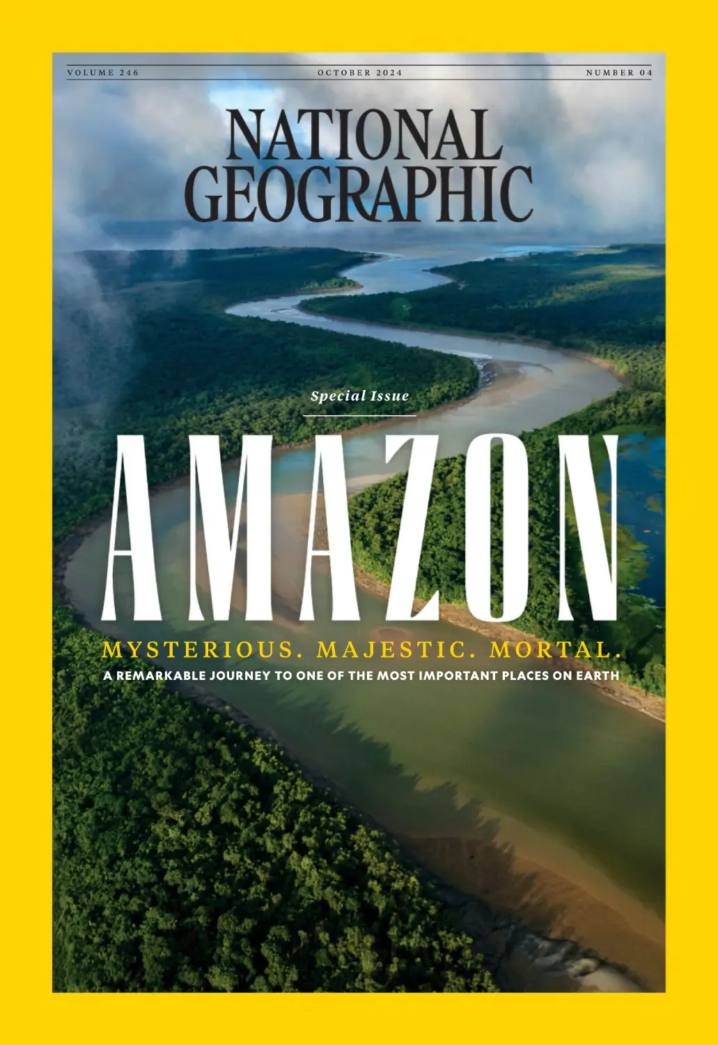
Special Issue
MYSTERIOUS. MA JE STIC. MORTAL .
A REMARKABLE JOURNEY TO ONE OF THE MOST IMPORTANT PLACES ON EARTH
NATIONAL GEOGRAPHIC
FROM the EDITOR
N AT H A N LU M P
in your hands is
genuinely special. It is the culmination
of incredibly deep research, exploration,
inquiry, and documentation designed to
give us all greater insight into one of our
most critical ecosystems.
Amazonia—a popular term for the
waterways and terrestrial areas around
the Amazon River and its tributaries—is
a place like no other. A huge carbon sink
of 344 billion trees. A haven of biodiversity that’s home to 10 percent of the planet’s species. A cultural landscape rich in
knowledge and creativity developed over
millennia. A source of millions of gallons
of water and rich nutrients that feed our
oceans. Our planet would simply not be
the same without it.
Over the past two years, the National
Geographic editorial team has partnered
PHOTO: MARK THIESSEN, NGM STAFF
T H E I S S U E YO U H O L D
OCTOBER
with scientists, researchers, and storytellers in their work across this vast
region—from the Andes to the Atlantic—
in an effort to shine a light on what
Amazonia today is telling us. It’s a story
of great challenges and threats, and
also of hope. One thing is abundantly
clear: We need Amazonia, and Amazonia needs our help.
In these pages you’ll hear from many
members of this expedition, learn what
they’ve learned, and be transported by
the stunning photography of Thomas
Peschak, who spent nearly 400 days in
the field to bring this dynamic ecosystem
to life for National Geographic.
I hope you enjoy the issue.
PAGE.2
2024
HELPS MANAGE
*
BLOOD SUGAR
Glucerna® has a sweet taste that fits
smoothly into your day.
1
#
Scan and
sign up for
up to $80
in benefits†
Doctor-recommended
brand for people
with diabetes
Use as part of a diabetes management plan.
* Designed to help minimize the blood sugar spike from consuming
Glucerna compared to high-glycemic carbohydrates.
† Offers may vary. Valuation based on maximum collective savings
of offers throughout duration of program.
©2024 Abbott 202314641/April 2024 LITHO IN USA
P A I D C O N T E N T F O R R O YA L C O M M I S S I O N F O R A L U L A
FARMING THE DESERT
For thousands of years, humans have done more than survive in the
deserts of Arabia—they’ve thrived there. Now archaeobotanists are
uncovering the secrets of their success: The crops they learned to
cultivate in challenging conditions.
A man climbs a towering date palm tree, his
feet nimbly navigating the trunk, also known
as a stem, like a ladder until he reaches the
canopy. Amid the palm leaves, he pulls a long,
curved blade to expertly cut away a cluster
of dates that he lowers to the ground. It’s a
scene almost unchanged for millennia in the
oasis of AlUla, northwest Saudi Arabia. The
region is renowned for its dates, which have
been essential to oasis life for almost as long
as humans have lived here. The oasis of AlUla
was always more than a vital watering hole for
travelers: It was a community and kingdom
built on farming the desert.
Main image: In the oasis of AlUla, dates have been harvested in the same way for thousands of years. The date
palm tree remains one of the region’s most important cultivated crops. Credit: Matthieu Paley
AlUla’s oasis was formed by a wadi, a desert
ravine that brings water from faraway rains
into the valley. Archaeological evidence shows
that its soil was originally more fertile than
it is today, filled with minerals washed from
neighboring basalt plains in wetter times.
Migrating birds, drawn to the water, deposited
seeds from distant plants and the oasis sprung
to life. We’re unsure what the earliest humans
would have found, but edible plants likely
thrived beneath the sprawling canopies of
acacia trees. These plants would have attracted
animals, including gazelle, that enabled AlUla’s
first inhabitants to maintain the hunter-gather
lifestyle depicted in their enigmatic rock art.
Around 5,000 years ago, the first signs of
potential crops appear in the form of cereal
grains. The challenge for archaeobotanists,
who specialize in studying archaeological plant
remains, is the scarcity of material to work with.
Most plants decompose and disappear without
leaving a trace. But sometimes grains, seeds,
and wood survive, especially when carbonized
by fire. So, where early humans settled and
cooked and discarded rubbish, we find clues
to what they were growing and eating.
is significant because these tall trees are an
essential enabler for desert agriculture. As well
as providing food, they offer shade against a
burning sun and help reduce evaporation to
preserve precious water. In the wild, this allows
more delicate plants to thrive beneath their
canopies, and AlUla’s inhabitants learned from
nature. They developed a three-layer farming
system: The tall date palms sheltered shorter
trees, and below these trees grew even smaller
shrubs and plants. The crops grown at these
lower heights changed over time, but a top layer
of date palms remains a constant to this day.
Piecing together what was grown at the
oasis becomes easier with the emergence of
the Dadanite and Lihyanite kingdoms after
800 BCE. Centered on the city of Dadan, these
kingdoms hosted substantial populations that
“Date stones and
fragments of date palm
trees appear in AlUla
around 3,000 years ago.”
We don’t know if these trees were domesticated
locally or introduced, but their appearance
coincides with evidence of building in AlUla,
perhaps marking the start of the oasis’
development. The presence of date palms
Above: Whether domesticated locally or introduced
from elsewhere, the appearance of date palm trees
around 3,000 years ago coincides with the development
of the oasis in AlUla. Credit: Matthieu Paley
This is paid content. This content does not necessarily reflect
the views of National Geographic or its editorial staff.
2024
P A I D C O N T E N T F O R R O YA L C O M M I S S I O N F O R A L U L A
must have been supported by agriculture.
Inscriptions in the rocks offer prayers for good
rains and harvests, and include references to
the seasons, water, produce, and the lease of
parcels of land, probably to farmers.
Dadan’s archaeobotanical record suggests that
date palms were widespread at this time, and
there were grapevines, pomegranate, and fig
trees. Also found here were annuals, including
lentils and cereals identified as barley and
wheat—though a variety closer to durum wheat
used for pasta.
Sometime after 500 BCE, the town of Hegra
began to emerge. The same plants discovered
at Dadan were here as well, but with the
addition of olive trees. At this time, the people
were probably using wild plants more than
cultivated crops for their fuel needs. After the
Nabataeans arrived and made Hegra their
regional capital, the townspeople became more
reliant on agriculture. Fruit trees were more
numerous in Hegra, suggesting they were being
actively cultivated. This change was supported
by developments in irrigation: 130 wells were
dug at Hegra, and huge cisterns stored water
for use throughout the year.
“By the end of the first
century BCE another
crop appears in Hegra
—cotton.”
Geochemical analyses of cotton seeds and
textiles found there confirm that cotton plants
were cultivated and processed locally. Modern
cotton is a thirsty crop, making it an unusual
find for the deserts of Arabia: Modern cotton
comes from the U.S., whereas the cotton found
in Hegra originated in either Africa or India,
and probably arrived along trade routes.
A small tree rather than shrub, this cotton
was suited to drier conditions and seems to
have grown well, its abundance suggesting
economic importance until Hegra was
abandoned around 500 BCE.
Above: Beneath the shading canopy of towering date palms, farmers over millennia have cultivated citrus, mangoes,
pomegranate, and other fruit along with cereals, vegetables, herbs, and even cotton. Credit: Krystle Wright
Above: Water brings life to the oasis and the oasis brings life to the desert. Across millennia, the cultivation of crops
has enabled communities and even kingdoms to emerge and thrive in AlUla. Credit: Matthieu Paley
The cultivation of cotton continued at Dadan
when it was reoccupied from around the fifth
century and into the Islamic period. Again,
we find date palms, fruit trees, and cereals
demonstrating a logical continuity: AlUla’s
inhabitants knew what grew well and cultivated
plants that met their needs. To these, they added
useful new species revealed by tantalizing
charcoal fragments belonging to an apple, pear,
or quince tree, as well as further remains that
are either apricot or peach. That we don’t know
which species is indicative of the challenge
facing archaeobotanists: Many of AlUla’s
cultivated crops have left little or no evidence.
During the Islamic period, from the seventh
century onward, irrigation leaped forward
with the construction of qanats, gravity-fed
underground channels bringing water from
the mountains to the valley, where it was
channeled to water large areas of farmland. In
the 12th century, a visiting Islamic pilgrim was
moved to describe the region as “a valley with
lush vegetation” where “freshwater springs
irrigate the crops.”
Today, 80 percent of AlUla’s inhabitants work
in agriculture. The oasis is swathed in the
verdant green of two million date palm trees
producing over 90,000 tons of dates annually.
The palms provide shade for thousands of
citrus trees laden with fruits ranging from the
sweet Jaffa orange to the Bin Zihr lemon used
in kabsa, the national dish of Saudi Arabia. Also
among these are the wispy-branched Moringa
peregrina trees, a native species long cultivated
for the luxurious oil extracted from its seeds.
But still, towering above everything, remains
the date palm tree—the key to farming the
desert for thousands of years.
Scan to learn more about AlUla.
To plan a trip to AlUla visit:
www.experiencealula.com
This is paid content. This content does not necessarily reflect
the views of National Geographic or its editorial staff.
2024
VOLUME 246
NATIONAL GEOGRAPHIC
NUMBER 04
CONTENTS
Reporting in this issue is presented by the National Geographic Society in partnership
with Rolex under the National Geographic and Rolex Perpetual Planet Amazon
Expedition. Rolex is partnering with the National Geographic Society on science-based
expeditions to explore, study, and document change in the planet’s unique regions.
6 CONTRIBUTORS
11
72
98
RELEARNING THE
GOLD’S UNSEEN CO ST
P R E D AT O R S O F
AMAZON
Sophisticated tools are
exposing ancient worlds
beneath the rainforest
canopy—vastly changing
our understanding.
A trio of researchers
is studying mining’s
impact and ways
to rejuvenate the land.
74
THE AMAZON
From army ants to
anacondas, top-of-thefood-chain creatures
hunt and eat in an astonishing variety of ways.
AMAZON IN THE
BALANCE
30
T H E F LY I N G R I V E R S
High in the Andes,
where the Amazon
originates, cloud forests
collect moisture and
shelter the Andean bear.
See how human activities, from agriculture
to oil extraction, are
reshaping the rainforest.
76
104
TRICKSTERS, ICONS,
AND THIEVES
River dolphins play starring roles in their watery
worlds and in the beliefs
of Indigenous peoples.
LESSONS IN THE
FLOODED FOREST
52
P E A K O B S E R VA T I O N S
Atop Peru’s nearly
21,000-foot Nevado
Ausangate, scientists
set up a station to
track the weather.
DOLPHIN DIPLOMACY
When a Brazilian
ecologist arrived in the
Amazon hoping to
save it, locals taught
him how.
Collaboration is key to
protecting these aquatic
mammals and the
livelihood of fishermen.
96
120
RIVER INTO SEA
54
T H E U N D E R WA T E R
‘NO ONE KNOWS
WO OD S
THIS PLACE’
These trees evolved to
withstand massive flood
cycles. But can they
survive what’s next?
In a remote Bolivian
canyon, a rare clearwater habitat thrives.
118
The Amazon doesn’t
end at the coast. Its
plume of sediment-rich
fresh water nourishes life
as far as the Caribbean.
1 4 0 N E W F R O M N AT I O N A L G E O G R A P H I C
O N T H E C OV E R A channel cuts through the coastal mangroves and tropical
rainforest of Brazil’s Maracá-Jipioca Ecological Station, near the mouth of the Amazon River.
Photograph by THOMAS PES CHAK
OCTOBER
PAGE.4
2024
Elevate the moment
with Zuke’s Dog Treats.
Shop Now.
Tender treats.
Real protein.
Crafted in the USA.
CONTRIBUTORS
FROM SOURCE TO SEA
A conservation photographer who normally focuses on the ocean immersed
himself in the Amazon Basin to reveal its aquatic wonders—and its challenges.
Short caption about the
camera machine here tktk
tktkkttkk tktktktkttkLore la
cor as et fugitaeris 15 wds
behind our Amazon expedition, Thomas Peschak—a
National Geographic Explorer since 2017—spent more than a year documenting
the world’s most biodiverse rainforest and the scientists studying it. He and his
team, including videographer Otto Whitehead, embedded for weeks and months
in over 30 locations. It was often demanding, says the South Africa–based photojournalist, but his best experiences were “off the charts.” Among them: snorkeling
with a tapir and diving with human-size catfish. — H I C K S W O G A N
T H E D R I V I N G F O RC E
Peschak’s Amazon Tally
490,064
Languages
in which
he learned
how to say
hello
Photographs he made while exploring
the Amazon Basin
OCTOBER
6
PAGE.6
396
Days he spent on
assignment in the field
102
Bee and wasp stings
he and his team endured
1,200
Approximate weight
of expedition equipment, in pounds
2024
PHOTO: OTTO WHITEHEAD
1,931
Books and scientific
papers he read before
the expedition
P R E C I O U S M E TA L C O I N S
AMERICAN ARTISTRY, LUXURIOUS LEGACY
Uncover the pinnacle of craftsmanship with our precious metal coins. From the iconic
American Buffalo to the American Eagle, these stunning silver, gold, platinum, and palladium
coins showcase breathtaking designs and exceptional quality. Whether you're looking for a
unique and timeless gift, or ready to start your collection, these exquisite masterpieces are
sure to impress. Discover your piece of history.
2024 AMERICAN
EAGLE 1 OUNCE
GOLD PROOF COIN
2024 FIRST AMENDMENT
TO THE U.S. CONSTITUTION –
RIGHT TO ASSEMBLE
PLATINUM PROOF COIN
2024 AMERICAN EAGLE
1 OUNCE PALLADIUM
PROOF COIN
2024 AMERICAN
BUFFALO 1 OUNCE
GOLD PROOF COIN
Products and coins shown are not actual size or in proportion. Coin and product photos ©2024 United States Mint.
The United States Mint’s numismatic programs are self-sustaining and operate at no cost to the taxpayer.
CONTRIBUTORS
N AT I O N A L G E O G R A P H I C
EXPLORERS
These contributors have received funding from
the National Geographic Society, which is committed to
illuminating and protecting the wonder of our world.
Angelo Bernardino,
p.1 20
An Explorer since
2021 and founder
of the Brazilian nonprofit Instituto Juruá,
he leads a team
that’s developing
and implementing
community-based
conservation solutions in rural Amazonia. He specializes
in the once endangered arapaima, a
gigantic fish crucial
to the culture of
flooding lowlands,
the subject he wrote
about for this issue.
This oceanographer
at Brazil’s Universidade Federal do
Espírito Santo led a
research team that
recently identified
a new kind of mangrove forest at
the mouth of the
Amazon, an area he
covers in this feature.
An Explorer since
2018, Bernardino
is also a dedicated
ocean paddler—on
the water by dawn
every morning in
his outrigger canoe.
Eduardo Neves,
p.1 1
The professor,
archaeologist, and
museum director at
Brazil’s University of
São Paulo has spent
35 years researching
the Amazon’s early
cultures, knowledge
he drew on for this
issue’s introduction.
An Explorer since
2012, he now directs
the Society-funded
Amazon Revealed
project, which identifies and maps ancient
human occupations
in the rainforest.
Cynthia Gorney,
Jordan Salama,
p p. 3 0, 76, 1 2 0
pp.54, 104, 1 18
A former South America bureau chief for
the Washington Post,
Gorney is a journalism
professor emerita
at the University of
California, Berkeley. She’s written for National
Geographic since 2008, reporting from Saudi
Arabia, Uganda, and Bosnia. Her feature on
the sense of touch ran in the June 2022 issue.
OCTOBER
Ruthmery Pillco
Huarcaya, p . 3 0
Raised in a Quechua
village in the Peruvian Andes, Pillco is
a biologist helming
a research team high
in the cloud forest.
For this issue, she
wrote about the
focus of their studies:
the elusive Andean
bear and its vital role
in the ecology of
the Amazon Basin.
A favorite collaborator? Her rescue
dog turned bear
tracker. She became
an Explorer in 2021.
Salama’s features on
pink river dolphins
and the headwaters
of Bolivia’s Sécure
River are some of his
latest stories on South
America. For his recent book, Stranger in
the Desert, the New York–based writer
traversed the Argentine Andes in search
of his family’s lost history.
2024
PHOTOS (CLOCKWISE FROM TOP LEFT): ANDRÉ DIB; PABLO ALBARENGA; FLORENCE GOUPIL (NATIONAL
GEOGRAPHIC FOR PREVIOUS THREE); MARK THIESSEN, NGM STAFF; LUIS ALFREDO CEBALLOS; ELÍAS CONDORI
João Campos-Silva,
p.76
I
N E W D I S C O V E R I E S AWA I T
I AVA I L A B L E W H E R E V E R B O O K S A R E S O L D
NatGeoBooks
© 2024 National Geographic Partners, LLC
F I N D YO U R P E O P L E
IN A LAND
WITHOUT PEOPLE
Even if you’re traveling to the only continent without permanent residents, when you join an
Expedition Cruise, you’re getting the opportunity to explore the world alongside like-minded
travelers and National Geographic Experts. The penguins are nice company, too.
N ATG E O E X P E D I T I O N S .C O M
|
1 - 8 8 8 -3 51 -3 274
SPECIAL
I N T R O D U CT I O N
1. THE SOURCE
2 . HIDDEN HEADWATERS
3. THE PULSE
4. RAINFORE ST HUNTERS
5. RIVER AMBAS SADORS
6. THE REACH
N ATG E O.C O M /A M A ZO N - S P E C I A L
Photographs by T H O M A S P E S C H A K
ISSUE
In a forest flooded
by Brazil’s Rio Negro,
an Amazon tributary,
guide Roberto Abdias
Gomes da Silva points
toward the high-water
line on the massive buttress roots of a kapok
tree, a species that can
grow over 200 feet
tall. Its trunk acts like
a water tank, storing
moisture during seasonal floods to sustain
it through dry periods.
Words by
EDUARDO NEVES
For 500 years, outsiders have misunderstood the world’s
largest rainforest. That’s finally changing.
The story of how the Amazon got its name
begins on June 24, 1542. Francisco de Orellana
was praying for an escape from the green world
that had swallowed his beleaguered expedition. The Spaniard’s two boats, containing
fewer than 50 starving men, were nearing what
the crew hoped would be their salvation. After
seven months of navigating a series of tributaries beginning at the foot of the Andes, they’d
finally reached the largest river any of them
had ever seen, and Orellana hoped it would
soon lead them to the Atlantic Ocean.
He was accompanied by Gaspar de Carvajal,
a Dominican friar, who kept a detailed chronicle of their journey. The priest recorded the
Europeans’ astonishment at the advanced cultures they encountered—densely populated
villages along the riverside, including one that
stretched on for many miles. He described
networks of wide roads, beautiful plazas and
fortified palisades, carefully cultivated farms,
and painted pottery as fine as any in Spain.
Along the way, some communities welcomed
them with generosity—feeding them manioc,
yams, corn, and turtles. But on this June day,
still some 600 miles from the end of the enormous river, they were attacked by an army of
warriors led by ferocious women “who fought
so courageously that the Indian men did not
dare to turn their backs.” Carvajal, who came
out of the battle with an arrow in his side,
compared the women to the Amazons of
Greek legend. His accounts of the voyage, the
first by a European to traverse South America,
would later be dismissed as fantasy by Spanish authorities. And yet, the term “Amazon,”
however inapt, would come to identify this
vast and complex region. Since then, the Amazon has been defined by many myths, which
only in recent years archaeologists, like me,
and other scientists have begun to unravel.
of
the Amazon, and it’s easy to fall
prey to the myth that it’s a pristine jungle. It appears like a green
mantle, composed of 344 billion
trees covering much of the northern half of South America. Zoom
in, and you find a labyrinth of river valleys;
more than 6,200 rivers and tributaries drain
an area roughly the size of the contiguous
United States. It’s the planet’s largest, most
bio diverse tropical rainforest. Roughly
L I C K O N A S AT E L L I T E I M A G E
Reporting in this issue is presented by the National Geographic Society in partnership with Rolex under the
National Geographic and Rolex Perpetual Planet Amazon Expedition.
®
PRO PLAN VITAL SYSTEMS
works by nourishing 4 key systems for your cat’s lifelong health.
One more way we’re always advancing nutrition for your cat.
IMMUNE + DIGESTIVE + MUSCLES + BRAIN
Learn more about our breakthroughs for cats.
Purina trademarks are owned by Société des Produits Nestlé S.A.
10 percent of all Earth’s plant and animal species live there. The Amazon shelters 40,000
species of seed plants, 2,400 species of fish,
1,300 species of birds, and 1,500 species of
butterflies. Such a place, it would seem, must
have been left largely untouched by humans.
But this is one of the enduring misconceptions that over the past four decades scientists
have been methodically debunking.
Thanks to rock art, stone tools, and other
remains found in remote areas in Colombia
and Brazil, we know the human presence
in the Amazon Basin extends back at least
13,000 years. Ancient Amazonians were
depicting Pleistocene creatures, including
mastodons and giant sloths, around the
same time ancient Europeans were painting
mammoths and woolly rhinos. Over time,
those Amazonian populations grew, and
by 1492, scientists estimate, the region was
home to as many as 10 million people.
So why have so many people gotten the
Amazon so wrong for so long? In the centuries
that followed Orellana’s journey, Portuguese
efforts to colonize the heart of the Amazon and
extract its resources decimated the populations. Smallpox and other diseases introduced
by Europeans are believed to have wiped out
upwards of 90 percent of the Native peoples.
And the practice of slave raiding drove most
of the survivors into the far reaches of the interior, effectively converting settled farmers into
nomadic hunter-gatherers. So in the 1700s,
when the first European naturalists arrived,
they found large areas covered in dense jungle vegetation with few people around and
assumed it had always been like this.
Because of this depopulation, the large
An ancient mural on a rock wall in Colombia’s Chiribiquete National Park depicts
jaguars, large rodents called pacas, and piranhas. More than 75,000 paintings
have been found in the region, portraying scenes from the prehistoric Amazon.
On The Trail Of
LEWIS & CLARK
COLUMBIA AND SNAKE RIVERS
Follow Lewis and Clark’s epic 19th-century
expedition along the Columbia and Snake Rivers
aboard the newest riverboat in the region. Enjoy
unique shore excursions, scenic landscapes, and
talented onboard experts who bring history to life.
Experience the
Grandeur of
Multnomah Falls
Cruise Close To Home®
Spokane
WASHINGTON
Mount St. Helens
Pacific
Ocean
Fort
Clatsop
Kalama
Stevenson
Washougal
Portland
OREGON
IDAHO
Snak e Riv e r
Astoria
Hood River
Clarkston
Richland
Lewiston
mbia River
Colu
Umatilla
The Dalles
Multnomah
Falls
Mt. Hood
Pendleton
Hells
Canyon
Call
800-894-8649
to request a
FREE
Cruise Guide
AmericanCruiseLines.com
18
settlements Carvajal had described, built
from wood and straw (there’s not enough rock
in the Amazon for masonry), had long since
rotted away in the wet tropical environment.
Large human-made mounds were labeled as
natural formations, and the region’s staggering number of languages was attributed to
successive waves of immigrants that came
to the rainforest from elsewhere on the continent. By the late 1800s and the apex of the
rubber boom—a period of extreme violence
against Indigenous peoples—anthropologists
were erroneously describing Native societies
as small, nomadic groups. That picture consolidated during the 20th century and still
shapes the image that many outsiders have
about the Indigenous history of the Amazon.
This was the prevailing view when I graduated from college in the 1980s, but then I
met two American anthropologists working
with Indigenous groups in the eastern Amazon. Darrell Posey told me how he’d documented the Kayapó planting “forest islands”
in savanna areas as they hunted and collected
fruits and nuts. William Balée described how
the Ka’apor used fire to foster the growth of
palm groves. Both groups were clearly engineering their landscape to suit their needs.
This idea led me into a career looking for new
answers about the history of the Amazon.
Nearly four decades later, researchers have
uncovered an overwhelming body of new
evidence. The trees tell us part of the story. By
surveying the rainforest, we find that half of
the Amazon’s trees come from only 299 species. These so-called hyperdominant species
are especially useful to humans—including
acai, rubber, Brazil nut, and cacao. We tend
to find these trees in abundance near preColumbian archaeological sites, which points
Pilgrims dressed up as ukukus—mythical bearhumans—climb glaciers above Peru’s Sinakara
Valley during the Qoyllur Riti festival. The once
plentiful ice, considered sacred, is now receding.
19
H AV E YO U
R O L L E D OV E R?
P H OTO G R A P H BY M I C H A E L N I C H O L S
TOGETHER WE CAN CHANGE THE WORLD
to a long-standing practice of Indigenous people curating the Amazon forests.
But it wasn’t just the trees that the early
Amazonians were curating; it was the soil
too. Beginning in the 1970s, scholars argued
that the “Amazon was a counterfeit paradise.”
Despite the lush jungle, its highly acidic soils
lacked nutrients crucial for intensive agriculture and, therefore, couldn’t have yielded
enough food to support large, concentrated
populations. But scientists noticed Indigenous
people growing crops on plots of something
called terra preta—dark earth—which is soil
mixed with charcoal and organic matter and
often pieces of broken ceramics. Not only are
such spots highly fertile, but they can remain
so for centuries, with little or no fertilizer
added. Archaeologists have found terra preta
throughout the Amazon and have dated some
as far back as 5,000 years.
But what about the Amazonian cities that
Carvajal and other early Europeans described?
As recently as 2008, my colleague Michael
Heckenberger was criticized for suggesting
that there was widespread urbanism in the
Amazon. But then came lidar—a laser scanning system—that has allowed us to peer
through the dense rainforest canopy and see
how early societies shaped the land. While
I was working in Bolivia in 2019, colleagues
were using lidar to map complex urban settlements belonging to the Casarabe culture,
which lasted from around A.D. 500 to about
1400. The settlements were linked to each
other by causeways several miles long and
included canals and reservoirs and earthen
pyramids. Lidar has revealed about a thousand
large, intricate settlements throughout the
Amazon, effectively rewriting its history and
showing us that, as in Europe and Asia, there
wasn’t a single Amazonian culture but many.
Now my work, partly funded by the National
Geographic Society, focuses on partnering
with Indigenous communities to do lidar surveys of their land, especially near areas that
have been deforested or are threatened. By
finding archaeological sites, we’re able to apply
for stricter protections from the Brazilian
government. The hope is to use archaeology
to build a firewall around the rainforest.
historical picture
is emerging, scholars continue to
make discoveries in the natural
world. On average, a new Amazonian species is described for
science every other day. Just this
February, scientists announced a
new species of anaconda, the world’s heaviest
snake. Every day new parts of the story come
into sharper focus.
It’s in this spirit that the National Geographic and Rolex Perpetual Planet Amazon
Expedition was launched, supporting the
research of 16 scientists—11 of whom are from
South America—working in a range of disciplines with local collaborators at sites spread
from the Andes to the Atlantic coast. In the following pages, you’ll find their discoveries, documented by photographer Thomas Peschak
and his assistant, Otto Whitehead, who in visiting their research sites traced a path from the
river’s source in the Andes glaciers all the way
to its plume extending into the Caribbean.
It’s desperately important work. Since
I began working in the Brazilian Amazon
in 1986, 12 percent of the forest has been
destroyed, much of it by illegal logging.
Meanwhile, illicit gold mining is out of
control in many countries, and organized
crime is increasingly using it and other
unlawful activities in the Amazon to launder
money from drug trafficking. At times, the
future seems dire, but I am sure that we can
find ways to change it. Scientists and politicians have a lot to learn from Indigenous
peoples and the ways they have managed
and shaped the complex natural systems
of the Amazon through the millennia. The
first lesson they can teach us is that to chart
a sustainable future for the Amazon, we
should look to its past. j
S THIS REVISED
21
Pink dolphins navigate
a flooded forest in the
Rio Negro’s tannintinted waters. Supreme
hunters, these dolphins
feast on 50-odd fish
species, using coneshaped front teeth to
grab their prey. Scientists believe stiff hairs on
their snouts give them
a sense of touch when
foraging in mud for turtles, crabs, and shrimps.
THE
AQUATIC
AMAZON
Spanning the continent, the basins of the
mighty Amazon River and its tributaries
contain and support the world’s largest
rainforest and countless species of flora and
fauna. Originating in the high Andes, then
swiftly flowing into the basin, the waters
cycle from ice melt and cloud to torrential
rains that seasonally flood the densely
forested valleys—a perpetual exchange
between the terrestrial and the aquatic.
UNITED
STATES
Nevado Ausangate, the
highest mountain in
the Andes of southern
Peru, looms above a
waterfall fed by glacial
melt. Communities and
ecosystems hundreds
of miles downstream
rely on glacial melt
as a primary freshwater
source, especially
during dry seasons
and times of drought.
Amazon Aquatic
Ecosystem
at same
scale
SOUTH
AMERICA
750 mi
750 km
Trinidad
Caracas
Orinoco
River
Delta
Es
s
Ama
N
O
S
Y
Su T
Ma m
o ré
Beni
N
Vilhena
s
Pa
Santa Ana
O
RurrenabaqueL
Lake
Titicaca
o
re
ci
s
I
D
Cuiabá
Rondonópolis
P
Roboré
an
Corumbá
PA R A G U AY
al
S
ILE
CH
Sucre
Camiri
nt
Santa Cruz
Barra do Garça
Iporá
H
a
E
Aiquile
R
Pontes e Lacerda
V
r
e
Y
Sorata
B
S
Trinidad
Ascención I
u Séc u
A
N.P.
G
nIsiboro Sécure
San Ignacio
r
Puerto
a
La Paz
g Villarroel nd e
a
Cochabamba s
Source
of the Nevado
Amazon Mismi
Sinop
r
bado
Tom
B
a po
ré
d
Cusco
a
Madidi N.P.
do
Ron
cador
ad
Manú
National Park
Gu
er
ra
Pimenta Bueno
p
Puerto
Maldonado
o
ra d
Ser
a
á
Z
sa
h
A
r mo
Ji-Paraná
R
Aripuanã
r u e na
C
B
Ju
It
a
GuajaráMirim
A
MATTHEW W. CHWASTYK AND DIANA MARQUES, NGM STAFF
SOURCES: ANA P. BARROS, UNIVERSITY OF ILLINOIS URBANA-CHAMPAIGN; SCIENCE
FOR NATURE AND PEOPLE PARTNERSHIP; ESA; NASA/JPL; OPENSTREETMAP
C
Pi
re
s
Ariquemes
Cobija
Ñ
18,363 ft
5,597 m
E
ir
de
Ma Porto Velho
Riberalta
A
A
T
Jacareacanga
Teles
i
ux
ã
un
Ab
T
ac
N
I C
Humaitá
Rio Branco
Lima
T
s ra
ei
ad
M Manicoré
I
U A
Sena Madureira P u r u s
San Ramón
Altamira
Ta
pa
a
S Tapauá
A Q
P
Xin
g
Z
Santarém
Itaituba
Purus
Ju
A
O
22,205 ft
6,768 m
Ayacucho
v
Cruzeiro do Sul
Nevado Huascarán
ím
Coari
a
Ji-P r a n
N
r
pu
O
A
U
M
L A
l
a
R
i
r
l
Ucayal
t
ta
n
E ien
e
Or
C
P
ra
a
r
le
il
l e
rd
i l
d
r
o
B
M A
zo
Itacoatiara
ruá
Ju
l
ta
í
e
Java
ri
N
o
C
A
S
Pucallpa
O C E A N
e
Bran
co
n
C
Ma ra ñ ó n
Requena
Gurupá
p
Island
Óbidos
Parint
ins
)
Tefé
Leticia
Amapá
ngu
Xi
(So
Saint-G
Macapá
u
N
Manaus
Iquitos
P A C I F I C
O
Cape O
Vila
Serra Fo
O
O
C
E
D
Z
(FRANCE)
r
o
yo
Balbina
Reservoir
Amliamzõoens
u rá
FRENCH
GUIANA
Pa
A
J
ap
Negro
Barcelos
Cayenne
S e r r a d e Tu m u
cum a q u
Caracaraí
EQUATOR
M
A
A
N Wilhelmina Mts.
D
S
Kanuku
Mts.
SURINAME
GUYANA
ou
Boa Vista
Source of
the Orinoco
Amazo
Juanjuí
L
Pico da Neblina
Putuma
Cuenca
Van
Blommestein
Meer
i
Jar
Serranía de
Chiribiquete
National
Natural Park
A
Na p
H
Urba
River
Paramaribo
Trombe t a s
Puyo
G
oco
9,826 ft
2,995 m
Mitú
M
ima
Georgetown
n
Ori
no
c
r in
I níri d a
São Gabriel
da Cachoeira
EC U AD OR
I
nt
Pakara
La Esmeralda
Quito
Yasuní N.P.
H
L
I
A
s
N
ain
A
O
0°
9,220 ft
2,810 m
A
I
Inírida
L
rd
U
Fo
Gr
an
Cr
O C E A N
Guri
Reservoir
G
Land c
A T L A N T I C
Mt. Roraima
M
il
A
A
o
Guaviare
L
Co
S
N
B
le
ra
Or
iental
O
E L
Maroni
Bogotá
E Z U
S
j ós
V E N
Panama City
e q uibo
´
PANAMA
I
cover
Hydrology
Area subject to
inundation
S
Ba ão
cos
ar
M
y
Gua
po
Fortaleza
Presidente
Dutra
Banana
l Island
Clear water
These rivers are low in
sediments because they
flow through ancient
shields of hard rock.
Crato
Balsas
Recife
L
Maceió
Palmas
WAT E R C YC L E O F L I F E
Much of the Amazon Basin’s water is returned to the
forest as rain. The remainder is carried by east-west
winds as an aerial current—a mix of moist ocean
air and some transpiration from the forest—that is
directed south when coming up against the Andes.
Aracaju
Gurupi
Barreiras
Alvorada
Z
L
u
ré
200 km
White water
Nutrient-rich water
laden with sediments
flows out of the Andes,
clouding these rivers.
Floriano
I
A
A Z I
n
200 mi
aia
Tocan
ti
Ar
Araguaína
ns
OCEAN
BOLIVIA
Natal
M a gu
Ta
pa
B R
São Luís
Imperatriz
s
jó
PERU
Teresina
E
Bran
co
P ur
Santa
Inês
Se
rra
Tucuruí
Reservoir
a
eir
ad
M
us
do
Tucuruí
Marabá
aí
ut J
Tir
Paragominas
ari
av
ATLANTIC
Amaz o
Putumayo
azon
m
A
J
acam
bu
Tocanti
ns
Belém
Portel
Negro
tá
0°
jó Bay
ara
M
Bragança
Marajó
Island
ECU.
que
GUY.
T o c a n t i ns
Mouths
of the
Amazon
Ca
ru
Pa
Acidic and low in
nutrients, these rivers
are darkened by
decomposing plants.
Maracá I.
SUR.
COLOMBIA
Black water
100 km
a Velha
FRENCH GUIANA (FR.)
VENZ.
100 mi
uá
eorges
ur
Orange
Aragu
aia
Limit of the Amazon
Aquatic Ecosystem
The freshwater system of
climate, life, and landscape
drained by the Amazon and
the adjacent rivers that flow
into its discharge plume
Xin
g
Amazon discharge plume
n area
Other road
Main road
R
A N D E S TO AT L A N T I C
From mountain headwaters to tributaries, water
takes on sediments and chemicals that change
its appearance and characteristics as it flows over
different terrain. More than 58 million gallons,
enough to fill 88 Olympic swimming pools, flow from
the Amazon’s mouths into the Atlantic every second.
J
orest
rassland
nd rangeland
ropland
I
L
I
A
N
Salvador
WATER RECYCLING
Niquelândia
Ilhéus
Goianésia
as
Condensation
Aerial river
Formosa
Brasília
Wind
Goiânia
G
H
Rain
L
A
N
D
Evapotranspiration
Evaporation
S
PACIFIC
OCEAN
Uberlândia
Belo Horizonte
ANDES
Flow direction
AMAZON BASIN
ATLANTIC
OCEAN
THE SOURCE
Photographs by T H O M A S P E S C H A K
Words by R U T H M E R Y P I L L C O H U A R C A Y A
High in the Andes, a land of towering
glaciers, dense cloud forests, and elusive
bears shapes the Amazon River Basin.
30
Combining a traditional skirt with alpine
gear, Senobio Llusco,
a member of Bolivia’s
Aymara people, accompanies a National Geographic team to install
a weather station atop
Nevado Ausangate, a
21,000-foot peak in the
Peruvian Andes. Among
the new station’s tasks:
recording moisture
of the glaciers, whose
high-altitude melt helps
feed the Amazon River.
Icy condor feathers
shine in the mist of a
cliffside spring atop
Nevado Mismi in the
Peruvian Andes. While
streams and tributaries
coalesce from many
directions to become
the Amazon River, this
volcanic peak is the
farthest source of
uninterrupted flow
from the river’s mouth
at the Atlantic.
The bats on the ceiling start skittering, and as the light comes
up, I can watch the clouds slide along the steep forested ridges
outside. They’re rivers in the air, these clouds. Ríos voladores,
flying rivers, they carry moisture that will make its way into
soil, and then creeks, and hundreds of miles of river on the
ground, all the way out to the sea. I grew up not far from here,
but what truly taught me the ríos voladores lesson was a single
day of desperation: me stuck amid the dense foliage of these
mountains, parched with thirst.
Let me back up. I came to this station and laboratory, a few
hours’ drive east of Cusco, to study the Andean bear, an elusive animal whose critical role in the Amazonian ecosystem
we’re just now coming to appreciate. It was May of 2021, and
I’d been living here for two weeks with Ukuku, the shelter
dog I’d adopted and trained as a bear tracker. A crew of helpers
lived here too, most from nearby villages, and our first big mission was a multiday trek to put in place four dozen cameras, at
spaced intervals, along a wooded mountain stretch of what we
hoped was bear territory. At first, we had horses for the cargo,
but the treacherous slopes were too much for them. The horses
were sent home, and we put everything on our backs: cameras,
tents, food, water, hammocks for overnighting on the steepest
slopes, and machetes for clearing the way.
Those packs were heavy. I’m a small person, and with 60
pounds on my back I stepped carefully, one footfall at a time.
Even as one of us cut brush with the machete up ahead, the
34
A Peruvian artisan
weaves an image of
an ukuku, the South
American bear venerated
in Quechua stories and a
vital part of Amazonia’s
Andean ecosystem.
ground moss and bramble beneath us hid
pits that could break a leg. The nights were
so cold; when Ukuku started shivering, she
nosed into my sleeping bag, and we kept each
other warm. By day five the crew had stopped
amid the thickest foliage I’d ever seen, not
quite sure how far up we’d climbed from the
river at the mountain’s base. Our food was
running low. We were out of water. We could
find no rivulets or puddles. We all grasped the
grim comedy of the situation: Deep inside the
bosque de nubes—the cloud forest!—we were
frantic for something to drink.
Then Narciso said: The tree beards.
Narciso Llaqta is part of our crew, a Quechua speaker and guide who knows the
mountains better than I do. He put his hand
on a tree, pulled away some of the moss that
covers so much of the bark in these forests,
and squeezed the tiny stems and leaves until
Reporting in this issue is presented by the National Geographic Society in partnership with Rolex under the
National Geographic and Rolex Perpetual Planet Amazon Expedition.
Biologist Ruthmery
Pillco Huarcaya, who
was raised in a Quechua
village not far from her
mountainside field station, holds a flowering
bromeliad, a favorite
food of the Andean
bear. Her research takes
her team of scientists
and tracker dog Ukuku
deep into the Peruvian
cloud forest to follow
the fast-moving bears.
beads of water appeared—a few, then more,
then droplets so fat we could see them splash
on the ground. In Quechua these mosses are
sometimes called sachaq sunkha, the beard of
the tree. I knew they act as sponges, moisture
receptacles amid Andean clouds, and now
I watched as one of our crew members held
a cup under the trickle of water Narciso was
squeezing from his fistful of moss.
The cup filled. We brought out more cups.
Mariano Huanca, who also grew up nearby,
thought of the forest’s bromeliads—flowering
plants with creased leaves straight as daggers.
Mariano has worked with scientists who study
amphibians, and he had seen bowl-shaped
bromeliad centers, from which the leaves fan
out, hold enough water to become tiny pools
for frogs. Biologists speak of bromeliads as
water tanks, in fact, and as we found bromeliads and tree beards collecting water that was
38
brown with silt, somebody else remembered how to improvise
a water filter. So there we all stood, exhausted explorers in our
swath of Amazonia, curving up the bottoms of our T-shirts to
strain cloud forest water into cups.
for “bear,” and in
South America there’s only one kind of bear: the
round-eyed black Andean. Its range may extend
a long way south of the Amazon River; in the past
there hasn’t been much study of Andean bears,
and some of what we think we know about them
comes from rumor. Can an Andean bear really
bend himself into a furry sphere when he wants to make a
quick exit and roll like a ball straight down a hill? People here
swear they’ve seen this. We know that even though they’re not
big bears, maybe 250 pounds as adults, they’re tremendously
powerful. An Andean bear can pull a dead cow up a 60-foot
tree, hiding the carcass from other bears, to store it in the
treetop canopy as food.
When I was a child, though, listening to my grandmother
explain the world to me in Quechua, “ukuku” conjured a being
more ephemeral than animal. Village dogs and chickens were
animals. Cuys, the guinea pigs that trotted across our kitchen
floor before being turned into part of our diet—those were
animals. The ukukus of our stories were not exactly divine,
but they were bound to us in mystical ways that we still honor.
They were guardians of the Andean glaciers, the stories told
us, occasionally taking women as brides. Their bear-human
children carried glacier ice from the highest mountaintops to
deliver water to the villages.
My research is teaching me that there’s serious science in
that idea, the Andean bear as life-protecting delivery system
here. But in my childhood imagination the ukukus just hovered, part of the physical and spiritual Quechua landscape.
To be clear, I was a tough little rebel; my parents started me
in kindergarten when I was four. They said I was ready. Maybe
they just wanted me out from underfoot. My given name was
Edyflor, which I disliked—too much like coliflor, the Spanish
for “cauliflower,” no four-year-old girl wants to think of herself as a cauliflower—and on the day they first walked me to
school to sign me up, we passed a house in which I knew, from
overhearing the residents’ calls to each other, that one was
named Rosemary.
“I want that name,” I announced, and stopped walking. “I will
only go to school if you let me change my name to Rosemary.”
KU KU I S T H E Q U E C H UA WO R D
An Andean bear, made
famous by the Paddington children’s books,
blinks back to consciousness after a tranquilizer
let scientists fit on
a geolocation collar.
SIZING THEM UP
Not all bears climb, and most
of the world’s eight species
of bears are omnivores.
Main diet
Plants
Insects
Meat
NON-CLIMBER
INFREQUENT CLIMBERS
1,400 lb
1,200 lb
Polar bear
Ursus maritimus
320 lb
Sloth bear
Melursus ursinus
Brown bear
Ursus arctos
Large adult shown. Weight
varies within a species.
LAND OF THE ANDEAN BEAR
The only bear species in South America, these stout, striped-face
bears are adapted to the misty mountains of the Andes, where
they’re believed to play a key role in forest regeneration.
Short-faced
ANDEAN
BEAR
POLAR
BEAR
Strong jaws and wide, flat
molars are an adaptation for
chewing tough vegetation,
unlike bears with sharp teeth
adapted for biting flesh.
N E ST I N G
Females create nests
for their small litters
of cubs by piling up
leaves and branches.
Cubs are dependent
up to two years.
Bears build
nests on
cliff ledges.
Flat
Sharp
Li g
ht
E AT I N G
Letting in light
Breaking branches
to make platforms
for resting also benefits the forest by
allowing light onto
the forest floor.
Leaving their mark
Clawing, biting, and
rubbing body scent
on trees are different
ways they might
communicate.
7.2 ft tall
LESS FREQUENT CLIMBERS
FREQUENT CLIMBERS
130-390 lb
190 lb
330 lb
Giant panda
Ailuropoda melanoleuca
440 lb
500 lb
Asiatic black bear
Ursus thibetanus
N. American black bear
Ursus americanus
Sun bear
Helarctos malayanus
CLIMBING
200 mi
Andean bears are excellent
climbers and spend much of
their time in trees. Foraging
for food takes up to 70 percent
of their active time.
200 km
Andean bear
Tremarctos ornatus
S
VENEZUELA
E
Longer
front limbs
D
COLOMBIA
N
WHERE
THEY’RE
FOUND
A
Inhabiting grassland and forest
from 650 to
16,000 feet, they
seem to prefer
food-abundant,
high-elevation
cloud forests.
ECUADOR
Bromeliad,
a favored
food
Andean bear range
A
P E R U
N
D
Wayqecha
Cloud Forest
Biological Station
BO L IV I A
E
S
Brown bear (grizzly)
Wild avocado
Andean bear
Gripping claws
Curved claws make
for a firm grip when
climbing trees to
forage, rest, or nest.
Spreading seeds
The bears help regenerate the forest by
dispersing seeds of the
plants they eat, including fruits, in their waste.
Fur patterns
are as individual as human
fingerprints.
GRAPHIC: FERNANDO G.
BAPTISTA, PATRICIA HEALY,
EVE CONANT, LUCAS
PETRIN, AND SOREN
WALLJASPER, NGM STAFF.
SOURCES: ARMANDO
CASTELLANOS, ANDEAN
BEAR FOUNDATION; BORJA
FIGUEIRIDO, U. DE MÁLAGA;
DAVE GARSHELIS, IUCN SSC
BEAR SPECIALIST GROUP;
TERESA HSU, SMITHSONIAN’S NAT. MUS. OF NAT.
HIST.; RUTHMERY PILLCO
HUARCAYA, CONSERVACIÓN AMAZÓNICA-ACCA
ARG.
High above the Peruvian Andes, patterns
of life are etched into
a valley. On the left, a
web of watery veins
courses through a
mossy peat bog at the
valley bottom. The
lines to the right are
trails scored into the
hillside by herds of
alpacas and vicuñas.
A rebel, as I said. There were two younger
kids at home, and my father was away a lot
working in the fields or other villages, so my
parents had more urgent matters to deal with.
They gave in—OK, Rosemary, whatever—and
then the teacher misheard the name and misspelled it in her ledger. So I became Ruthmery,
and the school made me tougher; we were
forced to speak only Spanish inside, and I
was always the smallest among my friends.
I used to find lizards around the schoolyard
and drop them into the boys’ backpacks. We’d
run around the village together, making nuisances of ourselves; the women would scold us
in our more familiar Quechua. Heqas! Brats!
And the bears? I don’t know how to explain
this, but they kept reappearing. Not literally,
I mean, but in my spirit, in my life. There was
a videocassette player in the town secondary
school, and one day when I was maybe 14,
somebody put in a dubbed version of the animated Disney movie Brother Bear. It’s set in
Alaska, where bears, humans, and spirits all
interact, and as I watched, I swear I felt something happening in me—some powerful tie,
me and the animals. I remember it to this day.
I’m connected to bears. I want to be a bear.
I told nobody. Tucked it away in my head.
But as I made it to the national university in
Cusco—llaqtamanta lloqsinayki! my grandmother used to urge, leave this town! go off
to learn and explore—that conviction of
connection stayed with me. My developing
interest in biology would eventually take me
to London, for conservation research at the
Kew Royal Botanic Gardens; when people
there learned where I was from, they would
nod and say, “Ah! Paddington Bear!” You
might recall that in the children’s book, the
hero Paddington, when he appears in Britain (wearing an old hat), is from “darkest
Peru.” That means Paddington would be a
“spectacled” bear (his real-life counterparts
often have facial fur that makes them look
as though they’re wearing glasses), or, more
formally: Tremarctos ornatos.
There was so much other animal and plant
life to absorb during those years, of course.
My parents only now are coming to see why I
always wrote biología on the forms that asked
us to choose our college major—they assumed
that if I really was going to leave my village and
family, it would be to train as a medical doctor,
a professional career they better understood.
But biology fascinated me. I loved the science
of the natural world. When I was awarded a
spot on an undergraduate expedition, multiple
weeks in the mountains and jungles of central
Peru, I had to scrounge secondhand stores for
basic equipment; I owned no proper hiking
shoes, no proper backpack. And as difficult
as remote field research proved to be—there
were tears, I was so tired sometimes, I felt so
completely far from home—I loved that too.
as more opportunities came, I worked with
birds, monkeys, mushrooms,
rare trees in Costa Rica. The village school had made me learn
Spanish; as a graduate student,
with offers from abroad, I had
to learn English as well. Then in 2020, my
mentors and fellow biologists—Andrew Whitworth, also a National Geographic Explorer,
and Adrian Forsyth—told me the Peruvian
nonprofit Conservación Amazonica, which
Forsyth had co-founded, wanted a researcher
to take over an isolated station in the cloud
forest. The new project: Andean bears. Their
role in the forest’s ecology needed deeper
study, especially under the urgent pressures
of climate change. “Vamos,” I said.
Wayqecha, as our station is called, is a cluster of wood buildings—a laboratory, a dining
hall, a dormitory. The road to reach us twists
cliffside into the cloud forest, too narrow in
places for two cars to pass; drivers honk as
warning at the blind curves. When the clouds
are low, long drops of foliage disappear into
the mist. When there’s a break and a bit of
blue, we can see the far-off depths of forested
VER THE YEARS,
44
valley and then more mountains, their peaks
still shrouded, undulating into the horizon.
It may be strange, for someone trying to
take in a full Amazonia map, to imagine
mountain-scrambling bears fitting in along
with everything else. But like monkeys,
macaws, and dolphins, the bears of the cloud
forest are part of the cycle sustaining this
whole river basin, even when the closest real
waterway seems a long distance away. Every
time an Andean bear eats a plant, climbs
uphill for hours, and excretes the seeds
miles higher than where it started, that bear
is spreading foliage. Seeds often germinate
more quickly when they’ve been partially
digested, and these seeds are landing amid
a dollop of bear scat fertilizer. Which means
more new plants and trees absorbing moisture from the air, which means more water
Their lives up here make it challenging work:
Andean bears are solitary, fast, and clever. We
find their routes by spotting food leavings or
bear scat or markings on tree trunks—communication signals to each other, we think.
Our field video cameras are triggered by
motion sensors; we’ve also set out five box
traps, baited with rancid meat. Once in a long
while—four times, as of this past spring—a
bear investigates one of these traps and
pushes in just far enough to drop the door
behind him, which triggers a loud alert on
our phones. It sounds like a bugle flourish,
and as soon as we hear it, day or night, we’re
grabbing our packs and headlamps; we don’t
want that bear caged any longer than necessary. I call Ukuku, and we all start running—I
mean running—in our high mud boots, hauling our equipment up the narrow dirt trails.
W H E N PEO PL E L EA RNN E D WHH E R E I WAS FRO M , T H EY
WO U L D N O D A N D SAYY, ‘A H!! PA D D I N GTO N B EA R ! ’
seeping into the soil, which means more rivulets trickling down to the tributaries that
feed the Rio Amazonas, where, eventually,
hundreds of miles later, surface water evaporates as the river meets the ocean and winds
carry back to us our flying rivers of cloud.
And as climate change accelerates, raising
temperatures and making rainy seasons less
predictable, our research is showing that the
bears may be helping fight it by redesigning
their terrain. Other seed-spreading animals
live here, but the Andean bear is one of the
few mammals to cover such long distances
uphill, from lower forest to high-elevation
grassland in a single day’s ramble—helping
the forest adapt, we believe, by expanding
and moving it, pushing the tree line up to
higher and cooler levels.
So, with my dog Ukuku alongside to sniff
for traces, my team and I try to follow bears.
Excitement pushes us. With the adrenaline,
you don’t feel the weight.
At the trap we shoot in a tranquilizer dart
so we can measure, check health, and attach
a temporary collar that will geolocate the bear
for us once it’s on the move. The collars are
lightweight; remote commands make them
fall away in places we know we’ll be able to get
to for retrieval. A couple of the collars contain
tiny video cameras, and that’s how I came to
be sitting at my lab computer late into several
nights this past spring, staring at the cloud
forest as observed from the eye-level—well,
technically, neck-level—perspective of a bear.
We had given this bear a name before he
dropped his camera collar: Chris, after one of
our donors. Now we were fascinated, watching
the life of Chris the bear as he crossed rivers,
chomped bromeliads, napped in the treetop
canopy, shouldered through brush in the rain.
45
UPLAND
WETLAND
High in the Andes are fragile habitats saturated
with water. The region’s flora and fauna have
adapted to thin air, winds, intense solar radiation,
and wide swings in daily temperatures between
warm days and freezing nights.
G L AC I E R S
Glacial meltwaters feed the
Amazon’s rivers. These frozen
reservoirs are slow to form,
and are receding.
Snow
precipitation
Andean condor
Vultur gryphus
Sublimation
(solid snow and
ice to vapor)
R
IVE
R
L
IA
R
AE
RIVERS IN THE AIR
Snow line
Water vapor flowing from
the lowlands rivals the
volume of the Amazon
River’s discharge.
BOFEDAL
(wetland)
M I ST Y M O U N TA I N S
Above the tree line are
wetlands characterized by
lakes, grasses, and shrubs.
Animal refuge
Water in these wetlands
supports wildlife through
the dry season.
Andean fox
Lycalopex
culpaeus
Vicuña
Vicugna vicugna
Distichia
muscoides
Deschampsia chrysantha
Water catchers
Glacial meltwaters are slowed
and stored in thick peat under
clumps of cushion plants and
grasslike vegetation.
White-winged cinclodes
Cinclodes atacamensis
Glacier finch
Idiopsar speculifer
Viscacha
Lagidium
viscacia
ANDES
N OTA B L E S P E C I E S
PACIFIC
OCEAN
AMAZON BASIN
Torrent duck
Merganetta armata
Its blood can carry large
amounts of oxygen, a
high-altitude adaptation.
ATLANTIC
OCEAN
Gray-breasted
mountain toucan
Andigena hypoglauca
S O I L I N T H E T R E E TO P S
Branches are covered with vegetation that has rooted in canopy soils,
accumulated matter that can capture
more than twice its weight in water.
Water
Masked
fruiteater
Pipreola
pulchra
Many birds live in
specific bands of
elevation, defined by
food resources and
temperature.
Vegetation
Soil and roots
Rufous-vented
tapacolo
Scytalopus femoralis
Branch
Forest floor
Fallen leaves, slow to decompose in cooler temperatures,
create a thick layer of organic
material on the forest floor.
Wild
avocado
Layer
CLOUD FOREST
o f o rg
anic m
ateria
l
Tree line
Clouds
Day
Night
C LO U D F O R E ST S
Short trees on landslide-prone
slopes are drenched daily by
clouds that ascend as temperatures rise on lower slopes.
GRAPHIC: MONICA SERRANO, PATRICIA HEALY, AND EVE CONANT, NGM STAFF.
ILLUSTRATIONS: MATT TWOMBLY. SOURCES: IAN AUSPREY, FLORIDA MUS. OF NAT. HIST.;
ANA P. BARROS, U. OF ILLINOIS URBANA-CHAMPAIGN; MAURICIO DIAZGRANADOS, NEW
YORK BOTANICAL GARDEN; SYBIL GOTSCH, U. OF KENTUCKY; RUTHMERY PILLCO HUARCAYA,
MARLENE MAMANI SOLORZANO, CONSERVACIÓN AMAZÓNICA-ACCA; THOMAS PESCHAK
48
A local alpaca farmer relies on water from
the nearby Carhuasanta, a river that forms
part of the Amazon’s headwaters and is
fed by winter snows on Peru’s Nevado Mismi.
And before this starts feeling too much like
another children’s story: We also watched as
he ate … a bear. It was a small bear, so this may
have been infanticide; adult male brown bears
sometimes kill cubs they have not fathered
and then proceed to mate with the mothers.
We saw Chris eat a monkey too.
He may have good hunting skills, in other
words. Bears are omnivores, and part of our
mission at Wayqecha is working with the
people who live here, like my family, to help
recover our connection to a wild animal—a
charismatic, sometimes lethal wild animal—
that belongs to Andean culture and history.
We’ve talked with farmers about their frustration over slain cows and ravaged cornfields.
This is bear habitat, but it’s also human habitat,
and together we’re examining conservation
strategies that reflect that reality. Maybe farmers could be compensated for lost livestock
or receive support for planting crops less enticing to bears. Maybe “approaching animal”
warning systems, like the lion alerts being
tested in Africa, would make it easier to scare
away bears, rather than shooting them.
There’s forest-expanding work for humans,
as well. Alongside local people from all around
this area, we’ve planted almost 300,000 shrubs
and trees—more bear habitat and food. There’s
much more planting to come, and over the past
three years we’ve joined village celebrations of
our ukukus, both mythic and real, with music,
storytelling, poetry, and children’s drawings,
like the one I can most vividly still call to mind.
“El último oso en mi pueblo,” the boy had titled
it: “The Last Bear in My Town.” With pencils
and careful coloring, he had drawn a tree, a
stream, a purple flower with pointy leaves, and
a small white-faced bear, nosing in to take a
bite out of those leaves, and smiling.
—A S TO L D TO C Y N T H I A G O R N E Y
49
Andean glacier meltwater swells the Papallacta River as it roars
around torrent ducks
in Ecuador’s Guango
Cloud Forest Reserve.
From glacial trickles
to mighty tributaries
that empty into it from
every direction, the
Amazon River system
carries more water than
any other on Earth.
S P O T L I G H T: R E P O R T I N G T H E W E AT H E R
PEAK OBSERVATIONS
Scientist Tom
Matthews (in yellow)
and others test a
weather station
before taking it
up Peru’s Nevado
Ausangate mountain.
above the Peruvian plateau,
the snowbound Andean summit of Nevado Ausangate
may seem like a strange place to study the Amazon Basin.
Yet the frigid peak and its neighbors play a pivotal role
in the water cycle, and this region is where insights about
climate change and its systemwide impacts often come
into focus, say National Geographic Explorers Baker Perry
and Tom Matthews.
R I S I N G N E A R LY 2 1 , 0 0 0 F E E T
52
Photograph by T H O M A S P E S C H A K
Words by F R E D D I E W I L K I N S O N
DATA C O L L E C T E D B Y T H I S H I G H - E L E VAT I O N W E AT H E R
S TAT I O N A R E R E V E A L I N G T H E E F F E C T S O F C L I M AT E
C H A N G E N E A R T H E H E A DWAT E R S O F T H E A M A ZO N R I V E R .
NGM MAPS
GUYANA
“There is a coupling, a relationship,
between the Amazon and the Andes,”
Matthews explains. “The snow that falls on
tropical Andean peaks comes from water
that has evaporated from the leaves of trees
in the Amazon … the winds carry it farther
west, and this relay keeps going until the
clouds make it to the Andes and the water
falls as snow, and that snow melts and flows
back to the Amazon.”
In July 2022 Matthews and Perry co-led
an expedition to Ausangate to place an
automated weather station (AWS) near the
summit, one of the highest installations of
its kind in the tropical Andes. A 10-foothigh aluminum pole stabilized by tripod
legs, the station houses sensors and instruments measuring solar and long-wave
radiation, snowfall, temperature, wind
speed, and humidity—vital signs that will
eventually dictate the pulse of life across
the vast riverine landscape far below.
Getting to the top of Ausangate was no
joke. The mountain’s crux—an almost
650-foot headwall, with 70- to 80-degree
pitches—demanded technical rope skills,
stamina, and a steady mind. It’s got longer
stretches of verticality than does Mount
Everest, on which Matthews and Perry
placed a weather station in May 2019.
For assistance, the scientists turned to
Quechuan and Aymara guides from Peru
and Bolivia, as well as members of the
Cholitas Escaladoras, a mountaineering
club of Aymara women who climb in traditional dress.
VENEZUELA
SURINAME
FRENCH GUIANA (FR.)
COLOMBIA
A m zon
a
ECUADOR
A M A Z O N AQ U AT I C
PERU
ECOSYSTEM
Nevado Ausangate
20,945 ft
6,384 m
B R A Z I L
B OLIV IA
SOUTH
AMERICA
400 mi
400 km
National Geographic Explorer Ruthmery
Pillco Huarcaya also joined the team, as
did scientists from universities in Cusco
and La Paz, and Peru’s National Service
of Meteorology and Hydrology. For Perry,
who grew up in Peru and Bolivia and later
played professional basketball in Bolivia,
the expedition felt like a homecoming.
The AWS installation began to yield
results right away. Initial findings indicate
eyebrow-raising levels of solar radiation on
the summit. And forest fires in the Amazon
produce black carbon, which, combined
with bright sunlight, can have serious
implications for Ausangate’s glacial ice.
“The more black carbon on the snow, the
more of the sun’s energy is absorbed; that
results in more melting,” Perry explains.
Thanks to cloud reflectivity, it’s routinely
brighter at Ausangate than it is on the edge
of the atmosphere in near space. “The sunshine,” Matthews says, “is extraordinary.” j
53
H I D D E N H EA DWAT E R S
Photographs by T H O M A S P E S C H A K
Words by J O R D A N S A L A M A
A gilded catfish cruises the shallows of a river in Bolivia’s Isiboro Sécure National
Park and Indigenous Territory. Here, the hard-to-reach headwaters of the Sécure
River are home to one of the best-preserved aquatic habitats in the Amazon. During
winter, low water flows allow for remarkable underwater visibility.
54
The remote origins of
Bolivia’s Sécure River harbor
a natural paradise.
The Isiboro Sécure highlands are nearly impossible to reach by foot or
boat. Even nearby communities believe that
their ancestors never
hunted or fished there.
“The degree of pristineness is impressive,” says
Guido Miranda, a Boliviabased biologist with the
Wildlife Conservation
Society. “These are places
where very few humans
have ever set foot.”
A South American
tapir swims in a tributary stream as a giant
cowbird feeds on flies
overhead. Because
of the headwaters’
geographic isolation
and lack of human
activity, wildlife sightings are numerous,
and animals, like the
famously shy tapir, are
uncharacteristically
curious about people.
where the Andean foothills meet the lowland rainforest in Bolivia, is a place
so difficult to access that few humans, until recently, have ever set foot
there. The Tsimané, Mojeño-Trinitario, and Yuracaré Indigenous groups
have hunted and fished the lowlands for millennia, but locals say that, in
living memory, nobody has ventured upstream to the headwaters of the
Sécure River, an Amazon tributary. “No one, no one knows this place,”
said Roycer Herbi, a member of the Yuracaré community. “You cannot
get there by canoe—it’s very risky, and the
water is very fast.”
“The jungle defends itself with thunder,
with heavy rain, with wind, and with lightning,” agreed Félix Herbi Moza, Roycer’s
cousin and the mayor of La Asunta, the nearest Tsimané settlement to the headwaters.
“There was always fear of dangerous animals
too. That’s why our ancestors never went to
these places.”
This hidden corner holds a stunning
amount of wildlife. Neotropical otters ply
rivers thick with fish. Capybaras rest in the
brush, and macaws perch in the trees. Jaguar
tracks crisscross the riverbanks. Animals like
the South American tapir, famously elusive,
show unusually naive behavior around people. “You get the sense that you’re in a place
unlike anywhere else,” said Guido Miranda,
a biologist with the Wildlife Conservation
In partnership with Indigenous communities, the locally run fly-fishing outfitter
Untamed Angling offers limited catch-and-release trips during the dry season. Roycer
Herbi (below) is a Yuracaré guide on these trips, which range throughout Isiboro
Sécure. “Before the fly-fishing team arrived here, nobody knew us,” he said. “We grew
rice, yuca, plantains; we fished, and that’s how we lived.” Popular targets include fish
like the golden dorado (left), being measured before release.
Reporting in this issue is presented by the National Geographic Society in partnership with Rolex under the
National Geographic and Rolex Perpetual Planet Amazon Expedition.
LIFE IN THE
HEADWATERS
Turbulent white water rushes through many Amazonian
tributaries, but in Bolivia’s Isiboro Sécure National Park
and Indigenous Territory, clear water flows along the
piedmont below a sub-Andean range. Scientists are
beginning to study this largely unexplored landscape.
Yearly rainfall
Annual precipitation
may surpass 200 inches.
Water levels can quickly
rise several feet but stay
within the riverbed.
CONNECTIONS
Terrestrial and aquatic
species form a complex
food web with myriad
linkages.
Neotropic cormorant
Nannopterum
brasilianum
Fruit
Example:
Palma real
Mauritia
flexuosa
Trompillo
Cabralea
canjerana
Water clarity
Nutrient-poor water
with a low sediment
load is clear in the
dry season, murky
in the wet one.
Prey
South American tapir
Tapirus terrestris
Leaves
Predator
Role:
PRODUCERS
Make their own food
PRIMARY CONSUMERS
Eat producers
Fruits
Seed in
tapir stool
Dwarf caiman
Paleosuchus
palpebrosus
Sardina
Astyanax
lineatus
Pacú
Piaractus
brachypomus
Mayfly
Rocky riverbed
Forest shade limits
plant growth.
SECONDARY CONSUMERS
Eat primary consumers
and producers
Sábalo
Prochilodus
nigricans
Circular mouth
The sábalo uses this specialized adaptation to feed on
biofilm of algae, bacteria,
and decaying organic matter.
Golden dorado
Salminus
brasiliensis
TERTIARY CONSUMERS
Apex predators
A m azon
SOUTH
AMERICA
N OTA B L E S P E C I E S
Amazon
Aquatic
Ecosystem
Great black hawk
Buteogallus urubitinga
Abundant in the region,
this apex predator
stalks its prey in the
sky and on foot.
Isiboro Sécure N.P. & I.T.
BOLIVIA
Pachiuba
Socratea
exorrhiza
Shady river
Humid evergreen
forests, with trees
reaching more than
100 feet high, provide
shade along the river.
Blue-and-yellow
macaw
Ara ararauna
Giant gladiator
tree frog
Boana boans
Amazon kingfisher
Chloroceryle amazona
Neotropical river otter
Lontra longicaudis
Variable habitat
Fallen debris from the forest
canopy creates microhabitats,
altering the water’s flow, adding
nutrients, and providing shelter
and foraging areas.
Darter characin
Characidium bolivianum
Beneficial migration
Fish migrating for food
and reproduction link
freshwater ecosystems by
transferring nutrients and
dispersing seeds.
Amazon river prawn
Macrobrachium
amazonicum
SOME SPECIES LISTED IN THEIR COMMON BOLIVIAN NAME
GRAPHIC: MONICA SERRANO, AMANDA HOBBS, AND EVE CONANT,
NGM STAFF. ART: MATT TWOMBLY. SOURCES: GUIDO MIRANDA
AND GALO ZAPATA-RÍOS, WILDLIFE CONSERVATION SOCIETY;
MÓNICA MORAES, UNIVERSIDAD MAYOR DE SAN ANDRÉS;
THOMAS PESCHAK; MILES SILMAN, WAKE FOREST UNIVERSITY;
A. JOSHUA WEST, UNIVERSITY OF SOUTHERN CALIFORNIA
Gilded catfish
Zungaro zungaro
Society. “There is no evidence whatsoever of the presence of humans.”
It’s also the only place in the Amazon Basin where National Geographic
photographer Thomas Peschak found such clear water. A two-year search
covering eight countries led him to an Argentine fly fisherman named
Marcelo Pérez, an owner of Untamed Angling. The outfitter has been running catch-and-release trips along the lower reaches of the Isiboro Sécure
Park’s rivers with special permission from Bolivian authorities, arranging
a profit-sharing partnership with the Tsimané, Mojeño-Trinitario, and
Yuracaré people to encourage conservation. In 2021 Pérez began to fly
helicopters to the hidden headwaters for the first time. In 2022 he invited
Peschak to join him.
The headwaters did not disappoint. The water’s clarity allowed Peschak to
capture some of the first ever underwater images of this extraordinary place.
Hundreds of giant pacú—a cousin of the piranha—schooled around him. He
swam alongside human-size catfish and the stunning golden dorado. “I’ve
gone up and down the maps, I’ve had a look for similar sorts of geographical
systems, and I’ve spoken to literally hundreds of people,” Peschak said. “I’ve
64
Trini Cari, a Tsimané guide (left), hunts sábalo, a keystone species of the
Amazon Basin. The fish migrate in the millions upriver to these headwaters
every year, where local fishermen harvest them from dugout canoes
and even from shore. Mayor of the Tsimané settlement La Asunta, Félix
Herbi Moza (above) sits among canoes similar to ones that haul supplies
and fuel for fly-fishing trips to the headwaters.
not come across anything equivalent to this.
Nothing. You hop in the water there, and it’s
like you’re in the ocean … you cannot believe
you’re in an Amazon river.”
While Pérez’s outfitter now regularly runs
trips by helicopter to the area during the
dry season, the hidden headwaters of Isiboro Sécure have not yet been scientifically
surveyed, and biologists are eager to start.
“Without a doubt, there could be new species,” said Miranda. Those who have seen the
place for themselves hope it might become a
national treasure for Bolivians and protected
from future exploitation. “I’m proud that my
community has this landscape,” said Roycer
Herbi. “It should be kept exactly how it is.” j
65
A sábalo feeds on algae
in the clear water of
a stream in Isiboro
Sécure. Biologists say
that creating an official species list would
be the critical first
step toward a better
understanding of the
known wildlife—and
any new discoveries—
found in these remote
ecosystems.
A long-exposure
photograph captures
the glowing flight
trails of cicadas, moths,
and mayflies emerging at night in Isiboro
Sécure. Scientists are
hopeful that collecting
data on these insects,
as well as the other
fauna, flora, and funga
present in and around
the region, could
lead to more national
resources earmarked
for conservation.
A school of pirapitinga,
a large species of pacú
related to piranhas,
swims in a stream pool.
Known also as redbellied pacú because
of juveniles’ colored
undersides, pirapitinga
have two rows of sharp,
flat teeth and can grow
up to three feet long
and weigh 55 pounds
as adults. “The schools
of pacú can be so dense
that they block out the
sun,” says photographer Thomas Peschak.
PHOTOGRAPHED WITH OTTO
WHITEHEAD
S P O T L I G H T: M E A S U R I N G T H E I M PA C T S O F M I N I N G
GOLD’S UNSEEN COST
A S P RO S P E C T I N G R A Z E S PA RTS O F T H E A M A ZO N , R E S E A RC H E R S
I N V E S T I G AT I N G T H E DA M AG E LO O K F O R WAY S TO B R I N G
region is lush and
biodiverse, but the quest for gold is reshaping it. Miners clear-cut swaths of rainforest
and sift the soil for precious metal. When
they’ve exhausted a location’s potential for
gold, they’ve exhausted its soil as well—
and altered the flow of local waterways.
The miners move on to other areas while
the terrain they leave behind languishes,
strewn with sand mounds and contaminated ponds.
Now a trio of National Geographic Explorers are aiming to mitigate the damage.
For more than two years, Josh West, Hinsby
Cadillo-Quiroz, and Jennifer Angel-Amaya
have been examining the environmental
consequences of gold mining in Madre de
Dios and developing strategies for reducing
pollution at these sites—and later, revitalizing them. Mined areas may never revert to
rainforest, but perhaps they can be healthy
in a different form, such as wetlands.
An environmental scientist at the University of Southern California, West uses
drones equipped with lidar (laser-based
remote sensing) and thermal imaging
cameras, as well as electrical resistivity
tomography, a method of injecting current
underground to learn where water is present. He and his research group are characterizing how deforestation has changed
the landscape and its ecosystem, including how water moves through it. They’re
finding, he says, that water “ends up in all
the wrong places.”
Cadillo-Quiroz, a native of Peru and a
microbial ecologist at Arizona State University, focuses on Earth’s smallest and by
far most abundant organisms. Normally,
microbes consume carbon and methane,
removing them from the environment;
but in degraded soil, like that at a mined
site, they can instead release greenhouse
gases. Cadillo-Quiroz is examining the
relationship among microbes, plants, and
heat-trapping emissions.
For Angel-Amaya, mercury is the target.
She’s measuring and mapping the distribution of the toxic metal, which is widely
PERU’S MADRE DE DIOS
GUYANA
VENEZUELA
SURINAME
FRENCH GUIANA (FR.)
COLOMBIA
A m zon
a
ECUADOR
A M A Z O N AQ U AT I C
ECOSYSTEM
PERU
Madre de Dios
study area
B R A Z I L
SOUTH
AMERICA
BOLI V I A
400 mi
400 km
72
NGM MAPS
A B O U T T H E B E S T P O S S I B L E F U T U R E F O R T H E R A I N F O R E S T.
Photograph by T H O M A S P E S C H A K
used in the region’s gold-mining industry (see page 74).
A geologist and a Ph.D. student in environmental science at
Columbia University, Angel-Amaya is also testing a device
for determining whether gold was extracted without mercury. If a market develops for mercury-free gold, it could
draw higher-paying consumers and incentivize producers
to eliminate the toxin.
Local communities are integral—Cadillo-Quiroz calls
them “the other half of our team.” With their participation,
and with insights gleaned from the data, these scientists
believe that mining sites might adapt and start to reclaim
the “visceral feeling of life” that West says is especially
palpable in the Amazon. j
73
Words by H I C K S W O G A N
At the Azul Ranger
Station in Peru’s Tambopata National Reserve,
researcher Josh West sits
behind maps of mined
areas derived from dronecaptured imagery. He
holds tools used to log
and track soil moisture.
AMAZON IN
THE BALANCE
´
Impacts of gold mining
Thousands of years of Andean
erosion have deposited tiny
flecks of gold in the river basin.
Miners churn up sites to find the
precious metal using destructive
extraction and refining practices.
B
S
Inhabited by humanity for millennia,
the Amazon Basin is increasingly under
pressure as development drives ever
deeper into remote forest. Leading
threats outlined here have the potential
to permanently harm fragile ecosystems.
Illicit activity exacerbates these problems,
disrupting conservation efforts and the
lives of those who call the Amazon home.
O
C
E
O
L
M
A
I
Quito
EC U A DO R
A
D
DEFORESTATION
Over the past 23 years, more
than 130 million acres of forest have been cleared to make
way for human activity.
M
Cuenca
Ama
z
N
Iquitos
on
Leticia
Ma ra ñ ón
P
B
A
Cruzeiro do Sul
ru
s
E
Pu
Pucallpa
R
AGRICULTURE
Increased land use for monoculture farming, livestock, and illicit
crops is a leading contributor
to environmental degradation.
Cusco
A
N
La Paz
POPULATION PRESSURE
Some 47 million people inhabit
the Amazon region; population
growth has contributed to overfishing and waterway pollution.
E
Active oil extraction
Ayacucho
100 mi
100 km
LE
74
S
CHI
Legal mining
Lima
D
Illegal mining detected
Rio Branco
U
DAMS
Nearly 300 operational dams
interrupt natural flow cycles and
animal migrations. Their reservoirs can also emit methane.
RESOURCE EXTRACTION
Legal permits allow for extraction
within the basin; Ecuador, Colombia, and Brazil have active oil
leases in production. Illegal mining poses an especially grave
environmental threat.
S
A
Ju ru á
li
Ucaya
Amazon
Aquatic
Ecosystem
A
Liquid mercury
Extracting flecks
Sediments are dredged from rivers and banks then sluiced, yielding a metal-rich concentrate.
Binding gold
Liquid mercury is added to the
concentrate to bind and form
clumps with gold particles.
VENEZUELA
Boa Vista
Mercury vapor
GUYANA
SURINAME
Isolating gold
Processes such as distilling are safer, but
clumps are often burned, releasing toxic
mercury vapor into the environment.
FRENCH
GUIANA
A T L A N T I C
(FRANCE)
Bra
n
co
O C E A N
Mouths of
the Amazon
Macapá
Negro
O
N
Belém
n
Z
Marajó
Island
S
a jó
Am
az
(S
o l im on
ões)
São Luís
s
Manaus
ap
legal
mining
Santarém
ngu
Xi
A m a zo
T
Itaituba
a
eir
ad
M
Manicoré
I
Imperatriz
Marabá
N
Humaitá
Porto
Velho
B
R
A
Z
I
Palmas
Aripuanã
Ji-Paraná
L
B
Santa Ana
R A
Z
I
L I
A
N
B O L IV IA
Ascención
Brasília
H I
Santa Cruz
G H
L
A
N D
S
Sucre
PARAGUAY
MATTHEW W. CHWASTYK, DIANA MARQUES, AND PATRICIA HEALY, NGM STAFF
SOURCES: AMAZON NETWORK OF GEOREFERENCED SOCIO-ENVIRONMENTAL
INFORMATION; SCIENCE FOR NATURE AND PEOPLE PARTNERSHIP; ESA; OPENSTREETMAP;
A. JOSHUA WEST, USC; JENNIFER ANGEL-AMAYA; JOÃO CAMPOS-SILVA, INSTITUTO JURUÁ
75
THE PULSE
Photographs by T H O M A S P E S C H A K
Words by J O Ã O C A M P O S - S I L V A
A drone captures the
seasonal flooding of
Brazil’s Rio Negro, the
largest tributary of
the Amazon, named
for its dark waters.
Across Amazonia’s
lowlands, the massive
rise and fall of its rivers
drown and then reveal
forested terrain.
A Brazilian ecologist learns what he doesn’t know
from the ribeirinhos, or river people, of the Amazon.
77
Rising as much as 40
feet in the rainy season,
lowland floods can submerge some of Amazonia’s grandest trees, like
this arabá, seen here
from underwater. When
the dry season comes,
monkeys and nesting
birds return to dwell in
limbs that were previously below the surface.
In my work amid Brazil’s flooding lowlands, halfway between
the Andes and the sea, this is how I have come to think of the
arapaima, which is also known as the pirarucu, from Indigenous
words for “fish” and “red.”
Arapaimas’ heads are gray-green, but red scales spread down
their backs and brighten at peak mating readiness, as though
illuminated from within. There are so many startling things I
can tell you about the arapaima: that it breathes air, for example, and must keep splashing up at the water’s surface to inhale.
That its huge scales are as tough as armor. That its skin makes
a fine leather for costly purses and shoes. That one boneless
arapaima steak can weigh 150 pounds; it’s the biggest scaled
freshwater fish in the world. I once included in a science article
a photo of a fishing family with an arapaima they had caught,
one boy at the tail, another at the gills. Nine people stood side
by side along that single stretched-out fish.
If I could transport you through the region to the place where
80
The cyclic surge and drop
of these waters is the
region’s life pulse—“like
a heart,” says Brazilian
ecologist João CamposSilva, shown here on the
Rio Negro. His favorite
place to think: in a boat
on a lowland river.
PHOTOGRAPHED WITH OTTO WHITEHEAD
the photo on this page was taken—where I
learned to see the arapaima story as a model
for a truly sustainable Amazonia—we would
make our way around by boat. We’d have to;
in the várzea, the lowland forest of the river
basin, the transport routes are waterways, and
seasonal rains raise surface levels to heights
that would be catastrophic elsewhere. Thirtyfoot floods, 40-foot floods: normal. Stream
and lake boundaries vanishing beneath the
high water and reappearing as it recedes: normal. Picture a sumaúma, or kapok, the great
emblematic tree of the river basin, with fish
swimming past branches that a few months
earlier held songbirds.
Around the Juruá River, one of the many
tributaries winding through the river basin
before feeding into the Amazon, houses
are built atop stilts. Local families travel by
canoe, often with outboard motors. Bigger
Reporting in this issue is presented by the National Geographic Society in partnership with Rolex under the
National Geographic and Rolex Perpetual Planet Amazon Expedition.
His reflection eerily
clear in the smooth
waters of Brazil’s Iriri
River, guide Djokro
Kayapó grasps a
yellow-spotted river
turtle. Though community programs and
anti-poaching laws
now protect turtles
and their eggs in many
parts of Amazonia,
Indigenous subsistence
hunting is permitted;
one turtle can become
a meal for four.
Famously slow on
land, sloths can be
agile swimmers. This
brown-throated sloth
in Brazil’s Lake Acajatuba navigates wet and
dry seasons by living
like an amphibian.
The region’s people,
says Campos-Silva,
must do the same.
“Half the year they
live on land,” he says,
“and half on water.”
84
motorboats carry goods, fuel, and passengers
who bring hammocks on board so they can
hang them from hooks and relax. The Hylea,
the workboat our Instituto Juruá uses to move
between research sites, is also our mobile field
office, kitchen, and (hammocks again) sleeping quarters. So we’d assign you a hammock
space, and we’d pull out of Carauari, the riverside town with a little airport you can fly into.
It takes the Hylea about three days, up the
zigzagging Juruá, to reach the spot where we
drop anchor. We’re still in transit, though: into
canoes now, then another few hours motoring up streams until the first sight of colorful
houses and wooden boardwalks, and finally—
because this is the village I think I’d like you
to see first—the main dock at São Raimundo.
My biology doctorate is from Brazil’s Universidade Federal do Rio Grande do Norte,
but in the várzea, São Raimundo and other
communities nearby have been my true university. Like other examples of the world’s
apex megafauna—large animals at the top of
their food chains—the arapaima not long ago
was headed for extinction here in its native
habitat. It was Juruá ribeirinhos, the people
of the river, who taught me how they brought
their megafish back from the brink—a lesson
for all Amazonia, I believe, and maybe for the
future of biodiversity on the planet. Those
of us working in conservation live with too
much grief these days, and around the Juruá
I can see a feedback loop we don’t encounter
enough in this imperiled piece of the world:
people sustaining nature, nature sustaining
people. A spot of hope.
that I will come to
know Amazonia. I want to work there
when I grow up.” I wrote that in 1992,
when I was nine. My mother had
given me a book about the wildlife
of Amazonia, which was so far from
our southeastern Brazil home that we
might as well have been on another continent.
P R AY E V E RY D AY
85
UNDER WATER
A Potamotrygon
motoro, a species of
freshwater stingray,
skims through the
shallows in Colombia’s
Bojonawi Nature
Reserve. The Orinoco,
Bojonawi’s main river,
flows north of the Amazon River, but during
the rainy season these
two great rivers flood
the region before
retreating with the
onset of the dry season.
The Amazon and its tributaries rise and fall as waters twist and turn
through nearly continent-wide lowlands. Local rains flood large
regions of wetlands between rivers, and seasonal influxes of rainfall
that start in the Andes and pulse downstream lead to large-scale
flooding as rivers overflow their banks into forests, plains, and lakes.
Area
subject to
inundation
Elevation
1,600 ft
200 mi
o
Orinoc
Lowlands
200 km
VENEZUELA
0 ft
GUYANA
COLO M B IA
FRENCH
GUIANA
SUR.
(FR.)
ATLANTIC
Boa
Vista
Japurá
Manaus
i
ar
Carauari
São
Raimundo
Juruá
s
Iri
ri
p
Ta
ap
B
R
A
Z
I
L
i
en
oré
Mam
E
B
o ré
Ara
gu
ai
a
Gu
D
Jurue
na
P E R U
Xing
u
Purus
yali
ca
N
U
a
eir
ad
M
ó
r a ñón
Jav
A
Iquitos
Ma
Amazon
L.
Acajatuba
Toca
ntin
s
Putumayo
EQUATOR
Macapá
aj
ECUADOR
OCEAN
Branc
o
Negro
S
Amazon
Aquatic
Ecosystem
B O L I V I A
PARAGUAY
CHILE
ARGENTINA
F LO O D P U L S E
Water levels change across
the basin in an annual cyclic
pattern, oscillating with the
wet and dry seasons.
Fluctuation of Rio Negro at Manaus
100 ft
70
40
2020
2021
2022
2023
MAP: CHRISTINE FELLENZ AND PATRICIA HEALY, NGM STAFF
SOURCES: L.L. HESS AND OTHERS, LBA-ECO LC-07 WETLAND EXTENT, VEGETATION, AND INUNDATION: LOWLAND AMAZON BASIN,
2005; RAISG; KYLE C. MCDONALD, CITY COLLEGE OF NEW YORK; THIAGO SILVA, UNIVERSITY OF STIRLING; PORT OF MANAUS
4 Moisture on the move
A concentrated flow of
moisture is transported to
other parts of the Amazon
Basin as an aerial river.
Harpy eagle
Harpia harpyja
Dust from the Sahara
and salt from the
Atlantic contribute to
cloud formation.
PAC
OCE
D RY S E A S O N , W
WAT E R R E C YC L I N G
Amazon trees create their
own rain by releasing water,
more so in the dry season.
About every six months, the forest
between life on land and
Raindrop
Droplet
3 Cloud formation
Vapors condense
around particles; droplets gather to form rain
clouds over the forest.
Munguba
Pseudobombax
munguba
RAIN
28% is recycled.
Brown-throated sloth
Bradypus variegatus
Water
vapor
CO₂
Particles
Dry-season survivors
Dormant sponges cling to
trees reached in the wet
season and regenerate
when waters return.
Sponge
Drulia sp.
Acai bears
fruit in the
dry season.
A rainforest
tree can pump
260 gallons
of water a day.
Hoatzin
Opisthocomus
hoazin
Giant otter
Pteronura brasiliensis
Capybara
Hydrochoerus
hydrochaeris
Roots
Up to 12-in
sediments
High
Black caiman
Melanosuchus niger
Orinoco goose
Neochen jubata
Waiting for water
Nutrients from the Andes
are deposited in the wet
season, enriching thin soil
for dry-season growth.
Amazonian
umbrellabird
Cephalopterus
ornatus
1 Water pulling
Deeper roots draw up
water, redistributing
it to shallow-rooted
plants and into and up
the tree trunk.
Brazilian
porcupine
Coendou
prehensilis
South American tapir
Tapirus terrestris
2 Water and
particle release
Heated by the sun,
pores on leaf undersides capture carbon
and emit water vapor
and organic particles.
25 f
Red-bellied piranha
Pygocentrus nattereri
Low
Aquatic plants provide
food and shelter.
ANDES
N OTA B L E S P E C I E S
AMAZON BASIN
CIFIC
EAN
ATLANTIC
OCEAN
Amazonian manatee
Trichechus inunguis
It gorges in the wet season, storing fat for the
dry season, when food
is less abundant.
WET SEASON
and its inhabitants switch
life in the water.
Ucuuba
Virola surinamensis
Mammal migration
When lowlands flood,
terrestrial animals seek
refuge in the canopy or
retreat to dry forests on
higher ground.
Jaguar
Panthera onca
Kapok
Ceiba pentandra
Aquatic spread
Many fruits mature during
high-water periods, their
seeds dispersed through
the water or by fish.
Surviving submergence
Plants such as Nectandra
amazonum remain intact
while enduring months
in low-light, underwater
conditions.
White uakari
Cacajao calvus
Sandbox tree
Hura crepitans
Fishing culture
Fish are a critical
source of food and
income for local
communities.
Buriti palm
Mauritia
flexuosa
Lesser anteater
Tamandua
tetradactyla
Neotropic cormorant
Nannopterum
brasilianum
Anhinga
Anhinga anhinga
Tambaqui
Colossoma
macropomum
h-water level
Fruit
Nectandra
amazonum
Tucuxi
Sotalia fluviatilis
ft
Pirarucu
Arapaima gigas
w-water level
Gilded catfish
Brachyplatystoma
rousseauxii
Amazon river dolphin
Inia geoffrensis
GRAPHIC: MONICA SERRANO, PATRICIA HEALY, AND DIANA MARQUES, NGM STAFF. ILLUSTRATION: MATT
TWOMBLY. SOURCES: GUILHERME COSTA ALVARENGA, UNIVERSITY OF OXFORD; ANGELO BERNARDINO,
UNIVERSIDADE FEDERAL DO ESPIRITO SANTO; MÓNICA MORAES, UNIVERSIDAD MAYOR DE SAN ANDRÉS;
THOMAS PESCHAK; JOÃO CAMPOS-SILVA, INSTITUTO JURUÁ; THIAGO SILVA, UNIVERSITY OF STIRLING;
JULIA TAVARES, UPPSALA UNIVERSITY; FERNANDO TRUJILLO, FUNDACIÓN OMACHA
Tree-grazing fish
Some fish, including the tambaqui, have developed molar-like
teeth to crush seeds and nuts.
I fell in love then, and permanently, it seems.
That third grader’s declaration became the
preface, a quarter century later, to my Ph.D.
thesis about the Amazonian arapaima.
Well, partly about the arapaima. Really,
though, my thesis—like all my work since
then—was devoted to the ribeirinhos who
live where the arapaimas do. These fish have
a very long history on the continent; they
breathe air because they evolved, millions
of years ago, in the shallow, low-oxygen lake
then covering what is now the Amazon River
Basin. We have archaeological evidence of the
region’s people eating arapaima long before
Europeans invaded, and arapaimas appear
in some Indigenous peoples’ cosmologies.
It remains a fish of tremendous cultural and
economic value: Arapaima is an important
part of the local diet, and generations of
see when I began spending time in the várzea:
Regardless of what national data might define
as an economic poverty line, they told me, they
did not regard themselves or their culture as
impoverished. The natural world around them
helped create the life they wanted for their
children, they said—and hanging on to that
was perhaps the most critical thing of all.
They’d talk to me outdoors, the leaders sitting together on the boardwalks, teaching me
about their lives. Even as a Brazilian, I was
such a foreigner when I first came to Amazonia; my formal education had taken place
in the very competitive environment of conventional modern science. Now I was obliged
to say to villagers I had just met: “Thank
you for insisting I take your sleeping room
tonight while you move your hammock outdoors, but no. Please just show me where to
PI CT U R E A T R E E W I T H FII S H SW I M M INN G PAST
B RA N C H ES THH AT MOO N T H S EA R L I E R H ELDD B I R DS.
fishing families have depended on income
from the sale of its meat and skin.
Arapaima is also a popular delicacy in other
parts of Brazil—which is what helped bring
it to near extinction. Both within and outside Amazonia are cities whose populations
have exploded in recent decades, and by the
1990s, as more and more outsiders’ technically
sophisticated commercial boats were working the Juruá’s waters to meet the growing
demand in restaurants and homes, everyone
could see what was happening to the catch. In
many lakes that had once served as nurseries
and harvest sites, the arapaimas were gone.
For ribeirinho villages, fishing collapse
means disaster for the whole community. Families were losing both their income and their
daily protein; overfishing depleted the supply
of smaller food fish as well. There was something else, too, that the ribeirinhos helped me
go hang mine.” I had never experienced such
generosity. I had to practice slowing down,
quieting myself, and simply listening. And
it was from the ribeirinhos that I learned the
backstory and details of the powerful accords
that completely changed arapaima fishing,
two decades ago, across a swath of várzea we
scientists call the mid-Juruá—four million
acres of Amazonian floodplain.
Combining scientific and traditional knowledge, the government-backed Mamirauá
Institute for Sustainable Development in
1999 helped work out innovative rules, which
are enforced to this day. As a result, most of
the community lakes were closed to outsider
boats. A few were kept open for recreational
and commercial fishing, but on the protected
lakes, villagers built floating guardhouses
they occupy in shifts, often armed with shotguns, to keep poachers away. Local fishermen
92
agreed to strict limits on their own harvests,
which now take place only once a year, over
five intense days.
Fishing accords to conserve game and
wildlife are familiar to many of us, I know.
But what pulled me into the mid-Juruá
communities was the way this conservation
plan, the arapaima model, has made shared
bounty its centerpiece. It’s not coincidental
that some of the Juruá leaders are from Amazonian rubber tapper families; their relatives
were part of a defiant movement that a half
century ago began organizing tappers, the
workers who extract latex from living trees.
The tappers drew international attention to
the threatened rainforest, as the trees they
depended upon were being burned away
to make room for cattle—and to the semienslavement conditions in which most of the
tappers worked.
Those tapper campaigns were difficult,
sometimes violent. (The most famous of the
organizers, Chico Mendes, was murdered in
1988 by a cattle rancher.) But they helped
bring about Amazonia’s first “extractive
reserves,” government-protected forest areas
managed by and for the benefit of the people
who live there. That is the idea behind the
arapaima model, which so far has produced
spectacular, well-documented results—
researchers estimate an almost 600 percent
increase in much of the protected area, with
the brief harvests now yielding hundreds of
fish. In the villages that Instituto Juruá studies and works with, the dividing of the haul is
led by families and a ribeirinhos organization
called ASPROC, the Association of Rural Producers of Carauari.
There is no private middleman. Keep in
mind the size of an adult arapaima and those
150-pound slabs of fish meat; earnings stay in
the villages now, with group decisions about
how the money will be used. The arapaima
lakes function as community savings banks.
We see the results every time we visit: new
solar panels, medical care, boat motors, social
organizations, happiness.
is the way to
restore and protect the natural
resources of Amazonia—by recognizing that one of its natural
resources is people.
Look, when I was studying conservation science, I encountered
a school of thought that regarded nature in
wild and fragile places as something to be
shielded from humans. Let’s take the people
out, I’d hear. Let’s put up walls to keep nature
pristine. But Amazonia, wild and fragile as it
is, has been inhabited by humans for at least
13,000 years. I’m part of a movement insisting
that any plan to help conserve it—the forests,
rivers, animals, and birds—must begin by listening to traditional knowledge and the needs
of its rural communities and including them
in the decision-making. For if what we call
conservation cannot bring a better life for
them, then conservation is a fallacy.
Instituto Juruá both studies and works with
ribeirinho communities, documenting benefits from community-based conservation for
people and nature. But the challenges are enormous. The market doesn’t fairly compensate
local communities. If this model is to spread,
we’ll need global support: a multigovernment
fund, perhaps, to ensure economic stability for
places like São Raimundo, for people working
to keep their land healthy. We need to ask a
very fair question: If the world really wants to
sustain Amazonia, who is willing to pay?
When I first came to Amazonia 16 years ago,
the river basin and the people there made
me feel like a child, or an empty glass waiting to be filled. Most of the time, especially
when I’m driving the Hylea, that feeling stays
with me. This is my favorite place to think,
standing at the Hylea’s helm: I’m wrestling
problems in my mind, and sometimes the
boat is slow or the river is low, and on this water
you cannot be rushed. Patience. Humility.
Ribeirinhos taught me that.
ND THIS, I BELIEVE,
—A S TO L D TO C Y N T H I A G O R N E Y
93
Ydjare Kayapó, like
many other men of the
Kayapó tribe, wears
a headdress while
working as a guide
on Brazil’s Iriri River.
He revives a wolffish
caught by a client
before releasing it. The
freshwater predators
have canine-like teeth
and are prized by sport
fishers as a challenging,
aggressive catch.
Photograph by T
S P O T L I G H T: S C A N N I N G T H E W E T L A N D S
THE UNDERWATER WOODS
O F T H E 2 . 3 M I L L I O N square miles that make up the Amazon
rainforest, more than 320,000 are low-lying wetlands that
can survive both above and below the waterline. Every
year, the rainy season inundates these areas with up to
40 feet of floodwater, peaking in May or June and subsiding
by October or November. Trees there have had to fight to
live, either by adapting to the water or waiting it out. For
National Geographic Explorer Thiago Sanna Freire Silva,
96
E L E VAT I O N A M A ZO N I A N F O R
THEM FROM INCREASING EN
NGM MAPS
In Brazil’s Mamirauá
Sustainable Development Reserve,
Thiago Sanna Freire
Silva uses lidar,
a remote sensing
technology, to study
trees growing in
river floodwater.
T WO S C I E N T I STS M O N I TO R T
this makes the flooded forests more
esting. By comparison, “terrestrial fo
are boring, right?” he jokes. “They
everything they need.”
In recent years, these floodplain
ests, known as várzea and igapó fo
have seen extreme droughts and ext
floods more frequently. This is l
because of climate change and hy
electric damming.
Silva and fellow National Geogr
Explorer Julia Valentim Tavares are
ing to discover how this little-under
ecosystem responds to variability
flood cycle. Operating out of a flo
research station in the Mamirauá Su
able Development Reserve, in the n
western part of their native Brazil,
and Tavares are surveying 21 forest
that are 50 meters (about 164 feet)
meters in size and situated at diff
elevations in the floodplain.
A self-described digital ecologist
combines practices from ecology
computer science, Silva scans the f
plots with lidar, a technique that u
laser and its reflected light to deter
geography. In this way, he’s able to c
three- dimensional, tree-by-tree
els. Returning to the Amazon ann
from Scotland—where he teaches a
University of Stirling—and rescan
the plots will allow him to track the
lands’ health and identify areas that
greater protection.
Tavares, a postdoctoral research f
BIODIVERSITY
T H E F LO O D P R E S S U R E I N LO W-
R E STS —A N D RAC E TO P ROT EC T
V I RO N M E N TA L E X T R E M E S .
GUYANA
interorests
y have
t who
y and
forest
uses a
rmine
create
modnually
at the
nning
e wett need
fellow
ECUADOR
SURINAME
FRENCH GUIANA (FR.)
Mamirauá
Sustainable
Development
Reserve
zon
Ama
A M A Z O N AQ U AT I C
PERU
Scientists estimate the Amazon
Basin is home to over 10 percent
of the world’s known plant and
animal species.
2,406 S P E C I E S
1,300
Freshwater fish
Birds
Rich biodiversity and extreme seasonal changes
fuel the relentless evolution of Amazonian
predators, giving rise to an astonishing variety
of survival strategies and weaponry.
ECOSYSTEM
B R A Z I L
SOUTH
AMERICA
BO L IV I A
400 mi
400 km
at Sweden’s Uppsala University, examines
tree physiology to learn species’ sensitivity to severe conditions. A plant ecologist,
she’s assisted by professional climbers
who ascend into the treetops and sample
branches. They start this process in the
predawn darkness, when the branches’
water content is stable, before the sun
rises and photosynthesis resumes. It’s an
early-morning schedule that Tavares calls
an “extra challenge.”
As human activity disrupts the Amazon’s
flood pattern, these Explorers are preparing to forecast scenarios and support conservation efforts. Silva also plans to turn his
lidar scans into a virtual reality experience
that places users inside the wetlands.
He hopes that seeing this remote ecosystem up close, as he and Tavares do, will
help the public understand it and care
about its survival. j
97
Graphics by F E R N A N D O G . B A P T I S T A , L A W S O N P A R K E R ,
aphic
workrstood
in its
oating
ustainnorthSilva
t plots
by 50
ferent
COLOMBIA
E V E C O N A N T , A M A N D A H O B B S , and L I Z S I S K , N G M S T A F F
n fororests,
treme
likely
ydro-
VENEZUELA
R A I N F O R E ST H U N T E R S
Words by H I C K S W O G A N
HOMAS PESCHAK
SMALLER
Predators—defined simply
as animals that eat other
animals—come in all forms.
Many are themselves
hunted by larger predators.
Head
ACTUAL SIZE
Soldier ants
defend
Fangs
Worker ants
hunt
Burchell’s
army ant
Nomadic
carnivores, they
catch and carry
prey in swarms.
Goliath bird-eating
tarantula
The world’s
heaviest spider
has fangs up to
one inch long.
Red-bellied
piranha
Feared for its
teeth, the
piranha is mainly
a scavenger.
2
LARGE ADULT (MAXIMUM),
SPECIES IN APPROXIMATELY
RELATIVE SCALE
Insects
Fish
Mammals
Primary prey
Lower risk/conservation dependent
Data deficient
Least concern
Vulnerable
Near threatened
Endangered
Conservation status
Day and night
Night
Day
3
HUMAN
FOR SCALE
1
The caiman lies in wait underwater to
conceal its massive frame, exposing
only its sensory organs before attack.
Black caiman, Melanosuchus niger
4
7 6
Most active time
8
Forest floor 5 4
Understory
Canopy
Emergent layer
Typical hunting area
Hunting strategies change
as the landscape does. Parts of
the Amazon River, for example,
can be three or 30 miles wide,
depending on the season.
1
2
3
20 ft
770 lb
Body length: 5.6 ft
265 lb
An opportunistic ambusher, the jaguar
can hunt more than 85 different species
in water, on land, and up trees.
Jaguar, Panthera onca
Leg span: 11 in
6 oz
Burrow
Theraphosa blondi
It drags insects, rodents, and other
prey back to its burrow, liquefies
their insides, then sucks them dry.
Goliath bird-eating tarantula
Wingspan: 6.5 ft
Weight: 20 lb
The world’s most powerful eagle
has short wings and a long tail for
extra agility in dense forest.
Harpy eagle, Harpia harpyja
Bony plates
under the skin
protect against attack
from teeth and claws.
A confident
swimmer, it will cross
rivers and dive under
water in search of prey.
Barbed
hairs
Hairlike
barbs are flung
in defense at
would-be attackers.
Sound
Top
view
Facial disk
feathers flare
around ears to
sharpen hearing.
SUPERPOWER
Tiger catfish
Leg hairs, sensitive
to vibration, warn
of danger.
Capybara
Gharial
Crocodile
Black caiman
Blunt, rounded
snouts with powerful
jaws are built for larger
prey, including mammals.
Lion
Jaguar
Proportionally
wider jaws and thicker
canines aid deadly bites to
the back of an animal’s skull.
Fangs
Venom
storage
Inch-long fangs
act like hypodermic
needles to inject
paralyzing venom.
Four-inch talons
are capable of
exerting hundreds of
pounds of pressure.
W E A P O N RY
5
6
7
SOURCES: JOĀO CAMPOS-SILVA, INSTITUTO JURUÁ;
VERA DA SILVA, INPA; LISA DAVENPORT, U. OF FLORIDA;
C. DAVID DE SANTANA, SMITHSONIAN INST.; RADAN
KADERKA; EVERTON MIRANDA, TOHOKU U.; GUIDO
MIRANDA, WILDLIFE CONSERVATION SOC.; RONALDO
GONÇALVES MORATO, BRAZIL’S NAT. SECRETARIAT FOR
BIODIVERSITY, FORESTS AND ANIMAL RIGHTS; JESÚS
RIVAS, NEW MEXICO HIGHLANDS U.; MIRIAM SCADENG,
U. OF AUCKLAND; SCIENCE PANEL FOR THE AMAZON,
AMAZON ASSESSMENT REPORT 2021 (BIODIVERSITY
DATA); MILES SILMAN, WAKE FOREST U.; RUCHIRA
SOMAWEERA, MURDOCH U.; BUCK TRIBLE, HARVARD U.;
ADDISON WYNN, SMITHSONIAN INST.
Another air breather, it engages in social
predation—swimming in circles to herd
groups of fish into a “prey ball.”
Electric eel, Electrophorus voltai
8
Armor of thick,
enameled
(ganoid) scales
Distinguished by its rapid growth and
huge size, this air-breathing beast can
exceed five feet in just three years.
Arapaima, Arapaima gigas
Unfused neck
vertebrae move freely
to amplify sonar.
Its flexible body can move between trees
and branches in the flooded forest; a long
dorsal fin provides stability.
Amazon river dolphin, Inia g. geoffrensis
Diameter compared
to a python
A hunter of enormous girth—heavier
than the longer reticulated python—it
favors shallow, slow-moving waters.
Green anaconda, Eunectes murinus
Sach’s
Muscle
8 ft
45 lb
Hunter's electric organ
Sachs’s electric
organ
8 ft
450 lb
10 ft
440 lb
Air bladder for
oxygen exchange
Dorsal fin
17 ft
230 lb
Fat-filled cavity
Melon
Main electric organ
Three electric
organs offer a range
of voltages for
diverse, deadly uses.
Air pathway
through mouth
Brain
Surfacing
bolsters the gills
and helps the fish
thrive in low-oxygen
waters.
Visceral organs
Ear bone
Brain
Click
Sound emitted
through a fatty organ
called the melon echolocates prey in low light.
Around 400
vertebrae
Its muscular
body coils around
prey, cutting off
blood circulation.
Lower-voltage
pulses aid in
navigation and
locating prey.
Incoming sounds
Outgoing sounds
Bony tongu
e
Conical
Opening the
mouth vacuums
in prey, which is then
crushed by a bony
tongue lined with teeth.
Red-bellied piranha
Pygocentrus nattereri
Ridged
Cone-shaped
teeth snatch prey;
ridged molars
crush it.
Ligaments
Teeth
When ready
to strike, it can
produce 860-volt
shocks, the strongest in
the animal kingdom.
Jaws attached by
stretchy ligaments allow
for swallowing prey whole.
Quadrate
bone
Sharp, curved
teeth restrain prey
before constriction.
425
371
Millions
Mammals
Reptiles
Insects
Open the flaps to see how Amazonian
predators catch their quarry.
Photographs by T H O M A S P E S C H A K
BIGGER
At the top of the
food chain, apex
predators only occasionally make meals
of one another.
Harpy eagle
Its talons, the
size of a grizzly
bear’s claws, are
the largest found
in eagles.
Jaguar
It has the most
powerful bite,
relative to its
size, of all the
big cats.
Hollow
interior
Green anaconda
The heaviest
snake in the
world bites and
then squeezes its
quarry to death.
Words by J O R D A N S A L A M A
Gumline
RIVER AMBASSADORS
427
Amphibians
Whether seen as shape-shifting
a fisherman’s bane, pink dolphin
the Amazon and its estuaries. Bu
region changes, the future of th
largest freshwater dolphin is unc
Black caiman
The largest
member of the
alligator family is
also the Amazon’s
heaviest predator.
104
spirits or
ns dominate
ut as the
e world’s
certain.
A pink river dolphin
cruises in the shallows
of a flooded forest in
Brazil’s Ariaú River. Its
unique anatomy allows
it to swim easily through
these waters. Narrow
dorsal fins, long snouts,
and large, flexible flippers
let the mammals slip in
and out of submerged
branches. “They basically
fly between the trees,”
marine biologist Fernando
Trujillo says, “following
the fish.”
In southern Colombia,
Tikuna artisans craft pink
dolphin masks from the
bark of yanchama trees
and dance around a fire
while singing songs that
evoke the animal’s role in
their cosmology. Dolphins
have occupied a central
place for generations in
the mythologies of Indigenous communities across
the Amazon.
Or
in
VENEZUELA
Orinoco
Inia geoffrensis
humboldtiana
DOLPHIN DOMAIN
Four types of pink river
dolphins live in the Amazon and its tributaries.
During the river’s annual
high-water phase, the
habitat of these apex
predators expands into
newly flooded forests.
300 mi
300 km
oco
Ciudad
Guayana
GUYANA
FRENCH
GUIANA (FR.)
SURINAME
A T L A N T I C
C O L O M B I A
O C E A N
Neg
ro
Ju
ruá
ECUADOR
Puerto
Nariño
Belém
Manaus
a zon
s
ru
Pu
ira
de
a
M
Inia geoffrensis
geoffrensis
P E R U
B
R
A
Bolivian
BOLIVIA
Inia boliviensis
Z
I
Amazon
Aquatic
Ecosystem
Marabá
Amazon
L
Ara
gua
i
Iquitos
Am
a
Araguaian
Inia araguaiaensis
or
Mam
é
MAP: SOREN WALLJASPER AND PATRICIA HEALY, NGM STAFF. SOURCES: SOUTH AMERICAN RIVER DOLPHIN
INITIATIVE & CPSG, 2023 (TAXONOMY); NGS; FERNANDO TRUJILLO, FUNDACIÓN OMACHA; SNAPP
These freshwater creatures are mischievous guardians of the aquatic
realm that can morph into humans, cover their blowholes with top hats,
and charm women away to their underwater cities. They also frequent
the shallows of tannin-stained waters close to shore and steal fish from
fishermen’s nets.
Of the six species of freshwater dolphins, only two are found outside
of Asia. Both are endemic to South America, in the Amazon and Orinoco
River Basins: They are the Amazon river dolphin (Inia geoffrensis)—known
in English as the pink river dolphin and in Spanish as boto or bufeo (range
shown on map below)—and the tucuxi (Sotalia fluviatilis), its smaller, gray
cousin. Both are also classified as endangered, having suffered dramatic
Carved by Ruperto
Ahuanare León, a
“family portrait” of
a pink river dolphin,
a woman, and their
baby depicts the
result of the dolphin’s
purported magical
power to transform
into a man.
population declines in recent years as a result
of fishing, dam construction, and drought.
The iconic boto is more famous, perhaps
because of its unusual look—rosy-pink body,
melon head, and toothy, smiling snout. It
can navigate nimbly through labyrinths of
submerged trees during the Amazon’s wet
season, when water levels rise up to 40 feet.
It’s also the largest freshwater dolphin species in the world, with some males reaching
nine feet and 400 pounds. It relies on eyesight and echolocation to navigate in search
of prey. Small bristles on the snout also help it
find its way in close quarters, especially when
waters grow murky.
Marine biologist Fernando Trujillo, the
2024 Rolex National Geographic Explorer
of the Year, has dedicated his life’s work to
studying and protecting South American
river dolphins. Along with fellow National
Geographic Explorers conservation analyst
Mariana Paschoalini Frias and veterinarian
María Jimena Valderrama, Trujillo leads
group excursions to perform health assessments and monitor the status of the dolphins’ broader populations—and, in turn,
the health of the ecosystems they inhabit.
Where dolphin populations thrive, it means
that healthy fish populations are sustaining
them. Where they suffer, something troublesome is usually afoot—be it high surface
temperatures, newly built dams interrupting
their migrations, or mercury runoff contaminating their habitat.
In this way, Trujillo likes to say, river dolphins are “ambassadors of the Amazon.”
Locally and globally, he works to inspire
a sense of collective responsibility for the
well-being of these animals and their environment. In small fishing communities,
it’s about changing perceptions too. “When
we incorporate fishermen in the capture of
dolphins for health assessments, it changes
completely, because they know that we are
capturing with so much care,” Trujillo says.
“You create this empathy between the fishermen and the dolphins.” j
Reporting in this issue is presented by the National Geographic Society in partnership with Rolex under the
National Geographic and Rolex Perpetual Planet Amazon Expedition.
Trujillo (at far left), his team of scientists, and community members perform a
health assessment of a pink river dolphin near Puerto Nariño, in Colombia. To ensure
the animal remains calm, the team must complete all tests in under 15 minutes.
111
With great dexterity,
a pink river dolphin
plucks a catfish from a
gill net. Stealing fish this
way often damages nets
and leads to conflicts
with fishing communities
across the Amazon. “We’re
testing a device that aims
to keep dolphins away
from fishing nets,” says
conservation analyst
Mariana Paschoalini Frias.
“That will both mitigate
bycatch … and also allow
the fishermen to trap
more fish and limit the
damage that a dolphin
might cause to their nets.”
Trujillo stands alongside
a tree holding in its limbs
some of the 67 dolphin
skulls he has found over
the course of his fieldwork. When the forests
flood each year, the dolphins swim at the level of
these branches. Trujillo
donates most of his specimen finds to Colombia’s
national collections for
further study.
The dolphins’ iconic
pink bodies can look
bright orange beneath
the tawny water of the
flooded forest. “It’s
surprising to me that
some people still think
dolphins are fish,” says
Trujillo. “The bubbles
show that this is a
breathing mammal in
the Amazon’s waters.”
S P O T L I G H T: C O L L A B O R AT I N G W I T H C O M M U N I T Y
DOLPHIN DIPLOMACY
Brazilian Mariana
Paschoalini Frias
hopes that pingers
like the one she’s
holding will help keep
river dolphins away
from fishing nets.
in Lake Acajatuba, along the lower Rio
Negro, National Geographic Explorer Mariana Paschoalini
Frias was testing a new underwater acoustic device.
It was a pinger that produces sound at 40 kilohertz, which
is “the average communication frequency of dolphins and
their echolocation,” explains Frias, a conservation analyst
with World Wildlife Fund-Brazil. The hope is that the noise
of the device will keep inquisitive river dolphins away from
ONE AFTERNOON
118
Photograph by T H O M A S P E S C H A K
Words by J O R D A N S A L A M A
KEEPING THE PEACE BETWEEN LOCAL FISHERMEN AND
T H E R EG I O N ’ S R I V E R D O L P H I N S I S J U ST O N E PA RT O F T H E
NGM MAPS
WO R K TO P ROTECT T H I S I C O N I C S P EC I E S O F T H E A M A ZO N .
local fishermen’s nets and their catch.
It was a routine outing for Frias, who,
alongside fellow National Geographic
Explorers veterinarian María Jimena
Valderrama and marine biologist Fernando
Trujillo—both from Colombia—surveys
river dolphin movements and migrations
in South America.
Since June 2022, the team has been
studying the dolphins across Ecuador,
Peru, Colombia, and Brazil. So far, they
have tallied more than 1,360 dolphin sightings, captured dozens of the animals for
health assessments, and tagged 27 with
GPS tracking devices.
They’ve measured levels of mercury
contamination in dolphins’ blood as well
as in the fish the animals pursue and consume. And they have been able to trace
the dolphins’ comings and goings through
their echolocation clicks, detected by
underwater sensors.
But they have also documented great
loss. Between September and November
last year, at least 330 dolphins died in the
Amazon region when water temperatures
surpassed 100 degrees Fahrenheit—an ominous warning for the 47 million people who
live there. River dolphins face numerous
challenges—from pollution to overfishing,
from drought to warming waters—that
threaten humans too.
Besides being experts on the river dolphins’ biology and ecology, Frias, Trujillo,
and Valderrama have become prominent
advocates for the dolphins’ protection.
GUYANA
SURINAME
VENEZUELA
FRENCH GUIANA (FR.)
COLOMBIA
Lake
Acajatuba
ECUADOR
o
Ama z
n
A M A Z O N AQ U AT I C
PERU
ECOSYSTEM
B R A Z I L
B OLI VI A
SOUTH
AMERICA
400 mi
400 km
Study site
They lead education and conservation
projects in South American communities that are frequently in contact with
the animals. The team encourages the
reforestation of riverbanks, promotes safe
wildlife-watching, and fosters empathy
for the dolphins among fishermen.
Additionally, Frias, Trujillo, and Valderrama were among the architects of a 2023
international agreement in which 11
nations pledged to protect river dolphins
by mitigating numerous environmental
threats and collaborating with Indigenous
and other local communities.
Such collaboration, the team says,
remains paramount, not only to ensure
the species’ survival but also to protect
the Amazon’s rainforest and rivers—for
everyone’s benefit. j
119
T H E R EAC H
Photographs by T H O M A S P E S C H A K
Words by A N G E L O B E R N A R D I N O
In the Caribbean,
roughly 900 miles from
the Amazon’s mouth,
barrel sponges—some
more than 2,000 years
old—thrive on this
Tobago reef thanks
to nutrients from the
river, whose powerful
force propels a plume
of sediment-rich
fresh water far into
the Atlantic.
The mouth of the Amazon doesn’t mark the
end of the world’s most powerful river but
the beginning of a surprising aquatic realm.
121
and nothing has prepared me for the experience of this place, the easternmost end of the
Rio Amazonas, where the planet’s greatest
river pours into the sea.
I’m a university professor, a marine ecologist, and a Brazilian. I know this river
discharges more water, when it finally reaches
the ocean, than do the next six largest rivers
in the world combined. The Ganges, the
Yangtze, the Congo, the Mississippi—we
could total the volume of all their waters’
discharge, add in a few more famous rivers,
and we would not yet equal the outpouring
of the Amazon.
This trip in February 2024 is my second
research expedition to Bailique, the archipelago within the river mouth, where fresh
water and salt water meet. It’s not like I have
never been here before. Still, when I stare
at the river from the tough little motorboat
ferrying us between one village and the next,
I can’t comprehend its magnitude. My colleague Felipe Vieira and I keep talking about
this, shouting at each other over the roar of
the boat engine or sitting on the riverbank
after we’ve tried to wash away the day’s sweat
and heat in the house where we’ve hung our
sleeping hammocks. Like me, Felipe grew up
in this country but so far from here that for
him Amazonia was mostly a story, a cause, a
part of the national history and imagination.
I say: How can this be a river? It’s absurd
how huge it is. It feels like the ocean.
Felipe says: The horizon, when I look
across, is only water meeting sky.
This is not the Amazonia that most of
us—Brazilians, foreigners, nearly everybody
except the people who live right here—imagine when we call it to mind. Start with the
colors: The water’s surface appears as strange
contrasting strips, precisely separated, bluegray or brown. The colors swirl past each
other like unmixed paint, or stretch side by
side with borders straight as broomsticks. The
blue-gray is ocean salt water. The brown is
river, darkened by natural sediment that has
tumbled in for more than a thousand miles
along the full breadth of the Amazon Basin,
from rivulets in Andean cloud forests to the
flooding tributaries of mid-basin lowlands.
Plant detritus. Animal remains. Fragments of rock. It’s such loaded river water,
and there’s so much of it that by the time it’s
coursing past the Bailique islands toward
122
open sea, it resists blending with salt water to
create the usual brackish estuary. Instead, the
fresh water of the Amazon pushes straight out
into the Atlantic, pretty much intact, a river
within the ocean. It heads north, guided by
tidal currents, passing Guyana.
The Amazon River plume, oceanographers
call it, or just “the plume.”
The plume hurtles along, river water and
sediment held together by its own mass and
propulsion, all the way to the Caribbean Sea.
Every morning in our explorations here,
Felipe and I start by riding the plume—riding in and out of it, to be more accurate, our
expert Bailique boatman, Chico da Silva,
maneuvering through those weird strips of
color. Often, his small boat bucks so hard in
the turbulence that we grip the sides to hang
on. The questionnaires on our clipboards
are printed on plastic sheets to protect from
spray and humidity; there are also regular
torrents of rain that commence all at once
and then stop just as abruptly. The islands’
people live in scores of scattered villages, so
when Chico drops us at new docks, we walk
up muddy wooden steps to the boardwalks
that serve as street and sidewalk, and look
for a local leader.
Then: Bom-dia, senhor. We are from the
Universidade Federal do Espírito Santo and
part of a project researching ecosystems of
the Amazon River. (In Brazil we use the third
person to express extra respect.) Will the senhor approve our asking people in the senhor’s
community some questions?
We get the nod and head down the boardwalk with our clipboards. Calling to people as
they rest on porches in the hot, wet air: Would
the senhor/senhora like to be part of a study?
A few decline, too busy, not interested; more
often they motion us over, wary but curious.
We sit in doorways or on plastic chairs. The
questions are simply worded. How long have
you lived here? How do you make use of the
river, the ocean, the forest?
Some are simply worded but big. Tell me
what worries you. Tell me what is changing.
At night, when I’m in my hammock, I see
them: the fishermen, the acai berry cultivators, the women with small children at their
sides. Their stories keep me awake.
is not
as it was. It’s meaner. It’s ripping
out land along its banks. Houses
here are constructed to accommodate rising water levels, like
those in the flooding forest, but
even stilts and elevated first
floors are not enough when the ground
beneath them washes away. The empty place
Felipe and I are renting here in Vila Progresso,
the archipelago’s biggest village, has a back
porch maybe 50 yards from the water’s edge.
A decade ago, we’re told, that porch’s view was
of another row of houses that stood between
ours and the river. All collapsed. Terra caida,
the Bailique people say: fallen land.
The sorrowful young mother I talked to
yesterday knows her family’s riverbank
house is doomed. Her work is in Bailique,
helping run a fishermen’s cooperative, but
her husband has taken the children to live in
crowded Macapá—the nearest city, a 12-hour
boat ride back up the river—where schooling is more reliable. There are a few schools
on the islands, but attending them now is a
challenge. Riverbank damage is undermining
the campus grounds of the one K-12 school,
which is here in Vila Progresso. And with the
river the only real roadway, motorboats can’t
pick up and deliver schoolchildren when high
water wrecks a dock or an access channel
unexpectedly fills with riverborne silt. Some
school days, even when kids do make it to
class, are only two hours long.
Terra caida is not the only slow-motion
catastrophe we hear about again and again.
The piped-in fresh river water, traditionally
brought up for Bailique’s household needs,
now tastes salty many months of the year. It’s
only a bit of salt sometimes, but enough to
HE RIVER, PEOPLE TELL US,
Reporting in this issue is presented by the National Geographic Society in partnership with Rolex under the
National Geographic and Rolex Perpetual Planet Amazon Expedition.
Soaring above the
Caribbean’s St. Giles
Islands, these magnificent frigatebirds are
part of the marine life
likely affected by the
long reach of Amazonia’s waters. Studies
are connecting river
basin contaminants,
especially mercury
from illegal mining,
to infectious disease
outbreaks in these
tropical seabirds.
make the water undrinkable and problematic
for cooking and washing. Think of it, Felipe
and I exclaim to each other: living here, surrounded by the world’s greatest expanse of
river, and forced to buy bottled water from a
delivery boat or a village shop.
Salinization upends so many people’s work
lives here. We hear about it in every conversation. The acai cultivators are wondering
about the small groves of trees they manage
and climb to harvest berries. Will saltier soil
damage the roots? they ask us. Will it change
the harvest? The fishing families are watching
freshwater species they depend on—fish from
the mato, the jungle—thin out or vanish during
the salty months. One second-generation
fisherman told Felipe that he has learned how
to see when the salinization is high: The water
shines differently, he said.
Bailique receives steady news from beyond
the archipelago. Solar panels and satellitecarried internet access are proliferating, and
we’ve seen rooms in which the primary piece
of furniture is a wide-screen TV. The explanations people give us, as they describe what is
happening to them, are essentially what we
as scientists believe. In part, it’s mudança do
clima, they say, climate change. As sea levels
rise everywhere, violent seasonal changes are
also more commonplace; here the river now
surges extra high and strong during rainy
months, roiling water and taking land. Other
126
months have brought terrible droughts—last year’s, across
Amazonia, was the worst in recorded history—which weaken
the force of fresh water pushing out to sea, making it easier for
salt water to infiltrate.
More immediate human intervention is causing trouble as
well. Electricity-generating dams, built in recent decades on
a mainland river north of here, have disrupted the hydrology
of the region and river tributaries that used to join the flow at
the Amazon’s mouth. And although this soggy region doesn’t
suit the cattle ranchers who have deforested other parts of
Amazonia, it turns out to be fine for water buffalo, which some
farmers around Bailique now raise for meat.
So as damming alters the currents and wandering buffalo
trample streambeds, a long-standing ecological balance—river
against ocean, salt water against fresh—is being disrupted here
in Bailique. At high tide we watch chunks of the riverbank crack,
and I trudge from one distressing interview to the next, thinking, It’s like a window into the planet’s future. No! Correcting
myself. The planet’s present. Rising sea levels have already
brought erosion and salinization crises to coastal communities
around the world, and Felipe and I can see Bailique people trying, like so many others, to adapt with what’s available. They
build backyard holding tanks for rain. They abandon broken
riverbank houses and move further inland—this haunts me,
families watching the river eat their homes of more than half a
century. For many of them, the river then takes the next house
too. We’ve met families who have made this move six times.
Some people give up, like the man whose empty house
we’re renting, and pile all their belongings onto a ferryboat
for Macapá. Mudou a agua, mudou a vida, a resigned-sounding
fisherman told me this morning, recalling friends and neighbors who have left: The water changed, and so did life.
On an island at the
Amazon’s mouth, marine
ecologist Angelo
Bernardino sits atop a
tangle of mangroves.
With colleagues from
around the world, he
studies these hardy trees,
crucial for storing carbon
and nurturing coastal life.
I’ve learned about this
place, something hidden in Bailique’s wild terrain.
Maybe “disguised” is a better word—for, during my
initial expedition in 2022, I was confused at first
to see no sign of the foliage that I had expected
would crowd the islands’ coastlines: mangroves.
I’m part of an international group of scientists
studying the ecological benefits of mangroves, those dense
tangles of arching trunks and branches that grow in and alongside warm tidal waters. We use “mangrove” as a group name
for certain kinds of trees that require these tropical salty conditions, and in recent years we have learned how desperately the
UT THERE IS SOMETHING ELSE
127
Where the Amazon
meets the Atlantic,
tidal changes can be
ferocious. When the
tide rushes in, this
channel through Brazil’s
Maracá-Jipioca Ecological Station can rise
30 feet, generating
huge waves. Locals call
it Igarapé do Inferno,
or Hell Creek.
Anguilla
St. Martin
Barbuda
Antigua
Guadeloupe
er Antilles
ribbean Sea
Less
Ca
Dominica
Martinique
St. Lucia
Barbados
St.
Vincent
Concentration of
chlorophyll a
July 2022
V I S I B L E F RO M S PAC E
From high above, the plume
appears jade green thanks to
its composition of sediment,
organic material, and chlorophyll a, the primary pigment in
phytoplankton, the algae that
aid in carbon sequestration.
30
mg/m3
100 mi
0.03
100 km
Grenada
Tobago
A T L A N T I C
Trinidad
VENEZUELA
o
inoc
Or
O C E A N
Orinoco
River Delta
Gui a n a
Pl a t e a u
in
en
Macapá
Marajó
Island
on
B R A Z I L
May: maximum extent
Caribbean
Sea
SOUTH
AM E RI CA
zon
Ama
m
Mouths of
the Amazon
ap
a
T
Bailique
Archipelago
Vila
Progresso
jó s
Manaus
ee
fS
ys
te
R
Santarém
on
az
Am
Amaz
Maracá I.
n gu
Xi
ro
eg
Óbidos
SEASONAL SHIFTS
The plume’s reach varies
with winds and river
discharge, flowing northwest toward the Caribbean
before turning east. The
deluge of fresh water creates a lower salinity surface
layer that interacts with
underlying ocean currents.
Sh
f
N
im es)
(Sol
l
(FR.)
The Amazon River doesn’t end at its many
gaping mouths. Instead, it becomes a
massive, fluctuating plume of fresh water
that spreads above coastal reefs and fans
out across the Atlantic. This colossal flow
into the ocean can travel as far north as the
Caribbean Sea, covering some 640,000
square miles at its maximum extent.
Amazõon
ta
FRENCH
GUIANA
el
THE PLUME
SUR.
nt
Tocantins
Co
GUYANA
EQUA
ATOR
Mangroves
Belém
Fresh find
At the river’s mouth
around Bailique,
scientists discovered
something unique
for a coastal area:
mangroves growing
in fresh water.
December: minimum extent
ATLANTIC
OCEAN
Average
plume
extent
Caribbean
Sea
noco
Ori
ATLANTIC
OCEAN
500 mi
500 km
zon
Ama
MAP: ROSEMARY P. WARDLEY, PATRICIA HEALY, AND ANNIKA HOERNER, NGM STAFF. SOURCES: AJIT SUBRAMANIAM, LAMONT DOHERTY EARTH OBSERVATORY AT COLUMBIA UNIVERSITY; PATRICIA L. YAGER,
UNIVERSITY OF GEORGIA; ANGELO BERNARDINO, UNIVERSIDADE FEDERAL DO ESPÍRITO SANTO; ESA OCEAN COLOUR CLIMATE CHANGE INITIATIVE (GLOBAL CHLOROPHYLL-A DATA, V. 6); UNEP-WCMC
warming planet needs them. The trees’ woody
underwater architecture makes a safe home
for the marine life on which fishing societies
depend. On land, the tough root networks
help prevent erosion. Mangroves are exceptionally efficient at carbon capture: Within
the muddy sediment beneath the roots, they
can trap—keep out of the atmosphere—up
to 10 times as much carbon as other kinds of
tropical trees.
But in many places where mangroves have
traditionally thrived—Indonesia and the
Philippines, for example—they are disappearing, cleared out to make way for shrimp
farms and other development. Brazil has laws
protecting mangrove forests, but to enforce
those laws, the government needs to know
exactly where the mangroves are, which is
their soil. As a marine ecologist, I promise
you: This does not happen.
Or so we had thought. Amazonia is not like
any other place on Earth, and the river mouth
is not like any other place in Amazonia. What
we found there may be an ecologically unique
kind of forest, with 130-foot mangroves,
among the biggest I’ve ever seen, growing in
ground that seems insufficiently salty to sustain them. Another Bailique astonishment,
like the plume. Chico motored us over there
so I could show the monster stealth mangroves
to Felipe, who was not part of the 2022 team.
It took him a minute, craning his neck
upward and squinting, to sort out what he
was looking at. “Nossa,” he said. Wow.
It turns out that unusual stands like these
grow all over the archipelago, which means
I T ’SS WO RTT H R EM
M E M BEE R I N G T H AT WAT E R
ANN D W EATT H E R H AVEE A LW
WAYS B E E N N AT U RA L
DII S R U PT E RS AT T HE R I V E R M O U T H .
why our team (including fellow National
Geographic Explorers Margaret Owuor and
Thiago Sanna Freire Silva) conducted that
first Bailique exploration. We knew nobody
had yet formally surveyed the foliage of the
river mouth islands. I remember our boat
chugging slowly through the different channels of the archipelago, nearing one shore
after another, and ...
No mangroves. Where were they? We saw
tall acai palms, bamboos, and coconut trees.
We started climbing off the boat to investigate, increasingly perplexed. Finally, we
pushed into one beautiful mess of high jungly
overgrowth and looked up and around and
BOOM, mangroves—but growing in a way
none of us thought possible. They were a little distance inland, scattered amid freshwater
trees, intertwined with them and sharing
updated maps now include thousands of
acres of newly identified mangrove forests
eligible for protection. Some of the trees are
so big, and probably so old, that the soils
trapped beneath them may be profoundly
deep carbon sinks—“an unprecedented value
to climate mitigation,” we wrote in the first
science paper published after that initial visit.
Encouraging news, so far. And Felipe
and I are discovering that people here don’t
realize they live amid mangroves. They have
their own names for the trees our team recognized; those beneficial mangroves they
hear about are the distant thickets up and
down the Atlantic coastline, they say. When
we ask a survey question about how they use
nature, and we mention mangroves, their
response is always the same: “We don’t have
those here.”
131
A jaguar lounges above
a maze of mangrove
roots at Maracá-Jipioca
Ecological Station, which
encompasses three
islands north of the
Amazon’s mouth and is
part of a biodiversity
corridor designed to
conserve coastal wildlife. Jaguars thrive here
even as deforestation
diminishes their habitat
elsewhere in Amazonia.
What will change, as they come to understand that they do have them here? We can’t
be sure. Our job right now is simply to listen
and learn, and what we are hearing—along
with the worry—is resilience. I like to imagine
a future in which mangroves help Bailique
adapt: the relabeled forests attracting new
government resources, perhaps, or a role in
some future Brazilian carbon-exchange agreement. The mangroves will spread as turbulent
forces of water keep rearranging river-mouth
soil; eventually, I think, these protective trees
will be growing within and alongside villages.
More roots holding back erosion, that is, in
places where the mangroves do settle in. And
more underwater nurseries for crabs and fish.
When I say that I hope we researchers can
offer information and support, as the archipelago’s people learn to make use of the mangroves’ presence, I want to be clear: There’s no
panacea here. Human-accelerated disruption
is the most urgent threat imaginable not just
in Bailique but across all of Amazonia and
beyond. It’s worth remembering, however,
that water and weather have always been
natural disrupters at the river mouth, this
giant place of Amazon-Atlantic exchange,
and that the wisest people on the islands
know it. Felipe and I were in Chico’s boat
one day, heading into a channel toward our
next village, when suddenly the boat stopped
moving. Chico sighed. He didn’t even look
134
Below: At the river mouth, mangroves form protective
hatcheries for sea life, like the crabs in this fisherman’s haul.
Left: Egrets flock to fishing boats in Belém, the giant Brazilian river
port city. Most Amazonians now live in rapidly growing urban
areas like Belém, home to nearly two and a half million residents.
surprised. Then he jumped over the side, landed on his feet,
and waded around back to push.
Felipe and me: Wait, what?
Chico: I missed the timing.
Just barely, he said. This channel now fills and drains so fast
that if your boat does not enter it at exactly the right window,
you’re stuck in watery grass. He’d learned the day’s times from
what people here call the fishermen channel, the daily conversation among Bailique boatmen—shouted, usually, boat
to boat across the top of the plume.
But he’d gotten the times wrong. Or the Amazon had defied
prediction, behaving even in this narrow archipelago passage
as the most powerful river in the world. Felipe and I climbed
over the side too, into warm water up to our ankles. Mudou
a agua, mudou a vida, I thought, and Chico nodded at us:
Just keep pushing.
—A S TO L D TO C Y N T H I A G O R N E Y
OCEANIC
AMAZON
As the Amazon powers into the Atlantic through its estuary
on Brazil’s coast, the river’s massive discharge creates a
plume of fresh water extending miles into the salty ocean.
Within this transition zone, two unique habitats thrive:
freshwater mangroves and a wide reef system.
Flowing fresh water
In the rainy season,
when the plume is at
maximum discharge,
salinity levels are so low
the water is drinkable.
Mangrove
forest
Red mangrove
Rhizophora
mangle
Germinated
seed
Fern
Acrostichum
aureum
Reproduction
Mangrove seeds
germinate while
attached to trees,
then travel with currents until they root.
Scarlet ibis
Eudocimus ruber
D I V E R S E F O R E ST
These areas comprise
a mix of salt–tolerant
mangrove and freshwater
wetland species.
Coastal guardians
Immense root networks
give the trees stability
to resist tides, prevent
coastal erosion, and
protect fish nurseries.
Germinated
seed
Banded puffer
Colomesus psittacus
Plastic
Natural filter
Mangroves counteract
erosion by slowing currents
and trapping sediment particles and pollutants in soils.
Pemecou sea catfish
Sciades herzbergii
Heavy metals
ANDES
N OTA B L E S P E C I E S
AMAZON BASIN
PACIFIC
OCEAN
Tide
13-26 feet
Mangrove crab
Ucides cordatus
These small crabs pull
leaves into their burrows,
cycling nutrients into
mangrove soil.
ATLANTIC
OCEAN
Macrotides
Monthly tidal cycles and
annual rainfall create 20-foot
tides. Strong currents lead to
riverbank erosion.
Evaporation
The plume
Fresh river water flows over
denser, salty ocean waters,
carrying nutrients that feed
a bloom of tiny plankton.
FRESH WATER
SALT WATER
LO W- L I G H T R E E F
In cooler waters from 100
to 300 feet deep under the
shadow of the turbid plume
is a reef of corals, sponges,
and rocklike algae.
Rhodoliths are
unattached nodules
of red algae.
‘Marine snow’
Biological debris, including
dead organisms, falls from
the freshwater plume, delivering food to reef animals.
Marine snow
Agassiz’s parrotfish
Sparisoma frondosum
Scattered pore
rope sponge
Aplysina fulva
Rhodolith
mound
Fish nursery
Commercially important
fish—reef and oceanic
species—thrive in this
protective habitat.
Spotfin
butterflyfish
Chaetodon
ocellatus
Elephant
ear sponge
Agelas clathrodes
Cleaner shrimp
Lysmata grabhami
Sand tilefish
Malacanthus plumieri
GRAPHIC: MONICA SERRANO AND PATRICIA HEALY, NGM STAFF
ILLUSTRATION: MATT TWOMBLY. SOURCES: ANGELO BERNARDINO,
UNIVERSIDADE FEDERAL DO ESPÍRITO SANTO; RONALDO FRANCINIFILHO; PATRICIA L. YAGER, UNIVERSITY OF GEORGIA
Rhodolith mounds
built by sand tilefish
A leatherback turtle
crawls ashore to lay eggs
at Grande Riviere, Trinidad, a favorite nesting spot more than a
thousand miles from the
Amazon’s mouth. The
nutrients collected in the
river and carried by its
powerful plume far up
into the Caribbean help
create an environment
ideal for leatherbacks.
NEW from NATIONAL GEO GRAPHIC
A boat carries a catch
of arapaima, the
world’s largest scaled
freshwater fish, along
an Amazon tributary.
A key food source,
arapaimas are vital
to preserving the
river economy.
DOCUMENTARY FILM
pours into the Atlantic and back to the Andes
again. Working alongside local communities,
the expedition members aimed to understand
how one of Earth’s most integral resources is
changing in real time. Climate scientist Tom
Matthews, part of the team that installed a
weather station high in the tropical Andes, sums
up the project’s message: “What we do in the
next few years really matters.” —Eve Conant
DIGITAL INTERACTIVE
Dive into a choose-your-own-adventure experience that
explores the animals, terrain, and cultures of the Amazon
as never before: natgeo.com/amazon-special.
Customer Service For subscriptions or changes
of address, visit ngmservice.com or call 1-800647-5463. Outside the U.S. or Canada, call
+1-515-237-3674.
Contributions to the National Geographic Society are tax deductible under Section 501(c)(3) of the U.S. tax code.
| Copyright © 2024 National Geographic Partners, LLC | All rights reserved. National Geographic and Yellow
Border: Registered Trademarks ® Marcas Registradas. National Geographic assumes no responsibility for
unsolicited materials. Printed in U.S.A. | For corrections and clarifications, go to natgeo.com/corrections.
NATIONAL GEOGRAPHIC (ISSN 0027-9358) PUBLISHED MONTHLY BY NATIONAL GEOGRAPHIC PARTNERS, LLC, 1145 17TH ST. NW, WASHINGTON, DC 20036. $54.00 PER YEAR FOR
U.S. DELIVERY, $64.00 TO CANADA, $69.00 TO INTERNATIONAL ADDRESSES. SINGLE ISSUE: $8.00 U.S. DELIVERY, $10.00 CANADA, $15.00 INTERNATIONAL. (ALL PRICES IN U.S. FUNDS;
INCLUDES SHIPPING AND HANDLING.) PERIODICALS POSTAGE PAID AT WASHINGTON, DC, AND ADDITIONAL MAILING OFFICES. POSTMASTER: SEND ADDRESS CHANGES TO NATIONAL
GEOGRAPHIC, PO BOX 37545, BOONE, IA 50037. IN CANADA, AGREEMENT NUMBER 1000010298, RETURN UNDELIVERABLE ADDRESSES TO NATIONAL GEOGRAPHIC, PO BOX 819 STN MAIN,
MARKHAM, ONTARIO L3P 9Z9. EDITEUR RESP. POUR LA BELGIQUE: MARCO PROVASI-EMD BELGIUM SA, RUE DE GRAND BIGARD 14 - 1082 BRUXELLES - BERCHEM SAINTE AGATHE. REPR. EN
FRANCE: EMD FRANCE SA, BP 1029, 59011 LILLE CEDEX; TEL. 320.300.302; CPPAP 0725U89037; DIRECTEUR PUBLICATION: D. TASSINARI. DIR. RESP. ITALY: RAPP IMD SRL, VIA G. DA VELATE 11,
20162 MILANO; AUT. TRIB. MI 258 26/5/84 POSTE ITALIANE SPA; SPED. ABB. POST. DL 353/2003 (CONV L.27/02/2004 N.46) ART 1 C. 1 DCB MILANO STAMPA. QUAD, MARTINSBURG, WV 25401.
SUBSCRIBERS: IF THE POSTAL SERVICE ALERTS US THAT YOUR MAGAZINE IS UNDELIVERABLE, WE HAVE NO FURTHER OBLIGATION UNLESS WE RECEIVE A CORRECTED ADDRESS WITHIN TWO YEARS.
OCTOBER
PAGE.140
2024
PHOTOS: ANDRÉ DIB, NATIONAL GEOGRAPHIC (TOP); MINIMAL MOCKUPS (TWO)
swim among trees and
Andean bears roam through cloud forests in
Expedition Amazon, a documentary presented
by the National Geographic Society in partnership with Rolex that brings to your television
screen the work of the Perpetual Planet Amazon
Expedition detailed in this issue—and more. It
airs October 10 on National Geographic and
streams the next day on Disney+ and Hulu.
Filmmakers traveled with research teams
over two years as they spanned out across the
Amazon Basin, following its water cycle from
the icy Andes to the giant freshwater plume that
SEE RIVER DOLPHINS
T R AV E L P L A N N I N G
M A D E E A SY
I AVA I L A B L E W H E R E V E R B O O K S A R E S O L D
NatGeoBooks
© 2024 National Geographic Partners, LLC