/


Текст
i
ApocalypticCartography
© koninklijkebrillnv,leiden,2016 | doi10.1163/9789004307278_001
ii
iii
Apocalyptic Cartography
Thematic Maps and the End of the World
in a Fifteenth-Century Manuscript
By
ChetVanDuzerandIlyaDines
LEIDEN|BOSTON
iv
Thispublicationhasbeentypesetinthemultilingual“Brill”typeface.Withover5,100characterscovering
Latin,ipa,Greek,andCyrillic,thistypefaceisespeciallysuitableforuseinthehumanities.
Formoreinformation,pleaseseewww.brill.com/brill-typeface.
isbn978-90-04-30453-6(hardback)
isbn978-90-04-30727-8(e-book)
Copyright2016byKoninklijkeBrillnv,Leiden,TheNetherlands.
KoninklijkeBrillNVincorporatestheimprintsBrill,BrillHes&DeGraaf,BrillNijhoff,BrillRodopiand
HoteiPublishing.
Allrightsreserved.Nopartofthispublicationmaybereproduced,translated,storedinaretrievalsystem,
or transmittedinanyformorbyanymeans,electronic,mechanical,photocopying,recordingorotherwise,
withoutpriorwrittenpermissionfromthepublisher.
AuthorizationtophotocopyitemsforinternalorpersonaluseisgrantedbyKoninklijkeBrillnvprovided
thattheappropriatefeesarepaiddirectlytoTheCopyrightClearanceCenter,222RosewoodDrive,
Suite 910,Danvers,ma01923,usa.
Feesaresubjecttochange.
Thisbookisprintedonacid-freepaper.
Coverillustration:HuntingtonHM83,f.10v.Aprophesymapoftheworldfrom1600to1606[Fig.25].
CourtesyoftheHuntingtonLibrary.
LibraryofCongressCataloging-in-PublicationData
v
Contents
Contents
Contents
Acknowledgements vii
List of Figures viiix
Introduction 1
1 Description of Huntington HM 83 4
2 The Historical Context: Lübeck in the Fifteenth Century 15
3 The Author 21
4 The Geographical Sections 29
ExcerptsfromtheGeographicalSection 31
ExcerptsfromtheSectiononAstronomyandGeography 64
LinkswiththeRudimentum novitiorum 76
EarlyThematicMapping 80
TheMapsintheGeographicalSections 93
5 The Treatise on the Apocalypse 129
LateFifteenth-CenturyGermanApocalypticism 135
TheApocalypticMapsandTexts 145
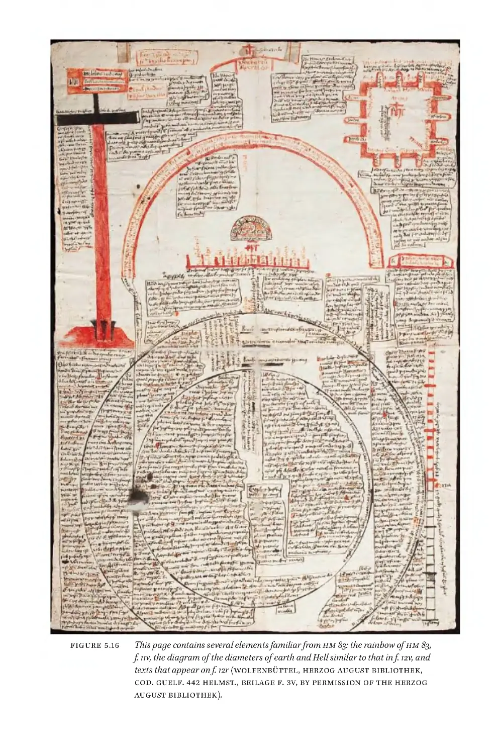
ProofofCirculation:Wolfenbüttel,HAB,Cod.Guelf.442Helmst 196
OtherAttemptstoMaptheApocalypse 218
Conclusions 233
Index 235
251
C onte nts
C onte nts
v
Acknowledgements
vii
Lis t
of
Fig ure s
v iii
In troduc tion
1
Chapter
1
4
Description
of
H unting ton
HM
83
4
1
ff
.
1r–8v
,
The
Brie f
Geographical
Treatise
6
2
ff
.
8v–12v
,
The
Treatise
on
the
Apocalypse
8
3
ff
.
13 r–1 8r
,
Heterogeneous
Section
on
As tron omy
and
Geography
9
4
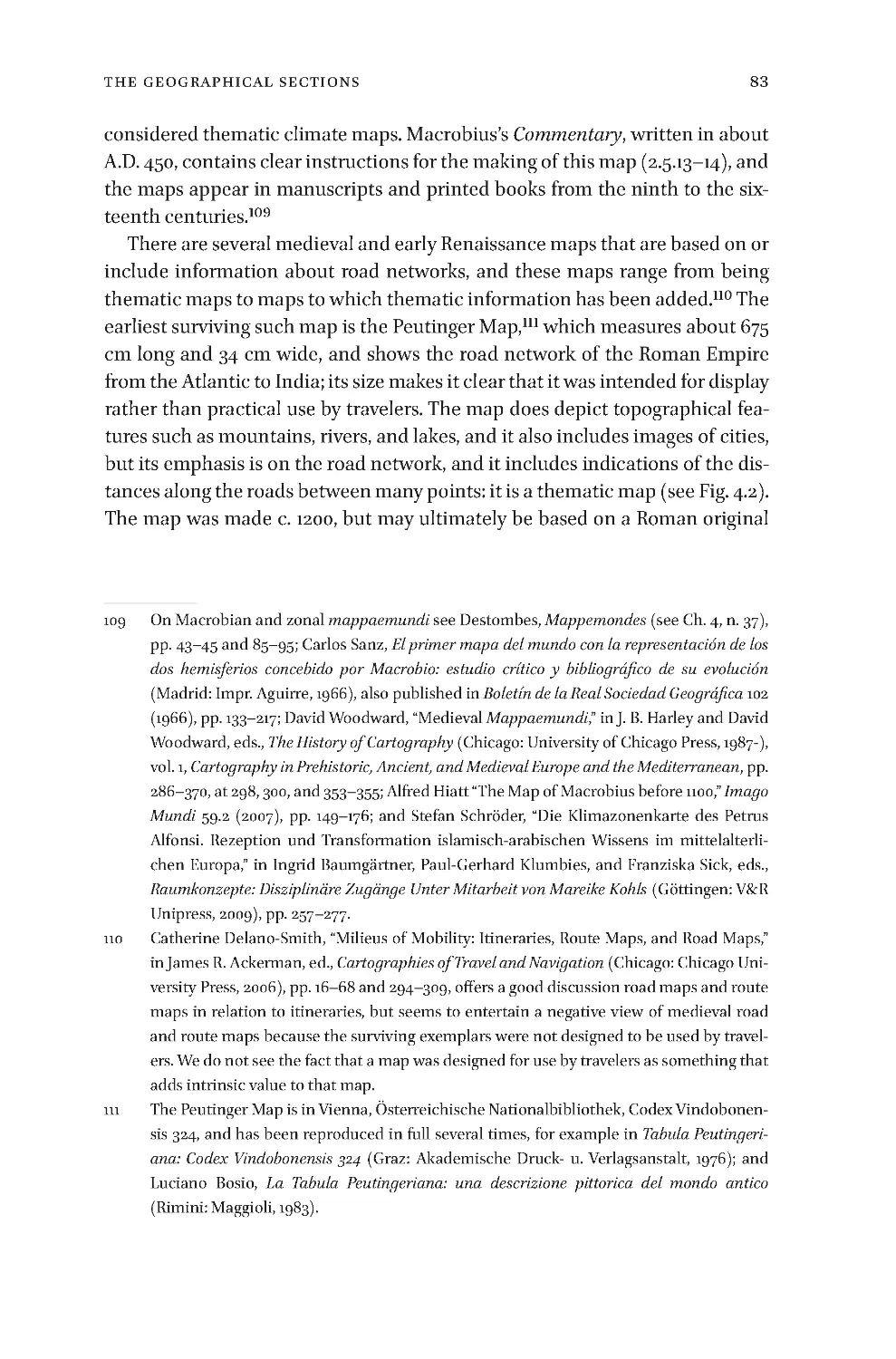
ff
.
19r–25v
,
Treatise
on
As tronom ica l
Me dic ine
10
Chapter
2
15
The
Historical
Context
:
Lübeck
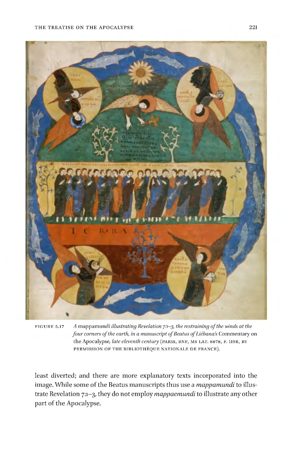
in
the
Fifteenth
Ce ntu ry
15
Chapter
3
21
The
Au thor
21
Chapter
4
29
The
Geographical
Sections
29
Excerpts
from
the
Geographical
Section
31
Excerpts
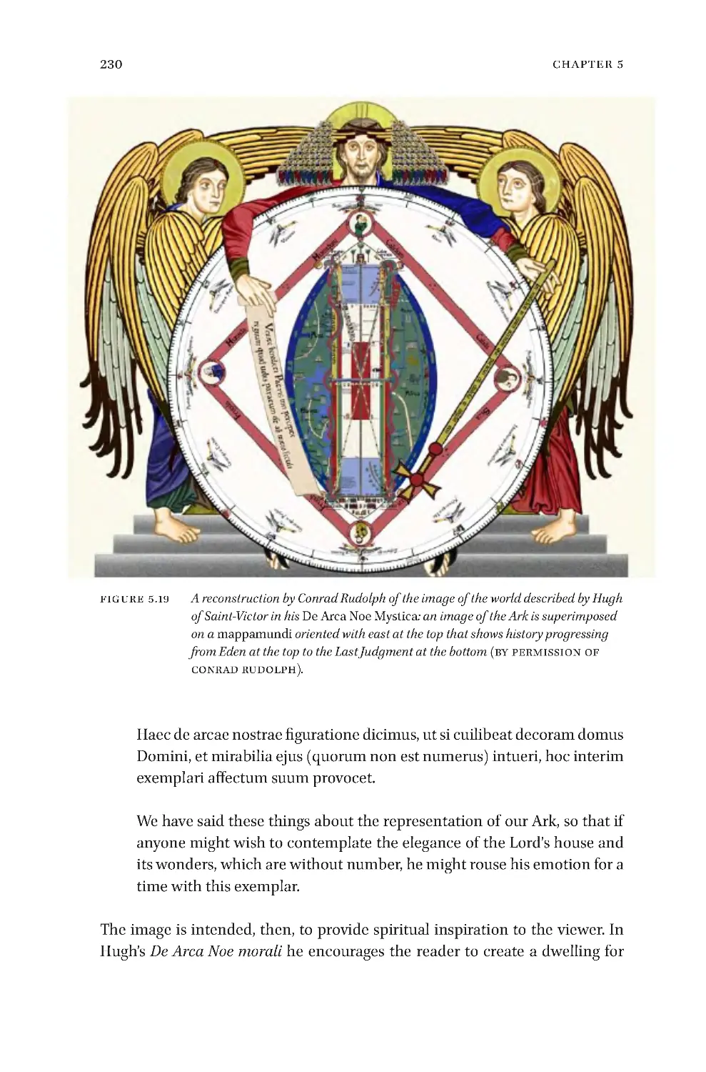
from
the
Section
on
As tr onomy
and
Geography
64
Link s
wit h
the
Rudime nt um
nov itior um
76
Early
Thematic
Ma ppi ng
80
The
Ma ps
in
the
Geographical
Sections
93
The
Map
on
f
.
1r 94
The
Map
on
f
.
3r 97
The
Ma ps
on
f
.
3v 100
The
Map
on
f
.
5r 102
The
Map
on
f
.
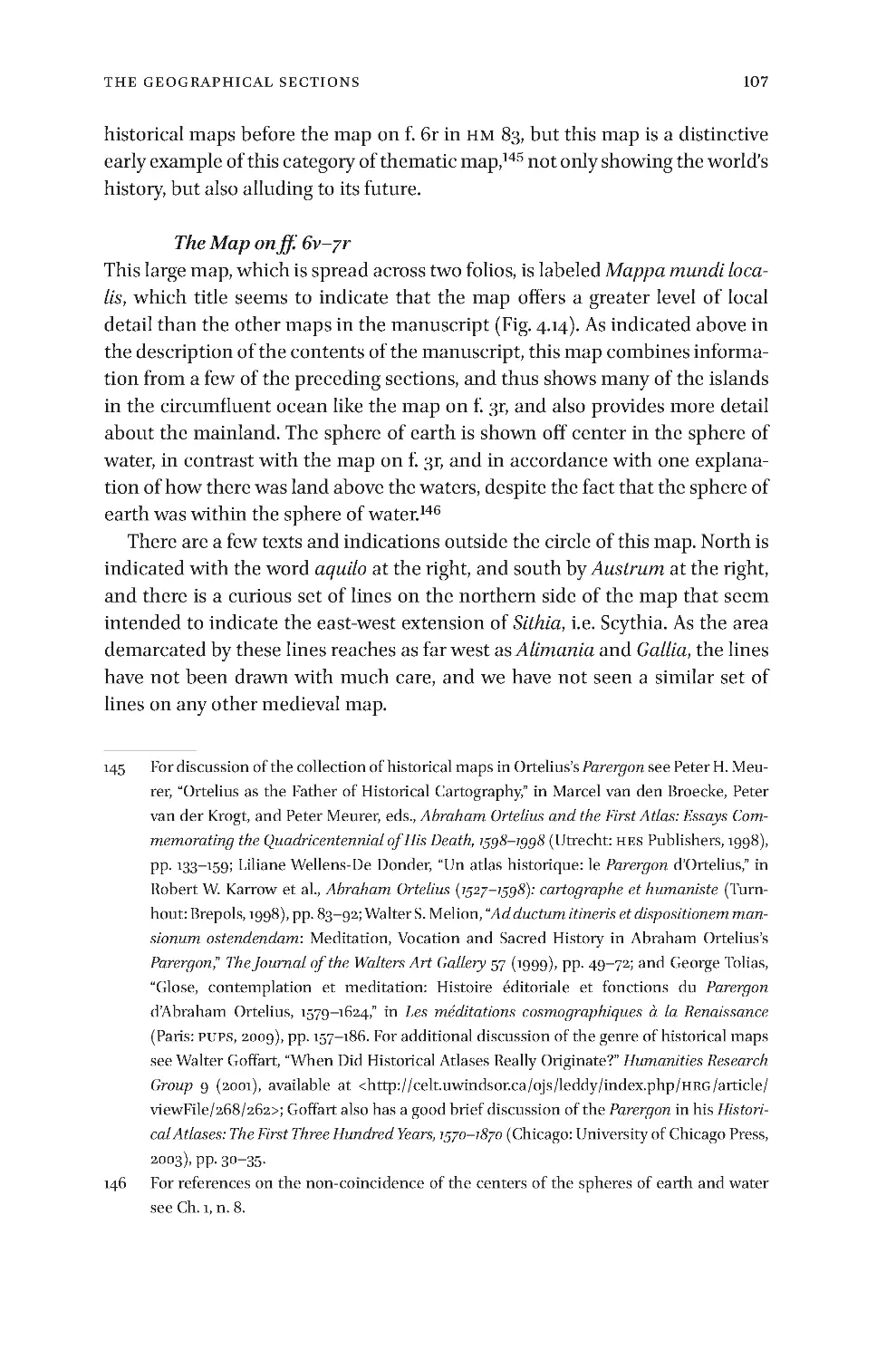
6r 105
The
Map
on
ff
.
6v–7r 107
The
Map
on
ff
.
7v–8r 111
The
Diagram
on
f
.
13r 116
The
Diagrams
on
f
.
13v 116
The
Map
on
f
.
14r 117
The
Map
on
f
.
14v 119
The
Map
on
f
.
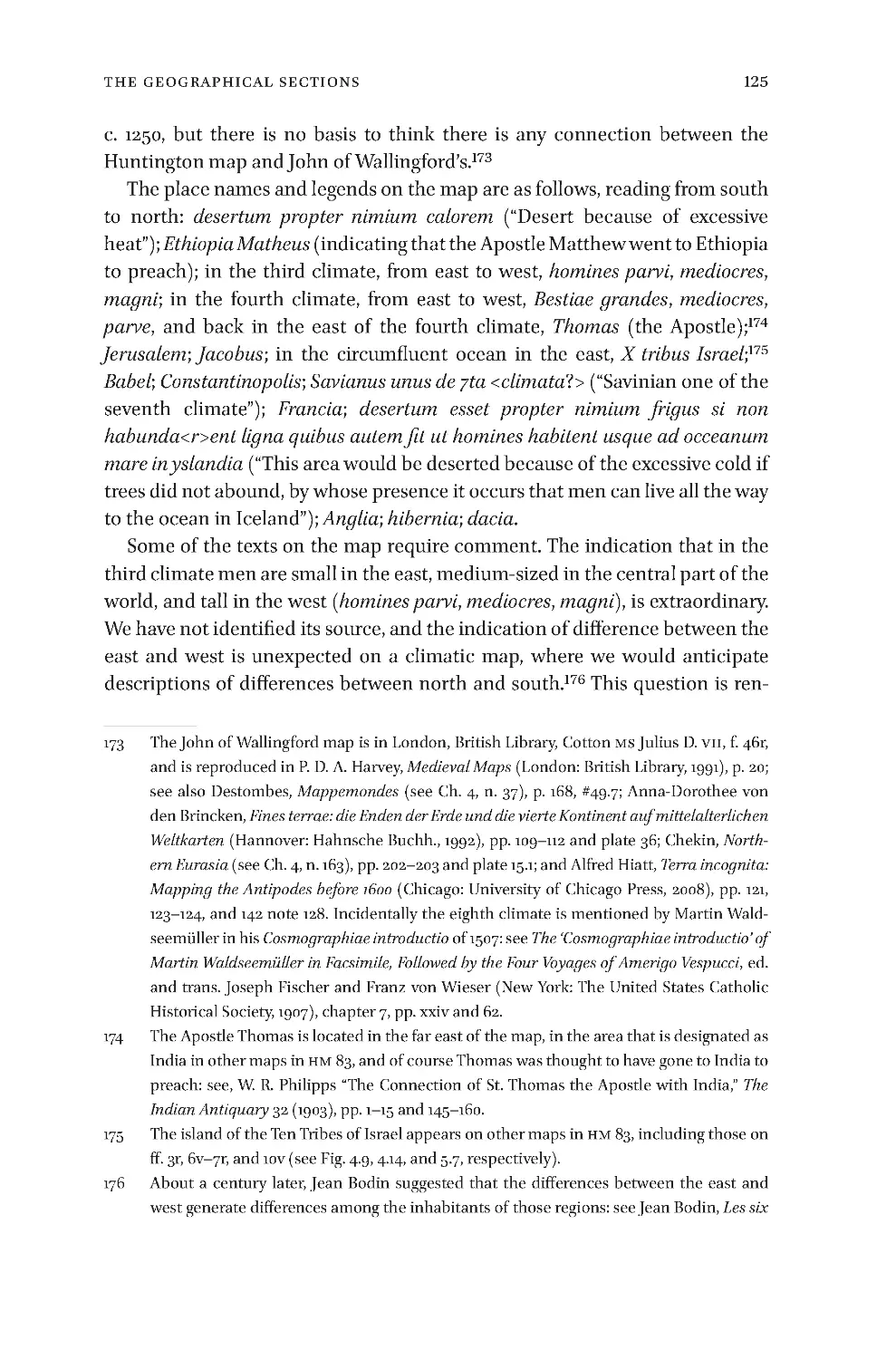
15r 121
Chapter
5
129
The
Treatise
on
the
Apocalypse
129
La te
Fifte e nth- Ce ntur y
German
Apocalypticism
135
The
A poca ly ptic
Ma ps
and
Texts
145
The
Map
and
Te xt
on
f
.
8v 147
The
Map
and
Te xt
on
f
.
9r 149
The
Map
and
Te xt
on
f
.
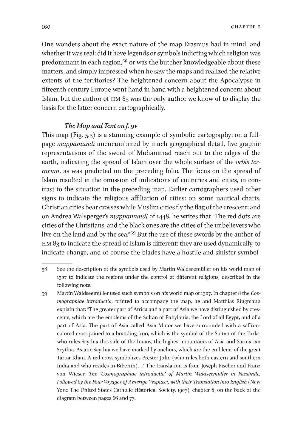
9v 160
The
Map
and
Te xt
on
f
.
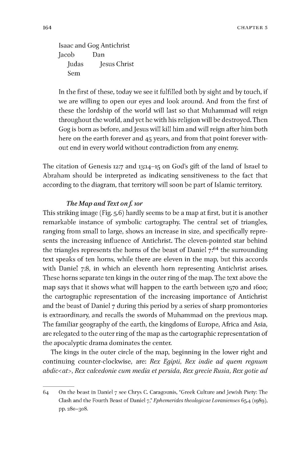
10r 164
The
Map
and
Te xt
on
f
.
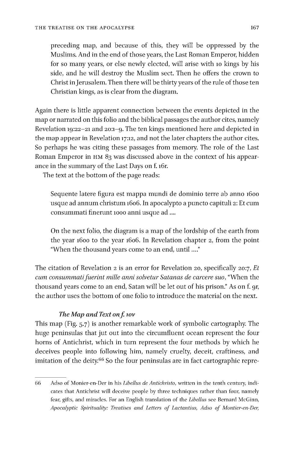
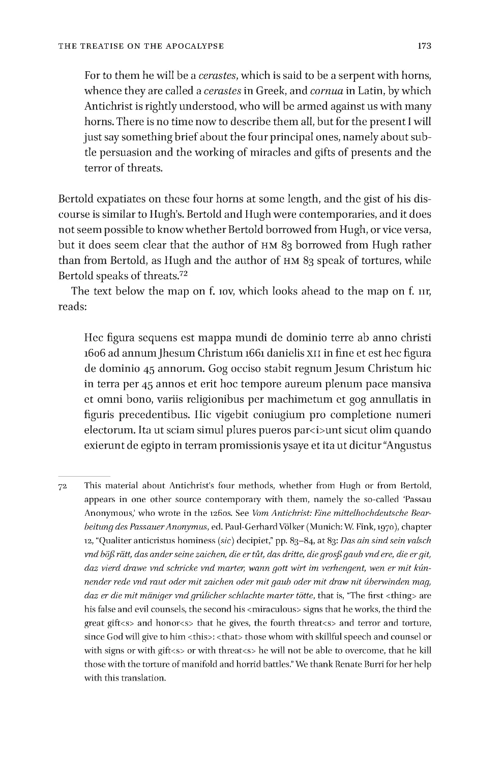
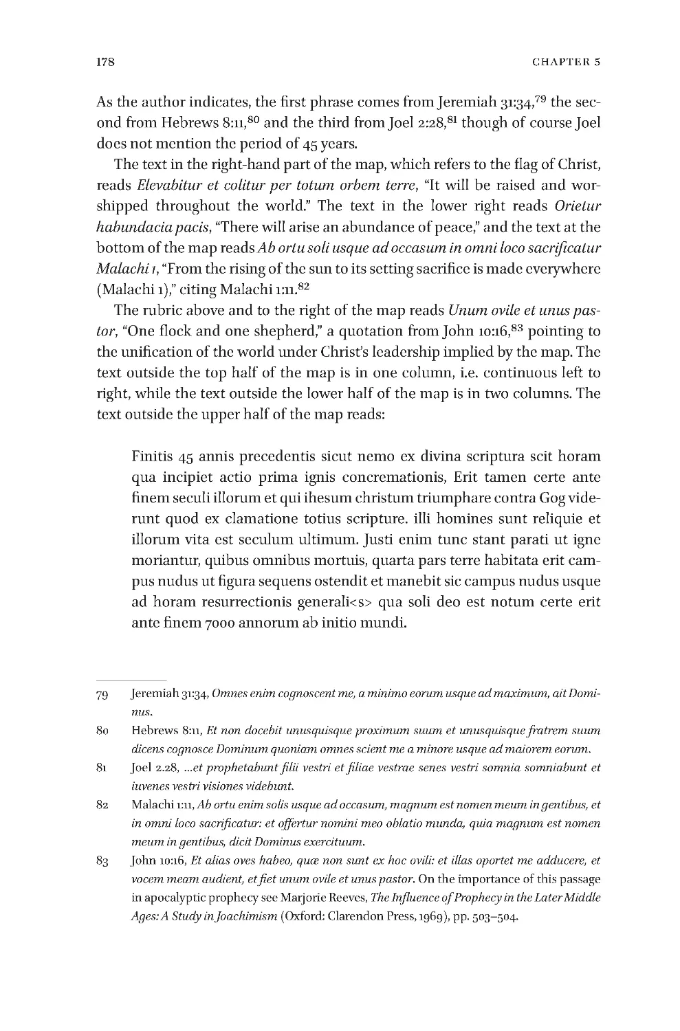
10v 167
The
Map
and
Te xt
on
f
.
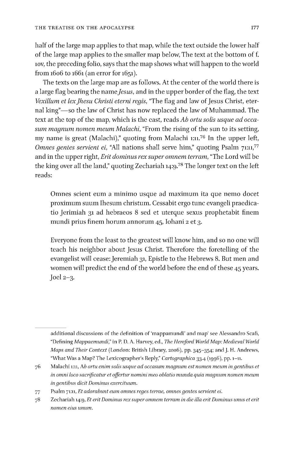
11r 175
The
Map
and
Te xt
on
f
.
11v 181
The
Map
and
Te xt
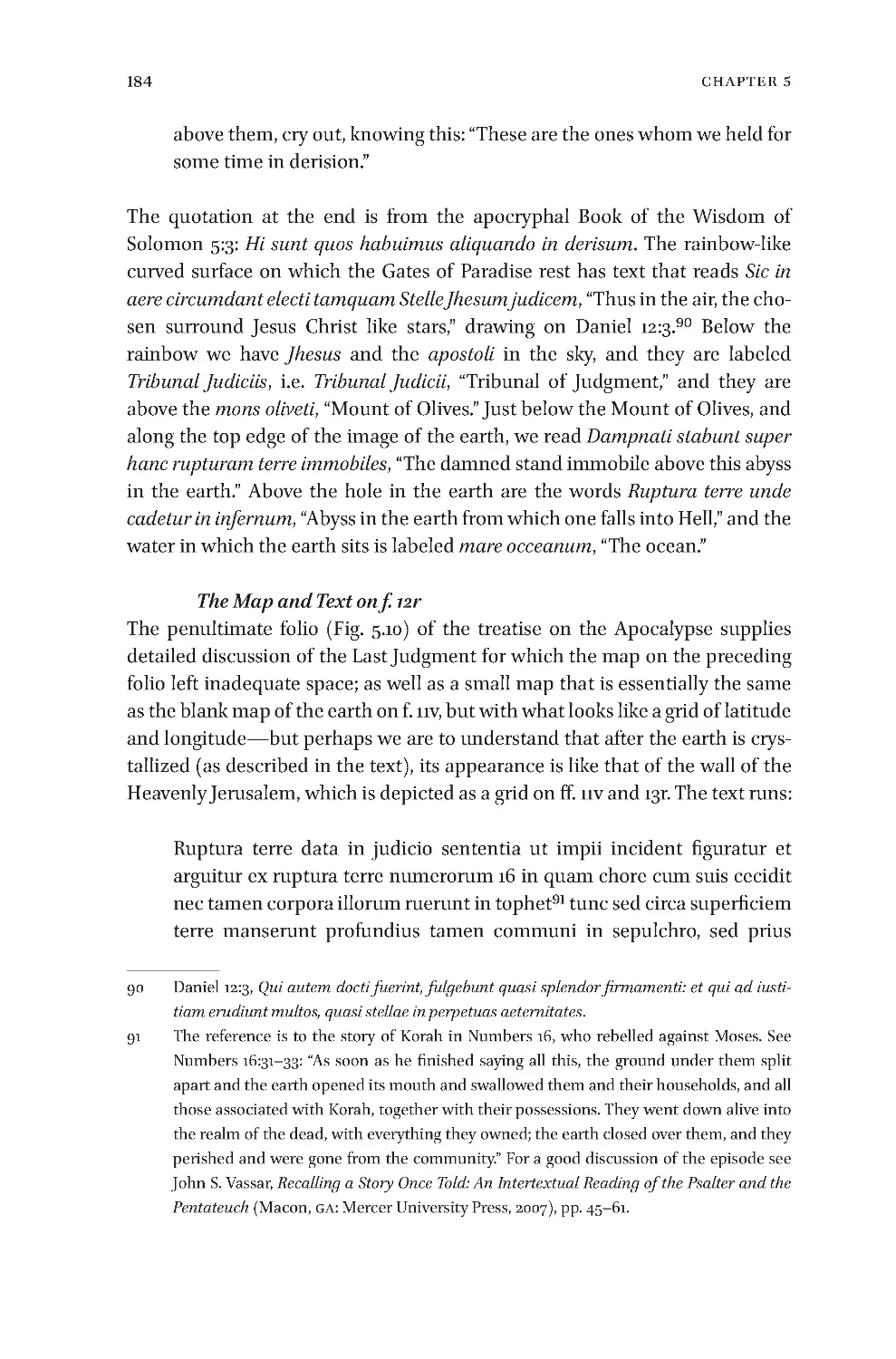
on
f
.
12r 184
The
Map
and
Te xt
on
f
.
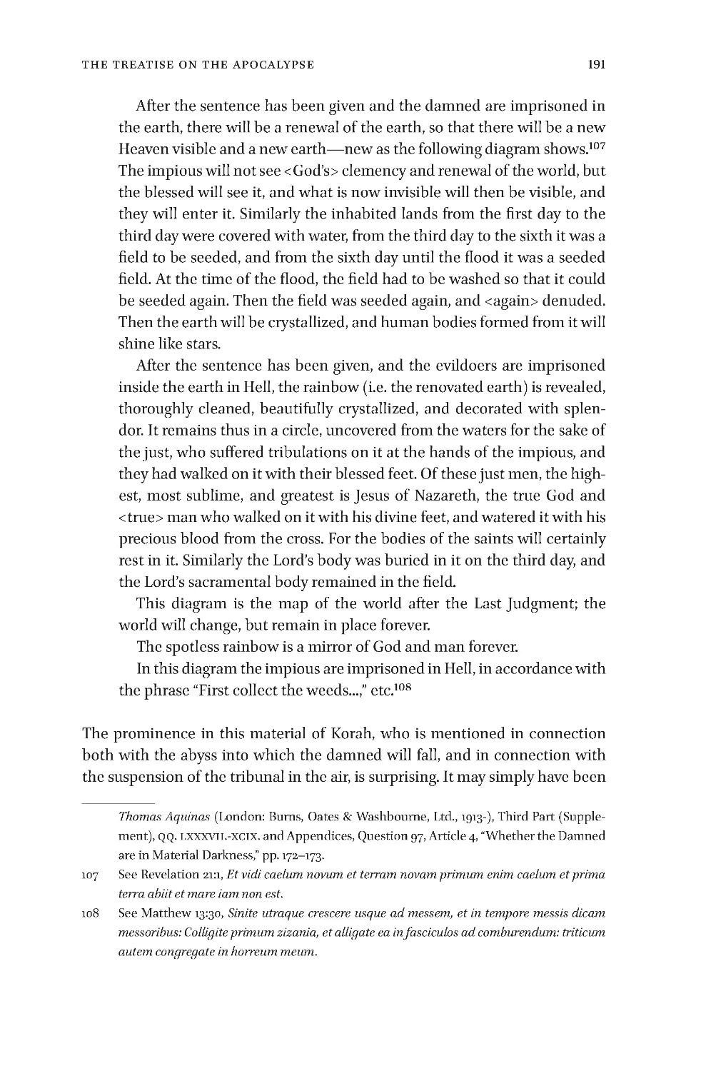
12v 192
Pr oof
of
Cir cul at ion
:
W olfe nbütte l
,
HAB
,
Cod
.
Gue lf
.
442
Helmst
.
196
Beilage
f
.
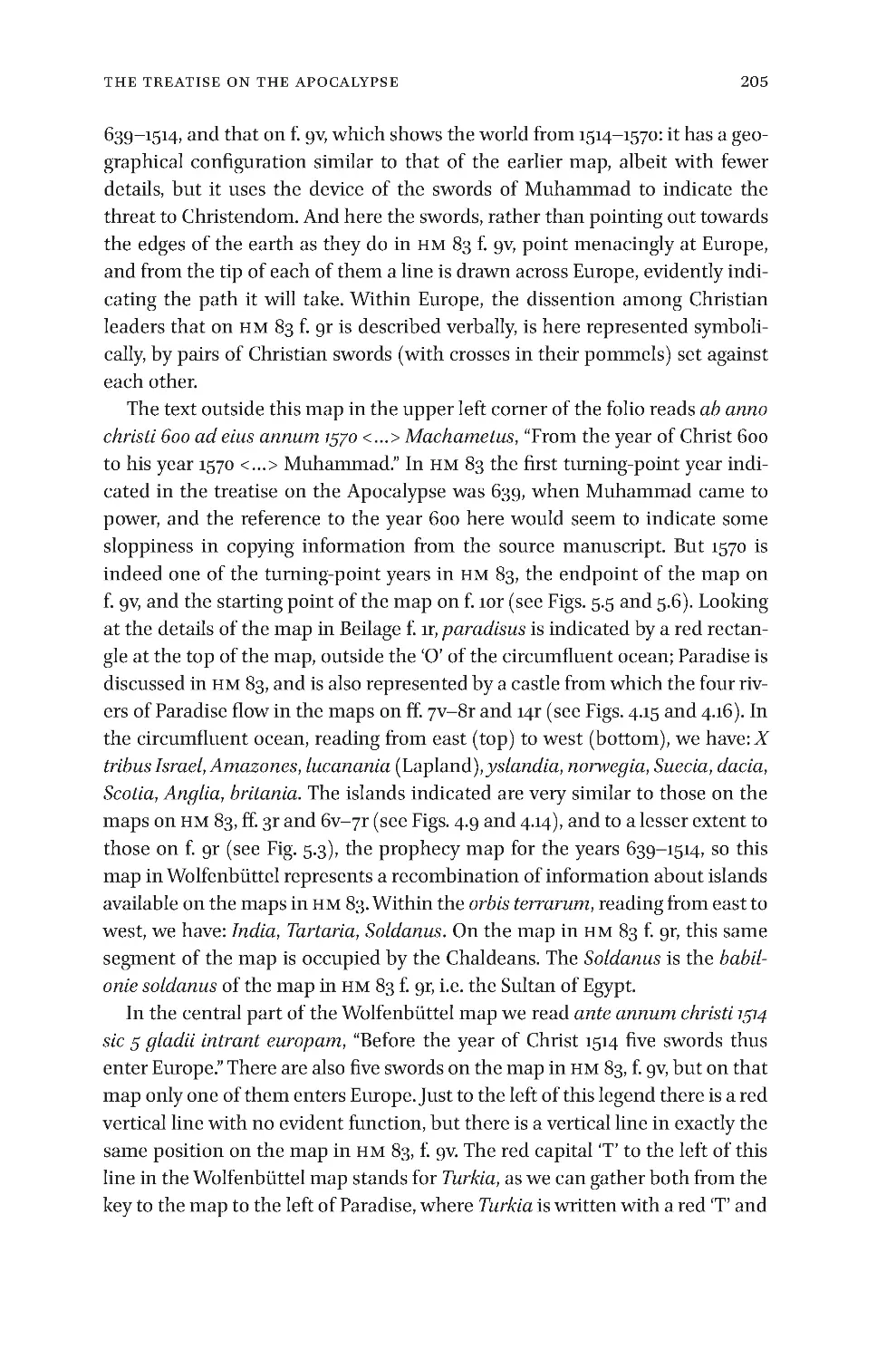
1r 203
Beilage
f
.
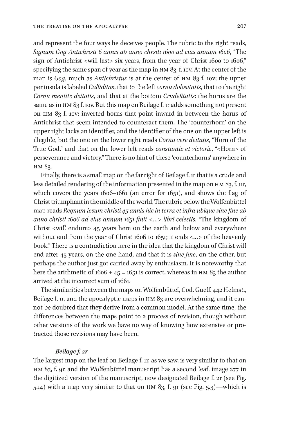
2r 207
Beilage
f
.
2v 209
Beilage
f
.
3r 209
Beilage
f
.
3v 210
Other
Attempts
to
Map
the
Apocalypse
218
C onclu sions
233
In dex
235
vi
Contents
vii
Acknowledgements
Acknowledgements
Acknowledgements
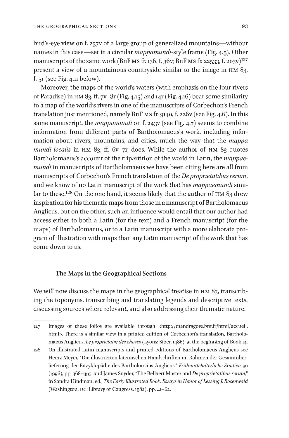
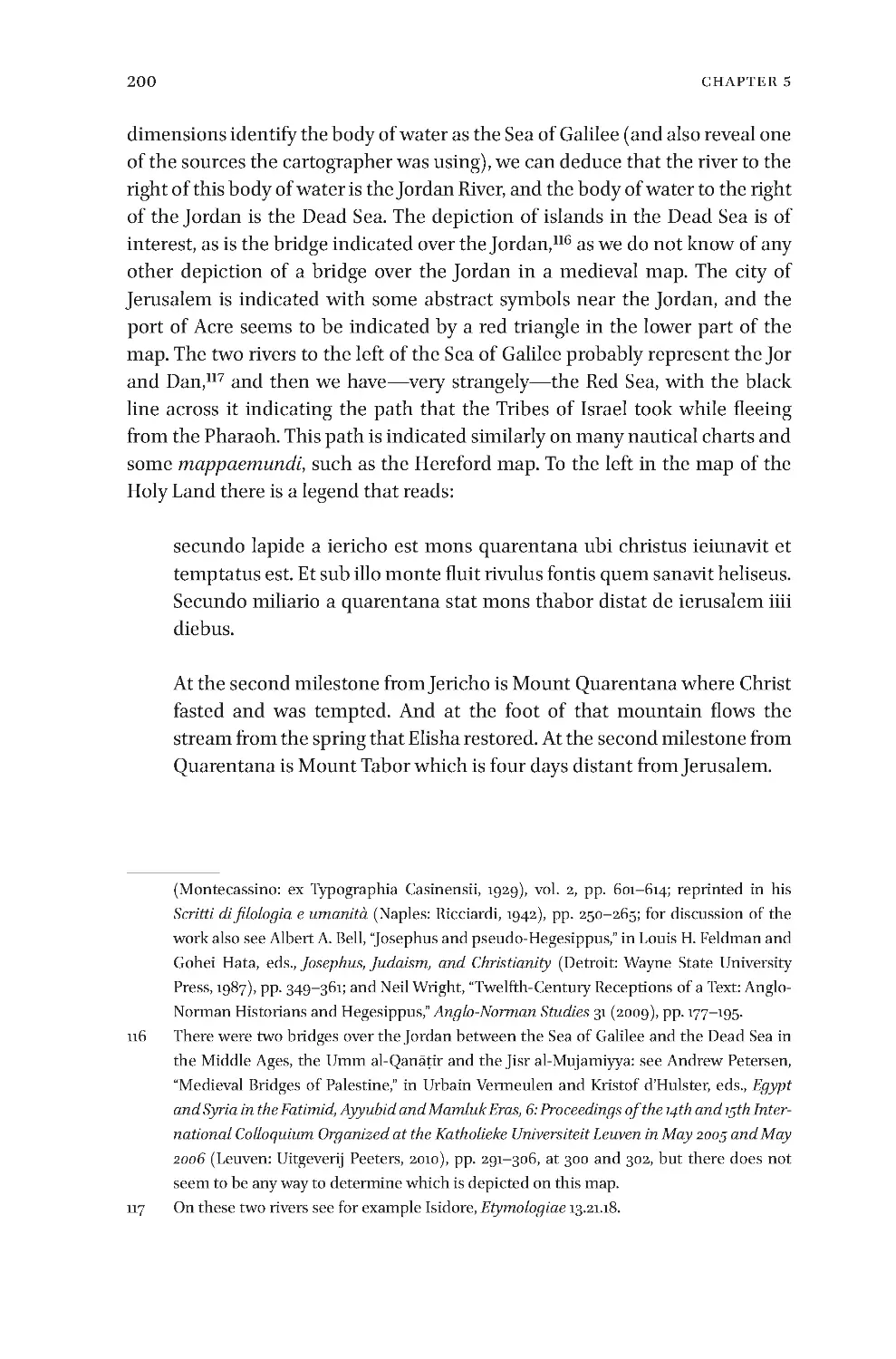
One of the authors(Van Duzer)had had digital images of the curious maps
fromHuntingtonLibraryHM83onhiscomputerfor someyears, meaningto
findanopportunitytostudythem,wheninlate2011hereceivedanannounce-
mentoftheconference“ChartingtheFutureandtheUnknownintheMiddle
AgesandRenaissance,”tobeheldatBarnardCollegeinNewYorkinDecember
of 2012.A proposal to present apaper titled “Mapping the End oftheEarth:
ApocalypticMappaemundiinaFifteenth-CenturyManuscript”attheconfer-
encewasaccepted,anditwastheresearchdoneinpreparationforgivingthat
paper, and the positive reception of the paper at the conference, that made
him appreciate just how rich and important the Huntington manuscript is.
OurthankstoPhillipJohnUsherfororganizingtheconferenceatBarnard.
Oursubsequentworktogetherintranscribingandunderstandingthetexts
inthemanuscript—conductedduringlongSkypecallsbetweenCaliforniaand
Jerusalem—went very smoothly, though it was laced with some choice re-
marksaboutthehandwritingofthescribeswhowroteHM83.Wewishother
authors working together as positive and enjoyable a collaborative relation-
ship.
Wegive our enthusiastic thanks toLauraSmoller,NataliaLozovsky,Bene-
dicteGamborgBriså,AmnonLinder,LeonidChekin,FelicitasSchmieder,and
BarryHinmanforreadingadraftofthisbookandgivingustheirsuggestions
andcomments.
Chet Van Duzer
LosAltosHills,CA,2015
Ilya Dines
Washington,DC,2015
viii
ListOfFigures
ListofFigures
List of Figures
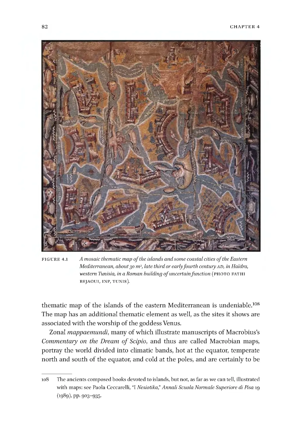
4.1 MosaicmapoftheislandsoftheEasternMediterranean,latethirdorearly
fourthcenturyAD,inHaïdra,westernTunisia 82
4.2 DetailofthePeutingerMap,Vienna,ÖsterreichischeNationalbibliothek,Codex
Vindobonensis324,segment1 84
4.3 MapofCyprusinBartolommeodaliSonetti’sIsolariopublishedinVenice
c.1485(LibraryofCongress) 88
4.4 Unfinishedmapoftheworld’smountains,latefifteenthcentury,inParis,BnF,
MSfr.22532,f.186v 90
4.5 Mapoftheworld’smountains,c.1480,inParis,BnF,MSfr.9140,f.237v 91
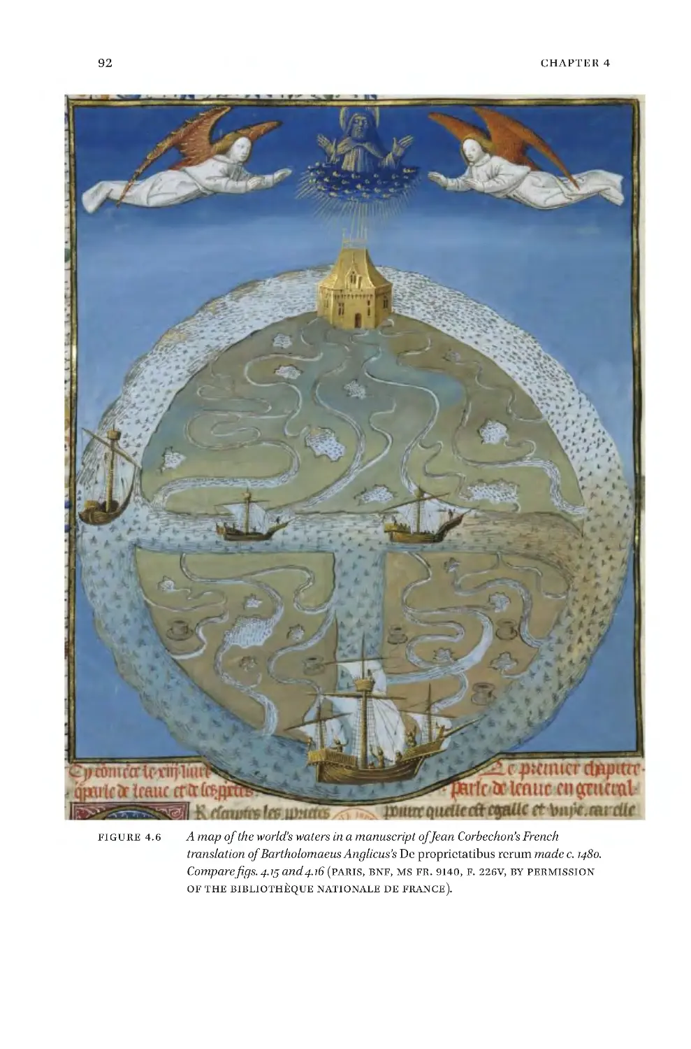
4.6 Mapoftheworld’swaters,c.1480,inParis,BnF,MSfr.9140,f.226v 92
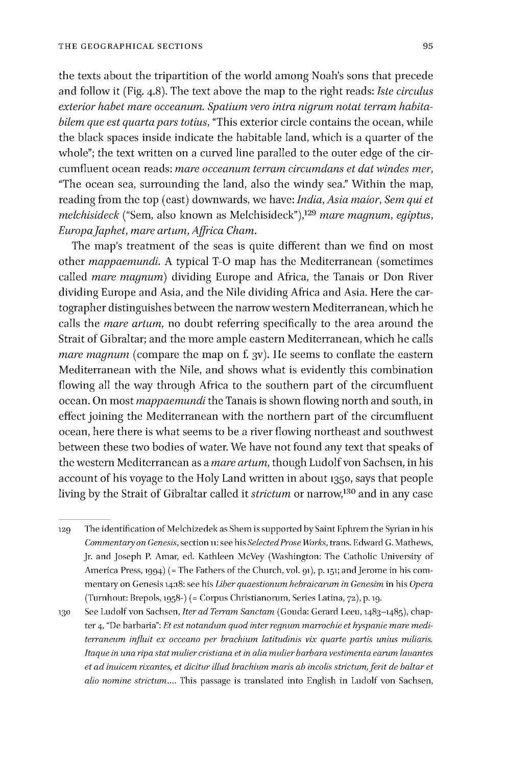
4.7 Mappamundithatcombinesinformationaboutrivers,mountains,andcities,
c.1480,inParis,BnF,MSfr.9140,f.243v 94
4.8 HuntingtonHM83,f.1r,theopeningofthetreatiseongeography 96
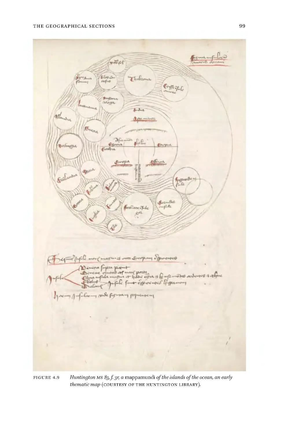
4.9 HuntingtonMS83,f.3r,mappamundioftheislandsoftheocean 99
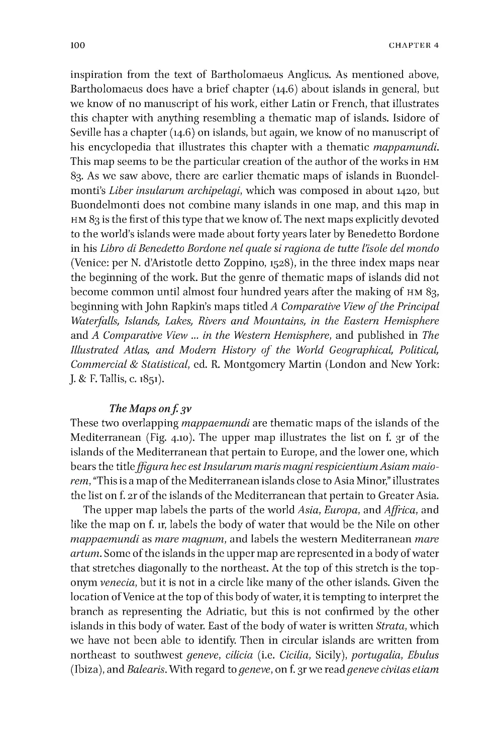
4.10 HuntingtonHM83,f.3v,mapsofEuropeanandAsianislands 101
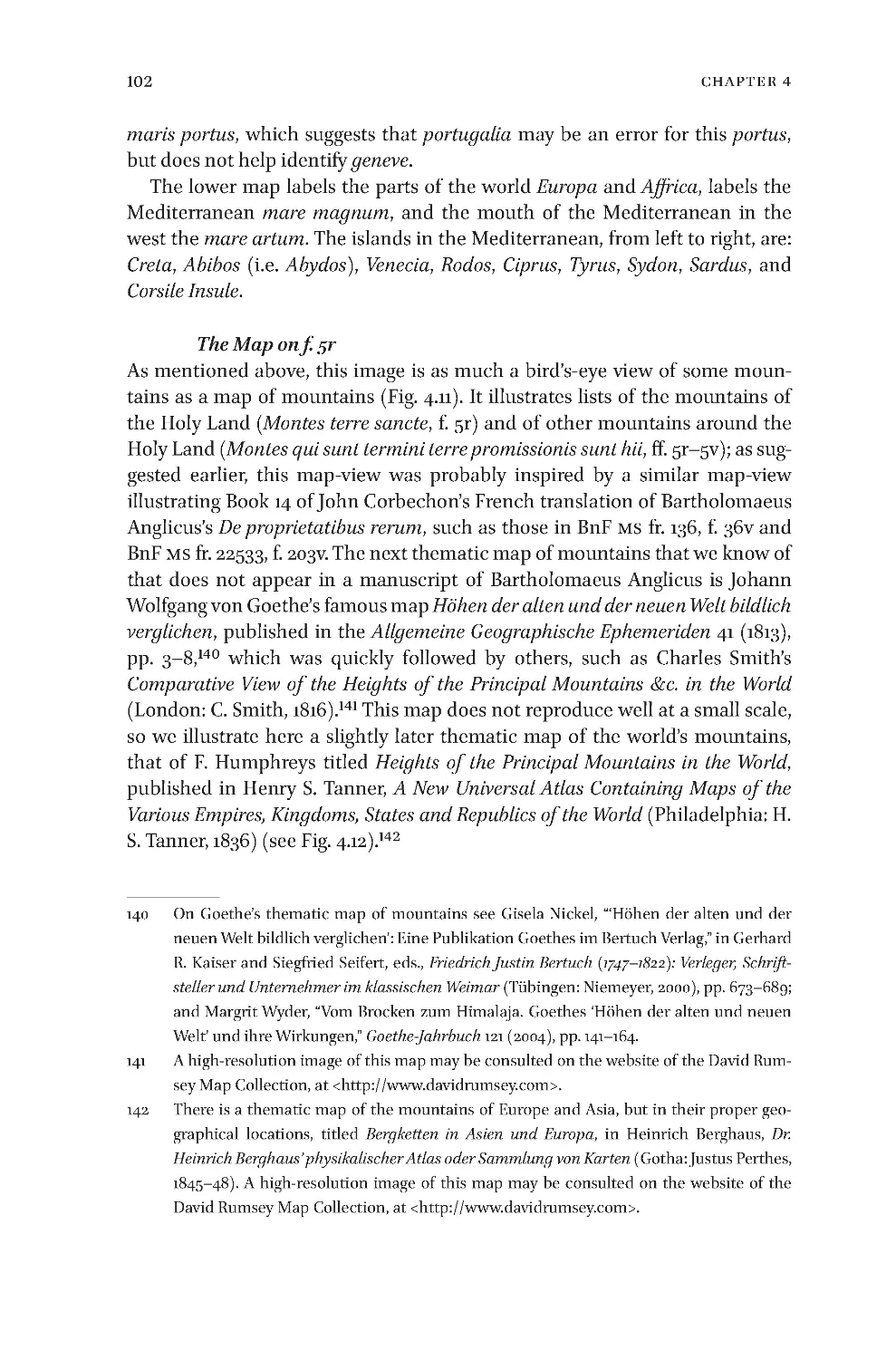
4.11 HuntingtonHM83,f.5r.Agenericviewofsomemountains,followedbyalistof
themountainsoftheHolyLand,andthenalistofmountainsoutsidetheHoly
Land 103
4.12 F.Humphreys,Heights of the Principal Mountains in the World,publishedin
HenryS.Tanner,A New Universal Atlas Containing Maps of the Various Empires,
Kingdoms, States and Republics of the World(Philadelphia:H.S.Tanner,
1836) 104
4.13 HuntingtonMS83,f.6r,listofthelandsinwhichtheApostlespreachedand
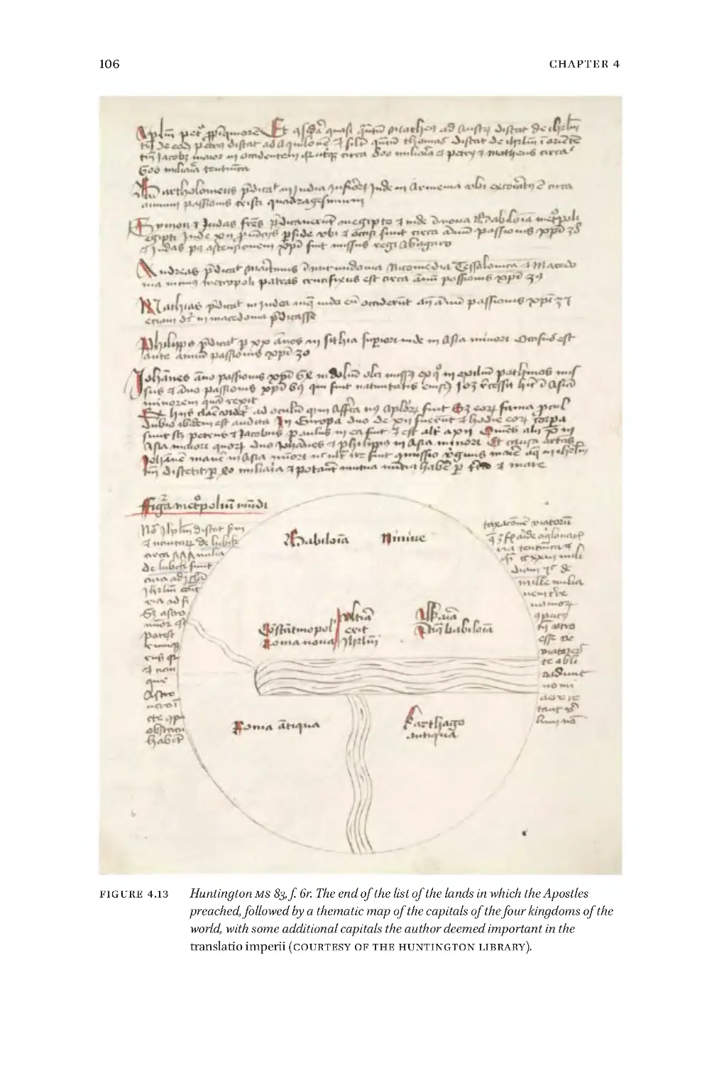
mapofthecapitalsofthefourkingdomsoftheworld 106
4.14 HuntingtonMS83,ff.6v–7r,alargedetailedmappamundi 108–109
4.15 HuntingtonMS83,ff.7v–8r,alargemapofthewatersoftheworld 112
4.16 HuntingtonMS83,f.14r,mapoftenclimaticzonesandthewatersofthe
earth 118
4.17 HuntingtonMS83,f.14v,mapofnineclimaticzones 120
4.18 HuntingtonMS83,f.15r,mapshowingsevenclimaticzonesandwherethe
Apostlespreached 122
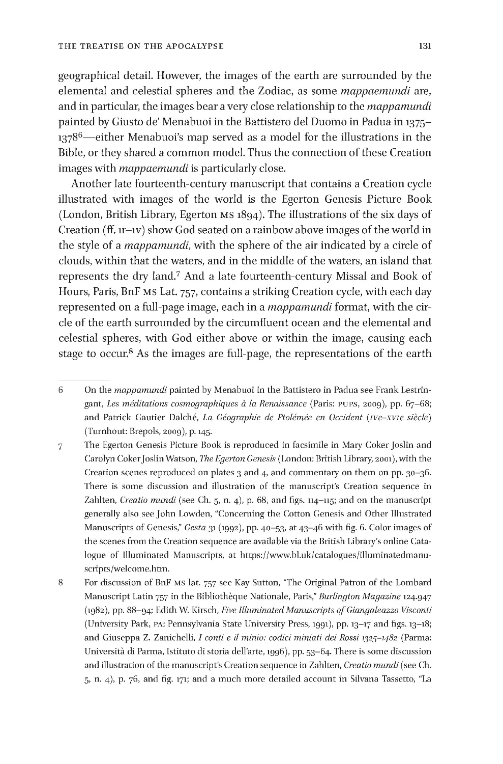
5.1 TheCreationsequenceinamanuscriptofCorbechon’sFrenchtranslationof
BartholomaeusAnglicus’sDe proprietatibus rerum,c.1400,inMadrid,
FundaciónLázaroGaldiano,MSI15554,f.16v 134
5.2 HuntingtonHM83,f.8v,textdescribingthefourdifferentfunctionsofa
mappamundiandasimplemapshowingtheworldfromthebirthofChristto
theyear639 148
ix
ListofFigures
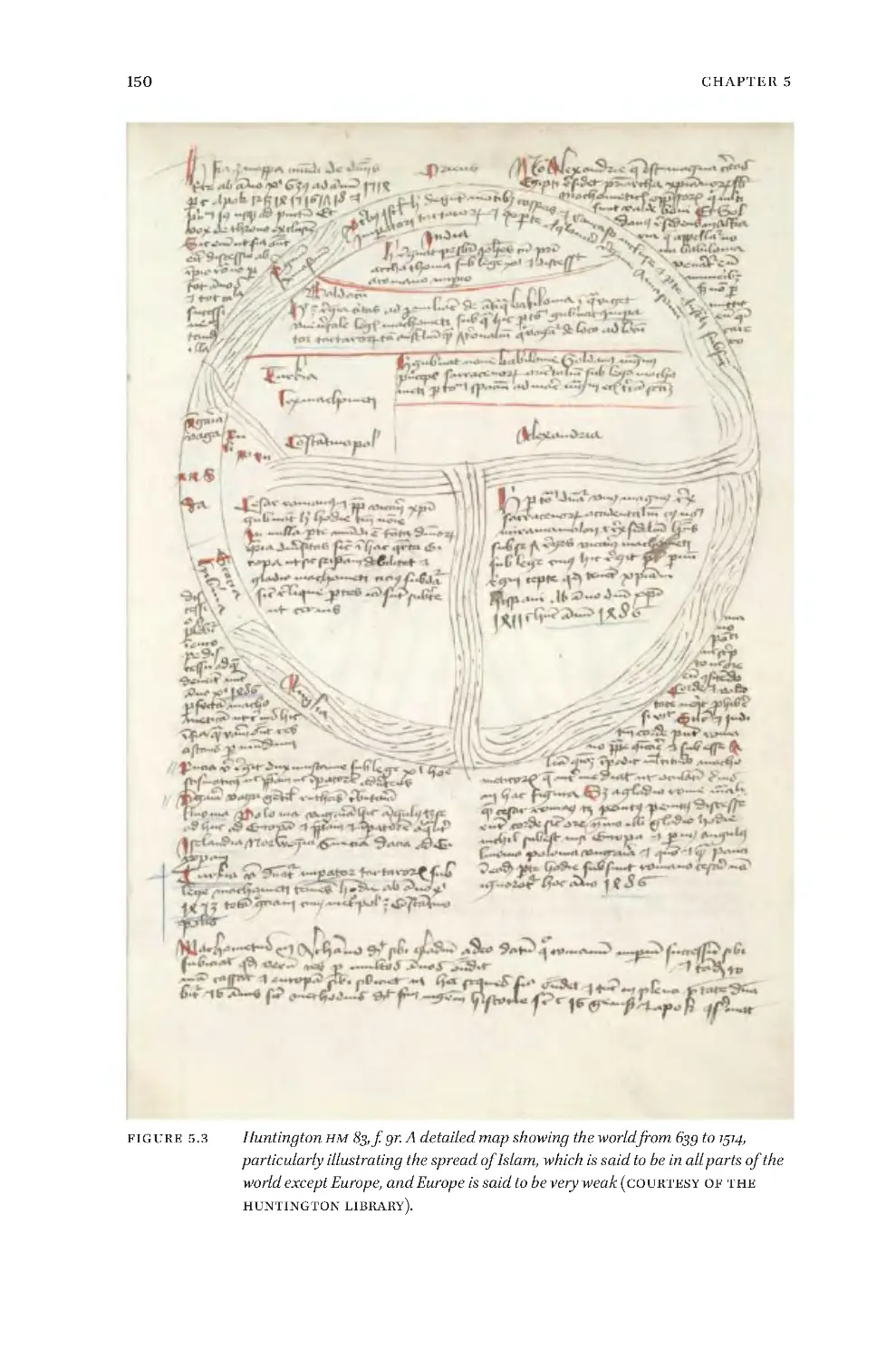
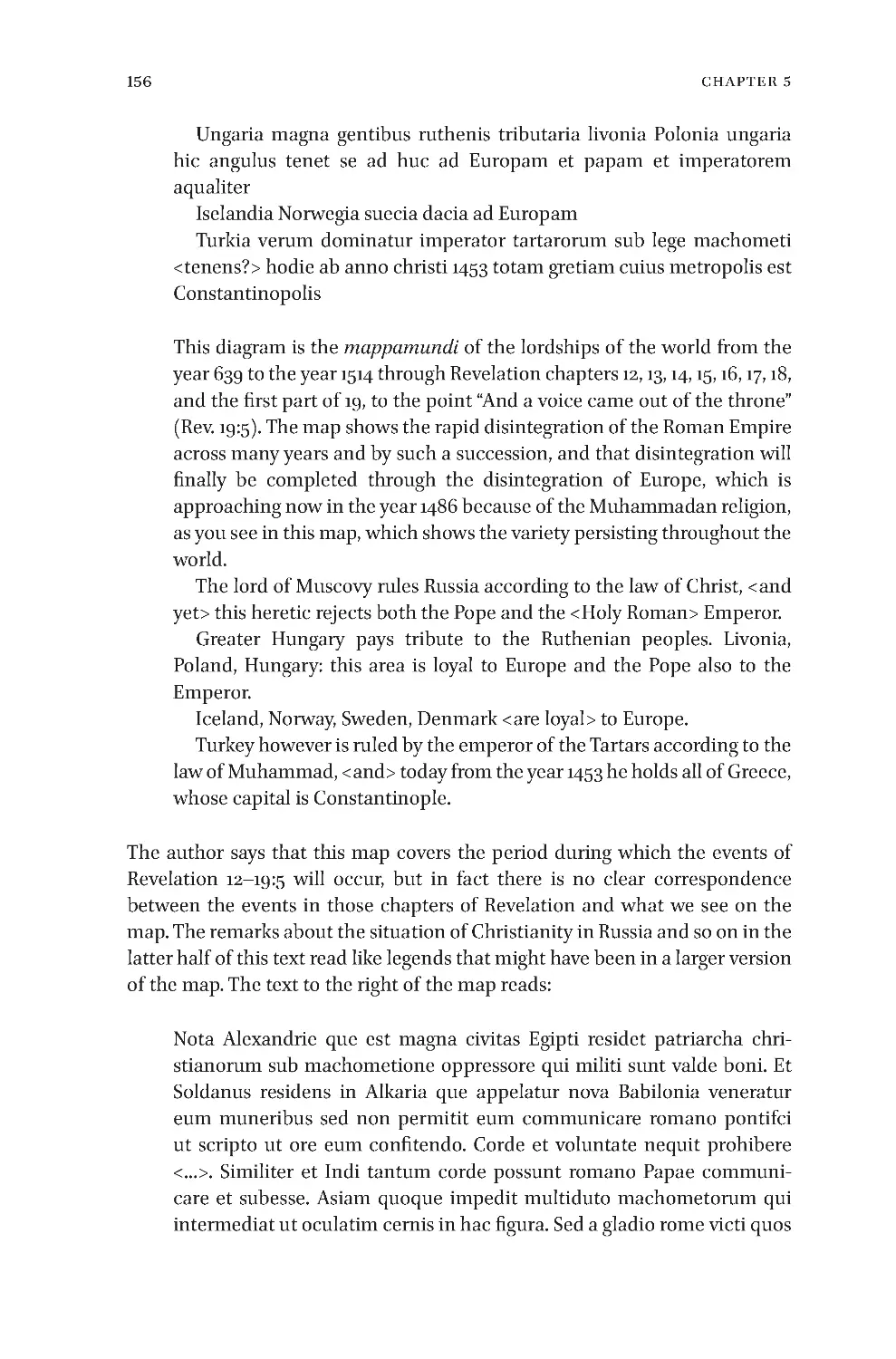
5.3 HuntingtonHM83,f.9r,mapshowingtheworldfrom639to1514 150
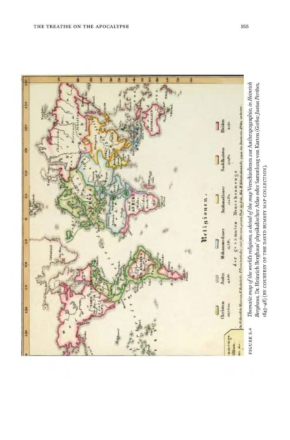
5.4 Thematicmapoftheworld’sreligionsfromDr. Heinrich Berghaus’
physikalischer Atlas oder Sammlung von Karten(Gotha:JustusPerthes,1845–
48) 155
5.5 HuntingtonHM83,f.9v,prophecymapshowingtheworldfrom1514to
1570 161
5.6 HuntingtonHM83,f.10r,prophecymapshowingtheworldfrom1570to
1600 165
5.7 HuntingtonHM83,f.10v,prophecymapoftheworldfrom1600to1606 168
5.8 HuntingtonHM83,f.11r,prophecymapoftheworldfrom1606to1661
(amistakefor1651) 176
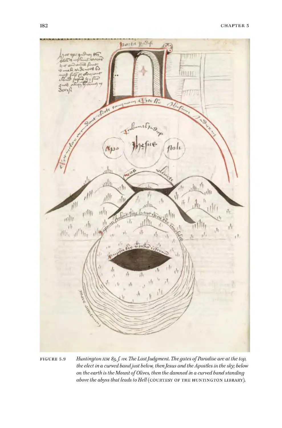
5.9 HuntingtonHM83,f.11v,theLastJudgment 182
5.10 HuntingtonHM83,f.12r,textontheLastJudgmentandsmallmapofa
featurelessearthaftertheLastJudgment 185
5.11 HuntingtonHM83,f.12v,diagramoftherelativediametersoftheearthand
Hell 193
5.12 MapsoftheHolyLandandoftheworldinWolfenbüttel,HerzogAugust
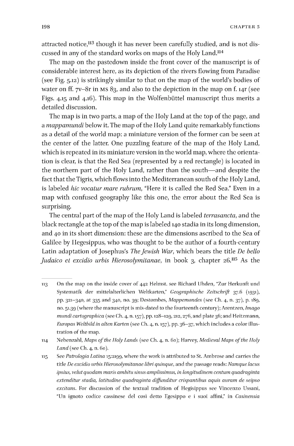
Bibliothek,Cod.Guelf.442Helmst.,Vorderseite 199
5.13 FourapocalypticmappaemundiinWolfenbüttel,HerzogAugustBibliothek,
Cod.Guelf.442Helmst.,Beilagef.1r 204
5.14 MappamundisimilartoHuntingtonHM83,f.9r,inWolfenbüttel,Herzog
AugustBibliothek,Cod.Guelf.442Helmst.,Beilagef.2r 208
5.15 MappamundisimilartoHuntingtonHM83,f.10r,inWolfenbüttel,Herzog
AugustBibliothek,Cod.Guelf.442Helmst.,Beilagef.2v 210
5.16 FoliowithelementssimilartothoseinHM83,ff.11v,12r,and12v,in
Wolfenbüttel,HerzogAugustBibliothek,Cod.Guelf.442Helmst.,Beilagef.
3v 212
5.17 MappamundiillustratingRevelation7:1–3inamanuscriptofBeatusof
Liébana’sCommentary on the Apocalypse,lateeleventhcentury,inParis,BnF,
MSlat.8878,f.119r 221
5.18 NortheasternAsiaontheCatalanAtlasof1375,Paris,BnF,MSEspagnol30 226
5.19 ConradRudolph’sreconstructionoftheimageoftheworlddescribedbyHugh
ofSaint-VictorinhisDe Arca Noe Mystica 230
x
ListOfFigures
1
Introduction
Introduction
Introduction
Inthisbookweofferadetailedanalysisofthemapsandsomeofthetextinan
unusualandunstudiedfifteenth-centurymanuscript,SanMarino,Huntington
Library MS HM 83, which contains interrelated texts composed in 1486–88,
almostcertainlyinLübeck,Germany.Themanuscriptconsistsoffourparts:a
briefgeographicaltreatiseillustratedwithmaps(ff. 1r–8r);aconcise account
oftheApocalypse,alsoillustratedwithmaps(ff.8v–12v);asomewhathetero-
geneous section with material on astronomy and geography, also illustrated
with maps (ff. 13r–18r); and a collection of texts on astrological medicine
(ff.19r–25v).
Themanuscriptisofsignificancebothforthehistoryofcartographyandfor
thehistoryofApocalypticism.Itcontainswhatisbyfarthelargestcollection
ofmappaemundiinanyonemanuscript,andalsotheearliestsetsofthematic
maps, or maps thatfocus on a specific theme.Everystudyofthematic maps
thatwehaveconsultedindicatesthatthisgenredidnotexistbeforetheseven-
teenthcentury,butinfactmapsthatcanandshouldbeidentifiedasthematic
wereproduced hundreds ofyearsbefore that period, as we willshow below.
The mapsin theHuntington manuscript are not the earliest thematic maps,
butthemanuscriptcontainstheearliestsetsofsuchmapsthatseemtohave
been produced in accordance with the modern understanding of the genre,
and thus represent a remarkable achievement in the history of mapmaking,
albeit one that had a verylimited influence.The manuscript also contains a
passageaboutthedifferentfunctionsofmapsthatisuniqueinfifteenth-cen-
turycartographicalwritings,andconfirmsthattheanonymousauthorhadan
essentiallymodernunderstandingofthematicmapsasagenre.
ThereareintriguingconnectionsbetweentheHuntingtonmanuscriptand
anotherworkproducedinLübeckafewyearsearlier:theRudimentum novitio-
rum,whichwasprintedbyLucasBrandisin1475.TheRudimentumcontainsa
world map and a map of the Holy Land, both accompanied by extensive
descriptivetexts.TherearemanydifferencesbetweentheHuntingtonmanu-
scriptandtheRudimentum,mostnotablydifferencesofpurposeandtone,and
therearealso significantdifferencesbetween the mapscontainedin the two
works,butthereareenoughconnections—whichwillbedetailedbelow—to
suggestsomedegreeofinfluenceoftheprintedworkonthemanuscriptone.
The use of maps to illustrate what will happen to the earth during the
Last Days in HM 83 not only creates a very distinctive, original, and striking
© koninklijkebrillnv,leiden,2016 | doi10.1163/9789004307278_002
2
Introduction
iconographical program for the Apocalypse,1 but also involves an unusual
meldingofthesymbolicandcartographic.Theauthorboldlymapsthefuture
transformationstheworldwillundergo,includingtworemarkablemapsofthe
earthdevoidofallphysicalfeaturesfollowingtheApocalypse(ff.11rand12r).
Themanuscriptisofsignalinterestforitsinnovativeexplorationofwhatcan
bedonewithmapsinthefifteenthcentury.Studyoftheapocalypticsectionof
the manuscript reveals the mosaic of different sources that the anonymous
authorused,andoneofhismapsisacartographicinterpretationofapassage
in the Compendium theologiae or Compendium theologicae veritatis by Hugh
RipelinofStrasbourg(c.1205–c.1270).Thereisastronganti-Islamicstrainin
theapocalypticsectionofthemanuscript,andtheanonymousauthoradopts
a belief that goes back to John of Damascus (c. 645 or 676–749)2 that
MuhammadwasaprecursorofAntichrist.Theauthoralsoinvokesthelegend
of the Last Emperor, which was initially promulgated in the Apocalypse of
pseudo-Methodius;3althoughtheauthorcitesMethodiusonf.9rofthemanu-
script,heseemstohavemadelittleornodirectuseofthattext.Wehavenot
been able to determine the sources of all of the parts of the manuscript’s
uniquechronologyoftheApocalypse,butsomepartsarebasedontheauthor’s
interpretationofreferencestodaysinvariouspassagesintheBibleasindicat-
ing years, no doubt inspired, like so many other interpreters of biblical
chronology,byaphrasein2Peter3:8, “WiththeLordadayislikeathousand
years,andathousandyearsarelikeaday.”Thisbookbeginswithadiscussion
ofthemanuscriptanditshistoricalcontext,whichisfollowedbydetaileddis-
cussion of the geographical sections, together with analysis of their maps.
1 For a detailed list of other manuscripts that contain illustrations of the Apocalypse see
Richard Kenneth Emmerson and Suz anne Lewis, “Census and Bibliography of Medieval
ManuscriptsContainingApocalypseIllustrations, ca.800–1500,”Traditio40(1984),pp.337–
379;41(1985),pp.367–409;and42(1986),pp.443–472.Forchaptersthattogetherformagood
discussion ofartbasedonthe Apocalypse seeRichardK.Emmerson andBernardMcGinn,
eds.,The Apocalypse in the Middle Ages(Ithaca, N Y: Cornell University Press, 1992), part 2,
pp.103–289.
2 SeeJohnW.Voorhis,“JohnofDamascusontheMoslemHeresy,”The Muslim World24.4(1934),
pp.391–398;SaintJohnofDamascus,Writings: The Fount of Knowledge(NewYork:Fathersof
theChurch,1958)(=TheFathersoftheChurch,ANewTranslation,vol.37),p.153;andDaniel
J. Sahas, John of Damascus o n Isl am: The ‘H ere sy of the Ishmaelites’ (Leiden: Brill, 1972),
pp.68–69and131–141.
3 FordiscussionofthislegendseePaulJ.Alexander,“TheMedievalLegendoftheLastRoman
EmperoranditsMessianicOrigin,”Journal of the Warburg and Courtauld Institutes41(1978),
pp. 1–15. For an edition and translation of Pseudo-Methodius see Pseudo-Methodius,
Apocalypse; An Alexandrian World Chroni cle, ed. andtrans.BenjaminGarstad(Cambridge,
M A:HarvardUniversityPress,2012).
3
Introduction
Finallythereisafullanalysisoftheapocalyptictreatiseanditsmaps,including
transcription,translation,andcommentaryonthefulltextoftheapocalyptic
section.
The authors’ hope is that the present work will substantially enrich our
understandingoffifteenth-centurycartographyandApocalypticism,andalso
make known the work of a man who was one of the most original cartogra-
phersoftheperiod.Andperhapsthisstudywillinspireandaidotherscholars
inundertakingastudyofthelastsectionofthemanuscript,thecollectionof
textsonastrologicalmedicine.
4
Chapter1
Chapter1
Description of Huntington HM 83
HuntingtonLibraryHM83hasbeendescribedtwicebefore.1Whilerelyingon
thoseearlierdescriptions,wewilladdanumberofdetailsinourdescription;
in particular, we will supply a much more thorough account of the manu-
script’s contents. The manuscript was bound by Rivière and Son sometime
between1880and19402inbluemoroccostampedwithdecorativeornaments
in gold. Codicological analysis shows no evidence that the folios were ever
boundwithotherworks.Itconsistsof25foliosofyellowingpaper,measuring
315×215mm(textarea265×170mm),precededandfollowedbytwoflyleaves
ofmodernpaper(contemporarywiththebinding).Thetextisinonecolumn,
withupto62linesperpage;theinkisdarkbrowntobrown.Theruling,which
isoftenveryfaint,consistsofoneandoneverticalandoneandonehorizontal
boundinglines.Thesequenceofthefoliosshowsnodiscontinuities;thefolia-
tion, in pencil, is modern. The manuscript has red rubrics, and the capital
lettersaremarkedwithred.Therearenumerousunderliningsinbluepencilin
thefirstsixteenfoliosthatsignalpassagesrelatingtotheauthor,theyearofthe
manuscript’s creation, and passages of geographical interest, probably made
byadealerpreparingadescriptionofthemanuscript.Thepaperhasawater-
mark(acrownwithatallcross)similartoBriquet’s11807,3whichcomesfrom
abookpublishedinVenicein1487.Themanuscriptisinverygoodcondition.
According to Dutschke et al. in the Guide to Medieval and Renaissance
Manuscripts in the Huntington Library,thetextwaswrittenbythreescribes,ff.
1–18,20–21,and22–25bythefirst;ff.19r–19v(thebeginningofthesectionon
1 Forpreviousdescriptions ofHM83seeBibliotheca americana et philippina(London:Maggs
Bros., 1922–30),partIV(1925), n. 2588,pp. 1–3, withplate 1followingp.32, whichillustrates
themaponff.6v–7r;andC.W.Dutschkeetal.,Guide to Medieval and Renaissance Manuscripts
in the Huntington Library(SanMarino,CA :TheLibrary,1989),vol.1,pp.141–143,andvol.2,fig.
29.
2 ForotherbindingsbythiscompanyseeRare Books in Fine Bindings from Robert Rivière & Son
of London(NewYork:Anderson Galleries, 1916);and Examples of Bookbinding Executed by
Robt. Riviere & Son(London:R.Riviere&Son, 1920).Onthedate ofthebindingimpliedby
theexactnameusedforthecompanyseeMichaelRiviere,“TheHuguenotFamilyofRiviere
inEngland,”Proceedings of the Huguenot Society of London21(1970),pp.219–240,at221.
3 SeeCharles-Moïse Briquet,Les filigranes: dictionnaire historique des marques du papier dès
leur apparition vers 1282 jusqu’en 1600; avec 39 figures dans le texte et 16,112 fac-similés de fili-
granes(Leipzig:K.W.Hiersemann,1923;NewYork:HackerArtBooks,1985),invol.3.
© koninklijkebrillnv,leiden,2016 | doi10.1163/9789004307278_003
5
DescriptionofHuntingtonHM83
astrological medicine)bythe second; and ff. 21r–21vby the third.4 All of the
textisinascholarlycursivescript;themanuscriptisnotaluxuryproduction,
butwaslaidoutwithcare.Therearenomarginalglossesandthecornersofthe
foliosareclean,sothereisnoevidenceofheavyuse.
TheevidencethatthemanuscriptwasmadeinLübeckconsistsinthemen-
tionsofthatcityonff.4r(transcribedbelow),6r(transcribedbelow),6v(ona
map), 14r (twice, transcribed below), and 15v (twice). The otherwise unex-
pectedprominenceofLübeckinthemanuscriptmakesitnaturaltoconclude
that the manuscript was made there. The evidence provided by the promi-
nenceofLübeckonthemaponf.6visdilutedsomewhatbythefactthatBrema
(Bremen) is also conspicuous, but nonetheless the aggregate of evidence in
supportofLübeckastheplaceofcompositionisstrong.Itwasacommonprac-
tice for medieval cartographers to give prominence to their home cities or
regionsontheirmaps.5
Theauthorspeaksofhimselfinthefirstpersononff.2v,8vand12v,passages
thatwillbediscussedbelowinthesectionontheauthor,buthedoesnotname
himself.Withregardtothedateofthemanuscript,onf.2vthetextreferstohoc
anno Christi 1486;onf.9rtherearethreereferencesto“thisyear1486”;andonf.
16rto“thisyear1488.”Thepresenceofthehandsofthreescribesshowsthatthe
manuscriptwehaveisacopy,ratherthantheautograph.Thedifferenceinthe
datesseemsmorelikelyduetodelaysinthecompositionofthetextthanina
protractedperiodofcopyingjusttwenty-fivefoliosoftextandmaps.Thusthe
dates1486and1488seemtoindicatewhenthetextwascomposed;thescribes
maywellhavewrittenoutHM83later,withoutalteringthedatestheyfoundin
thetext,butweseenoevidenceforassigningthemanuscriptadatemuchlater
than1488.
Thecontentsofthemanuscriptareasfollows.
4 Dutschke,Guide to Medieval and Renaissance Manuscripts in the Huntington Library(seenote
1),vol.1,pp.141–143.
5 Theeleventh-centurySt-SeverBeatusmappamundi(BnFMSlat.8878,ff.45bisv–45terr)gives
amuchgreaterprominencetoFrance,andparticularlytotheabbeyofSaint-Seversurl’Adour
in southwestern France whereitwas made,thanthe mappaemundiinBeatus manuscripts
madeinSpain:seeFrançoisdeDainville,“LaGalliadanslamappemondedeSaint-Sever,”in
Actes du 93e Congrès National des Sociétés Savantes, Tours, 1968(Paris:BibliothèqueNationale,
1970),pp.391–404,esp.391.OntheEbstorfmappamundiofc. 1300thereisa vignette ofthe
churchandthegraves ofthemartyrsofEbstorf,seeHartmutKugler,Die Ebstorfer Weltkarte
(Berlin:AkademieVerlag,2007),vol.1,pp.128–129,nos.50.12and50.14,andvol.2,p.280,nos.
50.12 and50.14.AndthesizeoftheBritishIslesisgreatlyexaggeratedontheEvesham map -
pamundiofc.1400,seePeterBarber,“TheEveshamWorldMap:ALateMedievalEnglishView
ofGodandtheWorld,”Imago Mundi47(1995),pp.13–33,esp.23–24.
6
Chapter1
1
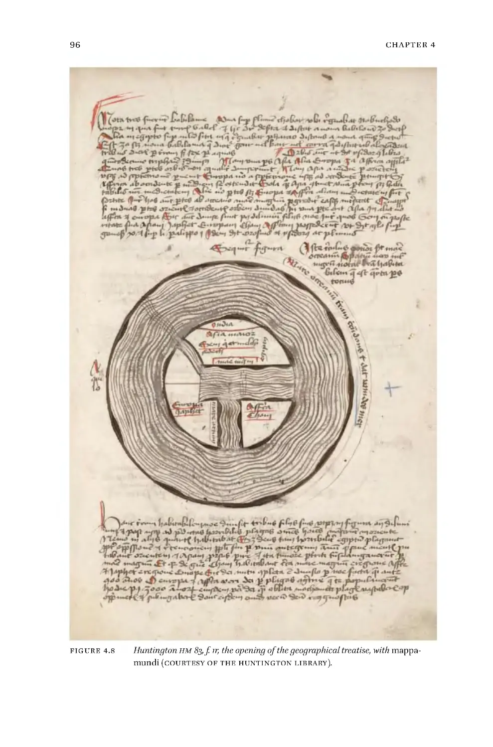
ff. 1r–8v, The Brief Geographical Treatise
•
f. 1r: The treatise opens with a discussion of the three Babylonias, and
then addresses the three-folddivision ofthe worldamongthe sons ofNoah,
illustrated witha mappamundithat emphasizes the circumfluent ocean and
theMediterranean.
•
f.1v:ListstheprovincesofGreaterAsia,includingScythia,MagnaGraecia,
andSyria,withmoredetaileddescriptionsofEgyptandEthiopia.
•
f. 2r: The description of Ethiopia continues, followed by Arabia,
Mesopotamia,Chaldea,Hyrcania,Armenia,Parthia,andIndia.Thenfollowsa
listoftheoceanicislandsthatpertaintoGreaterAsia,andalistoftheislands
oftheMediterranean.
•
f. 2v: A digression on Esther 1:1 which mentions 127 provinces between
IndiaandEthiopia,andthenalistoftheprovincesofEurope,beginningwith
theoceanicislandsthatpertaintoEurope.6
•
f.3r:Amaplabeledfigura insularum maris occeani,“mapoftheislandsof
theocean,”withalargecircumfluentoceanfilledwithcircularislandswhose
size is exaggerated for clarity—except in the south, where the cartographer
doesnotlocateanyislands.Belowthemapisalistoffiveoftheislandsinthe
MediterraneanthatpertaintoEurope,fromVenicetotheBalearics,withanote
toseethefollowingfigure.
•
f.3v:Twooverlappingmappaemundi,theupperoneemphasizingthefive
Europeanislandsjustlisted(plusportugalia,probablyan errorfor theportus
said on f. 3r to belong to one of the islands); and the lower one of the
MediterraneanislandsthatpertaintoGreaterAsia(seethelistonf.2r).
•
f.4r:AlistoftheprovincesofmainlandEurope,beginningwithadetailed
listoftheprovincesofGermany,thenItaly,andthenSpain.
•
f. 4v:The list of the provinces of Spain continues, followed by those of
France.ThenthereisalistoftheprovincesofmainlandAfrica.Thisistheend
ofthelistingoftheworld’sprovinces.
•
f.5r:Agenericview ofsomemountains,followedbyalistofthemoun-
tainsoftheHolyLand,andthenalistofmountainsindicatedasbeingonthe
edges of the Holy Land (Montes qui sunt termini terre promissionis sunt hii),
thoughthelistincludesmountainsasfarwestasthePillarsofHercules.
•
f.5v:Thelistofmountainscontinues,followedbyashortlistofthelands
of the kings of the Four Kingdoms of the Book of Daniel(Nebuchadnezzar,
6 ThematerialaboutoceanicislandsofEuropeonf.2vistranscribedbyAxelAnthonBjørnbo,
“Adam af BremensNordensop fattelse,” Aarbøger for Nordisk Oldkyndighed og Historie 24.2
(1909),pp.120–244,at240–241.
7
DescriptionofHuntingtonHM83
Cyrus,AlexandertheGreat,andOctavian),andalistofthelandsinwhichthe
twelve Apostles preached (there is a map that shows where the Apostles
preachedonf.15r,somedistancefromthistext).7
•
f.6r:ThelistofthelandsinwhichtheApostlespreachedcontinues,fol-
lowed by a map of the most important cities of the ancient world which is
basedonthediscussionoftheFourKingdomsontheprecedingfolio.
•
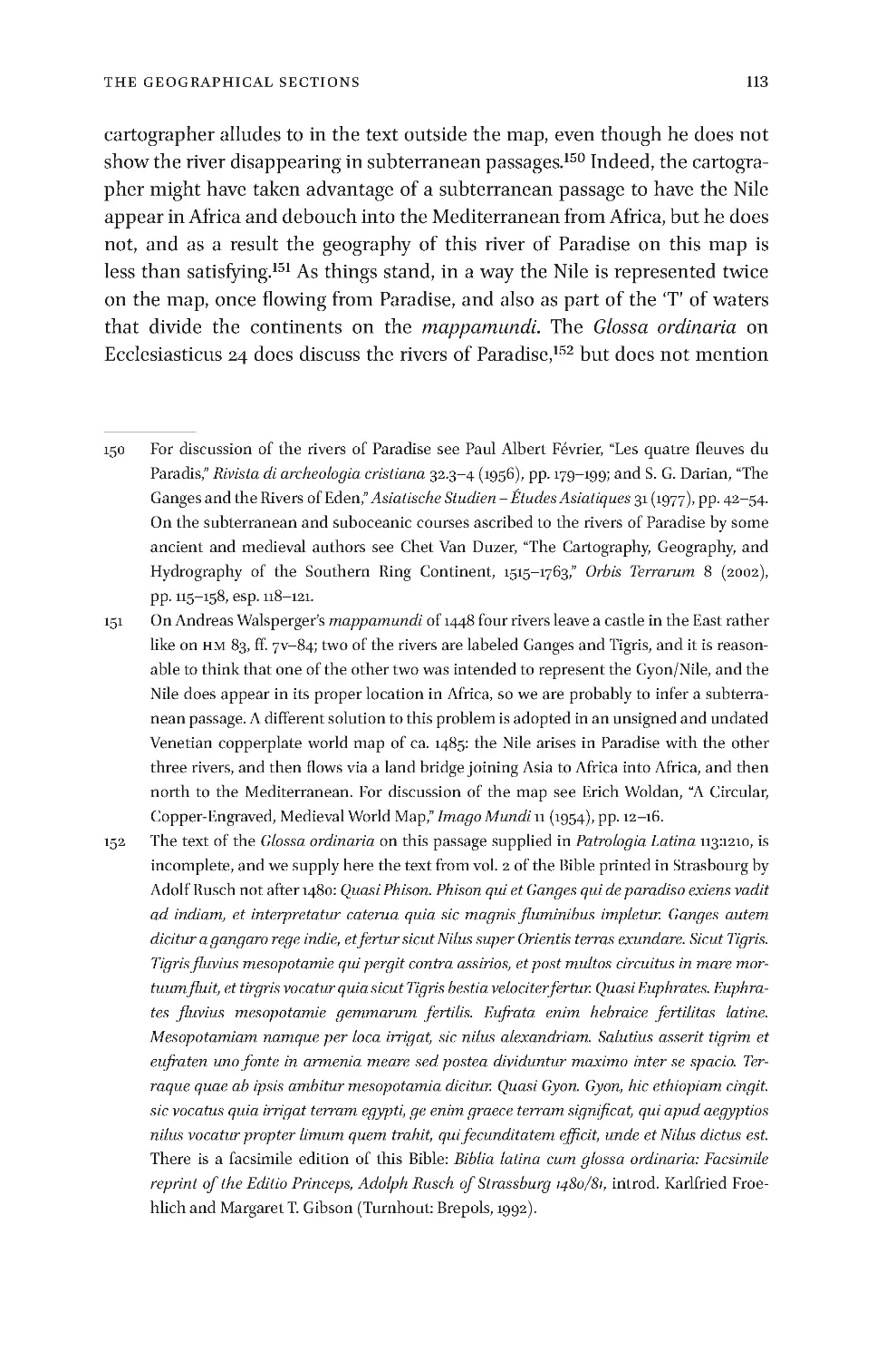
ff.6v–7r:Alarge maplabeledMappa mundi localis that combinesinfor-
mation from a few of the preceding sections, and thus shows many of the
islandsinthecircumfluentoceanlikethemaponf.3r,andalsoprovidesmore
detail about the mainland. The sphere of earth is shown off center in the
sphere ofwater(see Fig. 4.14 below),in accordance with one explanation of
howtherewaslandabovethewaters,despitethefactthatthesphereofearth
waswithinthesphereofwater.8
•
ff.7v–8r:AlargemaptitledMappa de Aquis terram irrigantibusormapof
thewatersthatirrigatetheland,whichplacesgreatemphasisonthefourrivers
flowingfromParadiseandthewatersthatmakeupthe‘T ’ofaT-Omap,9but
doesnotgiveinformationaboutotherrivers.
7 AlistoftheplacestheApostlespreachedalso occursinacontextassociatedwithbothcar-
tograp hy and the Apocalypse in manu scripts of Beatus of Liébana’s Commentary o n the
Apocalypse,wherethelistintroducestheworldmap.ThelistiseditedinBeatusofLiébana,
Obras completas de Beato de Liébana,ed.andtrans.JoaquínGonzálezEchegaray,Albertodel
Campo, and Leslie G. Freeman(Toledo:EstudioTeológicode SanIldefonso; andMadrid:
BibliotecadeAutoresCristianos,1995),pp.135and137.Butwedonotdetectanysignofinflu-
enceofBeatus’slistintheHuntingtonmanuscript.
8 ThisexplanationgoesbacktoPeterAbelard(1079–1142),Expositio in Hexameron,inPatrologia
Latina 178:748: se e W. G. L. Ran dles, “Classi cal Mod els of World Geogra phy an d their
TransformationFollowingtheDiscoveryofAmerica,”inWolfgangHaaseandMeyerReinhold,
eds.,The Classical Tradition and the Americas(BerlinandNewYork:W.deGruyter,1994-),vol.
1,European Images of America and the Classical Tradition,part1,pp.5–76,at22,andalsosee
thequotationonthissamesubjectfromPaulofBurgos(PablodeSantaMaría)inhisAdditiones
(writtenin1429)tothePostillaofNicholasofLyra,citedonRandles’sp.76.Randles’sessayis
reprintedinhisGeography, Cartography and Nautical Science in the Renaissance: The Impact
of the Great Discoveries(Aldershot, Hampshire, GreatBritain;andBurlington, VT :Ashgate/
Variorum, 20 00).Thereis a dramaticillustration ofthis explanationinLyon,Bibliothèque
Municipale,MS1351,f.35r,afourteenth-centurymanuscriptoftheBreviari d’amor.
9 AT-Omap,themosttypicalmedievalmappamundi,issocalledfromthe‘O’ofthecircumflu-
entoceanthatsurroundsthecircleofthelands,andthe‘T’formedbythebodiesofwaterthat
dividethelandintoAsia,Europe,andAfrica.UsuallytheMediterraneandividesEuropeand
Africa,theTanaisorDonRiverdividesEuropeandAsia,andtheNiledividesAsiaandAfrica.
As we willseebelow,the cartographerofthe mapinff.7v–8ridentifiesthebodies ofwater
thatseparatethecontinentsdifferently.
8
Chapter1
•
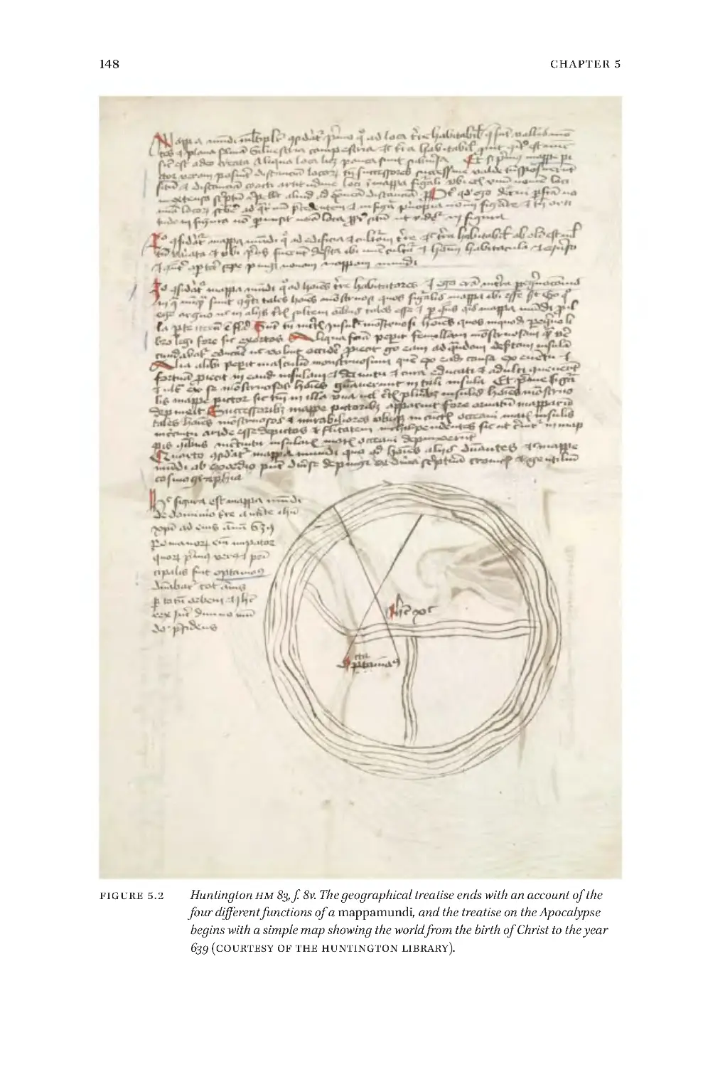
f.8v:Thegeographicaltreatiseendswithanaccountofthefourdifferent
functions or themes that a mappamundi can have; the treatise on the
Apocalypsebeginsonthelowerpartofthefolio.
2
ff. 8v–12v, The Treatise on the Apocalypse
•
f.8v:The treatiseon theApocalypsebegins witha simple mapshowing
the worldfrom thebirthofChrist to theyear639, whichis when the author
holds that Muhammad began his career (though this is not the traditional
date).
•
f.9r:Adetailedmapshowingtheworldfrom639to1514,particularlyillus-
tratingthespreadofIslam,whichissaidtobeinallpartsoftheworldexcept
Europe, andEuropeis saidtobeveryweak.In thetextsurroundingthemap
theauthorsaysthatitisbasedontheBookofRevelationfromchapter12tothe
beginningofchapter19.
•
f.9v:Aprophecymapshowingtheworldfrom1514to1570,whenSwordof
IslamhasconqueredEuropeandreachedallthewaytotheedgesoftheearth,
but nottotheislandsintheocean.Theauthorsaysthatthemapisbasedon
Revelation19:5–11.
•
f.10r:Asymbolicprophecymapshowingtheworldfrom1570to1600.The
series of small-to-large triangles in the center represent the increase of
Antichrist,andtheauthorsaysthattheotherspikesthatradiatetotheedgesof
theearthrepresentthetenhorns ofthebeastofDaniel7—thoughthere are
actuallyelevenspikesdepicted.Tenkings(Rex Egipti,Rex indie,etc.)areindi-
catedattheedgeofthemap.
•
f.10v:Aprophecymapoftheworldfrom1600to1606.Antichristisindi-
catedatthecenteroftheearth,inJerusalem,andthefourpeninsulasthatjut
intotheoceanaresymbolicgeographicalrepresentationsofthefourhornsof
Antichrist by which he will persuade people to join him (Deceit, Cunning,
Cruelty,andImitationoftheDeity).ThetentribesofIsraelareshowntravel-
lingfromtheirislandtoJerusalemtojoinAntichrist.
•
f.11r:Aprophecymapofthe worldfrom 1606to1661(thoughaswe will
see,thelatterdateisanerrorfor1651).Thesituationhaschangedcompletely:
thecenteroftheearthisnowoccupiedbytheflagandlawofChrist,whichwill
be raised and worshipped throughout the world. At the bottom of the folio
thereis a secondmapthat shows the surface of the earthdevoidof features
andplacenames,andthecircumfluentoceanemptyaswell.Thetextnearby
explainsthatallofthefeaturesoftheearthhavebeenburnedaway.
9
DescriptionofHuntingtonHM83
•
f.11v:AnillustrationoftheLastJudgment.ThegatesofParadiseareatthe
top,theelectin acurvedbandjustbelow,thenJesusandtheApostlesinthe
sky;belowon the earthis theMount ofOlives,thenthedamnedin a curved
bandstandingabovetheabyssthatleadstoHell.Thecenteroftheearthdoes
notcoincidewiththatofthewater,asisalsothecaseinthemapsinff.6v–7r
and7v–8r.
•
f.12r:DescriptionoftheLastJudgment,Resurrection,andrenewalofthe
earth.Atthebottomofthepagethereisamapofafeaturelessearthwhichthe
textsaysrepresentstheworldaftertheLastJudgment.
•
f.12v:AdiagramoftherelativediametersoftheearthandHell.Thetext
discusses theirdimensions, andthe crystallization ofthe earthfollowingthe
LastJudgment andits rolein separatingtheblessedandthedamned.At the
bottomofthepagethereisapassageaboutthethreeBabyloniasverysimilar
tothatonf.1r.
3
ff. 13r–18r, Heterogeneous Section on Astronomy and Geography
•
f.13r:Thecosmosisdepictedinadiagramofthesphereslabeledhec fig-
ura appellatur ffabrica mundi,fromthesphereoftheearthouttotheEmpyrean.
•
f.13v:Above,adiagramshowingthesphereoftheeartheccentricwiththe
sphereofwater,withanindicationofthecourseofthesunaroundtheearth
anddiscussionoftheirrelativesizes.Below,adiagramoftherelativesizesofa
star,theearth,andthemoon.
•
f.14r:Adiagramoftenclimaticzonesoverlaidonacopyofthemapofthe
watersoftheearthinff.7v–8r.Thetextlistsvariousplacesandtheclimatesin
whichtheyarelocated,andalsothedistancesbetweenafewplaces.
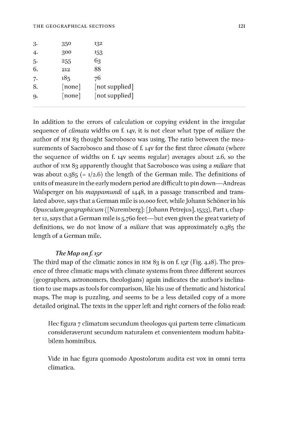
•
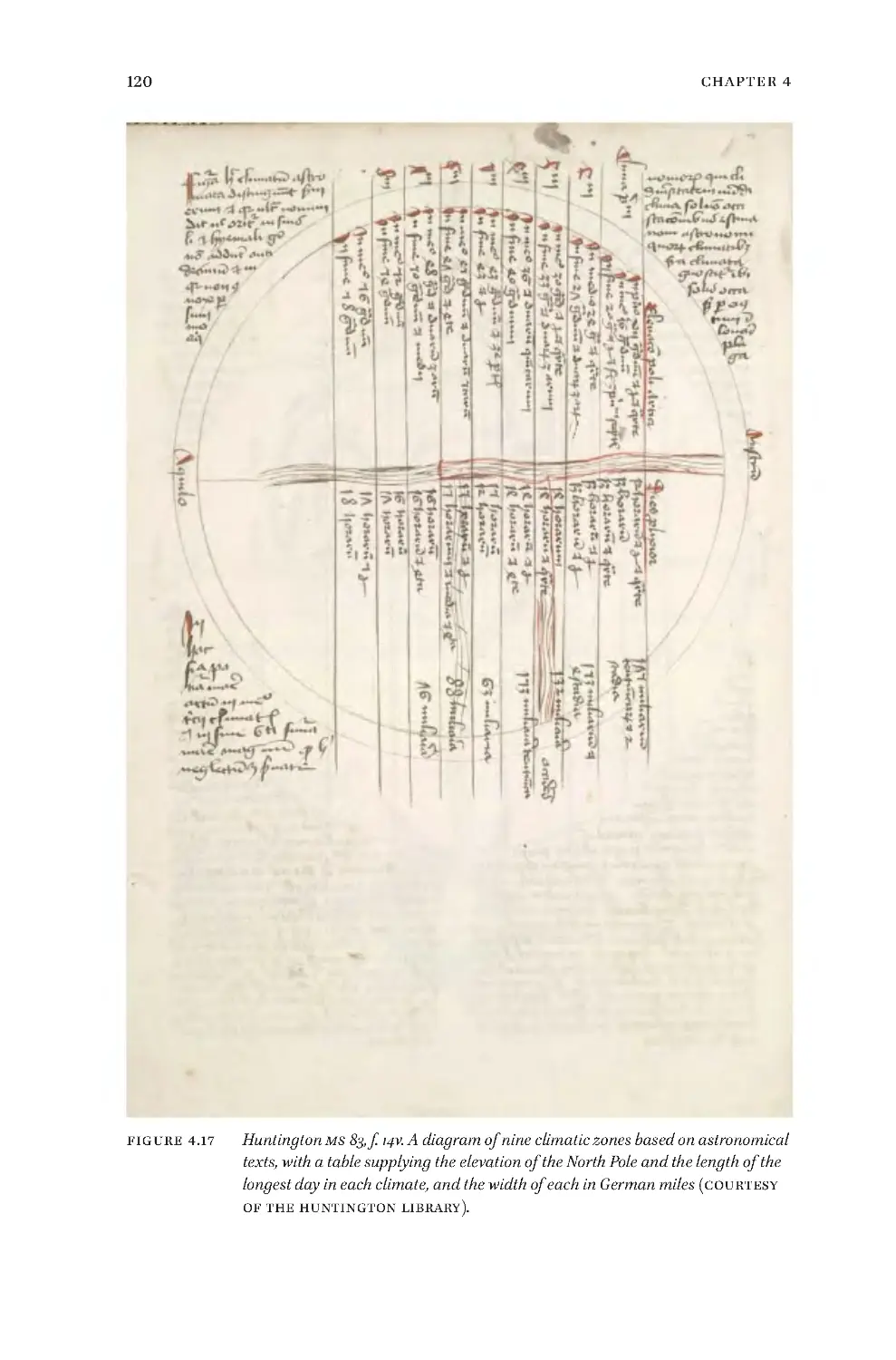
f.14v:Adiagramofnineclimaticzones,withatablesupplyingtheeleva-
tion of the North Pole, the length of the longest day, and the width of each
climateinGermanmiles.10
•
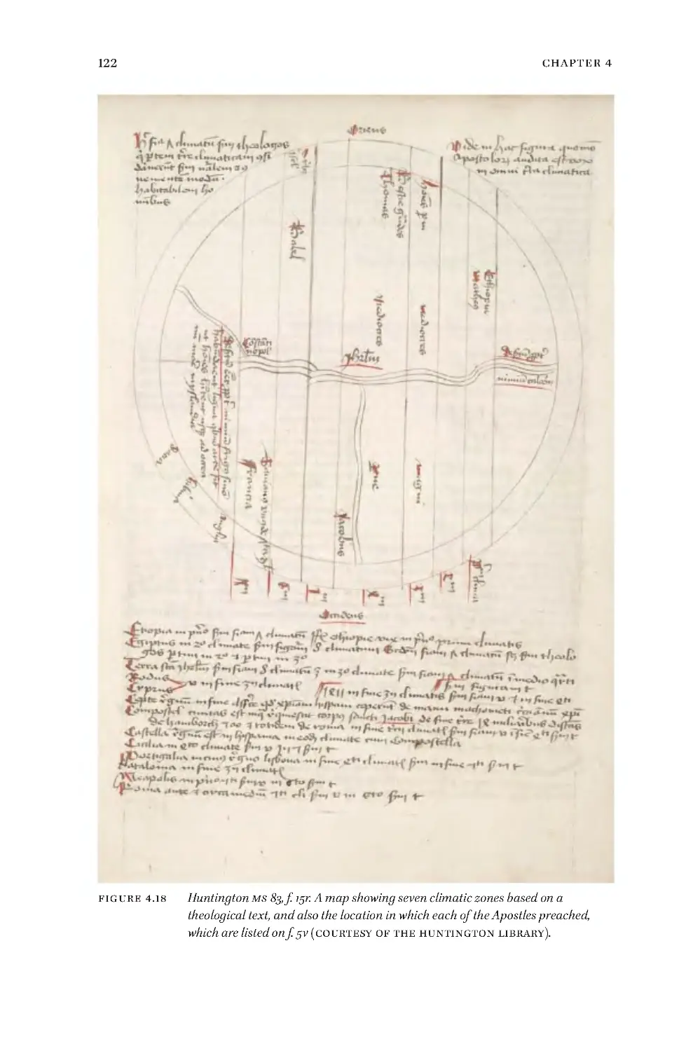
f.15r:Amapshowingsevenclimaticzonesandalsothelocationsinwhich
the Apostles preached (see the list of these places in f. 5v). Below the map,
10 Johannes deSacrobosco inhis De sphaera, book3, supplies the elevation,dies prolixior,
andmeasurementinmiliariaofeachclimate,butforaseven-climatesystem,andthushis
numbersareverydifferentthanthoseintheHuntingtonmanuscript.Itseemsthatsuch
a table originally accompanied Roger Bacon’s Opus maius: see Roger Bacon, The ʻOpus
majus’ of Roger Bacon,ed.JohnHenryBridges(London:WilliamsandNorgate,1900),vol.
1,p.296:Ostendam etiam cum latitudine cujuslibet climatis quot milliaria quodlibet contin-
eat in se, & quot gradus in coelo cuilibet respondeant, & quot horas habet dies prolixior.
10
Chapter1
undertheheadingOccidens,thereisalistofseveralregions,islands,andcities,
togetherwithindicationsofwhichclimatestheyarelocatedin.
•
f.15v:Thelistofplaceswiththeirclimatescontinues,withashortdiscus-
sionofGogandNoah’sArk.
•
f.16r:Asummaryofworldhistory,emphasizingtheLastDays.Historyhad
threeparts:thefirstendedwiththeFlood,thesecondcoincidedwithBabylon,
andthethirdwithRome.ThebirthofMuhammadcoincideswiththebegin-
ningofRome’sdecline,andtheglobalruleofIslamwillbeendedbytheLast
Roman Emperor and Jesus Christ. Then Antichrist will arise and come to
power, gaining followers through Deceit, Cunning, Cruelty, and Imitation of
theDeity(seef.10v).Hewillrulefor1000years—averyunusualdurationfor
his reign in the Apocalyptic tradition—with only Enoch and Elias, who will
returnfromParadise,preaching againsthim; theythen rise toHeaven again.
Antichristpromises todo the same andrises above theMount ofOlives,but
Jesuskillshimandbeginshisreign.
•
f.16v:Twogenealogicaltables,onefromAdamtoJesus(ignoringthelin-
eagethroughNathan),andonefromAdamtoDavid.
•
f.17r:Continuationofthesecondgenealogicaltable,splittingnowintwo,
andtracingontheleft,thelinefromDavidthroughNathantoHeli(andthen
wearetounderstandthatMary,whoislistedontheright,wasthedaughterof
Heli);andontheright,thelinefromDavidthroughSolomontoJacob,ending
withJesus.
•
ff.17v–18r:DiscussionoftheFourKingdomsoftheworld,11withdetailson
symbolsinthepropheticbooksoftheBible.
•
f.18v:blank.
4
ff. 19r–25v, Treatise on Astrological Medicine
•
f. 19r: The beginning of the texts on astrological medicine. The section
opens with two canonsfromBartholomäusMariensüss.12The firstisheaded
Canon primus de fleubotomia, “First precept on phlebotomy,” and begins
11 SeeH.H.Rowley,Darius the Mede and the Four Empires in the Book of Daniel: A Historical
Study of Contemporary Theories (Cardiff: University of Wales Press Board, 1935);Joseph
WardSwain, “TheTheoryoftheFourMonarchies:OppositionHistoryundertheRoman
Empire,”Classical Philology35.1(1940),pp. 1–21;andJanetL.R. Melnyk, “TheFourKing-
doms in Daniel 2 and 7: Chapters in the History of Interpretation,” Ph.D. Dissertation,
EmoryUniversity,2001.
12 OnthesecanonsseeDavidJuste,Les manuscrits astrologiques latins conservés à la Bayer-
ische Staatsbibliothek de Münich(Paris: CNRS éditions, 2011), p. 161; they were printed in
11
DescriptionofHuntingtonHM83
Notandum primo volens eligere dies aptos pro fleubotomia primo eligat signa
ignea que sunt aries et sagittarius....13 The second, which also begins on this
folio,isheadedCanon 2us de farmacia id est medicina,andbeginsYpocrates ait
Cecus medicus est qui astronomiam nescit nam si dabit medicinam.14
•
f.19v:Thetextonmedicinecontinuesfromthepreviousfolio.
•
ff. 20r–21r: The text begins Incipit messehallach de coniunctionibus, and
comesfrom Messahallah’sEpistola Messahalae de rebus eclipsium, et de coni-
unctionibus planetarum, translated by Joannes Hispalensis, which was later
printed in Liber quadripartiti Ptholemei (Venice: Octavianus Scotus, Bonetus
Locatellus,1493),andeditedbyJoachimHellerinMessahalae antiquissimi ac
laudatissimi inter Arabes astrologi, libri tres (Nuremberg: Apud Ioannem
Montanum&VlricumNeuberum,1549),Fiii-Giiiverso.15
JohannesRegiomontanus,Ephemerides(Venice:Ratdolt, 1481), on[a8v]-[a9v].Wethank
DavidJusteforthesereferences.
13 A text with essentially the same incipit(Volens eligere dies...)also appears in Augsburg,
Staats- und Stadtbibliothek, 2o Cod. 208, ff. 2r–10v: seeHandschriftenkataloge der Staat-
sund Stadtbibliothek Augsburg(Wiesbaden: O. Harrassowitz, 1974–1993), vol. 3, pp. 209–
216, at 211; Vienna, Österreichische Nationalbibliothek, MS 5184, ff. 8v–10r: see Grażyna
Rosińska, Scientific Writings and Astronomical Tables in Cracow: A Census of Manuscript
Sources (XI Vth-X VI th Centuries)(Wrocław:Ossolineum,PolishAcademyofSciencesPress,
1984),p.455,no.2373;andinMunich,BayerischeStaatsbibliothek,CLM24865,ff.25r–28v:
seeLynnThorndike and PearlKibre, A Catalogue of Incipits of Mediaeval Scientific Writ-
ings in Latin(London:MediaevalAcademyofAmerica,1963),col.1707F.Thismanuscript
islistedinCatalogus codicum manu scriptorum Bibliothecae regiae monacensis(Munich:
sumptibusBibliotecae,prostatinLibrariaPalmiana, 1858–2000),vol.4,part4,p. 150, no.
1533, as afifteenth-centurymanuscript,Calendarium cum excerptis ex Johanne de Monte
regali et aliunde ( f. 29 Tabula facta a. 1466 ad meridianum Patauii).
14 ThissametextoccursinLondon,BritishLibrary,HarleyMS2269,anastrologicalcompen-
diumfromthefirsthalfofthesixteenthcentury,onff.91r–91v.
15 OnMessahallahseeDavidPingree, “Māshā’allāh,”inCharlesCoulstonGillispie, ed.,Dic-
tionary of Scientific Biography(New York: Scribner, 1970-), vol. 9, pp. 159–162. Onthe De
rebus eclipsium see F.J. Carmody, Arabic Astronomical and Astrological Sciences in Latin
Translation: A Critical Bibliography(BerkeleyandLosAngeles,1956),pp.30–32;andLynn
Thorndike, “The LatinTranslation of AstrologicalWorksby Messahala,” Osiris 12(1956),
pp.49–72,at62–66,includingalistofmanuscriptsofthework.ThereisanEnglishtrans-
lation and discussion of the Hebrew version of the work in B. Goldstein, “The Book of
EclipsesofMasha’allah,”Physis6(1964),pp.205–213;andinAbrahamIbnEzra,The Book
of the World: A Parallel Hebrew-English Critical Edition of the Two Versions of the Text, ed.
andtrans.ShlomoSela(LeidenandBoston:Brill, 2010),pp. 240–259.ThereisanEnglish
translationoftheLatinversioninBenjaminN.Dykes,Astrology of the World(Minneapo-
lis:CazimiPress,2014),vol.2,pp.145–155.
12
Chapter1
•
ff.21r–21v:ThetextbeginsMiliaria ptholomei de magnitudinibus corporum
celestium et distantiis orbium sunt hec redacta ad theutonica miliaria secundum
quod 60 agri faciunt miliare,andendsutrum tam magne sint vel tam distent vide
in passionale de ascensione domini Raby moyses dicit ibi et cetera. Sed oportet
addiscentem credere. We have not succeeded in determining the source.
Ptolemy does supply the distances between the planetary spheres in his
Planetary Hypotheses, but this workwas unknownduringtheMiddle Ages.16
ThereferencetoRaby moysesistoMosesMaimonides(1135–1204),specifically
to a passage about the distances between the planetary orbs in Jacobus de
Voragine’sLegenda aureathatJacobusattributestoMaimonides.17Onf.21rof
HM83thecircumference oftheearthisgiven as9100 miliaria theutonica,but
onf.12vourauthorindicatesthatitis8000 miliarium teutonicorum,whichindi-
catesthatheisusingadifferentsourcethanintheearlierpassage(itisworth
mentioningthatthetwopassageswerewrittenbydifferentscribes).
•
f.21v:AbrieftextDe virtute et proprietate planetarum,“Onthevirtuesand
properties oftheplanets.”Wehavenotbeenable todetermine the source of
thetextonthefirsthalfofthefolio;thetextonthesecondhalf,whichbegins
Notandum quod 12 sunt signa, is excerpted and paraphrased from Robert
Grosseteste,De impressionibus aeris seu de prognosticatione.18
16 FortheGreektextofBook1ofthePlanetary HypotheseswithaGermantranslation,anda
German translation of Book 2(which does not exist in Greek, only in Arabic), seeJ. L.
Heiberg, ed.,Claudii Ptolemaei opera quae exstant omnia(Leipzig:Teubner, 1907), vol. 2,
Opera astronomica minora,pp.69–145.FordiscussionoftheworkseeNoelM.Swerdlow,
“Ptolemy’sTheoryoftheDistanceandSizesofthePlanets:AStudyoftheScientificFoun-
dationsofMedievalCosmology,”Ph.D.Dissertation,YaleUniversity,1968;andAlbertVan
Helden,Measuring the Universe: Cosmic Dimensions from Aristarchus to Halley(Chicago:
University of Chicago Press, 1985), pp. 21–25. The Arabic version of the text has been
translatedintoEnglishbyBernardR.Goldstein,“TheArabicVersionofPtolemy’s‘Plane-
taryHypotheses’,”Transactions of the American Philosophical Society54.4(1967),pp.3–55;
and into French by Regis Morelon, “La version arabe du Livre des Hypothèses de Ptolé-
mée,”Mélanges Institut Dominicain d’Études Orientales du Cairo21(1993),pp.7–85.
17 SeeGörgeK.Hasselhoff,“MaimonidesintheLatinMiddleAges:AnIntroductorySurvey,”
Jewish Studies Quarterly9.1(2002),pp.1–20,at11–13;JacobusdeVoragine,Legenda aurea,
ed.GiovanniPaoloMaggioni(Florence:SIS M E LandEdizionidelGalluzzo,1998),sect.67,
pp.483–484;andJacobusdeVoragine,The Golden Legend or Lives of the Saints,trans.Wil-
liamCaxton,ed.F.S.Ellis(NewYork:AMSPress,1973),vol.1,p.111.
18 ThetextofRobertGrosseteste,De impressionibus aeris seu de prognosticatione,issupplied
in Die Philosophischen Werke des Robert Grosseteste Bischofs von Lincoln,ed.LudwigBaur
(Münster:Aschendorff,1912),pp.41–51,withthepassageintheHuntingtonmanuscriptat
42–43.Fordiscussion oftheworkseeSamuelHarrisonThomson,The Writings of Robert
Grosseteste, Bishop of Lincoln, 1235–1253(Cambridge,England:TheUniversityPress,1940),
13
DescriptionofHuntingtonHM83
•
f. 22r: Text and two tables from Robert Grosseteste, De impressionibus
aeris seu de prognosticatione,19togetherwithacirculardiagramthatindicates
whichsignsofthezodiaccorrespondtowhichpartsofthebody—adiagram-
matic renderingoftheZodiacMan.20This materialdoesnot comefrom this
sameworkbyGrosseteste.
•
ff.22v–24v:TextbeginningDe divisione corporis humani secundum plane-
tas in natura eorumdem propria et cum egritudinibus sibi propriis, which
consistsofexcerptsfromWilliamofMarseille,De urina non visa(1219).21
•
f. 25r:Text under the heading De diebus criticis with a large square dia-
gramfordeterminingone’shoroscope;sourceundetermined.
•
f. 25v: Text ends: ...et tristicie nunc aspicit ascendens est quod locorum
gaudii saturni, Saturnus enim gaudet in lamentacione planctu et tribulatione.
ThistextseemstobeaparaphraseofapassageintheDe astronomia tractatus
x of Guido Bonatti, the celebrated thirteenth-century astronomer and
astrologer.22
pp. 103–104, which includes a list of manuscripts; to that list should be added Harvard
University, Houghton Library, MS Lat 361, ff. 104r–105r, thirteenth century. Also see Ezio
Franceschini, “Sulla presunta datazione del ‘De impressionibus aeris’ di Roberto Gros-
satesta,”Rivista di filosofia neo-scolastica44(1952),pp.22–23.
19 This text from Grosseteste‘s De impressionibus aeris is supplied in Die Philosophischen
Werke des Robert Grosseteste Bischofs von Lincoln(seeCh.1,n.18),pp.43–44 .
20 SeeCharlesWestClark,“TheZodiacManinMedievalMedicalAstrology,”Ph.D.Disserta-
tion,UniversityofColoradoatBoulder,1979;andthe sameauthor ’s “TheZodiacManin
Medieval Medical Astrology,” Journal of the Rocky Mountain Medieval and Renaissance
Association3(1982),pp.13–38.
21 See William of Marseille, Guillaume l’Anglais, le frondeur de l’uroscopie médiévale (X I II e
siècle): édition commentée et traduction du ‘De urina non visa’, ed. and trans. Laurence
Moulinier-Brogi(Geneva:LibrairieDroz,2011),pp.144–148and254.Thetextofthischap -
teris alsosuppliedinGrazielaFredericiVescovini, “Iprogrammidegliinsegnamentidel
collegio di medicina, filosofia e astrologia, dello statuto dell’Università di Bologna del
1405,” in Jacqueline Hamesse, ed., Roma, magistra mundi: itineraria culturae medievalis:
mélanges offerts au Père L.E . Boyle à l’occasion de son 75e anniversaire(Louvain-la-Neuve:
Fédération des Institutsd’EtudesMédiévales, 1998), vol.3,pp. 193–223, esp. 213–214. For
discussions of the work beside the very thorough one offered by Moulinie-Brogi in his
introductionseeLynnThorndike,A History of Magic and Experimental Science(NewYork:
Macmillan, 1923–58), vol. 2, pp. 485–487; and Roger French, “Astrology in Medical
Practice,”inLuisGarcíaBallester etal., eds.,Practical Medicine from Salerno to the Black
Death (Cambridge and New York: Cambridge University Press, 1994), pp. 30–59, esp.
44–48.
22 SeeGuidonis Bonati foroliviensis mathematici De astronomia tractatus x. universam quod
ad iudiciariam rationem Nativitatum, Aëris, Tempestatum, attinet, comprehendentes(Basel,
1550), Parsprima, cols.92–93, “InquibusdomibusPlanetaegaudentCap. XI”;translated
14
Chapter1
Someaspectsofthearrangementofmaterialinthemanuscriptaredifficultto
understand. The manuscript has three well-defined parts: the geographical
materialonff. 1r–8v, whichends withadiscussion ofthefourdifferentfunc-
tions of mappaemundi; the treatise on theApocalypse onff. 8v–12v; and the
materialonastrologicalmedicineonff.19r–25v.Thegeographicalmaterialon
ff.1r–8vmaybetakenasasortofprefacetotheapocalypticsection,describing
theworld’sgeographybeforeitunderwentdramaticchangesintheLastDays,
andreviewingtheFourKingdomsoftheworld(f.5v)andalsothemissionsof
theApostles(ff.5v–6r).The role oftheheterogeneous section on astronomy
and geography onff. 13r–18r is less clear. On the one hand, the astronomical
material makes the section a good transition to the material on astrological
medicine, but on the other, there are strong connections between the geo-
graphicalmaterialinthissectionandthatinff.1r–8v:forexample,themapof
thePtolemaicclimaticzonesonf.14r(seeFig.4.16)isclearlybasedonthemap
oftheworld’swatersonff.7v–8r(seeFig.4.15below),andthemapoftheloca-
tionswheretheApostlespreachedonf.15riscloselyrelatedtothelistofthe
places that the Apostles preached onff. 5v–6r.For convenience,in what fol-
lows,thegeographicalmaterialinthesetwosectionswillbetreatedtogether.
into English in Benjamin N. Dykes, The Book of Astronomy (Golden Valley, M N: Cazimi
Press, 2007), vol. 1,pp.140–141.OnBonattiseeCesareVasoli,“L’astrologoforliveseGuido
Bonatti,”Atti del convegno internazionale di studi danteschi (Ravenna, 10–12 settembre 1971)
(Ravenna: Longo, 1979), pp. 239–260; and Bernhard Dietrich Haage, “Bonatti, Guido,” in
Wolfgang Stammler and Karl Langosch, eds., Die deutsche Literatur des Mittelalters:
Verfasserlexikon(BerlinandNewYork:deGruyter,1978-),vol.11,cols.269–270.
15
TheHistoricalContext:LübeckintheFifteenthCentury
Chapter2
The Historical Context: Lübeck in the Fifteenth
Century
The city of Lübeck was founded on an island in the river Trave by Adolf II,
CountofSchauenburgandHolstein,in1143.ItspositionontheTrave,witheasy
accesstotheBaltic,gaveitgreatpotentialasacenteroftrade,andthatpoten-
tialwasrealizedthroughitsleadershipoftheHanseaticLeaguebeginningin
thefourteenthcentury,anditsroleasanodeintheBaltictradenetworkthat
stretchedfromNovgorodintheeasttoLondonandFlandersinthewest,and
includedNorwayandSwedentothenorth.Timber,fur,honey,andgrainflowed
fromeasttowest,whileclothandmanufacturedgoodsflowedeast,andcopper
ore,ironore,andfishcamesouth.1
Lübeckwasatthepeakofitspowerduringthefifteenthcentury,inthelat-
terpartofwhich(1486–88)thetextsinHuntingtonHM83werecomposed.The
city’spoliticianswerewidelyrespectedandhelpedresolveanumberofinter-
nationaldisputes,andthecity’sdynamicmayor,HinrichCastrop(1419–1488),
strengthenedthecity’swalls,improveditsharbor,andin1478organizedwhat
wasperhapsthemostspectacularpageantthecityhadeverseentohonorthe
arrivalofAlbert,DukeofSaxony.2
1 OnthetopographyandgrowthofthecityseeManfredGläser,“TheEmergenceofLübeckas
aMedievalMetropolis,”inNilsEngbergetal.,eds.,Archaeology of Medieval Towns in the Baltic
and North Sea Area(Copenhagen:TheNationalMuseum,DanishMiddleAges&Renaissance;
andOdense:UniversityPressofSouthernDenmark,2009),pp.79–92.Thereisagooddiscus-
sion of the nature of the Hanseatic Leagu e and Lübeck’s role as its head in StuartJenks,
“A Capital withou t a State:Lübeckcaput tocius hanze(to 1474),” Historical Research65.1 57
(1992),pp.134–149;forbriefdiscussionofLübeckinthecontextofnorthernEuropeantrade
seeMichael Postan, “TheTrade ofMedieval Europe:TheNorth,”in EdwardMiller, Cynthia
Postan,andMichaelM.Postan,eds.,The Cambridge Economic History of Europe,vol.2,Trade
and Industry in the Middle Ages(Cambridge:CambridgeUniversityPress,1987),pp.168–305
passimandesp.237–239and277–279.ThereisanextensiveaccountofLübeckintheMiddle
AgesinErichHoffmann, “LübeckinHoch- undSpätmittelalter: Die großeZeitLübecks,”in
AntjekathrinGrassmann, ed.,Lübeckische Geschichte(3rd edn.Lübeck: Schmidt-Römhild,
1997),pp.79–340.
2 WilsonKing,Chronicles of Three Free Cities, Hamburg, Bremen, Lübeck(London:J.M.Dent&
Sons;andNewYork:E.P.Dutton&Co.,1914),pp.380–383;alsoseeGerhardNeumann,Hinrich
Castorp: Ei n Lübecke r Bürgermei ste r aus de r zweiten Hälfte des 15. Jahrhunderts (Lübeck:
Staatsarchiv,1932)(=VeröffentlichungenzurGeschichtederFreienundHansestadtLübeck,
© koninklijkebrillnv,leiden,2016 | doi10.1163/9789004307278_004
16
Chapter2
Aletterwritteninabout1453oralittlelaterbyadoctortoapatrononthe
city council was preserved by the Councilman Simon Batz, who was active
from1457–1464,andoffersaglowingdescriptionofthecity,anditisworthcit-
ingthedescriptioninfull:3
Sethercleunumscio,uthiclocusegregiusadivinaterrenaqueimperiali
maiestate plerisque dodatus est muneribus. Hic sunt fluenta limpidis-
sima, aer serenissimus, terra opima, nemora iocundissima, pomeria
florentissima,edificiapulcherrima,plateefecibussemperpurgate,presul
devotissimus, clerus disciplinatus, beneficia grassa, templa politissima,
in quibus divine laudes perpetim summo cultu peraguntur, turres
altissime que suis aureis fulgoribus intuencium oculis eminus chorus-
cant, cenobia preclara omni religione fulgencia, bibliotece numero
librorum ditissime, divini verbi precones disertissimi, mercatores in
negociacionibus studiosissimi, cives omnium rerum opulentissimi: Et
quodsuperest,policiareipubliceornatissima,civitasomnibusdefension-
ibus munitissima, totaque gens apprime pacifica. Sed taceo de pulchro
femineosexu,cuiusdelectabilisintuituslassataingeniavirescogitrecu-
perare. Venus enim ac Dyana nostras Lubicenses in pulchritudine
antecedunt; illas enim vero morum venustas, personarum proceritas,
melliflua eloquia, roseus lilialisque aspectus opulentissime decorant.
Sagaxquippenaturainearundemnobilicreacionepenitusinnulloerra-
vit. Porro ut summarie proferam: quidquid boni ac pulchri est hic
11); FritzRörig, “HinrichCastrop,Bürgermeister vonLübeck,” inPeterRichardRohden, ed.,
Gestalter de utsche r Vergangenheit(Potsdam and Berlin:Sanssou ci, 1937), pp. 215–216;and
AntjekathrinGrassmann,“Castorp,Hinrich:geb.1419Dortmund(?),gest.14.4. 1488Lübeck.
– Kaufmann, Bürgermeister, Diplomat,”Biographische s Lexikon für Schleswig-Holstei n und
Lübeck(Neumünster:Wachholtz, 1970–2011), vol. 13,pp.96–99.For moredetailontrade in
LübeckintheearlyfifteenthcenturyseeMichailLesnikov,“LübeckalsHandelsplatzfürost-
europäischeWarenim15.Jahrhundert,”Hansische Geschichtsblätter78(1960),pp.67–86;and
HarmvonSeggern,“DieführendenKaufleuteinLübeckgegenEndedes15.Jahrhunderts,”in
Gerhard Fouquet, ed., Netzwerke im europäischen Handel des Mittelalters(Ostfildern:
Thorbecke,2010),pp.283–316.
3 TheLatintext quoted hereis supplied byV.Wattenbach, “AusdemBriefbuchedesMeister
Simon von Homburg,”Anzeiger für Kunde der deutschen Vorzeit, Neuefolge, 20.2(February,
1873),cols.33–36,at35–36;andCarlFriedrichWehrmann,“EinUrtheilüberLübeckausder
MittedesfünfzehntenJahrhunderts,”Zeitschrift des Vereins für Lübeckische Geschichte und
Altertumskunde4(1884),pp.271–274,at273;aGermantranslationissuppliedbyAntjekathrin
Grassmann,“Lübeck–‘EinZweitesParadies’?:EinBlickaufdieReichs-undHansestadtinder
zweitenHälftedes15.Jahrhunderts,”inBernt Notke. Das Triumphkreuz im Dom zu Lübeck(Kiel:
Ludwig,2010),pp.35–48,at35–36.TheEnglishtranslationhereisours.
17
TheHistoricalContext:LübeckintheFifteenthCentury
splendidius copiosiusque quam in ceteris invenitur locis. Alter quoque
paradisusnoninmeritopoteritappellari.
TheonethingIknow,byHercules,isthatthisexcellentplaceisprovided
by the divine and the earthly imperial majesty with many gifts. Here
there are the clearest streams, the brightest air, the best soil, graceful
groves,flourishingparks,beautifulbuildings,streetsalwaysfreeoffilth,a
godlybishop,well-orderedclergyandrichbenefices,beautifulchurches
wherethepraiseofGodisalwayssunginthemostsplendidmanner,high
towers,whosegoldenlustershinesintheeyesofbeholdersfromafar,and
famous monasteries shining with religion, libraries very rich in books,
and eloquent preachers of the divine word, merchants very zealous in
their businesses, and citizens wealthy in all things. What is more, the
stategovernmentishighlyhonored,thecityiswellprotectedbyramparts
ofallkinds,andthepopulationisverypeaceful.ButIsaynothingofthe
beautifulwomen,whosedelectableappearancecausesone’stiredspirits
torecoverenergy.VenusandDianamayexceedthewomenofLübeckin
beauty, but the city’s women are abundantly endowed with charming
manners,height, mellifluous eloquence,andtheaspectofrosesandlil-
ies. Indeed, wise Nature made not the slightest error in their noble
creation.Tosumup:whateverisgoodandbeautifulispresentheremore
splendidlyandcopiouslythaninothercities,sothatLübeckcanrightly
becalledasecondparadise.
Ofcoursetextspraisingcities,laudes urbium,wereawell-establishedliterary
genre,4butinthecaseofLübeckinthesecondhalfofthefifteenthcentury,the
cityseemstohavemeritedthispraise:soconcludesAntjekathrinGrassmann
at the end of her article just cited. There is a somewhat less encomiastic,
but still enthusiastic description of the city in Hartmann Schedel’s Liber
4 SeeJ.K.Hyde,“MedievalDescriptionsofCities,”Bulletin of the John Rylands Library48(1965–
1966),pp.308–340;reprintedinJ.K.Hyde,Literacy and its Uses: Studies on Late Medieval Italy,
ed. DanielWaley(Manchester andNewYork:ManchesterUniversityPress, 1993),pp. 1–32;
CarlJoachimClassen,Die Stadt im Spiegel der Descriptiones und Laudes urbium in der antiken
und mittelalterlichen Literatur bis zum Ende des zwölften Jahrhunderts(HildesheimandNew
York:Olms,1980);andHartmutKugler,Die Vorstellung der Stadt in der Literatur des deutschen
Mittelalters(Munich:Artemis,1986).
18
Chapter2
chronicarumof1493,5andJohannesSchönerin1515describesthecityasnego-
ciatoro locus celeberrimus,“aplaceverywellknowntothebusinessman.”6
ItisinterestingthattheauthorofHM83wouldwriteabouttheApocalypse
in a city that at the time was a “second paradise.” While plagues and other
eventssuchasthefallofConstantinopletotheTurkscouldinclineauthorsto
thoughtsoftheendoftime,7authorsarenotmerelytheproductsoftheirsur-
roundings:forexample,althoughhelivedinatimeof“plague,famine,extreme
weather,earthquakes,aviolentcivilwar,andbarbarianinvasions,”Andrewof
Caesarea(563–637)inhisCommentary on the Apocalypse concludedthat the
end of the world was not approaching.8 It is also worth keeping in mind
BernardMcGinn’s observation that “Apocalypticismhas alwaysbeen charac-
5 HartmannSchedel,Liber chronicarum(Nuremberg:Anton Koberger, 1493),ff. 270v–271r(in
theGermaneditionthepassageisonff. 265v–266r);HartmannSchedel,Sarmatia, the Early
Polish Kingdom: From the Original Nuremberg Chronicle, Printed by Anton Koberger in 1493,
trans.BogdanDeresiewicz(LosAngeles:PlantinPress,1976),pp.37–40.Onthedescriptions
and im ages of cities in the Liber chroni carum see Albrecht Classen, “Hans Sachs and his
Encomia Songs on German Cities: Zoom ing Into and Out of Urban Space from a Poetic
Perspective. With a Consideration of Hartm ann Schedel’s Liber Chroni carum (1493),” in
AlbrechtClassen,ed.,Urban Space in the Middle Ages and Early Modern Age(BerlinandNew
York:WalterdeGruyter,2009),pp.567–594.ForHansSachs’sencomiumofLübeck,whichwas
writteninthesecondhalfofthesixteenthcentury,seeHansSachs,Hans Sachs,ed.Adelbert
vonKellerandEdmundGoetze(Hildesheim:G.Olms,1964),vol.23,pp.450–452.Volume23
inthis reprintingis vol. 207 of the Bibliothekdes LiterarischenVereins in Stuttgart in the
earlieredition(Tübingen:Literar.Verein,1870–1908).
6 SeeSchöner’sLuculentissima quaedam terrae totius descriptio(Nuremberg:IoannisStuchssen,
1515),f.31v.Thereisamid-sixteenth-centuryaccountofthecityinMünster’sCosmographia:
see Sebastian Münster, Cosmographiae unive rsalis Lib. 6 (Basel: Petri, 1552), Book 3, pp.
733–737.
7 SeeforexampleLauraAckermanSmoller,“OfEarthquakes,Hail,Frogs,andGeography:Plague
andtheInvestigationoftheApocalypseintheLaterMiddleAges,”inCarolineWalkerBynum
and Paul Freedman, eds., Last Things: Eschatology and Apocalypse in the Middle Ages
(Philadelphia: UniversityofPennsylvaniaPress, 200 0), pp. 156–187and316–337; Robert E.
Lerner, “The Black Death and Western Europ ean Eschatological Mentalities,” American
Historical Review 86.3(1981),pp.533–552;Wolfram Brandes, “DerFall Konstantinop els als
ap okalyptischesEreignis,” in SebastianKolditz and Ralf C. Müller, eds., Geschehene s und
Geschriebenes: Studien zu Ehren von Günther S. Henrich und Klaus-Peter Matschke(Leipzig:
Eudora-Verlag, 2005),pp.453–470;andKayaŞahin, “ConstantinopleandtheEndTime:The
OttomanConquestasaPortentoftheLastHour,”Journal of Early Modern History14.4(2010),
pp.317–354.
8 AndrewofCaesarea,Commentary on the Apocalypse,trans.EugeniaScarvelisConstantinou
(Washington,DC :CatholicUniversityofAmericaPress,2011),esp.pp.12–15.
19
TheHistoricalContext:LübeckintheFifteenthCentury
terized by an intricate mixture of optimism and pessimism.”9The choice of
subjectbytheauthorofHM83mayreflectapiousthinkeruninfluencedbyhis
prosperoussurroundings;itmayalsoindicateamanwithadifferentlifeexpe-
rience than most other citizens ofLübeck, apossibilitythat willbeexplored
below.
LübeckdidnothaveauniversityintheMiddleAges,butprintingwasestab-
lishedreasonablyearlyinthecity,in1474,fouryearsafterthetechnologyhad
reachedNuremberg,andtwoyearsbeforeitreachedRostockandLondon,for
example. One of the first books published in the city was the anonymous
Rudimentum novitiorum,printedbyLucasBrandis,whichcontainsmaps,and
whichwewilldiscussinmoredetailbelow.10Theencomium ofLübeckcited
abovementionsthe“richlibraries”ofthecity’smonasteries,andwedoknow
thattherewereatleasttwoextensiveprivatelibrariesinthecity.Onebelonged
to Simon Batz, the councilman and humanist who preserved the letter con-
tainingtheencomium;11andtheotherbelongedtothevicarConradStenhop:
intheUniversitätsbibliothekRostocktherearetwenty-ninefolioincunabula,
all of them on juridical subjects, which Stenhop illuminated himself. Given
that his library must have included theological works as well, Stenhop had
an unusually large collection for the time.12 Additional information about
9 Bernard McGinn, “The Apocalyptic Imagination in the Middle Ages,” in Jan A. Aertsen
andMartinPickavé,eds.,Ende und Vollendung: Eschatologische Perspektiven im Mittelalter
(Berlin:W.deGruyter,2002)(=MiscellaneaMediaevalia29),pp.79–94,at84.
10 On early printing in Lübeck see IsaakCollijn, “Lübecker Frühdrucke in der Stadtbiblio-
thekzuLübeck,”Zeitschrift des Vereins für Lübeckische Geschichte und Altertumskunde 9
(1908), pp. 285–333; and Dieter Lohmeier, “Die Frühzeit des Buchdrucks in Lübeck,” in
AlkenBrunsandDieterLohmeier, eds.,Die Lübecker Buchdrucker im 15. und 16. Jahrhun-
dert. Buchdruck für den Ostseeraum(Heide inHolstein:Boyens, 1994),pp. 11–53 .Fordis-
cussionoftheadventoftheRenaissanceinLübeckseeTheodoreHach,Die Anfänge der
Renaissance in Lübeck(Lübeck:H.G.Rahtgens,1889).
11 SeeRobert Schweitzer andUlrichSimon, “‘Boeke, gude undeböse...’:DieBibliothekdes
Lübecker Syndikus Simon Batz von Homburg; Rekonstruktionsversuch anhand seines
Testaments und der Nachweis aus dem Bestand der ehemaligen Ratsbibliothek in der
StadtbibliothekLübeck,”inRolfHammel-KiesowandMichaelHundt,eds.,Das Gedächt-
nis der Hansestadt Lübeck: Festschrift für Antjekathrin Grassmann zum 65. Geburtstag
(Lübeck:Schmidt-Römhild2005),pp.127–158;fordetailsonBatzseeGerhardNeumann,
“ Simon Batz, Lübecker Syndikus und Humanist,” Zeitschrift des Vereins für Lübeckische
Geschichte und Altertumskunde58(1978),pp.49–73.
12 G. Kohfeldt, “Der LübeckerVikar Conrad Stenhop, ein mittelalterlicherIlluminator und
Büchersammler,” Centralblatt für Bibliothekswesen 20 (1903), pp. 281–285; English sum-
maryinThe Literary Collector: A Monthly Magazine of Booklore and Bibliography6(1903),
20
Chapter2
librariesinLübeckinthefifteenthcenturywouldcertainlybewelcome,butit
does seem that the author of HM83wouldhavehadaccess to amplebiblio-
graphicresourcesforresearchingandcomposinghisbook.
p.97.AlsoseeNilüferKrüger,Conradus Stenhop: Geistlicher – Gelehrter – Sammler; Inku-
nabeln der Universitätsbibliothek Rostock(Rostock:Universität,1998).
21
TheAuthor
Chapter3
The Author
TheauthoroftheworksinHM83doesnotindicatehisname,buthedoesgive
somecluesabouthisidentity.Asindicatedabove,theworksinthemanuscript
seem to have been composed in Lübeck, so we can confine our attention to
candidatesfromthatcity.1OfcoursethefactthatHM83includesasubstantial
and apparently original section on the Apocalypse suggests that the author
wasamanofthecloth,andthislikelihoodseemsconfirmedbyhisindication
of his purposein writing his book(on f. 12v): Arbitror ergo quod harum figu-
rarum firma fides et frequens consideratio efficacius hominem retraherent a
peccatis quam multa bona verba, “I believe therefore that a firm faith in and
frequentcontemplationofthesediagramswillmoreeffectivelyrestrainaman
fromsinsthanwouldmanygoodwords.”Thatis,thestatedaimoftheworkis
religious edification, while its implicit purpose is preparation for the Last
Judgment.
Onthe samefolio(f.12v),whichcontainsadiagramoftherelativediame-
tersofearthandofHell,theauthorwrites,Hanc figuram calculavi secundum
regulas geometrie ex supposita quantitate ambitus terre 8000 miliarium teutoni-
corum...,“Icalculatedthisdiagramaccordingtotherulesofgeometryfromthe
supposed circumference of the earth, 8000 German miles...,” and this state-
mentimpliesthathehadatleastsometraininginmathematics.
The author’s most interestingand revealing statements about himself are
onf.8v,inhisdiscussion ofthedifferentpurposes ofmappaemundi.Thefol-
lowingpassagerevealsthattheauthorhadexperiencemakingmapsandhad
thoughtabout theproblemsinvolved,particularlythelackofspacefor allof
the place names; had traveledto the Holy Land; had read at least one travel
book; and had studied other mappaemundi, including their sources. As the
Latinissuppliedbelow,wequoteonlyourEnglishtranslationhere:
1 InoursearchfortheauthoroftheworksinHM83weconsultedRhimanA.Rotz,“Profilesof
SelectedLubeckCitizens,1360–1450,forInvestigationsintoPoliticalandSocialHistory,”type-
written m anuscript, on dep osit in the Archiv der Hansestadt Lübeck, 1975, Bestand 9.1,
SignaturLXIII12_1 .Rotz’sworkwouldofferagreaterchanceofincludingtheauthorofthe
worksinHM83ifitextendedlaterintothefifteenthcentury,butitdoesincludeinformation
abou t the travels of the people listed.Wedidnotfind anygoodcandidates am ongthese
profiles.
© koninklijkebrillnv,leiden,2016 | doi10.1163/9789004307278_005
22
Chapter3
Andevenifthefirstpainterofamapputthetruedistanceofplaces,yet
<his> successors, one after another, significantly transposed the places
anddistances,forcedbythenarrownessofspaceintheillustratedmap,
where even one place name written in full would force another to an
incorrectlocation.BecauseofthisIdecidedtowritethewholenamesof
places eachopposite to thepreceding <one?>, andin the mapto write
justthebeginningsofthenames,sothatthenarrownessinthemapwill
not restrict the names and places because of their position, as may be
seeninthemap....Ihavebeeninthelandofpilgrimageinwhichthere
arenosuchgatheringsofmonstrousmenasaredepictedthereinmaps.
Because ofthis,Iargue that suchmen are onlyinallotherparts ofthe
world,andthat consequently,thecommon mappamundiisinthatpart
once again mistaken. However, in certain islands there are monstrous
men whom I read in a travel book are born as follows. A woman gave
birthtoa monstrousfemalechildwhom she wasashamedto raise, and
shewishedtokillher,soshecastherawayonacertaindesertedisland.In
another place, another womangavebirthto a male monster, whomfor
the same reason, by an accident offortune, she cast awayon the same
island.ThroughGod’swillandcare,theywerebroughtup,andwhenthey
were adults, they came together and thereupon they generated mon-
strousmeninthatisland.Andthepainterofthefirstillustratedmapthus
paintedmonstrousmeninthatoneisland,orratherinmanyislands.To
latermappainters,suchmonstrousmenandotherthingsstillmoremar-
velouspaintedeverywhereinalloftheislandsintheocean<and>inthe
edge of the mainland appeared to be a <mere> decoration of maps.
Thinkingnothingofthefalsehood,theypaintedthemincommonmaps
in the circuit of islands in the ocean.... From the beginning, mappae-
mundiwerediverselypaintedfromHolyScripture,chronicles,andpagan
cosmography.
Thisfascinatingpassageraisesmanyinterestingquestions,forexample:What
werethemappaemundithatshowedmonstrousracesintheHolyLand?And
whatisthetravelbookthatgivesthisaccountofthegenerationofmonsterson
islands? These and other questions that the passage raises will be discussed
below,butsufficeittosayherethatthepassageestablishestheauthorasaman
with abundant experience studying mappaemundi. It is worth pointing out
thattheauthorsaysthathe“wasinthelandofpilgrimage”(eram in terra per-
egrinationis),butnotthathewasapilgrim—thoughhedoesnotexplicitlysay
thathewasnotapilgrim,either.
23
TheAuthor
Withregardtotheauthor’sjourneytotheHolyLand,Lübeckwasacommon
stoppingpointofnorthernEuropeanpilgrimsgoingtoSantiagodeCompostela
inSpain,andinfact ahostelforpilgrims,namedforSt.GertrudeofNivelles,
patron saint of travelers, was built in the city in 1360.2There was no similar
buildinginLübeckforpilgrimstotheHolyLand,andtheexpenseanddifficul-
ties ofthat voyage to the east entailedthat the number ofpilgrims traveling
therefromGermanywasnothigh.3Butwedohaverecordsofseveralresidents
ofLübeckwhomadethejourneyatsuchadatethatitisatleastpossiblethat
HM83wascomposedbyoneofthem(orbyamanthatoneofthemhadsent
to the Holy Land in his place).4 The standard route to the Holy Land from
Germany was overland to Venice, and then by ship from Venice to Acre.5
2 See Herta Borgs, “Abenteurer, Söldner und Pilger fanden Unterkunft im Gasthaus zu
Lübeck,”Lübeckische Blätter141(1981),pp.363–364and366–367;WolfgangErdmann,“Zur
geplanten ‘Sanierung’desLübeckerGertrudenspitals(GasthausdesHeiligen-Geist-Hos-
pitals),GroßeGröpelgrube8,”Zeitschrift des Vereins für Lübeckische Geschichte und Alter-
tumskunde 70(1990), pp. 61–69; and Manfred Eickhölter, “Das St. Gertrud-Gasthaus des
Heiligen- Geist-Hospitals: Eine mittelalterliche Pilgerherberge in der Großen Gröpel-
grube,”Lübeckische Blätter172.13(2007),pp.222–224.
3 On thehighcost of thejourneysee NorbertOhler, “ZurSeligkeitundzumTrostmeiner
Seele.Lübecker unterwegs zu mittelalterlichenWallfahrtsstätten,” Zeitschrift des Vereins
für Lübeckische Geschichte und Altertumskunde63(1983),pp.83–103,at89–90;andMarie-
Luise Favreau-Lilie, “The German Empire and Palestine: German Pilgrimages toJerusa-
lembetweenthe12thand16thCentury,”Journal of Medieval History21(1995),pp.321–341.
4 OnearlymodernpilgrimagefromLübecktotheHolyLand,inadditiontotheworkscited
inthefollowingnotes,seeOhler,“ZurSeligkeitundzumTrostmeinerSeele”(seeCh.3,n.
3); Otto F. A. Meinardus, “Mittelalterliche Heilig-Land-Pilger aus dem norddeutschen
Raum,”Familienkundliches Jahrbuch Schleswig-Holstein30(1991),pp.15–23;andOttoF.A.
Meinardus,“DiemittelalterlicheUmweltdesLübeckerSchmerzensweges,”Zeitschrift des
Vereins für Lübeckische Geschichte und Altertumskunde72(1992), pp. 265–276, esp. 268–
270.
5 OnpilgrimroutesfromGermanytotheHolyLandseeH.F.M.Prescott,Jerusalem Journey:
Pilgrimage to the Holy Land in the Fifteenth Century(London:Eyre&Spottiswoode,1954),
pp. 69–114;John Kenneth Hyde, “Navigation of the Eastern Mediterranean in the Four-
teenthandFifteenthCenturiesAccordingtoPilgrims’Books,”inH.McK.Blake,T.W.Pot-
ter, and D. B. Whitehouse, eds., Papers in Italian Archaeology, 1: The Lancaster Seminar:
Recent Research in Prehistoric, Classical, and Medieval Archaeology=British Archeological
Reports, Supplementary Series, 41 (1978), pp. 521–537; reprinted in the author’s Literacy
and its Uses: Studies on Late Medieval Italy,ed.DanielWaley(ManchesterandNewYork:
ManchesterUniversityPress,1993),pp.87–111;LiaScheffer,“APilgrimagetotheHolyLand
and Mount Sinai in the 15th Century,” Zeitschrift des Deutschen Palästina-Vereins 102
(1986),pp.144–151;AndreaDenke,Venedig als Station und Erlebnis auf den Reisen der Jeru-
salempilger im späten Mittelalter (Remshalden: Hennecke, 2001), esp. pp. 29–47 and
24
Chapter3
ResidentsofLübeckwhoundertookthejourneytotheHolyLandaroundthe
middleofthefifteenthcenturyinclude:
• 1431HenrichVicke,alsocalledGrambeke;6
• 1432HenrichZeleghe;7
• 1434HenrichTorssentamantotheHolyLandinhisplace;8
• 1436GerhardvonBergenwrotehiswillbeforegoingonpilgrimage(noaddi-
tionalrecords);9
• 1440HenrichGherekenbeganhisjourneytoJerusalem;10
• 1457JohannesBoysenborchsentamantotheHolyLandinhisplace;11
• 1468 Hinrich Constin (or Heinrich Constantin), a rich citizen of Lübeck,
returnedfromapilgrimagetotheHolyLandin1468andbuiltasmallmonu-
ment to give thanks for his safe return onJerusalemberg,just outside the
city.12
97–107; and Renard Gluzman, “Between Venice and the Levant: Reevaluating Maritime
Routes from the Fourteenth to the Sixteenth Century,” The Mariner’s Mirror 96.3(2010),
pp. 262–292. For an analysis showing that the average speed of travel of ships carrying
pilgrimsfromVenicetoJaffainthefifteenthcenturywas2.8knotsseeSergioBellabarba,
“ The Sailing Qualities of Venetian Great Galleys in the 15th Century: Evidence of their
InfluenceontheDevelopmentofSailingShipsintheAtlanticAreaDuringtheFollowing
Century,” in Carlo Beltrame, ed., Boats, Ships, and Shipyards: Proceedings of the Ninth
International Symposium on Boat and Ship Archaeology, Venice 2000 (Oxford: Oxbow
Books,2003),pp.201–211 .
6 OnVicke seeJacobus aMelle,De itineribus Lubecensium sacris, seu de religiosis et votivis
eorum peregrinationibus, vulgo Wallfarthen, quas olim devotionis ergo ad loca sacra suscep -
erunt, commentatio (Lübeck: Böckmann, 1711), pp. 21 and 79; and Reinhold Röhricht,
Deutsche Pilgerreisen nach dem heiligen Lande(Gotha:F.A.Perthes,1889),p.122.
7 OnZelegheseeMelle,De itineribus Libecensium sacris(seeCh.3,n.6),p.79;andRöhricht,
Deutsche Pilgerreisen(seeCh.3,n.6),p.122.
8 On Tors see Melle, De itineribus Libecensium sacris (see Ch. 3, n. 6), pp. 46 and 73; and
Röhricht,Deutsche Pilgerreisen (seeCh.3,n.6),p.123.
9 On von Bergen see Melle, De itineribus Libecensium sacris (see Ch. 3, n. 6), p. 15; and
Röhricht,Deutsche Pilgerreisen(seeCh.3,n.6),p.127.
10 On Ghereken see Melle, De itineribus Libecensium sacris (see Ch. 3, n. 6), p. 15; and
Röhricht,Deutsche Pilgerreisen (seeCh.3,n.6),pp.131–132.
11 On Boysenborch see Melle, De itineribus Libecensium sacris (see Ch. 3, n. 6), p. 79; and
Röhricht,Deutsche Pilgerreisen(seeCh.3,n.6),p.142.
12 On Constin see Melle, De itineribus Libecensium sacris (see Ch. 3, n. 6), p. 14; Röhricht,
Deutsche Pilgerreisen (seeCh.3,n.6),p.153;JacobvonMelle,Gründliche Nachricht von der
kaiserl. freyen und des H.R. Reichs Stadt Lübeck(Lübeck:G.C. Green, 1787), pp. 533–540;
HeinrichAsmus,Leitfaden zur Lübeckischen Geschichte: Nebst einer Sammlung Legenden,
Volkssagen, Mährchen und kurzer Beschreibungen einiger Merkwürdigkeiten der freien
25
TheAuthor
Wehave noadditionalevidence that wouldsingleoutanyofthe menin the
precedinglistasacandidateforauthorofHM83.Moreover,itispossiblethat
the author ofHM83movedtoLübeckafter visitingtheHolyLand,in which
case he would not appear on this list—and there also might simply be no
recordofhisvoyage.
However,therewasanothermanfromLübeckwhospenttimeintheHoly
Landandwhodoesseemlikeagoodcandidate.Inthesecondhalfofthefif-
teenthcentury,amanfromLübecknamedBaptista,adoctor,wasinchargeof
caringforpilgrimsattheFranciscanmonasteryonMountZion;hehadbeen
appointedtothisdutybyPopePiusII.13Baptistawasevidentlyaverycapable
man,forinadditiontohisjobcaringforpilgrims,hesupervisedrepairstothe
roof of the Church of Bethlehem.14 Pius II was Pope from 1458 to 1464, so
Baptista was appointedduringthatinterval;he treatedFelixFabrionMount
Hansestadt Lübeck (Lübeck, 1834), pp. 115–116; Theodore Hach, Die Anfänge der Renais-
sance in Lübeck(Lübeck:H.G.Rahtgens,1889),pp.4–5;EmilF.Fehling,Lübeckische Rats-
linie von den Anfängen der Stadt bis auf die Gegenwart(Lübeck: Max Schmidt-Römhild,
1925),p.79,no.551;andJohannesBaltzer,FriedrichBruns,andHuigoRathgens,eds.,Die
Bau- und Kunstdenkmäler der Freien und Hansestadt Lübeck, vol. 4, Die Klöster: die klei-
neren Gotteshäuser der Stadt; die Kirchen und Kapellen in den Außengebieten; Denk- und
Wegekreuze und der Leidensweg Christi(Lübeck:Nöhring,1928),pp.623–627.
13 Meinardus, “Mittelalterliche Heilig-Land-Pilger” (see Ch. 3, n. 4), pp. 17–18, relying on
LukeWadding,ed.,Annales Minorum seu trium ordinum a S. Francisco institutorum(Flor-
ence:Quaracchi,1931-),vol.14(coveringtheyears1472–1491),thesectionfortheyear1478,
p. 194, no.8;andGuidoFarrisandAlbertStorme,Ceramica e farmacia di San Salvatore a
Gerusalemme(Genoa: Sagep, 1982), p. 22, who write: “Como infermiere del convento, il
papaPioI IinviòilfrateBattistadaLübeck,cheavevailgradodidottore,echelacronaca
qualifica molto esperto in medicina.” Farris and Storme cite as sources Felix Fabri and
Paul Walther (see just below) and a note in Le Voyage de la saincte cyté de Hierusalem,
whichcitesCalahorra—seethenextnote.OnBaptistaalsoseeOttoF.A.Meinardus,“Die
Franziskaner in Bethlehem: Bruder Battista aus Lübeck,” Zeitschrift des Vereins für
Lübeckische Geschichte und Altertumskunde71(1991),pp.349–351;andPrescott,Jerusalem
Journey(seeCh.3,n.5),pp.121–122,144–145,and202.
14 JuandeCalahorra,Chronica de la provincia de Syria, y Tierra Santa de Gerusalen: contiene
los progressos, que en ella ha hecho la religion serafica, desde el año 1219 hasta el de 1632
(Madrid: Por Iuan Garcia Infançon, 1684), pp. 297–298: “No obstante esto era el Soldan
muy afecto à losReligiosos; y assi le permitiò,que reparasse muy à su satisfacion aquel
SantissimoTemplo,elcualbolviòàcubrir,comoantesestaua,deplanchasdeplomo,sir-
viendose de las antiguas, y añadiendo aquellas que fueron necessarias de nuevo. Para
todo estolefuedegrande alivio un ReligiosoAleman,llamadoFrayBaptista deLubige,
Varónmuyingenioso,yenlamedicinaperitissimo,aqualaviagraduadodeDoctor,enla
dichafacultad,elPontificePioSegundo,ylaaviaembiadoàTierraSantaparaquecurasse
àlosReligiosos.”
26
Chapter3
Zionin1482,15andalsoPaulWaltheraroundthesametime,16soBaptistaheld
hispostonMountZionforapproximatelytwentyyears.GiventhatHM83has
a substantialsection on medicine, andthat the authorhadbeen to theHoly
Land, Baptista must be considered a strong candidate for the author of the
works in the manuscript. Further, it is worth mentioning that Enea Silvio
Piccolomini (later Pope Pius II, who appointed Baptista to his post) had a
stronginterestingeography, andwrotegeographicaltreatisesonEuropeand
Asia.17OfcoursenoteveryonewhoknewPopePiusIIwroteaboutgeography,
butitisinterestingthatoneoftheveryfewpeoplewhowedoknowwascon-
nectedwithBaptistawasageographer.IfBaptistadidreturnhometoLübeck
afterhisyearsintheHolyLand(whichwedonotknow),andifitwashewho
composedtheworksinHM83,thiswasaprojectofhisolderyears.
TwootherstatementsbytheauthorthatrelatetotheHolyLandareparticu-
larlyilluminating.Onf.2rofthemanuscript,weread:
15 SeeFelixFabri,The Wanderings of Felix Fabri,inThe Library of the Palestine Pilgrims’ Text
Society (London: Palestine Pilgrims’ Text Society, 1887; New York: AMS Press, 1971), vols.
7–10,invol.9,p.113.
16 SeePaulusWalther,Fratris Pauli Waltheri Guglingensis Itinerarium in Terram Sanctam et
ad Sanctam Catharinamm, ed.M.Sollweck(Tübingen:LitterarischerVereininStuttgart,
1892), pp. 136–137: Post hoc in festo sancti Petri cathedra [22 Febr.], quod erat in sabato
sequenti scl. ante Reminiscere, visitavit me dominus misericorditer ex alto cum colica pas-
sione, que me tantum torquebat per tres dies et noctes, quod suspicabar me exalare spiritum.
Tandem per devotas preces effusas specialiter pro me ab omnibus fratribus recordatus est
dominus clementie sue et per suam misericordiam mediante medicina, quam studiose devo-
tus frater Baptista adhibuit, tranatulit a me dominus talem vehementem et horribilem
dolorem adiciens vite mee adhuc aliquos dies, ut me emendarem. On Paul see Kristian
Bosselmann- Cyran, “Walther, Paul (von Guglingen),” in Wolfgang Stammler and Karl
Langosch, eds., Die deutsche Literatur des Mittelalters: Verfasserlexikon (Berlin and New
York:deGruyter,1978-),vol.10,cols.655–657.
17 OnPius I I ’sinterestingeographyseeAlfredWilliBerg,Enea Silvio de’ Piccolomini (Papst
Pius II ) in seiner Bedeutung als Geograph: Ein Beitrag zur Geschichte der Erdkunde im Quat-
trocento(Hallea.S.:BuchdruckereidesWaisenhauses,1901);NicolaCasella,“PioI Itrageo-
grafia e storia:La ‘Cosmografia’,”Archivio della Società Romana di Storia Patria95(1972),
pp.35–112;andLuigiGuerrini, “Un ordine ancoraimperfetto.Ricerche sullagenesidegli
interessigeograficie storicidiEneaSilvioPiccolomini(1430–1445),”inUn pellegrinaggio
secolare: due studi su Enea Silvio Piccolomini(Rome:Edizionidistoriaeletteratura,2007),
pp.1–109.Piccolomini’sgeographicalworkswerefirstpublishedafterhisdeathasHistoria
rerum ubique gestarum(Venice:JohannvonKölnandJohannesManthen,1477);histrea-
tise onAsiahasbeen editedandtranslatedintoSpanishbyDomingoF.SanzasDescrip-
ción de Asia, Eneas Silvio Piccolomini (Papa Pío II) (Madrid: Consejo Superior de
InvestigacionesCientíficas,2010).
27
TheAuthor
ArbitrorprincipiumIndiedeterrasanctadistarevix600miliaribusteuto-
nicis.Et200miliariaperindiamadInsulasocceanimarisqueetiamper
200miliariaprotrahanturinlatumusqueadparadisum.
I judge that the beginning of India is barely 600 German miles <east>
fromtheHolyLand,and<itis>200milesacrossIndiatotheislandsofthe
<Indian>Ocean,whicharespreadwidelyforadistance of200milesall
thewaytoParadise.
TheauthorcalculatesthatthedistancefromtheHolyLandto theTerrestrial
Paradisewasnotinsurmountable,anditcertainlyseemsthathehadcontem-
platedthepossibilityofavoyagethere.Itiseasytoimaginehimonahillinthe
HolyLandlookingtotheeastandthinkingaboutmeansoftransportandcosts,
orelsemakingthecalculationafterhereturnedtoLübeckandponderingwhat
mighthavebeen.Thereisasimilarpassageonf.6rofthemanuscript,though
heretheauthormentionstheeasternedgeoftheworld,ratherthanParadise:
NotaJerusalem distat secundum taxationem viatorum et nautarum de
lubeck,queest<secunde?>aquilonaris,circa777miliariateutonica,etde
lubecksuntquasi223miliariaadIslandiam,etiamdeJerusalemcircuiter
mille miliaria ad finem terre. Sed astronomorum minor est computus;
potest tamen utrorumque esse verus, quod viatores et naute oblique
vadunt, Astronomi vero in aere recte computant vero obstaculum non
habent.
Notethataccordingtotheestimateoftravelersandsailors,Jerusalemis
about777German miles fromLübeck, whichwell <to?> the north, and
fromLübeckitisabout 223miles toIceland, andfromJerusalem about
1000milestothe<eastern>endoftheearth.Thefiguresoftheastrono-
mersaresmaller,butitispossiblethatbotharecorrect,fortravelersand
sailorstravelwithturns,whiletheastronomerscalculatestraightlinesin
theair,andhavenoobstacle.
Thatis,theauthorthoughtthatwhenhewasintheHolyLand,hewasnotfar
frombeinghalfwaytotheeasternedgeoftheworldfromhisstartingplacein
Lübeck. Given that he had read some travel literature, he must have known
that reachingParadise or the eastern edge of the world would haveputhim
28
Chapter3
among the boldest travelers of all time, such as Alexander the Great, John
Mandeville,Giovannide’Marignolli,andJohannesWittedeHese.18
TheauthorofHM83,then,wasaman ofreligion,experiencedwithmaps,
wellread,welltraveled,andaboldthinker.
18 OnAlexandertheGreat’sinterestinreachingtheTerrestrialParadiseseeM.Esposito,“A
Mediaeval Legend of the Terrestrial Paradise,” Folklore 29.3 (1918), pp. 193–205, Mary
Lascelles, “Alexander and the Earthly Paradise in Mediaeval English Writings,” Medium
Aevum 5(1936),pp.31–47,79–104,and173–188;andRichardStoneman,Legends of Alexan-
der the Great(LondonandRutland,VT :J.M.DentandCharlesE.Tuttle,1994),pp.67–75.
OnMandevilleseeIainMacleodHiggins,Writing East: The ‘Travels’ of Sir John Mandeville
(Philadelphia:UniversityofPennsylvaniaPress,1997),pp.203–204;onGiovannide’Mari-
gnolliseeAnandaAbeydeera,“InSearchoftheGardenofEden:FlorentineFriarGiovanni
deMarignolli’sTravelsinCeylon,”Terrae Incognitae 25(1993),pp. 1–23;andonJohannes
WittedeHeseseeScottD.Westrem,Broader Horizons: A Study of Johannes Witte de Hese’s
‘ Itinerarius’ and Medieval Travel Narratives(Cambridge,M A:MedievalAcademyofAmer-
ica,2001),pp.10,223,and272.
29
TheGeographicalSections
Chapter4
The Geographical Sections
Thecontentsofthegeographicalsection(ff.1r–8v)andthesectiononastron-
omyandgeography(ff.13r–18r)inHM83havebeendetailedabove.Inthefirst
section,afterintroductorytextsonthethreeBabyloniasandthedivisionofthe
worldamongthesonsofNoah,thereisalistoftheprovincesofAsia,andthe
islands that pertain to it; then a list of the islands and provinces of Europe;
thenalistoftheprovincesofAfrica.Nextthereisalistofthemountainsofthe
HolyLand,andofthemountainsbeyondtheHolyLand;thenofthelandsof
theFourKingdomsoftheBookofDanielandofafewothers,andofthelands
in whichthetwelveApostlespreached.The section ends withan accountof
thefourdifferentfunctionsor themesthata mappamundicanhave.In allof
thelistsofprovincesandislands,briefdescriptivedetailsabouteachentryare
supplied,andthissectionisillustratedwithsevenmapsandonegenericbird’s-
eyeviewofmountains.
Inthesecondsection(ff.13r–18r)therearediagramsofthespheresandof
thecourseofthesunaroundtheearth,followedbythreeclimaticmapsofthe
earth,thefirstoverlainonamapoftheearth’swaters,thesecondonasimple
T-Omap,andthethirdonamapshowingwheretheApostlespreached.There
followasummaryofworldhistory,tablesofBiblicalgenealogy,anddiscussion
oftheFourKingdomsoftheworld.
Asindicatedabove, the mapsin these sections are ofgreatimportancein
thehistoryofcartographyforbeingtheearliestknownsequenceofthematic
mapsclearlyconceivedassuch.Themapswillbediscussedbelow,butherewe
wouldliketomentionthatatfirstblushtherewouldseemtobeaconnection
betweenthewaythetextofthefirstsection(ff.1r–8v)isdividedintosections
(mainlandprovinces,islands,mountains)andthethematicmaps.Theauthor
mighthavedrawninspirationforhis‘thematic’divisionsofthetextfromany
ofa number ofdifferent sources. For example,Book 14 ofIsidore ofSeville’s
Etymologiae,1 the first great medieval encyclopedia, has chapters about Asia
(14.3),Europe(14.4),andAfrica(14.5)(HM83followsthissameorder),andthen
aboutislands(14.6),promontories(14.7),mountains(14.8),andcavesandthe
underworld (14.9). Lambert of Saint-Omer in his Liber Floridus, composed
1 ForanEnglishtranslationoftheEtymologiaeseeIsidoreofSeville,The Etymologies of Isidore
of Seville,trans.StephenA.Barney,W.J.Lewis,J.A.Beach, andOliverBerghof(Cambridge,
UK,andNewYork:CambridgeUniversityPress,2006).
© koninklijkebrillnv,leiden,2016 | doi10.1163/9789004307278_006
30
Chapter4
between 1090 and 1120, has chapters on islands (34) and rivers, springs and
lakes (34 and 35).2 Bartholomaeus Anglicus in his De proprietatibus rerum,3
writtenc.1240,similarlydiscussesthephysicalworldbydividingitintocatego-
ries,andthushaschaptersthatlisttheriversoftheworld(13.5 –13.13)andthe
mountainsoftheworld(14.3 –14.44),aswellaschaptersonsuchspecificsub-
jectsasfishponds(13.14),whirlpools(13.17),valleys(14.46),deserts(14.51),and
caves (14.52). Examples from other medieval encyclopedias might easily be
adduced.Thepointwewishtomakeisthatwhiletheauthorsofothertreatises
employedthesame‘thematic’divisionofgeographicalmaterial,noneofthem
usedmapstoindicatethelocationsofthoseelements—noneofthemchoseto
interpretthosedivisionscartographically.Thatispreciselytheoriginalstroke
oftheauthorofHM83.
Inthepresentworkwehavechosentofocusontheapocalypticsectionof
HM 83, as it seems more distinctive and original (to our way of thinking at
least)thantheotherpartsofthemanuscript.Therefore,wewillnotprovidea
full transcription and translation of the geographical sections. However, we
nowsupplytranscriptions,translations,andcommentaryonseveralexcerpts
fromthegeographicalsectionsthatwillgivethereaderafullerunderstanding
oftheworkthanthesummaryabovecoulddo,andwillalsoshedlightonthe
author’soutlookandsources.
IntranscribingthetextofHM83wehavealtereditaslittleaspossible,but
haveexpandedabbreviations,changed‘u’ to ‘v ’ and‘i’ to ‘j’ where this would
helpmakethewordunderstandable,andaddedpunctuationwherenecessary
forthesense.Triangularbrackets<>areusedtoindicatewordsthat wesup-
pliedthatwerenecessaryforthesense;tomarkwordofwhosereadingsweare
notentirelysure,thus:<habet?>;andtoindicatelacunae,thusforonemissing
word: <...>, and thus for two missing words: <... .> . Parentheses are used to
markouroccasionalexplanatoryremarks.
2 SeeLambertofSaint-Omer,Lamberti S. Audomari Canonici Liber Floridus: Codex authogra-
phus bibliothecae universitatis Gandavensis, ed.Albertus Derolez(Ghent:In aedibusStory-
Scientia, 1968),p. 104,transcribingf.51v,chapter33;pp. 104and106,transcribingff.51v and
52v,chapter34;andp.107,transcribingf.53r,chapter35.
3 For discussion of Bartholomaeus Anglicus’sDe proprietatibus rerum seefor exampleLynn
Thorndike, A History of Magic and Expe rimental Sci ence(NewYork:Macmillan, 1923–58),
vol. 2,pp.401 –435;and Heinz Meyer, Die Enzyklopädie des Bartholomäus Anglicus: Unter-
suchungen zur Überlieferungs- und Rezeptionsgeschichte von ‘De proprietatibus rerum’ (Munich:
Fink,2000).
31
TheGeographicalSections
Excerpts from the Geographical Section
We translate and transcribe all of the text on f. 1r, piece by piece, beginning
fromthetop:
Nota tres fuerunt babilonie. Una super flumen chobar ubi regnabat
Nabuchodonosorinquafuitturrisbabelethicdiciturdesertaetdistata
novababilonia30dierum.Aliainegiptosupernilumsitainquaregnabat
pharaodistansanovaquinquedierum.Esttertiascilicetnovababilonia
quediciturgairvelkairvelcarraquedistatabalexandriatribusdierum
perterramsedsexperaquas.
Note that there were three Babylonias, one on theRiverKhabur where
Nebuchadnezzar reigned, in which <city> was theTower of Babel, and
thisregioniscalledadesertanditisathirty-dayjourneyfrom theNew
Babylonia. The second was in Egypt, located on the Nile, in which the
Pharaohruledanditisafive-dayjourneyfromtheNewBabylonia.The
third,thatis,thenewBabylonia,iscalledGairorCairoorCarra,andisa
three-dayjourneyfromAlexandriabyland,butsixbywater.4
The abrupt opening of the treatise gives it the flavor of being the author’s
notes,orelseanabbreviatedversion ofalongerwork, ratherthanapolished
discourse; andthe remarkable emphasis on Babylon suggests that thisques-
tionwasoneofparticularinteresttotheauthor,notleastbecausehediscusses
Babylonagainlaterinthetreatise.Hemayhavebeeninspiredtoassignsuch
importancetothecitybythepropheciesagainstBabyloninIsaiah13and14.5
Withregard to the source of this passage, several earlier authors discuss the
threeBabylonias,6buttheclosesttowhatwehaveinHM83istheaccountin
4 The new Babylonia by Cairo is depicted on the map of the Holy Land in Bernhard von
Breydenbach’sPeregrinatio in terram sanctam(Mainz:ErhardReuwich,1486)—aworkalmost
exactlycontemporarywithHM83.
5 FordiscussionofthepropheciesagainstBabyloniaseeSethErlandsson,The Burden of Babylon:
A Study of Isaiah 13:2–14:23,trans.GeorgeJ.Houser(Lund:Gleerup,1970).
6 The three Babylonias arediscu ssed in the Narratio de Statu Terrae Sanctae , published in
SabinodeSandoli,ed.,Itinera Hierosolymitana crucesignatorum: saec. XI I -X I II ,vol.3:Tempore
recuperationis Terrae Sanctae (1187–1244)(Jerusalem:FranciscanPrint.Pr.,1983),pp.374–391,
towardstheendofchapter2,atp.380;GerardofStrasbourg,inArnoldofLübeck,Chronicon
Slavorum,inMonumenta Germaniae Historica,Scriptores 21, ed. G.H. Pertz(Hannover:im-
pensisbibliopoliiHahniani, 1869),pp. 100–250,at235–241, esp. 237;andbyJohnPoloner,in
TitusTobler,ed.,Descriptiones Terrae Sanctae, ex saeculo VIII. IX . XII . et XV.(Leipzig:J.C.
32
Chapter4
theso-calledRothelinContinuation,writteninthemidthirteenthcentury,of
theHistoriaofWilliamofTyre(c.1130–1186):7
But you must know that there are three Babylons. The first is in
Mesopotamia; there lay the field of Shinar on which the giants built a
towertoreachuptoHeaven.Thatiswherelanguageswerecreated.This
Babylon stands on thegreat river, theEuphrates, which flows from the
earthly Paradise and runs through the land of Mesopotamia, and on
another river calledChobar.Davidspoke of themin thepsalms, saying
Super flumina Babilonis.NebuchadnezzarwaslordofthisBabylon,aswe
findwhenwereadtheBibleintheBookofKings.ThesecondBabylonis
inEgypt.SomesaythatwhenthechildrenofIsraelwereinEgyptitwas
known asMemphis.These twoBabylonslie destroyedanddesolate, no
man or woman lives there. In the Babylon in Mesopotamia live huge
numbersofserpents,addersandothersnakeswhichdwellintheruined
walls of the tower built by giants, more such creatures than anywhere
else onearth.ThethirdBabylonissometimescalledNewBabylon.This
hastheCairoasitsmaincastleandstandsontheRiverNilewhichflows
fromtheearthlyParadise.FromNewBabylontoAlexandriaisthreedays’
journeybyland, sixbywater.From thisBabylon toDamiettatakesfour
days.ThesultanwaslordofthisNewBabylon,ofthewholelandofEgypt,
ofthesurroundingcountryandofalargepartofSyria.
TherefollowsinHM83apassage on thedivision ofthe worldamongNoah’s
sons8 that in a more conventional work would be the beginning of the geo-
Hinrichs,1874;HildesheimandNewYork:G.Olms,1974),pp.225–281,at279,withanEnglish
translationinJoannesPoloner,John Poloner’s Description of the Holy Land (circa 1421 A.D.),
trans.AubreyStewart(London: PalestinePilgrim s’TextSociety, 1894), p.41 . Bernhard von
BreydenbachinhisPeregrinatio in Terram Sanctam,whichiscontemporarywithHM83,has
onff. 115v–116r a chapter “DeBabilonia egipti”thatoffers muchmoredetailthan HM83:by
comparison,theinterestoftheauthorofHM83inthisBabyloniaseemsrathertheoretical.
7 The French text is su pp lied in Recue il des historie ns des croi sades, publié par le s soins de
l’Académie royale des inscriptions et belles-lettres(Paris: Imprimerie royale, 1841–1906),
Historiens Occidentaux,vol. 2(1859), “ContinuationdeGuillaumedeTyr,de1229à1261,dite
dumanuscritdeRothelin,”pp.489–639,Chapitre24,“QuantesBabiloinnessont,”pp.536–537;
andtheEnglishherecomesfromJanetShirley,trans.,Crusader Syria in the Thirteenth Century:
The Rothelin Continuation of the History of William of Tyre with Part of the Eracles or Acre Text
(Aldershot,England,andBrookfield,VT :Ashgate,1999),p.44.
8 For discussion ofthe conjunctionbetween adifferent text aboutthe division of the world
amongNoah’s sons andmappaemundiseeChetVan Duzer andSandraSáenz-LópezPérez,
“ Tres filii Noe diviserunt orbem post diluvium:TheWorldMapinBritishLibraryAdd.MS37049,”
Word & Image26.1(2010),pp.21–39 .
33
TheGeographicalSections
graphical section, rather than the passage about the three Babylonias (still
f.1r):
Orbis autem utdicitysidorinlibroquintodecimo tripharie estdivisus.
Nam unaparsAsiaaliaEuropatertiaAffricaappelatur.Quastrespartes
orbis non equaliterdiviserunt.NamAsia a meridieper orientem usque
ad septentrionem pervenit. Europa vero a septentrione usque ad occi-
dentempertingit.SedAffricaaboccidentepermeridiemseextendit.Sola
quoque Asia continet unam partem scilicet habitabilis nostri medieta-
tem. Alie vero partes scilicet Europa et Affrica aliam medietatem sunt
sortite.Interhasautempartes abocceanomarem magnumpregreditur
easqueintersecat.Quaproptersiinduaspartesorientemetoccidentem
orbemdividasinunaparteeritAsiainaliaveroaffricameteuropam.Sic
autemdivisesuntpostquamdiluviumfiliisnoeinterquosSemcumpos-
teritatesuaAsiamJaphetEuropamChamAffricampossederuntutdicit
glossasupergenesis10etsuperlibrumparalippo1.IdemdicitOrosiuset
ysidorusacplinius.
Theworld,asIsidoresaysinhisfifteenthbook,isdividedinthree.Forone
partiscalledAsia,the secondEurope,andthethirdAfrica.These three
partsofthelandshavenotbeenequallydivided.ForAsiastretchesfrom
the south through the east to the north; but Europe stretches from the
north even to the west; whileAfrica extendsitselffrom the west to the
south. And Asiaby itselfcontains halfof our habitableland, while the
othertwoparts,namelyEuropeandAfrica,wereallocatedtheotherhalf.
ButbetweenthesetwopartstheMediterraneanextendsfromtheOcean
andseparatesthem.Therefore,ifyoudividetheworldintwoparts,east
andwest,inonepartwillbeAsia,andintheotherAfricaandEurope.For
thiswashowtheyweredividedaftertheFloodamongthesonsofNoah,
among whom Sem with his descendants possessed Asia, Japhet pos-
sessed Europe, and Cham possessed Africa, as the gloss on Genesis 10
says,andalsothatonthebook1oftheParalipomenon(i.e .Chronicles).
Orosius,Isidore,andPlinysaythesamething.
Thepartofthispassageabouttheorientationsofthethreepartsoftheworld
goesbacktoAugustine,De civitate Dei,16.17,whenceitwasborrowedbyIsidore
inhisEtymologiae(14.2.2–3)andDe natura rerum(48), andbytheVenerable
Bede in his De natura rerum (51).9 But the whole passage is taken from
9 SeeThe Etymologies of Isidore of Seville,trans. StephenA. Barneyet al.(Cambridge,UK,
andNewYork:CambridgeUniversityPress,2006),p.285;Patrologia Latina83:1017;andPL
90:276, respectively. For discussion of cartographic interpretations of this sentence see
34
Chapter4
BartholomaeusAnglicus,De proprietatibus rerum15.1,10whereitstandsatthe
beginningBartholomaeus’sbookongeography.11
FollowingthepassagefromBartholomaeusisamappamundithatshowsthe
division of the world among the sons ofNoah, whichwe willdiscuss below.
ThenthereisapassagecomposedbytheauthorofHM83:heproposesthatthe
actual colonization of the parts of the world assigned to Cham(Africa)and
Japhet(Europe)onlytookplacefollowingthePlaguesofEgypt,whichscared
peopleout oftheEast,atheorywehavenotseeninothersources.12He adds
that the ‘plagues’ ofIslam are causing Christians to remember theTrue God
(stillf.1r):
Hanc terram habitabilem noe divisit tribus filiis suis ut patet in figura.
Antediluviumetpostusqueadpredictashorribilesplagasomneshomi-
nesmanseruntinoriente.Nemoinaliisquartishabitabat.Seddeustam
horibiliteregiptumplagavitpropteroppressionemetretensionempopuli
sui per unum integrum annum quo sane mente putabant orientem et
Asiamprorsusperireetitatimoreperterrititransnavigaveruntpermare
magnum. Et quod de genere Cham habitabant circa mare magnum e
regioneAffriceetJapheteregioneEurope.SicDeinutucompletaestdivi-
sioper noefactaquasiante900 annos.InEuropa etAffrica verideiper
plagas<cogniti?>xquartepopulaverunthodiepostquam3000annorum
ChetVanDuzer, “ANeglectedType of MedievalMappamundiandits Re-Imagingin the
Mare historiarum(BnFMSLat.4915,f.26v),”Viator43.2(2012),pp.277–301.
10 ForanEnglishtranslationofthepassageinBartholomaeusseeBartholomaeusAnglicus,
On the Properties of Things: John Trevisa’s Translation of Bartholomaeus Anglicus De propri-
etatibus rerum: A Critical Text, eds.M.C.Seymour etal.(Oxford,ClarendonPress, 1975–
88),vol.2,p.726.
11 For comments on the influence of Bartholomaeus’s Book 15 see Heinz Meyer, “Bartho-
lomäusAnglicus,‘Deproprietatibusrerum’:SelbstverständnisundRezeption,”Zeitschrift
für deutsches Altertum und deutsche Literatur 117.4(1988),pp. 237–274, atp.262, note82;
andMeyer,Die Enzyklopädie des Bartholomäus Anglicus(seeCh.4,n.3),pp.272–273.The
samepassagefromBook15isborrowedintheEulogium (historiarum sive temporis): Chro-
nicon ab orbe condito usque ad annum Domini M. CCC . L XCI ., a monacho quodam Malmes-
buriensi exaratum, ed. Frank Scott Haydon (London: Longman, Brown, Green and
Longsmans, andRoberts, 1853–1863), vol. 2,Book4, chapter9, “De orbe,” withsomedis-
cussionofthischapterinvol.2,pp.xxiv-xxv.
12 For general discussion of the reception of the storyof the division of the world among
Noah’ssonsseeBenjaminBraude,“TheSonsofNoahandtheConstructionofEthnicand
Geographical Identities in the Medieval and Early Modern Periods,” The William and
Mary Quarterly54.1(1997),pp.103–142.
35
TheGeographicalSections
eiusdem veri dei quasi oblita machometi plage vastavere opprimere et
subjugaveredoneceiisdemeundemverumdeumrecognoscas(sic).
Noahdividedthishabitablelandamonghisthreesons,asisclearinthe
map.BeforeandaftertheFlood,anduntilthepredictedhorribleplagues,
allofmankindlivedintheEast,andnoonelivedintheotherquarters<of
theworld>.ButGodsohorriblyplaguedEgyptbecauseoftheoppression
and holding back of his people for a wholeyear, that many reasonably
thoughtthattheEastandAsiawouldentirelyperish,andsoterrifiedby
fear, they took ship across the Mediterranean. As a result, the descen-
dants of Cham who lived near the Mediterranean <were from> Africa,
and<thoseof>Japhet<werefrom>Europe.AndthusbythewillofGod
the division made by Noah about 900 years earlier was completed. In
EuropeandAfrica,thepeopleawareofthetrueGodbecauseofplagues
livedin thetenquarters.Today, after3000years, when theyhadalmost
forgotten that same true God, the plagues of Muhammad devastated,
oppressed,andsubjugated<them>untilbecauseofthosesameplagues
theyacknowledgedthatsametrueGod.
Thustheapocalypticthemesthataresoimportantinthesecondsectionofthe
manuscriptarehintedatinthebeginningofthegeographicaltreatise.
On f. 1v, in hislist oftheprovinces of Asia, the author mentions theHoly
Land,andashehadbeenthere,wemighthopeforsomedetailsbasedonhis
ownexperiences,butsuchisnotthecase.SomevisitorstotheHolyLandmade
side-trips to Egypt, but the description of Egypt also lacks any details that
would seem to have come from personal observation. Neither of these pas-
sagescomesfromBartholomaeusAnglicus.ThepassageaboutEgyptsupplies
evidence of the author’s continuing interest in the different cities called
Babylonia:
PalestinamquahabetinseJudeamphilistinamSamariamgalileaminfe-
riorem et superiorem penthapolim hec etiam palestina fuit in terra
chananeorum
Palestine, which has within it Judea, Philistina, Samaria, Lower and
Upper Galilee, and Pentapolis. This Palestine was in the land of the
Canaanites.
Egiptus olim habuit quinque nominatas civitates in honore deorum.
Quarum una fuit solis et eius proprium nomen Naia quam alexander
36
Chapter4
magnus destructam reedificavit et ampliavit et ex suo nomine alexan-
driam baptisavit que hodie est nominatissima civitas prope mare
magnuminegipto.Etalkariaquamidemalexandernominatnovambab-
iloniam quasi in fine egipti versus ortum solis sicut alexandria in fine
egipti versus occidentem et circumdatur egiptus desertis ex austro ori-
enteetaqulionemarimagnoexoccidenti.
Egyptoncehadfivecitiesnamedinhonorofgods,ofwhichonewasof
thesun,anditsnamewasNaia,13whichAlexandertheGreatrebuiltand
expanded after it was destroyed, and from his own name he called it
Alexandria,whichtodayisaveryfamouscityontheMediterraneancoast
in Egypt. And Cairo, which is the same that Alexander named New
Babylonia,isintheendofEgypttowardstheeast,justasAlexandriaisin
theendofEgypttowardsthewest.Egyptissurroundedbydesertsonthe
south,east,andnorth,andbytheMediterraneanonthewest.
On f. 2r,in apassage cited above in the section on the author ofHM 83, the
author indicates distances from the Holy Land to India, from India to the
IndianOcean,andfrommainlandAsiatoParadise:
ArbitrorprincipiumIndiedeterrasanctadistarevix600miliaribusteuto-
nicis.Et200miliariaperindiamadInsulasocceanimarisqueetiamper
200miliariaprotrahanturinlatumusqueadparadisum
I judge that the beginning of India is barely 600 German miles <east>
fromtheHolyLand,and<itis>200milesacrossIndiatotheislandsofthe
<Indian>Ocean,whicharespreadwidelyforadistanceof200miles all
thewaytoParadise.
Ofcoursethedistancessuppliedaremuchsmallerthantheactualdistances.
Inadditiontosheddinglightontheauthorandhisthoughtsaboutthepossi-
bilityoftravelingtoParadise,thispassagemayhelpuslearnabouttheauthor’s
sources. It would be interesting to know where the author obtained his
13 We do not know the source of the name Naia for the city that existed on the site of
AlexandriabeforeAlexander refoundedit;infactthename ofthecitywasRhacotis.For
discussionseeMichelChauveau,“AlexandrieetRhakôtis:lepointdevuedesÉgyptiens,”
inJean Leclant, ed., Alexandrie: une mégapole cosmopolite: actes du 9ème colloque de la
Villa Kérylos à Beaulieu-sur-Mer, les 2 & 3 octobre 1998(Paris:AcadémiedesInscriptionset
Belles-Lettres,1999),pp.1–10.
37
TheGeographicalSections
distances.Therearenotmanymedievalmapsthatincludeascaleofmilesand
alsoshowtheeasternedgeofAsia:theonesthatcometomindaretheCatalan
Atlasof1375,14AndreasWalsperger’smapof1448,15theso-calledGenoesemap
of1457,16 andtheCatalanEstense mapofc. 1460.17In this case,Walsperger’s
mapistheeasiesttoworkwith,ashisscaleisinGermanmiles,whicharewhat
the author ofHM 83uses.18Walspergerdoes notindicate the extent ofIndia
14 The Catalan Atlas is in Paris, Bibliothèque nationale de France, MS Espagnol 30; it has
been published in facsimile several times, for example as Mapamundi del año 1375 de
Cresques Abraham y Jafuda Cresques,ed.GeorgesGrosjean(Barcelona:S.A .Ebrisa,1983);
amorerecenteditionisEl món i els dies: L’Atles Català(Barcelona:EnciclopèdiaCatalana,
2005);theatlasisalsoreproducedinRamonJ.PujadesiBataller,Les cartes portolanes: la
representació medieval d’una mar solcada(Barcelona: Institut Cartogràfic de Catalunya,
2007),ontheaccompanyingCD ,numberC16.
15 Walsperger’smapisinVaticanCity,BibliotecaApostolicaVaticana,MSPal.Lat.1362B;see
KonradKretschmer,“EineneuemittelalterlicheWeltkartedervatikanischenBibliothek,”
Zeitschrift der Gesellschaft für Erdkunde 26 (1891), pp. 371–406 and plate 10, esp. 397,
reprintedinActa Cartographica6(1969),pp. 237–272.Thisarticleincludesalargerepro-
ductionofthemap.Thereisalsoafacsimileofthemap:Weltkarte des Andreas Walsperger
(Zurich:Chr.BelserAG,1981).
16 The“GenoeseMap”of1457isinFlorence,BibliotecaNazionaleCentrale,Portolano1.For
discussion seeEdwardLutherStevenson,Genoese World Map, 1457(NewYork:American
GeographicalSocietyandHispanicSocietyofAmerica,1912),withwhichacolorfacsimile
ofthemapwaspublished;andthemorerecentfacsimileeditionofthemap,withanew
transcription and translation of the legends by Angelo Cattaneo, in Mappa mundi 1457
(Roma: Treccani, 2008). Also see Alberto Capacci, “Planisfero detto ‘genovese’,” in
Guglielmo Cavallo, ed., Cristoforo Colombo e l’apertura degli spazi (Rome: Istituto Poli-
grafico e Zecca delloStato, 1992), vol. 1, pp.491–494; and GerdaBrunnlechner, “The So-
Called Genoese World Map of 1457: A Stepping Stone Towards Modern Cartography?”
Peregrinations: Journal of Medieval Art & Architecture4.1(2013),pp.56–80.
17 The Catalan Estense map is inModena, Biblioteca EstenseUniversitaria, C. G. A. 1, and
hasbeenreproducedinfacsimile,withtranscriptionandcommentary,inErnestoMilano
andAnnalisaBatini,Mapamundi Catalán Estense, escuela cartográfica mallorquina(Bar-
celona:M.Moleiro, 1996);thereis ahigh-resolutiondigitalimage ofthe mapontheCD -
RO MtitledAntichi planisferi e portolani: Modena, Biblioteca Estense Univesitaria(Modena:
Il Bulino; and Milan: Y. Press, 2004), and a good study of it in Konrad Kretschmer, “Die
katalanischeWeltkartederBibliotecaEstensezuModena,”Zeitschrift der Gesellschaft für
Erdkunde zu Berlin32(1897),pp.65–111and191–218.
18 Somedistancesmeasuredonvariousnauticalcharts,includingtheCatalanAtlas,aresup-
pliedbyA.E.Nordenskiöld,Periplus: An Essay on the Early History of Charts and Sailing-
Directions(Stockholm:Norstedt,1897;NewYork:B.Franklin,1967),p.20.
38
Chapter4
veryclearly,butfromtheHolyLandgoingasthecrowflies19hesaysthatitis
about325GermanmilestotheclosestpointthatmightbecalledIndia—much
lessthanthefigureof600milesthattheauthorofHM83gives—andabout290
Germanmiles acrossIndia to the easternedgeofthe continent, rather more
thanthefigureof200milesjustquotedinHM83.Thetotaldistancefromthe
HolyLandtotheeasternedgeofAsiaonWalsperger’smapisabout615German
miles,quiteabitlessthanthe800GermanmilesindicatedbytheauthorofHM
83.SoitseemsthattheauthorofHM83wasusingasourcequitedifferentfrom
theWalspergermap.
Atthesametime,thedistancesontheWalspergermaparemuchcloserto
thosesuppliedinHM83thanthosefromanitineraryfromParadisetoRome,
writteninGreekprobablyinthefourthcentury,andsurvivinginahandfulof
manuscriptsfromtheendofthetwelfthcenturyandlater.Attheendofthat
brieftext,thejourneyissaidtoconsistof1425stages,eachofwhichmeasures
60 miles,for a totalof85,550miles.20Even allowingfor thefact that thedis-
tancefromParadise toRomeisgreater thanfromParadiseto theHolyLand,
andforadifferentdefinitionof‘mile,’thedistanceindicatedbytheitineraryis
muchgreaterthanthatindicatedbyWalsperger.
Moreover,neithertheWalspergermapnortheothersjustmentionedshow
Paradiseasanisland,whichseemstobetheconceptionthatourauthorhasof
it:hesaysthattheislandsoftheIndianOceanarespreadwidelyfor200miles
allthewaytoParadise.ThereareseveralmedievalmapsthatshowParadiseas
19 TheauthorindicatesalongerdistancefromtheHolyLandtotheeasternedgeofAsiaf.6r
thanhedoesonf.2r,andonf.6rsaysthatthedistanceshegivesaretravelers’distances,
whicharelongerthanthedistancesindicatedbyastronomers,whichdonotincludethe
turnsmadeonajourney,soitissafetoconcludethatthedistancesindicatedonf.6rwere
measuredasthecrowflies.
20 The Greek text of this itinerary from Paradise to Rome is supplied in Alfred Klotz,
“ὉδοιπορίαἀπὸἘδὲμτοῦπαραδείσουἄχριτῶν ̔Ρωμαίων,”Rheinisches Museum für Philolo -
gie65(1910),pp.606–616;andwithaFrenchtranslationandnotesinJeanRougé,Exposi-
tio totius mundi et gentium. Introduction, texte critique, traduction, notes et commentaire
(Paris:ÉditionsduCerf,1966)(=SourcesChrétiennes324),pp.346–357;thereisalsodis-
cussionofthetextandtheGreektextoftheSt.PetersburgmanuscriptinN.Pigulewskaja,
Byzanz auf den Wegen nach Indien: Aus d. Geschichte d. byzantinischen Handels mit dem
Orient vom 4.–6. Jh.(Berlin:Akademie-Verl.;Amsterdam,Hakkert,1969),pp. 100–109and
323–324. For discussion of the calculation of the total distance of the itinerary see
FriedrichPfister, “Die Ὁδοιπορία ἀπὸ Ἐδὲμ τοῦπαραδείσου unddieLegende von Alexan-
ders Zug nach dem Paradies,” Rheinisches Museum für Philologie 66 (1911), pp. 458–471,
at470.
39
TheGeographicalSections
anisland,21includingtheSawleymap(c.1110);22somemapsbyLambertofSt.
Omer(twelfthcentury);23theHerefordmappamundi(c.1290–1310),24ananon-
ymous mappamundi ofc. 1450, onceinOlomouc, Czech Republic;25 and the
mappamundiontheso-called‘ColumbusMap’;alatefifteenth-centurynauti-
cal chart.26 However, none of these maps places the island of Paradise at a
21 On paradise as an island, in addition to the passages citedjust below from Alessandro
Scafi, Mapping Paradise: A History of Heaven on Earth (Chicago: University of Chicago,
2006),seeScafi’sbriefarticle“L’îleduParadisdanslacartographie médiévale,”inDomi-
niqueGuillaud,ChristianHuetzdeLemps, andOlivierSevin,eds.,Îles funestes, îles bien-
heureuses (Paris: Transboréal, 2004) (=Chemins d’étoiles, 12), pp. 148–156. There is also
discussion of the medieval geography and cartography of paradise in Jean Delumeau,
“ TheEarthlyParadiseandMedievalGeography,”inhisHistory of Paradise: The Garden of
Eden in Myth and Tradition, trans. Matthew O’Connell (Urbana: University of Illinois
Press,2000),pp.39–70.
22 TheSawley mapis inCambridge, Corpus Christi College, MS66, p. 2;fordiscussion see
P. D. A. Harvey, “The Sawley Map and OtherWorld Maps in Twelfth-Century England,”
Imago Mundi49(1997),pp.33–42;andScafi,Mapping Paradise(seeCh.4,n.21),pp.141–
144.
23 On Lambert of Saint-Omer’s maps thatshow paradise on anisland see Danielle Lecoq,
“Lamappemondedu‘LiberFloridus’oula visiondu mondedeLambertdeSaint-Omer,”
Imago Mundi39(1987),pp.2and9–49,esp.2,16,and17no.1(themapisinWolfenbüttel,
Herzog August Bibliothek, Cod. Gud. lat. 1.2°, ff. 69v–70r); and Scafi, Mapping Paradise
(seeCh.4,n.21),pp.144,146,157,andplate5b.
24 TheHerefordmappamundiisonpermanentdisplayatHerefordCathedral,andhasbeen
reproducedinfacsimileasMappa Mundi: The Hereford World Map(London:FolioSociety,
2010). Regarding paradise on the map see Scafi, Mapping Paradise(see Ch. 4, n. 21), pp.
145–149.
25 The anonymous mappamundi in question was once in Olmütz, Studienbibliothek MS
g/9/155,butwaslostafterWorldWarI I.Itslegendsandtoponymsaretranscribedanditis
well illustrated in Anton Mayer, Mittelalterliche Weltkarten aus Olmütz (Prague: André,
1932)(=Kartographische Denkmäler der Sudetenländer,8);andthemapisillustratedand
brieflydiscussedinScottWestrem,“AgainstGogandMagog,”inSylviaTomaschandSealy
Gilles, eds., Text and Territory: Geographical Imagination in the European Middle Ages
(Philadelphia: University of Pennsylvania Press, 1998), pp. 54–75, at 62–65; and Scafi,
Mapping Paradise(seeCh.4,n.21),pp.214–215and248.
26 The ‘Columbus Map’ is in Paris, Bibliothèque nationale de France, Rés. Ge AA 562; the
mappamundi on the chart is conveniently reproduced in Kenneth Nebenzahl, Atlas of
Columbus and the Great Discoveries (Chicago: Rand McNally, 1990), p. 22; and in Scafi,
Mapping Paradise(see Ch.4, n. 21),plate 14and figs. 8.12a and8.12b, with discussion on
p.217.Themaphasbeenreproducedinfacsimilethreetimes,inCharlesdeLaRoncière,
La carte de Christophe Colomb(Paris: LesÉditions historiques, 1924); Carte nautique sur
vélin de l’Atlantique et de la Méditerranée, attribuée à Christophe Colomb, 1492 (Paris:
Bibliothèque Nationale, 1992); and La carta de Cristobal Colon, Mapamundi, circa 1492
40
Chapter4
significant distance from the mainland, and in particular, none shows any
islandsbetweenthemainlandandtheislandofParadise.
Giovannide’Marignolli(fl.1338–53)inthenotesfromhisvoyagetotheeast
locatesParadiseonanislandnearCeylon,butthetravelnarrativewhosegeog-
raphyofParadiseseemsmostsimilartothatinthepassagequotedabovefrom
HM 83 isJohannes Witte de Hese’s Itinerarius, which describes an imagined
journeytotheeastthatbeganinJerusalemin1389.27FromeasternAsia,Hese
sailsintotheIndianOcean.Hestopsononeisland,andthencontinuestothe
mountain-islandwhereParadiseislocated:28
And then, having obtained authorization from Prester John and other
lords,weboardedashipandsailedfartherfortendaystoaverybeautiful,
levelisland,four miles across andfullofbeautifultrees, withfruits and
otherkinds ofvegetation, andadornedwithflowers,andrepletewitha
greatmanysweetlysingingbirds.Andtwelveofus,alongwithourcap-
tain, got off the ship and passed through this island looking at this
splendor.Andourcaptainforbadeustotakeanythingawayfromthere.
Andwewereinthatplace—soitseemedtous—foraroundthreehours,
butwhenwegotbacktotheship,ourshipmatessaidthatwehadbeenin
thatplacefor threedays andnights.Andthere was nonight there, and
indeedIbelievethatthereneverhasbeennightthere.Andthisislandis
calledtheRootofParadise.
And sailing farther for twelve days <we came> to Mount Edom.The
EarthlyParadiseissaidtobe atopthis mountain.Andthis mountainis
extremelyhighandsheerlike atower, so thattherecanbe no accessto
thatmountain.Andaroundthehourofvespers,whenthesungoesdown
(Barcelona: Moleiro, 1995). For discussion of the map see Monique Pelletier, “Peut-on
encore affirmer que la B N possède la carte de Christophe Colomb?” Revue de la Biblio-
thèque Nationale 45(1992),pp. 22–25;andValerieI.J. Flint, “Columbus, ‘El Romero’ and
theSo- CalledColumbusMap,”Terrae Incognitae24(1992),pp.19–30.
27 For brief accounts ofJohannesWitte de Hese see BettinaWagner, “Witte,Johannes, de
Hese,”inWolfgangStammlerandKarlLangosch,eds.,Die deutsche Literatur des Mittelal-
ters: Verfasserlexikon(BerlinandNewYork:deGruyter,1978-),vol.10,cols.1276–1278;and
Scott D. Westrem, “Witte de Hese, Johannes (Jan Voet) (fl. 1389–1392?),” in John Block
FriedmanandKristenMosslerFigg,eds.,Trade, Travel, and Exploration in the Middle Ages:
An Encyclopedia(NewYork:Garland,2000),pp.649–651.
28 Scott D.Westrem, Broader Horizons: A Study of Johannes Witte de Hese’s ‘Itinerarius’ and
Medieval Travel Narratives (Cambridge, M A: Medieval Academy of America, 2001),
pp.149–150(Latin)and223(English).
41
TheGeographicalSections
and shines on the mountain, the wall of Paradise can be seen in great
clarityandbeauty,likeastar.
Whileitisanengagingtasktospeculateaboutthesourcesofthedistancesto
IndiaandParadiseinHM83,thereisnotenoughevidencetobesurewhether
the author was consultinga mapor a travelnarrative, orperhapscombining
informationfromboth.
Apassage onf. 2rabout some oftheislandsofAsiaprovidesfurtherclues
abouttheauthor’ssources:
Amasonia habet duas insulas quarum unam principalem femine reg-
nantespossident,aliamviriquisuarumuxorumfamulinonconvenientes
nisicausaconcipiendi
Amazoniahastwoislands,ofwhichwomenruletheprinciple one,and
men the other—men who are servants of their wives, and only come
togetherinordertogeneratechildren.
ThemythoftheislandsofmenandwomenenteredEuropeanculturethrough
thetravelnarrativeofMarcoPolo,29andtheearliestmaptheyappearonisFra
Mauro’s large mappamundi of c. 1450.30 Neither Marco Polo nor any other
Europeansourcethatweknowofpriorto1486associatestheislandswiththe
Amazons,butthereissomesensetotheconnection,anditseemstohavebeen
madebytheauthorofHM83.Hedoesnotshowtheseislandsonhismaps,but
doesshowstheRegnum Amasonumasasingleislandinthenortheasternpart
oftheworldinthemapsonff.3rand6v–7r(seeFigs.4.9and4.14).Inanycase,
29 See MarcoPolo, The Book of Ser Marco Polo, the Venetian: Concerning the Kingdoms and
Marvels of the East,transl.anded.HenryYule(3rdedn.,London:J.Murray,1903),vol.2,pp.
404–405, with Yule’s discussion pp. 405–406; also see Domenico Silvestri’s De insulis et
earum proprietatibus, in José Manuel Montesdeoca, Los islarios de la época del human-
ismo: el ‘De Insulis’ de Domenico Silvestri, edición y traducción(LaLaguna:ServiciodePub-
licacionesUniversidaddeLaLaguna,2004),s.v.“Femininainsula”and“Masculinainsula,”
pp. 256–257and376–377.PaulPelliot,Notes on Marco Polo(Paris:Impr. nationale, 1959–
73),vol.2,pp.671–725hasalongsectiononeasternanaloguesofthetale.
30 FraMauro’slegendruns:Queste do’ isole sono habitade per christiani. In una de le qual çoè
in nebila habita le done e in l’altra dita mangla habita li lor homeni, i qual solamente tre mesi
de l’ano stano con le done;“ThesetwoislandsareinhabitedbyChristians.Inoneofthem,
called Nebila, live the women; in the other, called Mangla, live the men, who pass only
threemonthsayearwiththewomen”:seePieroFalchetta,Fra Mauro’s World Map(Turn-
hout:Brepols,2006),p.175,*6.
42
Chapter4
thepresenceoftheseislandsindicatesthattheauthorhadaccesstoinforma-
tionfromMarcoPolo,whetherdirectlyorindirectly.
Also on f. 2r there are passages about Mediterranean islands, specifically
Venice,Rhodes,andCyprus.Wemighthopetoseefirst-handinformationhere
from a man who had traveled to the Holy Land, in all probability by way of
Venice,butwedonotdetectanyfirst-handknowledgeinthesepassages:
Venecia venetorum nunc civitas metropolis provincie venecie in mari
magno magna situ et potestate se tenens ad europam habens multas
insulasmaris
RodusmetropoliscicladumCicladesenimsuntinsule13quarumuna
et maxima est Rodus tenens se hodie <domina?> ad europam sed situ
distat<tantum?>perduasdietasnavigalesaterrasancta
Cyprusinsula a cipro civitatein ea,distans unadietanavigalia terra
santa et est hodie regnum tenes se ad dominum europe et dicitur hec
insulaetiampaphorum.
Venice, now the city of the Venetians, is the capital of the province of
Venice, a large city in the Mediterranean, by both its location and its
powerdirectsitselftowardsEurope,controllingmanyislandsinthesea.
Rhodes is the capital of the Cyclades, and the Cyclades are thirteen
islands,ofwhichthelargestisRhodes,maintainingapositionofpower
withrespecttoEurope,butbyitslocationitisjusttwodaysbyshipfrom
theHolyLand.
Cyprusis namedfrom thecityonitcalledCyprus, andis onedayby
shipfromtheHolyLand,andtodayisakingdomthatdirectsitselftothe
powerofEurope,anditissaidtobetheislandofthePaphians.
Felix Fabri in his journey to the Holy Land made the crossing from Limasol
(Cyprus)toJoppa in one day, but it is worth mentioning that the departure
fromCypruswasdelayedfortwodaysbycontrarywinds,andafterhearrived
inJoppaitwasfourdaysbeforehegotashore.31
Atthetopoff.2vofHM83theauthorlaunchesintoadigressionaboutthe
number of provinces in Asia that is revealing in terms of his ideas about
exploration:
Adprecedentiaconsiderailludhesterprimo“AssuerusregnavitabIndia
usque ad ethiopiam super centum vigenti septem provincias,” quod
31 SeeFabri,The Wanderings of Felix Fabri(seeCh.3,n.15),vols.7–10,invol.7,pp.201–222.
43
TheGeographicalSections
utiqueestinAsiamaiori,inquatotanondumtaxatabindiaadethiopiam
neque127provinciastaxare,etiamtantumverumestquoddivinascrip-
tura ait. Qua ex re etiam nemo hoc anno christi 1486 praesumat
certitudinaliter velle et precise describere Asiam et Affricam cum nulli
concedaturillasterrasvidere,cumnec europam alicuieuropianoliceat
explorare. Sed tum universalium potest sagax mens conjecturare. Nec
hodiesicterreomnesnominantur.Sedmagisutvidesinfigurain<qua>
dominiamodernadescribuntur.
Together with the preceding, consider that verse in Esther 1: “Xerxes
reigned over a hundred and twenty-seven provinces from India to
Ethiopia,” which certainly refers to Greater Asia, in all of which, from
IndiatoEthiopia,therearenotsomanyas127provinces:andyetevery-
thingthatDivineScripturesaysistrue.Thereforeletnobodyinthisyear
1486presumetowishtodescribeAsiaandAfricacertainlyandprecisely,
sinceitisgrantedtonoonetoseethoselands,andnotevenEuropecan
be <fully> explored by any European—but then a sagacious mind can
visualizethewholeworld.Eventodaynotallofthelandshavenames.But
thatyoucanseebetterinthemap,in<which>themodernkingdomsare
written.
ThepassagequotedisEsther1:1;32thereferencetothemapisprobablytothat
onff.6v–7r,whichisthemostcompleteanddetailedworldmapinthemanu-
script(seeFig.4.14).ThenumberofprovincesinAsiaindicatedbythisversein
Estherishighinrelation to thefigures offeredbyother sources:apassagein
some manuscripts of Nennius’s Historia Brittonum which was repeated on a
numberofmappaemundisaysthattherewerefifteenprovincesinAsia,33and
PtolemyinhisGeography8.2lists48provincesinAsia.Theauthor’ssuggestion
thatAsiaandAfricaarepoorlyknownisveryreasonable,buthisclaimthatno
one has managed to see those lands is puzzling, as he says that he has read
travel literature, and indeed he supplies maps of those regions. We are to
understandthat the authorhadahighstandardforaccuracyingeographical
andcartographicknowledge.
32 Esther 1:1: In diebus Asueri qui regnavit ab India usque Aethiopiam super centum viginti
septem provincias, “In the days of Assuerus, who reigned from India to Ethiopia over a
hundredand twentyseven provinces.”The 127 provinces over whichAssuerus ruled are
alsomentionedinEsther8:9and13:1.
33 SeeVanDuzerandSáenz-LópezPérez,“Tres filii Noe”(seeCh.4,n.8),pp.28–32.
44
Chapter4
Onf.5vthereisalisttitledSequitur de terris in quibus Monarchi residebant
et operabant, and the text makes it clear that the monarchs in question are
thoseoftheFourKingdomsoftheBookofDaniel.34Thetextexplainsthatthe
kingdomofthefirstmonarch,Nebuchadnezzar,wasconfinedtoAsia,asAfrica
andEuropewerenotyetcompletelypopulated.ThesecondwasCyrus,kingof
Persia,whoextendedhispowertotheMediterranean,particularlytoCyprus.
Thetextcontinues:
Alexander magnus macedo rex macedonum tertius monarcha circa
annummundi4900inasiatotatamaridaquaminsulariNabuchodonosor
etcirusinsulasocceanimarisnonhabueruntquodomnessubiecteerant
Alexandro et figurantur Amasona maxima insula et insula X tribuum
israeli <etiam?> magna. <ymo?>Alexanderpersonaliter venit usque ad
suetiam sed non intravit Romani etiam ex Europa ultra miserunt
Alexandro sua munera sedtamen sapiensAlexander non dominabatur
eis contentus <vii?> <conuictione?> per munerum oblationem et hic
alexanderinsuamonarch<i>aalkariammagnamcivitateminfineegipti
ampliatetfortificateteamnovambabiloniambaptisavit.Eccesecundus
monarchusCirusinsecundamonarchiaantiquambabiloniaminCaldea
destruxit et tertius monarchus alexander in tertia monarchia in egipti
novamBabiloniamreedificavitetinquartamonarchiaRomaantiquaet
novasunt.
OctavianusRomanusAnnomundi7172incepitmonarchisareetanno
mundi7200ut<cecidit?>fuitmonarchusquartusAsieAffriceetEurope
ita ut universum orbem describetur luce ii quod nullus ante eum fecit.
Ipseergofuitmonarchustotiusorbisterre.
AlexandertheGreat,aMacedonianandKingoftheMacedons,wasthe
thirdmonarchabout theyearofthe world4900,inbothmainlandand
insular Asia: Nebuchadnezzar and Cyrus did not control the islands of
theocean,butthesewereallsubjecttoAlexander,and<inthemap>are
depictedthelargeislandoftheAmazonsandislandofthetentribesof
Israel, whichis alsolarge.Infact,Alexander cameinperson toSweden
but he did not enter it. The Romans even sent their gifts from Europe
abroad to Alexander, but he was wise and was not won over by them,
contentwiththedemonstrationof<...>throughthepresentationofgifts.
AndthisAlexanderduringhisreignexpandedandfortifiedCairo,alarge
city at the edge of Egypt, and named it New Babylon. Note that the
34 ForbibliographyontheFourMonarchiesseeCh.1,n.11.
45
TheGeographicalSections
second monarch, Cyrus, in the second monarchy destroyed ancient
BabyloninChaldea,andthethirdmonarchAlexanderinthethirdmon-
archyrebuilttheNewBabyloninEgypt,andancientandnewRomeare
inthefourthmonarchy.
TheRomanOctavianbegantorulein theyearofthe world7172,and
whenhediedintheyearoftheworld7200hewasthefourthmonarchof
Asia,Africa andEurope. <He ordered>“that thewholeworldshouldbe
described”(Luke2),whichnoonehaddonebeforehim.Hewastherefore
themonarchofthewholeworld.
ThereferencetoAlexanderreachingSwedenisprobablytobeunderstoodin
connection with the Alexander Romance, according to which Alexander
reachedthefarthestpointsoftheknownworldinalldirections:onthemaps
onff.3rand6v–7rofHM83(seeFigs.4.9and4.14),Suetiaisrepresentedasan
islandinthenorthernoceanthatjusttouchesthenorthernshoreoftheorbis
terrarum.
Thispassage shows the author’s continuingfascination withBabylon, and
also that thelist ofsovereigns onf.5v wasintendedtodemonstrate that the
areaonekingwasabletoruleexpandedoverthecenturiestoencompassthe
whole known world by the time of Octavian (Augustus). Given the author’s
strong interest in cartography, it is not surprising that the reference to
Augustus’sachievementofworldruleshouldinspirehimtomentionAugustus’s
projecttomaptheworld.ThispassagefromLuke2:1,35and/ormaterialrelating
to the survey of the world first ordered by Julius Caesar, and completed by
Augustus,36 appears in other medieval cartographic contexts. In two manu-
scripts of Lambert of Saint-Omer’s Liber floridus, which contains a rich
collectionofmappaemundi,37thereisanimageofAugustusseatedonathrone
35 Luke2:1:Factum est autem in diebus illis, exiit edictum a Caesare Augusto ut describeretur
universus orbis,translatingliterally,“Anditcametopass,thatinthosedaysadecreewent
outfromCaesarAugustus,thatthewholeworldshouldbedescribed.”
36 For general discussion of the medieval reception of this survey see Claude Nicolet and
Patrick GautierDalché, “Les ‘quatre sages’deJules César etla ‘mesure du monde’ selon
JuliusHonorius: réalitéantique ettradition médiéval,”Journal des Savants4.9(1987),pp.
157–218.
37 OnthemappaemundiinmanuscriptsoftheLiber floridusseeManuelFranciscodeBarros
Santarém,Essai sur l’histoire de la cosmographie et de la cartographie pendant le Moyen-
âge(Paris:Maulde etRenou, 1849–52), vol. 2,pp. 153–204;Youssouf Kamal, Monumenta
cartographica Africae et Aegypti(Cairo,1926–51),vol.3,fasc.3,ff.775–784;MarcelDestom-
bes,Mappemondes, A.D. 1200–1500(Amsterdam:N.Israel, 1964),pp.111–116;andKarende
Coene and Philippe de Maeyer, “One World under the Sun: Cosmography and
46
Chapter4
and holding an orb inscribed with a T-O map, and the passage from Luke is
writtenin the circularborder aroundtheimage.38Inthelowerleftcornerof
theHereford mappamundithereis anillustration of Augustus sending three
surveyors out to explore the world, and the passage from Luke is inscribed
above his head; the text in thedecorative border surrounding the map indi-
cates that the project was begun by Julius Caesar.39 Caesar’s project is also
briefly mentioned on the Ebstorf mappamundi, but without any citation of
Luke2:1.40
Thelistofsovereignsonf.5vdemonstratestheexpansionofthearearuled
bygreatkingstoencompassthewholeknownworld,andimmediatelyfollow-
ingthelistofsovereigns,thereisalistoftheplacesthattheApostlespreached
(ff. 5v–6r), which shows theWord of God reaching across the whole known
world (illustrated in a map on f. 15r, see Fig. 4.18), so there is a connection
betweenthetwolists.ItseemsthattheauthorofHM83viewedtheextension
ofunifiedpoliticalcontroltotheendsoftheearthasaprerequisitetothedif-
fusionoftheWordofGodtotheendsoftheearth.
On f. 6r there is a passage quotedabove on the distances fromLübeck to
JerusalemandtoIceland,andfromJerusalemtotheeasternshoreofAsia:
Cartography in theLiber Floridus,”in Karen de Coene, Martine deReu, andPhilippede
Maeyer, eds.,Liber Floridus 1121: The World in a Book(Lannoo:Tielt, 2011),pp.90–127and
172–173.
38 The manuscripts ofthe Liber floridus that containthis image of Augustus are inGhent,
Bibliotheek der Rijksuniversiteit, MS 92, f. 138v; and Paris, BnF, MS lat. 8865, f. 45r. For
discussion ofthisimage seeSantarém, Essai sur l’histoire de la cosmographie(seeCh. 4,
n. 37), vol. 2, pp. 160–163; and Nicolet and Gautier Dalché, “Les ‘quatre sages’ de Jules
César”(seeCh.4,n.36).TheBnFimageisreproducedincoloronthecoverandthetitle
pageofDestombes’sMappemondes(seeCh.4,n.37),andinblack-and-whiteinT.P.Wise-
man,“JuliusCaesarandtheHerefordWorldMap,”History Today37.11(1987),pp.53–57,at
57;andinT.P.Wiseman’sTalking to Virgil: A Miscellany(Exeter:UniversityofExeterPress,
1992),plate2followingp.116,illustratinghisessay“JuliusCaesarandtheMappaMundi,”
pp.22–42.
39 ScottD.Westrem,The Hereford Map: A Transcription and Translation of the Legends with
Commentary(Turnhout:Brepols, 2001),pp. 8–9, no. 12;Wiseman, “JuliusCaesar andthe
HerefordWorldMap”(seeCh.4,n.38),pp.53–57;Wiseman,“JuliusCaesarandtheMappa
Mundi,”inhisTalking to Virgil: A Miscellany(seeCh.4, n.38),pp. 22–42;andValerieI.J.
Flint, “The Hereford Map: Its Author(s), Two Scenes and a Border,” Transactions of the
Royal Historical Society,SixthSeries,8(1998),pp.19–44.
40 SeeKonradMiller,Mappaemundi: Die ältesten Weltkarten(Stuttgart:J.Roth,1895–98),vol.
5,p.5;quotedbyNicoletandGautierDalché,“Les‘quatresages’deJulesCésar”(seeCh.4,
n.36),p.205.
47
TheGeographicalSections
Nota Jerusalem distat secundum taxationem viatorum et nautarum de
lubeck,queest<secunde?>aquilonaris,circa777miliariateutonica,etde
lubecksuntquasi223miliariaadIslandiam,etiamdeJerusalemcircuiter
mille miliaria ad finem terre. Sed astronomorum minor est computus;
potest tamen utrorumque esse verus, quod viatores et naute oblique
vadunt, Astronomi vero in aere recte computant vero obstaculum non
habent.
Notethataccordingtotheestimateoftravelersandsailors,Jerusalemis
about777GermanmilesfromLübeck,whichiswell<to?>thenorth,and
fromLübeckitis about223milestoIceland, andfromJerusalemabout
1000milestothe<eastern>endoftheearth.Thefiguresoftheastrono-
mersaresmaller,butitispossiblethatbotharecorrect,fortravelersand
sailorstravelwithturns,whiletheastronomerscalculatestraightlinesin
theair,andhavenoobstacle.
Likethesimilarpassage onf. 2r, thispassagemayoffer some cluesabout the
sourcestheauthorwasusing.Hereheclearlystatesthatthefigureshesupplies
aretraveldistances,ratherthanmeasurementsasthecrowflies,andthisdis-
tinctionishelpful,forthereisadifferencebetweenhisfigureshereandthose
onf.2r.Intheearlierpassagehesaidthatitis600GermanmilesfromtheHoly
LandtothebeginningofIndia,and200milesacrossIndiatotheIndianOcean,
or800GermanmilesfromtheHolyLandtotheIndianOcean,whereashereon
f.6rhegivesthisdistanceas1000Germanmiles.
ReturningtothemapofAndreasWalsperger,assumingthatatravelerwent
fromLübecktotheHolyLandbywayofVenice,measuringinstraightlineson
the map south from Lübeck to Venice, from Venice southeast to the open
Mediterranean, andfrom there east toJoppa, weget adistance ofabout 620
Germanmiles,ratherlessthanthe777GermanmilesthattheauthorofHM83
indicates.Wecantrytocheckourcalculationofthedistancebyconsultingtwo
latermaps.TheroutefromLübecktoVeniceasindicatedonErhardEtzlaub’s
‘Romweg’Mapofc.1500isquitedirect,41soitdoesnotseemthatturnsonthat
part of thejourney would have added substantiallyto the distance. Also, on
41 FordiscussionofEtzlaub’sRomwegmapseeHerbertKrüger,“ErhardEtzlaub’s‘Romweg’
MapandItsDatingintheHolyYearof1500,”Imago Mundi8(1951),pp.17–26;TonyCamp -
bell,“TheWoodcutMapConsideredasaPhysicalObject:ANewLookatErhardEtzlaub’s
‘ RomWeg’Mapofc. 1500,”Imago Mundi30(1978),pp.79–91, withapostscriptinImago
Mundi33(1981),p.71;andBrigitteEnglisch,“ErhardEtzlaub’sProjectionandMethodsof
Mapping,”Imago Mundi48(1996),pp.103–123.
48
Chapter4
MartinWaldseemüller’sCarta itineraria Europaeof1511,whichsurvivesinone
exemplar of a 1520 printing,42 there is a legend indicating that the distance
from Venice to Modona (Methoni, Greece) is 870 Italian miles, and from
ModonatoJoppa1000Italianmiles,so1870Italianmilesinall,andfourItalian
milesequaloneGermanmile,43sothisis467.5Germanmiles—quitedifferent
from the measurement of this trajectoryonWalsperger’s map.44 So it seems
thattheauthorofHM83wasusingasourcequitedifferentthanWalsperger’s
map.Walsperger’s map does not includeIceland, so we cannot compare the
distancetothatislandsuppliedinHM83withthatonthemap.
With regard to our author’s indication that it is 1000 German miles from
Jerusalemtotheeastern edgeoftheearth,ifweplota routeonWalsperger’s
mapstartingfromJerusalemandgoingeasttonearBabel,andthenfollowing
theTigrisnortheasttotheTorre Lapidea,andtheneastsoutheasttotheeastern
coast ofAsianotfarfromParadise,thedistancewouldbeabout727German
miles,quiteabitlessthanthefigureof1000GermanmilesmentionedinHM
83,f.6r.Thisconfirmsthathisfigurescamefromasourcequitedifferentfrom
Walsperger’smap.
Thegeographicaltreatiseendsonf.8v withaunique andextremelyinter-
esting discourse on the different purposes or functions of mappaemundi. In
42 The unique surviving exemplar of Waldseemüller’s Carta itineraria Europae is in Inns-
bruck, in theTiroler LandesmuseumFerdinandeum.Fordiscussion ofthe mapsee Leo
Bagrow, “‘Carta Itineraria Europae’ Martini Ilacomili, 1511,” Imago Mundi 11 (1954),
pp. 149–50; and Peter H. Meurer, Corpus der älteren Germania-Karten: Ein annotierter
Katalog der gedruckten Gesamtkarten des deutschen Raumes von den Anfängen bis um 1650
(Alphen aan den Rijn: Canaletto Uitgeverij, Repro-Holland, 2001), pp. 155–160; the map
has been reproduced in facsimile as Martin Waldseemüller, Carta itineraria Europae
(Bonn: Kirschbaum Verlag, 1972), with an accompanying study by Karl-Heinz Meine,
Erläuterungen zur ersten gedruckten (Strassen-)Wandkarte von Europa, der Carta itiner-
aria Europae der Jahre 1511 bzw. 1520 von Martin Waldseemüller (um 1470 bis etwa 1521), Kost-
barkeit des Tiroler Landesmuseum Ferdinandeum, Innsbruck (Bonn-Bad Godesberg:
Kirschbaum,1971).
43 TheequivalenceofoneGermanmiletofourItalianmilesisassertedbyMartinWaldsee-
müller and Matthias Ringmann in their Cosmographiae introductio (St-Dié: G. Ludd,
1507),chapter9:seeThe ‘Cosmographiae introductio’ of Martin Waldseemüller in Facsimile,
Followed by the Four Voyages of Amerigo Vespucci, with their Translation into English, ed.
and trans. Joseph Fischer and Franz vonWieser (New York: The United States Catholic
HistoricalSociety,1907),pp.xxxvi(Latin)and77(English).
44 Thereis alegendverysimilartothatonWaldseemüller’sCarta itineraria Europae about
thedistancefromVenicetoJoppaonthemodernmapofGreece(Tabula moderna Bossi-
nae, Serviae, Graeciae, et Sclavoniae)inthe1522,1525,1535,and1541editionsofPtolemy ’s
Geography.
49
TheGeographicalSections
lessthanonepagetheauthorrevealsanunderstandingoftheconceptofthe-
matic maps, touches onproblemsinvolvedin the creation ofmappaemundi,
addressesthetransmissionoferrorsinmaps,mentionsthedifferenttypesof
sourcesusedbycartographers,anddiscussestheoriginofthemonstrouspeo-
ples(the‘Plinianraces’).Thispassagecallsforanextendeddiscussion:
Mappamundimultipliciterconsideraturprimoquoadlocaterrehabita-
bilis que sunt valles montes et plana flumina silvestria campestria et
cetera. Terra habitabilis prout <quod?> est nunc sicut est a deo creata
aliqualocalicetpaucasuntsubmersa.Etsiprimusmappepictorveram
posuiturdistanciamlocorum,tamensuccessoressuccessivevaldetrans-
posuerunt situm et distanciam coacti artitudine loci in mappa figurali
ubietiamunum nomenlociin extensoscriptumrepellitaliudadextra-
neam distantiam. Propter quod ego decrevi perfecta nomina locorum
<non?>scribereadcontrariumprecedentemetinfiguraprincipianomi-
num figurare et <tamen?> artitudo in figura non permisit nomina loca
proptersitumutvideturinfigura.
Secundoconsideraturmappamundiquoadedificiaetculturamterre
etceteraterrahabitabilisabolimestmultumvariataetubipriusfuerunt
desertaibinuncculturaethominumhabitaculaet<eiusverso?>,etcon-
sequenteroportetursepepinginovammappammundi.
Tertioconsideraturmappamundiquoadhominesterrehabitatoreset
egoeraminterraperegrinationisinquanunquamsuntcongregatitales
hominesmonstruosiquosfiguralismappaibiessesignificat.Exquoego
arguoutinaliisterresaltemomnibustalesesseetperconsequenscom-
munis mappa mundiproillaparteiterumestfalsa.Sunt tamenin certe
insulemonstruosihominesquosinquodamperegrinolibrolegiforesic
exortos.Aliquafeminapeperitfemellammonstruosamquamverecunda-
batureducareutvoluitoccidereprojecitergoeamadquandamdesertam
insulam. Alia alibi peperit masculum monstruosum quem ex eadem
causaexeventuetfortunaprojecitineandeminsulametdeinutuetcura
educatietadulticonveneruntetultraexsemonstruososhominesgener-
averuntintaliinsula.Etprimefiguralismappepictorsictameninillauna
velcertepluribusinsulishominesmonstruo<sos>depinxit.
Successoribus mappe pictoribus apparuit fore ornatum mapparum
tales homines monstruosos & mirabiliores ubique in cunctis occeani
marisinsulisincircuituarideessedepictos&falsitatemnichilpendentes
sicutcerniturinmappiscommunibusincircuituinsularemareocceani
depinxerunt.
50
Chapter4
Quarto consideratur mappa mundi quoad homines aliisdominantes
et cetera. mappe mundi ab exordio possunt diverse depingi ex divina
scriptura,cronicis,etgentiliumcosmographia.
A mappamundi is considered in several ways. First with regard to the
places of the habitable land, which are the valleys, mountains, river
plains,woodedfields,etc.Thehabitablelandisnowjustasitwaswhenit
wascreatedbyGod,althoughsomeplaceshavebeensubmerged.45And
evenifthefirstpainterofamapputthetruedistanceofplaces,yet<his>
successors,oneafteranother,significantlytransposedtheplacesanddis-
tances,forcedbythe narrowness ofspacein theillustratedmap, where
evenoneplacenamewritteninfullwouldforceanothertoanincorrect
location.Because ofthisIdecided <not?> to write the whole names of
places eachopposite to thepreceding <one?>, andin the mapto write
justthebeginningsofthenames,sothatthenarrownessinthemapwill
not restrict the names and places because of their position, as may be
seeninthemap.
Second,amappamundiisconsideredasfarasbuildings,farming,etc.
Foralongtimetheinhabitedlandshavebeenchanging,andwherethere
werepreviouslydeserts,in those sameplaces thereis nowfarmingand
humandwellingsand<... .>,andconsequently,itisappropriatetomake
anewmappamundifrequently.
Third,amappamundiisconsideredwithrespecttomenasinhabitants
oftheworld,andIhavebeeninthelandofpilgrimageinwhichthereare
no such gatherings of monstrous men as are depicted there in maps.
Because ofthis,Iargue that suchmen are onlyin allotherparts ofthe
world, andthatconsequently, the commonmappamundiisin thatpart
once again mistaken. There are, however, monstrous men in certain
islands, who Iread in a travelbookare born as follows.A woman gave
birthtoamonstrousfemalechildwhomshewas ashamedtoraise,and
she wished to kill her, so she cast her away her on a certain deserted
island.Inanotherplace,anotherwomangavebirthtoamonstrousmale
45 Foraclassicaldiscussionofwatertakingoverwhatwaspreviouslylandandviceversasee
forexampleAristotle,Meteorologica 351a
–353
a
,trans.E.W.Webster,inThe Works of Aris-
totle,ed.W.D.Ross(Oxford:ClarendonPress,1908–52),vol.3,at1.14;onthispassageand
othersonthesamesubjectinotherclassicalauthorsseeAdrianJ.Desmond,“TheDiscov-
eryofMarineTransgression andtheExplanationofFossilsinAntiquity,”American Jour-
nal of Science 275(1975), pp. 692–707; also see Pliny 2.86 .200–206 and Rhiannon Evans,
“ TheCruelSea?:Ocean asBoundaryMarker andTransgressorinPliny’sRomanGeogra-
phy,”Antichthon39(2005),pp.105–118,esp.111–114.
51
TheGeographicalSections
child, whom for the same reason, circumstance, and chance, she cast
awayonthesameisland.ThroughGod’swillandcare,theywerebrought
up,andwhentheywereadults,theycametogetherandthereuponthey
generatedmonstrousmeninthatisland.Andthepainterofthefirstillus-
tratedmapthuspaintedmonstrousmeninthatoneisland,orratherin
manyislands.
Tolatermappainters,suchmonstrousmenandotherthingsstillmore
marvelouspaintedeverywhereinalloftheislandsintheocean<and>in
theedgeofthemainlandappearedtobea <mere>decorationofmaps.
Thinking nothing of the falsehood, they painted themjust as they saw
themincommonmapsinthecircuitofislandsintheocean.
Fourth, a mappamundi is considered with regard to men rulingover
other men, etc. From the beginning, mappaemundi could be diversely
paintedfromHolyScripture,chronicles,andpagancosmography.
Thisdiscussionofthedistinct rolesthatmappaemundicanplay,i.e .showing
geographicalfeatures,theworksofhumanbeings,thedifferentracesofmen,
andpoliticalrelationships,revealsaconceptionofmapsthatlednaturallyto
thecreation ofthe thematic mapsthataccompanythegeographicaltreatise,
whichwillbediscussedbelow.Thesophisticationoftheauthor’sconception
oftherolesofmapscanbeappreciatedbycomparingthispassagewithsome
othermedievaltextsabouttherolesofmaps.TheintroductiontotheDescriptio
mappe mundi, a text written c. 1130 and convincingly attributed to Hugh of
Saint-Victor,emphasizesthatthepurposeofmappaemundiistomakedistant
andunknownregionsknowntothosewhocannottraveltoseethem:46
Sapientes uiri, tam seculari quam ecclesiastica litteratura edocti, in
tabula uel pelle solent orbem terrarum depingere, ut incognita scire
uolentibusrerumimaginesostendant,quiaresipsasnonpossuntpresen-
tare. Sed nec omnes ualent circuire occeanum, ut positiones uideant
insularum, non omnes possunt adire longinquas regiones, ut aspiciant
situs,qualitatesetdiuisionesearum.Indeest,quodeademdescriptioque
mappamundiappellatur,diuersismodispropterrerumdiuersitatemcol-
oratur,utalioquidemmareMagnum,aliomareRubrum,aliofluminaet
alio montes colore uestiti, facilius ab inuicem discernantur. Sed et sin-
guiis rebus que in hac mappa mundi depinguntur, titulus scripture
46 TheLatintextcomesfromPatrickGautierDalché,La ‘Descriptio mappe mundi’ de Hugues
de Saint-Victor: texte inédit avec introduction et commentaire (Paris: Etudes augusti-
niennes,1988),p.133;theEnglishtranslationisours.
52
Chapter4
apponitur,quiarerumincogitarumimaginessinescriptureuelsermonis
magisterioautnullatenusautdifficileintelliguntur.
Wise men,both laypeople and thoselearned in ecclesiasticalwritings,
painttheworldonwoodoronparchment,sothattheycanshowimages
ofthings to those who wishtoknow things thatare unknown,because
theycannotpresentthethingsthemselves.Fornoteveryonecansailon
theocean,sothattheycanseethelocationsofislands,norcaneveryone
visitdistantregions,sothattheycanperceivetheirsituations,qualities,
anddivisions.Itisforthisreasonthatsuchadelineation,whichiscalled
a mappamundi, is colored in diverse colors because of the diversity of
things, so that the Mediterranean is painted one color, the Red Sea
another,riversanother,andmountainsanother,inorderthattheycanbe
easilydistinguishedonefromanother.Andforeachthingthatispainted
insuchamappamundi,alabeliswrittenbesideit,forimagesofunknown
thingswithoutwritingortheguidanceofwordsaredifficultorimpossi-
bletounderstand.
ThusforHughofSaint-Victor,thepurposeofamapistoteachaboutgeogra-
phy.AverydifferentpurposeisascribedtomapsbyFraPaolinoVenetoinhis
“Demapa mundi,”partofhisCompendium, seu Satyrica historia rerum gesta-
rum mundi(1321):47
Incipitprologusinmapa mundicumtrifaria orbisdivisione.Sinemapa
mundi ea, que dicuntur de filiis ac filiis filiorum Noe et que de IIIIor
monarchiisceterisqueregnisatqueprovinciistamindivinisquamhuma-
nisscripturis,nontamdifficilequamimpossibiledixerimymaginariaut
menteposseconcipere.Requiriturautemmapaduplex,pictureacscrip-
ture. Nec unum sine altero putes sufficere, quia pictura sine scriptura
provincias seu regna confuse demonstrat, scriptura vero non tamen
47 The Latin text here is from Biblioteca ApostolicaVaticana MS Lat. 1960, f. 13r; it is tran-
scribedanddiscussedbyAnna-DorotheevondenBrincken,“...ut describeretur universus
orbis:ZurUniversalkartographiedesMittelalters,”inAlbertZimmermann,ed.,Methoden
in Wissenschaft und Kunst des Mittelalters(Berlin:deGruyter,1970)(=MiscellaneaMedi-
aevalia 7), pp. 249–278, at 261; and the same author’s “‘Quod non vicietur pictura.’ Die
Sorge umdas rechte Bild inderKartographie,” inFälschungen im Mittelalter: lnternatio-
naler Kongress der Monuments Germaniae Historica, Munchen 16–19 Sept. 1986(Hannover:
HahnscheBuchhandlung,1988),vol.1,pp.587–599,at590.TheEnglishtranslationisfrom
VanDuzerandSáenz-LópezPérez,“Tres filii Noe”(seeCh.4,n.8),p.32.
53
TheGeographicalSections
sufficienter sine adminiculo picture provinciarum confinia per varias
partescelisicdeterminat,utquasiadoculumconspicivaleant.
Herebeginstheprologuetothemappamundiwithathreefolddivisionof
the world.Without a worldmap,Iwouldsaythatitis notjustdifficult,
butimpossibletopictureforoneselforgraspwiththemindwhatissaid
of the sons and grandsons of Noah, and of the Four Kingdoms (i.e .
Babylon,Persia,Greece,Rome)andothernationsandprovincesindivine
and human writings.What is needed is a two-fold map, withboth pic-
turesandtext.Norwillyou thinkonesufficientwithouttheother,fora
picturewithouttextindicatesprovincesorkingdomsunclearly,andtext
without the aid of pictures does not show the boundaries of the prov-
incesinalloftheirparts,sothattheycanbeperceivedalmostataglance.
ForFraPaolino,theprimaryfunctionofamapistofacilitatetheunderstand-
ingofhistoryandtheworld’spoliticaldivisions,andhesaysnotawordabout
geographicalfeaturesorethnography,andnothingaboutamaphavingmulti-
plefunctionsthatmightbetreatedseparatelyinseparatemaps.Theauthorof
HM83wouldcertainlyagreeabouttheutilityofcombiningmapswithexplan-
atorytext.
TheCatalanAtlasof1375includesinitspreliminarymatteradefinitionof
mappamundi,adefinitionwearetounderstandasincludingnauticalcharts,as
theCatalanAtlasitselfisanauticalchart.Thatdefinitionruns:48
Mapamondivoldirayantconymagedelmónedelesdiversesetatsdel
mónedelesregionsquesónsuslaterradediversesmanerasdegensqui
enelahabiten.
Mappamundiroughlysignifiesapictureoftheworld,ofthevariousages
oftheworld,oftheregionsoftheearth,andofthevariouskindsofpeo-
plewholiveinit.
Thisdefinitionisveryinterestinginsofarasitindicatesthreecomponentsofa
mappamundi,historic,geographical,andethnographic.Thoughmuchbriefer
thanthecharacterizationinHM83,thisdefinitionpointstowardsarichnessof
functionofmedievalmapssimilartothatsuggestedinHM83.
48 Thequotation is from Mapamundi del año 1375 (see Ch.4, n. 14),p. 15; thetranslationis
ours.
54
Chapter4
AndreasWalsperger,ingivinganaccountofhismappamundiof1448,places
greatemphasisonthemathematicalfoundationsofhiswork,andonthefacil-
ityitoffersformeasuringthedistancesbetweenplaces:49
Iteminhacpresentifiguracontineturmappamundisiuedescriptioorbis
geometrica,factaexcosmographyaptholomeyproportionabilitersecun-
dumlongitudines etlatitudines etdiuisiones climatum.Et cum uera et
integracartha nauigationis marium.Itaquodquilibet clarein eapotest
viderequodmiliaribus una regiouelprouincia abaliasitsituata,uelad
quam plagam, si ad orientem, occidentem, austrum vel aquilonem
extensa.Terraetenimestalba,mariaviridiscoloris,fluminadulcialasurri,
montes varii<item?>.Rubrapuncta suntchristianorum ciuitates.Nigra
ueroinfideliuminterramariqueexistentium.
Volensigiturscireinhacpresentifiguraquotmiliaribusunaregiosew
ciuitasabaliasitsituata,accipecirculumetponepedemeiusadmedie-
tatempuncticumnominealicuiusciuitatisinpresentifigurasignati.Et
exiendealiumpedemadpunctumalteriusciuitatisadplacitum.Ettunc
circulumsicextensumponesuperscalamlatam:metrumhicinseruitper
puncta diuisa et quilibet punctus in praetacta scala cuiusvis sit coloris
datdecemmiliariathevtunica.Etnotaquodunummiliaretheutunicum
continentinsedecemmiliapassuumetunuspassusduospedes<inde?>.
FactaesthecmappapermanusfratrisAndreeWalspergerordinissancti
benedictidesaltzburga.Annodomini1448Inconstantia.
Inthisdiagramiscontainedaworldmaporgeometricdescriptionofthe
globe, based on the Cosmography of Ptolemy, designed proportionally
accordingtolongitude,latitude, andthe classification ofclimates.And
with the true and precise nautical chart of the seas, in sucha way that
anyone can clearlyseehow many miles one region or provinceis from
another, and in which direction it extends, whether to the east, west,
southornorth.Thelandis white,the oceansgreen, theriversblue,and
the mountains various colors.The red dots are cities of the Christians,
49 TheLatin textat thebottom ofWalsperger’s mapistranscribed by KonradKretschmer,
“EineneuemittelalterlicheWeltkartedervatikanischenBibliothek,”Zeitschrift der Gesell-
schaft für Erdkunde26(1891),pp.371–406,at376–377;thearticleisreprintedinActa Car-
tographica6(1969),pp.237–272.AtranslationofthepassageintoGermanissuppliedby
Karl-HeinzMeine, “ZurWeltkarte des AndreasWalsperger, Konstanz 1448,”inWolfgang
Scharfe,HansVolletandErwinHerrmann,eds.,Vorträge und Berichte: Kartenhistorisches
Colloquium Bayreuth ’82, 18. –20. März 1982(Berlin: D. Reimer, 1983), pp. 17–30, at19.The
Englishtranslationisours.
55
TheGeographicalSections
andtheblackonesarethecitiesoftheunbelieverswholiveontheland
andbythesea.
Thus,ifyouwanttoknowhowmanymilesaregionorcityinthisdia-
gramisawayfromanother,takeadividerandplaceoneleginthemiddle
ofapointmarkedwiththenameofacityinthisdiagram.Andthenplace
theotherleginthepointmarkinganothercity,whicheveryouwish.Then
putthedivider,openedtothatsameamount,onthewidescale.Hereit
offers a measure dividedinto sections, and eachsection of the marked
scale, whatever its color, is ten German miles. And notice that one
German mile contains ten thousand paces, and one pace two feet, etc.
This map was made by the hands of Brother AndreasWalsperger from
theOrderofSaintBenedictinSalzburg.IntheyearofourLord1448,in
Constance.
An indication of the purpose of a map also follows the world map in the
Rudimentum novitiorum,aworldhistoryprintedbyLucasBrandisinLübeckin
1475,abit more than adecadebefore HM83was composedin the samecity.
The map (ff. [85]v-[86]r) precedes a long description of the world (ff. [87]
r-[117]r),andintheprefacetothatdescription,onf.[87]r,thereisthisaccount
ofthemap’sintendedfunction:50
Prepictaigiturfigura,tenaciconsiderationeinspecta,clarebit,auditaali-
quaregione,evidentissimescriptisinsubsequentibus,quainparteorbis
tripartitisitsituata,primoprocedendoperregionesasie,deindeaficeac
aurope(sic)degimus,51quainnosprogressualphabetico,utdiligenslec-
tor tenaci memoria valeat apprehendere distancias coniunctionemque
regnorumatqueregionum.Quibusignoratisindicaturdeveritatehysto-
riesacre,librisincanonicis,iudiciocecidecolore,quiaIo.iii:Siterrena
dixivobis et non creditis,id est apprehendere non valetis, quomodo, si
dixerocelestia,credetis,idestcomprehendetis.
Sotheforegoingmap,ifcarefullystudied,willmake clear,foranygiven
countryinthefollowingchapters,inwhatpartofthetripartiteworlditis
50 Thispassageaboutthemap’sintendedfunctionistranscribedanddiscussedbyMichael
Herkenhoff, “Das Rudimentum novitiorum (1475),” in Die Darstellung außereuropäischer
Welten in Drucken deutscher Offizinen des 15. Jahrhunderts(Berlin:AkademieVerlag,1996),
pp.100–111,at104–105.
51 Thewordorderisincorrectfollowingaurope,andwehavetranslatedsoastorecoverwhat
mustbetheintendedsense.
56
Chapter4
situated—whichchaptersproceedfirstthroughtheregionsofAsia,then
Africa and Europe(in which we live), in alphabetical order—so that a
careful reader with a good memory can understand distances and the
conjunctionbetweenkingdomsandregions.Ifthesethingsareignored,
the judgment of a blind man about color is likely regarding the truth
of sacred history in canonical books, in accordance with John 3:12: “If
I have spoken to you earthly things, and you believe not: how will you
believe, if I shall speak to you heavenly things?” that is, <how> will
youunderstand?
Thusthepurposeofthemapistohelpthereaderunderstandthespatialcon-
textoftheplacesandeventsdescribedinthefollowingchapters,andthusto
comprehendthespiritualsignificanceofwhatisrecounted.Abitmoreinfor-
mationaboutthepurposeofthetwomaps(oftheworldandoftheHolyLand)
intheRudimentum novitiorumiscontainedintheprinter’sadvertisementfor
thebook,whichsurvives.52Thepartaboutthemapsruns:
Itemdescribit totumorbem triphariumin suis regnis etprovinciiscum
proprietatibus eorundem. Item terram sanctamita luculenter expandit
omnibussuisinlocis,utdiligenslector,habituacquisito,tociusbiblietex-
tumpossitlocaliterscire,versusquemcumqueventumetplagamtocius
mundiquequehistoriatamnoviquamveteristestamentisitperacta,quo
ignorato, nemo quantumcumque doctus directe capit silencio transeo
textumutriusquetestamentiquantumadcircumstanciaslociettempo-
risreigeste.
Thebookalsoincludesamapofthewholetripartiteworldwithitsking-
domsandprovincesandthecharacteristicsofthoseregions.Italsoshows
theHolyLandveryclearlyinallitsparts,sothattheseriousreader,with
practice,canknowthewholetextoftheBiblegeographically—towards
whichcardinaldirection andpart ofthewholeworldeverystoryofthe
52 On the advertisement for the Rudimentum novitiorum see A.W. Kazmeier, “Eine bisher
unbekannte Buchhändleranzeige und andere früheDruckedesLukas Brandis aus einer
alten Schloßbibliothek,” Zentralblatt für Bibliothekswesen 57(1940), pp. 292–299, with a
reproduction of the advertisement between pp. 292 and 293; Julius Victor Scholderer,
“ TwoUnrecordedEarlyBook-Advertisements,”Library,Series5,vol.11(1956),pp.114–115;
andHansMichaelWinteroll,Summae innumerae: Die Buchanzeigen der Inkunabelzeit und
der Wandel lateinischer Gebrauchstexte im frühen Buchdruck(Stuttgart:H. -D.Heinz,1987),
with the advertisement reproduced onp. 384 and transcribed on pp.385–386, with the
partaboutthemaponp.385.
57
TheGeographicalSections
New and Old Testaments took place. Unless this is known, no one, no
matter how learned he may be, clearly understands the text of both
Testaments with regard to the circumstances of time and place of the
occurrence.
The maps of the Rudimentum novitiorum are thus intended to facilitate a
better understandingof the Bible.53 A similar statement appears on another
map of the Holy Land printed by the same printer a few years later in the
Prologus Arminensis in mappam Terraesanctae (Lübeck: Lucas Brandis, ca.
1478),ff.[11]v-[12]r.54
Inapassageonf.12vofHM83citedabove,theauthornotesthathismaps
haveamoralpurpose,specificallytorestrainmenfromsin,55buthisstatement
occursattheendoftheseriesofapocalypticmaps,andseemstoapplyonlyto
those maps, and not necessarily to those in the geographical treatise. In his
discourseaboutthefunctionsofmapsonf.8v,heseemstoviewmapsastools
for understanding the world,particularly byconsidering different aspects of
theworldseparately.Althoughheliststhedistancesbetweensomeplaceson
ff.2r,6r,and14r,hismapsarenotdesignedtohelponedeterminedistances,as
53 RogerBaconalsospokeofaknowledgeofgeographyasbeingessentialtoaproperunder-
standingofScripture: seeRogerBacon,The ‘Opus Majus’ of Roger Bacon,ed.JohnHenry
Bridges(London:Williams andNorgate, 1900), vol. 1,pp. 183–187, esp. 183; this sectionis
translatedintoEnglishinThe Opus majus of Roger Bacon,trans.RobertBelleBurke(Phil-
adelphia: University of Pennsylvania Press; and London: H. Milford, Oxford University
Press,1928),vol.1,pp.203–208,esp.204.
54 FromthePrologus Arminensis,mapoftheHolyLand,f.11v:Assumpto hic tue consideratio-
nis loco, civitatis scilicet castelli aut ville aut alio quocumque recurre cum quota eiusdem ad
notulam sequentem ad eandem quotam capituli, et ilico occuret desideratus tam novi quam
veteris testamentorum per te locus famosus iuxta omnem plagam mundi in situatione sua,
quod prevalide unumquenque sacre historie predicatorem juvabit, ac sacre scripture diligen-
tem indagatorem quempiam animabit, quo ignoro audeat nemo feliciter de his quantum ad
situm secure fabulari, “Havingchosenhereaplaceforyour consideration,takethenum-
berbesidethecity(i.e.thecastle)ortown,oranyotherfeature,andgotothetextfollow-
ing the map,tothe chapter withthatnumber, andimmediatelyyou willfindthatplace
(whetheroftheNeworOldTestament)thatisfamousthroughouttheworldinitsproper
place, which will greatly assist every preacher of sacred history, and it will inspire any
diligentinvestigatorofHolyScripture;butnoonewhodoesnotknowthesethingswillbe
abletosuccessfullytalkaboutScriptureasfaraslocations.”
55 Fromf.12vofHM83:Arbitror ergo quod harum figurarum firma fides et frequens consider-
atio efficacius hominem retraherent a peccatis quam multa bona verba,“Ibelievetherefore
that a firm faith in and frequent contemplation of these diagrams will more effectively
restrainamanfromsinsthanwouldmanygoodwords.”
58
Chapter4
Walsperger’sis;noraretheyexpresslydesignedtoassistreadersinunderstand-
ingtheBible,asarethemapofFraPaolinoandthemapsintheRudimentum
novitiorum,thoughsomeofthemwouldcertainlybehelpfulinthatenterprise.
The author of HM 83 has a broader conception of the possible functions of
maps.
Intheremainderofhisconsiderationofthefirstfunctionofmappaemundi,
the author of HM 83 discusses an important problem in the transmission of
maps:inthecopyingofamap,lackofspacecancauseoneplacenametodis-
placeanother,resultinginerrorsoflocationanddistance.Theauthorsaysthat
hehasthereforejustwrittenthebeginningsofplacenamesonhismaps,add-
ingthefullnamesintheaccompanyingtext—thoughinfactthemapsinHM
83 have full place names, which raises the possibility that the maps were
smaller in the autograph manuscript. The author’s remarks about this issue
bespeakconsiderableexperienceinmakingmaps;atthesametime,othercar-
tographersbeforehimhadofferedsimilarwarnings.PtolemyinhisGeography
1.18.2 –3mentionedtheerrorsintroducedduringthecopyingofmaps:56“After
all, continually transferring <a map> from earlier exemplars to subsequent
onestendstobringaboutgravedistortionsinthetranscriptionsthroughgrad-
ualchanges.”
ThesubjectisalsoaddressedbyGervaseofTilbury(ca.1150-ca.1228)inhis
Otia imperialia,thoughhiscomplaintisaboutpaintersaddingtheirowninfor-
mationtomapsratherthanaboutaccidentalcorruptionofplacenames:57
Vt autem oculata fide auidis mentibus et sitientibus auribus satisfacia-
mus,insummanaturalemprouinciarumordinemetsitumpertresorbis
partesdistinctaruminemendatiorepicturesubiunximus,considerantes
quodipsapictorumuarietasmendaceseffecitdelocorumueritatepictu-
ras quas mappam mundi uulgus nominat, plerumque enim pictor, ut
56 J.LennartBerggrenandAlexanderJones,Ptolemy’s Geography: An Annotated Translation
of the Theoretical Chapters(Princeton:PrincetonUniversityPress,2000),p.80.Foradra-
matic illustration of errors in the transmission of coordinates in the text of Ptolemy’s
Geography see Alexander Jones “Ptolemy’s Geography: A Reform that Failed,” in Zur
Shalev and Charles Burnett, eds., Ptolemy’s ‘Geography’ in the Renaissance (London:
WarburgInstitute;andTurin:NinoAragnoEditore,2011),pp.15–30,at27–28.
57 Gervase ofTilbury, Otia imperialia: Recreation for an Emperor, ed. andtrans. S.E. Banks
andJ.W.Binns(Oxford:ClarendonPress,2002),Book2,chapter25,pp.526–527.Thistext
isdiscussedbyAnna-DorotheevondenBrincken,“‘Quodnonvicieturpictura.’DieSorge
um das rechte Bild in der Kartographie,” in Fälschungen im Mittelalter: lnternationaler
Kongress der Monumenta Germaniae Historica, Munchen 16–19 Sept. 1986 (Hannover:
HahnscheBuchhandlung,1988),vol.1,pp.587–599,at592–594.
59
TheGeographicalSections
aliastestis,cumde suo adicit,partis mendaciototam testimoniiseriem
decolorat,utinDecretis,C.tercia,q..ix.,“Puraetsimplex.”
Itwas,then,tosatisfyhungrymindsandthirstyearswithreliableinfor-
mationthatweappendedthissummaryofthenaturalorderandsituation
of the provinces, as they are distributed through the three parts of the
world,soaddingtotheaccuracyofourpicture;forweareawarethatthe
veryvarietyofpaintershasresultedintheproductionofpictureswhich
departfromthetruthofthelocalitiesthemselves—thosepictureswhich
are commonlycalledmappae mundi—since veryoften thepainter,like
anykindofwitness,marsbythefalsityofapartthewholeformulationof
hisevidence,whenheaddsmaterialofhisown,asitsaysintheDecretum,
C.3q.9,“Pureandsimple.”
AndFraPaolinoVeneto,inhischapter“Demapamundi”inhisCompendium,
seu Satyrica historia rerum gestarum mundi,58 warns: Quod vero per pictores
non vicietur pictura, magna est cautio adhibenda, “But great caution is to be
exercised, lest the map is vitiated by the painters.” Errors by copyists of
mappaemundi were evidently a widespread and well recognized problem;
the author of HM 83 distinguishes himself by focusing on a solution to the
problem.
Inthesecondsectionofhisdiscourseonthepurposesofmappaemundi,the
author ofHM 83addresses the representation of human activities(building,
farming,etc.)onmaps.Inthefirstsectionhesaysthat“Thehabitablelandis
nowjustasitwaswhenitwascreatedbyGod,althoughsomeplaceshavebeen
submerged,” but in the second he notes that “theinhabited lands have been
changing,andwheretherewerepreviouslydeserts,inthosesameplacesthere
isnowfarmingandhumandwellings,”sothat“itisappropriatetomakeanew
mappamundi frequently.” Our author sounds here like a cartographer who
worksforagovernmentalDepartmentofAgriculture.
In the third section of his discourse on the functions of maps our author
considersethnography.Hespeaksofmapsthatshowmonstrouspeoplesinthe
‘landofpilgrimage,’i.e .theHolyLand,andsaysthathehasbeentothatarea
anddidnotseeanymonstrousraces,andagaincriticizesothermapmakersfor
58 ThetextfromFraPaolinoVenetoistranscribedanddiscussedbyvondenBrincken,“...ut
describeretur universus orbis”(see Ch. 4, n. 47), p. 261; and the same author’s “Quod non
vicietur pictura”(seeCh.4,n.47),p.590.
60
Chapter4
their errorsinthis regard.59Wedonotknow ofanymappamundithatshows
monstrouspeoplesintheHolyLand:indeed,suchamapwouldhavetobevery
large, since on most mappaemundi there is not room for more than brief
descriptivetextsorsmallimagesinthatregion.Nordoweknowofamedieval
map specifically of the Holy Land that shows monstrous peoples there.60
Indeed,near the endofthelate twelfth-centuryepicpoemHerzog Ernst,the
hero brings a few examples of the monstrous peoples toJerusalem,61 which
tendstoconfirmthattherewasnolongtraditionofmonstrousraceslivingin
theHolyLand.Sotheauthor’ssourcehereismysterious.
Ourauthorthengivesanaccountoftheoriginofmonstersonislands,where
he believes they do exist. A woman gives birth to a monstrous female child,
andabandonsit on a desertisland, and a woman bears a male monster and
abandons it on the same island, whence a race of monsters was born. This
accountisallegedtocomefromatravelnarrative,butwehavenotbeenableto
determine the author’s source.62Most other accounts of the origins ofmon-
sters are very different. Aristotle and Pliny, for example, hold that Africa
59 OtherauthorscriticalofreportsofmonstersinspecificareasincludeFraMauro,whohas
alegendonhismappamundiexpressinggravedoubtaboutreportsofmonstersinMauri-
tania,seeFalchetta,Fra Mauro’s World Map(seeCh.4,n.30),pp.386–387, *1043;Caspar
Vopel, whoin alegendoffthe easterncoastofSouthAmerica onhis worldmapof1558
(Nova et integra universalisque orbis totius ... descriptio)saysthatinfacttheSpanishhave
searchedthecontinentfromtheWest,andthePortuguesefromtheEast,andthatnocan-
nibals have been found; andJean de Léry, Histoire d’un voyage fait en la terre du Bresil,
autrement dite Amerique(LaRochelle:PourAntoineChuppin, 1578),chapter15,pp. 245–
246; translated into English in Jean de Léry, History of a Voyage to the Land of Brazil,
trans.JanetWhatley(Berkeley:UniversityofCaliforniaPress,1990),chapter15,“Howthe
AmericansTreattheirPrisonersofWar,”pp.126–127.
60 KennethNebenzahl,Maps of the Holy Lands: Images of Terra Sancta through Two Millenia
(NewYork:AbbevillePress, 1986);P.D.A.Harvey,Medieval Maps of the Holy Land(Lon-
don:TheBritishLibrary,2012).
61 SeeThe Legend of Duke Ernst,trans.J.W.ThomasandCarolynDussëre(Lincoln:Univer-
sityofNebraskaPress,1979),pp.125–126.
62 The most similar story we have found—and it is not very similar—is Geoffrey of Mon-
mouth’s accountofthe earliest settlingoftheBritishIsles(Albion), accordingto whom
Albina,thedaughterofaGreekKing,andhersistersmurdertheirhusbandsandforthis
crimearesetadrift,reachanuninhabitedisland.Thesistersfeellonelyanddesirous,and
arevisitedbythedevil,whocopulateswiththem,andtheybeargiantswhoruletheisland
forhundredsofyears.ForasummaryofthestoryseeJefferyJeromeCohen,Of Giants: Sex,
Monsters and the Middle Ages (Minneapolis: University of Minnesota Press, 1999), pp.
47–50;fordiscussionseeLisaM.Ruch,“TheBritishFoundationLegendofAlbinaandher
Sisters: Its Sources, Development, and Placein Medieval Literature,”Ph.D. Dissertation,
PennsylvaniaStateUniversity, 2006;andAnkeBernau,“BeginningwithAlbina:Remem-
61
TheGeographicalSections
producedmanymonstersbecauseoftheshortageofwater,whichcauseddif-
ferentspeciestomeetatwaterholesandthereinterbreed.63AlbertusMagnus
attributestheproductionofmonsterstoproblemswiththesperm,asuperflu-
ityofnutritivefluidinthefemale,orotherproblemsofimpregnation,64while
NicoleOresme attributes monsters to alackor overabundance ofone ofthe
prerequisitestogeneration.65TheanonymousauthoroftheRudimentum novi-
tiorum(f.59r)citesatextcalledDe spermateorLiber spermatis,attributedto
Galen,66onthegenerationofmonsters,accordingtowhichmonstersareborn
when the generative force is weak and allows the planets to influence the
natureofababy.Islands,likedistantpartsoftheworld,areseparatedfromthe
known and familiar, and for that reason are often settings for marvels and
monsters,67butweknowofnoprecedentforHM83’saccountofthisunnamed
islandasthecrucibleforthegenerationofmonsters.
bering theNation,”Exemplaria: A Journal of Theory in Medieval and Renaissance Studies
21.3(2009),pp.247–273.
63 Aristotle,On the Generation of Animals746b7–13;Pliny,Naturalis historia8.17.42.
64 See Albertus Magnus, De animalibus, 18.1 .6 and 18.2.3: Albertus Magnus, De animalibus
libri X XV I, nach der Cölner Urschrift, ed. Hermann Stadler (Münster: Aschendorff, 1916),
vol.2,pp.1214–1218and1224–1226;andAlbertusMagnus,On Animals: A Medieval Summa
Zoologica,trans.KennethF.KitchellJr.,andIrvenMichaelResnick(Baltimore:JohnsHop -
kinsUniversityPress,1999),vol.2,pp.1303–1307and1312–1313.FordiscussionseeLukeE.
Demaitre andAnthonyA.Travill, “HumanEmbryologyand DevelopmentsintheWorks
ofAlbertusMagnus,”inJamesA.Weisheipl,ed.,Albertus Magnus and the Sciences: Com-
memorative Essays 1980 (Toronto: Pontifical Institute of Mediaeval Studies, 1979), pp.
405–440,at434–439.
65 SeeNicoleOresme,Nicole Oresme and the Marvels of Nature: A Study of his De causis mira-
bilium with Critical Edition, Translation and Commentary, ed. and trans. Bert Hansen
(Toronto:PontificalInstituteofMediaevalStudies,1985),pp.228–229.
66 Onthis workattributedtoGalen seeOutiMerisalo, “Currunt manus, psallunt homoeote-
leuta.TransmittingMedicalTextsintheLateMiddleAges:TheCase ofDe Spermate,”in
IvoVoltandJanikaPäll,eds.Quattuor lustra. Papers Celebrating the 20th Anniversary of the
Re-establishment of Classical Studies at the University of Tartu(Tartu:SocietasMorgenster-
niana,2012)(=ActaSocietatisMorgensternianaeI V–V),pp.245–256.
67 SeeforexampleFrancisDubost,“Insularitésimaginairesetrécitmédiéval:‘l’insularisation’,”
in Jean-Claude Marimoutou and Jean-Michel Racault, eds., L’insularité thématique et
représentations: actes du colloque international de Saint-Denis de La Réunion, avril 1992
(Paris:L’Harmattan,1995),pp.47–57;andDanielleLecoq,“Lesîlesauxconfinsdumonde,”
inDanielReig,ed.,Île des merveilles: mirage, miroir, mythe(Paris:L’Harmattan,1997),pp.
13–32.Forageneraldiscussionofthegeographyandcartographyofmonstersfromantiq-
uitytotheRenaissance seeChetVanDuzer,“Hic sunt dracones:TheGeographyandCar-
tography of Monsters,” in Asa Mittman and Peter Dendle, eds., The Ashgate Research
62
Chapter4
TheauthorofHM83thenoffersaremarkableexplanationforthefactthat
other cartographers mistakenlyplacedmonstrouspeoplesinlocations other
thanthefewislandsonwhichtheyhadbeengenerated.Hesaysthattheymis-
tookthemonstrouspeoplesdepictedonthefewislandsonthefirstillustrated
map(prime figuralis mappe),whichwereinfactscientificillustrationsshowing
wherethosecreatureshaddeveloped,formeredecorations,andthusfeltfree
to copy them in other parts of their maps, where those creatures had never
lived(stillf.8v):
Tolater mappainters, such monstrous men andother things still more
marvelouspaintedeverywhereinalloftheislandsintheocean<and>in
theedgeofthemainlandappearedtobea<mere>decorationofmaps.
Thinkingnothingofthefalsehood,theypaintedthemincommonmaps
inthecircuitofislandsintheocean.
Thisdistinctionbetweenscientificanddecorativeimagesonmapsisextraor-
dinary, and shows our author to have made a verycareful study of available
mappaemundi,consideringthesourcesoftheimagesandthecreators’motiva-
tions in painting those images. Several decades later, in 1551, Pierre Belon
complainedabouttheimagesofseamonstersoncontemporarymaps,buthis
complaint wassimplythattheimages were not naturalistic,andhedoesnot
offersuchasophisticatedetiologyfortheincorrectimages,suggestingthatthe
artistshadimaginedthebeastsincorrectlybasedontheirmisleadingnames,
havingneverseentheminnature.68Belon’schapteristitled“Qu’onaitgrande-
ment abusé en peignant les poissons sur les cartes, & que l’ignorance des
hommessoitcausequeplusieursmonstresdemeraientestéfaulsementpor-
traicts sans aucuniugement,”thatis, “That therehasbeengreat abuseinthe
paintingoffishonmaps,andthatmen’signorancehascausedmanyseamon-
sterstobefalselyportrayedwithoutanyjudgment.”Thechapterbegins:
L’Euident erreur de plusieurs hommes ignorants l’artifice de nature
ne me permet passer oultre sans m’esmouuoir, & les toucher de leur
Companion to Monsters and the Monstrous(Farnham,England, andBurlington, V T:Ash-
gateVariorum,2012),pp.387–435.
68 Pierre Belon, L’histoire naturelle des estranges poissons marins avec la vraie peincture &
description du daulphin, & de plusieurs autres de son espece(Paris:Del’ImprimeriedeR.
Chaudiere,1551),Book1,chapter30,f.16v.ThereissomediscussionofthispassageinWes
Williams, Monsters and their Meanings in Early Modern Culture: Mighty Magic (Oxford
andNewYork:OxfordUniversityPress,2011),p.52.
63
TheGeographicalSections
temerité. N’est ce pas une faulte digne de reprehension, de les veoir
mettre tant de monstres marins en peincture, sans auoir discretion?
Inconstantsespris,queneconsiderentilsqu’ilyaperfectionennature?
Voulants donc peindre & representer les choses naturelles, ne pouez
mieulsfairequesuyurelenaturel.Etsiilsignorentlachosepourquoyla
feignentils?Quiestcausedesigranderreur,sinonleurfolie?Qu’onvoie
lespeincturesescartesmarines,combienleursmonstressontesloignez
dunaturel.Oquelsestrangespoissonsmarins?
Icannotpassbytheevidenterrorofseveralmenignorantoftheartifice
ofnaturewithoutgettingupset,andupbraidingthemfortheirtemerity.
Is notit a reprehensible error, to see thempaint so many sea monsters
withoutdiscretion?Inconstant spirits, whodo not consider the perfec-
tion there is in nature! Wishing to paint and represent natural things,
theycoulddo nobetter than tofollownature.Andiftheydo notknow
thething,whydotheyfeignit?Whatisthecauseofsogreatanerror,if
nottheirlunacy?Whenoneseestheimagespaintedonnauticalcharts,
howfartheirmonstersarefromnature!Ohwhatstrangefish!
ThedifferencesbetweenthepassagesaboutmonstersinHM83andBelonshed
lightonthecharacterofourauthor:heislessrhetorical,certainly,andperhaps
wecanevensaythatheismoreintrovertedthanBelon.
Manyofthemonstersonmedievalmapswereinspiredbyhistoricalorency-
clopedicworks,suchasIsidore’sEtymologiae,Orosius’sHistoriarum adversum
paganos libri viiandSolinus’sDe mirabilibus mundi,andthuswouldqualifyas
scientific according to the division implicit in HM 83. However, there were
indeedmapswhosemonsterswerepurelydecorative,ratherthanbeingbased
onscholarlyworks.Themostimpressiveexamplethatweknowisthemid-fif-
teenth-centurymanuscriptofPtolemy’sGeographyintheBibliotecaNacional
deEspañainMadrid(MS Res.255),whosemapsaredecoratedwitharemark-
ablenumberandvarietyofseamonstersthatbearnorelationtocontemporary
scientifictexts,andseemtohavecomefromasourcelikeamodelbook.69
Inhisfourthparagraphonthefunctionsofmappaemundi,theauthorofHM
83writes:
69 SeeChetVanDuzer,“TheSeaMonstersintheMadridManuscriptofPtolemy’sGeography
(Biblioteca Nacional, MS Res. 255),” Word & Image 27.1(2011), pp. 115–123; and Chet Van
Duzer, Sea Monsters on Medieval and Renaissance Maps(London: British Library, 2013),
pp.61–65.
64
Chapter4
Fourth,amappamundiisconsideredwithregardtomenrulingoverother
men, etc. From the beginning, mappaemundi were diversely painted
fromHolyScripture,chronicles,andpagancosmography.
Thereferencetopowerrelationsbetweengroupsofpeoplepointstowardsthe
apocalyptic section of the manuscript, in which the relations between
Christians and Muslims figure prominently. Our author’s concern with the
sourcesofmappaemundiagainshowshiscarefulanalysisofthegenre.
OneofthemanyremarkablethingstheauthorofHM83doesonf.8visto
proposeamythologizedearlyhistoryofcartography.Inthefirstparagraphhe
saysthatthefirstpainterofamap(primus mappae pictor)placedhistoponyms
accuratelysothatthedistancesbetweenplaceswereindicatedcorrectly,and
in the thirdparagraph,in addressingthequestion ofthe monstrouspeoples,
hesaysthatthepainterofthefirstillustratedmap(prime figuralis mappe pic-
tor)understoodhowmonstersweregeneratedandpaintedthemonthecorrect
islands.Whowasthissupremelytalentedandknowledgeableearlycreatorof
mappaemundi?Wearegivennoclue.ButhisprimordialmapislikeAdamand
EveinParadisebeforetheFall,perfectanduncorrupted,whilelatermapsmir-
rorthehistoryofhumansfollowingtheirexpulsionfromEden,vitiatedandin
needofasavior,withtheirtoponymsoutofplaceandtheirmonstrouspeoples
onthewrongislands.
Excerpts from the Section on Astronomy and Geography
FollowingthesectionontheApocalypse(ff.8v–12v),theauthorchangesper-
spectiveentirely,andopensthisnewsectionofhisworkonf.13rwithadiagram
ofthewholecosmos:thesphereoftheearthrisingpartlyoutofthesphereof
water,whicharesurroundedbythespheresofairandfire,thentheplanetary
spheres,andthecelestialspheres outtotheEmpyrean.The texton thisfolio
startstoofferanaccountofthespheres,butisincompleteandneednotdetain
us here.Two brief texts on f. 13v address the relative sizes of the earth, sun,
ocean, moon, and the stars, and theydo not require transcription andstudy
here.
Onf. 14rthereisamapthat copiesthedepictionoftheworld’s waterways
(seeFig.4.16below)fromthemaponff.7v–8r(seeFig.4.15below),andadds
parallelsthatdefineasetoftenclimata,andthetextsurroundingthemaplists
manyplacesandindicateswhichclimatatheyarein.Thetwocolumnsofthe
text,whichrunalongsidethenorthernandsouthernpartsofthemap,seemto
reflectageographicaldivisionoftheircontents:thefirstcolumn,i.e . thetext
65
TheGeographicalSections
alongside the northern part of the map(the first paragraph below)includes
moreplacesinthenorth,whilethetextalongsidethesouthernpartofthemap
(the second paragraph below) includes more places in the central climates,
that is, in regions to the south of the places in the first column(though not
placesinthesouthernhemisphere).Mostoftheplacesinthesetwolistsarein
Europe:therearejustafewinAsiaatthebeginningofbothlists,andonlyone
placeinAfrica,Cepte(Ceuta),appearsineitherofthelists.Sotheemphasisis
on the better known parts of the world. Rostock and Wismar, mentioned
towardstheendofthefirstlist,were,likeLübeck,membersoftheHanseatic
League;thereseemstobesometextmissingafterwismaria.Inthesecondlist,
considerablespaceisdevotedtotheIberianPeninsula,butthereasonforthis
emphasisisnotclear.
Amasones insula X tribus Caucasus mons in oriente. Caspias montes
Olimpus in macedoniam7° climate Ethna in cicilia in 4 climate. Rucia
extra climataIslandiainfineaquilonaris norwegia extra climataSuecia
extraclimataGronlandiacircaaquilonemadhucpaganaignoransevan-
geliam. Ungaria <magna?> adhuc paga<na> ex quibus exierunt ungari
christiani. Dacia in X climate. Bornholm insula intra IX et X climata.
Godlandia insula de lubeck 89 miliaribus livonia in asia in 10 climate.
Poloniainasiain9climateLet<u>aniasubpolonia.Ungariachristianain
7climate.liptzichinmedia8climateLubeckinprincipionoviclimatede
roma220miliaribusPruciainter8et9climapartimestasia.Rostigwis-
maria<...>lucananiadhucpaganiinterruthenosetsuetosquidicuntur
acopmannisdelappen.
Babiloniaantiquain1°climatecircaEufraten.Babilonianovain2°cli-
mate circa nilum qui cadit vel verius ascendit in mare magnu per 7
flumina.Babilonianovaetantiquadistantper36dietasquisunt216mili-
ariateutonica.Constantinopolisinfine6ticlimatis.Ceciliain3°climate.
Portugaliain 3° climate. Kataloniain 3° climate. Compostella in 3° cli-
mate qua taxatur a viatoribus distare de hamborth 700 miliaribus et
totidem de roma. Cepte regnum et 3° climate quod christiani hyspani
acquisieruntcircaannumchristi1411.Notacastellaestregnumetprovin-
cia pars hyspanie. Sed Compostella est civitas in qua est cor<p>us san
Iacobiingaliciaquod etiam est parshyspanie. Romainprincipio7cli-
mate. Ffrancia in 7 climate et Britannia in fine 7 climate. Anglia in 8
climate et 3100 miliaribus de hamborth. Scotia in 9 cli<mate> in quo
etiamhibernia.
66
Chapter4
TheAmazons, theislandoftheTenTribes,andthemountainCaucasus
areintheeast.TheCaspianMountains<and>OlympusareinMacedonia
<inthe>seventhclimate.EtnainSicilyisinthefourthclimate.Russiais
outsidetheclimates,Icelandisinthedistantnorth;Norwayisoutsidethe
climates,Swedenisoutsidetheclimates;Greenlandisinthenorth, still
pagan and knowing nothing about the Gospel. Greater Hungary is still
pagan,<and>fromittheHungarianChristianshavedeparted.Daciaisin
the10thclimate.TheislandofBornholmsitsastridetheninthandtenth
climates.TheislandofGotlandis89milesfromLübeck,andLivoniaisin
Asia in the tenth climate. Poland is in Asia in the ninth climate, and
LithuaniaisbelowPoland.ChristianHungaryisin the seventhclimate.
Leipzigisinthemiddleoftheeighthclimate.Lübeckisinthebeginning
oftheninthclimate,andis220milesfromRome.Prussiasitsastridethe
eighthandninthclimates,andpartlyinAsia.RostockWismar<...>;the
Lucanani,stillpagans,arebetweentheRussiansandtheSwedes,andby
thecopmani(i.e .merchants,cf.Swedishköpman)theyarecalledLapps.
Ancient Babylonia is in the first climate by the Euphrates. The new
Babylon is in the second climate near the Nile, which falls or rather
ascends into the Mediterranean through seven channels. The ancient
and new Babylonia are separated by a 36-day journey, which is 216
Germanmiles.Constantinopleisintheendofthe6thclimate.Sicilyisin
thethirdclimate,Portugalinthethird,Cataloniainthethird,Santiagode
Compostelainthethirdclimate,whichtravelersestimatetobe700miles
fromHamburg,andthesamefromRome.ThekingdomofCeutaisinthe
third climate, and Spanish Christians took in about the year 1411. Note
that Castileisboth akingdom andaprovince thatispart ofSpain,but
Compostela is a city(in which lies the body ofSaintJames)in Galicia,
whichisalsoapartofSpain.Romeisinthebeginningoftheseventhcli-
mate. France is in the seventh climate and Britain is in the end of the
seventhclimate.Englandisintheeighthclimateandis3100milesfrom
Hamburg.Scotlandisintheninthclimate,inwhichIrelandisalso.
On f. 14v there is a map that offers an absolute minimum of geographical
details,justthebodiesofwaterofatypicalT-Omappamundi,butwithanextra
bodyofwaterparalleltoandsouthoftheMediterranean(seeFig.4.17below);
thesurroundingtext explains that the extrabodyofwateristhemare artum
(‘narrow sea’)orwesternmouthoftheMediterranean: this separationofthe
MediterraneanproperandtheStraitofGibraltarintodifferentclimataispuz-
zling. On the map are indications of nine climates(the last of which is not
numbered), and spread across the map is a table that for each climate gives
67
TheGeographicalSections
elevatio poli articiorelevationoftheNorthStarineachclimate,thedies prolix-
iororlongestdayofeachclimate,andthewidthinmilesofeachclimate.The
systemofclimateshereisdifferentfromthatonf.14r:thesystemdepictedon
f.14rhastenclimates,whileherehesaysthatmodernastronomersdonotadd
anyclimatesbeyondtheninth,becausenightisnotdistinguishedbythe set-
tingofthe suninthose northernregions.The textabove andbelowthemap
reads:
Figurahecclimatumastronomorumquiclimatadistinguunt secundum
diversitatemmundietquodultranovumclimasolnonocciditnecoritur
in suis stationibus estivali ethyemali. Ergo novi astronominon addunt
antiquorumclimatibusdecimumetinfraclimataquodnoncognoscitur
ibinoxpersolisoccasumsedpereiusmotuminaquilonamplaga<m>.
In hac figura patiatur mare artum in medio tertii climatis et in fine
sextisumaturmaremagnumquihicneglectumestsignare
Thisisadiagramofthe climates oftheastronomerswhodividethecli-
matesaccordingthediversityoftheworldandbecausebeyondtheninth
climate the sundoes not set, nordoesit riseinits summer andwinter
stations.Therefore the modernastronomersdonotaddatenthclimate
and beyond those of the ancients, because night is not distinguished
therebyofthesettingofthesun,butbyitsmotiontothenorthernregion.
Inthisdiagramisrepresentedthenarrowseainthemiddleofthethird
climate,andattheendofthesixthisincludedtheMediterranean,which
hereisnotdepicted.
Thepointseemstobethattheclimatesindicatedonthemaponf.14rderive
fromgeographicaltexts,whilethoseonthismaponf.14vderivefromastrono-
mers.Onf.15rthereisanothermapwiththeclimates,andtheauthorsaysthat
those climates are based on the writings of theologians—and the map indi-
cates the locations where the Apostles preached. So these three maps have
threedifferentsystemsofclimates.
Thelastpart ofthegeographicalmaterialinHM83that we willtranscribe
andtranslateis the summaryofworldhistory, withan emphasis on theLast
Days, on f. 16r. In this narrative, most of the stages of the Apocalypse are
describedmuchas theyareillustratedanddescribedintheApocalypticsec-
tion of the manuscript (these connections are indicated in the footnotes
below), but the correspondence between the narrative here and that in the
Apocalypticsectioniscertainlynotperfect.Moreover,therearesignificantdif-
ferencesinemphasisbetweenthenarrativeonf.16randinthetreatiseonthe
68
Chapter4
Apocalypse.Inthenarrativeonf.16r,theauthortellshowAntichristwillcon-
quer people through his four-fold method (which corresponds with events
depictedinthemaponf.10v),thenhowEnochandElijahwillpreachagainst
GogandthenrisetoHeaven.Themaponf.11rportraysathoroughvictoryby
Christ,withhisbannerspreadoverthewholeworld,withnomentionofEnoch
andElijah(theyappearinthemaponf.10v,butthetextonthatfoliodoesnot
mentionthemeither).Moreover,whilethenarrativeonf.16rthendescribesa
battlebetweenChristandAntichristintheskyabovetheMountofOlives,and
the mapon f. 11v shows the skyabove theMount ofOlives, the mapon that
foliodoesnotdepictsuchabattle,nordoesthetexttheredescribeit;instead,
thefocusisontheLastJudgmentandtherisingofthesavedwithJesusandthe
Apostles,andthedescentofthedamnedintoHell.Thesedifferencesmayindi-
cate that the author was still refining his ideas about the Last Days, or that
whatwehaveinHM83isanabbreviatedversionofafulleraccounttheauthor
hadwritten,andthattheprocessofabbreviationresultedindifferentempha-
sesinthetwodifferentaccounts(i.e .thatinff.8v–11randthatonf.16r).
Therearesomeunusualandapparentlyoriginalfeaturesinthisaccountof
the Last Days. In pseudo-Methodius’s influential account of theLast Roman
Emperor,whowastoleadthefightagainstIslam,70theLastEmperorlayshis
crown on theCross onGolgotha, andthen theCross andcrown together are
raisedtoHeaven,71whileinthenarrativeonf.16rinHM83,theLastEmperor
placeshis crowndirectlyonJesus’shead, “recognizingthat that crownishis,
andalwayswashis.”ThisisaremarkablepoliticizationofJesus’sreignonearth.
Asthesametime,theauthormakesabsolutelynoattempttoconnecttheLast
Roman Emperor with any historical figure, and thus avoids politicizing that
figure—something often done by other authors. Another unusual feature of
70 OntheideaoftheLastEmperorseeMarjorieReeves,“JoachimistInfluencesontheIdea
of a Last World Emperor,” Traditio 17 (1961), pp. 323–370; Marjorie Reeves, “The Worst
AntichristandtheLastEmperor,”inherThe Influence of Prophecy in the Later Middle Ages:
A Study in Joachimism (Oxford: Clarendon Press, 1969), pp. 306–319; Paul J. Alexander,
“ TheMedieval Legendofthe LastRomanEmperor and ItsMessianic Origin,”Journal of
the Warburg and Courtauld Institutes41(1978),pp.1–15;GerritJ.Reinink,“Pseudo-Metho-
dius und die Legende vom römischen Endkaiser,” in Werner Verbeke, Daniel Verhelst,
and Andries Welkenhuysen, eds., The Use and Abuse of Eschatology in the Middle Ages
(Leuven:LeuvenUniversityPress,1988),pp.82–111;andHannesMöhring,Der Weltkaiser
der Endzeit: Entstehung, Wandel und Wirkung einer tausendjahrigen Weissagung (Stutt-
gart:Thorbecke,2000).
71 See Pseudo-Methodius, Apocalypse; An Alexandrian World Chronicle, ed. and trans.
BenjaminGarstad(Cambridge,M A:HarvardUniversityPress,2012),chapter14,pp.64–65
and132–135.
69
TheGeographicalSections
thisnarrativeisthattheauthorsaysthatthereignofAntichristwillbeathou-
sand years, which of course is the duration usually ascribed to the reign of
Christ(Revelation20:1–6),andinfactRevelation13:5waswidelyinterpretedas
indicatingthatthereignofAntichristwillbe42months.72Also,attheendof
thenarrativetheauthorsaysthatChrist’sreignwillbe47years.Theascription
ofa1000yearreigntoAntichristcouldbetakenasaninstanceofAntichrist’s
‘imitation’ofChrist,buttheshorteningofChrist’sreignfrom1000to47years,
inthefaceofscripturalauthorityforthe1000yearfigure,isboldindeed.Itis
noteworthythatthenarrativeonf.16rdoesnotincludetheResurrection;there
is more room on thefolio,but thereis no waytoknow whetherperhaps the
scribe simply did not copy this material, or whether the Resurrection was
omittedtocreatemoreofafocusonthe‘highlevel’actorsintheApocalyptic
drama.
Thechronologyofthis summaryofthe world’shistorybearsexamination.
TheauthorsaysthatMuhammadbeganhiscareerintheyear639—thesource
of this non-traditional date for the beginning of Muhammad’s career is not
clear—andthathissectwouldlast931years,i.e .totheyear1570,whentheLast
RomanEmperor wouldput an end toIslam(and 1570 is the end date ofthe
apocalyptic map on f. 9v, which shows Islam spread throughout the world).
The Last Roman Emperor then comes to Jerusalem and gives his crown to
Christ,andinthatmoment, theRomanEmpireis saidtoend.SotheRoman
Empire is to end in 1570, and the author says that the decline ofthe Empire
would last 931 years, so the decline began in the year 639, i.e. exactly when
Muhammadbeganhisactivities,wellaftertheyear476,thetraditionaldateof
thefall of the Roman Empire.73The author’s setting aside of this traditional
date in favor of one based on the chronology of Islam clearly indicates his
focusonreligion.HesaysthattheRomanEmpirewaspowerfulandstablefor
639years,whichputsthebeginningofthatperiodattheyearzero,theyearof
the birthof Christ—so that what ispurportedly a chronologyof the Roman
Empireisinfactbasedonreligion.Finallytheauthorsaysthattheperiodwhen
Romewasrisinglasted750years,whichputsthefoundingofthecityat750BC.
Although753BCis the most commonlyciteddatefor thefoundingofRome,
72 ForassertionsthatthereignofAntichristwouldbethreeandahalfyearsseeforexample
St.Augustine,De civitate Dei20.23;andSt.Jerome,Commentariorum in Danielem libri I I I,
ed.F.Glorie,inJerome’sOpera(Turnhout:Brepols,1958-)(=CorpusChristianorum,Series
Latina,vol.75A),p.849(2.7.25c).
73 See Brian Croke, “A .D. 476: The Manufacture of a Turning Point,” Chiron 13 (1983), pp.
81–119, reprinted in his Christian Chronicles and Byzantine History, 5th–6th Centuries
(Aldershot,Hampshire,GreatBritain:Variorum;Brookfield,VT :Ashgate1992),pp.81–119;
andGiuseppeZecchini,“Il476nellastoriografiatardoantica,”Aevum59(1985),pp.3–23.
70
Chapter4
PolybiusandDiodorus,forexample,datethefoundingofthecityto750/751.74
TherearenumerousgrammaticalerrorsintheLatin:
Epilogustotiusperiturimundiquihabettrespartes,primaparstermina-
tur diluvio, 2a pars est duratio babilonie, 3a pars duratio Rome. In qua
partenossumushodiequodRomaadhucpresentoest.Alieduedudum
transieruntetcumdiciturhodiebabiloniastatdenovaintelligendumest,
non de antique. Roma habet tres partes secundum hec Crevit statit et
decrescit. Prima pars est crementum et erat 750 annorum, in tot annis
crevitaminimousqueadmaximum.Secundaparsestplenitudoetstatus
et erat639annorumtotannisimperavittotimundo.Tertiaparsestdec-
rementumetdiscessioetetiam931annorumtotannisdescrescitdonec
nichilsit sicut nichilfuit.Circaprimam <partem> natus estJesus verus
Christus. In totali fine Rome nascitur Gog falsus Christus et apparebit
in 30 annis prius Rome totalem cassationem. Anno nativitatis Jesu
Christi 639Machometus incepitRomanumimperium cassare et ab illo
anno usque in hunc 1488 successive abstraxit quasi totum mundum
preter hanc quartam in quam nos sumus.75 Quantum Romanorum
imperator hodie habeat videmus. Et quando Machometus totum mun-
dum subiciet tunc dominabitur in plena postestate 56 annis in quibus
656 annis Roma nihil habet nisi tantum occultum jus sine omni
potestate.76Infineillorum56annorumultimusimperatorRomanorum
velperillosabsconditusvelnominatusachristianisoppressibuselectus
exsurgitcumomnibuschristianisetJesuChristoadiutoredelebittotam
sectammachometicamquiduravit931annis.77Quibusdeletisimperator
74 Dionysius ofHalicarnassusindicatesthattheRomanEmpirelastedfrom751 BCto7BC,
abouttheperiodthattheauthorofHM83ascribestotherisingofthestatetopower.See
Dionysius of Halicarnassus, The Roman Antiquities, trans. Ernest Cary (Cambridge, M A:
HarvardUniversityPress;andLondon:W.Heinemann, 1937–1950),vol.1,p.11(1.3 .3 –4).It
isDionysiuswhoindicatesthatPolybiussaidthatthecitywasfoundedin750BC.
75 Seethemaponf.9r,whichshowstheworldfromtheyear639to1514,andshowsEurope
under the control of the Roman Emperor and the Pope, while much of the rest of the
worldhasfallentoIslam(seeFig.5.3).
76 Seethemaponf.9v,whichshowstheworldfromtheyear1514to1570(56years),onwhich
theswordofMuhammaddominatesthewholeearth(seeFig.5.5).
77 ItwassaidabovethatMuhammadbegantoattacktheRomanEmpireintheyear639,and
adding931and639weget1570,and1570isthelastyearrepresentedonthemaponf.9v,
whichshowsthe swordofMuhammadcontrollingthe world, andisthefirstyear repre-
sentedon the maponf. 10r, which shows the increase of Antichrist—andthe texthere
mentions the birth of Antichrist momentarily. Incidentally two ninth-century Islamic
71
TheGeographicalSections
RomanorumcesarultimusvenietJerusalemetoffertibisuperunamalta-
rem coronam romani regni domino Iesu christo recognoscens illam
coronamsuiesseetsemperfuisse.Etinillahoraquaillacoronaoffertur
expirat Romanum imperium totaliter. In eadem hora verum dicitur:
Nunc natus estGog antichristus sednemo noscit eum. Ab hora eadem
eritregnumChristianorumpertotummundumper30annosper10reges
quimajoremlaboremfeceruntindelendosectammachometicam.Etgog
antichristuseducaturetcrescit.
Circafinemillorum30annorumilli10regesincipientlitigarequisillo-
rum sit caput omnium. Et apparebit gog antichristus78 et subiciet sibi
primo36regesindealios7etvenietinJerusalemetdicetseesseverum
Christumetillamcoronamsibipertinere,quamsibiutsuamimponetet
dicetJesumessedeceptoremetnequaquamesseChristum.Habetsuum
regnum initium medium et finem. Initium ipsius gog antichristus m
annorumeritperquodtempusemittetsuosnuntiospertotummundum
etiamadinsulasmarisoceaniquiducatuspiritusmalignicitovenientet
probatostampaucosutquasiomnesdecipient(i.e .decipiet)quadruplici
modo79scilicetCrudelitatepertormentorumillationemetc.superatcar-
authors,al-KindiandAbuMa‘sharal-Balkhi,hadmade adifferentestimateofthemaxi-
mumdurationofIslam, namelythatitcouldnotlastmorethan693years,andthis esti-
matewasrepeatedbyRogerBaconand(fromhim)byPierred’Ailly.SeeYahyaJ.Michot,
“Ibn Taymiyya on Astrology: AnnotatedTranslation ofThree Fatwas,”Journal of Islamic
Studies 11.2(2000),pp. 147–208, at185–187;PaulineMoffittWatts, “ProphecyandDiscov-
ery:OntheSpiritualOriginsofChristopherColumbus’s‘EnterpriseoftheIndies’,”Ameri-
can Historical Review 90.1(1985), pp. 73–102, at 88–89; Roger Bacon, The ‘Opus majus’ of
Roger Bacon, ed.JohnH.Bridges(Oxford:Williams andNorgate, 1897), vol. 1,p.266;and
Roger Bacon, The Opus majus of Roger Bacon, trans. Robert Belle Burke (Philadelphia:
University of Pennsylvania Press; London: H. Milford, Oxford University Press, 1928), p.
287. Also see Pierre d’Ailly,Tractatus de legibus et sectis contra superstitiosos astronomos
([Rouen]:[GuillaumeLeTalleur],1489),chapter4,argument5.
78 The fact that Antichrist begins his activities when he is thirty years old mimics Jesus’s
beginninghispublicministrywhenhewasthirty(seeLuke3:23),andthis‘imitation’isa
traditionalelementofthelifeofAntichrist.
79 Seethemaponf.10v,whichshowstheworldfrom1606to1660,andrevealsthroughsym-
bolicgeographythefourhornsofAntichristbywhichhewilldeceivethepeople(seeFig.
5.7).Fordiscussionofthesourceofthefour-hornsymbolismhereseeouranalysisofthe
maponf.10v.Aswewillshowinourdiscussionofthatmap,thissymbolicinterpretation
of the four horns of Antichrist comes from Hugh Ripelin of Strasbourg’s Compendium
theologicae veritatis 7.9, published in Albertus Magnus, D. Alberti Magni Ratisbonensis
episcopi ordinis Praedicatorum Opera omnia,ed.A.Borgnet(Paris:apudLudovicumVivès,
1890–95),vol.34,pp.1–306,at242–243.
72
Chapter4
nales seipsos amantes. Dolositate per munerum collationem etc.
Decipient(i.e .decipiet)carnales avaros.Caliditateperdivinie scripture
falsamexpositionemetc.decipietinflatosfalsascientia.Sceleritatemen-
titedeitatispermiraculorumoperationemquasuperatypocritasseipsos
sanctificantesetjustificantes.Mediumquoquetenettotummundumin
plenapotestateestmannorum.ProillotemporeomnesJesuChristicon-
fessoressuntinheremo(i.e .eremo)abantichristiconfessoribusincogniti.
Tantumenochetheliasaudentvenireexparadisoetcontragogpredicare
a termino mundiad gogpresentiam inJerusalem80 ubi eos occidet qui
manebunt insepulti per m diem tunc resurgent et ascendent in celum
cunctisvidentibus.Ettuncnecumtalifactosuperent,81vaditsupermon-
tem oliveti promittens se ascensurum in caelum post illos et ductu
dyaboliascenditin aerem ubiobviabit eijesus verus christus et occidit
eumetcaditcadaverinrupturasmonteolivetiquaeibifiuntquandogog
indepedeselevat82ettunc12tribusIsraelquiadgogvenerunttanquam
suumChristumdiuexpectatumconvertenturadverumChristumsimili-
ter omnes alii. Et incipiet regnum Jesum Christi per totum 47 annis
80 EnochandElijaharenotmentionedbynameintheBookofRevelation,buttheyaretra-
ditionallyidentifiedwiththetwowitnesseschosentorefutetheerrorsofAntichrist(Rev-
elation11:3–12),particularlyasthereturnofbothprophetsispredictedinotherbooksof
the Bible: see Malachi 4:5, Ecclesiasticus 48:10, Matthew 17:11, and Ecclesiasticus 44:16
(thislastonEnoch).OntheroleofEnochandElijahintheLastDaysseeHughRipelinof
Strasbourg’sCompendium theologicae veritatis7.12,publishedinAlbertusMagnus,Opera
omnia(see Ch.4, n.79), vol. 34,p. 244.The cycle ofillustration of theplayJour du Juge-
mentinthefourteenth-centurymanuscriptinBesançon,BibliothèqueMunicipal,MS579,
containsaparticularlylargenumberofimagesoftheeventsinvolvingEnochandElijah:
seeRichardK.Emmerson,“VisualizingPerformance:TheMiniaturesoftheBesançonMS
579 Jour du Jugement,” Exemplaria 11.2 (1999) pp. 245–284; and Karlyn Marie Griffith,
“Illustrating Antichrist and the Day of Judgmentinthe Eighty-NineMiniatures of Besan-
çon, Bibliothèque Municipale MS 579,” M A Thesis, Florida State University, 2008, which
reproducesthe miniaturesinthe manuscript, andis available at<http://diginole.lib.fsu.
edu/etd/3956/>.
81 Giventhegeneralcorrespondencebetweenthenarrativehereandthesequenceofevents
in the apocalyptic section of the manuscript, it is here that we would expect to have
eventscorrespondingtothosedepictedinthemaponf.11r,thatis,thetriumphofChrist
throughout the earth, and the flattening of the earth to smoothness, as depicted in the
smaller map at the bottom of f. 11r(see Fig. 5.8)—but there are no such corresponding
events.Itistemptingtothinkthatthissignificantdifferencebetweenthetwonarratives
indicatesthattheauthorcontinuedtorevisehiswork.
82 ThetopographydescribedhereisverysimilartothatinthemapthatshowstheLastJudg-
mentonf.11v,butAntichristisnotmentionedinthetextonthatfolio.
73
TheGeographicalSections
quibusfinitisomnesbeatihominessempersuntparatietexspectantreg-
num quo mundus dominatur. Impii non credent sicut iis inire finem
mundi.
Theepilogueofthewholedoomedworld,whichhasthreeparts:thefirst
endedwiththeFlood,thesecondcoincidedwithBabylon,andthethird
with Rome, in which part we now are, because Rome still exists. The
othertwopassedlongago,andthatwhichtodayiscalledBabylonisthe
newone,andmustnotbeunderstoodastheancientone.Romehasthree
parts,andtheyare:itgrew,itwasstable,anditdecreased.Thefirstpartis
itsgrowth, anditlasted750years.Throughout alloftheseyearsitgrew
fromminimumtomaximum.Thesecondpartwasitsfullnessandstabil-
ity,anditwas639years,forthatperioditruledthewholeworld.Thethird
part was its decline and division, and indeed for 931 years it decreased
untilitwasnothing,justasithadbeennothingoriginally.Duringthefirst
<part>JesusthetrueChristwasborn.AttheveryendofRome,Gogthe
falseChristisborn,andhewillappearinthethirtyyearsbeforethecom-
pletefallofRome.In theyear639afterthebirthofChrist,Muhammad
begantodestroytheRomanEmpire,andfromyearuntilthisyearof1488,
stepbystepheconqueredthewholeworldexceptthisquarterinwhich
wearenow,whichweseetheRomanemperorholdstoday.83Andwhen
Muhammadwillcontrolthewholeworldthenhewillruleinfullpower
for56years,duringwhich56yearsRomehasnothingexceptforahidden
tradition without any power.84 At the end of those 56 years, the last
Roman emperor, either hidden or named by them, is elected by the
oppressedChristiansandrisestogetherwithallChristians,andwiththe
help of Jesus Christ will destroy the whole Muhammadan sect, which
lasted 931 years.85 When it is destroyed, the last Roman emperor will
83 Seethemaponf.9r,whichshowstheworldfromtheyear639to1514,andshowsEurope
under the control of the Roman Emperor and the Pope, while much of the rest of the
worldhasfallentoIslam(seeFig.5.3).
84 Seethemaponf.9v,whichshowstheworldfromtheyear1514to1570(56years),onwhich
theswordofMuhammaddominatesthewholeearth(seeFig.5.5).
85 ItwassaidabovethatMuhammadbegantoattacktheRomanEmpireintheyear639,and
adding931and639weget1570, and1570isthelastyear representedonthemaponf.9v,
whichshowstheswordofMuhammadcontrollingthe world,andisthefirstyearrepre-
sented onthe map on f. 10r, which shows theincrease ofAntichrist—and thetext here
mentions the birth of Antichrist momentarily. Incidentally two ninth-century Islamic
authors,al-KindiandAbuMa‘shar al-Balkhi,hadmadeadifferentestimate ofthe maxi-
mum duration of Islam, namely that it could not last more than 693 years, and this
74
Chapter4
cometoJerusalemandthereofferononealtarthecrownoftheRoman
kingdom to Lord Jesus Christ, recognizing that that crown is his, and
alwayswashis.Andinthatverymomentwhenthatcrownisoffered,the
RomanEmpireexpirescompletely.Inthesamemoment,itwillbetruth-
fullysaid,“NowGogAntichristisborn,”butnobodyrecognizeshim.From
thatsamemoment,thekingdomofChristianswillexistthroughoutthe
wholeworldforthirtyyearsthroughtenkingswhoperformedalargetask
in destroying the Muhammadan sect.AndGog Antichrist is raisedand
grows.86
Around the end of those thirty years, those ten kings will begin to
quarrel about which of them is the leader of all of them. And Gog
Antichrist will appear87 and he will subject to himself first thirty-six
kings,andthensevenothers,andhewillcometoJerusalemandsaythat
heisthetrueChrist,andthatthatcrownishis,whichhewillputitonhis
head as his own, and he will say thatJesus is a deceiver, and not at all
Christ.Hisreignhasabeginning,middle,andend.Thebeginning<ofthe
reign>ofGogAntichristwillbeathousandyears,duringwhichtimehe
willsendhismessengersthroughoutthewholeworld,eventotheislands
oftheocean, whichthroughtheleadershipofanevilspirit willquickly
come.Theloyalaresofewthathewilldeceivealmosteveryonebyafour-
foldmethod.88Thatis,bycruelnessthroughthe useoftortures, etc.,he
estimate was repeated by Roger Bacon and (from him) by Pierre d’Ailly. See Yahya J.
Michot, “IbnTaymiyya onAstrology:AnnotatedTranslation ofThreeFatwas,”Journal of
Islamic Studies 11.2(2000),pp. 147–208, at185–187; Pauline MoffittWatts, “Prophecyand
Discovery:OntheSpiritualOriginsofChristopherColumbus’s‘EnterpriseoftheIndies’,”
American Historical Review90.1(1985),pp.73–102,at88–89;RogerBacon,The ‘Opus majus’
of Roger Bacon,ed.JohnH.Bridges(Oxford:WilliamsandNorgate,1897),vol.1,p.266;and
Roger Bacon, The Opus majus of Roger Bacon, trans. Robert Belle Burke (Philadelphia:
University of Pennsylvania Press; London: H. Milford, Oxford University Press, 1928), p.
287.Also seePierred’Ailly, Tractatus de legibus et sectis contra superstitiosos astronomos
([Rouen]:[GuillaumeLeTalleur],1489),chapter4,argument5.
86 TheideathatAntichristwas notknownduringhisyouthwastraditional: seeSt.John of
Damascus,An Exact Exposition of the Orthodox Faith,Book4,chapter26,inSaintJohnof
Damascus,Writings(NewYork:FathersoftheChurch,1958)(=TheFathersoftheChurch,
ANewTranslation,vol.37),p.400:he“isbroughtupunnoticed.”
87 The fact that Antichrist begins his activities when he is thirty years old mimics Jesus’s
beginninghispublicministrywhenhewasthirty(seeLuke3:23),andthis‘imitation’isa
traditionalelementofthelifeofAntichrist.
88 Seethemaponf.10v,whichshowstheworldfrom1606to1660,andrevealsthroughsym-
bolicgeographythefourhornsofAntichristbywhichhewilldeceivethepeople(seeFig.
5.7). As we will show in our discussion of that map, this symbolic interpretation of the
75
TheGeographicalSections
conquers the carnal people who love themselves; by deceitfulness,
throughthegatheringofgifts,etc.,hewilldeceivethegreedy;bycunning,
throughafalseinterpretationofthedivinescriptures,etc.,hewilldeceive
thosepuffedupwithfalseknowledge;bythewickednessofimitatingthe
deity,throughtheperformanceofmiracles,bywhichheconquershypo-
crites who sanctify andjustify themselves. In the middle of his rule he
holdstheworldinfullpowerforathousandyears.Duringthattime,allof
those who acceptJesusChrist areinthedesert, unknown to those who
acceptAntichrist.OnlyEnochandElijahwilldaretocomeoutofParadise
andpreachagainstGogfromtheendoftheworlduntilGogispresentin
Jerusalem,89wherehe(Gog)willkillthosewhowillremainunburiedfor
athousanddays,andthentheywillriseagainandascendintoHeaven,in
the sight ofall.Andthenlest they(EnochandElijah)triumphthrough
this deed,90 he (Gog) will arrive above the Mount of Olives, promising
thathewillascendintoHeavenafterthem,andbeingledbytheDevil,he
ascends into the air, where the trueJesus Christ will meet him and kill
fourhornsofAntichristcomesfromHughRipelinofStrasbourg’sCompendium theologi-
cae veritatis 7.9, published in Albertus Magnus, D. Alberti Magni Ratisbonensis episcopi
ordinis Praedicatorum Opera omnia, ed.A.Borgnet(Paris: apudLudovicumVivès, 1890–
95),vol.34,pp.1–306,at242–243.
89 EnochandElijaharenotmentionedbynameintheBookofRevelation,buttheyaretra-
ditionallyidentifiedwiththetwowitnesseschosentorefutetheerrorsofAntichrist(Rev-
elation11:3–12),particularlyasthereturnofbothprophetsispredictedinotherbooksof
the Bible: see Malachi 4:5, Ecclesiasticus 48:10, Matthew 17:11, and Ecclesiasticus 44:16
(thislastonEnoch).OntheroleofEnochandElijahintheLastDaysseeHughRipelinof
Strasbourg’sCompendium theologicae veritatis7.12,publishedinAlbertusMagnus,Opera
omnia(seeCh.4,n.88),vol.34,pp.1–306,at244.ThecycleofillustrationoftheplayJour
du Jugement in the fourteenth-century manuscript Besançon, Bibliothèque Municipal,
M S579,containsaparticularlylargenumberofimagesoftheeventsinvolvingEnochand
Elijah:seeRichardK.Emmerson,“VisualizingPerformance:TheMiniaturesoftheBesan-
çon MS 579 Jour du Jugement,” Exemplaria 11.2 (1999) pp. 245–284; and Karlyn Marie
Griffith,“IllustratingAntichrist and the Day of JudgmentintheEighty-NineMiniaturesof
Besançon, Bibliothèque Municipale MS 579,” M A Thesis, Florida State University, 2008,
whichreproducesthe miniaturesinthemanuscript, andisavailable at<http://diginole.
lib.fsu.edu/etd/3956/>.
90 Giventhegeneralcorrespondencebetweenthenarrativehereandthesequenceofevents
in the apocalyptic section of the manuscript, it is here that we would expect to have
eventscorrespondingtothosedepictedinthemaponf.11r,thatis,thetriumphofChrist
throughout the earth, and the flattening of the earth to smoothness, as depicted in the
smaller map at the bottom of f. 11r—but there are no such corresponding events. It is
tempting to think that this significant difference between the two narratives indicates
thattheauthorcontinuedtorevisehiswork.
76
Chapter4
him,andhisbodywillfallintotherupturesoftheMountofOlives,which
werecreatedtherewhenGograisedhisfeetfromthatpoint.91Andthen
thetwelvetribesofIsraelwhohadcometoGogasiftotheirlong-awaited
Christ will be converted to the true Christ, and similarly all the others.
AndthereignofJesusChristwillbeginforforty-sevenyearsinarow,and
whenthattimeisover,alloftheblessedmenarealwaysreadyandexpect
the kingdom by which the world will be ruled. The impious will not
believethattheendoftheworldwillcomeforthem.
ThissummaryoftheLastDaysneartheendoftheastronomicalandgeograph-
ical section of HM 83 (ff. 13r–18r) makes no explicit reference to the earlier
Apocalyptictreatise(ff.8v–12v),andthus,unfortunately,wehavenoinforma-
tionabouttheauthor’sconceptionoftherelationshipbetweenthem,orwhy
thesummaryoftheLastDayswasthoughtnecessary.
Links with the Rudimentum novitiorum
In1475,about adecadebeforethecompositionofthe worksinHM83,Lucas
Brandis92 printed in Lübeck the Rudimentum novitiorum (Handbook for
Beginners),auniversalhistorythatwehavementionedseveraltimesprevious-
ly.93Thiswasoneofthefirstbooksprintedinthecity,94andcontainsthefirst
printededitionofBurchardofMountSion’sDescriptio Terrae Sanctae, which
occupies ff. 162r–188r, and also contains two maps that have an important
91 ThetopographydescribedhereisverysimilartothatinthemapthatshowstheLastJudg-
mentonf.11v(seeFig.5.9),butAntichristisnotmentionedinthetextonthatfolio.
92 UrsulaAltmann,“DieLeistungenderDruckermitNamenBrandisimRahmenderBuch-
geschichte des 15. Jahrhunderts,” Dissertation, Humboldt-Universität Berlin, 1974; and
DieterLohmeier,“Brandis,Lucas:geb.vor1450Delitzsch(Sachsen),gest.nach1500;Buch-
drucker,”in OlafKlose andEva Rudolph, eds., Biographisches Lexikon für Schleswig-Hol-
stein und Lübeck(Neumuenster:Wachholtz,1970-),vol.10,pp.53–56.
93 Andrea Worm, “Rudimentum Novitiorum,” in Graeme Dunphy, ed., Encyclopedia of the
Medieval Chronicle(Leiden: Brill, 2010), vol. 2, pp. 1304–1307; there is some good discus-
sion of the 1475 Latin edition in an article that focuses on the later French translation,
namelyEdithA.Wright,“La Mer des Hystoires,Paris1488,”Boston Public Library Quarterly
11(1959),pp.59–74.
94 GustavKohfeldt,“ZurDruckgeschichtedesLübeckerRudimentumNovitiorumvomJahre
1475,” Zentralblatt für Bibliothekswesen 24(1907), pp. 26–30; Dieter Lohmeier, “Die Früh-
zeitdes Buchdrucksin Lübeck,” in AlkenBruns and Dieter Lohmeier, eds., Die Lübecker
Buchdrucker im 15. und 16. Jahrhundert. Buchdruck für den Ostseeraum(HeideinHolstein:
Boyens,1994),pp.11–53.
77
TheGeographicalSections
placein thehistoryofcartography.Thefirstis aworldmap(ff.85v–86r)that
standsatthebeginningofageographicaltreatise(ff.87r–117r)basedinparton
IsidoreandBartholomaeusAnglicus.95Thismappamundiisthefirstdetailed
printedworldmap,96andismadeinastylesimilartothatofanearlyprinted
mappamundithatsurvivesinjust afragment,97andto thatofthe somewhat
later printed maps of Hans Rüst (c. 1480) and Hans Sporer (c. 1480–1500).98
There is also a map of the Holy Land (ff. 174v–175r) at the beginning of
Burchard’sdescriptionoftheHolyLand,verysimilarinstyletotheworldmap,
witheachnamedlocalityrepresentedbyahill.99
The combination of the Rudimentum novitiorum’s geographical treatise,
maps,interestintheHolyLand,andproductioninLübecksuggestthepossi-
bility of a connection with HM 83. We have seen above some important
95 On the dependence of the geographical treatise in the Rudimentum novitiorum on Bar-
tholomaeusAnglicusseeAnnaDorotheavondenBrincken, “Universalkartographieund
geographische Schulkenntnisse im Inkunabelzeitalter (Unter besonderer Berücksichti-
gung des ‘Rudimentum Noviciorum’ und Hartmann Schedels),” in Bernd Moeller, Hans
Patze, andKarl Stackmann, eds., Studien zum städtischen Bildungswesen des späten Mit-
telalters und der frühen Neuzeit(Göttingen:Vandenhoeck& Ruprecht, 1983)(=Abhand-
lungenderAkademiederWissenschafteninGöttingen,Philologisch-HistorischeKlasse,
3.Folge,Nr. 137, 1983),pp.389–429, at406–407;andMichaelHerkenhoff, “DasRudimen-
tum novitiorum(1475),”inDie Darstellung außereuropäischer Welten in Drucken deutscher
Offizinen des 15. Jahrhunderts (Berlin: Akademie Verlag, 1996), pp. 100–111, at 106–107.
Herkenhoffalsosays(p.106)thatthedescriptionsofsomeoftheislandsandriversinthe
Rudimentum novitiorumcomefromIsidore.
96 Theearliestsurvivingprintedmapisasmallschematic mappamundiprintedinthe1472
AugsburgeditionofIsidore’sEtymologiae:seeTonyCampbell,The Earliest Printed Maps,
1472–1500(London:BritishLibrary,1987),p.108andFig.7.Fordiscussionoftheworldmap
intheRudimentum novitiorumseeCampbell,The Earliest Printed Maps,pp.144–145with
Fig.26;andWesleyA.Brown,The World Image Expressed in the Rudimentum novitiorum
(Washington,DC :GeographyandMapDivision,LibraryofCongress,2000).
97 On the fragmentary printed mappamundi see Campbell, The Earliest Printed Maps(see
Ch.4, n.96),p. 216;andMargrietHoogvliet,Pictura et scriptura: textes, images et hermé-
neutiques des Mappae mundi, X I II e-XV Ie siècles(Turnhout:Brepols,2007),p.212.
98 On Rüst and Spörer’s maps see Leo Bagrow, “Rüst’s and Sporer’s World Maps,” Imago
Mundi 7 (1950), pp. 32–36; and Campbell, The Earliest Printed Maps (see Ch. 4, n. 96),
pp.79–84withfigs.29and30.
99 OnthetreatiseontheHolyLandintheRudimentum seeMichaelHerkenhoff, “DasHei-
lige Land im Rudimentum novitiorum (1475),” in his Die Darstellung außereuropäischer
Welten (seeCh.4,n.95),pp.147–156.OnthemapoftheHolyLandintheRudimentumsee
Campbell,The Earliest Printed Maps(seeCh.4,n.96),p.146withfig.61;Nebenzahl,Maps
of the Holy Lands(seeCh.4,n.60),pp.60–62;andHarvey,Medieval Maps of the Holy Land
(seeCh.4,n.60),pp.146–147.
78
Chapter4
differencesbetweentheRudimentumandHM83:theauthors’descriptionsof
thepurposesofthemapsinthetwoworks(Rudimentum,f.87r;HM83,f.8v)
are very different, as are their accounts of the creation of monsters
(Rudimentum,f.59r;HM83,f.8v).Thetonesoftheworksarealsodifferent,and
onemayfindotherspecificdifferencesbetweenthem,casesinwhichitisclear
thattheauthorofHM83wasnotfollowingtheearlierwork.Forexample,the
description ofBabylon in the Rudimentum(ff. 88r–88v)comes straight from
BartholomaeusAnglicus15.22,whereasHM83hasafewdifferentpassageson
Babylon (ff. 1r, 1v, 5v, and 12v), the first of which comes from Rothelin
ContinuationoftheHistoryofWilliamofTyre,andnoneofwhichbearsany
relationtothetextfromBartholomaeus.
However, there are some similarities between the two works that make it
seemlikelythattheauthorofHM83wasfamiliarwiththeRudimentum.First,
the description of the three parts of the world on HM 83, f. 1r, comes from
BartholomaeusAnglicus15.1,asshownabove,justlikethecorrespondingpas-
sageintheRudimentum(f.87r).Itseemsunlikelythattwoauthorsinthesame
cityaboutadecadeapartwouldusethesamesourcefortheirdescriptionsof
theworldunlessthere was someinfluenceofone on the other.Also,inboth
bookstherearecomplaintsabouthowalackofspace(artitudo)onmapscan
causeproblemswithplacenames.Aswesawabove,theauthorofHM83writes
(f.8v):
... tamen successores successive valde transposuerunt situm et distan-
ciamcoactiartitudinelociinmappafiguraliubietiamunumnomenloci
inextensoscriptumrepellitaliudadextraneamdistantiam.Propterquod
egodecreviperfectanominalocorum<non?>scriberead<contrarium?>
precedentem etinfiguraprincipia nominumfigurare et <tamen?> arti-
tudo in figura non permisit nomina loca propter situm ut videtur in
figura.
... yet <his> successors, one after another, significantly transposed the
placesanddistances,forcedbythenarrownessofspaceintheillustrated
map,whereevenoneplacename writteninfullwouldforceanotherto
anincorrectlocation.BecauseofthisIdecided<not?>towritethewhole
namesofplaceseachoppositetothepreceding<one?>,andinthemap
towritejustthebeginningsofthenames,sothatthenarrownessinthe
mapwillnotrestrictthenamesandplacesbecauseoftheirposition, as
maybeseeninthemap.
79
TheGeographicalSections
The author oftheRudimentum writes(f.87r):Presens tamen spera non plene
omnium nominum, terrarum, regnorum ac regionum propter artitudinem folii
fuit capax, “Thepresentmapcouldnotaccommodateallofthenames,lands,
kingdomsandregionsbecauseofthenarrownessofthepage.”Thereisasimi-
larcomplaintonthemapoftheHolyLandinbookprintedbyLucasBrandisa
few years later, the Prologus Arminensis in mappam Terraesanctae (Lübeck:
LucasBrandis, ca. 1478),ff.[11]v-[12]r:100Nec plica libri dorsea et folii artitudo
sinunt in hac arte impressoria unumquoque castellum directissime suo compre-
hendatur punctuali locello,“Butinthisprinter’sart,theinnergutterofthebook
andthenarrownessofthepagedonot allow eachtown tobeincludedinits
exactlocation.”
Also,boththeRudimentum novitiorum andHM83mentionthe somewhat
unusualplacenameVinlandia,i.e .Finland:101intheRudimentumitappearson
theworldmapandisdescribedonf. 102v,andinHM83itismentionedonf.
2v.102 The chapter on Vinlandia in the Rudimentum is copied from
Bartholomaeus Anglicus 15.172; but while the author of HM 83 made use of
Bartholomaeus elsewhere,his text onFinlandcomesfrom a different source
that we have not been able to identify. The presence of this unusual place
nameintwoworksproducedinthesamecityaboutadecadeapartseemsto
suggest that the author ofHM83hadconsultedtheRudimentum, though, as
hispurposeswereratherdifferentwiththeworkhehadinmind,hemadelittle
useofit.
100 On the map of the Holy Land in the Prologus Arminensis see Campbell, The Earliest
Printed Maps(seeCh.4,n.96),p.121withfig.60;MichaelHerkenhoff,“DerPrologus Armi-
nensis (ca. 1478),” in his Der Darstellung aussereuropäischer Welten (see Ch. 4, n. 95),
pp.156–164;andHarvey,Medieval Maps of the Holy Land(seeCh.4,n.60),p.147.
101 For the identification of Vinlandia as Finland see Fridtjof Nansen, In Northern Mists:
Arctic Exploration in Early Times,trans.ArthurG.Chater(London:W.Heinemann, 1911),
vol.2,pp.31–32.ItisnotrelatedtotheVinlandoftheNorsediscoveriesintheNewWorld:
seeCampbell,The Earliest Printed Maps(seeCh.4,n.96),p.145.
102 The textin HM 83,f. 2v runs: Vinlandia que habet extensum spacium, in quibus omnibus
degunt christiani specialis ydyomatis, quod extenditur in livoniam, “Finland, which has
muchspace,inallofwhichliveChristians<whouse>speciallanguages,anditextendsto
Livonia[on the eastern Baltic].” The section about islands on f. 2v, which includes this
passage aboutVinlandia,istranscribedinAxelAnthonBjørnbo,“AdamafBremensNor-
densopfattelse,” Aarbøger for Nordisk Oldkyndighed og Historie 24.2 (1909), pp. 120–244,
at240–241.
80
Chapter4
Early Thematic Mapping
Intheexaminationthatwillfollowofthemapsinthegeographicaltreatisein
HM83,wewillarguethatthosemapsaretheearliestsetofmapsconceivedas
thematic maps in accordance with a modern understanding of that genre.
ArthurRobinsondefinesthematicmapsthus:103
Incontrasttothegeneralmap,thethematicmapconcentratesonshow-
ingthegeographicaloccurrenceandvariationofasinglephenomenon,
oratmostaveryfew.Insteadofhavingasitsprimaryfunctionthedisplay
of the relative locations of a variety of different features, the pure the-
maticmapfocusesonthedifferencesfromplacetoplaceofoneclassof
feature,thatclassbeingthesubjector‘theme’ofthemap.Thenumberof
possiblethemesisnearlyunlimitedandrangesoverthewholegamutof
man’s interests in the present and past physical, social, and economic
world,fromgeologytoreligion,andfrompopulationtodisease.
Heproceedstonote:104
Nomapwhichisprimarilythematic appearstohavebeenmadebefore
thelasthalfoftheseventeenthcentury.Tobesure,occasional‘thematic’
additionshadbeen enteredonotherwisegeneralmaps,but theidea of
makingamapsolelyforthepurposeofshowingthegeographicalstruc-
tureofonephenomenonseemsnottohaveoccurredtoanyone.
Robinsonisrighttomention‘thematic’additionstosomemapsmadebefore
thesecondhalfoftheseventeenthcentury,buthedoesnotdiscussormention
maps that have those additions, and thus loses an opportunity to show the
development in ideas about maps that led to thematic mapping. The other
studiesofthematicmapsthatwehaveconsulteddonotmentiontheseearlier
maps with ‘thematic’ additions, or give any hint that anything like thematic
maps existed before the seventeenth century,105 except for some articles by
103 Arthur Howard Robinson, Early Thematic Mapping in the History of Cartography (Chi-
cago:UniversityofChicagoPress,1982),p.16.
104 Robinson,Early Thematic Mapping(seeCh.4,n.103),p.17.
105 SeeGeorgeKish,“EarlyThematicMapping:TheWorkofPhilippeBuache,”Imago Mundi
28 (1976), pp. 129–136; Alan M. MacEachren, “The Evolution of Thematic Cartography:
A Research Methodology and Historical Review,” Canadian Cartographer 16.1 (1979),
pp.17–33;GillesPalsky,“Originesetevolutiondelacartographiethématique(XVIIe-XI Xe
siècles),” Revista da Faculdade de Letras: Geografia 14 (1998), pp. 39–60; Colette Cauvin,
81
TheGeographicalSections
Petra Svatek in which she discusses thematic elements in some maps by
WolfgangLazius(1514–1565).106
In theinterestboth of creatinga fuller understanding ofthe early history
anddevelopmentofthematicmaps,andofcontextualizingthemapsinHM83,
wewillnowbrieflydiscussafewexamples—moremightbeadduced—ofpre-
seventeenth-century maps that either have thematic additions or that quite
simplyarethematicmaps.
InthecityofHaïdra(RomanAmmaedara)inwesternTunisia,inaRoman
building of uncertain function there is a mosaic of about 30 square meters
fromthelatethirdorearlyfourthcenturyADthatisamapoftheislandsand
somecoastalcitiesoftheEasternMediterranean(Fig.4.1).107Themapiscarto-
graphicallysomewhatnaïve,assomecitiesarerepresentedasislands,sothat
forexamplethereisarepresentationthecityofIdalium(whichisonCyprus)
asanisland,rightbesidearepresentationCyprus.Nonetheless,itsstatusasa
FranciscoEscobar,andAzizSerradj,“ABriefHistoryofThematicCartography,”inColette
Cauvin,FranciscoEscobar,andAzizSerradj,Thematic Cartography,vol. 1,Thematic Car-
tography and Transformations (London: IST E; and Hoboken, NJ: Wiley, 2010), pp. 5–23;
John M. Delaney, First X, Then Y, Now Z: An Introduction to Landmark Thematic Maps
(Princeton,NJ :PrincetonUniversityLibrary,2012).
106 PetraSvatek,“DieGeschichtskartendesWolfgangLazius–dieAnfängederthematischen
Kartographie inÖsterreich,” Cartographica Helvetica 37(2008), pp. 35–43; Petra Svatek,
“Austria:ThematicCartographyfromthe 16thto 18thCentury,” I MCoS Journal130(2012),
pp.7–11;andPetraSvatek,“ThematischeKartenundihreQuellenvom16.bisins19.Jahr-
hundert unter besonderer Berücksichtigung der österreichischen Kartographie,” in
Christian Reder, ed., Kartographisches Denken (Vienna and New York: Springer, 2012),
pp.319–327.
107 Fathi Bejaoui, “Une nouvelle mosaïque de Haïdra: note préliminaire,” Africa: Revue des
études et recherches préhistoriques, antiques, islamiques et ethnographiques 15 (1997),
pp. 1–11;FathiBejaoui, “Iles etvillesdelaMéditerranée sur une mosaïqued’Ammaedara
(Haïdra, Tunisie),” Comptes rendus des séances de l’Académie des inscriptions et belles-
lettres141(1997),pp.825–858;FathiBejaoui,“L’îledeChypresurunemosaïquedeHaïdra
enTunisie,”Cahier, Centre d’Études Chypriotes28(1998),pp.87–93;FathiBejaoui,“Décou-
vertedansl’antiqueHaïdra:LaMéditerranée sur une mosaïque,”Archéologia357(1999),
pp.16–23;KaiBrødersen,“NeueEntdeckungenzuantikenKarten,”Gymnasium108(2001),
pp. 137–148, at 143–145; and Féthi Béjaoui, “Deux villes italiennes sur une mosaïque de
Haïdra,”inMustaphaKhanoussi,PaolaRuggeri,andCinziaVismara,eds.,L’Africa romana.
Lo spazio marittimo del Mediterraneo occidentale: Geografia storica ed economia: Atti del
X IV convegno di studio, Sassari, 7–10 dicembre 2000(Rome:Carocci, 2002),vol. 1,pp.503–
508.ThereisaverygoodcolorimageofthemosaicinAïchaBenAbed-BenKhader,Elisa-
beth de Balanda, and Armando Uribe Echeverría, eds., Image de pierre: La Tunisie en
mosaïque(Paris:ArsLatina,2003),fig.401.
82
Chapter4
thematic map of the islands of the eastern Mediterranean is undeniable.108
Themaphasanadditionalthematicelementaswell,asthesitesitshowsare
associatedwiththeworshipofthegoddessVenus.
Zonalmappaemundi,manyofwhichillustratemanuscriptsofMacrobius’s
Commentary on the Dream of Scipio, and thus are called Macrobian maps,
portray the world dividedinto climaticbands,hot at the equator, temperate
northandsouthoftheequator,andcoldatthepoles, andare certainlytobe
108 Theancientscomposedbooksdevotedtoislands,butnot,asfaraswecantell,illustrated
withmaps: seePaola Ceccarelli, “I Nesiotika,”Annali Scuola Normale Superiore di Pisa 19
(1989),pp.903–935.
Figure4.1
A mosaic thematic map of the islands and some coastal cities of the Eastern
Mediterranean, about 30 m2, late third or early fourth century AD, in Haïdra,
western Tunisia, in a Roman building of uncertain function (pho toFathi
Bejaoui,INP,Tunis).
83
TheGeographicalSections
consideredthematicclimatemaps.Macrobius’sCommentary,writteninabout
A.D.450,containsclearinstructionsforthemakingofthismap(2.5 .13–14),and
themapsappearinmanuscriptsandprintedbooksfromtheninthtothesix-
teenthcenturies.109
ThereareseveralmedievalandearlyRenaissancemapsthatarebasedonor
includeinformation about road networks, and these maps rangefrom being
thematicmapstomapstowhichthematicinformationhasbeenadded.110The
earliestsurvivingsuchmapisthePeutingerMap,111whichmeasuresabout675
cmlongand34 cm wide, andshows the roadnetworkoftheRomanEmpire
fromtheAtlantictoIndia;itssizemakesitclearthatitwasintendedfordisplay
ratherthanpracticalusebytravelers.Themapdoesdepicttopographicalfea-
turessuchasmountains,rivers,andlakes,anditalsoincludesimagesofcities,
butitsemphasisisontheroadnetwork,anditincludesindicationsofthedis-
tancesalongtheroadsbetweenmanypoints:itisathematicmap(seeFig.4.2).
Themapwasmadec.1200,butmayultimatelybebasedonaRomanoriginal
109 OnMacrobianandzonalmappaemundiseeDestombes,Mappemondes(seeCh.4,n.37),
pp.43–45and85–95;CarlosSanz,El primer mapa del mundo con la representación de los
dos hemisferios concebido por Macrobio: estudio crítico y bibliográfico de su evolución
(Madrid:Impr.Aguirre,1966),alsopublishedinBoletín de la Real Sociedad Geográfica102
(1966),pp.133–217;DavidWoodward,“MedievalMappaemundi,”inJ.B.HarleyandDavid
Woodward,eds.,The History of Cartography(Chicago:UniversityofChicagoPress,1987-),
vol.1,Cartography in Prehistoric, Ancient, and Medieval Europe and the Mediterranean,pp.
286–370,at298,300,and353–355;AlfredHiatt“TheMapofMacrobiusbefore1100,”Imago
Mundi 59.2 (2007), pp. 149–176; and Stefan Schröder, “Die Klimazonenkarte des Petrus
Alfonsi. Rezeption und Transformation islamisch-arabischen Wissens im mittelalterli-
chen Europa,” in Ingrid Baumgärtner, Paul-Gerhard Klumbies, and Franziska Sick, eds.,
Raumkonzepte: Disziplinäre Zugänge Unter Mitarbeit von Mareike Kohls(Göttingen:V&R
Unipress,2009),pp.257–277.
110 CatherineDelano-Smith, “MilieusofMobility:Itineraries,RouteMaps, andRoadMaps,”
inJamesR.Ackerman,ed.,Cartographies of Travel and Navigation(Chicago:ChicagoUni-
versityPress,2006),pp.16–68and294–309,offersagooddiscussionroadmapsandroute
maps in relationto itineraries,but seems to entertain a negative view ofmedieval road
androutemapsbecausethesurvivingexemplarswerenotdesignedtobeusedbytravel-
ers.Wedonotseethefactthatamapwasdesignedforusebytravelersassomethingthat
addsintrinsicvaluetothatmap.
111 ThePeutingerMapisinVienna,ÖsterreichischeNationalbibliothek,CodexVindobonen-
sis324, andhasbeen reproducedinfullseveraltimes,for exampleinTabula Peutingeri-
ana: Codex Vindobonensis 324 (Graz: Akademische Druck- u. Verlagsanstalt, 1976); and
Luciano Bosio, La Tabula Peutingeriana: una descrizione pittorica del mondo antico
(Rimini:Maggioli,1983).
84
Chapter4
Figure4.2
Detail of the Peutinger Map, made c. 1200, possibly a copy of an original dating
from the fifth century. By both its form and content, the map places great
emphasis on the Roman road network (Vienna,ÖsterreichischeNational-
bibliothek,CodexVindobonensis324,segment1,bypermissionof
theÖsterreichischeNationalbibliothek).
85
TheGeographicalSections
fromthefourthcentury,112andthusmayprovideevidenceofthistypeofthe-
maticmapbacktoclassicalantiquity.
Inabout1250theEnglishchroniclerandmonkMatthewParismadeasetof
itinerarymapsthatshowthewayfromLondontothecoastofEngland,across
theEnglish Channel and then acrossFrance and throughItalytoRome, and
fromRomesouthtoOtranto.AtOtrantoweseeaboatinthewater,andfollow-
ingthis segment of the map thereis a map of theHolyLand, with the clear
implication(fromtheboatsnearAcre)thatthisisthedestinationofthejour-
ney.113Themapssurviveinthreemanuscriptsets andonefragment.114Inthe
landportionsofthejourney,thepageisdividedintotwo,three,orfourvertical
stripsbyacoloredframework,andtheroutetobefollowedgoesstraightupthe
middleofthesestrips,firstuptheleftstrip,andthenupnextonetotheright.
Thecitiesalongthewayaredepictedinvignettes.Theseelaboratemapswere
112 Richard J. A. Talbert et al., Rome’s World: The Peutinger Map Reconsidered (Cambridge:
CambridgeUniversityPress,2010);withvaluableadditionstothediscussioninthereview
ofTalbert’sbookbyTimothyD.BarnesinJournal of Late Antiquity4.2(2011),pp.375–378.
BenetSalway, “TheNatureandGenesisofthePeutingerMap,”Imago Mundi57.2(2005),
pp.119–135,suggeststhatwhentheRomanarchetypeofthemapwascreated,itwaswith-
outprecedentinRomancartography,andthatthearchetypewasornamentalratherthan
practical; Emily Albu, “Imperial Geography and the Medieval Peutinger Map,” Imago
Mundi57.2(2005),pp. 136–148, arguesthatthe archetype of thePeutinger Mapwas not
Roman,butratherCarolingian.
113 The bibliography on Matthew’s maps is substantial; valuable works include Suzanne
Lewis,The Art of Matthew Paris in the ‘Chronica majora’(Berkeley:UniversityofCalifornia
Press, 1987), pp.323–364;DanielK.Connolly, The Maps of Matthew Paris: Medieval Jour-
neys through Space, Time and Liturgy(Woodbridge,Suffolk,UK, andRochester, N Y:Boy-
dellPress,2009);andSalvatoreSansone,Tra cartografia politica e immaginario figurative:
Matthew Paris e l’Iter de Londinio in Terram Sanctam(Rome:Istitutostoricoitalianoperil
MedioEvo,2009).
114 Thesetsare(1)asaprefacetoamanuscriptofMatthew’sChronica majorainCambridge,
CorpusChristiCollege,ParkerLibrary,MS26,ff.1r–3r;(2)asaprefacetoamanuscriptof
Matthew ’sHistoria Anglorum,inLondon,BritishLibrary,MSRoyal14CVII ,ff.2r–5r;and
(3)an abbreviatedversionin a manuscript of Matthew’sLiber additamentorum,in Lon-
don, British Library, MS Cotton Nero D I, ff. 183v–184r. The damaged fragment forms a
preface to a manuscript of the Chronica majora in Cambridge, Corpus Christi College,
ParkerLibrary,MS16,ff.2r–2v.DanielK.ConnollyinThe Maps of Matthew Paris(seeprevi-
ousnote),pp.174–182,andin“CopyingMapsbyMatthewParis:ItinerariesFitforaKing,”
inPalmiraJohnsonBrummett,ed.,The ‘Book’ of Travels: Genre, Ethnology, and Pilgrimage,
1250–1700 (Leiden and Boston: Brill, 2009), pp. 159–203, argues that the maps in B L MS
Royal14CVIIweremadeafterMatthewdied,possiblyaslateasthe1290s;whileSansone
in Tra cartografia politica e immaginario figurativo (seeprevious note)retainsthe tradi-
tionalviewthatMatthewmadeallfoursets.
86
Chapter4
neverintendedforpracticaluse,butratherforstudyandcontemplation.The
veryshapeandformatofthemapswasdeterminedbytheirfocusontheroute:
theyarethematicmaps.
The Gough Map of Great Britain, which was made in the fourteenth
century,115hasanetworkofstraightredlinesdrawnfromonetowntoanother,
withthedistancesbetweenthemindicatedinRomannumerals.Thisinforma-
tionseems tohavebeenon themapfrom thebeginning,andthepurposeof
thelinesanddistances,andthequestionofwhethertheGoughMapshouldbe
consideredthefirstroadmapofBritain,havegeneratedconsiderablediscus-
sion.116Manyimportant and well-established roads are not indicated on the
map,andthusitisnotclearthatthelinesareintendedtorepresentroads,but
theGoughMapistheearliesttoincludesystematic(albeitincomplete)route
information with indications of distance, and this information is certainly
thematic.Two earlysixteenth-centurymaps thatincorporate thematicinfor-
mationaboutroadsareErhardEtzlaub’s‘Romweg’Mapofc.1500,andMartin
Waldseemüller’sCarta itineraria Europaeof1511,whichsurvivesinoneexem-
plarofa1520printing,mentionedabove.117
Theearliestmedievalislandbookassuchlacksmaps,118butthegenreofthe
isolario,orislandbookillustratedwithmaps,119cameintobeingwiththeLiber
115 The Gough Map is usually assigned a date of c. 1360, but recently T. M. Smallwood has
argued that it was made c. 1400: see “The Date of the Gough Map,” Imago Mundi 62.1
(2010),pp.3–29.
116 SeeF.M.Stenton,“TheRoadsontheGoughMap,”inE.J.S.Parsons,Map of Great Britain
circa A.D. 1360, Known as the Gough Map: An Introduction to the Facsimile (Oxford:Bod-
leianLibrary,1958),pp.16–20;BrianP.Hindle,“TheTownsandRoadsoftheGoughMap,”
The Manchester Geographer 1 (1980), pp. 35–40; and Nick Millea, The Gough Map: The
Earliest Road Map of Great Britain?(Oxford:BodleianLibrary,2007),esp.25–32.
117 For details on Erhard Etzlaub’s ‘Romweg’ Map and Waldseemüller ’s Carta itineraria
EuropaeseeCh.4,n.41andCh.4,n.42,respectively.
118 WerefertoDomenicoSilvestri’sDe insulis et earum proprietatibus,an alphabeticalency-
clopedia of islands writtenbetween 1385 and 1410. For discussion of Silvestri’s work see
MaricaMilanesi,“IlDe Insulis et earum proprietatibusdiDomenicoSilvestri(1385–1406),”
Geographia Antiqua2(1993),pp.133–146.Thetexthasbeeneditedtwice,firstinDomenico
Silvestri, De insulis et earum proprietatibus, ed. C. Pecoraro = Atti della Accademia di
scienze, lettere e arti di Palermo14.2(1954),pp.1–319,andinJoséManuelMontesdeoca,Los
islarios de la época del humanismo: el ‘De Insulis’ de Domenico Silvestri, edición y traducción
(La Laguna: Servicio de Publicaciones Universidad de La Laguna, 2004) (CD -RO M
edition).
119 FordiscussionoftheisolarioasagenreseeMarzianoGuglielminetti,“Perunsottogenere
della letteratura di viaggio: gl’isolari fra quattro e cinquecento,” in Silvia Benso, ed., La
letteratura di viaggio dal Medioevo al Rinascimento: generi e problemi (Alessandria:
87
TheGeographicalSections
insularum archipelagioftheFlorentineCristoforoBuondelmonti(c.1385–c.
1430),whocreatedfourdifferentversionsoftheworkca.1418,1420,1422,and
ca. 1430.120 In his book Buondelmonti describes and supplies maps of the
islandsoftheAegean,andalsoofConstantinople;themapsareinthestyleof
nautical charts, and the work survives in more than sixty manuscripts. The
popularityofBuondelmonti’sLiberisalsoattestedbytheauthorswhocreated
newisolariifollowing and expandingonhis model: BartolomeodalliSonetti
createdanisolariothatexistsinthreeundatedmanuscriptsandwaspublished
inVeniceinabout1485;121Sonetti’swerethefirstnauticalchartstoappearin
print (see Fig. 4.3). Henricus Martellus, a German cartographer working in
Florence in the late fifteenth century, created an isolario that is based on
Buondelmonti’s and survives in six manuscripts apparently made c. 1490.122
MostofthesemanuscriptsbearthetitleInsularium illustratum;Martelluswas
the first to include islands beyond the Mediterranean, and three surviving
Edizioni dell’Orso, 1989), pp. 107–117; Tarcisio Lancioni, Viaggio tra gli isolari (Milan:
Edizioni Rovello, Almanacco del Bibliofilo, 1991); and Massimo Donattini, “I libri delle
isole,”inhisSpazio e modernità: Libri, carte, isolari nell’età delle scoperte(Bologne:CLUE B ,
2000),pp.167–192.
120 On Buondelmonti and his Liber insularum archipelagi see Hilary Turner, “Christopher
Buondelmontiandthe Rise of the Isolario,” Terrae Incognitae 19(1988), pp. 11–28;Laura
Cassiand AdeleDei, “Le esplorazionivicine:geografia eletteratura negliIsolari,”Rivista
geografica italiana 100(1993),pp. 205–269;GiuseppeRagone, “IlLiber insularum Arcipe-
lagidiCristoforodeiBuondelmonti:filologiadeltesto,filologiadell’immagine,”inDidier
Marcotte,ed.,Humanisme et culture géographique à l’époque du Concile de Constance. Aut-
our de Guillaume Fillastre. Actes du Colloque de l’Université de Reims, 18–19 novembre 1999
(Turnhout: Brepols, 2002), pp. 177–217; and Benedetta Bessi, “Cristoforo Buondelmonti:
GreekAntiquitiesinFlorentineHumanism,”The Historical Review – La revue historique9
(2012),pp.63–76.
121 FordiscussionofSonetti’sisolarioseeWouterBracke,“Unenotesurl’IsolariodeBartolo-
meo da li Sonetti dans le manuscrit de Bruxelles, B R , CP, 17874(7379),” Imago Mundi 53
(2001),pp.125–129;andMassimoDonattini,“BartolomeodaliSonetti,ilsuoIsolarioeun
viaggiodiGiovanniBembo(1525–1530),”Geographia Antiqua3–4(1994–95),pp.211–236.
There are two facsimile editions of Sonetti’s book: Bartolommeo dalli Sonetti, Isolario
(Amsterdam:TheatrumOrbisTerrarumLtd.,1972);andBartolomeodalliSonetti,Isolario
(Valencia:VicentGarcía,2006),thelatterofahand-coloredexemplarofthework.
122 For general discussion of Martellus’s isolario focusing on the manuscript in the James
Ford Bell Library see Rushika February Hage, “The Island Book of Henricus Martellus,”
The Portolan 56 (2003), pp. 7–23; while Nathalie Bouloux, “L’Insularium illustratum
d’Henricus Martellus,” The Historical Review – La revue historique 9 (2012), pp. 77–94,
focuses onthe manuscriptintheMusée CondéinChantilly.Fordiscussion ofallofthe
manuscripts of the work seeChetVan Duzer, Henricus Martellus’s World Map at Yale (c.
1491): Multispectral Imaging, Sources, Influence(forthcoming).
88
Chapter4
Figure4.3
The map of Cyprus in Bartolommeo da li Sonetti’s Isolario published in Venice
c. 1485 (courtesyoftheLibraryofCongress).
89
TheGeographicalSections
manuscripts ofhis workinclude a worldmap.123Theisolarioreacheda truly
globalscopewithBenedettoBordone’sLibro de tutte l’isole del mondo,ormore
fully, Libro di Benedetto Bordone nel qual si ragiona de tutte l’isole del mondo
(Venice, 1528 and 1532), which was reprinted(1534 and later)under the title
Isolario di Benedetto Bordone.124 The genre continued into the seventeenth
century,butthereisnoneedtotraceitscontinuationhere;sufficeittosaythat
eachisolarioisclearlyacollectionofthematicmaps.
Theseexamplesshowthatthematicmapsdidexistpriortotheseventeenth
century,andalsopriortothecompositionofthetextsinHM83in1486–88.The
materialwascertainlyavailable,then,thatmighthaveinspiredalatefifteenth-
century cartographer to expand from one genre of thematic map to several,
andcreateaseriesofthematicmapsthatreflectageneralizedandfullymod-
ern conception of the type. We would also like to mention some other
important earlythematic maps that mayhave servedasdirectinspiration to
thecartographerofHM83.
Earlierwesuggestedthatthethematicarrangementofgeographicalmate-
rial in some medieval encyclopedias such as Isidore’s Etymologiae and
Bartholomaeus Anglicus’s De proprietatibus rerum may have inspired the
author of HM 83 in his creation of thematic maps. In fact, the relationship
between Bartholomaeus Anglicus and the maps in HM 83 may be closer. By
way of preface, it is important to recall that the description of the tripartite
divisionoftheworldinHM83,f.1r,isdrawnfromBartholomaeusAnglicus,De
proprietatibus rerum 15.1, so the author of HM 83 was probably familiar with
thatwork.AndthereareillustratedmanuscriptsofBartholomaeusAnglicus—
oftheFrenchtranslationbyJeanCorbechoncompletedin1372,ratherthanof
theLatinoriginal—thathavethematicmapsatthebeginningoftheirbooks.
The manuscript BnF MS fr. 22532, which is of Corbechon’s translation of
BartholomaeusAnglicus,125andwasmadeinthethirdquarterofthefifteenth
century,hasatthebeginningofBook13(usuallyBook14),onf.186v,aremark-
able unfinished thematic map of the world’s mountains, to the exclusion of
123 See Roberto Almagià, “I mappamondi di Enrico Martello e alcuni concetti geografici di
CristoforoColumbo,”La Bibliofilia42(1940),pp.288–311.
124 OnBordone’sisolarioseeLuísdeAlbuquerque,“Algumasnotassobreo‘Isolario’deBene-
dettoBordone,”Revista de História das Ideias8(1983),pp.579–596;reprintedinhisA Náu-
tica e a Ciência em Portugal. Notas sobre as navegações(Lisbon:Gradiva,1989),pp.71–90.
125 FordiscussionofCorbechon’stranslationseeMichelSalvat,“JeanCorbechon,traducteur
ouadaptateurdeBarthélemil’Anglais?”inCharlesBrucker,ed.,Traduction et adaptation
en France à la fin du Moyen Âge et à la Renaissance (Paris: Honoré Champion, 1997),
pp. 35–46; and Bernard Ribémont, “Jean Corbechon, un traducteur encyclopédiste au
XI Vesiècle,”Cahiers de recherches médiévales6(1999),pp.75–97.
90
Chapter4
other geographical elements (see Fig. 4.4).126 There are a total of 27 named
mountains,manyofthemintheHolyLand,butEtna,theRiphaeanMountains
in the far north, and Olympus and Parnassus are also depicted. In another
manuscriptofCorbechon’stranslation,BnFMSfr.9140,madec.1480,thereisa
126 ThereisabriefdiscussionoftheillustrationsatthebeginningofBook14inmanuscripts
ofCorbechon’stranslationofBartholomaeusAnglicusinDonalByrne,“TheIllustrations
totheEarlyManuscriptsofJeanCorbechon’sFrenchTranslationofBartholomaeusAng-
licus’De proprietatibus rerum:1372–1420,”Ph.D.Dissertation,CambridgeUniversity,1981,
pp.84–86.
Figure4.4
An unfinished map of the world’s mountains in a manuscript of Jean Corbechon’s
French translation of Bartholomaeus Anglicus’s Deproprietatibusrerum made
in the third quarter of the fifteenth century (Paris ,B nF, MSfr .22532,f.186v,
bypermissionoftheBibliothèquenationaledeFrance).
91
TheGeographicalSections
Figure4.5
A map of the world’s mountains in a manuscript of Jean Corbechon’s French
translation of Bartholomaeus Anglicus’s Deproprietatibusrerum made c. 1480
(Paris,BnF,MSfr.9140,f.237v,bypermissionoftheBibliothèque
nationaledeFrance).
92
Chapter4
Figure4.6
A map of the world’s waters in a manuscript of Jean Corbechon’s French
translation of Bartholomaeus Anglicus’s Deproprietatibusrerum made c. 1480.
Compare figs. 4.15 and 4.16 (Paris,BnF,MSfr.9140,f.226v,bypermission
oftheBibliothèquenationaledeFrance).
93
TheGeographicalSections
bird’s-eyeviewonf.237vofalargegroupofgeneralizedmountains—without
namesinthiscase—setinacircularmappamundi-styleframe(Fig.4.5).Other
manuscriptsofthesamework(BnFMSfr.136,f.36v;BnFMSfr.22533,f.203v)127
present a view of a mountainous countryside similar to theimagein HM 83,
f.5r(seeFig.4.11below).
Moreover,themapsoftheworld’swaters(withemphasisonthefourrivers
ofParadise)inHM83,ff.7v–8r(Fig.4.15)and14r(Fig.4.16)bearsomesimilarity
toamapoftheworld’sriversinoneofthemanuscriptsofCorbechon’sFrench
translationjustmentioned,namelyBnFMSfr.9140,f.226v(seeFig.4.6).Inthis
samemanuscript,themappamundionf.243v(seeFig.4.7)seemstocombine
information from different parts of Bartholomaeus’s work, including infor-
mation about rivers, mountains, and cities, much the way that the mappa
mundi localis in HM 83, ff. 6v–7r, does. While the author of HM 83 quotes
Bartholomaeus’saccountofthetripartitionoftheworldinLatin,themappae-
mundiinmanuscriptsofBartholomaeuswehavebeencitinghereareallfrom
manuscriptsofCorbechon’sFrenchtranslationoftheDe proprietatibus rerum,
andweknowofnoLatinmanuscriptoftheworkthathasmappaemundisimi-
lartothese.128Ontheonehand,itseemslikelythattheauthorofHM83drew
inspirationforhisthematicmapsfromthoseinamanuscriptofBartholomaeus
Anglicus,butontheother,suchaninfluencewouldentailthatourauthorhad
access either to botha Latin(for the text)and aFrench manuscript(for the
maps)ofBartholomaeus,ortoaLatinmanuscriptwithamoreelaboratepro-
gramofillustrationwithmapsthananyLatinmanuscriptoftheworkthathas
comedowntous.
The Maps in the Geographical Sections
WewillnowdiscussthemapsinthegeographicaltreatiseinHM83,transcrib-
ingthe toponyms, transcribingandtranslatinglegends anddescriptive texts,
discussingsourceswhererelevant,andalsoaddressingtheirthematicnature.
127 Images of these folios are available through <http://mandragore.bnf.fr/html/accueil.
html>. There is a similar view in a printed edition of Corbechon’s translation, Bartholo-
maeusAnglicus,Le proprietaire des choses(Lyons:Siber,1486),atthebeginningofBook14.
128 On illustrated Latin manuscripts and printed editions of Bartholomaeus Anglicus see
HeinzMeyer, “DieillustriertenlateinischenHandschriftenimRahmenderGesamtüber-
lieferung der Enzyklopädie des Bartholomäus Anglicus,” Frühmittelalterliche Studien 30
(1996),pp.368–395;andJamesSnyder,“TheBellaertMasterandDe proprietatibus rerum,”
inSandraHindman,ed.,The Early Illustrated Book. Essays in Honor of Lessing J. Rosenwald
(Washington,DC :LibraryofCongress,1982),pp.41–62.
94
Chapter4
Figure4.7
A mappamundi that combines information about rivers, mountains, and cities,
much the way that the mappamundilocalis in H M 83, ff. 6v-7r, does (Paris , Bn F,
MSfr.9140,f.243v,bypermissionoftheBibliothèquenationalede
France).
TheMaponf.1r
Thissmallandrelativelyundetailedmappamundi—oriented,likemostmedi-
evalmappaemundi,witheastatthetop—shouldbeunderstoodasillustrating
95
TheGeographicalSections
thetextsaboutthetripartitionofthe worldamongNoah’ssons thatprecede
andfollowit(Fig.4.8).Thetextabovethemaptotherightreads:Iste circulus
exterior habet mare occeanum. Spatium vero intra nigrum notat terram habita-
bilem que est quarta pars totius,“Thisexteriorcirclecontainstheocean,while
theblackspacesinsideindicate thehabitableland,whichis aquarter ofthe
whole”;thetextwrittenonacurvedlineparalledtotheouteredgeofthecir-
cumfluentoceanreads:mare occeanum terram circumdans et dat windesmer,
“The ocean sea, surrounding the land, also the windy sea.” Within the map,
readingfromthetop(east)downwards,wehave:India,Asia maior,Sem qui et
melchisideck(“Sem, alsoknown as Melchisideck”),129 mare magnum, egiptus,
Europa Japhet,mare artum,Affrica Cham.
The map’s treatment of the seas is quite different than we find on most
other mappaemundi. A typical T-O map has the Mediterranean (sometimes
called mare magnum) dividing Europe and Africa, the Tanais or Don River
dividingEuropeandAsia,andtheNiledividingAfricaandAsia.Herethecar-
tographerdistinguishesbetweenthenarrowwesternMediterranean,whichhe
calls the mare artum, no doubt referring specifically to the area around the
StraitofGibraltar;andthemoreampleeasternMediterranean,whichhecalls
mare magnum(compare the maponf.3v).He seems to conflate the eastern
Mediterranean with the Nile, and shows what is evidently this combination
flowing all the way through Africa to the southern part of the circumfluent
ocean.OnmostmappaemunditheTanaisisshownflowingnorthandsouth,in
effectjoining the Mediterranean with the northern part of the circumfluent
ocean,herethereiswhatseemstobeariverflowingnortheastandsouthwest
betweenthesetwobodiesofwater.Wehavenotfoundanytextthatspeaksof
thewesternMediterraneanasamare artum,thoughLudolfvonSachsen,inhis
accountofhisvoyagetotheHolyLandwritteninabout1350,saysthatpeople
livingbytheStraitofGibraltarcalleditstrictumornarrow,130andinanycase
129 TheidentificationofMelchizedekasShemissupportedbySaintEphremtheSyrianinhis
Commentary on Genesis,section11:seehisSelected Prose Works,trans.EdwardG.Mathews,
Jr. and Joseph P. Amar, ed. Kathleen McVey (Washington: The Catholic University of
AmericaPress,1994)(=TheFathersoftheChurch,vol.91),p.151;andJeromeinhiscom-
mentaryonGenesis14:18:seehisLiber quaestionum hebraicarum in GenesiminhisOpera
(Turnhout:Brepols,1958-)(=CorpusChristianorum,SeriesLatina,72),p.19.
130 SeeLudolfvonSachsen,Iter ad Terram Sanctam(Gouda:GerardLeeu,1483–1485),chap-
ter4,“Debarbaria”:Et est notandum quod inter regnum marrochie et hyspanie mare medi-
terraneum influit ex occeano per brachium latitudinis vix quarte partis unius miliaris.
Itaque in una ripa stat mulier cristiana et in alia mulier barbara vestimenta earum lauantes
et ad inuicem rixantes, et dicitur illud brachium maris ab incolis strictum, ferit de baltar et
alio nomine strictum.... This passage is translated into English in Ludolf von Sachsen,
96
Chapter4
Figure4.8
Huntington HM 83, f. 1r, the opening of the geographical treatise, with mappa-
mundi (courtesyoftheHuntingtonLibrary).
97
TheGeographicalSections
it is easy to imagine the author of HM 83 inventing this name based on the
presenceoftheStraitofGibraltar.
TheMaponf.3r
Thismap(seeFig.4.9),substantiallylargerthanthepreceding,illustratesthe
listoftheoceanicislandspertainingtoAsiaandEuropeonff.2rand2v,respec-
tively,andislabeledfigura insularum maris occeani,“mapoftheislandsofthe
ocean.”Inthismapthewidthofthecircumfluentoceanisincreasedtoaccom-
modate exaggerated representations of the oceanic islands, eachshown as a
circlewithitsnameinside.Someoftheislandsarelargerthantheothers,and
this seems to be the result of an attempt to reflect the physical sizes of the
islands asknownin the fifteenthcentury, withthe understanding, evidently,
thatgroupsofislandsmeritlargercircles:thusitisthatthefortunate insule 4or
andtheGor<gon>ides insulearelargerthanAnglia,forexample.Theislandson
the map, reading from the southeast counterclockwise, are: Crisse insule
auree,131 Thabrona (Taprobana), X tribus Israel (ten tribes of Israel), Tilos
Caucasus,132 Ungaria magna,133 Regnum Amasonum (the kingdom of the
Ludolph von Suchem’s Description of the Holy Land, and of the Way Thither, Written in the
Year A.D. 1350, trans. Aubrey Stewart (London: Palestine Pilgrims’ Text Society 1895) (=
LibraryofthePalestinePilgrims’TextSociety12.3),p.6.
131 Chryse,theislandofgold,isusuallymentionedinconjunctionwithArgyre,theislandof
silver;thetwoislandsaredescribedbyPomponiusMela3.7,Pliny6.80,Solinus52.17,and
Isidore14.6 .11 .
132 ThisAsianislandofThule, nottobe confusedwiththeAtlanticThule,is mentionedby
Pliny6.148,Arrian7.20.6,Solinus52.49,andIsidore 14.6 .13.FordiscussionseeVincentH.
deP.Cassidy,“TheVoyageofanIsland,”Speculum38(1963),pp.595–602,esp.597–602.
133 The relevanttextonHM83,f.2v,reads:Ungaria magna hodie est tributaria duci mustarie
et ex illa terra venerunt ungari nostri christiani retinentes idem ydyoma proprium quibus
nondum evangelium est predicatum et magis proprie pertinent ad Asiam maiorem utpote
supra ubi Sithia superior, “GreaterHungarynowadayspaystributeto theleader ofMos-
cow,andfromthatlandcameourHungarianChristians,retainingtheirdistinctlanguage,
who have not yet been evangelized, and their land pertains more to Greater Asia, like
northern Scythia, just mentioned.” The Latin is transcribed by Axel Anthon Bjørnbo,
“AdamafBremensNordensopfattelse,”Aarbøger for Nordisk Oldkyndighed og Historie24.2
(1909), pp. 120–244, at 240. On Hungaria Magna see Heinrich Dörrie, Drei Texte zur
Geschichte der Ungarn und Mongolen: Die Missionreisen des fr. Julianus O.P. ins Uralgebiet
(1234/5) und nach Rußland (1237) und Bericht der Erzbiscofs Peter uber die Tartaren(Göt-
tingen:Vandenhoeck&Ruprecht,1956)(=NachrichtenderAkademiederWissenschaften
in Göttingen. I. Philologisch-Historische Klasse, 6); and A. H. Chalikow, “Auf der Suche
nach Magna Hungaria,” Hungarian Studies 2 (1986), pp. 189–216. We thank Felicitas
Schmiederfortheformerreference.
98
Chapter4
Amazons),134 lucanania (Lapland),135 Islandia (Iceland), Suecia (Sweden),
Norwegia,Gronlandia(Greenland),Dacia,Scotia,Hibernia,Britannia minor,136
Anglia, Tanatos,137 Tile (Thule),138 Fortunate insule 4or, Gor<gon>ides insule,
and Hesperide insule. There are no islands in the southern ocean, and this
reflectsthefactthatthereisnoseparatelistofislandsthatpertaintoAfricain
the text.Also absentfrom the mapareislandspeculiar to the nautical chart
tradition,suchasBrasilandAntilia:139theauthorofHM83seemsnottohave
beenconversantwithnauticalcharts.
The names on land, readingfrom east to west, are:India,Asia maior,Asia
minor,Ungaria,Jerusalem,Etiopia,Europa,Affrica,mauritania,hispania.
The map is clearly—as its title indicates—a thematic map of the world’s
islands, and in this case, it seems unlikely that the creator of HM 83 drew
134 FordiscussionseeAlbrechtRosenthal,“TheIsleoftheAmazons:AMarvelofTravellers,”
Journal of the Warburg Institute1.3(1938),pp.257–259.
135 The relevant text on HM 83, f. 2v, reads: Lucania etiam magis proprie habet se ad Asiam
maiorem quam copmanni nominant laplant,“LucaniapertainstoGreaterAsiaevenmore,
andtheCopmannicallitLapland.”TheLatinistranscribedbyBjørnbo,“AdamafBremens
Nordensopfattelse”(seeCh.4,n.133),p.240.
136 The relevanttexton HM83,f. 2v, reads: Anglia et Brittannia pro quibus notum quod olim
hoc spatium ab hybernia ad thanatos dicabatur brittannia maior et minor et maior habuit
xxxiii insulas quarum erant xx deserte et appelebantur iste 33 insule orcades ex quibus sax-
ones expulerunt britones in montem brittaniam et maiorem Angliam nominaverunt Adhuc
notum quod una 33 insularum dictarum in anglia vocatur Cancia qui magna provincia
attingens occeanum britanicum et eius metropolis est cantuaria cuius Archiepiscopus fuit
sanctus Thomas,“EnglandandBritain,forwhichitisknownthatinthepastthisareafrom
IrelandtoThanatoswascalledGreaterBritainandLesserBritain,andGreaterBritainhad
33islands, of which20 were uninhabited, andthese33 islands were calledtheOrcades,
fromwhichtheSaxonsexpelledtheBritonsintoMountBritain,andtheycalledthelarg-
est island England. Moreover, it is known that one of the 33 just-mentioned islands in
EnglandiscalledCanterbury,whichisalargeprovincethatreachestotheBritishOcean,
anditsleadingcityisCanterbury,the archbishopofwhichwasSaintThomas[Becket].”
ThispassageistranscribedbyBjørnbo,“AdamafBremensNordensopfattelse”(seeCh.4,
n.133),p.241.
137 On the island ofThanatos see A. R. Burn, “Procopius andthe Islandof Ghosts,” English
Historical Review70(1955),pp.258–261.
138 On the Atlantic island ofThule seeVincent H. de P. Cassidy, “The Voyage ofan Island,”
Speculum 38 (1963), pp. 595–602; Luigi de Anna, Thule: le fonti e le tradizioni (Rimini:
Ilcerchio, 1998); and Monique Mund-Dopchie, Ultima Thulé: Histoire d’un lieu et genèse
d’un mythe(Geneva:LibrairieDroz,2009).
139 On the islands of Brasil and Antilia see William H. Babcock, Legendary Islands of the
Atlantic: A Study in Medieval Geography(NewYork:AmericanGeographicalSociety,1922),
pp.50–67and144–163,respectively.
99
TheGeographicalSections
Figure4.9
Huntington MS 83, f. 3r, a mappamundi of the islands of the ocean, an early
thematic map (courtesyoftheHuntingtonLibrary).
100
Chapter4
inspiration from the text of Bartholomaeus Anglicus. As mentioned above,
Bartholomaeusdoes have abrief chapter(14.6)about islandsingeneral, but
weknowofnomanuscriptofhiswork,eitherLatinorFrench,thatillustrates
this chapter with anything resembling a thematic map of islands. Isidore of
Sevillehasachapter(14.6)onislands,butagain,weknowofnomanuscriptof
his encyclopedia that illustrates this chapter with a thematic mappamundi.
ThismapseemstobetheparticularcreationoftheauthoroftheworksinHM
83. As we saw above, there are earlier thematic maps of islands in Buondel-
monti’sLiber insularum archipelagi, whichwas composed in about 1420,but
Buondelmonti does not combine many islands in one map, and this map in
HM83isthefirstofthistypethatweknowof.Thenextmapsexplicitlydevoted
totheworld’sislandsweremadeaboutfortyyearslaterbyBenedettoBordone
inhisLibro di Benedetto Bordone nel quale si ragiona de tutte l’isole del mondo
(Venice:perN.d’AristotledettoZoppino, 1528),inthethreeindex mapsnear
thebeginningofthework.Butthegenreofthematicmapsofislandsdidnot
becomecommonuntilalmostfourhundredyearsafterthemakingofHM83,
beginningwithJohnRapkin’smapstitledA Comparative View of the Principal
Waterfalls, Islands, Lakes, Rivers and Mountains, in the Eastern Hemisphere
and A Comparative View ... in the Western Hemisphere, and published in The
Illustrated Atlas, and Modern History of the World Geographical, Political,
Commercial & Statistical, ed.R. MontgomeryMartin(London andNewYork:
J.&F.Tallis,c.1851).
The Maps on f. 3v
Thesetwooverlappingmappaemundiarethematicmapsoftheislandsofthe
Mediterranean (Fig. 4.10). The upper map illustrates the list on f. 3r of the
islandsoftheMediterraneanthatpertaintoEurope,andthelowerone,which
bearsthetitleffigura hec est Insularum maris magni respicientium Asiam maio-
rem,“ThisisamapoftheMediterraneanislandsclosetoAsiaMinor,”illustrates
thelistonf.2roftheislandsoftheMediterraneanthatpertaintoGreaterAsia.
TheuppermaplabelsthepartsoftheworldAsia,Europa,andAffrica,and
likethemaponf.1r,labelsthebodyofwaterthatwouldbetheNileonother
mappaemundiasmare magnum,andlabelsthewesternMediterraneanmare
artum.Someoftheislandsintheuppermaparerepresentedinabodyofwater
thatstretchesdiagonallytothenortheast.Atthetopofthisstretchisthetop-
onymvenecia,butitisnotinacirclelikemanyoftheotherislands.Giventhe
locationofVeniceatthetopofthisbodyofwater,itistemptingtointerpretthe
branch as representing the Adriatic, but this is not confirmed by the other
islandsinthisbodyofwater.EastofthebodyofwateriswrittenStrata,which
we have not been able to identify. Then in circular islands are written from
northeast to southwest geneve, cilicia (i.e . Cicilia, Sicily), portugalia, Ebulus
(Ibiza),andBalearis.Withregardtogeneve,onf.3rwereadgeneve civitas etiam
101
TheGeographicalSections
F i gu re 4 .1 0 Huntington HM 83, f. 3v. Two overlapping mappaemundi, the upper one of five
European islands, and the lower one of the Mediterranean islands that pertain to
Greater Asia (courtesyoftheHuntingtonLibrary).
102
Chapter4
maris portus, which suggests that portugalia may be an errorfor this portus,
butdoesnothelpidentifygeneve.
Thelower maplabels thepartsoftheworldEuropa andAffrica,labels the
Mediterranean mare magnum, and the mouth of the Mediterranean in the
westthemare artum.TheislandsintheMediterranean,fromlefttoright,are:
Creta, Abibos (i.e . Abydos), Venecia, Rodos, Ciprus, Tyrus, Sydon, Sardus, and
Corsile Insule.
TheMaponf.5r
As mentionedabove, thisimageis as muchabird’s-eye viewofsome moun-
tains as amapofmountains(Fig. 4.11).Itillustrateslists ofthemountains of
theHolyLand(Montes terre sancte,f.5r)andofothermountainsaroundthe
HolyLand(Montes qui sunt termini terre promissionis sunt hii,ff.5r–5v);assug-
gested earlier, this map-view was probably inspired by a similar map-view
illustratingBook14ofJohnCorbechon’sFrenchtranslationofBartholomaeus
Anglicus’sDe proprietatibus rerum, suchas thoseinBnFMS fr. 136,f.36vand
BnFMSfr.22533,f.203v.Thenextthematicmapofmountainsthatweknowof
that does not appear in a manuscript of Bartholomaeus Anglicus is Johann
WolfgangvonGoethe’sfamousmapHöhen der alten und der neuen Welt bildlich
verglichen,published in theAllgemeine Geographische Ephemeriden 41(1813),
pp. 3–8,140 which was quickly followed by others, such as Charles Smith’s
Comparative View of the Heights of the Principal Mountains &c. in the World
(London:C.Smith,1816).141Thismapdoesnotreproducewellatasmallscale,
so we illustrate here a slightly later thematic map of the world’s mountains,
that of F. Humphreys titled Heights of the Principal Mountains in the World,
published in Henry S. Tanner, A New Universal Atlas Containing Maps of the
Various Empires, Kingdoms, States and Republics of the World(Philadelphia:H.
S.Tanner,1836)(seeFig.4.12).142
140 On Goethe’s thematic map of mountains see Gisela Nickel, “‘Höhen der alten und der
neuenWeltbildlichverglichen’:EinePublikationGoethesimBertuchVerlag,”inGerhard
R. Kaiser and Siegfried Seifert, eds., Friedrich Justin Bertuch (1747–1822): Verleger, Schrift-
steller und Unternehmer im klassischen Weimar(Tübingen:Niemeyer,2000),pp.673–689;
and MargritWyder, “Vom Brocken zum Himalaja. Goethes ‘Höhen der alten undneuen
Welt’undihreWirkungen,”Goethe-Jahrbuch121(2004),pp.141–164.
141 Ahigh-resolutionimageofthismapmaybeconsultedonthewebsiteoftheDavidRum-
seyMapCollection,at<http://www.davidrumsey.com>.
142 There is athematic map ofthe mountains of Europe and Asia, butin theirproper geo-
graphical locations, titled Bergketten in Asien und Europa, in Heinrich Berghaus, Dr.
Heinrich Berghaus’ physikalischer Atlas oder Sammlung von Karten(Gotha:JustusPerthes,
1845–48). A high-resolution image of this map may be consulted on the website of the
DavidRumseyMapCollection,at<http://www.davidrumsey.com>.
103
TheGeographicalSections
Figure4.11
Huntington HM 83, f. 5r. A generic view of some mountains, followed by a list of
the mountains of the Holy Land, and then a list of mountains outside the Holy
Land (courtesyoftheHuntingtonLibrary).
104
Chapter4
F
i
g
u
r
e
4
.
1
2
F
.
H
u
m
p
h
r
e
y
s
,
H
e
i
g
h
t
s
o
f
t
h
e
P
r
i
n
c
i
p
a
l
M
o
u
n
t
a
i
n
s
i
n
t
h
e
W
o
r
l
d
,
p
u
b
l
i
s
h
e
d
i
n
H
e
n
r
y
S
.
T
a
n
n
e
r
,
A
N
e
w
U
n
i
v
e
r
s
a
l
A
t
l
a
s
C
o
n
t
a
i
n
i
n
g
M
a
p
s
o
f
t
h
e
V
a
r
i
o
u
s
E
m
p
i
r
e
s
,
K
i
n
g
d
o
m
s
,
S
t
a
t
e
s
a
n
d
R
e
p
u
b
l
i
c
s
o
f
t
h
e
W
o
r
l
d
(
P
h
i
l
a
d
e
l
p
h
i
a
:
H
.
S
.
T
a
n
n
e
r
,
1
8
3
6
)
(
b
y
c
o
u
r
t
e
s
y
o
f
t
h
e
D
a
v
i
d
R
u
m
s
e
y
M
a
p
C
o
l
l
e
c
t
i
o
n
)
.
105
TheGeographicalSections
TheMaponf.6r
Thismappamundi(Fig.4.13)lacksdesignationsofthecontinents;theconfigu-
rationoftheMediterraneanitshowsissimilartothatinthemaponf.1r,but
here theparts of the sea lackthelabels mare magnum andmare artum.The
mapissurroundedbyatextthatindicatesthedistancefromLübecktoIceland
andtheHolyLandwhichwastranscribedandtranslatedabove(Nota Jerusalem
distat secundum taxationem viatorum et nautarum...),butthereisnorelation-
shipbetweenthattextandthemap;themapratherillustratesthetextabout
theFourKingdomsoftheworldonf.5v.
The map is labeled figura metropolium mundi, “Map of the metropolises
of the world,” and has the cities Babilonia, Niniue, Constantinopolis Roma
nova (Constantinople the new Rome), ultima erit Jerusalem (the last will be
Jerusalem), Alkraria Antiqua babilonia (Cairo, the ancient Babylon), Roma
antiqua,Carthago antiqua.Itrepresentsameditationonandextensionofthe
traditionalideaoftheFourKingdomsoftheBookofDaniel,anextensionthat
includesnotonlyCarthage(whichOrosius2.1 .5includesinhisaccountofthe
FourKingdoms)butalsoCairoandJerusalem,thelatteraverysensible addi-
tion accordingtoChristian eschatology, as theHeavenlyJerusalem wouldbe
thefinalstoppingpointinthetranslatio imperii.
The map should be understood as a thematic map of the capitals of the
most important empires of world history (the traditional Four Kingdoms,
together withthe author’s extension of that set); thatis, it is apolitical map
that showshow the center ofthe world’spower moves over time.It is also a
historicalmap,andmorethanthat,amapoftheworld’shistory,andassuch,it
prefigures the apocalyptic maps in the next section of the manuscript that
showwhatwillhappentotheworldateachstageoftheLastDays.
There are earlier examples of historical maps. The Peutinger Map, which
wascopiedc.1200,wascertainlycopiedinordertopreserveandputondisplay
animage of the worldpast, andthus shouldbe considered ahistoricalmap,
whetheritisacopyofanancientRomanorofaCarolingianarchetype.143The
maps in manuscripts and printed editions of Ptolemy’s Geography, when
unmodified by late medieval and early Renaissance cartographers, were his-
toricalmaps,astheyshowedtheworldasithadbeeninancienttimes—even
iftheywerenotoriginallydesignedashistoricalmaps.Variousmedievaland
earlyRenaissancemapsoftheHolyLandwereconceivedinpartashistorical
maps: on the one hand, they showed the modern traveler how to reach the
Holy Land and the sites within it, but on the other, those sites were chosen
precisely for their historical Christian significance, particularly their signifi-
cance in the Bible and in the life of Christ.144 Thus there certainly were
143 ForreferencesonthePeutingerMapseeCh.4,n.111and112.
144 On medieval and Renaissance maps of the Holy Land see Nebenzahl, Maps of the Holy
Lands(seeCh.4,n.60);andHarvey,Medieval Maps of the Holy Land(seeCh.4,n.60).
106
Chapter4
Figure4.13 Huntington MS 83, f. 6r. The end of the list of the lands in which the Apostles
preached, followed by a thematic map of the capitals of the four kingdoms of the
world, with some additional capitals the author deemed important in the
translatioimperii (courtes yoft heHu nt i ngto n Li b rary).
107
TheGeographicalSections
historicalmapsbeforethemaponf.6rinHM83,butthismapisadistinctive
earlyexampleofthiscategoryofthematicmap,145notonlyshowingtheworld’s
history,butalsoalludingtoitsfuture.
The Map on ff. 6v–7r
Thislargemap,whichisspreadacrosstwofolios,islabeledMappa mundi loca-
lis, which title seems to indicate that the map offers a greater level of local
detailthantheothermapsinthemanuscript(Fig.4.14).Asindicatedabovein
thedescriptionofthecontentsofthemanuscript,thismapcombinesinforma-
tionfromafewoftheprecedingsections,andthusshowsmanyoftheislands
inthecircumfluentoceanlikethemaponf.3r,andalsoprovidesmoredetail
aboutthemainland.Thesphere ofearthisshownoffcenterinthesphereof
water,incontrastwiththemaponf.3r,andinaccordancewithoneexplana-
tionofhowtherewaslandabovethewaters,despitethefactthatthesphereof
earthwaswithinthesphereofwater.146
Thereareafewtextsandindicationsoutsidethecircleofthismap.Northis
indicatedwiththewordaquiloattheright,andsouthbyAustrumattheright,
andthereisa curious setoflines onthenorthernsideofthemapthatseem
intendedtoindicatetheeast-westextensionofSithia,i.e .Scythia.Asthearea
demarcatedbytheselinesreachesasfarwestasAlimaniaandGallia,thelines
have not been drawn with muchcare, andwe have not seen a similar set of
linesonanyothermedievalmap.
145 FordiscussionofthecollectionofhistoricalmapsinOrtelius’sParergonseePeterH.Meu-
rer, “Ortelius as the Father of Historical Cartography,” in Marcel van den Broecke, Peter
vanderKrogt, andPeterMeurer, eds.,Abraham Ortelius and the First Atlas: Essays Com-
memorating the Quadricentennial of His Death, 1598–1998(Utrecht:HESPublishers,1998),
pp. 133–159; Liliane Wellens-De Donder, “Un atlas historique: le Parergon d’Ortelius,” in
Robert W. Karrow et al., Abraham Ortelius (1527–1598): cartographe et humaniste (Turn-
hout:Brepols,1998),pp.83–92;WalterS.Melion,“Ad ductum itineris et dispositionem man-
sionum ostendendam: Meditation, Vocation and Sacred History in Abraham Ortelius’s
Parergon,”The Journal of the Walters Art Gallery 57(1999), pp. 49–72;and GeorgeTolias,
“Glose, contemplation et meditation: Histoire éditoriale et fonctions du Parergon
d’Abraham Ortelius, 1579–1624,” in Les méditations cosmographiques à la Renaissance
(Paris:PU PS,2009),pp.157–186.Foradditionaldiscussionofthegenreofhistoricalmaps
seeWalterGoffart,“WhenDidHistoricalAtlasesReallyOriginate?”Humanities Research
Group 9 (2001), available at <http://celt.uwindsor.ca/ojs/leddy/index.php/HRG/article/
viewFile/268/262>;GoffartalsohasagoodbriefdiscussionoftheParergoninhisHistori-
cal Atlases: The First Three Hundred Years, 1570–1870(Chicago:UniversityofChicagoPress,
2003),pp.30–35 .
146 For references onthe non-coincidence ofthe centers of the spheres of earthandwater
seeCh.1,n.8.
108
Chapter4
Figure4.14
Huntington MS 83, ff. 6v-7r. A large map labeled Mappamundilocalis that
combines information from other maps in the manuscript (courtes yoft he
HuntingtonLibrary).
109
TheGeographicalSections
110
Chapter4
Outsidethecircleofthemapinthesouththereisatextthatreads:
Egyptusaboccidentehabetmaremagnumexaliistribuspartibus,deserta
ab oriente desertum arabie ab austro desertum superius ab aquilone
desertuminferius
Egypthas theMediterranean on the west, andin the other threedirec-
tions,deserts:ontheeastithasthedesertofArabia,onthesouthishas
upperdesert,andonthenorththelowerdesert.
This confused passage (Egypt has the Mediterranean to the north, not the
west)wasprobablymodeledonapassagelikeIsidore14.3 .27orBartholomaeus
Anglicus 15.53, where the regions around Egypt are listed, but the cartogra-
pher’smemorydidnotservehimwellhere.Inageneralway,thedepictionof
Egyptontheadjoiningmapagreeswiththispassage,asitshowsEgyptbetween
twodeserts(seethetranscriptionoftheplacenamesinAfricajustbelow).Just
outside ofthe southern edge ofthe mapnear the wordAustrum thereis the
brief text mare magnum sive mediteraneum to identify the Mediterranean,
whichistoonarrowtobearaplacenameinthemapproper.
Theislands on the map,proceedingfrom the east(top)counterclockwise,
areasfollows;sincethislistisalmostidenticaltothelistofislandsonthemap
onf.3r,wereferthereadertothatlistfornotesontheidentityofandliterature
about each island: Tabrona (Taprobana), X tribus Israel, Tilos, Caucasus,
regnum Amazonum, Ungaria vaga (Hungaria magna), lucanania (Lapland),
Islandia,Suecia,Norsvegia,Gronlandia,Dacia,Hibernia,Scotia,Anglia,brittan-
nia minor,Tanatos,Tile,Fortunate insule,Gor<go>nides insule,Hesperide insule.
TheplacenamesinAsia,readingfrom toptobottom andlefttoright,are:
montana, (perhaps referring to the location of the Terrestrial Paradise on a
mountain), India, Armenia superior, Ass< >edia persida, parthia, <Semaria>,
Caldea,Mesopotamia,Arabia,Hircania,Armenia inferior,Capadocia,desertum
arabie, Sicilia (i.e . Cilicia), Antiochia, Siria, Asia minor, Jerusalem, desertum,
Egyptus,desertum,Insulares,Inferior Ethiopia,Superior Ethiopia.It shouldbe
remarkedthatwhileJerusalemisindicatedbyaprominentcirclenearthecen-
terofthemap,itisnotpreciselyinthecenter,butsomewhattothenorthand
east.
In Europe: Rucia, Livonia, Polonia, ungaria, Gothia, lubeck, Roma, Brema,
ytalia,Alimania,Gallia.Herethecartographer’sreasonbecomesclearforhav-
ingthenorthernriveroftheT-Ostructureofhismapsflownortheastinstead
ofnorthasitdoesonmostothermappaemundi:hecountsRussia,Livonia,and
111
TheGeographicalSections
PolandpartofEurope,andhasarrangedthegeographyoftheriverthatdivides
AsiaandEuropeaccordingly.147
In Africa: libia cyrenensis, yponis (i.e . Hippo), pentapolis, <Ethiopia> occi-
dentalis hic evangelium non audivit (“In western <Ethiopia> they have not
heard the Gospel”), visantia (i.e . Byzacium or Byzacena),148 Cepta (Ceuta),
Tripolis, Carthago, Getulia, Mauritania, Numidia, Maurochia. The phrase in
southwestern Africa to the effect that Gospel has not reached there clearly
reflects the author’s interestin the approach oftheApocalypse, as Matthew
24:14saysthattheendwillcomeaftertheGospelhasreachedtheendsofthe
earth.149Given the cartographer’sinterest in the Apocalypse,itisinteresting
thatonthemapofwheretheApostleswenttopreachonf.15r(seeFig.4.18),
thereisnosimilarlegendabouttheGospelnotreachingsouthwesternAfrica.
The Map on ff. 7v–8r
Alargemappamundi,spreadovertwofolios,titledMappa de Aquis terram irri-
gantibus, showing the world’s main rivers. From a castle in the east that
represents theTerrestrial Paradiseflow the four rivers of Paradise(Fig. 4.15).
Therestoftheworld’shydrographyismuchasinthemaponff.6v–7r;alsoas
inthatmap,thesphereoftheearthisrepresentedashavingadifferentcenter
than the sphere of water, but while this disposition of the map and also its
largesizeleaveroomforislandsinthecircumfluentocean,noislandsarepres-
ent.Certainlytheirabsenceisintendedtoplacemorevisualemphasisonthe
riversoftheworld.Thetextoutsidetheeasternpartofthemapreads:
Ita isti quattuor fontes paradisi vadunt secundum glossam integralem
super 24 ecclesiasticus et sepe perduntur meatibus subterraneis et
nominamutant.
147 ThegeographyofnorthernEuropeasindicatedonthismapisreflectedinaremarkbythe
makerofHM83onf.9r:livonia Polonia ungaria hic angulus tenet se ad huc ad Europam et
papam et imperatorum aqualiter, “Livonia,Poland,Hungary:this angleisloyaltoEurope
andthePopealsototheEmperor.”
148 OnAfrican Byzacium orByzacena seeWilliam Smith,A Dictionary of Greek and Roman
Geography (London: J. Murray, 1878), vol. 1, p. 461; there is discussion of the difference
betweenByzaciumandByzantiuminGervaseofTilbury,Otia imperialia(seeCh.4,n.57),
Book1,chapter11,pp.318–319.
149 Fordiscussionofandbibliographyregardingtheglobalscopeofthe evangelicalmission
seeChetVanDuzerandIlyaDines, “TheOnlyMappamundiin aBestiaryContext:Cam-
bridge,MSFitzwilliam254,”Imago Mundi58.1(2006),pp.7–22,at13–15.
112
Chapter4
ThusthesefourriversofParadiseflowaccordingtothe‘integralgloss’on
Ecclesiasticus24,andtheyoftendisappearinundergroundpassagesand
changetheirnames.
Thefour riversflowingwestward from Paradise are labeledthePhison, Gyon
andNilus,Tigris, andEufrates.Thefact that the one riverislabeledboththe
Gyon and the Nilus is to be taken as reflecting the name change that the
F i g ure 4 .1 5 Huntington MS 83, ff. 7v-8r. A large map titled MappadeAquisterramirriganti-
bus or map of the waters that irrigate the earth, which places great emphasis on
the rivers of Paradise, rotated so that east is at the top (courtes yoft he
HuntingtonLibrary).
113
TheGeographicalSections
cartographeralludestointhetextoutsidethemap,eventhoughhedoesnot
showtheriverdisappearinginsubterraneanpassages.150Indeed,thecartogra-
pher mighthave takenadvantage ofa subterraneanpassage tohave theNile
appearinAfricaanddebouchintotheMediterraneanfromAfrica,buthedoes
not, and as a result the geography of this river of Paradise on this map is
less than satisfying.151As things stand,in a waytheNileis representedtwice
on the map, onceflowingfromParadise, andalso aspart ofthe ‘T ’ ofwaters
that divide the continents on the mappamundi. The Glossa ordinaria on
Ecclesiasticus 24doesdiscuss the rivers ofParadise,152butdoesnot mention
150 For discussion of the rivers of Paradise see Paul Albert Février, “Les quatre fleuves du
Paradis,”Rivista di archeologia cristiana32.3 –4(1956),pp.179–199;andS.G.Darian, “The
GangesandtheRiversofEden,”Asiatische Studien – Études Asiatiques31(1977),pp.42–54.
Onthe subterranean andsuboceanic courses ascribedto the rivers ofParadise bysome
ancient and medieval authors see Chet Van Duzer, “The Cartography, Geography, and
Hydrography of the Southern Ring Continent, 1515–1763,” Orbis Terrarum 8 (2002),
pp.115–158,esp.118–121 .
151 OnAndreasWalsperger’smappamundiof1448fourriversleaveacastleintheEastrather
likeonHM83,ff.7v–84;twooftherivers arelabeledGangesandTigris, anditis reason-
abletothinkthatoneoftheothertwowasintendedtorepresenttheGyon/Nile,andthe
Niledoes appearinitsproperlocationin Africa, so we are probablyto infer a subterra-
neanpassage.Adifferentsolutiontothisproblemisadoptedinanunsignedandundated
Venetian copperplate world map of ca. 1485: the Nile arises in Paradise with the other
threerivers, andthenflowsviaalandbridgejoiningAsiatoAfricaintoAfrica,andthen
north to the Mediterranean. For discussion of the map see Erich Woldan, “A Circular,
Copper-Engraved,MedievalWorldMap,”Imago Mundi11(1954),pp.12–16.
152 The textof theGlossa ordinaria onthis passage suppliedin Patrologia Latina 113:1210, is
incomplete,andwesupplyherethetextfromvol.2oftheBibleprintedinStrasbourgby
AdolfRuschnotafter1480:Quasi Phison. Phison qui et Ganges qui de paradiso exiens vadit
ad indiam, et interpretatur caterua quia sic magnis fluminibus impletur. Ganges autem
dicitur a gangaro rege indie, et fertur sicut Nilus super Orientis terras exundare. Sicut Tigris.
Tigris fluvius mesopotamie qui pergit contra assirios, et post multos circuitus in mare mor-
tuum fluit, et tirgris vocatur quia sicut Tigris bestia velociter fertur. Quasi Euphrates. Euphra-
tes fluvius mesopotamie gemmarum fertilis. Eufrata enim hebraice fertilitas latine.
Mesopotamiam namque per loca irrigat, sic nilus alexandriam. Salutius asserit tigrim et
eufraten uno fonte in armenia meare sed postea dividuntur maximo inter se spacio. Ter-
raque quae ab ipsis ambitur mesopotamia dicitur. Quasi Gyon. Gyon, hic ethiopiam cingit.
sic vocatus quia irrigat terram egypti, ge enim graece terram significat, qui apud aegyptios
nilus vocatur propter limum quem trahit, qui fecunditatem efficit, unde et Nilus dictus est.
There is a facsimile edition of this Bible: Biblia latina cum glossa ordinaria: Facsimile
reprint of the Editio Princeps, Adolph Rusch of Strassburg 1480/81, introd. Karlfried Froe-
hlichandMargaretT.Gibson(Turnhout:Brepols,1992).
114
Chapter4
anysubterraneanpassages or changes ofname,but these characteristics are
mentionedintheGlossa ordinariaonGenesis2.153
InnortheasternAsia,thebodyofwaterthatflowsnortheasttothecircum-
fluent ocean, which also appears in the maps on ff. 1r, 3v, and 6r, is finally
identifiedin thelegendRa flu<v>im fluit per hiberniam, “TheRhaRiverflows
through Iberia”: the Rha River is the Volga, mentioned by the name Rha by
Ptolemy (Geography 5.9 and 6.14),154 and hibernia is an error for the Asian
Iberia.155AtthecenterofthemapisJerusalem;andinthewesternhalfofthe
mapthevariousseasarenamed:theseatothenorthis(quitestrangely)labeled
mare ori<entails>,andisperhapstobeidentifiedwiththeBaltic;thechannel
thatrunsbetweenthenorthernMediterraneanandthewesternMediterranean
islabeledStrataasitisonthemapinf.3v,butremainsunidentified;andthe
bodyofwater thaton most mappaemundiwouldbelabeledtheNileishere,
muchasonthemaponf.3v,labeledmare magnum sive mediteraneum.Inthe
west,aseathatisperhapstobeidentifiedwiththeBayofBiscayisdesignated
themare occidentale,andthewesternMediterranean,asonthemapsonff.1r
and3v,islabeledmare artum.
Justoutsidethecircumfluentoceantothewestisaphrasethatreads:Mare
occeanum circumdans terram totam <impenetrans?> quartam partam et est
mater aquarum, “The ocean sea encircles all of the land, <penetrating?> the
fourthpart,anditisthemotherofthewaters.”Thephrasemater aquarumis
lesscommonthanonemightsuppose,andtheonesourceearlierthanHM83
wherewehavefounditseemsunlikelytohavebeenconsultedbytheauthorof
153 FromtheGlossa ordinariaonGenesis2intheBibleprintedinStrasbourgbyAdolfRusch
not after 1480: Ferunt historici tigrin et eufratem et nilum plerisque locis terre absumi: et
paulo post emergentia silitum agere cursum.... Haec flumina gentibus per quas fluvunt notis-
sima sunt: duobus vetustas mutavit nomina: Geon enim nilus nunc vocatur. Phison ganges.
Tigris et eufrates antiqua nomina servaverunt.
154 TheRhaRiverappearsastheRasonGiovanniLeardo’sworldmapof1452or1453:seeJohn
KirtlandWright,The Leardo Map of the World, 1452 or 1453, in the Collections of the Ameri-
can Geographical Society(NewYork:AmericanGeographicalSociety,1928),p.33.
155 ThenameHiberniaisalsousedfortheAsianIberiabyAndreadaBarberinoinhischival-
ricromanceIl Guerrin Meschino,whichhecompletedinabout1410andwhosegeography
isbasedonthatofPtolemy:seeRudolfPeters,“ÜberdieGeographieimGuerinoMeschino
desAndreade’Magnabotti,”Romanische Forschungen22.2(1908),pp.426–505,at473.The
Asian Iberia is mentioned inPtolemy 5.11, andseeWilliamSmith,A Dictionary of Greek
and Roman Geography(London:J.Murray,1857),vol.2,pp.9–10.
115
TheGeographicalSections
HM83,156sothephraseseemstohavebeenre-inventedherebytheauthorof
HM83.
Thismapisessentiallyathematicmapoftheworld’swaters,thoughitscov-
erageofEuropeanrivers,forexample,leavesmuchtobedesired.Asindicated
earlier, the map is quite similar to a map of the world’s rivers in one of the
manuscripts of Corbechon’s French translation of Bartholomaeus Anglicus,
namelyBnFMSfr.9140,f.226v(seeFig. 4.6),whichleadsone to suspect that
thisthematicmapwasinspiredbyoneinaFrenchmanuscriptofBartholomaeus.
The mapis also verysimilartoafifteenth-centurymapinthefrontflyleafof
Wolfenbüttel,HerzogAugustBibliothek,Cod.Guelf.442Helmst.(seeFig.5.12
below).157 The relationship between the maps in this manuscript in Wol-
fenbüttelandthoseinHuntingtonHM83willbeexploredinmoredetailbelow;
forthemoment,sufficeittosaythatthismapalsoseemstohavesomeconnec-
tion with Bartholomaeus Anglicus, as the first part of the legend about the
river Dorix or Araxes on the map comes from Bartholomaeus 13.7, and the
manuscriptcontainsgeographicalexcerptsfromBartholomaeuson118r–121r.158
TheseconnectionsbetweentheWolfenbüttelmapandBartholomaeusonthe
onehandandthemapinHM83,ff.7v–8r,ontheother,tendtoconfirmacon-
nectionbetweentheHM83mapandBartholomaeus.
The thematic map of the world’s mountains mentioned and illustrated
above, F. Humphreys’s Heights of the Principal Mountains in the World, pub-
lishedinHenryS.Tanner,A New Universal Atlas Containing Maps of the Various
Empires, Kingdoms, States and Republics of the World (Philadelphia: H. S.
Tanner,1836),isalsoathematicmapoftheworld’srivers—seeFig.4.12 —and
isoneoftheearliestnineteenth-centurymapsofthattype.Anineteenth-cen-
tury thematic map of the rivers in Europe and Asia, titled Asia-Eüropa; in
156 Theonlysuchtextwefoundisfromthetwelfthcentury,HermannusdeRuna,Hermanni
de Runa Sermones festivales, ed. Edmond Mikkers (Turnhout: Brepols, 1986) (= Corpus
Christianorum, Continuatio Mediaevalis, 64), Sermon 87, line 129: Mare uocatur mater
aquarum pro eo quod omnia flumina fluunt in mare et ipsum non redundat.
157 OnthemappamundionthefrontflyleafofWolfenbüttel,HerzogAugustBibliothek,Cod.
Guelf.442Helmst.seeJörg-GeerdArentzen,Imago mundi cartographica: Studien zur Bild-
lichkeit mittelalterlicher Welt- und Okumenekarten unter besonderer Berücksichtigung des
Zusammenwirkens von Text und Bild (Munich: W. Fink, 1984), pp. 128–129, 212, 276, and
plate 36; and Christian Heitzmann, Europas Weltbild in alten Karten: Globalisierung im
Zeitalter der Entdeckungen(Wiesbaden:HarrassowitzinKommission,2006),pp.36–37.
158 On the material from Bartholomaeus Anglicus in Wolfenbüttel, Herzog August Biblio-
thek, Cod. Guelf. 442 Helmst. see Otto von Heinemann, Die Helmstedter Handschriften
(Frankfurt am Main: Klostermann, 1963–65), vol. 1, pp. 343–345; and Meyer, Die Enzy-
klopädie des Bartholomäus Anglicus(seeCh.4,n.3),pp.132–133and272.
116
Chapter4
Beziehung auf das Fliessende, und seine Vertheilung in Stromgebiete, which
shows the rivers in their proper geographical locations, may be found in
HeinrichBerghaus,Dr. Heinrich Berghaus’ physikalischer Atlas oder Sammlung
von Karten(Gotha:JustusPerthes,1845–48).159
The Diagram on f. 13r
WemoveonnowtothediagramsandmapsinHM83’sheterogeneoussection
onastronomyandgeography(ff.13r–18r).The author opensthissectionwith
viewofthewholecosmos:onf.13rthereisadiagramofthesphereslabeledhec
figura appellatur ffabrica mundithatshowsthesphereoftheearthrisingpartly
outofthesphereofwater,whicharesurroundedbythespheresofairandfire,
then the planetary spheres, then the Celum stellarum or sphere of the stars,
then theCristallinum, then the Primum mobile, andfinallythe Empureum or
Empyrean.160 Just one part of this diagram, to which we will return later,
requiresmention:outsideofthespheres,attheverytopofthediagram,there
isarectanglecontainingagridthatseemstobeintendedtorepresentthewall
surrounding the HeavenlyJerusalem: thisinterpretation is confirmed by the
verysimilargridtotherightofthegatesofParadiseonf.11v,inthesectionof
the manuscript that addresses the Apocalypse.161 As mentioned earlier, the
textonf.13risincomplete,anddoesnotdiscussthispartofthediagram.
The Diagrams on f. 13v
The upperdiagram shows the sphere ofthe earthrisingoutofthe sphere of
water, and the text explains that a quarter of the earth is above the water.
Aroundtheseisatraceofthecourseofthesunaroundtheearth,andthetext
suppliesinformationabouttherelativesizesoftheearth,ocean,andsun.The
diagrambelowillustratestherelativesizesofastar,theearth,andthemoon.162
Itseemsverylikelythatwearetounderstandaprogressionintheimagesonff.
13r,13v,and14r,fromaviewofthewholecosmos,toaviewofthecentralpart
ofthecosmos,toaviewoftheearth.Thisuseofdetailmapsisunusualinthe
lateMiddleAges,butthereisanotherexampleinHM83,namelyonf.11v(see
Fig. 5.9), where the view of the Mount of Olives and some other mountains
159 Ahigh-resolutionimageofthismapmaybeconsultedonthewebsiteoftheDavidRum-
seyMapCollection,at<http://www.davidrumsey.com>.
160 ThereisagoodbriefhistoryoftheideaofthespheresinE.J.Aiton,“CelestialSpheresand
Circles,”History of Science19(1981),pp.75–114.
161 Ahigh-resolutionimageofHM83,f.13risavailableviatheDigitalScriptoriumat<http://
dpg.lib.berkeley.edu/webdb/dsheh/heh_brf?Description=&CallNumber=HM +83>.
162 Ahigh-resolutionimageofHM83,f.13visavailableviatheDigitalScriptoriumat<http://
dpg.lib.berkeley.edu/webdb/dsheh/heh_brf?Description=&CallNumber=HM +83>.
117
TheGeographicalSections
functions as a detail of the image of the earth below, and we will discuss
anotherexampleintheworldmapandmapoftheHolyLandinthefrontfly-
leaf ofWolfenbüttel, HerzogAugustBibliothek,Cod.Guelf. 442Helmst.(see
Fig.5.12),amanuscriptcloselyrelatedtoHM83.
The Map on f. 14r
Thismapisthefirstofthreeclimaticorzonalmaps,eachwithadifferentcli-
maticsystem,sothatthethreemapsshowathematicinterestinclimate.The
maponf.14r(Fig.4.16)isbasedonamapoftheworld’sriversverysimilarto
thatinff.7v–8r,emphasizingtheriversofparadise,butwithfewerplacenames
elsewhere.Overlainonthesegeographicaldetailsaretenparallelsthatdemar-
cate ten climates. This system is obviously different from the system of five
climata proposed by Aristotle and used in many Macrobian maps,163 or
Ptolemy’ssystemofsevenclimata,164andseemstobebasedonanothersystem
ofclimataelaboratedbyPtolemyinhisGeography1.23.165Themapispuzzling,
asthereisnoconnectionbetweentheriversandthesystemofclimata,andthe
mapdoesnotincludemostoftheplacenameswhoseclimataareindicatedin
thesurroundingtext.Sotheauthorgeneratedthattextusingadifferentmap.
Theplace names on the map,beginning in the east andmovingwest, are
as follows: Eufrates, Tigris, Phison per evilat,166 India, Gyon, Nilus, Etiopia
(repeated), Egiptus,Jerusalem.The scribe had initially drawn theTigris with
thewesterncourseoftheEuphrates,butthendidhisbesttoremovetheerro-
neous course of the Tigris. The first climate begins at the northern limit of
Etiopia.
163 SeeAristotleMeteorology2.5(362a32);onMacrobianmapsseeDestombes,Mappemondes
(see Ch. 4, n. 37), pp. 43–45 and 85–95; Leonid S. Chekin, Northern Eurasia in Medieval
Cartography: Inventory, Text, Translation, and Commentary (Turnhout: Brepols, 2006),
pp. 95–120; and Alfred Hiatt, “The Map of Macrobius before 1100,” Imago Mundi 59.2
(2007),pp.149–176.
164 Ernst Honigmann, Die sieben Klimata und die πόλεις ἐπισήμοι: Eine Untersuchung zur
Geschichte der Geographie und Astrologie im Altertum und Mittelalter(Heidelberg:Winter,
1929); and Dmitriy Shcheglov, “Ptolemy’s System of Seven Climata and Eratosthenes’
Geography,”Geographia Antiqua13(2004),pp.21–38.
165 SeeBerggrenandJones,Ptolemy’s Geography: An Annotated Translation of the Theoretical
Chapters(seeCh.4,n.56),pp.84–85.
166 ThePhison river is said toflow aroundEvilath inGenesis 2:11, and see Genesis 10:7.For
discussion ofEvilathseeIvarHallberg,L’Extrême Orient dans la littérature et la cartogra-
phie de l’Occident des XIIIe, XI Ve, et X V e siècles; étude sur l’histoire de la géographie(Göte-
borg: W. Zachrissons boktryckeri a. -b., 1907), p. 202, s.v. “Evilach”; and Samuel Krauss,
“‘Euilat’intheLXX,”The Jewish Quarterly Review11.4(July,1899),pp.675–679.
118
Chapter4
F i g ure 4 .1 6 Huntington MS 83, f. 14r. A diagram of ten climatic zones based on geographical
texts, overlaid on a copy of the map of the waters of the earth in ff. 7v-8r
(courtesyoftheHuntingtonLibrary).
119
TheGeographicalSections
The Map on f. 14v
Theclimaticdiagramonf.14vincludesverylittlegeographicaldetail(Fig.4.17),
andthusbarelyqualifiesasamap,butitdoesindicatethebodiesofwaterthat
create aT-O mappamundi, andthus is a mappamundi.The mapincludes an
extrabodyofwaterparalleltoandsouthoftheMediterranean.Thesurround-
ing text explains that the extra body of water is the mare artum or western
mouthoftheMediterranean:thisseparationoftheMediterraneanproperand
theStraitofGibraltarintodifferentclimataispuzzling.Onthemapareindica-
tionsofnineclimates(thelastofwhichisnotnumbered),andthereisatable
spreadacrossthemapthatgivestheelevatio poli articiorelevationoftheNorth
Starineachclimate,thedies prolixiororlongestdayofeachclimate,andthe
widthinmilesofeachclimate.
Thelatitudeofthebeginningofthefirstclimateisessentiallythesameasit
isonthemapinf.14r:onthatmapitmarksthenorthernlimitofEtiopia;onf.
14vEtiopiaisnotindicated.Thetableonf.14vindicatesthewidthsofthecli-
matainGermanmiles,withfractionsindicatedinstadia.Thesystemofclimata
isbasedonthatofJohannesdeSacrobosco’sTractatus de sphaera,whichwas
the mostpopular astronomicalworkoftheMiddleAges andRenaissance,167
whichfits withthe author’s claim that the climata on this maparebasedon
astronomy. The latitudes of the first seven climata on f. 14v match perfectly
thoseinSacrobosco(who onlyindicates seven climata).The author’s source
forhis eighthand ninth climata, which are said tobe centered on 52°N and
56°Nrespectively,isnotclear:thefact thathedoesnotindicatethewidthin
milesoftheselasttwoclimatasuggeststhathemayhaveaddedthosetwocli-
matahimself.
Moreover,thereareproblemswiththeindicatedwidthsinmilesofthecli-
mata.Thewidthofclimatashoulddecreaseasonemovesnorth,astheydoin
Sacrobosco,but there areirregularitiesin this regardin thelist onf. 14v.The
followingtableindicatesthewidthoftheclimaticzonesinmiliaria(Sacrobosco)
andGermanmiles(HM83):
Sacrobosco
HM 83, f. 14v
1.
440
175and2stadia
2.
400
153and4stadia
167 On the continued popularity of Sacrobosco’s Tractatus de sphaera see CorinnaLudwig,
“Die Karriere eines Bestsellers. Untersuchungen zur Entstehung und Rezeption der
SphaeradesJohannesdeSacrobosco,”Concilium medii aevi13(2010),pp.153–185.
120
Chapter4
Figure4.17
Huntington MS 83, f. 14v. A diagram of nine climatic zones based on astronomical
texts, with a table supplying the elevation of the North Pole and the length of the
longest day in each climate, and the width of each in German miles (courtes y
oftheHuntingtonLibrary).
121
TheGeographicalSections
3.
350
132
4.
300
153
5.
255
63
6.
212
88
7.
185
76
8.
[none] [notsupplied]
9.
[none] [notsupplied]
In addition to the errors of calculation or copying evident in the irregular
sequence of climata widths on f. 14v, it is not clear what type of miliare the
author of HM83thought Sacrobosco was using.The ratiobetween the mea-
surementsofSacroboscoandthoseoff.14vforthefirstthreeclimata(where
the sequence of widths on f. 14v seems regular) averages about 2.6, so the
authorofHM83apparentlythoughtthatSacroboscowasusingamiliarethat
was about 0.385 (= 1/2.6) the length of the German mile. The definitions of
unitsofmeasureintheearlymodernperiodaredifficulttopindown—Andreas
Walsperger on his mappamundi of 1448, in a passage transcribed and trans-
latedabove,saysthataGermanmileis10,000feet,whileJohannSchönerinhis
Opusculum geographicum([Nuremberg]:[JohannPetrejus],1533),Part1,chap-
ter12,saysthataGermanmileis5,760feet—butevengiventhegreatvarietyof
definitions, we do not know of a miliare that was approximately 0.385 the
lengthofaGermanmile.
The Map on f. 15r
ThethirdmapoftheclimaticzonesinHM83is onf.15r(Fig.4.18).Thepres-
enceofthreeclimaticmapswithclimatesystemsfromthreedifferentsources
(geographers, astronomers, theologians)againindicates the author’sinclina-
tiontousemapsastoolsforcomparison,likehisuseofthematicandhistorical
maps. The map is puzzling, and seems to be a less detailed copy of a more
detailedoriginal.Thetextsintheupperleftandrightcornersofthefolioread:
Hecfigura7climatumsecundumtheologosquipartemterreclimaticam
consideraveruntsecundumnaturalemetconvenientemmodumhabita-
bilemhominibus.
Vide in hac figura quomodo Apostolorum audita est vox in omni terra
climatica.
122
Chapter4
Figure4.18 Huntington MS 83, f. 15r. A map showing seven climatic zones based on a
theological text, and also the location in which each of the Apostles preached,
which are listed on f. 5v (courtesyoftheHuntingtonLibrary).
123
TheGeographicalSections
Thisdiagramshowsthesevenclimatesaccordingtothetheologians,who
consideredtheclimateofapartoftheworldaccordingtoitsnatureand
thedegreetowhichitissuitableforhumanhabitation.
Seein thisdiagramhow the voice oftheApostlesis heardin allofthe
landdividedintoclimates.
Theideaofthemap,then,istoshowthattheGospelhasreachedallpartsof
theearth,andspecificallyalloftheclimatesoftheearth,reflectingtheauthor’s
interestintheapproachoftheApocalypse,asMatthew24:14saysthattheend
oftheworldwillcomeafter theGospelhasreachedtheends ofthe earth.168
However, the mapincludesindicationsofonlythreeoftheApostles, namely
Matthew,Thomas,andJames.Moreover,thetextbelowthemapsaysthatsev-
eralplacesarelocatedinaparticularclimatesecundum figuram,accordingto
themap,butthoseplacesdonotappearonthemap.Inaddition,thesesame
texts indicate that the author was consulting two climatic maps, one with
seven climata, and another witheight. For example, the second entrybelow
themapsays:
Egiptusin2°climatesecundumfiguram8climatum.Secundumfiguram
7climatumscilicetsecundumtheologospartimin2°etpartimin3°.
Egyptisin the secondclimate accordingto the seven-climate map,but
accordingtotheeight-climatemap,thatis,accordingtothetheologians,
itispartlyinthesecondclimate,andpartlyinthethird.
Someoftheotherentriesinthelistbelowthemap,beginningwiththe sixth
entrywhichisforCeuta,abbreviatethereferencestothetwomapsassecun-
dum figuram uandsecundam figuram t;the‘t’probablystandsfortheologorum,
butitisnotclearwhatthe‘u’standsfor.ItispuzzlingthattheentryforEgypt
justquotedsaysthattheeight-climatemapisthatofthetheologians,whilethe
text above and to theleft ofthe mapsays that the map shows the seven cli-
mates according to the theologians. The map in fact has seven numbered
climata,andthenaredparallelnorthofthenorthernlimitoftheseventhcli-
mate, no doubt to be interpreted as indicating the eighth climate—which
168 Fordiscussionofandbibliographyregardingtheglobalscopeoftheevangelicalmission
see Van Duzer and Dines, “The Only Mappamundi in a Bestiary Context” (see Ch. 4,
n.149),pp.13–15.
124
Chapter4
despitethemap’stitle,theauthorofHM83seemstohavebeensomewhathesi-
tantabout.
Theearliestreferencethatweknowtoaneight-climatesystemisthatinthe
De nuptiis Philologiae et Mercurii of MartianusCapella(fifth century),169 but
Capella certainly was not a theologian, and none of his maps survives. The
Wolfenbüttel manuscript of Lambert of Saint-Omer’s Liber Floridus (Herzog
AugustBibliothek,Cod.Guelf.1Gud.Lat.)hasaninscriptionindicatingthatits
mapsarebasedonthoseofMartianusCapella,170butLambertdoesnotusethe
eight-climate system on his maps, nor does he describe such a system. The
theologianthattheauthorofHM83isreferringtomustbeBedetheVenerable
(672/673–735),whoinhisDe natura rerum,chapter47,adoptsaneight-climate
model.171However,whilethereareclimaticdiagramsinsomemanuscriptsof
Bede’sworks,theonesthatwehaveseenshowthefive-climatesystem,rather
thananeight-climatesystem.172Theonlyothermapweknowbesidesthatin
HM83,f.15r,thatshowseightclimatesisJohnofWallingford’smappamundiof
169 SeeMartianusCapella,The Marriage of Philology and Mercury,trans.WilliamHarrisStahl
andRichardJohnson(NewYork:ColumbiaUniversityPress,1977),8.876,p.340;andMar-
tianusCapella,Le nozze di Filologia e Mercurio,ed.andtrans.IlariaRamelli(Milano:Bom-
piani,2001),pp.616–619.
170 On the inscription in the Wolfenbüttel manuscript of the Liber Floridus see Richard
Uhden,“DieWeltkartedesMartianusCapella,”MnemosyneSer.3,vol.3(1936),pp.97–124;
for a list of the maps in the manuscripts of the Liber Floridus see Destombes, Mappe-
mondes(seeCh.4,n.37),pp.111–116.
171 See Bede the Venerable, De natura rerum, chapt. 47 (“De circulis terrae”), in Patrologia
Latina190:265–273;andBedetheVenerable,Bedae Venerabilis Opera(Turnhout:Brepols,
1955–1980),Pars1,OperaDidascalica(=CorpusChristianorum,SeriesLatina123A, 1975),
pp. 189–234, at 229;and Bede theVenerable, On the Nature of Things, and On Times, ed.
andtrans.CalvinB.KendallandFaithWallis(Liverpool:LiverpoolUniversityPress,2010),
pp. 98 and 162.For discussion of Bede’s system of climates in relation tothose ofPliny,
Ptolemy,MartianusCapella,IsidoreofSeville,andGerbertofAurillacseeMarioArnaldi,
“Orologisolariazimutalimedievali:Analisideitestiepossibilicollazioni(secondaparte),”
Gnomonica Italiana 15 (2008), pp. 31–40, at 36 and 39–40; this material is presented in
EnglishinArnaldi’sbookDe cursu solis: Medieval Azimuthal Sundials, From the Primitive
Idea to the First Structured Prototype(Somerton:BritishSundialSociety,2012),Appendix
F,“TheClimates.”
172 ThemapsinmanuscriptsofBede’sworksarelistedbyDestombes,Mappemondes(seeCh.
4,n.37),pp.35–36,buthedoesnotincludezonaldiagramsthatlackgeographicaldetail.
Munich,BSBClm.210,f.132r(ninthcentury)hasfiveclimaticrings;andParis,BnFMSlat.
7474,f.86v(eleventhcentury)showsthefive-climatesystem.
125
TheGeographicalSections
c. 1250, but there is no basis to think there is any connection between the
HuntingtonmapandJohnofWallingford’s.173
Theplacenamesandlegendsonthemapareasfollows,readingfromsouth
to north: desertum propter nimium calorem (“Desert because of excessive
heat”);Ethiopia Matheus(indicatingthattheApostleMatthewwenttoEthiopia
to preach); in the third climate, from east to west, homines parvi, mediocres,
magni; in the fourth climate, from east to west, Bestiae grandes, mediocres,
parve, and back in the east of the fourth climate, Thomas (the Apostle);174
Jerusalem; Jacobus; in the circumfluent ocean in the east, X tribus Israel;175
Babel;Constantinopolis;Savianus unus de 7ta <climata?>(“Savinianoneofthe
seventh climate”); Francia; desertum esset propter nimium frigus si non
habunda<r>ent ligna quibus autem fit ut homines habitent usque ad occeanum
mare in yslandia(“Thisareawouldbedesertedbecauseoftheexcessivecoldif
treesdidnotabound,bywhosepresenceitoccursthatmencanlivealltheway
totheoceaninIceland”);Anglia;hibernia;dacia.
Someofthetextsonthemaprequirecomment.Theindicationthatinthe
thirdclimatemenaresmallintheeast,medium-sizedinthecentralpartofthe
world,andtallinthewest(homines parvi, mediocres, magni),isextraordinary.
Wehavenotidentifieditssource,andtheindicationofdifferencebetweenthe
east and west is unexpected on a climatic map, where we would anticipate
descriptions ofdifferencesbetween northandsouth.176Thisquestionis ren-
173 TheJohnofWallingfordmapisinLondon,BritishLibrary,CottonMSJuliusD.V II ,f.46r,
andisreproducedinP.D.A.Harvey,Medieval Maps(London:BritishLibrary,1991),p.20;
see also Destombes, Mappemondes(see Ch. 4, n. 37), p. 168, #49.7; Anna-Dorothee von
denBrincken,Fines terrae: die Enden der Erde und die vierte Kontinent auf mittelalterlichen
Weltkarten(Hannover:HahnscheBuchh., 1992),pp. 109–112 andplate36;Chekin,North-
ern Eurasia(seeCh.4,n.163),pp.202–203andplate15.1;andAlfredHiatt,Terra incognita:
Mapping the Antipodes before 1600(Chicago: University of Chicago Press, 2008), pp. 121,
123–124, and142 note 128.Incidentallythe eighthclimateis mentioned byMartinWald-
seemüllerinhisCosmographiae introductioof1507:seeThe ‘Cosmographiae introductio’ of
Martin Waldseemüller in Facsimile, Followed by the Four Voyages of Amerigo Vespucci, ed.
and trans. Joseph Fischer and Franz vonWieser(New York: The United States Catholic
HistoricalSociety,1907),chapter7,pp.xxivand62.
174 TheApostleThomasislocatedinthefareastofthemap,intheareathatisdesignatedas
IndiainothermapsinHM83,andofcourseThomaswasthoughttohavegonetoIndiato
preach: see, W. R. Philipps “The Connection of St.Thomas the Apostle with India,” The
Indian Antiquary32(1903),pp.1–15and145–160.
175 TheislandoftheTenTribesofIsraelappearsonothermapsinHM83,includingthoseon
ff.3r,6v–7r,and10v(seeFig.4.9,4.14,and5.7,respectively).
176 About a century later, Jean Bodin suggested that the differences between the east and
westgeneratedifferencesamongtheinhabitantsofthoseregions:seeJeanBodin,Les six
126
Chapter4
dered more complicated by the text in the fourth climate, which says that
animalsarelargeintheeast,andsmallinthewest—theoppositeofthesitua-
tionin the third climate.Thefact that the situations are the opposite in the
thirdandfourthclimatesispuzzlingandmakesonewonderwhattheauthor
ofHM83thoughtthecauseofthisdifferencewas(andcertainlymakesliving
inthewest,wherethemenarelargeandthebeastssmall,soundmoreappeal-
ingthanlivingintheeast).Perhapstheauthorthoughtthatthisdifferencewas
whatexplainedalloftheaccountsofmonstersintheeast.177
Savianuscertainlyrefersnottotheearlyseventh-centuryPopeSabianusor
Sabinian,whohadnothingtodowithFrance,178buttoSaintSavinianofSens
(inFrench,SaviniendeSens),whointhethirdcenturywassentfromRometo
Franceandwas martyredthere.179ButitisnotatallclearwhySavinianison
themapratherthanoneoftheApostles.Perhapstheauthorhadaconnection
withFrance.
Thelegendaboutthefarnorth,indicatingthatitisthepresenceofwood,i.e .
woodforfires,thatrendersthenorthernregionshabitableforhumans,comes
fromneitherSacrobosconorBede,andwehavenotbeenabletodeterminethe
livres de la République, ed. Christiane Frémont, Marie-Dominique Couzinet, and Henri
Rochais (Paris: Fayard, 1986), Book 5, chapter 1, “Du reiglement qu’il faut tenir pour
accommoderlaformedeRepubliqueàladiversitédeshomes:etlemoyendecognoistre
lenatureldespeoples,”p.44.WethankLeonidChekinforthisreference.
177 ThereisanexcellentaccountofthemonstersoftheeastinRudolfWittkower,“Marvelsof
theEast:AStudyintheHistoryofMonsters,”Journal of the Warburg and Courtauld Insti-
tutes5(1942),pp.159–197,reprintedinhisAllegory and Migration of Symbols(Boulder,CO:
WestviewPress,1977),pp.45–74.AlsoseeJamesRomm,“BeliefandOtherWorlds:Ktesias
andtheFoundingofthe ‘IndianWonders’,”inGeorgeE.Slusser andEricS.Rabkin, eds.,
Mindscapes: The Geography of Imagined Worlds(Carbondale:SouthernIllinoisUniversity
Press,1989),pp.121–135;andAndreaRossi-Reder,“WondersoftheBeast:IndiainClassical
andMedievalLiterature,”inTimothyS.JonesandDavidA.Sprunger,eds.,Marvels, Mon-
sters, and Miracles: Studies in the Medieval and Early Modern Imaginations(Kalamazoo:
MedievalInstitutePublications,2002),pp.53–66 .
178 Amedeo Crivellucci, “Il pontificato di Sabiniano primo successore di Gregorio Magno,”
Studi storici8(1899),pp.203–211 .
179 OnSaintSavinianofSensseeAbbéCornat,“Durétablissementdel’anciennelégendede
saintSavinien, martyr etfondateurdel’églisedeSens,”Bulletin de la Société des Sciences
Historiques et Naturelles de l’Yonne5(1851),pp.435–446;“VitaS.Sabinianimartyris,Trecis
in Gallia: Ex codiceReginae Sueciae80,”Analecta Bollandiana4(1885),pp. 139–157;and
Augustin Fliche, Les vies de saint Savinien, premier evêque de Sens: étude critique suivie
d’une édition de la plus ancienne vita(Paris:SociétéFrançaised’ImprimerieetdeLibrairie,
1912).
127
TheGeographicalSections
author’ssourcehere.Itmaybetheauthor’sownreflectiononthepracticalities
oflifeinthenorth.
Theplaceofthismapinthemanuscriptraisesquestionsaboutthecompo-
sition of HM 83, and in particular about whether its location reflects the
author’s original intentions. As indicated above, the separation of the map
(whichisonf.15r)fromthelistofthelocationswheretheApostlespreached
(ff.5v–6r),ispuzzling.Giventhatthepurposeofthemapis toshowthatthe
Gospel has reached all parts of the earth, which is a prerequisite of the
Apocalypse,itwouldseemmorenaturalforthismaptoprecedethetreatiseon
theApocalypseratherthanfollowit.Ontheotherhand,itistruethatthemap
on15rgoeswellwiththeotherclimaticmapsonff.14rand14v.Oneothercuri-
ousaspectofthemaponf.15risthatwhilethismapsuggests(asmentioned
earlier),atleastthroughtheauthor’sstatementofitspurpose, thecomplete-
ness of the Apostles’ evangelization, the map on ff. 6v–7r indicates that the
evangelizationis not completeinalegendthat reads<Ethiopia>occidentalis
hic evangelium non audivit, “In western <Ethiopia> they have not heard the
Gospel.” But perfect consistency throughout the manuscript is too much to
expect.
Finally,afewwordsshouldbesaidaboutothermappaemundithatindicate
thelocationswheretheApostlespreached.Thebest-knownmapsofthistype
areofcoursethemappaemundiillustratingmanuscriptsofBeatusofLiébana’s
Commentary on the Apocalypse. These maps appear in the manuscripts just
followinga list of the Apostles and the regions theywent to evangelize, and
Beatus’stextualreferencetothemap(subiectae formulae pictura demonstrat)
makes it clear that he included a map in the autograph manuscript of his
Commentary.180 Another map that indicates where the Apostles preached is
Oxford,St.John’sCollege,MS17,f.6r,madeinabout1110,whichhasreferences
tofouroftheApostlesinAsia(fromeasttowest):Achaia ubi sanctus andreas;
Effesus sanctus iohanes predicavit; Cesaria hic Petrus predicavit; Athenas hic
180 Fordiscussion ofthe Beatus maps, andparticularlyoftheir illustration ofthe Apostles’
mission, see Manuel Adolfo Baloira Bertolo, “Doctrina de la dispersión apostólica en
Beato,”Compostellanum30.3 –4(1985),pp.289–316;SerafínMoralejoÁlvarez,“Elmapade
ladiásporaapostólicaenSanPedrodeRocas:notasparasuinterpretaciónyfiliaciónenla
tradicióncartográficadelosBeatos,”Compostellanum31(1986),pp.315–340, reprintedin
Patrimonio artístico de Galicia y otros estudios: Homenaje al Prof. Dr. Serafín Moralejo Álva-
rez(SantiagodeCompostela:XuntadeGalicia,2004),vol.2,pp.65–74;andSandraSáenz-
López Pérez, The Beatus Maps: The Revelation of the World in the Middle Ages (Burgos:
Siloé,2014),pp.186–195.
128
Chapter4
Paulus predicavit.181Thereisanalmostidenticalmappamundi,withthesame
legendsabout theApostles,in thePeterboroughComputus ofc. 1120(British
Library, Harley MS 3667, f. 8v);182 and an unfinishedearlier version ofa very
similar map—which includes the legends Achaia ubi sanctus andreas and
Cesaria hic Petrus predicauit—in Cambridge, Corpus Christi College MS 265
(the‘CommonplaceBook’ofArchbishopWulfstanIIofWorcester,whichdates
tothelastquarteroftheeleventhcentury),p.210.183
Itis temptingto thinkthat the author ofHM83wasinspired to make the
maponf.15rbyanearliermapoftheplaceswheretheApostlespreached,but
ifthatisthecase,thatearliermaphasnotsurvived.
181 OnthemapinOxford,St.John’sCollege,MS17,seeDestombes,Mappemondes(seeCh.4,
n.37),p.48,no.25.8;FaithWallis,“M SOxfordSt.John’sCollege17,aMediaevalManuscript
in its Context,” Ph.D. Dissertation, University ofToronto, 1985, pp. 219–223; Anna-Doro-
theevondenBrincken,“MundusFiguraRotunda,”inAntonLegner,ed.,Ornamenta Eccle-
siae: Kunst und Künstler der Romanik in Köln(Cologne:Schnütgen-Museum, 1985),vol.1,
pp.99–106, at103–105;EvelynEdson, “WorldMaps andEasterTables:MedievalMapsin
Context,”Imago Mundi48(1996),pp. 25–42, at35–37, withareproductionofthemapin
Fig.4.7;EvelynEdson,Mapping Space and Time: How Medieval Mapmakers Viewed their
World(London:BritishLibrary, 1997),pp.86–95, withthe mapreproducedonp.88;and
Chekin,Northern Eurasia(seeCh.4,n.163),pp.64–65,withanillustrationofthemapon
p.365.UpdatedmaterialaboutthemapfromFaithWallis’sdissertationisavailableonher
websitedevotedtothemanuscript,at<http://digital.library.mcgill.ca/ms–17/>.
182 ThemapinB LHarleyMS3667isnotlistedbyDestombesinhisMappemondes(seeCh.4,
n.37);thebestdiscussionofthemapisthatbyMartinFoysinthearticlecitedinthefol-
lowingnote.
183 MartinFoys,“AnUnfinishedMappamundifromLateEleventh-CenturyWorcester,”Anglo-
Saxon England35(2006),pp.271–284.
129
TheTreatiseontheApocalypse
Chapter5
The Treatise on the Apocalypse
We turn our attention now to the treatise on the Apocalypse in HM 83, ff.
8v–12v. As indicated above, the geographical material in ff. 1r–8v serves as a
prefaceto theapocalypticsection,describingtheworld’sgeographybeforeit
underwent dramatic changes in the Last Days, and reviewing the Four
Kingdomsoftheworld(f.5v)andalsothemissionsoftheApostles(ff.5v–6r).
AnditisabundantlyclearthatthetreatiseontheApocalypsewascomposed
bythesameauthorasthegeographicalmaterialinff.1r–8vand13r–18r:inallof
these sections we see the author’s strong propensity to illustrate things with
maps,andthesummaryoftheLastDaysonf.16ragreesverywell(thoughnot
ineverydetail)withtheaccountoftheApocalypsepresentedonff.8v–12v.
The traditions of illustrating narratives of the Apocalypse are varied, and
extendovermore thana thousandyears: wehave evidencefromtheseventh
century of an illustrated manuscript of the Book of Revelation,1 and manu-
scripts with illustrations of the Apocalypse survive from the early ninth
century.2Yet HM 83 is almost unique in its cartographic program of illustra-
tionoftheLastDays.Theauthor’sexperiencewiththematicmaps,evidentin
1 SoJamesSnyder,“TheReconstructionofanEarlyChristianCycleofIllustrationsfortheBook
ofRevelation:TheTrierApocalypse,”Vigiliae Christianae18.3(1964),pp.146–162,at147,who
notesthatBederecordsinhisVita sanctorum abbatum monasterii in Wiramutha et Girvum,in
Patrologia Latina94:718,thatBenedictBiscopofWearmouthtraveledtoRomeinabout672
“to acquire illustratedm anuscripts, includingaBookof Revelation,to serve as m odels for
churchdecorations.”
2 TheearliestistheTrierApocalypseofc.800,whichisinTrier,Stadtbibliothek,MS31,andhas
been reproduced in facsimile as Trierer Apokalypse: Vollständige Faksimile-Ausg. im
Originalformat des Codex 31 der Stadtbibliothek Trier, withcommentary by Richard Laufner
andPeterK.Klein(Graz:AkademischeDruck-undVerlagsanstalt,1974–75).Foradetailedlist
ofothermanuscriptsthatcontainillustrationsoftheApocalypseseeEmmersonandLewis,
“Census andBibliography”(seeIntroduction, n. 1).For chaptersthat together form agood
discussion ofartbasedonthe Apocalypse seeRichardK.Emmerson andBernardMcGinn,
eds.,The Apocalypse in the Middle Ages(Ithaca, N Y: Cornell University Press, 1992), part 2,
pp.103–289.ThechapterthataddressesthelaterMiddleAgesisMichaelCamille,“Visionary
Perception andImages of theApocalypseinthe LaterMiddle Ages,” pp. 276–289.Also see
JonathanAlexander,“TheLastThings:RepresentingtheUnrepresentable,”inFrancesCarey,
ed., The Apocalypse and the Shap e of Things to Come(Toronto and Buffalo: University of
TorontoPress,1999),pp.43–63,withacataloguebyMichaelMichael,JonathanAlexanderand
MartinKauffmann,pp.64–98.
© koninklijkebrillnv,leiden,2016 | doi10.1163/9789004307278_007
130
Chapter5
the geographical sections of the manuscript, makes it unsurprising that he
wouldchoosetoillustratetheApocalypsewithmaps,butitisworthexploring
another possible source of inspiration of this program, which is the use of
map-like images of the world to illustrate the First Days, i.e . the Creation. It
seems possible that programs illustrating the Creation with images of the
world may have inspired the author’s choice to illustrate the events of the
Apocalypsewithmaps.
There are several surviving manuscripts that illustrate the Creation with
mappamundi-likeimages,whichhowevercannotbecharacterizedasmapsas
theydo not show any realistic geographical detail.3One such sequenceis in
the Lothian Bible of c. 1220 in the Morgan Library(MS M. 791, f. 4v):4 in the
illustrationsofthesecond,third,fourth,andfifthdaysofCreation,theworldis
depictedasadiskoflandsurroundedbythecircumfluentocean,inthesame
formatasamappamundi,butwithoutgeographicaldetails.Threeothermore
elaborate examplesdate from the late fourteenth century. One oftheseis in
the Padua Bible (Rovigo, Biblioteca dell’Accademia dei Concordi, MS 212, ff.
1r–1v).5 The paintings are unfortunately damaged, so that the details of the
earth are not clearly visible, but it does not seem that they offer significant
3 Campbell,The Earliest Printed Maps(seeCh.4, n.96),p.17,saysthatinordertoqualifyasa
map,animage“mustattempttoconvey,ingraphicform,informationabouttherealworldor
somepartofit.Itmustbeconcerned—howeverinaccuratelyorschematically—withdirec-
tionandtherelativedistanceofoneplaceorfeaturefromothers.”
4 JohannesZahlten,Creatio mundi: Darstellungen der sechs Schöpfungstage und naturwissen-
schaftliches Weltbild im Mittelalter(Stuttgart:Klett-Cotta, 1979),pp.68, 108, 161, and fig. 116.
MorganLibraryMSM.791,f.4vis also reproducedfor exampleinSuzanneLewis,The Art of
Matthew Paris in the Chronica majora(Berkeley:UniversityofCaliforniaPress,1987),p.30;and
MichaelLieb,EmmaMason,andJonathanRoberts,eds.,The Oxford Handbook of the Reception
History of the Bible(Oxford:OxfordUniversityPress,2010),fig.13.1 .Imagesofthefolioarealso
availableviatheMorgan’sonlinecatalogat<http://corsair.morganlibrary.org/>.Foradiscus-
sion of the manuscript seeJohnHenry Plumm er, “The Lothian MorganBible: AStudyin
EnglishIlluminationoftheEarlyThirteenthCentury,”Ph.D.Dissertation,ColumbiaUniversity,
1953.
5 ThePaduaBiblehasbeen reproducedinfacsimile inGianfranco Folena andGian Lorenzo
Mellini,eds.,Bibbia istoriata padovana della fine del Trecento: Pentateuco, Giosuè, Ruth(Venice:
N.Pozza, 1962);andfor a complete studyofitseeSusanMacmillanArensberg, “ThePadua
Bible an d the Late Medieval Biblical Pictu re Book,” Ph.D. Disse rtation, Johns Hopkins
University,1986.ThereissomediscussionandillustrationoftheBible’sCreationsequencein
Zahlten,Creatio mundi(seeCh.5,n.4),pp.70and111, andfigs.128–129.Colorimagesofthe
CreationsequenceinthismanuscriptareavailableontheinternetsiteoftheIstitutoCentrale
peril Restauro ela ConservazionedelPatrimonioArchivistico e Librario, at <http://www.
icpal.beniculturali.it>.
131
TheTreatiseontheApocalypse
geographicaldetail.However, theimages of the earth are surrounded bythe
elemental and celestial spheres and the Zodiac, as some mappaemundi are,
andinparticular,theimagesbearaverycloserelationshiptothemappamundi
paintedbyGiustode’MenabuoiintheBattisterodelDuomoinPaduain1375–
13786—either Menabuoi’s map served as a model for the illustrations in the
Bible,ortheysharedacommonmodel.ThustheconnectionoftheseCreation
imageswithmappaemundiisparticularlyclose.
Anotherlatefourteenth-centurymanuscriptthatcontainsaCreationcycle
illustrated with images of the world is the Egerton Genesis Picture Book
(London,BritishLibrary,EgertonMS1894).Theillustrationsofthesixdaysof
Creation(ff.1r–1v)showGodseatedonarainbowaboveimagesoftheworldin
thestyleofamappamundi,withthesphereoftheairindicatedbyacircleof
clouds,withinthatthewaters,andinthemiddleofthewaters,anislandthat
represents the dry land.7 And a late fourteenth-century Missal and Book of
Hours,Paris,BnFMSLat.757,containsastrikingCreationcycle,witheachday
representedonafull-pageimage,eachinamappamundiformat,withthecir-
cleoftheearthsurroundedbythecircumfluentoceanandtheelementaland
celestial spheres, with God either above or within the image, causing each
stage to occur.8 As the images are full-page, the representations of the earth
6 Onthe mappamundipaintedbyMenabuoiintheBattisteroinPadua seeFrankLestrin-
gant, Les méditations cosmographiques à la Renaissance (Paris: PU PS , 2009), pp. 67–68;
and Patrick Gautier Dalché, La Géographie de Ptolémée en Occident (IVe–XV I e siècle)
(Turnhout:Brepols,2009),p.145.
7
The Egerton Genesis Picture Book is reproduced in facsimile in Mary Coker Joslin and
CarolynCokerJoslinWatson,The Egerton Genesis(London:BritishLibrary,2001),withthe
Creation scenes reproduced on plates3 and4, and commentary onthem on pp. 30–36.
There is some discussion and illustration of the manuscript’s Creation sequence in
Zahlten, Creatio mundi(see Ch. 5, n. 4), p. 68, and figs. 114–115; and on the manuscript
generally also seeJohn Lowden, “Concerning the Cotton Genesis and Other Illustrated
Manuscripts ofGenesis,”Gesta31(1992),pp.40–53, at43–46withfig.6.Colorimages of
thescenesfromtheCreationsequenceareavailableviatheBritishLibrary’sonlineCata-
logue of Illuminated Manuscripts, at https://www.bl.uk/catalogues/illuminatedmanu-
scripts/welcome.htm.
8 For discussion of BnF MS lat. 757 see Kay Sutton, “The Original Patron of the Lombard
ManuscriptLatin757intheBibliothèqueNationale,Paris,”Burlington Magazine 124.947
(1982),pp.88–94;EdithW.Kirsch,Five Illuminated Manuscripts of Giangaleazzo Visconti
(University Park, PA: Pennsylvania StateUniversity Press, 1991),pp. 13–17 andfigs. 13–18;
and Giuseppa Z. Zanichelli, I conti e il minio: codici miniati dei Rossi 1325–1482 (Parma:
UniversitàdiParma,Istitutodistoriadell’arte,1996),pp.53–64.Thereissomediscussion
andillustrationofthemanuscript’sCreationsequenceinZahlten,Creatio mundi(seeCh.
5, n. 4), p. 76, and fig. 171; and a much more detailed account in Silvana Tassetto, “La
132
Chapter5
arelarge,andinadditiontothecreatedbeings—plants,animals,birds,Adam
and Eve—theyincludegeographicaldetails such as islands andinlets ofthe
circumfluent ocean. However, these details bear no relation to the world’s
actualgeography,andseemintendedmerelytoindicatethattheearthisgeo-
graphicallyvaried.
Given that the author of HM 83 made use of text and illustrations from
BartholomaeusAnglicus,itseemslikelythatifhewasinspiredtoillustratethe
ApocalypsewithmapsbyaCreationcyclewithimagesoftheworld,itwould
havebeenbysuchacycleinanillustratedmanuscriptofBartholomaeus—for
someofthemanuscriptsoftheFrenchtranslationofBartholomaeusbyJean
Corbechon do contain such sequences. These sequences are less elaborate
thanthosejustdiscussed,andtheimagesoftheworldlessmap-like,butthey
mighthave suggesteda series ofmaps to someonecartographicallyinclined.
These manuscripts of Corbechon’s translation of Bartholomaeus include, in
approximate chronological order: (1) a manuscript made c. 1390, which was
soldatSotheby’s(London)onJune23,1998,andagain atChristie’s(London)
onJuly7,2010;9(2)Paris,BnFMS fr.216,f. 13r,c. 1400,whoseillustrationsfol-
low those of the preceding manuscript closely;10 (3) Madrid, Fundación
LázaroGaldiano,MSI15554,f.16v,c.1400;11(4)Brussels,BibliothèqueRoyale,
Creazionedelmondo.AspettiiconograficinelMessale-Librod’Orelat.757dellaBiblioteca
Nazionaledi Parigi,”Arte lombarda: Rivista di storia dell’arte 117.2(1996),pp.36–44, with
an additionalcolour plate onp.57, andEnglish abstract on p. 133.Images of the manu-
script’s Creation scenes are available via <http://mandragore.bnf.fr>, and a P D F of the
entiremanuscriptcanbedownloadedat<http://gallica.bnf.fr/ark:/12148/btv1b8470209d>.
9 On the manuscript sold at Sotheby’s and Christie’s see Donal Byrne, “Rex imago Dei:
Charles V ofFranceandtheLivre des propriétés des choses,”Journal of Medieval History7
(1981),pp.97–113,at103–104and106;Western Manuscripts and Miniatures: To Be Sold with
the Burdett Psalter (London: Sotheby’s, 1998), lot 52; Meyer, Die Enzyklopädie des Bar-
tholomäus Anglicus(seeCh.4,n.3),p.239;BaudouinvandenAbeele,“Etatdel’éditiondu
‘Deproprietatibusrerum’,”inBaudouinVandenAbeeleandHeinzMeyer,eds.,Bartholo-
maeus Anglicus, ‘De proprietatibus rerum’: texte latin et réception vernaculaire = Latein-
ischer Text und volkssprachige Rezeption: actes du colloque international = Akten des
Internationalen Kolloquiums, Münster, 9. –11 .10.2003(Turnhout:Brepols, 2005),pp. 1–12, at
9–10; and The Arcana Collection: Exceptional Illuminated Manuscripts and Incunabula,
Part I: London, King Street, Wednesday 7 July 2010(London:Christie’s,2010),lot31.
10 OnBnFMSfr.216seeMeyer,Die Enzyklopädie des Bartholomäus Anglicus(seeCh.4,n.3),
pp.346–347;imagesfromthemanuscriptareavailableon<http://mandragore.bnf.fr>.
11 On the Madrid manuscript see Léopold Delisle, Recherches sur la librairie de Charles V
(Paris: H. Champion, 1907), vol. 1, p. 233, and vol. 2, p. 302; Jesús Domínguez Bordona,
Manuscritos con pinturas: notas para un inventario de los conservados en colecciones públi-
cas y particulares de España(Madrid:Centro de Estudios Históricos, 1933), vol. 1, p. 505,
133
TheTreatiseontheApocalypse
MS9094,f.12r,c.1401;12(5)Paris,BnFMSfr.22534,f.9r,firstquarterofthefif-
teenthcentury;13and(6)Amiens,BM,MS399,f.1r,1447.14
Madrid,FundaciónLázaroGaldiano,MSI15554,f.16v,illustratedinFig.5.1,
istypicaloftheCreationfoliosinthesemanuscripts.Intheupperleftregister,
Godcreatestheheavensandlight,measuringthemoutinacircularspacewith
a compass;15in thesecondhe creates thefire,air, andsea, againin acircular
space;andinthethirdhecreatesthelandwithplantsandanimals,oncemore
no. 1202, with an illustration of the Creation scene on p. 504; Manuscrits à peintures:
l’heritage de Bourgogne dans l’Art International: Casa de Cisneros del Ayuntamiento,
Madrid, 14–24 mai, 1955(Madrid:Blass,1955),p.31,no25;andMeyer,Die Enzyklopädie des
Bartholomäus Anglicus(seeCh.4,n.3),pp.342–343.
12 OntheBrusselsmanuscriptseeCamilleGasparandFrédéricLyna,Les principaux manu-
scrits à peintures de la Bibliothèque royale de Belgique(Paris:SociétéFrançaisedeRepro-
ductions de Manuscrits à Peintures, 1937–47), vol. 1, pp. 359–361, no. 151; Patrick M. de
Winter, La bibliothèque de Philippe le Hardi, duc de Bourgogne (1364–1404): étude sur les
manuscrits à peintures d’une collection princière à l’époque du ‘style gothique international’
(Paris:EditionsduCentreNationaldelaRechercheScientifique,1985),pp.195–197,no.4,
with figs. 179–184 (fig. 179 shows the Creation scene); and Meyer, Die Enzyklopädie des
Bartholomäus Anglicus(seeCh.4,n.3),pp.331–332.TheCreationscenefromthismanu-
script is also reproduced in Michael Camille, Master of Death: The Lifeless Art of Pierre
Remiet, Illuminator(NewHaven,CT :YaleUniversityPress,1996),p.19.
13 On BnF MS fr. 22534 see Meyer, Die Enzyklopädie des Bartholomäus Anglicus(see Ch. 4,
n. 3), pp. 355–356; images of the miniatures in the manuscript are available on <http://
mandragore.bnf.fr>.
14 The Creation folio from the Amiens manuscript is reproduced in Robert Bossuat, Le
moyen âge(Paris:J.deGigord1931)(=JeanCalvet, ed.,Histoire de la littérature française,
vol. 1),p. 272; onthe Amiens manuscript see M. A.Jantier, “Le Livre de la propriété des
chosespar Barthélémy deGlanville,”Mémoires de la Société nationale des antiquaires de
France51(1890),pp.373–392;FernanddeMély,Les primitifs et leurs signatures, vol. 1,Les
miniaturistes(Paris:P.Geuthner,1913),pp.175–176;EberhardKönig,Les Heures de Margue-
rite d’Orléans: reproduction intégrale du calendrier et des images du manuscrit latin 1156B de
la Bibliothèque nationale, Paris(Paris:EditionsduCERFandBibliothèquenationale,1991),
pp. 49–53; and Meyer, Die Enzyklopädie des Bartholomäus Anglicus (see Ch. 4, n. 3),
pp.328–329.Imagesofallofthemanuscript’sminiaturesareavailableat<http://initiale.
irht.cnrs.fr>.
15 OntheimageofGodusingacompassseeJohnB.Friedman,“TheArchitect’sCompassin
CreationMiniatures of theLaterMiddleAges,”Traditio 30(1974),pp.419–429; Friedrich
Ohly, “DeusGeometra—Skizzen zurGeschichte einerVorstellung vonGott,” in Norbert
Kamp and Joachim Wollasch, eds., Tradition als historische Kraft: Interdisziplinäre For-
schungen zur Geschichte des früheren Mittelalters(BerlinandNewYork:DeGruyter,1982),
pp.1–42;andKatherineH.Tachau,“God’sCompassandVana Curiositas:ScientificStudy
intheOldFrenchBible Moralisée,”Art Bulletin80.1(1998),pp.7–33 .
134
Chapter5
Figure5.1
The Creation sequence in a manuscript of Corbechon’s French translation of
Bartholomaeus Anglicus’s Deproprietatibusrerum, made c. 1400 (M ad ri d,
FundaciónLázaroGaldiano,MSI15554,f.16v,©FundaciónLázaro
Galdiano).
135
TheTreatiseontheApocalypse
inacircular space.Thelastoftheseimagesshowspart ofalandscaperather
thananimageofthewholeworld,andnoneoftheimagesisparticularlysimi-
lar to a mappamundi, but sucha series could easilyhave inspired an author
interestedinmapstoportraytheApocalypseusingaseriesofmaps.
ThenarrativeoftheLastDaysinHM83’streatiseontheApocalypseisbrief,
choppy,andallusive,andsometimeshasthefeelofbeinganabbreviatedver-
sion of a fuller account. There are elements that are unexplained, or are
explainedonlylater:forexample,thenamesofEnochandElijahappearonthe
maponf. 10v, but the accompanyingtext gives noindication oftheir rolein
events,thoughthatroleisdescribedinthesummaryoftheeventsoftheLast
Daysonf.16v.Thewaytheauthorhandlescitationsissomewhatsloppycom-
paredwiththetechniquesofcontemporarychurchmen,forexamplethework
ofJohannesvonPaltzdiscussedinthefollowingsection.Inthetexttheauthor
frequentlyrefers to the accompanyingmaps, anditis clear that the text was
designedtoaccompanythemaps.
Late Fifteenth-Century German Apocalypticism
TheuniquenessofHM83’streatmentoftheLastDayscanbestbebroughtout
byconsideringotherworksontheApocalypseandrelatedsubjectsproduced
inGermany,particularlyinthesecondhalfofthefifteenthcentury.TheTurks’
conquestofConstantinoplein1453, andtheir subsequentconquests ofterri-
toryinEasternEurope,spreadfearthroughoutEurope,andgavenewimpetus
andurgencytopredictions that theApocalypse wasimminentin the second
halfofthecenturyandbeyond.16
TheApocalypsewastobringwithitvastchanges,includingpowerfulpun-
ishmentsofthewicked;asaresult,predictionsofimminentApocalypse,with
roles in the Apocalyptic drama assigned to specific historical persons, had
been popular with reformers for centuries. This was particularly true in fif-
16 SeeWolframBrandes, “Der Fall Konstantinopels als apokalyptisches Ereignis,” inSebas-
tianKolditzandRalfC.Müller,eds.,Geschehenes und Geschriebenes: Studien zu Ehren von
Günther S. Henrich und Klaus-Peter Matschke(Leipzig:Eudora-Verlag,2005),pp.453–470;
andKayaŞahin,“ConstantinopleandtheEndTime:TheOttomanConquestasaPortent
oftheLastHour,”Journal of Early Modern History14.4(2010),pp.317–354.Foramoregen-
eraldiscussionoflatefifteenth-centuryGermanpietyseeBerndMoeller,“Frömmigkeitin
Deutschland um 1500,” Archiv für Reformationsgeschichte 56(1965), pp. 6–30; translated
intoEnglishas “PietyinGermanyaround 1500,”trans.JoyceIrwin,inSteven E.Ozment,
ed.,The Reformation in Medieval Perspective(Chicago:QuadrangleBooks,1971),pp.50–75.
136
Chapter5
teenth-century Germany, on the eve of the Protestant Reformation,17 which
beganin1517,andwhichgrewoutofdissatisfactionswiththeChurchandsoci-
etythathadbeenpresentandincreasingforclosetotwohundredyears.18Gian
LucaPotestà,inhisstudyofradicalapocalypticmovementsintheLateMiddle
Ages,hasnotedthatasthesemovementsinGermanyweredeemedheretical,
theywerequicklyquashed,andthe writingsofthefomentersdestroyed;as a
result, our evidence regarding fifteenth-century German Apocalypticism is
incomplete.19
But brief records, specifically two letters copied in Nürnberg in 1465–66,
have survived of the apocalyptic thought of the brothersJanko and Livin of
Wirsberg, whopredictedthat the world wouldendin the 1460s.20Theirpre-
dictionshadastrongpoliticalcomponent:amessianicfigure,the‘Anointedof
theSavior,’wouldsoonarrive,hisadventforetoldbyafiguresimilartoSt.John
the Baptist—evidently this wasJanko himself.The messiah, born spiritually
fromtheVirginandenlightenedbyGod,aloneunderstoodthetruemeaningof
the Bible, and would bring the thirdand finalTestament, with a message of
17 SeeJ.Rohr,“DieProphetieimletztenJahrhundertvorderReformation,”Historisches Jah-
rbuch19(1898),pp.29–56and447–466,esp.461,whoidentifiedthreecommonthemesin
fifteenth-century prophecy: hostility to Rome, a desire to see Church property confis-
cated,andapredictionthatjusticewouldbemetedouttocorruptelementsofsocietyby
theTurksoranemperorfromthenorth.
18 See Alister E. McGrath, The Intellectual Origins of the European Reformation, 2nd edn.
(Malden, M A: Blackwell Pub., 2004), p. 4: “There has been a growing recognition on the
partof Reformation scholars that neither the events northeideas ofthe sixteenthcen-
tury may be properly understood unless they are seen as the culmination of develop-
ments in the fourteenth and fifteenth centuries.” For a very good discussion of late
thirteenth-andfourteenth-centurypredictionsoftheEndofTimeinGermanyandtheir
political dimensions see Frances Courtney Kneupper, “German Identity and Spiritual
Reform at the End ofTime: Eschatological Prophecy in Late Medieval Germany,” Ph.D.
Dissertation, Northwestern University, 2011; and for exampleJennifer Kolpacoff Deane,
“ TheAuffahrtabendProphecyandHenryofLangenstein:GermanAdaptationandTrans-
missionofthe‘VisioFratrisJohannis’,”Viator40.1(2009),pp.355–386.
19 GianLucaPotestà, “RadicalApocalypticMovementsintheLateMiddleAges,”inJohnJ.
Collins,BernardMcGinn, and StephenJ.Stein, eds., The Encyclopedia of Apocalypticism
(NewYork:Continuum,1998),vol.2,pp.110–142,at130–133;andGianLucaPotestà,“Radi-
calApocalypticMovementsintheLateMiddleAges,”inBernardJ.McGinn,JohnJ.Col-
lins, and Stephen J. Stein, eds., The Continuum History of Apocalypticism (New York:
Continuum,2003),pp.299–322,at314–316.
20 The two letters are preserved in Augsburg, Universitätsbibliothek, Cod. I I .1 .2° 85,
ff. 190r–214r; for discussion of the manuscript see Günter Hägele,Die Handschriften der
Universitätsbibliothek Augsburg: Erste Reihe, Die lateinischen Handschriften(Wiesbaden:
Harrassowitz,1996–2007),vol.1,pp.320–329.
137
TheTreatiseontheApocalypse
salvation.HewouldcausethedeathofAntichrist,whowasidentifiedwiththe
pope,andbringaboutanewsocialorderinwhichthenobleshadtomovefrom
their countryestates to the city, the clergyweredeprived of their lands, and
manyhighnoblesandclergywouldbekilled.WehavenorecordofJankoafter
1466,butLivinwascondemnedforheresyin1468andimprisonedinacastle
belongingtotheBishopofRegensburg,andhediedtherein1468or1469.21
SapevanderWoudehasarguedthattheinterestininvolvingcontemporary
political and religious leaders in predictions of Apocalypse is evident in the
illustrations oftheBookofRevelationintheCologneTwinBiblesofc.1478–
79.22These twoBibles,oneinMiddleLowGerman andthe otherinWestern
LowGerman,lackindicationofaprinter,butaregenerallyascribedtoHeinrich
QuentellorBartholomäusvonUnckel.23IntheBibleinWesternLowGerman,
the Book of Revelation is illustrated with eight woodcuts, several of which
show bishops, cardinals, the pope, and kings falling into Hell,24 a strong
criticismofcontemporaryreligiousandpoliticalleaders.
21 OntheWirsbergerbrothers seeOttoSchiff, “DieWirsberger.EinBeitragzur Geschichte
der revolutionären Apokalyptik im 15. Jahrhundert,” Historische Vierteljahrschrift 26
(1931),pp.776–786, withanEnglishsummary in Social Science Abstracts4(1932), p.870;
GordonLeff,Heresy in the Later Middle Ages: The Relation of Heterodoxy to Dissent, c. 1250-
c. 1450(Manchester: Manchester UniversityPress;andNewYork:Barnes&Noble, 1967),
vol. 2, pp. 471–474; Alexander Patschovsky, “Die Wirsberger: Zeugen der Geisteswelt
JoachimsvonFioreinDeutschlandwährenddes15.Jahrhunderts?”inGianLucaPotestà,
ed., Il Profetismo gioachimita tra Quattrocento e Cinquecento: atti del II I Congresso inter-
nazionale di studi gioachimiti: S. Giovanni in Fiore, 17–21 settembre 1989(Genoa:Marietti,
1991),pp. 225–257;Günter Hägele, “Wirsberger-Prophezeiungen,” inWolfgang Stammler
and Karl Langosch, eds., Die deutsche Literatur des Mittelalters: Verfasserlexikon (Berlin
andNewYork:deGruyter,1978-),vol.11,cols.1672–1681;andPotestà’stwoarticleson“Rad-
icalApocalypticMovements”(seeCh.5,n.19).
22 SapevanderWoude,“DeApocalypseindeKeulsetweelingsbijbelsvan1478/9,”inA.R.A.
CroisetvanUchelen,ed.,Hellinga Festschrift / Feestbundel / Mélanges: Forty-Three Studies
in Bibliography Presented to Prof. Dr. Wytze Hellinga on the Occasion of his Retirement from
the Chair of Neophilology in the University of Amsterdam at the End of the Year 1978(Amster-
dam:NicoIsrael,1980),pp.549–559,withanEnglishabstractonpp.559–560.
23 OntheCologneBiblesseeSeverinCorsten,“DieKölnerBilderbibelnvon1478,”Gutenberg-
Jahrbuch1957,pp.72–93,andthesameauthor’s“TheIllustratedCologneBiblesofc.1478:
CorrectionsandAdditions,”inMartinDavies,ed.,Incunabula: Studies in Fifteenth-Century
Printed Books Presented to Lotte Hellinga(London: BritishLibrary, 1999),pp.79–88.Also
seethefacsimileedition,Die Kölner Bibel, 1478/1479(Amsterdam:Buijten&Schipperheijn;
andHamburg:FriedrichWittigVerlag,1979).
24 One such illustration may be seen in Wilhelm Worringer, Die Kölner Bibel (Munich:
R.Piper,1923),plate26.
138
Chapter5
InHM83thereisabsolutelynothingoftheradicalpoliticalviewsimplicitin
theWirsbergers’ predictions, and in other works on the Apocalypse in four-
teenth-andfifteenth-centuryGermany;indeed,theaccountoftheApocalypse
inHM83istotallydivorcedfromcontemporarypolitics.
ThereisaworkontheApocalypsethatitisparticularlyinstructivetocom-
pare with HM 83, asit wasprinted in Germany in 1486, i.e . exactlythe same
time as the textsinourmanuscript were composed, andthatistheQuaestio
determinata contra triplicem errorem of Johannes von Paltz, an Augustinian
theologian who lived from 1445 to 1511.25 He was an exponent of what has
recentlybeentermedFrömmigkeitstheologie,atheologythataimedtofoster
thepietyofthelesseducatedamongthefaithful,26althoughhisQuaestio deter-
minataiscertainlyaimedataneducatedreadership.27Thethreeerrorsagainst
whichvonPaltz arguesin this workarefirst, attempts to calculate when the
LastDaywillcome;second,claimsthatAntichristwillnotcomeinperson,and
thatEnochandElijahwillnotcomeinperson,butthatMuhammadwasthe
true Antichrist; and third, the conclusions of the book De cognitione verae
25 OnvonPaltzseeMarcusFerdigg, “De vita,operibus etdoctrinaJoannisdePaltzO.E .S .A .
(†1511),”Analecta Augustiniana 30(1967),pp. 210–321, and 31(1968), pp. 155–318; Adolar
Zumkeller,“Paltz,Johann(1445–1511),”inFriedrichWilhelmBautz,ed.,Biographisch-bibli-
ographisches Kirchenlexikon (Hamm: Bautz, 1970–2012), vol. 6, cols. 1473–1476; Berndt
Hamm, “Johann vonPaltz,”inWolfgangStammler andKarlLangosch, eds.,Die deutsche
Literatur des Mittelalters: Verfasserlexikon(BerlinandNewYork:deGruyter,1978-),vol.4,
cols.698–706;andBerndtHamm,“Paltz,Johannesvon,”inGerhardKrauseandGerhard
Müller, eds., Theologische Realenzyklopädie(Berlin and NewYork:W. de Gruyter, 1976-),
vol.25,pp.606–611.
26 See Berndt Hamm, Frömmigkeitstheologie am Anfang des 16. Jahrhunderts: Studien zu
Johannes von Paltz und seinem Umkreis(Tübingen:Mohr,1982);andBerndtHamm,“Was
istFrömmigkeitstheologie?Überlegungenzum14.bis16.Jahrhundert,”inHans-JörgNie-
denandMarcelNieden,eds.,Praxis Pietatis. Beiträge zu Theologie und Frömmigkeit in der
Frühen Neuzeit. Wolfgang Sommer zum 60. Geburtstag (Stuttgart: Kohlhammer, 1999),
pp.9–45,esp.18.
27 TheQuaestio determinata... contra triplicem errorem was first published withoutindica-
tionoftheauthorinMemmingenbyAlbrechtKunnein1486;thetexthasbeeneditedby
Albert Czogalla in Johannes von Paltz, Werke, ed. Berndt Hamm et al.(Berlin and New
York: De Gruyter, 1983–89), vol. 3, pp.37–138.SeeFerdigg, “De vita, operibus etdoctrina
JoannisdePaltz”(seeCh.5,n.25),pp.265–267ontheattributionoftheworktovonPaltz,
and 267–268 for a summary of the work; also see Hamm, Frömmigkeitstheologie am
Anfang des 16. Jahrhunderts(seeCh.5,n.26),pp.97–99.Ontheintendedscholarlyaudi-
enceofvonPaltz’sQuaestioseeChristophBurger,“DerAntichristimStraßburgerBilder-
text(um1480)undbeiJohannesvonPaltz(1486),”inMarianoDelgadoandWolkerLepin,
eds., Der Antichrist: Historische und systematische Zugänge (Fribourg: Academic Press,
andStuttgart:W.KohlhammerVerlagGmbH,2011),pp.241–256.
139
TheTreatiseontheApocalypse
vitae,28 whichargues thatHeaven consistsinbeholdingGod, andHellin the
absenceofthatvision,andthusthatneitherisaphysicallocation,andspecifi-
callythatHeavenisnotintheEmpyrean,andHellisnotinsidetheearth.
ThisbookisverydifferentfromthetreatiseontheApocalypseinHM83.In
bothworksHellisaphysicalplaceinthemiddleoftheearth(seeHM83,ff.11v
and 12v, see Figs. 5.9 and 5.11), but while vonPaltz argues at length that one
shouldnottrytocalculatewhentheSecondComingwilloccur,29thatispre-
ciselywhattheauthorofHM83doesingreatdetail.VonPaltz’sworkismore
scholarlyandthoroughthanthetreatiseinHM83,andtheunusualprogramof
illustrationwithmapsinthetreatiseinHM83mayalsobeseenassuggesting
thattheauthor’seducationandlifeexperiencewasdifferentfromthatofmost
clerics.ThisdifferenceraisesquestionsabouttheintendedaudienceofHM83:
itwascertainlynotintendedforanaudienceofclerics,andwhileitsemphasis
onillustrationwithmapsmightbetakenasindicatinganaimatawideraudi-
ence,thechoppyandallusivenatureofthetextwouldimpedeanattemptto
reachabroadpublic.ItmaybethatwhatwehaveinHM83isacondensedver-
sionofalongerandsmoother-flowingwork,buttheintendedaudienceofthe
workinitscurrentformisnotclear.
It is also instructive to compare HM 83 with another contemporary work
that,thoughitdoesnotinvolvetheApocalypseassuch,doesinvolveapocalyp-
tic themes, namely Johannes Lichtenberger’s Pronosticatio, which was first
publishedinHeidelbergin1488—thesameyearthattheworksinHM83were
28 The De cognitione verae vitae was first printed by Peter Schoeffer, probably in Mainz
around1475;andhas alsobeenpublishedinPatrologia Latina40:1005–1032.Itwas often
ascribedtoAugustine,butis morelikelybyHonoriusAugustodunensis: seefor example
WilliamM.Clark,“AThirteenthCenturyManuscriptofHonoriusofAutun’sDe cognitione
verae vitae,”Manuscripta16(1972),pp.112–119.
29 SeeJohannesvonPaltz, Werke(seeCh.5,n.27),vol.3,pp.69–88 .Fortheopinionsofsome
medieval authors on the question of whether it was appropriate to try to calculate the
time of the Second Coming see Saint Thomas Aquinas, The ‘Summa Theologica’ of St.
Thomas Aquinas(London: Burns, Oates &Washbourne, Ltd., 1913-),Third Part(Supple-
ment),QQ.LXXXVI I . -XCI X.andAppendices,Question88,Article3,“WhethertheTimeof
theFutureJudgmentisUnknown?”pp. 15–18;FranzPelster,“DieQuaestioHeinrichsvon
Harclay über die zweite Ankunft Christi und die Erwartung des baldigenWeltendes zu
AnfangdesXI V.Jahrhunderts,”Archivio italiano per la storia della pietà1(1951),pp.26–81,
at12,31,44,45,56, 57, and78;thereis somediscussion of these criticisms of those who
wantedto calculate thetime of Christ’sSecondComingin HeikoAugustinusOberman,
“Fourteenth-Century Religious Thought: A Premature Profile,” Speculum 53 (1978),
pp. 80–93, at 90–91; this article is reprinted in Oberman’s The Dawn of the Reformation:
Essays in Late Medieval and Early Reformation Thought(Edinburgh:T. &T. Clark, 1986),
pp.1–17.
140
Chapter5
beingfinished.ThePronosticatio,despiteitsinscrutablestructureandeclecti-
cism, was extremely popular, and was printed fifty times, and excerpts of it
sometwenty-ninetimes.Lichtenberger,influencedinpartbytheadvancesof
theTurks, andalsobythe ‘greaterconjunction’ ofJupiter andSaturnin 1484,
believed that he lived in a time when apocalyptic prophecies would be ful-
filled,anddevotesconsiderableenergyinhisbooktoidentifyingcontemporary
leaders (cardinals and popes, kings and princes) with figures mentioned in
those prophecies. He believed that two false prophets would soon arise, the
second of which he called the antichristus mixtus, and that there would be
plaguesandsocialupheaval.Yethewasconvincedthatthesedifficultieswould
befollowednotbytheendoftheworld,butratherbyatimeofpeace,which
wouldarrivebetween1488and1499,perhapsinauguratedbyPhilipIofCastile
(1478–1506).30 As we will see later, the works in HM 83 did circulate, but
Lichtenberger’sworkwasvastlymorepopular,perhapsinpartbecauseofthe
author’slively interest in contemporarypolitics, which(again)the author of
HM83didnotshareatall.Lichtenberger’sunitingofprophecyandastrology
was less successful than combinations of these same fields of knowledge by
other fifteenth-century authors; we would argue that the combination of
prophecyandcartographyinHM83isindeedsuccessful:mapsareaneffective
toolforillustratingtheApocalypse.
30 On Lichtenberger and his Pronosticatio see Dietrich Kurze, “Johannes Lichtenberger –
Leben undWerk eines spätmittelalterlichen Propheten und Astrologen,” Archiv für Kul-
turgeschichte38(1956),pp.328–343;DietrichKurze,“ProphecyandHistory:Lichtenberger’s
ForecastsofEventstoCome(fromtheFifteenthtotheTwentiethCentury),TheirRecep -
tion and Diffusion,” Journal of the Warburg & Courtauld Institutes 21 (1958), pp. 63–85;
DietrichKurze,Johannes Lichtenberger († 1503): Eine Studie zur Geschichte der Prophetie
und Astrologie(Lübeck:Matthiesen,1960);DietrichKurze,“PopularAstrologyandProph-
ecyintheFifteenthandSixteenthCenturies:JohannesLichtenberger,”inPaolaZambelli,
ed., ‘Astrologi hallucinati’: Stars and the End of the World in Luther’s Time (Berlin: W. de
Gruyter,1986),pp.177–193,esp.181–188;andLauraAckermanSmoller,“‘TesteAlbumasare
cumSibylla’:AstrologyandtheSibylsinMedievalEurope,”Studies in History and Philoso-
phy of Biological and BiomedicalSciences41C.2(2010),pp.76–89,at85.Afewparagraphs
ofLichtenberger’sworkaretranslatedintoEnglishinBernardMcGinn,ed.,Visions of the
End: Apocalyptic Traditions in the Middle Ages(NewYork:ColumbiaUniversityPress,1979,
1998),pp.272–274.ThereisanEnglishtranslationofthesectionheadingsofthePronosti-
catioinBarbaraBaert, “IconographicalNotestothePrognosticatiobyJohannesLichten-
berger(1488):UsingaCopyPrintedbyPeterQuentel(Cologne,1526)andPreservedinthe
LibraryoftheTheologyFaculty inLeuven,” inFransGistelinckandMauritsSabbe, eds.,
Early Sixteenth Century Printed Books, 1501–1540 in the Library of the Leuven Faculty of The-
ology(Leuven:BibliotheekGodgeleerdheid and UitgeverijPeeters, 1994),pp. 139–168, at
167–168.
141
TheTreatiseontheApocalypse
HM 83 also bears comparison with a mid-fifteenth-century German work
that briefly considers the Apocalypse in terms of geography. This is the De
malis huius saeculi per omnes aetates by Jacobus de Clusa, also known as
Jacobus de Jüterbog, Jacobus Carthusianus, and Jacobus de Paradiso, and in
PolishJakubazParadyża.JacobuswasborninJüterbogk,Germany,in1381,and
enteredtheCistercianmonasteryofParadies,Poland,in1401,andstudiedand
laterwasaProfessorofTheologyattheUniversityofKrakow.In1441heentered
the Carthusian monastery in Erfurt, and taught at the university there, and
diedinErfurtin1465.31HewrotetheDe malis huius saeculi per omnes aetates
in1447,andtheworkwaspopular,asitsurvivesinforty-sevenmanuscripts.32
Theworkismotivatedbyadesireto reformtheChurch, andawishthat this
could be accomplished through a moral renewal of all Christians. Jacobus
presentsahistoryofevil,beginningwiththeBible, andshows that therehas
been a continuous process of corruption throughout history—and he holds
thatthesituationissobadthattheApocalypsemustbenear.
An essential part of this history is a geographical survey of the state of
Christianitythroughouttheworld,33whichhe offersat the endofchapter 14
31 OnJacobus de Clusa see Heinrich Kellner, “Jakobus von Jüterbogk,” Theologische Quar-
talschrift48(1866),pp.315–348;LudgerMeier,Die Werke des Erfurter Kartäusers Jakob von
Jüterbog in ihrer handschriftlichen Uberlieferung (Münster: Aschendorff, 1955), pp. 1–8;
DieterMertens,“JakobvonParadies,”inWolfgangStammlerandKarlLangosch,eds.,Die
deutsche Literatur des Mittelalters: Verfasserlexikon (Berlin and New York: de Gruyter,
1978-),vol.4,cols.478–487;andRaphaelWitkowski,“SomeRemarksonJacobusdePara-
disobeforehisCarthusianProfession,”inJamesHogg,ed.,‘Stand Up To Godwards’: Essays
in Mystical and Monastic Theology in Honour of the Reverend John Clark on his Sixty-Fifth
Birthday(Salzburg:InstitutfürAnglistik undAmerikanistik,Universität Salzburg, 2002)
(= Analecta Cartusiana 204), pp. 301–318, with a very thorough bibliography of earlier
worksonpp.301–303;andPaulWendellKnoll,“IacobusCarthusiensis(JamesofParadise)
andEcclesiasticalReforminFifteenth-CenturyCracowandErfurt,”inNancyvanDeusen,
ed., Procession, Performance, Liturgy, and Ritual: Essays in Honor of Bryan R. Gillingham
(Ottawa:InstituteofMediaevalMusic,2007),pp.191–202.
32 ForachronologyofJacobus’sworksseeDieterMertens,Iacobus Carthusiensis: Unters. zur
Rezeption d. Werke d. Kartäusers Jakob von Paradies: (1381–1465)(Göttingen:Vandenhoeck
undRuprecht,1976),pp.26–46,esp.36–43.TheDe malis huius saeculi per omnes aetatesis
publishedinJacobusdeClusa,Wybór tekstów dotyczących reformy kościoła,ed.Stanisław
AndrzejPorębski(Warsaw:AkademiaTeologiiKatolickiej, 1978),pp. 103–273,fromPelp-
lin, Biblioteka Seminarium Duchownego, MS 287, ff. 121r–223v. On manuscripts of the
workseeMeier,Die Werke des Erfurter Kartäusers Jakob von Jüterbog (seeCh.5,n.31),pp.
50–51;andJacobusdeClusa,Wybór tekstów dotyczących reformy kościoła,pp.103–104.
33 OntheDe malis huius saeculi per omnes aetatesseeJanFijałek,Mistrz Jakób z Paradyża i
uniwersytet krakowski w okresie soboru bazylejskiego (Kraków: Akademija umiejętności,
142
Chapter5
andinchapter15ofthe work,whichare titled“De apostolis”and“Descriptio
partialis terrae fidelium et infidelium,” respectively. The results of his survey
would be discouraging to Christian readers, for he notes that severalregions
thathadoncebeenChristiannolongerare:34
Iam enim loca sanctissima passionis Christi a gentibus et Saracenis
incolluntur, avaritiae suae consulentes per visitationem christianorum
ad loca sancta peccatis exigentibus christianorum, ubi sunt Ephesii,
Tessalonicenses,Salathae, Colosenses, Philippenses, Macedones, Corin-
thiietceteri,quibusolimaureasepistolasPaulusdecarceribusRomanis
et aliislocis mittebat,potiusprohisflendum estquam aliquidscriben-
dum. Quod videlicet tam latitudo immensa et multitudo hominum a
principe tenebrarum debet possideri. Et quid dicam de Africa, tertia
mundiparte,ubibeatissimusCyprianusinCarthaginense,utputo,civi-
tatemetropolietAugustinusposteuminHypponensicivitatepraefuerunt
dignissimi praesules perspicuitate vitae et doctrinae suis temporibus
refulgentes.
For now, the most holy places ofChrist’s Passion are inhabited by hea-
thens and Saracens, who, motivated by their avarice for the visits of
ChristianstotheHolyPlacestoexpiatetheirsins,wherearetheEphesians,
the Thessalonicians, the Salathi, the Colossians, the Philippians, the
Macedonians,theCorinthians,andtherest,towhomPaulfromaRoman
prisonandotherplaces once sentgoldenletters—it wouldbebetter to
weepforthem,ratherthantowritesomething,becausesowidearegion
andsomanymenarenowundertheswayofthePrinceofDarkness.And
what shallI say of Africa, a third ofthe world, where the most blessed
Cyprian in the metropolis (I suppose) of Carthage, and after him
Augustine in the city of Hippo, both eminent prelates, presided, each
illustriousinhistimefortheclarityofhislifeanddoctrine?
1900),vol.2,pp.99–101and232–235;onthegeographicalsectionoftheworkseeBronisław
Geremek, “Geografia i apokalipsa. Pojęcie Europy u Jakuba z Paradyża,” in Helena
Chłopocka, ed., Mente et litteris: O kulturze i społeczeństwie wieków średnich (Poznań:
Wydawn. Nauk. Uniwersytetu im. Adama Mickiewicza w Poznaniu, 1984), pp. 253–261;
thissamematerialwaspublishedinFrenchafewyearslaterinBronisławGeremek(trans.
Lucjan Grobelak), “Géographie et apocalypse: la notion de l’Europe chez Jacques de
Paradyż,” Acta Poloniae Historica 56(1988), pp. 5–17. Also see Adam Krawiec, Ciekawość
świata w średniowiecznej Polsce: studium z dziejów geografii kreacyjnej(Poznań:Wydawn.
NaukUAM ,2010),pp.378–383.
34 JacobusdeClusa,Wybór tekstów dotyczących reformy kościoła(seeCh.5,n.32),p.188.
143
TheTreatiseontheApocalypse
In his survey of the world, Jacobus reaches similar conclusions about other
regions,andinthefollowingpassage,thesentenceheusestodescribethedif-
ferent parts of the world was probably inspired by Isidore, Etymologiae
(14.2.2–3)orDe natura rerum(48),35 whereitis sometimesillustratedwitha
mappamundi.ThistextfromIsidoretextappearswithamappamundionf.1rof
HM83,whichismerelyacoincidence,butitseemspossiblethatJacobus’stext
wasinformedbyconsultationofamappamundi:36
... Asia mediam mundi partem continet, scilicet a meridionali parte
per Orientem usque ad Occidentem; Africa a meridie usque ad aliam
partem Occidentis; Europa partem occidentalem, in qua nostra fove-
tur habitatio. Haec nobilissima pars terrae et amplissima, scilicet Asia,
quaemediampartemterraecontinet,utcreditur,plenaestidolisetinfi-
delibus populis, ubiprius sacra vestigia ApostolomunThomae, Ioannis
Evangelistae,Bartholomaeiet ceterorum terramipsamsacrofetudivini
verbiirradiaverunt.
... Asiacontainshalfoftheworld,fromthesouththroughtheeasttothe
west;Africafrom the southto another part ofthe west, andEurope, in
whichwelive,isinthewest.Thismostnobleandamplepartoftheearth,
Asia, whichcontains thehalfofthe earth, as isbelieved,isfullof idols
andunbelievers,whereinformertimesthesacredtracesoftheApostle
Thomas,JohntheEvangelist,Bartholomew,andalltheothersirradiated
theveryearthwiththesacredfruitofthedivineword.
Jacobusconcludeshissurveythus:37
Videsnestudioselectorquamparvamimmominimamterraehabitabilis
partem Christi fides complectitur et quam amplissimam terrae partem
princepstenebraruminsuocontinetprincipatuetquomodoartatisunt
verichristiani,etundiqueabinfidelibuscircumdati?
35 SeeThe Etymologies of Isidore of Seville,trans. StephenA. Barneyet al.(Cambridge,UK,
andNewYork:CambridgeUniversityPress,2006),p.285;andPatrologia Latina83:1017.
36 JacobusdeClusa,Wybór tekstów dotyczących reformy kościoła (seeCh.5,n.32),p.190.For
discussion of the likelihood thatJacobus de Clusa was inspired by a map in writinghis
global survey of Christianity see Geremek, “Géographie et apocalypse: la notion de
l’EuropechezJacquesdeParadyż”(seeCh.5,n.33),p.15.
37 JacobusdeClusa,Wybór tekstów dotyczących reformy kościoła(seeCh.5,n.32),p.192.
144
Chapter5
Do you see, learned reader, how small a part, indeed minimal, of the
inhabitable earth the Christian faith holds, and how ample a part the
PrinceofDarknesshasinhispower,andhowcrowdedtogetherthetrue
Christiansare,surroundedonallsidesbyunbelievers?
Jacobusalsobelieves thattheGospelhas alreadybeenpreachedtoallofthe
cornersoftheearth,andthusthattheApocalypseisimminent:38
Putoenimiamtempusilludcompletum,quodEvangeliumChristiinuni-
verso orbe est praedicatum in testimonium omnibus gentibus (Mat
XXIV), nec est natio, nec insula tam longe et occulte abscondita, quin
nomenchristianorumibisitdivulgatum.Recensentesenimomneshisto-
rias,nonreperimusterraepartemaliquam,inquafideschristiananonsit
annuntiata. Iam enim dudum vox apostolica insonuit. Nos sumus, in
quosfinessaeculorumdevenerunt.
ForIthinkthatthattimeiscomplete,thattheGospelofChristhasbeen
preachedinthewholeworldasatestimonytoallnations(Matthew24),
noris there anynation, nor anyisland, sofar awayandsecretlyhidden
thatthenameofChristianshasnotreachedthere.Forinexaminingallof
thehistories,wedonotfindanypartoftheearthinwhichtheChristian
faith has notbeen announced.For alongtime now the apostolic voice
hasresounded.Wearethoseuponwhomtheendsoftheageshavecome.
This geographical survey and conclusion that Christianity is confined to a
small portion of the earth’s surface, together with the deduction that the
Apocalypseisimminent,isquitereminiscentofthemaponHM83,f.9r,which
coverstheyears639to 1514,andshowsIslam on theascendantinallpartsof
theworldexceptEurope,andinEurope,accordingtothetextlocatedinthat
partofthemap,thereismuchdissensionamongthesovereigns,andtheregion
willfalltotheswordofMuhammadsoon.Themaponf.9v,whichdepictswhat
issupposedtohappentotheworldbetween1514and1570,showsIslamincon-
trolthroughouttheworld,andthenfollowsthebeginningoftheLastDays.
ThisglobalsurveyofChristianitybyJacobusdeClusasharessomestriking
similarities with the treatise on the Apocalypse in HM 83—and yet the two
workscoincideonlyinonepart,anditseemsveryunlikelythattheauthorof
HM83drewinspirationforthemaponf.9rfromJacobus’ssurvey.Thereareno
verbalechoesoftheDe malis huius saeculi per omnes aetatesinHM83,andthe
38 JacobusdeClusa,Wybór tekstów dotyczących reformy kościoła(seeCh.5,n.32),p.192.
145
TheTreatiseontheApocalypse
other parts of the two works are very different in conception, purpose, and
intendedaudience.
These comparisons of HM 83 with contemporary German works on the
ApocalypsebringouttheuniquenessofthetreatiseontheApocalypseinHM
83:itsstyleisdifferentfromthatofothercontemporaryworks,thechronology
oftheApocalypseitproposesisfoundnowhereelseinalloftheliteratureon
theApocalypse,anditsprogramofillustrationusingmapsisallbutunparal-
leled.Thisunstudiedtreatiseinthisunstudiedmanuscriptisanessentialpiece
of evidence for the development of Apocalyptic thought in the fifteenth
century.
The Apocalyptic Maps and Texts
ThebrieftreatiseontheApocalypseinHM83(ff.8v–12v)isawell-definedunit,
illustratingthetransformationsthattheearthwillundergofromapointsome-
timearoundtheyear1totheLastJudgmentin1661(orrather1651,ifwecorrect
anerrorintheauthor’sarithmetic)inaseriesofninemaps,eachwithaccom-
panyingtext.Themapsareasetofthematicmapsshowingtheworld’s(future)
history, perhaps inspired by a Creation cycle illustrated with images of the
earth,butheretheillustrationsaretruemaps,whereasinCreationcyclesthe
imagesgenerallydonotqualifyasmaps.ThesemapsillustratingtheApocalypse
formtheearliestsequenceofhistoric(thematic)mapsthatweknow.
Two ofthe maps, those onf. 10r(whichcovers theyears 1570 to 1600)and
f.10v(whichcoverstheyears1600to1606)containstrikingexamplesofwhat
wemaytermsymbolicgeographyorallegoricalgeography:intheformer,the
tenhornsofthebeastofDaniel7arerepresentedaswhatseemtobemountain
ranges reachingto the edges ofthe earth, andin thelatter, thefourhorns of
Antichrist,whichrepresentthefourmethodsbywhichhewilldeceivepeople,
are represented by four huge peninsulas that jut out into the circumfluent
ocean.PhysicalfeaturesofactorsintheApocalypsehavebeengivengeograph-
ical interpretation and cartographic representation. Other examples of this
type of allegorical geography include the Libellus de formatione arche, com-
monlyreferredtoasDe arca Noe mystica,ofHughofSt-Victor,writtenc.1128,
in which Hugh locates Noah’s ark, stretched to stupendous dimensions and
symbolizingthechurch,acrossthewholeworld,withitsbowatParadiseinthe
East,wherehistorybegan,anditssternintheWest,wheretheblessedandthe
damnedwillbeseparatedattheendoftime.39Anotherexampleissuppliedby
39 ThetextofDe arca Noe mysticaissuppliedinPatrologia Latina176:682–704,andhasbeen
editedbyPatriceSicardinDe archa Noe; Libellus de formatione arche(Turnhout:Brepols,
146
Chapter5
the maps of Opicinus de Canistris (1296–c. 1353). These maps are based on
nauticalcharts,butusuallyrepresentEuropeandNorthAfricaaspeople,with
theirheadscloseattheStraitofGibraltar.Thesepeoplehavedifferentidenti-
tiesinhisdifferentmaps:thepersoninNorthAfricamayrepresentthespiritual
world, andthatinEurope, the spiritualchurch; orEurope mayrepresent the
traitorJudas,andNorthAfricatheChurchofthePeople,forexample.40
ThechronologyoftheApocalypseproposedinthisbrieftreatiseisunique,
notonlyintheyearitproposesfortheEndofDays,butalsointhedurationsit
assignsforthedifferentpartsoftheapocalypticdrama.Ontheonehand,this
reveals something about the author, namely that he was comfortable inter-
pretingvariousbiblicalpassagesaboutdaysasyearsandsoforth,andmaking
the necessary calculations himself; on the other, there are almost as many
timetablesoftheApocalypse41asthereareauthorswhowerewillingtodisre-
gardthevariouswarningsagainst tryingtopredictwhentheSecondComing
2001) (= Corpus Christianorum, Continuatio Mediaevalis 176–176A). Also see J. Ehlers,
“Arcasignificatecclesiam.EintheologischesWeltmodellausdererstenHälftedes12.Jahr-
hunderts,” Frühmittelalterliche Studien 6 (1972), pp. 171–187. A reconstruction of Hugh’s
mapis suppliedbySicard,De archa Noe, vol.2,fig.11;DanielleLecoq,“La‘mappemonde’
duDe Arca Noe MysticadeHuguesdeSaint-Victor(1128–1129),”inMoniquePelletier, ed.,
Géographie du monde au Moyen Âge et à la Renaissance(Paris:CTHS ,1989),pp.9–31,figs.1
and2;ConradRudolph,First, I Find the Center Point: Reading the Text of Hugh of Saint Vic-
tor’s ‘The Mystic Ark’(Philadelphia:AmericanPhilosophicalSociety,2005),figs.1,4,5,and
8;andRudolph’sThe Mystic Ark: Hugh of Saint Victor, Art, and Thought in the Twelfth Cen-
tury(CambridgeandNewYork:CambridgeUniversityPress,2014),chapter1,figs.1–32.
40 ThebibliographyonOpicinusissubstantial,butseeforexampleRichardG.Salomon,“A
NewlyDiscoveredManuscriptofOpicinusdeCanistris:APreliminaryReport,”Journal of
the Warburg and Courtauld Institutes 16.1 –2 (1953), pp. 45–57; Michael Camille, “The
ImageandtheSelf:UnwritingMedievalBodies,”inSarahKayandMiriRubin,eds.,Fram-
ing Medieval Bodies (Manchester: Manchester University Press, 1994), pp. 62–99, esp.
87–95;andKarlWhittington,Body-Worlds: Opicinus de Canistris and the Medieval Carto-
graphic Imagination(Toronto:PontificalInstituteofMediaevalStudies,2014).
41 OnthedifferentpredictedchronologiesoftheApocalypseseeDavidBurr,“Olivi’sApoca-
lyptic Timetable,” Journal of Medieval and Renaissance Studies 11.2 (1981), pp. 237–260;
Walter Klaassen, Living at the End of the Ages: Apocalyptic Expectation in the Radical
Reformation(Lanham, M D :UniversityPress ofAmerica;Waterloo, Ontario:Institutefor
Anabaptist and Mennonite Studies, Conrad Grebel College, 1992), pp. 23–31; and Laura
Smoller, “The Alfonsine Tables and the End of the World: Astrology and Apocalyptic
Calculation in the Later Middle Ages,” in Alberto Ferreiro, ed., The Devil, Heresy and
Witchcraft in the Middle Ages: Essays in Honor of Jeffrey B. Russell(Leiden:E.J.Brill,1998),
pp.211–239.
147
TheTreatiseontheApocalypse
wouldtakeplace.42Soitis not surprisingthat the apocalyptic chronologyin
HM83isunique.
Withoutfurtherado,wepresentourtranscription,translation,andanalysis
ofthemapsandtextinthetreatiseontheApocalypseinHM83,foliobyfolio.
The Map and Text on f. 8v
This folio marks the end of the first geographical section of the treatise (ff.
1r–8v)withadiscussionofthedifferentpurposesofmappaemundi,discussed
above.Below that textisa simple mappamundi(seeFig.5.2)thatoffers even
lessdetailthanthatonf.1r.IthasthemodifiedT-Ostructurewehaveseenin
othermapsinthemanuscript,withtheleftbarofthe‘T ’veeringeast,whichas
themaponff.7v–8r(seeFig.4.15)indicates,istobeidentifiedastheRhaRiver
(i.e .theVolga),ratherthantheTanaisorDonthatformsthestraightleftbarof
the‘T’onmostmappaemundi.Themaphasjusttwonamesonit,andtheyare
namesofpeopleratherthanofplaces:Jesus Christus,locatedwhereweareto
understandJerusalemtobe,andOctavianus(correctedfromOptavianus,just
asonf.5v),locatedwherewearetounderstandRometobe.Fromthebegin-
ningofthenameOctavianusalineextendstothesoutheasttotheeasternmost
pointoftheinhabitedlands,andfromtheendofthe namealine extendsto
the northeast, crossingthe otherline andreachingthe outer edge ofthe cir-
cumfluent ocean. The purpose of these lines is not clear: nothing similar
appearsonanyoftheothermapsinthemanuscript.
Thetexttotheleftofthemapreads:
Hecfiguraestmappamundidedominioterreanativitatejesuchristiad
eiusannum639.Romanorumenimimp<er>atorquorumprimusveruset
principalis fuit Optavianus(i.e . Octavianus)dominabatur tot annis per
totumorbemetjesusrexjuredivinomundopraesidens.
This figure is a mappamundi of the rule of the world from the birth of
Jesus Christ to his year 639. Octavian, who was the first true and most
important Roman emperor, ruled the whole earth for many years, and
LordJesusrulestheworldaccordingtodivinelaw.
ThenameOctavianushadbeenwrittenasOptavianusinthemapaswell,but
thereitwascorrected.Thereisnoexplanationoftheyear639here,butaswe
learnonf.16r,theauthortookthisastheyearinwhichMuhammadbeganto
shaketheRomanEmpire.
42 For warnings against tryingto calculate whentheSecond Coming would take place see
Acts1:7,Mark13:32,andMatthew24:36;alsoseeCh.5,n.29.
148
Chapter5
Figure5.2
Huntington HM 83, f. 8v. The geographical treatise ends with an account of the
four different functions of a mappamundi, and the treatise on the Apocalypse
begins with a simple map showing the world from the birth of Christ to the year
639 (courtesyoftheHuntingtonLibrary).
149
TheTreatiseontheApocalypse
The Map and Text on f. 9r
Thetextintheupperleftcornerofthefolio,whichwetranscribeandtranslate
below,indicatesthatthemapshowsthelordshipsoftheworldfromtheyear
639to1514,thatis,fromtheriseofMuhammadto26yearsafterthetextsinHM
83werecomposed(1488).Themessageofthemapandthesurroundingtextis
veryclear:Islamistakingovertheworld,andwhileEuropeisstillChristian,it
is weakandwillsoonfall.The map(see Fig.5.3)has the same modifiedT-O
structureasthemaponf.8v,butismuchlargerandmoredetailed.Itisathe-
maticmapintwosenses,firstinsofarasitisamapoftheworld’sreligions,and
secondinsofarasitisahistoricalmap,thoughitsroleasthelatterisnotstrik-
ing,asitcoversaperiodduringwhichthemanuscriptwasmade.
Wefirst transcribe andtranslate the textin the map proper, working gen-
erallyfrom east to west(top tobottom), andbeginningwiththe textsin the
circumfluentocean.
X tribus Israel hic degunt montibus caspas et Caucaso incluse et parte
australi subsunt Imperatori tartarorum et ex parte Aquilonari regine
Amasonum
Theten tribes ofIsraelremainhereconfinedintheCaspianMountains
and the Caucasus, and in the southern part they are subject to the
Emperor of the Tartars, and in the northern part, to the queen of the
Amazons.
Inthemaponf.3r(seeFig.4.9),andalsothatonff.6v–7r(seeFig.4.14),theTen
LostTribesofIsraelarelocatedon anislandin the circumfluent ocean;here
thementionoftheCaspianMountainsandtheCaucasusmakesitsoundlike
theyareratheronthemainland—butinthemaponff.6v–7rthereisanisland
labeledCaucasus,sotheauthor’sintentionswithregardtothelocationofthe
TenLostTribes are not clear.Proceeding westwardin the northern ocean in
the map on f. 9r we have: Regnum Amasonum; Ungaria vaga (i.e . magna);
RUSda(probably for Russia); Scotia;Hibernia; Anglia.The Amazons are here
placedonanislandmuchasinthemaponff.6v–7r.
Inthebodyofthemap,thelegendintheFarEast(atthetop)reads:
IndiaHicregnatpresbiterJohanescumpatriarchathomasublegeChristi
etdiscessitaromanoimperio
India.HerereignsPresterJohnwiththePatriarchThomasinaccordance
withthelawofChrist,andheseparatedhimselffromtheRomanEmpire.
150
Chapter5
Figure5.3
Huntington HM 83, f. 9r. A detailed map showing the world from 639 to 1514,
particularly illustrating the spread of Islam, which is said to be in all parts of the
world except Europe, and Europe is said to be very weak (courtes yoft he
HuntingtonLibrary).
151
TheTreatiseontheApocalypse
PresterJohn,amoreorlessmythicalChristianmonarchintheEast,wasoften
regardedas apotentialallyandthus sourceofhopeintheChristianstruggle
againstMongolsorMuslims,43buttheauthorofHM83paintsableakpicture
ofthesituationinAsia,apparentlyrulingoutthepossibilityofacooperation
betweenEuropean powers and PresterJohnby notingthatJohn has dissoci-
atedhimselffromtheRomanEmpire.
Thenextlegendtothewestreads:
HaldarumHicestregia civitas ad6miliarede antiquaBabiloniainqua
vigetuniversalelegemachometisubquahicpertotumgubernatimpera-
tor tartarorum tam australiumquam septentrionaliumqui vaganturde
locoadlocum.
Chaldea:Hereistheroyalcity,sixmilesfromancientBabylonia,inwhich
theuniversallawofMuhammadisinforce,andheretheemperorofthe
Tartarsgovernseverywhereaccordingtothatlaw,bothinthesouthand
inthenorth.TheTartarswanderfromplacetoplace.
OdoricofPordenone,whowroteinthefourteenthcentury,makesnomention
oftheTartarsinhisdescriptionofChaldea,44andneitherdoesFraMauroon
hismappamundiofc.1450.ButMarinoSanudointhefourteenthcenturysaid
thattheTartarscontrolledChaldea,45sotherearesourcesthatwouldsupport
ourauthor’sclaimhere.
Movingtothenorthwest,inthefarnorth,northwestoftheunnamedriver
whichweknowfrom the maponff.7v–8rtobetheriverRha,arethenames
Ru<sia>, li<vonia>, po<lonia>, and un<garia>, and the author discusses this
‘corner’inthetextbelowthemap.Tothesouthofthis‘corner’areTurchia,Lex
machometi,andConstantinopoli:thephraseLex machometimakesitclearthat
43 OnPresterJohn seeCharlesF.Beckingham andBernardHamilton,eds.,Prester John, the
Mongols, and the Ten Lost Tribes (Aldershot, Hampshire; and Brookfield, V T: Variorum,
1996); and Michael E. Brooks, “PresterJohn: A Reexamination and Compendium ofthe
MythicalFigureWhoHelpedSparkEuropeanExpansion,”Ph.D.Dissertation,University
ofToledo, 2009.The forged letter allegedlyfromPresterJohn that was circulated across
EuropeinthetwelfthcenturyistranslatedintoEnglishinMichaelUebel,Ecstatic Trans-
formation: On the Uses of Alterity in the Middle Ages(NewYork:PalgraveMacmillan,2005),
pp.155–160.
44 SeeHenryYule,ed.andtrans.,Cathay and the Way Thither: Being a Collection of Medieval
Notices of China,revisedbyHenriCordier(London:TheHakluytSociety,1913–16), vol. 2,
pp.110–111(English),282–283(Latin),and339–340(Italian).
45 MarinoSanudo,The Book of the Secrets of the Faithful of the Cross,trans.PeterLock(Farn-
ham,England;Burlington,VT :Ashgate,2011),p.27.
152
Chapter5
theareaisMuslim,andinthetextbelowthemaptheauthoralludestothefall
ofConstantinoplein1453.
Furthersouthisthelegend:
Hic gubernat novi babilonie Soldanus magnus princeps sarracenorum
orientalium sub lege machometi per totum spatium ad mare magnum
etiamterramsanctam.
HerethegreatSultanofNewBabylonia(i.e .Cairo),theprinceoftheeast-
ern Saracens, rules beneath the law of Muhammad all the land to the
Mediterranean,includingtheHolyLand.
OnthethreedifferentBabyloniasseethepassagesonff.1rand12v.Theauthor’s
emphasisonIslam’scontrolofmuchoftheworldisclear.Justwestofthepre-
ceding legend is the place name Alexandria, and the text to the right of the
map,whichwetranscribebelow,indicatesthatin“Alexandria,whichisagreat
cityofEgypt,livesaPatriarchoftheChristiansbeneathaMuslimoppressor,”
sotheemphasisonthepervasivenessofIslamcontinues.
ThetextinEuropereads:
Cesar romanus et Papa vicarius christi gubernant hic hodie tantum
nomine.Innullapartemundiesttantadominorumcontrariadiversitas
sicutinhacquarta.Europautsicseipsamdebilitetetgladiomachometi
citiussubdatursicutreliquaepartesiamsuntsubjectaeutcernis.
TheRomanEmperorandthePope,VicarofChrist,nowgovernhereonly
in name. In no <other>part of the world is there so much controversy
among sovereigns as there is in this part. As Europe is thus weakening
itself, it isquicklyfalling to the swordofMuhammad,just as the other
parts<oftheworld>havealreadyfallen,asyousee.
ThispredictionaboutthefallofEuropetoIslamisvividlyportrayedinthefol-
lowingmap.Finally,thetextinAfricareads:
Hicpertotumdominaturunusmagnusrexsarracenorumoccidentalium
cuius nomen Miramamolon. rex fidelium habens sub se septem reges
vicariusmachometisublegecuiushicregitprimuspariumregnumcepte
quodtenentChristianihispaniabanodominiChristi1411inhuncannum
1486.
153
TheTreatiseontheApocalypse
InthiswholeregionrulesonegreatkingofthewesternSaracens,whose
nameisMiramamolin.Thekingofthefaithful,whohasunderhimseven
kings,isthevicarofMuhammad,inaccordancewithwhoselawhereigns
here, the first among equals. The kingdom of Ceuta, which Spanish
Christianshaveheldfromtheyear1411untilthisyear1486.
‘Miramamolin’istheLatintranscriptionofAmīral-Mu‘minīn,i.e .‘Commander
oftheBelievers,’a titlefirstusedbytheAlmohadking‘AbdalMu‘min(1133–
1163),whofoughtimportantbattlesinNorthAfricaandtheIberianPeninsula,
andsubsequentlybyhissuccessors.46Ourauthorisalittleconfusedaboutthe
detailsoftheconquestofCeuta,whichwaseffectedbythePortuguese,notthe
Spanish,andin1415,ratherthan1411.47ThistextaboutMuslimsinAfricacom-
pletesanimageofaworldinwhichChristianityisinperil.48
Thereareelementsofthematicmapsoftheworld’sreligionsinsomeofthe
moreelaboratelydecoratedmappaemundiandnauticalcharts,whereChristian
citiesareindicatedwithcrosses,andMuslimcitieswithcrescents,andAndreas
Walspergeronhisworldmapof1448writesthatRubra puncta sunt christiano-
rum ciuitates. Nigra uero infidelium in terra marique existentium,“Thereddots
arecitiesoftheChristians,andtheblackonesarethecitiesoftheunbelievers
wholiveonthelandandbythesea.”MartinWaldseemüllerusedsuchsymbols
on his world map of 1507, and describes his use of them in chapter 9 the
46 OnthisderivationofMiramamolinseeAlexanderPatschovsky,“DerheiligeKaiserHein-
rich der ‘Erste’ als Haupt des apokalyptischen Drachens: Über das Bild des römisch-
deutschen Reiches in derTraditionJoachims von Fiore,” Florensia: Bollettino del Centro
Internazionale di Studi Gioachimiti12(1998), pp. 19–52, at 30–31;also see MarcoRainini,
Disegni dei tempi: il ‘Liber figurarum’ e la teologia figurativa di Gioacchino da Fiore(Roma:
Viella,2006),pp.119–120.
47 OnthetakingofCeutabythePortuguesesee“TheConquestofCeuta,BeingtheChroni-
cleoftheKingDomJoãoI,”inVirginiadeCastroeAlmeida,ed.,Conquests & Discoveries
of Henry the Navigator; Being the Chronicles of Azurara,trans.BernardMiall(London:G.
Allen&Unwin,Ltd., 1936),pp. 29–115;andH.V.Livermore, “OntheConquestofCeuta,”
Luso-Brazilian Review2.1(1965),pp.3–13.
48 WarfarebetweenChristiansandMuslimsisalsoportrayedontheBorgiamappamundiat
theVatican:themapisdescribedinDestombes,Mappemondes(seeCh.4,n.37),pp.239–
241 and plate 29; and see A. E. Nordenskiöld, “Om ett aftryck från XV:de seklet af den i
metallgraveradevärldskarta,somförvaratsikardinalStephanBorgiasmuseumiVelletri,
Med 1 facsimile,” Ymer 11 (1891), pp. 83–92, with the reproduction of the map between
pp.130and131;foranaccountoftheconflictsdepictedonthemapseeFelicitasSchmieder,
“Anspruch auf christliche Weltherrschaft. Die Velletri/Borgia-Karte (15. Jahrhundert)
inihremideengeschichtlichenundpolitischenKontext,”inIngridBaumgärtnerandMar-
tina Stercken, eds., Herrschaft verorten: Politische Kartographie des Mittelalters und der
Frühen Neuzeit(Zurich:ChronosVerlag,2012),pp.253–271.
154
Chapter5
Cosmographiae introductio,printedtoaccompanythemap.49Butthemapin
HM83is morepurelythematicthan theexamplesjustmentioned,andbears
comparisonwithnineteenth-centurythematicmapsoftheworld’sreligions.50
WilliamC.WoodbridgeinhisMoral and Political Chart of the World, Exhibiting
the Prevailing Religion, Government, Degree of Civilization, and Number of
Inhabitants of Each Country,inhisModern Atlas on a New Plan, to Accompany
the System of Universal Geography(London:Geo.B.Whittaker,1828),usessym-
bolstodesignateregionsasProtestant,Catholic,Orthodox,Muslim,orpagan.
Thedepictionismoredetailedandthedifferencesindicatedwithcolorinthe
map titled Verschiedenes zur Anthropographie in Heinrich Berghaus, Dr.
Heinrich Berghaus’ Physikalischer Atlas oder Sammlung von Karten (Gotha:
JustusPerthes,1845–48)(seeFig.5.4).
Thetextaroundsomeoftheothermapsinthissequenceisinonecolumn,
sothatthelinescontinuefromtheleftofthemaptotheright,butinthiscase
thetextisintwocolumns,exceptforsometextinonecolumnatthebottomof
thepage.Thetextintheleftcolumnreads(stillf.9r):
Haec figura est mappa mundi de dominiis terre ab ano christi 639 ad
annum1514percapituliapocalipsis12131415161718etprimum19usque
adpunctum“Etvoxdethrono <exclusiet?>.”Sicenimutfiguraostendit
citusdiscessioabimperioromanopertotannosettottalasucessi<o>ne,
ettandemilladiscessiocomplebiturineuropediscessuadquoddeveni-
tur nunc anno christi 1486 per sectam machometicam, ut cernis hic in
figuraquevarietatemostenditresastans(i.e .resistans)permundum
Rucia verum regit dux muscavie sub lege christi hoc scismaticus ut
papamutimperatoremadvertens
49 Onthe symbols thatWaldseemüller usesto indicate differentreligions onhis 1507map
seeCh.5,n.59below.
50 Thereisapairofrareeighteenth-centurymapsthataresomewhatlimitedthematicmaps
ofreligion:theyaremapsoftheChristiandiocesesinAfricaandAsiabyFrancescoMaria
SassititledLimiti delle diocesi in terra ferma andpublishedaround1740inthebookAlla
Santità di nostro Signore Benedetto Papa X IV. memoriale responsivo alle animadversioni di
monsignor Segretario della S. Congregazione de Propaganda Fide sopra la nuova erezione
de’ Vescovadi nell’Indie Orientali (Rome, c. 1740), a copy of which was listed for sale by
Reiss&SohninthecatalogfortheirAuktion 166, 30.–31. Oktober 2013, Geographie, Reisen,
Atlanten, Landkarten, Ansichten, Dekoratives(KönigsteinimTaunus:Reiss&Sohn,2013),
pp.51–52,number 2557.There areexemplars ofthe mapsinLisbon,BibliotecaNacional
dePortugal,in the mapcollection, shelfmark C.C.865V.;andin Paris, Archives Nation-
ales,shelfmarksN N/181/10/1andNN/181/10/2.
155
TheTreatiseontheApocalypse
F
i
g
u
r
e
5
.
4
T
h
e
m
a
t
i
c
m
a
p
o
f
t
h
e
w
o
r
l
d
’
s
r
e
l
i
g
i
o
n
s
,
a
d
e
t
a
i
l
o
f
t
h
e
m
a
p
V
e
r
s
c
h
i
e
d
e
n
e
s
z
u
r
A
n
t
h
r
o
p
o
g
r
a
p
h
i
e
,
i
n
H
e
i
n
r
i
c
h
B
e
r
g
h
a
u
s
,
D
r
.
H
e
i
n
r
i
c
h
B
e
r
g
h
a
u
s
’
p
h
y
s
i
k
a
l
i
s
c
h
e
r
A
t
l
a
s
o
d
e
r
S
a
m
m
l
u
n
g
v
o
n
K
a
r
t
e
n
(
G
o
t
h
a
:
J
u
s
t
u
s
P
e
r
t
h
e
s
,
1
8
4
5
–
4
8
)
(
b
y
c
o
u
r
t
e
s
y
o
f
t
h
e
D
a
v
i
d
R
u
m
s
e
y
M
a
p
C
o
l
l
e
c
t
i
o
n
)
.
156
Chapter5
Ungaria magna gentibus ruthenis tributaria livonia Polonia ungaria
hic angulus tenet se ad huc ad Europam et papam et imperatorem
aqualiter
IselandiaNorwegiasueciadaciaadEuropam
Turkia verum dominatur imperator tartarorum sub lege machometi
<tenens?>hodieabannochristi1453totamgretiamcuiusmetropolisest
Constantinopolis
Thisdiagramisthemappamundiofthelordshipsoftheworldfromthe
year639totheyear1514throughRevelationchapters12,13,14,15,16,17,18,
andthefirstpartof19,tothepoint“Andavoicecameoutofthethrone”
(Rev.19:5).ThemapshowstherapiddisintegrationoftheRomanEmpire
acrossmanyyearsandbysuchasuccession,andthatdisintegrationwill
finally be completed through the disintegration of Europe, which is
approachingnowintheyear1486becauseoftheMuhammadanreligion,
asyouseeinthismap,whichshowsthevarietypersistingthroughoutthe
world.
ThelordofMuscovyrulesRussiaaccordingtothelawofChrist,<and
yet>thishereticrejectsboththePopeandthe<HolyRoman>Emperor.
Greater Hungary pays tribute to the Ruthenian peoples. Livonia,
Poland, Hungary: this area is loyal to Europe and the Pope also to the
Emperor.
Iceland,Norway,Sweden,Denmark<areloyal>toEurope.
TurkeyhoweverisruledbytheemperoroftheTartarsaccordingtothe
lawofMuhammad,<and>todayfromtheyear1453heholdsallofGreece,
whosecapitalisConstantinople.
The author says that this map covers the period during which the events of
Revelation 12–19:5 will occur, but in fact there is no clear correspondence
between the eventsin those chapters of Revelation and what we see on the
map.TheremarksaboutthesituationofChristianityinRussiaandsooninthe
latterhalfofthistextreadlikelegendsthatmighthavebeeninalargerversion
ofthemap.Thetexttotherightofthemapreads:
Nota Alexandrie que est magna civitas Egipti residet patriarcha chri-
stianorum submachometione oppressorequi militisunt valdeboni.Et
Soldanus residens in Alkaria que appelatur nova Babilonia veneratur
eum muneribus sed non permitit eum communicare romano pontifci
ut scripto ut ore eum confitendo. Corde et voluntate nequit prohibere
<...>. Similiter et Indi tantum corde possunt romano Papae communi-
care et subesse. Asiam quoque impedit multiduto machometorum qui
intermediatutoculatimcernisinhacfigura.Sedagladioromevictiquos
157
TheTreatiseontheApocalypse
cesar romanus tenet penitus penitus (sic) discesserunt corde sicut ore
ymmoilligladiohodienichilsubestnisiEuropaetparvusanguluslivonia
polonia ungaria, et quod et quam pauci in eadem parte hodie subsunt
romanocesarenamignoraturhocanno1486.
NotethatinAlexandria,whichisagreatcityofEgypt,livesaPatriarchof
theChristiansbeneathaMuslimoppressor;theMuslimsareverygoodsol-
diers. And the Sultan, who lives in Cairo, which is called New Babylon,
honors thepatriarchwith ceremonies,but does notpermit him to com-
municatewiththeRomanPope,nortoacknowledgehimeitherinwriting
or verbally. <However> he cannot prohibit him in his heart and mind.
SimilarlythepeopleofIndiacanonlycommunicatewithandbesubordi-
nate to the Roman Pope in their hearts. The multitude of Muslims also
troublesAsia,for theysurroundit, asyoucanclearlyseein themap.But
thosedefeatedbytheswordofRomewhomtheRomanEmperorholdswill
thoroughlyrebelbothinheartandinspeech<...>.Butinfacttoday,noth-
ingissubjecttothatswordexceptforEuropeandasmallcorner<consisting
in>Livonia,Poland,andHungary,andwhatandhowfewinthatareaare
todaysubjecttotheRomanEmperorisunknowninthisyear1486.
Most ofthis textissimilarincharacter to thelegends on themap.Therefer-
encetoLivonia,Poland,andHungaryrepeatsthatintheleft-handcolumnof
text—evidentlytheauthorofHM83wasveryinterestedinthatarea.Hisindi-
cation that wedo notknowhow manypeoplein that area are subject to the
Roman Emperor recalls his statement near the top of f. 2v that “not even
Europecanbe<fully>exploredbyanyEuropean.”
Thesingle-columntextatthebottomofthepagereads:
MachometusinAlchoranodicitursibigladium adeodatumquo roma-
num imperium successione sibi subiciat quod verum res per multos
annosostendit.Ettandemromamcassateteuropamsibisubicietuthec
sequensfiguraostenditettuncinplenapotestatedominabitur56annos
sicutMethodiusdicitfinem(orsuum)magnem(ormagistrum)<in>his-
toriesanctaec16genesisetapocalipsisconfirmat.
IntheKoranitissaidthatMuhammad<had>aswordthatwasgivento
himbyGod,bywhichhewouldgraduallybringtheRomanEmpireunder
hiscontrol,whicheventsovermanyyearsshowtobetrue.Andatlasthe
caused the fall of Rome and subjugated Europe as this following map
shows,andthenhewillruleinfullpowerfor56yearsasMethodiussays
<....>andGenesisandApocalypsisconfirms.
158
Chapter5
Thislastbitoftextreferstothemaponthenextfolio,andtheauthorsimilarly
placestextonthebottomofonefoliothatintroducesthemaponthefollowing
folioelsewhereinthe treatise ontheApocalypse.TheKoranhadbeentrans-
latedintoLatinwellbeforethefifteenthcentury,51butitsaysnothingabouta
swordofMuhammad—infactthewordforsword,saif,doesnotoccurinthe
book. So the reference to the Koran is incorrect, and the author must have
takenthereferencetotheswordofMuhammadfromanothersource.Insome
accounts Muhammad was said to have acquired the famous sword named
Dhu’l-Faqar or Zulfiqar in the Battle of Badr (624), and according to some
accounts,itwastheArchangelGabrielwhogavetheswordtoMuhammadat
Badr.52YetwedonotfindamedievalLatinaccountofMuhammadthatmen-
tionsthissword.53
We do know of two earlier texts that speak of the gladius Machometi or
‘sword of Muhammad.’ Rodrigo Jiménez de Rada (1170–1247) in his Historia
Arabum,followingalonglistofprovincesallovertheworldandtheircapitals,
says Has omnes provincias subiugavit secta et gladius Mahometi, “All of these
provincesthereligionandswordofMuhammadsubdued.”54WilliamofTripoli
(ca.1220–1277)inhisDe statu Sarracenorum (TreatiseontheConditionofthe
51 On medieval translations of the Koran see Marie-Thérèse d’Alverny, “Deux traductions
latinesduCoranauMoyenÂge,”Archives d’histoire littéraire et doctrinale du Moyen Âge16
(1947–1948),pp.69–132;reprintedinMarie-Thérèsed’Alverny,La connaissance de l’Islam
dans l’occident médiéval, ed. Charles Burnett (Aldershot: Variorum, 1994); Hartmut
Bobzin, “Latin Translations of the Koran: A Short Overview,” Der Islam: Zeitschrift für
Geschichte und Kultur des islamischen Orients70(1993),pp.193–206;ThomasE.Burman,
“ TafsirandTranslation:TraditionalArabicQuranExegesisandtheLatinQuransofRobert
ofKettonandMarkofToledo,”Speculum73(1998)pp.703–732;AfnanFatani,“Translation
and the Qur’an,” in Oliver Leaman, ed., The Qur’an: An Encyclopedia (Oxon: Routledge,
2006), pp. 657–669; and Thomas E. Burman, Reading the Qur’an in Latin Christendom,
1140–1560(Philadelphia:UniversityofPennsylvaniaPress,2007).
52 OnMuhammad’sswordseeG.Zawadowski,“Notesurl’originemagiquedeDhoū-l-Faqār,”
En terre d’Islam,series3,vol.21(1943),pp.36–40;andFrancescaBellino,“Dhūl-Faqār,”in
Kate Fleet,Gudrun Krämer,DenisMatringe,JohnNawas, andEverettRowson, eds.,The
Encyclopaedia of Islam, Three (Leiden and Boston: Brill, 2012), pp. 77–79. On the belief
that Muhammadhadreceivedthe swordfromthe ArchangelGabrielseeJeanCalmard,
“Ḏu’l-faqar,” in Ehsan Yarshater, ed., Encyclopaedia Iranica (London and Boston: Rout-
ledge&KeganPaul,1982-2012),vol.7,Fasc.6,pp.566–568,at566.
53 ForasurveyofLatinaccountsofthelifeofMuhammadseeJohnVictorTolan,“European
AccountsofMuhammad’sLife,”inJonathanE.Brockopp,ed.,The Cambridge Companion
to Muhammad(NewYork:CambridgeUniversityPress,2010),pp.226–250.
54 RodrigoJiménezdeRada,Historia Arabvm,ed.JoséLozanoSánchez(Seville:Publicacio-
nesdelaUniversidaddeSevilla,1974),p.23.
159
TheTreatiseontheApocalypse
Saracens), chapter 24, writes,Item unus de articulis credendorum apud eos sic
dicit: Sarracenorum fides surrexit per gladium Machometi et carruet per gla-
dium, qui erit Dei, quasi diceret: Per gladium incepit, per gladium desinet,“One
ofthearticlesofbeliefamongthemgoesthisway:‘TheSaracenreligionarose
throughtheswordofMuhammadandwillfallthroughtheswordwhichwillbe
God’s,’ thatis to say, ‘it began throughthe swordandthroughthe swordwill
end’.”55ItispossiblethattheauthorofHM83tookuphisprogrammaticinter-
estin the swordofMuhammadfrom one ofthesepassages,buthe also may
havebeeninspiredbyoneofthemanymedievalaccountsofIslamasareligion
ofthesword.56
The vision of the threat to Christianity from Islam on this map, as men-
tionedabove,isverysimilartothatinJacobusdeClusa’sDe malis huius saeculi
per omnes aetates, which he wrote in 1447, though it seems unlikely that
JacobusdeClusainfluencedourauthor.Thereisanothersimilarpassageina
laterwork,namelyErasmusofRotterdam’scolloquy“OnEatingFish,”of1526.
Inthecolloquyabutcherreportshisimpressionsuponseeingaworldmap:57
Recently I saw a painting, on a very large canvas, of the whole world.
FromitIlearnedhow smallaportion ofthe worldwholeheartedlyand
sincerelyprofessesChristianity:partofwesternEurope,ofcourse; then
anotherparttowardsthenorth;athirdstretchingfarawaytothesouth;
Polandseemedtobeasfarasthefourthpartwent,towardstheeast.The
rest of the world contains either barbarians, not so very different from
brutes,orschismaticsorheretics,orboth.
55 William of Tripoli, Notitia de Machometo; De statu Sarracenorum, ed. and trans. Peter
Engels (Würzburg: Echter; and Altenberge: Oros, 1992), p. 330; the translation is from
Bernard McGinn, ed., Visions of the End: Apocalyptic Traditions in the Middle Ages(New
York:ColumbiaUniversityPress,1979),p.154.
56 FordiscussionofpassagesinmedievalauthorsinwhichIslamisdescribedasareligionof
theswordseeSvetlanaLuchitskaja,“TheImageofMuhammadinLatinChronographyof
theTwelfthandThirteenthCenturies,”Journal of Medieval History26.2(2000),pp.115–126.
57 ThepassageaboutthemapcomesfromErasmusofRotterdam,Colloquies,trans.CraigR.
Thompson, in Collected Works of Erasmus(Toronto: University of Toronto Press, 1974–),
vol.40,p.686. For anothertranslation ofthetext seeDesideriusErasmus,The Essential
Erasmus, trans. John P. Dolan (New York: New American Library, 1964), pp. 271–326,
including a goodintroduction.The passagein Erasmus is cited and briefly discussedin
UrsB.Leu,“TextbooksandtheirUses—AnInsightintotheTeachingofGeographyin16th
CenturyZurich,”inEmidioCampi,SimoneDeAngelis,Anja-SilviaGoeing,andAnthony
T.Grafton,eds.,Scholarly Knowledge: Textbooks in Early Modern Europe(Geneva:Librairie
Droz,2008),pp.229–248,at240.
160
Chapter5
One wonders about the exact nature of the map Erasmus had in mind, and
whetheritwasreal:didithavelegendsorsymbolsindictingwhichreligionwas
predominantineachregion,58orwasthebutcherknowledgeableaboutthese
matters,andsimplyimpressedwhenhesawthemapsandrealizedtherelative
extents of the territories? The heightened concern about the Apocalypse in
fifteenthcenturyEuropewenthandinhandwithaheightenedconcernabout
Islam,buttheauthorofHM83wastheonlyauthorweknowoftodisplaythe
basisforthelatterconcerncartographically.
The Map and Text on f. 9v
This map(Fig. 5.5)is a stunningexample ofsymbolic cartography: on afull-
page mappamundiunencumbered by much geographical detail,five graphic
representations of the sword of Muhammad reach out to the edges of the
earth, indicating the spread of Islam over the whole surface of the orbis ter-
rarum, as was predicted on the preceding folio. The focus on the spread of
Islam resulted in the omission of indications of countries and cities, in con-
trast to the situationin thepreceding map.Earlier cartographers used other
signs to indicate the religious affiliation of cities: on some nautical charts,
ChristiancitiesbearcrosseswhileMuslimcitiesflytheflagofthecrescent;and
onAndreaWalsperger’smappamundiof1448,hewritesthat“Thereddotsare
citiesoftheChristians,andtheblackonesarethecitiesoftheunbelieverswho
liveonthelandandbythesea.”59Buttheuseoftheseswordsbytheauthorof
HM83toindicatethespreadofIslamisdifferent:theyareuseddynamically,to
indicate change,andofcourse thebladeshaveahostileandsinister symbol-
58 See the description of the symbols used by MartinWaldseemüller on his worldmap of
1507 to indicate the regions under the control of different religions, described in the
followingnote.
59 MartinWaldseemüllerusedsuchsymbolsonhisworldmapof1507.Inchapter8theCos-
mographiae introductio, printed to accompany the map, he and Matthias Ringmann
explainthat:“ThegreaterpartofAfricaandapartofAsiawehavedistinguishedbycres-
cents, whicharethe emblems oftheSultanofBabylonia,theLordofallEgypt, andofa
part of Asia. The part of Asia called Asia Minor we have surrounded with a saffron-
coloredcrossjoinedto a branding iron, which is the symbol ofthe Sultan of theTurks,
who rules Scythia this side of the Imaus, the highest mountains of Asia and Sarmatian
Scythia.AsiaticScythiawehavemarkedbyanchors,whicharethe emblemsofthegreat
TartarKhan.Aredcross symbolizesPresterJohn(who rulesbotheastern andsouthern
India and who resides in Biberith)....”The translation is fromJoseph Fischer and Franz
von Wieser, The ‘Cosmographiae introductio’ of Martin Waldseemüller in Facsimile,
Followed by the Four Voyages of Amerigo Vespucci, with their Translation into English(New
York:The United States Catholic Historical Society, 1907), chapter 8, on the back of the
diagrambetweenpages66and77.
161
TheTreatiseontheApocalypse
Figure5.5
Huntington HM 83, f. 9v. A prophecy map showing the world from 1514 to 1570,
when Sword of Islam has conquered Europe and reached all the way to the edges
of the earth (courtesyoftheHuntingtonLibrary).
162
Chapter5
ism. The text above the map, which we will transcribe and translate below,
indicatesthatthemapshowswhatwillhappentotheearthfrom1514to1570.
Inthemap,thelongtextinthecircumfluentoceanreads:
Inmareocceaniinsulamnullamexercebitmachometuspotestatemsed
tantum in arida.Ergogladii non sunt tractiextra aridam et tamen visa
cuiuspotestateinaridahabitatoresinsularumferebuntcummachome-
tione treugas sicut hodie X tribus Israel et etiam Indi in arida hodie
habent treugas cum tartare machometione sibi vicinis sicut claretur in
figuraprecedente.
Muhammadwillnothavepoweroveranyislandintheocean,onlyonthe
mainland.Forthisreason,theswordsarenotextendedbeyondthemain-
land.Nonetheless,theinhabitantsoftheislands,havingseenhispower
onthe mainland,willmake treaties withtheMuslims,justastodaythe
TenTribesofIsrael,andalsosomeinIndiainthemainland,maketreaties
withtheMuslimTartarsnearthem,asisclearintheprecedingmap.
Itisnot clearwhytheauthorofHM83thinks thattheMuslimswillnotcon-
quertheislandsoftheocean,butonewondersifhethinksofthoseislandsas
atleastatemporaryrefugefromtheapproachingtroubles.
Thetextincenteroftheeastern(upper)partofthemapreadsGladius est
lex machometi,“TheswordisthelawofMuhammad.”Andthetextinthelower
leftpartofthemap,i.e .Europe,readsHuc in europam gladius extendetur sicut
ante gladii alibi iam sunt extensi,“FromheretheswordisextendedintoEurope,
just as the swords had already been extended elsewhere.” The swords are
labeled Corrigit, Reformat, Cassat, and Romam, with the fifth sword in the
southeast unlabeled,i.e . “Itcorrects,” “Itreforms,” “It crushes,” and“toRome,”
thelastoftheselocatedinEurope.Areddotatthecenterofthemapindicates
thelocationofJerusalem.
Thetextabovethemapreads:
Hec figura est mappa mundi de dominio terre ab anno christi 1514 ad
annum1570.Inapocalipsisc19apunctoetvoxdethronoexivitusquead
punctumetvidicelumapertumetecceequusalbus.Hecergofiguraest
dedominio56annorum.
Thisdiagramisaworldmapoftheruleoftheearthfromtheyear1514to
theyear1570.InRevelationchapter19fromthepoint“Andavoicecame
out of the throne”(Rev. 19:5)to thepoint “Isaw Heaven standing open
163
TheTreatiseontheApocalypse
andtherebeforemewasawhitehorse”(Rev.19:11).Thismapthuscovers
areignof56years.
Unfortunately we see no connection whatsoever between the contents of
Revelation19:5–11andthecontentofthemap,sothecitationisobscure.Below
this textwereadFigura de machometo, “DiagramofMuhammad.”Inthetext
belowthemapweread:
NotaverbaquaedixitdeusAbrahegenesis1260Seminituodaboterram
hancetgenesis1361levaoculostuosindirectum.Etvidealocoquonunc
esadaquilonemetmeridiemadorientemetoccidentemomnemterram
quamconspicistibidaboetseminituoinsempiternumprimumimple-
tumestindavidetsalamoneSecunduminhiistribusfiliisAbrahe.
IsmahelMachometus
IsaacetGogantichristus
Jacob
Dan
Judas JhesusChristus
Sem
Inquorumprimohodieoculereusqueettactimexplerividemussioculos
aperireetcircumspicirevoluimusetabilloprimodominiumterredura-
bitquodmachometus regnabitper orbem et tamenipse cum sua secta
delebiturtunciamgogestnatusutprius,eteumJesusinterficietetreg-
nabitposteumhicinterrainsempiternumetetiam45annisetindein
eternum sine fine in cunctis orbibus sine contradictione quorumlibet
hostium.
NotethewordsthattheGodofAbrahamsaidinGenesis12: 62“Igivethis
landtoyourdescendants”andGenesis13: 63“Liftupyoureyesfromwhere
youareandlooknorthandsouth,eastandwest.Allthelandthatyousee
Iwillgivetoyouandyourdescendantsforever.”Thefirstwasfulfilledin
DavidandSolomon,andthesecondinthesethreesonsofAbraham:
Ismahel Muhammad
60 ThepassageisGenesis12:7.
61 ThepassageisGenesis13:14–15.
62 ThepassageisGenesis12:7.
63 ThepassageisGenesis13:14–15.
164
Chapter5
IsaacandGogAntichrist
Jacob
Dan
Judas JesusChrist
Sem
Inthefirstofthese,todayweseeitfulfilledbothbysightandbytouch,if
we are willing to open our eyes and look around. And from thefirst of
these the lordship of the world will last so that Muhammad will reign
throughouttheworld,andyethewithhisreligionwillbedestroyed.Then
Gogisbornasbefore,andJesuswillkillhimandwillreignafterhimboth
hereontheearthforeverand45years,andfromthatpointforeverwith-
outendineveryworldwithoutcontradictionfromanyenemy.
The citation ofGenesis 12:7and13:14–15onGod’sgift ofthelandofIsraelto
Abraham should be interpreted as indicating sensitiveness to the fact that
accordingtothediagram,thatterritorywillsoonbepartofIslamicterritory.
The Map and Text on f. 10r
Thisstrikingimage(Fig.5.6)hardlyseemstobeamapatfirst,butitisanother
remarkable instance of symbolic cartography. The central set of triangles,
rangingfrom smalltolarge, shows anincreaseinsize, andspecificallyrepre-
sents the increasing influence of Antichrist.The eleven-pointed star behind
thetriangles representsthehornsofthebeastofDaniel7:64thesurrounding
text speaks often horns, while there are elevenin the map, but this accords
with Daniel 7:8, in which an eleventh horn representing Antichrist arises.
Thesehornsseparatetenkingsintheouterringofthemap.Thetextabovethe
mapsaysthatitshowswhatwillhappento theearthbetween1570and1600;
the cartographic representation of the increasing importance of Antichrist
andthebeastofDaniel7duringthisperiodbyaseriesofsharppromontories
is extraordinary, andrecalls the swords ofMuhammadon theprevious map.
Thefamiliargeographyoftheearth,thekingdomsofEurope,AfricaandAsia,
arerelegatedtotheouterringofthemapasthecartographicrepresentationof
theapocalypticdramadominatesthecenter.
Thekingsin the outer circle ofthe map, beginningin the lower right and
continuing counter-clockwise, are: Rex Egipti, Rex indie ad quem regnum
abdic<at>,Rex calcedonie cum media et persida,Rex grecie Rusia,Rex gotie ad
64 Onthe beast in Daniel7 seeChrys C.Caragounis, “Greek Culture andJewish Piety:The
ClashandtheFourthBeastofDaniel7,”Ephemerides theologicae Lovanienses65.4(1989),
pp.280–308.
165
TheTreatiseontheApocalypse
quem Scotia,Rex gallie,Rex ytalie et germanie,Rex hyspanie,Rex affrice,andRex
Ethiopie, that is, the King of Egypt; the King of India, whom the kingdom
rejects; the King of Calcedonia with Medea and Persia; the King of Greece;
Russia;theKingoftheGothstowhomScotland;theKingofGaul;theKingof
Italy and Germany; the King of Spain; the King of Africa; and the King of
Ethiopia. Near the bottom of the triangles we read Antipater sic crescet a
minimo in maximum, “ThusAntipater(perhapsanerrorforAntichrist)grows
Figure5.6
Huntington HM 83, f. 10r. A symbolic prophecy map showing the world from 1570
to 1600. The series of small-to-large triangles in the center represent the increase
of Antichrist, and the other spikes that radiate to the edges of the earth represent
the horns of the beast of Daniel 7 (courtesyoftheHuntingtonLibrary).
166
Chapter5
fromsmalltolarge.”Thetexthigheronthelargestofthetrianglereadstocius
terre dominium,“theruleofalloftheland.”
Thetext outsidethe mapisin one column, andso to readmuchofit one
mustjumpfromlefttorightacrossthemap.Thistextruns:
Haecfigura est mappa mundidedominiis terre ab anno christi 1570 ad
annum1600.Inapocalypsis19apunctoetvidicelumapertumadfinem
capituli et in capitulum 20 a principio usque ad punctum et cum
consummatifuerunt.Haecfiguraestdedominioannorum30quibusfini-
untur mille anni Apocalypsis 20. Hii X reges aliquamdiu in 30 annis
tenebunt pacem tandem ante finem 30 annorumincipient litigarequis
eorum sit dominus omnium et tunc apparebit antichristus et de manu
omniumsumetdominumterre.HecfiguraostenditXcornuabestiaeter-
ribilis danielis 7 de quorum medio parvulum hoc cornu oritur65 signus
<antichristi?>etilliXregeseruntinfineromaniimperii<... . .>incuius
<vivint?> doctores bene intellectum consonant Machomentus romam
cassabit apocalipsis 18 et dominabitur per totum 56 annos ut in figura
precedentepropterquodoppressisubmachometioneetinillorumanno-
rumfineimperatorumromanorumultimuspertotannosabsconditusvel
novus electus cumXdecem(sic)regibus sibiadhaerentibus exsurgit et
sectammachometicamdelebitIndechristocoronamoffertinJerusalem
IndeeruntXXXanniproregnoistorumXregumchristianorumutpatetin
figura.
Thisdiagramisamapofthelordshipsoftheworldfromtheyear1570to
1600.InRevelation19fromthepoint“IsawHeavenstandingopen”tothe
end of the chapter, and in chapter 20 from the beginning to the point
“Andtheywereconsumedbyfire.”Thisdiagramisofthelordshipofthe
30 years in which finish the 1000 years <mentioned in> Revelation 20.
Sometimein<those>30yearsthesetenkingswillhavepeace,butbefore
theendofthe30yearstheywillbegintoargueaboutwhichofthemwill
belordofall,andthenAntichristwillappear,andfromthehandofallhe
willtakethelordshipofthe earth.Thisdiagramshowsthe tenhornsof
theterriblebeastofDaniel7,fromwhosemidstthissmallhornarises,the
signofAntichrist,andthosetenkingswillappearattheendoftheRoman
Empire <... . .> the learned agree. Muhammad will conquer Rome—
Revelation 18—and will rule for all the 56 years as indicated in the
65 See Daniel 7:8, Considerabam cornua et ecce cornu aliud parvulum ortum est de medio
eorum....
167
TheTreatiseontheApocalypse
preceding map, and because of this, they will be oppressed by the
Muslims.Andintheendofthoseyears,theLastRomanEmperor,hidden
for so many years, or else newly elected, will arise with 10 kings by his
side, and he will destroy the Muslim sect. Then he offers the crown to
ChristinJerusalem.Thentherewillbethirtyyearsoftheruleofthoseten
Christiankings,asisclearfromthediagram.
Againthereislittle apparent connectionbetween theeventsdepictedin the
mapornarratedonthisfolioandthebiblicalpassagestheauthorcites,namely
Revelation19:22–21and20:1–9 .Thetenkingsmentionedhereanddepictedin
themapappearinRevelation17:12,andnotthelaterchapterstheauthorcites.
So perhaps he was citing these passages from memory. The role of the Last
RomanEmperorin HM83wasdiscussedabove in the context of his appear-
anceinthesummaryoftheLastDaysonf.16r.
Thetextatthebottomofthepagereads:
Sequentelaterefigura estmappa mundidedominio terreabanno 1600
usqueadannumchristum1606.Inapocalyptoapunctocapituli2:Etcum
consummatifinerunt1000anniusquead....
Onthenextfolio,thediagramisamapofthelordshipoftheearthfrom
the year 1600 to the year 1606. In Revelation chapter 2, from the point
“ Whenthethousandyearscometoanend,until....”
The citation ofRevelation 2is an errorforRevelation 20, specifically20:7,Et
cum consummati fuerint mille anni solvetur Satanas de carcere suo,“Whenthe
thousandyearscometoanend,Satanwillbeletoutofhisprison.”Asonf.9r,
theauthorusesthebottomofonefoliotointroducethematerialonthenext.
The Map and Text on f. 10v
This map(Fig.5.7)is another remarkable workofsymbolic cartography.The
huge peninsulas that jut out into the circumfluent ocean represent the four
horns of Antichrist, which in turn represent the four methods by which he
deceives people into following him, namely cruelty, deceit, craftiness, and
imitationofthedeity.66Sothefourpeninsulasareinfactcartographicrepre-
66 Adso of Monier-en-Der in his Libellus de Antichristo, written in the tenth century, indi-
cates that Antichrist will deceive people by three techniques rather than four, namely
fear, gifts, and miracles. For an English translation of the Libellus see Bernard McGinn,
Apocalyptic Spirituality: Treatises and Letters of Lactantius, Adso of Montier-en-Der,
168
Chapter5
Figure5.7
Huntington HM 83, f. 10v. A prophecy map of the world from 1600 to 1606.
Antichrist is at the center of the earth, at Jerusalem, and the four peninsulas that
jut into the ocean are symbolic, cartographic representations of the four horns of
Antichrist (Deceit, Cunning, Cruelty, and Imitation of the Deity) by which he will
persuade people to follow him (courtesyoftheHuntingtonLibrary).
169
TheTreatiseontheApocalypse
sentations of abstractions. These peninsulas go all the way across the
circumfluentocean,incontrast tothe swordsofMuhammadon themapon
f. 9v, indicating the greater power and reach of Antichrist. The prominent
islandisthatoftheTenTribes ofIsrael,whichappearson other mapsinthe
manuscript,forexamplethoseonff.3rand6v–7r(seeFigs.4.9and4.14).The
orientationofthismapisdifferentthanthatoftheothersinthemanuscript,
forithassouthatthetopratherthaneast,andthereasonforthischangeisnot
clear.Thetextabovethemap,whichistranscribedandtranslatedjustbelow,
indicatesthatthe mapshowswhatwillhappen to theearthduringtheyears
1600to1606.
The map includes indications of the cardinal directions, Auster, Oriens,
Occidens,andalquilo(sic),anditistothesedirectionsthatthefourlargepen-
insulas are oriented. The peninsulas, which represent the four horns of
Antichrist andthefour methodsbywhichhedeceivespeopleintofollowing
him,arelabeledCrudelitas,Dolositas,Calliditas,andMentita deitas,i.e .cruelty,
deceit, craftiness, andimitation ofthe deity.Theislandin thelowerleft and
the peninsula that joins it to the orbis terrarum is labeled Et tribus Israhel
venient in Jerusalem ad Gog,“AndthetribesofIsraelwillcometoJerusalemto
Gog,”i.e .Antichrist.Ontheorbis terrarumarethenamesEnochandElias,that
is, Enoch and Elijah, and the text at the center of the world says Jerusalem
Antichristus,sothatAntichristisatJerusalem,fromwhichhisfourhornsradi-
ate. Itisinterestingthat muchofthe text on the mapis orientedso as tobe
readableifthemapwererotatedsothateastwereatthetop,anditistempting
todeducethatthatwasthismap’soriginalorientation.
Thetextsurroundingthemapreads:
Gogantichristusestserpenscornutushabetenimquatuorcornuaidest
quatuor modos superandi ut patet genisi 49 cum glosa magistrali.67 Et
ipseinprincipiosueostensionisponetsedemsuaminJerusalemutpatet
in figura cornu crudelitatis per tormentorum illationem superabit car-
nalesseipsosamantesqualessuntgulosietluxuriosi...Cornudolositatis
per munerum collationem quo superat avaros Cornu caliditatis per
Joachim of Fiore, the Franciscan Spirituals, Savonarola (New York: Paulist Press, 1979),
pp.89–96,esp.92.WethankLauraSmollerforthisreference.
67 Genesis49:17,fiat Dan coluber in via.TheGlossa ordinaria onthispassage,from vol. 1 of
theBibleprintedinStrasbourgbyAdolfRuschnotafter1480,reads:Alii ad antichristum
haec transferrunt, quem de tribu dan venturum asserunt.... Qui non solum coluber sed ceras-
tes vocatur. Cerasta enim grecae cornnua dicuntur, et hic serpens cornutus esse perhibetur,
per quem dignae adventus antichristi asseritur, qui contra sanctos morsu pestiferae praedi-
cationis et cornu potestatis armabitur.
170
Chapter5
divine scripture falsam expositionem quo superat scientiae inflatos
quales sunt capitosi sibi ipsis sapientes ad suum caput retorquentes
Cornu mentite deitatis per miraculorum operationem quo superat
ypocritas<...>seipsosiustificantesQualessuntquisibiipsisiustividen-
turetgloriamhominumquaerunt.
GogAntichristisahornedserpentwhohasfourhorns,thatis,fourmeth-
odsofconquering,asisclearfromGenesis49withthemagisterialgloss.
Andinthebeginningofhisappearance,heplaceshisseatinJerusalem,
asisclearfromthediagram.Withhishornofcruelty,throughtheappli-
cation of tortures, he will conquer carnal people who love themselves,
such as those who are gluttonous and luxurious. By his horn of deceit,
through the giving of gifts, he will conquer the greedy. By his horn of
craftiness, through a false exposition of divine scripture, he conquers
thoseproudoftheirknowledge,suchastheconceitedwhothinkthem-
selveswise,lookingonlyatthemselves.Byhishornofimitatingthedeity,
through the performance of miracles he conquers the hypocrites who
justifythemselves,suchasthosewhoregardthemselvesasjust,andseek
thegloryofmen.
It was not clear where the author of HM 83 got the idea of the swords of
Muhammadsweepingacrosstheorbis terrarum,butwehavedeterminedthe
sourceofhisaccountofthefourhornsofAntichrist,whichistheCompendium
theologiaeorCompendium theologicae veritatisofHughRipelinofStrasbourg
(c. 1205 – c. 1270), a widely-read manual of practical theology.68 In Book 7,
chapter 9 of the Compendium Hugh discusses the four means by which
Antichristwilldeceivepeople,andweofferexcerptsfromthatchapter:69
68 FordiscussionoftheCompendiumseeLuzianPfleger,“DerDominikanerHugovonStras-
sburgunddas‘Compendiumtheologicaeveritatis’,”Zeitschrift für katholische Theologie28
(1904),pp.429–440;MartinGrabmann,“EntscheidungderAutorfragedes‘Compendium
theologicae veritatis’,” Zeitschrift für katholische Theologie 45 (1921), pp. 147–153; Georg
Steer, Hugo Ripelin von Straßburg: Zur Rezeptions- und Wirkungsgeschichte des ‘Compen-
dium theologicae veritatis’ im deutschen Spätmittelalter (Tübingen: Niemeyer, 1981),
reviewed by Nigel F. Palmer in Modern Language Review 78.2 (1983), pp. 486–487; and
Georg Steer, “Hugo Ripelin von Straßburg,” in Wolfgang Stammler and Karl Langosch,
eds., Die deutsche Literatur des Mittelalters: Verfasserlexikon (Berlin and New York: de
Gruyter,1978-),vol.4,cols.252–266.
69 InthepasttheCompendiumwassometimesattributedtoAlbertusMagnus,andthusitis
printedinAlbertusMagnus,D. Alberti Magni Ratisbonensis episcopi ordinis Praedicatorum
Opera omnia, ed. A. Borgnet(Paris: apud LudovicumVivès, 1890–95), vol. 34, pp. 1–306;
171
TheTreatiseontheApocalypse
Merito comparatur Antichristus cerasti qui est serpens cornutus: quia
quatuor cornibus armabitur, scilicet callida persuasione, miraculorum
operatione, donorum largitione, et tormentorum exhibitione. Primus
ergomodussubvertendihomineseritcallidapersuasio.Praedicabitenim
legem novam pravam esse, et legem Christi pro posse destruet. Prae-
dicatores enim sui discurrent per universas partes mundi .... Secundus
modus subvertendi erit per fallacia miracula: quia per artem magicam
illafaciet....Item,perartemmagicamsimulabitsemortuum,etferetura
daemonibusinaera,quasiascendatincoelum:etsicputabiturabhom-
inibus resurrexisse, qui prius mortuus putabatur: et tunc mirabuntur
populi,etadorabunteum,atquelaudabunt....Tertio,decipietpermunera.
Ipse namque Antichristus inveniet thesauros absconditos, per quos ad
sequendumseinclinabitplurimos:ditabitenimbonisdiviteshujussae-
culi, et tunc eorum falsam felicitatem ad decipiendum alios ostendet.
Quarto,compelletperminas,ettormenta,quosalitervincerenonpoterit.
Tantavero,sicutaitDominus,tuncerittribulatio,utinerroreminducan-
tur,sifieripotest, etiamelecti....Antichristus autem sicuteritcrudelior
omnibus persecutoribus,ita sanctitunc temporisfortiores erunt omni-
busretromartyribus.
Antichristisrightlycomparedtoacerastes,whichisaserpentwithhorns,
forheisarmedwithfourhorns,namelysubtlepersuasion,theworkingof
miracles, gifts of presents, and the distribution of tortures. His first
methodforoverthrowingmen,then,willbesubtlepersuasion.Forhewill
proclaimthatthenewlawiswicked,andhewilldestroythelawofChrist
asfaraspossible.Hispreacherswillrunthroughallpartsoftheworld....
His secondmethodofoverturningmenwillbebyfalse miracles,forhe
will perform these by means of the magic art.... Likewise, by means of
magichewillfeigndeath,andwillbecarriedintotheairbydemons,and
asitwere,goupintoHeaven:andsohewillbethoughtbymentohave
beenresurrected,whobeforewasthoughttobedead:andthepeoplewill
be amazed, andwillbow downbefore him, andpraisehim....Third,he
the Antichrist section of Book VII , “De ultimis temporibus,” is on pp. 241–245, and see
especially pp. 242–243 on his four methods of deceiving people—the passage quoted
comesfromthisedition.TheCompendiumwasalsosometimesattributedtoSt.Bonaven-
tura,andthusthissamechapterisalsoprintedinSt.Bonaventura,Compendium theologi-
cae veritatis, Book 7, chapter 9, in St. Bonaventura, S. R. E . Cardinalis S. Bonaventurae ...
opera omnia Sixti V, pontificis maximi jussu diligentissime emendata (Paris: Ludovicus
Vivès,1864–71),vol.8,pp.232–233.
172
Chapter5
willdeceive throughgifts.ForAntichristhimselfshallfindhidden trea-
suresbywhichhe willpersuade manytofollowhim:he willenrichthe
rich of his era, and then he will show their false happiness in order to
deceive others. Fourth, he will compel with threats and tortures those
whohewasnotabletoovercomeinanyotherway.Sogreat,infact,asthe
Lord says, will the tribulation then be, that even the elect will be led
astray,ifthatispossible ....ButasAntichristwillbe more cruelthan all
persecutors,sothesaintsofthattimewillbestrongerthanallthemartyrs
ofearliertimes.
ItisdifficulttodoubtthatHughRipelinofStrasbourg’sCompendiumwasthe
sourceoftheideasunderlyingthemaponf.10vofHM83(orthattheyshared
a common source), though the cartographic interpretation of those ideas is
original and unique. There is a similar passage in a sermon by the famous
preacher Bertold of Regensburg (c. 1220–1272),70 who in his Rusticanus de
Dominicis,Sermosextus,describeshowAntichristwilldeceivepeople.Partof
thetextnearthebeginningofthisdiscourseruns:71
illisenimeritcerastes,quidiciturserpenscornutus,undecerastegrece,
latinecornuadicuntur.perquemrecteAntichristusintelligitur,quicon-
tra nos multis cornibus armabitur, de quibus omnibus nunc non
sufficimus enarrare, sednunc adpresens tantumdequatuorprincipali-
bus aliqua breviter dicam, scilicet de callida suasione et miraculorum
operationeetbeneficiorumlargitioneetminarumterrore.
70 ThereisagoodbriefdiscussionofBertholdinFrankG.Banta,“BertholdvonRegensburg:
InvestigationsPastandPresent,”Traditio25(1969),pp.472–479;foramoredetailedtreat-
ment see Georg Steer, “Leben und Wirken des Berthold von Regensburg,” in 800 Jahre
Franz von Assisi: Franziskanische Kunst und Kultur des Mittelalters: Niederösterreichische
Landesausstellung, Krems-Stein, Minoritenkirche 15. Mai – 17. Oktober 1982 (Vienna: Amt
derNÖLandesmuseums,AbtIII/2–Kulturabteilung,1982),pp.169–175;andArianeCzer-
won,Predigt gegen Ketzer: Studien zu den lateinischen Sermones Bertholds von Regensburg
(Tübingen: Mohr Siebeck, 2011). On the manuscripts of Berthold’s Latin sermons see
LaurentiusCasutt,Die Handschriften mit lateinischen Predigten Bertholds von Regensburg
O. Min. ca. 1210–1272(Freiburg/Schweiz,Universitätsverlag,1961).
71 SeeAntonE.Schönback,“StudienzurGeschichtederaltdeutschePredigt:DieÜberliefer-
ung der Werke Berthods von Gegensburg, I,” Sitzungsberichte der Philosophisch-Histo-
rischen Klasse der Kaiserlichen Akademie der Wissenschaften 151 (1906), pp. 1–184,
RusticanusdeDominicis,Sermo sextus,pp.5–21,esp.13–17,particularly13.
173
TheTreatiseontheApocalypse
Fortothemhewillbeacerastes,whichissaidtobeaserpentwithhorns,
whencetheyarecalledacerastesinGreek,andcornuainLatin,bywhich
Antichristisrightlyunderstood,whowillbearmedagainstuswithmany
horns.Thereisnotimenowtodescribethemall,butforthepresentIwill
justsaysomethingbriefaboutthefourprincipalones,namelyaboutsub-
tlepersuasionandtheworkingofmiraclesandgiftsofpresentsandthe
terrorofthreats.
Bertoldexpatiatesonthesefourhornsatsomelength,andthegistofhisdis-
courseissimilartoHugh’s.BertoldandHughwerecontemporaries,anditdoes
notseempossibletoknowwhetherBertoldborrowedfromHugh,orviceversa,
but itdoes seem clear that the author ofHM83 borrowedfromHughrather
thanfromBertold, asHughandthe author ofHM83speakoftortures,while
Bertoldspeaksofthreats.72
The text below the map on f. 10v, which looks ahead to the map on f. 11r,
reads:
Hec figura sequens est mappa mundi de dominio terre ab anno christi
1606adannumJhesumChristum1661danielisXIIinfineetesthecfigura
dedominio 45annorum.GogoccisostabitregnumJesumChristumhic
interraper45annoseterithoctemporeaureumplenumpacemansiva
et omni bono, variis religionibus per machimetum et gog annullatis in
figuris precedentibus. Hic vigebit coniugium pro completione numeri
electorum.Itautsciamsimulplurespuerospar<i>untsicutolimquando
exieruntdeegiptointerrampromissionisysayeetitautdicitur“Angustus
72 This material about Antichrist’s four methods, whether from Hugh or from Bertold,
appears in one other source contemporary with them, namely the so-called ‘Passau
Anonymous,’ who wrote in the 1260s. See Vom Antichrist: Eine mittelhochdeutsche Bear-
beitung des Passauer Anonymus,ed.Paul-GerhardVölker(Munich:W.Fink,1970),chapter
12,“Qualiteranticristushominess(sic)decipiet,”pp.83–84,at83:Das ain sind sein valsch
vnd böß rätt, das ander seine zaichen, die er tůt, das dritte, die grosß gaub vnd ere, die er git,
daz vierd drawe vnd schricke vnd marter, wann gott wirt im verhengent, wen er mit kún-
nender rede vnd raut oder mit zaichen oder mit gaub oder mit draw nit úberwinden mag,
daz er die mit mäniger vnd grúlicher schlachte marter tötte,thatis, “Thefirst<thing> are
hisfalseandevilcounsels,thesecondhis<miraculous>signsthatheworks,thethirdthe
great gift<s> and honor<s> that he gives, the fourth threat<s> and terror and torture,
sinceGodwillgivetohim<this>:<that>thosewhomwithskillfulspeechandcounselor
withsigns or withgift<s> or withthreat<s>he willnotbe abletoovercome,thathekill
thosewiththetortureofmanifoldandhorridbattles.”WethankRenateBurriforherhelp
withthistranslation.
174
Chapter5
est mihi locus fac spatium ubi habitem.” Machometus et antichristus
sicut religiones exfinxerunt sic et biblie libros et expositores conbusse-
runt.Hic tamenbiblie reservareususest adfinemmundi.Tuncultra ut
biblieususerit.NecmirerehocfieriinEuropacummachometushociam
complevitpromaioriparteinAsiaetaffrica.Sicutnuncprincipalispars
ecclesie est ex gentibus sic tunc principalior pars erunt X tribus Israel
sicutmultipliciterscripturadivinaostendit.Sequiturfigura.
Thefollowingdiagramisamapofthelordshipoftheworldfromtheyear
1606totheyear1661—<see>theendofDaniel12—andthisisadiagram
of thelordshipofthose 45years.Followingthe deathofGog, theking-
domofJesusChristwillstandhereintheworldfor45yearsandtherewill
beinthisperiodplentyofgold,withlastingpeaceandallgood,following
thedestructionofvariousreligionsofMuhammadandGogthatwesaw
intheprecedingdiagrams.Heremarriagewillflourishtowardsthecom-
pletion of the number of the elect. As I know, many will give birth to
children at the same time, just as in the old days when they departed
fromEgypttothepromisedlandofIsaiah,andasitissaid,“Thisplaceis
toosmallforus;giveusmorespacetolivein”(Isaiah49:20).Muhammad
and Antichrist,just as theyinvented religions, so theyburned boththe
books of the Bible and their interpreters. Here <on earth> nonetheless
theuseoftheBible,whichwaspreserved,willcontinuetilltheendofthe
world, and even afterwards the use of the Bible will continue. Do not
marvel that this should happen in Europe, as Muhammad has already
done the same in the greater part of Asia and Africa. Just as now, the
greatestpartofthechurchconsistsofnon-Jews,thenanevenlargerpart
will be of the Ten Tribes of Israel, just as Holy Scripture shows many
times.Herefollowsthediagram.
Theapocalypticchronologyhereinvolvesanerrorofarithmetic:1606plus45
yearsis1651,ratherthan1661,thefigurethatthetextgives.73Thispassagerep-
resents one case in which we can get an idea of how the author of HM 83
arrivedathischronologyoftheApocalypse.Atthebeginningofthispassage—
which,justtorepeat,looksaheadtothemaponf.11r—theauthorreferstothe
endofDaniel12andtoaperiodof45years.NeartheendofDaniel12weread
(12:11–12):“Fromthetimethatthedailysacrificeisabolishedandtheabomina-
73 Thearithmeticis correctintherubricforthemapthatcorrespondstothatonf. 11rhere
in Wolfenbüttel, Herzog August Bibliothek, Cod. Guelf. 442 Helmst., Beilage f. 1r: see
below.
175
TheTreatiseontheApocalypse
tionthatcausesdesolationissetup,therewillbe1,290days.Blessedistheone
whowaitsforandreachestheendofthe1,335days.”Ifwetake1335minus1290,
weget45.ItwascertainlyfromthispassagethatauthorofHM83arrivedatthe
spanof45yearscoveredbythemaponf.11r,buthisthoughtprocessindoing
so is not at all clear. Setting aside the fact that Daniel is talking about days
ratherthanyears—forthistypeofchangeinunitsoftimeiscommonininter-
pretationsofapocalypticchronology—itisnotclearwhytheauthorattributed
such significance to the numbers in this passage in Daniel, or even why he
thought that one of the numbers should be subtracted from the other. It is
worthmentioningthatJeromeinhiscommentaryonDanieldidnotinterpret
thesedaysasyears.74
ThepassageabouttheBiblebeingusedaftertheendoftheworldisapara-
phraseofMatthew24:35, orMark13:31, orLuke 21:33: “Heaven andearthwill
passaway,butmywordswillneverpassaway.”
The Map and Text on f. 11r
Thisfoliohastwomaps(seeFig.5.8),onelargenearthetopofthepageason
theotherfoliosinthissection,theothersmallerandtowardsthebottomofthe
page.Thelargemap,whichisintroducedbyalongparagraphatthebottomof
f.10v,representsacompletechangefromthesituationdepictedinthemapon
f.10v.ThereAntichristwasatthecenteroftheworld,deceivingpeoplewithhis
four horns while theTenTribes of Israelmarched towardsJerusalem to sup-
porthim;hereonf.11rAntichrist,hishorns,andhisfollowershavedisappeared,
andtheflagofChristisatthecenteroftheworld,andChristissaidtobewor-
shipped everywhere. There are no geographical details of the earth in the
image, but it should stillbe recognized as a map,for both the format of the
imageandthetextsonitmakeitclearthatitrepresentstheearth.Thesmaller
mapisremarkable,foritiscompletelyblank,representinganewearth,from
whichallfamiliargeographicaldetailshavebeenwipedaway.Astheimageis
explicitlyidentifiedasamapinthetext,itrepresentsaninterestingchallenge
foranyone attemptingtodefinetheword‘map.’75Thetext outsidetheupper
74 SaintJerome,Jerome’s Commentary on Daniel,trans.GleasonL.Archer,Jr.(GrandRapids:
BakerBookHouse,1958),pp.150–151.OntheinterpretationofBiblicaldays asyears also
seeRobertE.Lerner,“RefreshmentoftheSaints:TheTimeafterAntichristasaStationfor
Earthly Progress in Medieval Thought,” Traditio 32 (1976), pp. 97–144, esp. 130–133. We
thankLauraSmollerforthislatterreference.
75 Thisimageoftheworlddoesfulfillthedefinitionofmapsas“graphicrepresentationsthat
facilitate a spatialunderstandingofthings, concepts, conditions,processes, or eventsin
thehumanworld,” whichis suppliedbyJ.B.HarleyandDavidWoodward, eds.,The His-
tory of Cartography (Chicago: University of Chicago Press, 1987-), vol. 1, p. xvi. For
176
Chapter5
Figure5.8
Huntington HM 83, f. 11r. A prophecy map of the world from 1606 to 1661 (a mistake
for 1651). The situation has changed completely from that in the preceding map:
the center of the earth is now occupied by the flag and law of Christ, which we are
told will be raised and worshipped throughout the world (courtesyoft he
HuntingtonLibrary).
177
TheTreatiseontheApocalypse
halfofthelargemapappliestothatmap,whilethetextoutsidethelowerhalf
ofthelargemapappliestothesmallermapbelow,Thetextatthebottomoff.
10v,theprecedingfolio,saysthatthemapshowswhatwillhappentotheworld
from1606to1661(anerrorfor1651).
Thetextsonthelargemapareasfollows.Atthecenteroftheworldthereis
alargeflagbearingthenameJesus,andintheupperborderoftheflag,thetext
Vexillum et lex Jhesu Christi eterni regis, “TheflagandlawofJesusChrist,eter-
nalking”— sothelawofChristhasnowreplacedthelawofMuhammad.The
textatthetopofthemap,whichistheeast,readsAb ortu solis usque ad occa-
sum magnum nomen meum Malachi,“Fromtherisingofthesuntoitssetting,
my name is great (Malachi),” quoting from Malachi 1:11.76 In the upper left,
Omnes gentes servient ei, “All nations shall serve him,” quoting Psalm 71:11,77
andintheupperright,Erit dominus rex super omnem terram,“TheLordwillbe
thekingoveralltheland,”quotingZechariah14:9.78Thelongertextontheleft
reads:
Omnes scient eum a minimo usque ad maximum ita que nemo docet
proximumsuumIhesumchristum.Cessabitergotuncevangelipraedica-
tio Jerimiah 31 ad hebraeos 8 sed et uterque sexus prophetabit finem
mundipriusfinemhorumannorum45,Iohani2et3.
Everyonefromtheleasttothegreatestwillknowhim,andsonoonewill
teach his neighbor about Jesus Christ. Therefore the foretelling of the
evangelistwillcease:Jeremiah31,EpistletotheHebrews8.Butmenand
womenwillpredicttheendoftheworldbeforetheendofthese45years.
Joel2–3.
additionaldiscussions ofthedefinitionof‘mappamundi’ andmap’seeAlessandroScafi,
“DefiningMappaemundi,”inP.D.A.Harvey,ed.,The Hereford World Map: Medieval World
Maps and Their Context(London: BritishLibrary, 2006), pp.345–354;andJ.H.Andrews,
“ WhatWasaMap?TheLexicographer’sReply,”Cartographica33.4(1996),pp.1–11 .
76 Malachi1:11,Ab ortu enim solis usque ad occasum magnum est nomen meum in gentibus et
in omni loco sacrificatur et offertur nomini meo oblatio munda quia magnum nomen meum
in gentibus dicit Dominus exercituum.
77 Psalm71:11,Et adorabunt eum omnes reges terrae, omnes gentes servient ei.
78 Zechariah14:9,Et erit Dominus rex super omnem terram in die illa erit Dominus unus et erit
nomen eius unum.
178
Chapter5
Astheauthorindicates,thefirstphrasecomesfromJeremiah31:34,79thesec-
ondfromHebrews8:11,80andthethirdfromJoel2:28,81thoughofcourseJoel
doesnotmentiontheperiodof45years.
Thetextintheright-handpartofthemap,whichreferstotheflagofChrist,
reads Elevabitur et colitur per totum orbem terre, “It will be raised and wor-
shipped throughout the world.” The text in the lower right reads Orietur
habundacia pacis,“Therewillariseanabundanceofpeace,”andthetextatthe
bottomofthemapreadsAb ortu soli usque ad occasum in omni loco sacrificatur
Malachi 1,“Fromtherisingofthesuntoitssettingsacrificeismadeeverywhere
(Malachi1),”citingMalachi1:11.82
TherubricaboveandtotherightofthemapreadsUnum ovile et unus pas-
tor, “Oneflockandone shepherd,” aquotationfromJohn 10:16,83pointing to
theunificationoftheworldunderChrist’sleadershipimpliedbythemap.The
text outside the tophalfofthe mapis in one column, i.e . continuousleft to
right,whilethetextoutsidethelowerhalfofthemapisintwocolumns.The
textoutsidetheupperhalfofthemapreads:
Finitis 45 annis precedentis sicut nemo ex divina scriptura scit horam
qua incipiet actio prima ignis concremationis, Erit tamen certe ante
finemseculiillorumetquiihesumchristumtriumpharecontraGogvide-
runt quod ex clamatione totius scripture. illi homines sunt reliquie et
illorum vita est seculum ultimum. Justi enim tunc stant parati ut igne
moriantur,quibusomnibusmortuis,quartaparsterrehabitataeritcam-
pusnudusutfigurasequensostenditetmanebitsiccampusnudususque
ad horam resurrectionis generali<s> qua soli deo est notum certe erit
antefinem7000annorumabinitiomundi.
79 Jeremiah31:34,Omnes enim cognoscent me, a minimo eorum usque ad maximum, ait Domi-
nus.
80 Hebrews 8:11, Et non docebit unusquisque proximum suum et unusquisque fratrem suum
dicens cognosce Dominum quoniam omnes scient me a minore usque ad maiorem eorum.
81 Joel 2.28, ...et prophetabunt filii vestri et filiae vestrae senes vestri somnia somniabunt et
iuvenes vestri visiones videbunt.
82 Malachi1:11,Ab ortu enim solis usque ad occasum, magnum est nomen meum in gentibus, et
in omni loco sacrificatur: et offertur nomini meo oblatio munda, quia magnum est nomen
meum in gentibus, dicit Dominus exercituum.
83 John 10:16, Et alias oves habeo, quæ non sunt ex hoc ovili: et illas oportet me adducere, et
vocem meam audient, et fiet unum ovile et unus pastor.Ontheimportanceofthispassage
inapocalypticprophecyseeMarjorieReeves,The Influence of Prophecy in the Later Middle
Ages: A Study in Joachimism(Oxford:ClarendonPress,1969),pp.503–504.
179
TheTreatiseontheApocalypse
After thepreceding45years, as nobodyknowsfrom theHoly Scripture
thehourat whichthefirst action oftheconflagrationwillbegin,none-
thelessit willcertainlybebefore the endofthe epochofthosepeople,
and<of> those who willseeJesusChrist triumphover Gog, which<is>
theproclamationofallthescripture.Thosemenremain,andtheirlifeis
thefinalepoch.Forthejustmenstandreadytodieinthefire,andwhen
theyarealldead,onequarteroftheinhabitedlandwillbeanemptyfield,
as thefollowingdiagramshows.Anditwillremainanemptyfielduntil
thehourofthegeneralresurrection,whichisknownforsureonlytoGod,
<but>itwillcertainlycomebeforetheendof7000yearsfromthebegin-
ningoftheworld.
Thedoctrinethattheworldwouldlast7000yearsisadevelopmentoftheidea
thattheworldwouldlast6000years,onanalogywiththesixdaysofcreation,
whichgoesbacktotheapocryphalEpistleofBarnabas15:3–5,84derivingfrom
2 Peter 3:8, “...one day is with the Lord as a thousand years, and a thousand
yearsasoneday.”WhentheworlddidnotendinAnnoMundi6000,thechro-
nologywasextendedanotherthousandyears.85
Thetextoutsidethelowerhalfofthemap,whichappliestothesmallmap
below,reads:
Hec figura sequens precedentem est mappa mundi prius mortem
omnium hominum igne crematorum. A principio cremationis quarta
parsterreextraocceanummacerestcampusinquotriticumcumpalea
84 See MichaelW. Holmes, The Apostolic Fathers in English(Grand Rapids, MI : Baker Aca-
demic,2006),pp.172–198,at193–194:“HespeaksoftheSabbathatthebeginningofcrea-
tion:‘AndGodmadetheworksofhishandsinsixdays,andfinishedontheseventhday,
andrestedonit,andsanctifiedit.’Observe,children,what‘hefinishedinsixdays’means.
Itmeansthis:thatinsixthousandyearstheLordwillbringeverythingtoanend,forwith
himadaysignifiesathousandyears.Andhehimselfbearswitnesswhenhesays,‘Behold,
thedayoftheLordwillbeasathousandyears.’Therefore,children,insixdays—thatis,
in sixthousand years—everythingwillbebroughtto an end. ‘Andhe restedonthe sev-
enthday.’Thismeans:whenhissoncomes,hewilldestroythetimeofthelawlessoneand
willjudgetheungodlyandwillchangethesunandthemoonandthestars, andthenhe
willtrulyrestontheseventhday.”
85 Fordiscussionofthis chronologyseeRichardLandes, “LesttheMillenniumBeFulfilled:
Apocalyptic Expectations and the Pattern of Western Chronography, 100–800 C.E .,” in
WernerVerbeke,DanielVerhelst,andAndriesWelkenhuysen, eds.,The Use and Abuse of
Eschatology in the Middle Ages(Leuven: Leuven University Press, 1988), pp. 137–211;and
Smoller,“TheAlfonsineTablesandtheEndoftheWorld”(seeCh.5,n.41),p.214.
180
Chapter5
pii cum impiis restunt usque ad completum numerum electorum qui
tunc est completum in messem mundi. priusquam tamen campus est
mundatusquodomneshominessuccessiveablatisuntetaridatusquod
flumina ex bonitate dei campum irrigantia extra naturam, aque post
<principii?>tertiumdiemiamsuntcircumscripta(sic)<...>.Planatusut
sit simpliciter rotundus sine montibus et vallibus et sine insulis maris
occeaniquodexmontibusconstabant.Omniaenimistasuntincinerata
igneetexhincterraextraocceanumnondiciturvelestcampusinfigura
sequente.Namdecampoinmesseadarcamomniacongregantur,etinea
triticum a palea separatur, et triticum infertur horreo palea in ignem,
sicutinfigurasequentepiiabimpiisseparanturincelumetininfernum,
utvidesinfigura.
Thisdiagram,whichfollowsthepreceding,isamappamundibeforethe
deathofallmenburnedupbyfire.Fromthebeginningofthefireaquar-
ter ofthelandthatis above the oceanis abarefieldinwhichthegrain
withthechaff—thepiouswiththeimpious—willremainuntilthecom-
pletionofthenumberoftheelect,whichwillbecompleteintheharvest
of the world.Firsthowever the field is cleaned,insofar as all menhave
beensuccessivelycarriedaway,anddriedbecausetheriversthatthrough
the goodness of God irrigated the field beyond nature, <because> the
watersafterthethirddaywerealreadyconfined.<Theearth>isflattened
sothatitisperfectlyroundwithoutmountainsorvalleysorislandsinthe
ocean,whicharethetopsofmountains.Allthosethingshavebeenincin-
erated by fire, and because of this, the land beyond the ocean is not
mentioned,evenifitisafieldinthefollowingdiagram.Forintheharvest,
everything isgatheredtogetherfrom thefieldin one place, andin that
place,thewheatisseparatedfromthechaff,andthewheatiscarriedinto
thebarn,andthechaffintothefire,justasinthefollowingdiagram,the
piousareseparatedfromtheimpious toHeavenandHell, asyouseein
thediagram.
Thephrasequarta pars terre extra occeanum sounds verymuch like Isidore’s
descriptionofahypotheticalsoutherncontinentinhabitedbytheantipodes,86
but rather means the fourth part of the earth that is above the level of the
86 Isidore,Etymologiae14.5.17,Extra tres autem partes orbis quarta pars trans Oceanum inte-
rior est in meridie, quae solis ardore incognita nobis est; in cuius finibus Antipodes fabulose
inhabitare produntur.Fordiscussion ofthispassageseeHiatt,Terra incognita (seeCh.4,
n.173),pp.78–82.
181
TheTreatiseontheApocalypse
ocean.Ofcoursetheimageryoftheharvest aspartoftheApocalypse comes
frombiblicalpassagessuchasMatthew3:12,Luke3:17,Matthew14:24–43(the
Parable of the Tares), and Revelation 14:14–16. As we would expect from an
authorinterestedingeographyandcartography,theaccountwehavehereof
thetransformationtheearthundergoesismoredetailedthanthebriefrefer-
encesinRevelation6:14, “...everymountain andislandwas removedfromits
place,” and 16:20, “And every island fled away, and the mountains were not
found.”87Ourauthorspecifiesthattheriversaredriedupandthatthemoun-
tainsareflattenedsothattheearthbecomesaperfectsphere,anddepictsthis
stateofaffairsinaremarkableblankmap.Totheleftofthemaparethewords
Terra ista <...> sine insulis maris occeani, “Thisis the earthwithoutislandsin
theocean.”Theabsenceofislandshereistobecontrastedwiththeemphasis
onislandsinsomeofthemapsinthegeographicalsectionofHM83,particu-
larlythoseonff.3rand3v(seeFigs.4.9and4.10).
The Map and Text on f. 11v
Thecompleximageonthisfolio(Fig.5.7)representswhatwillhappentothe
earthduringtheLastJudgment.Thedateofthiseventisnotindicated,which
is surprisinggiven the author’s stronginterestin apocalypticchronology,but
wearelefttobelievethatitwouldfollowcloselytheendoftheperiodcovered
bythe maponf. 11r, whichthe authorindicates as 1661,but whichshouldbe
1651 according to the figures he supplies. At the bottom of the image is the
earth surrounded by the ocean, with the earth is eccentric to the sphere of
water,just asin themaps onff.6v–7r(Fig. 4.14)and7v–8r(Fig. 4.15),andan
imageoftheabyssintowhichthedamnedwillfall.TheabyssbelowtheMount
ofOliveswasperhapsinspiredbyZechariah14:4,inwhichariftissaidtoopen
beneaththeLord’sfeetwhenheisontheMountofOlives.Abovethisthereis
aviewoftheMountofOlivesandsomeothermountains,verysimilartothe
image of mountains on f. 5r, and functioning as a detail of the image of the
earthbelow.ThedeviceofadetailofamapisunusualinthelateMiddleAges,
butwesawacloselyrelatedideaintheprogressionofimagesonff.13r,13v,and
14r,whereeachimageisineffectadetailoftheprecedingasthecartographer
‘zoomsin’ontheearth,andwewilldiscussanotherexampleintheworldmap
andmapoftheHolyLandonthefrontflyleafofWolfenbüttel,HerzogAugust
Bibliothek,Cod.Guelf.442Helmst.,amanuscriptcloselyrelatedwithHM83.
87 For discussion of apocalyptic imagery of the flattening of the earth’s mountains in the
Oracles of Hystaspes, fragments of which are preserved in Book 7 of Lactantius’s Divine
Institutions,seeBruceLincoln,“‘TheEarthBecomesFlat’—AStudyofApocalypticImag-
ery,”Comparative Studies in Society and History25.1(1983),pp.136–153,at143–145.
182
Chapter5
Figure5.9
Huntington HM 83, f. 11v. The Last Judgment. The gates of Paradise are at the top,
the elect in a curved band just below, then Jesus and the Apostles in the sky; below
on the earth is the Mount of Olives, then the damned in a curved band standing
above the abyss that leads to Hell (courtesyoftheHuntingtonLibrary).
183
TheTreatiseontheApocalypse
ThepresenceoftheMountofOlivesinthediagraminHM83,f.11vispuzzling,
giventhatalloftheworld’smountainsweresaidtohavebeenflattenedonthe
precedingfolio,butcertainlytheauthorwasinspiredtoimplythatJesusrose
toHeavenfromtheMountofOlivesafterhisSecondComingfromthefactthat
hearosefromthesamemountainafterhisfirstsojournonearth:seeActs1:9–
12.AbovetheMountofOlives,JesusandtheApostlesareinthesky,andabove
them,theelectareinarainbow-likebandacrossthesky,andaresaidtobelike
thestars.Abovetheelectistheirdestination,thegatesofparadise,elaborately
drawnandcontrastingwiththedestinationofthedamnedfarbelow.
ThegridtotherightofthegatesofParadiseisintendedtorepresentthewall
surroundingthe HeavenlyJerusalem: the walls receivegreat emphasisin the
descriptionofthecityinRevelation21:11–20,88andnodoubttheauthorofHM
83didnotindicatethewallstotheleftofthegatessimplybecauseheneeded
thisspaceforthetextwritten.OnanotherfolioinHM83thereisanotherdepic-
tionofthiswall:onf.13rthereisadiagramoftheuniverse,withthe earthat
thecenter,surroundedbytheelementalandthencelestialspheres,whichare
labeledout to theEmpureum; outside oftheEmpyrean sphere there are two
unlabeledspheres,andbeyondthese,attheverytopofthediagram,thereisa
rectanglecontainingagridthatisclearlyintendedtorepresentthesameobject
as the grid beside the gates of Paradise on f. 11v: the wall surrounding the
HeavenlyJerusalem.Thelatterpartofthetextonf.13raddressesthecelestial
spheres,butbreaksoffabruptlybeforeanythingissaidaboutParadise.89
Withregardtothetextonf.11v,abovetheGatesofParadisewereadporta
paradisi,“GatesofParadise,”andjusttotheleftoftheGatesweread:
hoc tempore judicii totum celum et infernus vacant. hic enim omnes
sunt et mali, videntes bonos supra se, clamant illudsapientes “hii sunt
quosaliquandohabimusinderisi”
At this time of judgment, the whole of Heaven and Hell are empty.
However, everyone is here, and the evil ones, seeing the good people
88 FordiscussionoftheiconographyoftheHeavenlyJerusalemseeStanislawKobielus,“La
Jérusalemcélestedansl’artmédiéval,”inEvelyneBerriot-Salvadore,ed.,Le mythe de Jéru-
salem du Moyen Âge à la Renaissance(Saint-Etienne:Publicationsdel’UniversitédeSaint-
Etienne,1995),pp.101–121;onearliertraditionsseeBiancaKühnel,From the Earthly to the
Heavenly Jerusalem: Representations of the Holy City in Christian Art of the First Millennium
(FreiburgimBreisgau:Herder,1987).
89 The endof thetextonf. 13r reads:Regio celestis habet tres celos, firmamentum ut celium
primum, Cristallinum ut 2m Empurreum et 3m....
184
Chapter5
abovethem,cryout,knowingthis:“Thesearetheoneswhomweheldfor
sometimeinderision.”
The quotation at the end is from the apocryphal Book of the Wisdom of
Solomon 5:3: Hi sunt quos habuimus aliquando in derisum. The rainbow-like
curved surface on which the Gates of Paradise rest has text that reads Sic in
aere circumdant electi tamquam Stelle Jhesum judicem,“Thusintheair,thecho-
sen surround Jesus Christ like stars,” drawing on Daniel 12:3.90 Below the
rainbow we have Jhesus and the apostoli in the sky, and they are labeled
Tribunal Judiciis, i.e . Tribunal Judicii, “Tribunal of Judgment,” and they are
abovethemons oliveti,“MountofOlives.”JustbelowtheMountofOlives,and
alongthetopedgeoftheimageoftheearth,wereadDampnati stabunt super
hanc rupturam terre immobiles,“Thedamnedstandimmobileabovethisabyss
in the earth.” Above the hole in the earth are the words Ruptura terre unde
cadetur in infernum,“AbyssintheearthfromwhichonefallsintoHell,”andthe
waterinwhichtheearthsitsislabeledmare occeanum,“Theocean.”
The Map and Text on f. 12r
The penultimate folio (Fig. 5.10) of the treatise on the Apocalypse supplies
detaileddiscussionoftheLastJudgmentforwhichthemaponthepreceding
folioleftinadequatespace;aswellasasmallmapthatisessentiallythesame
astheblankmapoftheearthonf.11v,butwithwhatlookslikeagridoflatitude
andlongitude—butperhapswearetounderstandthataftertheearthiscrys-
tallized(asdescribedinthetext),itsappearanceislikethatofthewallofthe
HeavenlyJerusalem,whichisdepictedasagridonff.11vand13r.Thetextruns:
Ruptura terre data in judicio sententia ut impii incident figuratur et
arguiturexrupturaterrenumerorum16inquamchorecumsuiscecidit
nectamencorporaillorumrueruntintophet91tuncsedcircasuperficiem
terre manserunt profundius tamen communi in sepulchro, sed prius
90 Daniel 12:3,Qui autem docti fuerint, fulgebunt quasi splendor firmamenti: et qui ad iusti-
tiam erudiunt multos, quasi stellae in perpetuas aeternitates.
91 The reference is to the story of Korah in Numbers 16, who rebelled against Moses. See
Numbers 16:31–33: “As soon as he finished saying all this, the ground under them split
apartandtheearthopeneditsmouthandswallowedthemandtheirhouseholds,andall
thoseassociatedwithKorah,together withtheirpossessions.Theywentdownaliveinto
therealmofthedead,witheverythingtheyowned;theearthclosedoverthem,andthey
perished and weregonefrom the community.”For agooddiscussion ofthe episode see
John S.Vassar,Recalling a Story Once Told: An Intertextual Reading of the Psalter and the
Pentateuch(Macon,GA:MercerUniversityPress,2007),pp.45–61.
185
TheTreatiseontheApocalypse
F i gu re 5.1 0 Huntington HM 83, f. 12r. Description of the Last Judgment, Resurrection, and
renewal of the earth, with a small map of a featureless earth which the text says
represents the world after the Last Judgment (courtes yof t he Hun t i ngton
Library).
186
Chapter5
resurectionem novissimam ruent simplum in infernum cum omnibus
dampnatisquodtalioperetuncpronunciatumest.
Omnes homines resurgent. Anime cum virtute e celodescendent ad
sua corpora adsumenda,quibus resumptis, ascendentobviam christum
in aera ad rubeum circulum in tessal(i.e .Thessalonians)4,92 etAnime
dampnatorumdeinfernoascendent adresumenda corpora sua,quibus
resumptis,stantfixiimmobilessuperterram,quamnimisinordinatefixe
dilexerunt,quorum capuderitgogantichristus.iuxtailludJeremiah30.
“Incapiteimpiorum.”93Etnemireretribunalchristietomnesbeatossic
inaeretenereexfiguraduorumfiliorumchorequosdeustenuitinaere
doneccorpuspatrischorecumomnibussuisinterraconclususest,sicut
scripturadicit: “factumestgrandemiraculumquodchorepereunte,filii
eius nonperirent.”94 Sic hic erit impii ruentin terram ruptam quodpii
videntnonruentes.Etiamdeustenetgravissimaelementaaquamterram
solem lunam et sidera et totam mundi machinam in nichilo et non
cadunt,quoconsiderate,non miraberehancfiguram.
“Replete terram” verbum dei ad Adam et Noe de generatione
humana,95 qua terra habitabilis successive replenda erat, et nunc anno
mundi 6684 repleta est, primo ad scripturam intelligi, et secundo pro-
pheticevideturintelligi.dupliciter,primout toteruntdampnandiquod
injudicioterrahabitabilisstetplenahominibusimpiis,secundoquodin
primiseisreplebitur,etutsic“replete”imperatumprofuturoiudicatum,
exponiturut“replebitis,”quodsepeinscripturisdivinissit.Ethocoritur
penalissimumdampnatisquodsicinfernusreplebiturquodutverterese
<non>possintdampnati.
NecetiammirerevocemdominiJesumchristijudiceposseaudiritam
remoteper terramhabitabilemex omniparteorientalioccidentaliaus-
tralietaquilonariquasiper2000miliariateutonica.Veniaquiclamatsua
mandata promulgando super montem synai circa medium temporis
mundiutplaneindiciturpertriamiliariateutonica,etiampotestclamare
92 Boththegeneralideahere andthephrase obviam christum in aera comefromThessalo-
nians 4:17: Deinde nos, qui vivimus, qui relinquimur, simul rapiemur cum illis in nubibus
obviam Christo in aëra, et sic semper cum Domino erimus.
93 See Jeremiah 30:23: Ecce turbo Domini furor egrediens procella ruens in capite impiorum
conquiescet.
94 Numbers 26:10–11: Et factum est grande miraculum, ut, Core pereunte, filii illius non peri-
rent.
95 Genesis 1:28: Benedixitque illis Deus, et ait: Crescite et multiplicamini, et replete terram...;
and Genesis 9:1: Benedixitque Deus Noë et filiis ejus. Et dixit ad eos: Crescite, et multipli-
camini, et replete terram.
187
TheTreatiseontheApocalypse
ut sua sententia contra transgressores suorum mandatorum audiatur
clareabomnibusquantulumqueremotisquodeademestpotentiadivina
inconsueta.
BeatiadmodumhuiuscirculitribunalcumJudiceetassessoribusest
tanteclaritatequodcelistellifericumsoleetplanetesplendoremsuperat
Johel2et3.96Etsententiadatacummaioriclaritatecelumintrantquod
splendoremignisassumpserunttuncquoddicitBasiliussuperpsalmum
28: “deus dividet tunc calorem ignis a splendore tantum calorem mit-
tendo ad partem dampnatorum ut amplius crucientur et totum
splendoremadpartembeatorumutampliusjucundentur.”97
Sententiadatadampnatisin terra clausis, eritinnovatio mundiutsit
celumvisibilenovumetterranovasicnovautsequensfiguraostendit.98
Veniam<et>mundinovitatemimpiinonvidebuntbeatiautemvidebunt
ettuminvisibilenunctuncautemvaldevisibileintrant.Etiamterrahab-
96 ThereferencestoJoelhereareabitsurprising.TheauthorseemstobecitingJoel2:10and
3:15, whichspeak ofthe sun andmoonbeingdarkenedandthe stars no longer shining,
butthatimagerygoesastepfurtherthanthetribunalsimplybeingbrighterthanthestars,
sun, and planets, to imply that the brightness of the tribunal will obscure the light of
thosecelestialbodies.
97 There are differences in the various manuscripts and editions of St. Basil’s Homiliae in
Psalmos, and the version of the work cited here does not match well with that in the
Patrologia Graeca29:298, or withthatinSt.Basil,Opera omnia quae extant, vel quae ejus
nomine circumferuntur, ad mss. codices gallicanos, vaticanos, florentinos & anglicos, nec-
non ad antiquiores editiones castigata(Paris:J.B.Coignard,1721–30),vol. 1,p.361,though
the version cited here is translated in Saint Basil, Exegetic Homilies, trans. Agnes Clare
Way(Washington: Catholic University of America Press, 1963), p. 206. However, it does
matchwellthe version citedbyJacobusdeVoragine(c.1230–1298)inhisLegenda aurea:
vulgo historia Lombardica dicta,ed.J.G.ThéodorGraesse(DresdenandLeipzig:Impensis
LibrariaeArnoldianae, 1846), chapter 1, “De adventuDomini,”p.8:Nam secundum Basil-
ium Deus facta mundi purgatione dividet calorem a splendore et totum calorem mittet ad
regiones damnatorum, ut amplios crucientur, et totum splendorem ad regionem beatorum,
ut amplius jucundentur;alsoseeJacobusdeVoragine,The Golden Legend: Readings on the
Saints, trans. William Granger Ryan (Princeton: Princeton University Press, 1993), p. 9:
“AccordingtoSaintBasil,oncethepurgationoftheworldisaccomplished,Godwillsepa-
rate the heat of the fire from its light and will send all of the heat to the region of the
damnedtotorturethem,andallthelighttotheregionoftheblessedtotheirgreatenjoy-
ment.”ThisversionisalsocitedbySt.ThomasAquinas:seeThe ‘Summa Theologica’ of St.
Thomas Aquinas(London: Burns, Oates &Washbourne, Ltd., 1913-),Third Part(Supple-
ment),QQ.L XXXVI I .-XC IX.andAppendices,Question97,Article4,“WhethertheDamned
areinMaterialDarkness,”pp.172–173
98 SeeRevelation 21:1,Et vidi caelum novum et terram novam primum enim caelum et prima
terra abiit et mare iam non est.
188
Chapter5
itabilisaprimousqueadtertiumdiemerataquiscooperta.Atertiadiead
sextemeratcampusseminandus.Asextodieusqueaddiluviumcampus
seminatus. In diluvio campus abluendus ut iterum seminaretur. Inde
iterumcampusseminatusetcampusnudatus.Indeterracristallisabitur
etcorporahumanaexeaformatafulgebuntutsidera.
Sententiadataetmaliininfernoinclusiterre,reclusaestarcapenitus
mundata pulcherrime cristallizata et splendore decorata, manet sic in
<circulum?> aquis discooperta propter iustos qui super eam ab impiis
suntvarietribulatieteambeatispedibuscalcaverunt,quorumsummus
etexcelsusetmaximusestiesusnazarenus,verusdeusethomoquisuis
divinis pedibus eam calcavit et suo pretioso sanguine de cruce rigavit.
Sanctorumetiamcorporaineaetiamrequiescerunt.Similiteretdomini-
cum corpus in ea fuit sepultum in tertium diem et corpus dominicum
sacramentaleincampomansit.
Hec figura esta mappa mundi post judicum novissimum mutabit
manensproevum
Arcamundataestspeculumdeiethomineperevum
Inhancfiguramimpiiininfernoclaudentur.juxtaillud“Colligitepri-
mumzizania,”etc.99
Thelastthreelinesoftheprecedingtextarebesidethesmallmapoftheblank
earththathasagridonit.Wetranslate:
Theabyssintheearth—thesentencehavingbeengiveninjudgmentthat
theimpiousshouldfall—isdepicted,anditisbasedontheabyssinthe
earthinNumbers16,intowhichKorahandhisfollowersfell.100However,
theirbodieswillnotfallintoHellthen,butwillremainintheupperparts
oftheearth,verydeepinacommongrave,butbeforetheLastResurrection
99 See Matthew 13:30, Sinite utraque crescere usque ad messem, et in tempore messis dicam
messoribus: Colligite primum zizania, et alligate ea in fasciculos ad comburendum: triticum
autem congregate in horreum meum.
100 The reference is to the story of Korah in Numbers 16, who rebelled against Moses. See
Numbers 16:31–33: “As soon as he finished saying all this, the ground under them split
apartandtheearthopeneditsmouthandswallowedthemandtheirhouseholds,andall
thoseassociatedwithKorah,together withtheirpossessions.Theywentdownaliveinto
therealmofthedead,witheverythingtheyowned;theearthclosedoverthem,andthey
perished and weregonefrom the community.”For agooddiscussion ofthe episode see
JohnS.Vassar, Recalling a Story Once Told: An Intertextual Reading of the Psalter and the
Pentateuch(Macon,GA:MercerUniversityPress,2007),pp.45–61.
189
TheTreatiseontheApocalypse
theywillfallstraightintoHellwithallofthedamned,asitwasdeclared
inthatwork(i.e .Numbers).
All men will rise again. The souls of the virtuous will descend from
Heaventoassumetheirbodies,andwhentheyhaveassumedthem,they
willascendto meetChristin the air at the redcircle(i.e . rainbow), see
Thessalonians 4.101 The souls of the damned will ascend from Hell to
assume their bodies, and when they have assumed them, they <will>
standimmovablyfixedontheearth,whichtheylovedfartoomuchand
intently; their chiefwillbeGogAntichrist.Regardingthis, seeJeremiah
30,“Ontheheadofthewicked.”102Anddonotmarvelthatthetribunalof
Christandalltheblessedarethussuspendedintheair,accordingtothe
example ofthe two sons ofKorah, whomGodheldin the air while the
bodyoftheirfatherKorahwithallhispeoplewasswallowedbytheearth,
as theBible says:“Agreatmiracle wasperformed:althoughKorahdied,
his sons survived.”103Thus willit behere: the impious will fall into the
ruptured earth, which the pious will see, but they will not fall. Indeed,
God holds the heaviest elements, namely the water, earth, sun, moon,
andstars, andthe whole structure ofthe world up in nothingness, and
theydonotfall—takingthisintoconsideration,youshouldnotbeaston-
ishedbythisdiagram.
“Filltheearth”wasGod’swordtoAdamandNoahconcerningthegen-
eration of men,104 by which the habitable land was to be successively
filled.Andnow,intheyearoftheworld6684,itisfull.Thismaybeunder-
stood first as Scripture, and second as a prophecy, in two senses, first,
becausetherewillbesomanydamnedthatintheLastJudgmentthehab-
itablelandwillbefilledwithimpiousmen,andsecond,becauseitwillbe
filledwiththemfromthebeginning,andthusastheimperative“Fill<the
earth>”canbeunderstoodasstandingforthefuturetense,meaning“You
willfill,”asisoftenthecaseintheBible.Andhencearisesaverysevere
101 Boththegeneralideahereandthephrase obviam christum in aera comefromThessalo-
nians 4:17: Deinde nos, qui vivimus, qui relinquimur, simul rapiemur cum illis in nubibus
obviam Christo in aëra, et sic semper cum Domino erimus.
102 SeeJeremiah 30:23: Ecce turbo Domini furor egrediens procella ruens in capite impiorum
conquiescet.
103 Numbers 26:10–11: Et factum est grande miraculum, ut, Core pereunte, filii illius non peri-
rent.
104 Genesis 1:28: Benedixitque illis Deus, et ait: Crescite et multiplicamini, et replete terram...;
and Genesis 9:1: Benedixitque Deus Noë et filiis ejus. Et dixit ad eos: Crescite, et multipli-
camini, et replete terram.
190
Chapter5
punishmenttothedamned,thatHellwillbesofullthatthedamnedwill
<noteven>beabletoturnaround.
DonotmarvelthatthevoiceofJesusChrist,asjudge,canbeheardso
farthroughthehabitableearth,inallpartstotheEast,West,South,and
North,asifacrosstwothousandGermanmiles.Clemencywhoproclaims
hisorders,promulgating<them>aboveMountSinaiaroundthemiddle
of the earth’s history—as is plainly indicated—across three German
miles,indeedhecanshoutsothathissentenceagainstthetransgressors
ofhisorderscanbeclearlyheardbyeveryone,nomatterhowdistant,for
soexceptionalisthedivinepower.
Thetribunalofthisveryblessedcircle,withthejudgeandassessors,is
ofsuchbrilliancethatitsurpassesthesplendorofthestar-bearingheav-
enswiththesunandplanets:Joel2and3.105Andaftertheirsentencehas
been given, withevengreaterbrilliance theyenterHeaven so that they
canthentakeupthesplendoroffire,asBasilsaysonPsalm28:“Godwill
thenseparatetheheatofthefirefromthelight,sendingsomuchheatto
theregionofthedamnedthattheywillbetorturedevenmore,andallthe
lighttotheregionoftheblessedsothattheywillhaveevenmorejoy.”106
105 ThereferencestoJoelhereareabitsurprising.TheauthorseemstobecitingJoel2:10and
3:15, whichspeakofthe sun and moon beingdarkenedandthe stars nolonger shining,
butthatimagerygoesastepfurtherthanthetribunalsimplybeingbrighterthanthestars,
sun, and planets, to imply that the brightness of the tribunal will obscure the light of
thosecelestialbodies.
106 There are differences in the various manuscripts and editions of St. Basil’s Homiliae in
Psalmos, and the version of the work cited here does not match well with that in the
Patrologia Graeca29:298,or withthatinSt.Basil,Opera omnia quae extant, vel quae ejus
nomine circumferuntur, ad mss. codices gallicanos, vaticanos, florentinos & anglicos, nec-
non ad antiquiores editiones castigata(Paris:J.B.Coignard, 1721–30),vol. 1,p.361,though
the version cited here is translated in Saint Basil, Exegetic Homilies, trans. Agnes Clare
Way(Washington: Catholic University of America Press, 1963), p. 206. However, it does
matchwellthe versioncitedbyJacobusdeVoragine(c. 1230–1298)inhisLegenda aurea:
vulgo historia Lombardica dicta,ed.J.G.ThéodorGraesse(DresdenandLeipzig:Impensis
LibrariaeArnoldianae,1846),chapter 1, “De adventuDomini,”p.8:Nam secundum Basil-
ium Deus facta mundi purgatione dividet calorem a splendore et totum calorem mittet ad
regiones damnatorum, ut amplios crucientur, et totum splendorem ad regionem beatorum,
ut amplius jucundentur;alsoseeJacobusdeVoragine,The Golden Legend: Readings on the
Saints, trans. William Granger Ryan (Princeton: Princeton University Press, 1993), p. 9:
“AccordingtoSaintBasil,oncethepurgationoftheworldisaccomplished,Godwillsepa-
rate the heat of the fire from its light and will send all of the heat to the region of the
damnedtotorturethem,andallthelighttotheregionoftheblessedtotheirgreatenjoy-
ment.”ThisversionisalsocitedbySt.ThomasAquinas:seeThe ‘Summa Theologica’ of St.
191
TheTreatiseontheApocalypse
Afterthesentencehasbeengivenandthedamnedareimprisonedin
theearth,therewillbearenewaloftheearth,sothattherewillbeanew
Heavenvisibleandanewearth—newasthefollowingdiagramshows.107
Theimpiouswillnotsee<God’s>clemencyandrenewaloftheworld,but
theblessedwillseeit,andwhatisnowinvisiblewillthenbevisible,and
theywillenterit.Similarlytheinhabitedlandsfrom thefirstdaytothe
thirddaywerecoveredwithwater,fromthethirddaytothesixthitwasa
fieldtobeseeded,andfromthesixthdayuntiltheflooditwasaseeded
field.Atthetimeoftheflood,thefieldhadtobewashedsothatitcould
beseededagain.Thenthefieldwasseededagain,and<again>denuded.
Thentheearthwillbecrystallized,andhumanbodiesformedfromitwill
shinelikestars.
After the sentence hasbeengiven, and the evildoers are imprisoned
insidetheearthinHell,therainbow(i.e .therenovatedearth)isrevealed,
thoroughly cleaned, beautifully crystallized, and decorated with splen-
dor.Itremainsthusinacircle,uncoveredfromthewatersforthesakeof
thejust,whosufferedtribulationsonitatthehandsoftheimpious,and
theyhadwalkedonitwiththeirblessedfeet.Ofthesejustmen,thehigh-
est, most sublime, and greatest is Jesus of Nazareth, the true God and
<true>manwhowalkedonitwithhisdivinefeet,andwatereditwithhis
preciousbloodfromthecross.Forthebodiesofthesaintswillcertainly
restinit.SimilarlytheLord’sbodywasburiedinitonthethirdday,and
theLord’ssacramentalbodyremainedinthefield.
This diagram is the map of the world after the Last Judgment; the
worldwillchange,butremaininplaceforever.
ThespotlessrainbowisamirrorofGodandmanforever.
InthisdiagramtheimpiousareimprisonedinHell,inaccordancewith
thephrase“Firstcollecttheweeds...,”etc.108
The prominence in this material of Korah, who is mentioned in connection
bothwiththe abyssinto whichthedamnedwillfall, andin connection with
thesuspensionofthetribunalintheair,issurprising.Itmaysimplyhavebeen
Thomas Aquinas(London: Burns, Oates &Washbourne, Ltd., 1913-),Third Part(Supple-
ment),QQ.L XXXVI I. -XCI X.andAppendices,Question97,Article4,“WhethertheDamned
areinMaterialDarkness,”pp.172–173.
107 SeeRevelation 21:1,Et vidi caelum novum et terram novam primum enim caelum et prima
terra abiit et mare iam non est.
108 See Matthew 13:30, Sinite utraque crescere usque ad messem, et in tempore messis dicam
messoribus: Colligite primum zizania, et alligate ea in fasciculos ad comburendum: triticum
autem congregate in horreum meum.
192
Chapter5
thatKorah’srebellionwasofparticularpersonalinterestto theauthorofHM
83,butitisworthmentioningthatKorah’srebellionreceivedmoreattentionin
rabbinicalliteraturethaninmedievalEurope,andtheprominenceofKorahin
HM83mayreflectthetimethattheauthorspentintheHolyLand.Theauthor
indicatesthattheAnnoMundiwhenhewrotewas6684,andhesuppliescur-
rentAnnoDominidatesof1486and1488, so wecandeterminewhichofthe
severalsystemsofAnnoMundidatinghewasusing.6684–1486=5198,sohe
was using a system in which Jesus was born in about Anno Mundi 5198.
EusebiusofCaesareainhisChroniconsaidthattheCreationtookplacein5199
BC,andJeromeinhisChroniconorTemporum liberindicatedthesamedate,so
theauthorofHM83wasusingachronologyinthistradition.Theauthor’ssug-
gestionthattheearthwillbecrystallizedduringtheLastDaysisunusual,and
wedonotknowitssource.
The Map and Text on f. 12v
ThedetaileddescriptionoftheLastJudgmentonf.12rseemslikeitmightbe
theendoftheapocalypticsectionofthemanuscript,butinfactthesectionis
broughttoacloseonf.12v,wheretheauthorgivesabriefaccountofthesizeof
Hellandalsodescribesthecrystallizationofthesurfaceoftheearthfollowing
theLastJudgment,whichwillinsurethattheblessedandthedamnedremain
separated.Wehavenotfoundasourcefortheideathattheearthiscrystallized
duringtheLastJudgment.Veryimportantly,theauthoralsoexplainsthepur-
posehisapocalypticmaps:“Ibelievethereforethatafirmfaithinandfrequent
contemplationofthesediagramswillmoreeffectivelyrestrainamanfromsins
thanwouldmanygoodwords.”Thatis,thecycleofillustrationhasanexplicit
moralfunction.ThetextendswithmaterialaboutthethreeBabyloniasthatis
verysimilartothatonf.1r,whosepresencehereispuzzling.
The text is illustrated with a simple diagram of the relative diameters of
earthandofHellinsideit(seeFig.5.11); thelegendson thediagramindicate
that the diameter of the earth is 2186 German miles, and its circumference
8000Germanmiles,whilethediameterofHellis2000Germanmiles,andits
circumference 6100 German miles. These figures are curious, for while the
authorsaysthathecalculatedthemaccordingtotherulesofgeometry,thetwo
setsofdimensionsindicatetheuseoftwodifferentvaluesforπ.Inacircle,ifc
isthecircumferenceanddthediameter,c=πd,soπ(=3.14159...)=c/d,butthe
valuesofπindicatedbythesenumbers,8000/2186=3.66,and6100/2000=3.05,
are not veryclose to the true value.So the author’s trainingingeometrywas
notofahighcaliber.
193
TheTreatiseontheApocalypse
Figure5.11
Huntington HM 83, f. 12v. A diagram of the relative diameters of the earth and
Hell. The text discusses their dimensions, the crystallization of the earth following
the Last Judgment, and its role in separating the blessed and the damned
(courtesyoftheHuntingtonLibrary).
194
Chapter5
Thetextrunsasfollows:
Hancfiguramcalculavisecundumregulasgeometrieexsuppositaquan-
titate ambitus terre 8000 miliarium teutonicorum et ex universale
coniecturacionequodsicutterrahabitabiliscorporaliterestquartapars,
ita<corrumdebeat?>dampnatorumhabitatioperpetuaextensaadquar-
tam partem ut videsin figura. Et erit etiam comparatio debita sepulcri
infernalisperpetuiadnostrasepulcratemporalia,quodsolentfoditerre,
simaliter nonobliqueadmodumfossarum,sicuteritrupturaterre,sen-
tentia data, et sicut nostra temporalia sepulcra claudimus cadaveribus
impositis, sictuncunus(i.e .unis)hominibusintophetlapsisrecluditur
terra, et eius superficies prius habitata cristallisatur. O quanta tunc
lamenta lapsorum et labentium et gaudia in aere retentorum ut cum
ihesucristoascendantincelumempirreum.
Et manebunt tunc due cristalli fortissime perpetue inter beatos et
dampnatos, scilicet superficies terre cristallisata tanquam lapis grandis
lacuisuperpositus,etcelumcristallinumceloempirioproximumuttunc
vereetperfectemaliabonissintetmanerintseparati,quiintuncaexor-
diamundisemperfueruntconvicti.Arbitrorergoquodharumfigurarum
firma fides et frequens consideratio efficacius hominem retraherent a
peccatisquammultabonaverba.
Nota a convalibus superficie terre ad inferni tophetinitium sunt700
miliaria teutonica vel circiter, et ita limbus primum supremus in quod
christus descendit vixdistabat a cruce et sepulchro eius 200 miliaribus
teutonicis.
Notaquodtresfueruntbabilonie.Unasuperflumenchobarubiregn-
abatNabuchodonossorinquafuittorrisbabelethecdeserta etdistata
nova babilonia30 dierum,fuit alexandriain egypto super nilum sitain
quaregnavitpharaodistansanova7dierumetetiamestdestructa.Tertia
scilicet nova babilonia que dicitur gair vel kayr vel cana que distat ab
Alexandriatribusdierumperterrametsexperaquas.
Icalculatedthisdiagramaccordingtotherulesofgeometryfromthesup-
posedcircumferenceoftheearth,i.e .8000Germanmiles,andfromthe
universal conjecture that just as the inhabited land is physically one
quarter<ofthe earth>, so the <...>perpetualhabitation ofthedamned
extendstothefourthpart,asyouseeinthefigure.Andtherewillbethe
obligatorycomparisonoftheperpetualinfernalsepulchertoourtempo-
rary sepulchers, which are typically dug in the earth, very similarly to
ditches,just as there willbe an abyssin the earthafter thejudgmentis
195
TheTreatiseontheApocalypse
delivered. And just as we close our temporary sepulchers by putting
cadaversontop,thusatthattimewhensomemenhavefallenintoHell,
theearthisclosedup,anditssurface,whichhadbeeninhabited,iscrys-
tallized.ThenOhow manylaments ofthefallen andfalling, andjoyof
thesavedintheair,whenwithJesusChristtheyascendtotheEmpyrean
Heaven.
And then there will remain two crystals, eternal and very strong,
betweentheblessedandthedamned,namelythecrystallizedsurfaceof
theearth,likealargestoneplacedonalake,andthecrystallizedHeaven
closetotheempyreanHeaven,andthenthegoodwillbeandwillremain
trulyandcompletelyseparatedfromtheevil,whofromthebeginningof
the earthuntilthat timehadalwaysbeen convicted.Ibelieve therefore
that a firm faith in and frequent contemplation of these diagrams will
moreeffectivelyrestrainamanfromsinsthanwouldmanygoodwords.
Notethatfromthevalleysoftheearth’ssurfacetothehighestpartHell
(tophet)it is700 German miles, or approximatelythat. And so thefirst
and highest purgatory to which Christ descends is barely 200 German
milesfromhiscrossandsepulcher.
Note that there were three Babylonias, one on the river Chobar(i.e .
Khabur) where Nebuchadnezzar reigned, in which was the Tower of
Babel, and this is <now> deserted, and is a thirty-dayjourneyfrom the
New Babylonia. <The second> was Alexandria inEgypt,located on the
Nile,wherethePharaohreigned,whichisaseven-dayjourneyfromthe
New Babylonia, and it is now destroyed. The third, that is, the New
Babylonia, is called Gair or Cairo or Cana, and it is three days from
Alexandriabyland,andsixbysea.
The brief treatise on the Apocalypse in HM 83 is distinctive not only for its
illustrationoftheLastDayswithmaps,butalsoforitsselectionofeventstobe
described.Gonefromits account are theLambofGod, theWomanClothed
with the Sun, the Four Horsemen, the SevenTrumpets, the Seven Seals, the
markingofpeopleontheforehead,theWhoreofBabylon,andanymentionof
anyangel—gone,indeed,aremostoftheelementsthatweresopopularwith
theartistsofmostcyclesofApocalypseillustration.Thefocusisonthechro-
nology,mechanics,geography,andcartographyoftheLastDays.
196
Chapter5
Proof of Circulation: Wolfenbüttel, HAB , Cod. Guelf. 442 Helmst.
The apocalyptic material in HM 83 is very distinctive, previously unstudied,
andalmost unknown,andwesee no evidenceofitsinfluenceonlaterworks
abouttheApocalypse.Thequestionarises,then,astowhethertheworkcircu-
lated,orwhetherperhapsitwasaprivateexercisebytheauthorthatremained
onhisshelfafterhecomposedit.ThefactthatthetextsinHM83werewritten
bythreescribesindicatesthatitisnottheauthor’sautographmanuscript,and
theallusiveanddisjointedstyleofsomepartsofthetextcreatetheimpression
thatitcouldbeanabbreviatedversionofalongerwork—allofwhichimplies
atleastsomecopyingandreworkingofthetexts.
ButinfactexcellentevidencethatboththetextsandmapspreservedinHM
83 circulated is provided by a manuscript in Wolfenbüttel, Herzog August
Bibliothek,Cod.Guelf.442Helmst.,whichcontainssomemapsthatarecruder
andalsosomewhat modifiedversionsofthoseinHM83,andalsosometexts
thatareverycloselyrelatedtosomeofthoseinHM83.Moreover,someofthese
textsintheWolfenbüttelmanuscripthavemarksindicatingthelinebreaksin
themanuscriptfromwhichtheywerecopied,andthoselinebreaksdonotcor-
respond to those in the texts in HM 83, so the Wolfenbüttel manuscript
demonstrates the existence ofat least one other manuscript ofthe worksin
HM83(i.e .athird,besideHM83andtheWolfenbüttelmanuscript).
Wolfenbüttel, Herzog August Bibliothek, Cod. Guelf. 442 Helmst., is a fif-
teenth-century miscellaneous manuscript written on paper, with works
principallyon religious subjects.109Themanuscriptcontains severalsections
thatrelatetotheApocalypseandsomegeographicalworks,includingexcerpts
from Bartholomaeus Anglicus,110 so the subject matter of part of the manu-
scriptissimilartothatinHM83:
• ff.66v–68v,Signa tribulationis proxime, qua ecclesia reformabitur ante Gog
• ff.86r–86v,Apocalypsis
• ff.87r–89r,De Gog et Mahometo
109 Wolfenbüttel,HerzogAugustBibliothek,Cod.Guelf.442Helmst.hasbeendigitizedand
a P D F ofthe wholemanuscriptcanbedownloadedfrom <http://diglib.hab.de/mss/442-
helmst/start.htm?image=00001>.ItisdescribedbyOttovonHeinemann,Die Helmstedter
Handschriften (Frankfurt am Main: Klostermann, 1963–65), vol. 1, pp. 343–345; and Die
handschriftliche Überlieferung der Werke des heiligen Augustinus, vol. 5, Bundesrepublik
Deutschland und Westberlin,ed.R.Kurz(Vienna:H.Böhlau,1969-),part2,pp.511–512(the
latterrelyingontheformer).
110 OntheexcerptsfromBartholomaeusAnglicusin442Helmst.seeMeyer,Die Enzyklopädie
des Bartholomäus Anglicus(seeCh.4,n.3),pp.132–133and272.
197
TheTreatiseontheApocalypse
• ff.89r–89v,De terra santa
• f.90r,Vastatio Constantinopolis
• ff.92v–101,Chronica mundi usque ad hec tempora
• ff.108r–108v,De variis regionibus terre
• ff.118r–121r,Collecta ex libro de proprietatibus rerum
Therearesomeloosefolioskeptwiththemanuscriptandwritteninthesame
handasthemanuscript,andoneofthesecontainsthefollowinginscription:111
OrdinationescongregationisprovincialisinconventuCellensiperrever-
endum patrem fratrem Hennygum Zelen quoad fratres de observantia
ordinisminorumprovincieSaxonievicariumprovincialem,deconsilioet
consensu venerabilium patrum diffinitorum anno Domini 1452 pro die
virginisglorioseassumptioniscelebrate.
RegulationsoftheprovincialcongregationintheconventofCelleforthe
reverendfather,brotherHennygumZelen,provincialvicarofthebroth-
ers of the order of Observant Friars Minor of the province of Saxony,
publishedbytheadviceandconsentofthevenerablefatherassessorsin
the year 1452, for the day of the Assumption of the BlessedVirgin(i.e .
August15).
Thisinscriptionindicatesadateof1452fortheloosefolios,butbelowwepres-
entstrongevidence,intheformofanotherdateononeoftheloosefolios,that
theywerewrittenmuchlaterinthecentury,in1492or1494—muchcloserin
time to HM 83. Celle is northeast of Hanover, and about 180 km (112 miles)
southwestofLübeck.
Only three parts of the manuscript have received scholarly attention.
AlfonsoMarganihasstudiedtwoofthesongsinthemanuscript,112andthere
iscombinationofaworldmapandmapoftheHolyLandwhicharedrawnon
parchment andpastedontheinsideofthe manuscript’sfront cover thathas
111 The inscription is transcribed by von Heinemann, Die Helmstedter Handschriften (see
Ch.5,n.109),p.345;andbyAlfonsoMargani,“EinmittelniederdeutschesGlaubensbekennt-
nisausdem15.Jahrhundert(HelmstedtHs.442derHerzogAugustBibliothekWolfenbüt-
tel),”La Torre di Babele: Rivista di letteratura e linguistica1(2003),pp.221–238,at221.
112 Alfonso Margani, “Eine mittelniederdeutsche Fassung des Hohenliedes aus dem 15.
Jahrhundert und ihre lateinische Vorlage: Hs. Helmstedt 442 der Herzog August Biblio-
thek Wolfenbüttel,” Jahrbuch des Vereins für Niederdeutsche Sprachforschung 116 (1993),
pp. 28–71; and Margani, “Ein mittelniederdeutsches Glaubensbekenntnis” (see Ch. 5,
n.111).
198
Chapter5
attractednotice,113 thoughithasneverbeen carefullystudied, andisnotdis-
cussedinanyofthestandardworksonmapsoftheHolyLand.114
The map on thepastedown inside thefront cover of the manuscriptis of
considerableinteresthere,asitsdepictionoftheriversflowingfromParadise
(seeFig.5.12)isstrikinglysimilartothaton the mapofthe world’sbodies of
wateronff.7v–8rinMS83,andalsotothedepictioninthemaponf.14r(see
Figs. 4.15 and 4.16). This map in the Wolfenbüttel manuscript thus merits a
detaileddiscussion.
Themapisintwoparts,amapoftheHolyLandatthetopofthepage,and
amappamundibelowit.ThemapoftheHolyLandquiteremarkablyfunctions
asadetailoftheworldmap:aminiatureversionoftheformercanbeseenat
the center of the latter. One puzzling feature of the map of the Holy Land,
whichisrepeatedinitsminiatureversionintheworldmap,wheretheorienta-
tionisclear,is thattheRedSea(representedbya redrectangle)islocatedin
the northern part ofthe Holy Land, rather than the south—and despite the
factthattheTigris,whichflowsintotheMediterraneansouthoftheHolyLand,
is labeledhic vocatur mare rubrum, “Here it is called the RedSea.”Even in a
map with confused geography like this one, the error about the Red Sea is
surprising.
ThecentralpartofthemapoftheHolyLandislabeledterrasancta,andthe
blackrectangleatthetopofthemapislabeled140stadiainitslongdimension,
and40initsshortdimension:thesearethedimensionsascribedtotheSeaof
GalileebyHegesippus,whowasthoughttobetheauthorofafourth-century
Latin adaptation ofJosephus’s The Jewish War, which bears the titleDe bello
Judaico et excidio urbis Hierosolymitanae, in book 3, chapter 26.115 As the
113 On the map on the inside cover of 442 Helmst. see Richard Uhden, “Zur Herkunft und
Systematik der mittelalterlichen Weltkarten,” Geographische Zeitschrift 37.6 (1931),
pp. 321–340, at 335 and 340, no. 39; Destombes, Mappemondes(see Ch. 4, n. 37), p. 189,
no.51.39(wherethemanuscriptismis-datedtothefourteenthcentury);Arentzen,Imago
mundi cartographica(seeCh.4,n.157),pp.128–129,212,276,andplate36;andHeitzmann,
Europas Weltbild in alten Karten(seeCh.4,n.157),pp.36–37,whichincludesacolorillus-
trationofthemap.
114 Nebenzahl,Maps of the Holy Lands(seeCh.4, n.60);Harvey,Medieval Maps of the Holy
Land(seeCh.4,n.60).
115 SeePatrologia Latina15:2199,wheretheworkisattributedtoSt.Ambroseandcarriesthe
titleDe excidio urbis Hierosolymitanae libri quinque,andthepassagereads:Namque lacus
ipsius, velut quodam maris ambitu sinus amplissimus, in longitudinem centum quadraginta
extenditur stadia, latitudine quadraginta diffunditur crispantibus aquis auram de seipso
excitans. For discussion of the textual tradition of Hegisippus see Vincenzo Ussani,
“ Un ignoto codice cassinese del così detto Egesippo e i suoi affini,” in Casinensia
199
TheTreatiseontheApocalypse
Figure5.12
A map of the Holy Land and of the world; the depiction of the world’s rivers is
very similar to that in HM 83, ff. 7v-8r and 14r—compare Figs. 4.15 and 4.16
(Wolfenbüttel,HerzogAugustBibliothek,Cod.Guelf.442Helmst.,
Vorderseite,bypermissionoftheHerzogAugustBibliothek).
200
Chapter5
dimensionsidentifythebodyofwaterastheSeaofGalilee(andalsorevealone
ofthesourcesthecartographerwasusing),wecandeducethattherivertothe
rightofthisbodyofwateristheJordanRiver,andthebodyofwatertotheright
oftheJordan is the DeadSea.Thedepiction ofislandsin the DeadSeais of
interest,asisthebridgeindicatedovertheJordan,116aswedonotknowofany
other depiction of a bridge over the Jordan in a medieval map. The city of
Jerusalem is indicated with some abstract symbols near the Jordan, and the
port of Acre seems to be indicatedbya redtrianglein thelower part ofthe
map.ThetworiverstotheleftoftheSeaofGalileeprobablyrepresenttheJor
and Dan,117 and then we have—very strangely—the Red Sea, with the black
line across it indicating the path that the Tribes of Israel took while fleeing
fromthePharaoh.Thispathisindicatedsimilarlyonmanynauticalchartsand
somemappaemundi,suchastheHerefordmap.To theleftin the mapofthe
HolyLandthereisalegendthatreads:
secundo lapide a iericho est mons quarentana ubi christus ieiunavit et
temptatusest.Etsubillomontefluitrivulusfontisquemsanavitheliseus.
Secundomiliarioaquarentanastatmonsthabordistatdeierusalemiiii
diebus.
AtthesecondmilestonefromJerichoisMountQuarentanawhereChrist
fasted and was tempted. And at the foot of that mountain flows the
streamfromthespringthatElisharestored.Atthesecondmilestonefrom
QuarentanaisMountTaborwhichisfourdaysdistantfromJerusalem.
(Montecassino: ex Typographia Casinensii, 1929), vol. 2, pp. 601–614; reprinted in his
Scritti di filologia e umanità(Naples: Ricciardi, 1942), pp. 250–265; for discussion of the
workalsoseeAlbertA.Bell,“Josephusandpseudo-Hegesippus,”inLouisH.Feldmanand
Gohei Hata, eds., Josephus, Judaism, and Christianity (Detroit: Wayne State University
Press,1987),pp.349–361;andNeilWright,“Twelfth-CenturyReceptions ofaText:Anglo-
NormanHistoriansandHegesippus,”Anglo-Norman Studies31(2009),pp.177–195.
116 There weretwobridges overtheJordanbetweentheSea ofGalilee andtheDeadSeain
the Middle Ages, the Umm al-Qanāṭir and theJisr al-Mujamiyya: see Andrew Petersen,
“Medieval Bridges of Palestine,” in Urbain Vermeulen and Kristof d’Hulster, eds., Egypt
and Syria in the Fatimid, Ayyubid and Mamluk Eras, 6: Proceedings of the 14th and 15th Inter-
national Colloquium Organized at the Katholieke Universiteit Leuven in May 2005 and May
2006(Leuven: Uitgeverij Peeters, 2010), pp. 291–306, at 300 and 302, but there does not
seemtobeanywaytodeterminewhichisdepictedonthismap.
117 OnthesetworiversseeforexampleIsidore,Etymologiae13.21 .18.
201
TheTreatiseontheApocalypse
Similar material appears in an earlier text, namely pseudo-Eugesippus’s
Tractatus de distantiis locorum Terrae Sanctae,118 but the source seems to be
RorgoFretellus’sDescriptio de locis sanctis,composedinthetwelfthcentury.119
We see that the cartographer—or the creator of the map he was copying—
devotedconsiderableresearchtohiswork.
As mentionedabove, thedispositionofthe riversofParadise on the map-
pamundiontheinsidecoverofHelmst.442isverysimilartothatonthemaps
inHM83ff.7v–8rand14r(Figs.4.15and4.16),andgivenhowunusualthisdis-
positionis,wecanbecertainthatthesemapssharedasource.Thedisposition
ofthe rivers onf. 14ris more similar to thatin theWolfenbüttelmanuscript,
particularlyinthewaytheNiledipssouthintoEthiopia,andthesharpnessof
theturninthecourseoftheTigris;also,thesetwomapssharetheredlinethat
runsacrossAsiaindicatingtheborderofIndia.Outsidethemaptothesouth
eastisthefollowingtext:
dorixflumeninarmeniaexeodemmontequoeufratesveltygrisorituret
dicituralionominearaxesautarapssesarapacitatequaomniaprosternit
et interpretatur dorix medicamentum generationis et est brachium vel
eufratesveltygrisvelutrumqueisti<jereoi?>fluviiin<Armenia?><inci-
piunt?><...>caldeam
The Dorix River rises in Armenia from the same mountain as the
Euphrates or Tigris, and is also called the Araxes or Arapsses from the
‘rapacity’withwhichitoverthrowsallthings,and‘dorix’meansarepro-
118 The work of pseudo-Eugesippus is printed in Patrologia Graeca 133:991–1004, with the
relevantpassageoncol.1003.
119 SeeRorgoFretellus,Rorgo Fretellus de Nazareth et sa Description de la Terre Sainte: histoire
et édition du texte, ed. P. C. Boeren(Amsterdam and NewYork:North-Holland Pub. Co.,
1980),p.41,chapter73:Secundo lapide ab Ihericho ad sinistram locus in deserto, quod Quar-
antena vocatur. In qua Ihesus quadraginta dierum totidemque noctium ieiunium complevit,
eius ieiunio ieiunium nostrum consecrans et designans.... Secundo miliario a Quarantena
contra Galyleam mons excelsus ille, diabolus in quo Ihesum iterum temptavit, ostendens ei
omnia regna mundi et dicens: Si cadens adoraveris me, hec omnia tibi dabo. Sub Quaran-
tena fontis illius rivulus, quem beatus Helyseus sanctificans sale conspersurn, eius sanata
sterilitate de amaro potabilem reddidit. On Mount Quarantena see the chapter in Bern-
hard von Breydenbach, Peregrinatio in Terram Sanctam(Mainz: Erhard Reuwich, 1486),
f.[53v]; andBernardinoDinali,La ‘Jerosolomitana peregrinatione’ del mercante milanese
Bernardino Dinali (1492): dal codice della Biblioteca statale di Lucca, ed. Ilaria Sabbatini
(Lucca:MariaPaciniFazzi,2009),pp.132–133.
202
Chapter5
ductivemedicine,anditisabranchoftheEuphratesortheTigrisorof
both.Thoserivers<...>Chaldea.
Most of this is taken from Bartholomaeus Anglicus, De proprietatibus rerum
13.7,hischapterontheDorix,butitseemsthatthelastpartcomesfromadif-
ferentsource,asBartholomaeusdoesnotmentionChaldeainthatchapter.
Within the mappamundi, from east (top) to west (bottom), are: Eufrates,
Tigris, Gyon, Phison; the name India along the red line that indicates that
region’s western edge; Armenie just outside that line; and Babilon along the
Euphrates. As mentioned above, the part of the Tigris closest to Jerusalem
bearsthelegendhic vocatur mare rubrum,“HereitiscalledtheRedSea,”which
complicatesmattersastheRedSeaisalsodepictedtothenorthofJerusalem.
OnthenortheasternMediterraneanshoreisbisantium,120buttheplacename
bytheminiatureversionofthemapoftheHolyLandinthemiddleofthemap-
pamundi is illegible. The miniature version of the map of the Holy Land
reproducesmanydetailsofthelargerone,includingthebridgeovertheJordan.
ThemouthoftheGyonislabeledtheNilus,andtheidentityoftheriverisalso
confirmedbythedepictionofitsdelta.Theregionthroughwhichasouthern
bendoftheriverflowsislabeledEtiopia.
The mappamundi includes the same branch of water cutting diagonally
across southeastern Europe that is labeled Strata on HM 83, ff. 7v–8r, and
appearswithoutlabelonothermapsinthatmanuscript.Inaddition,theleft-
handpartofthe‘T ’oftheT-Ostructureofthemapiscompletedbyariverthat
cuts off to the northeast rather than continuing directly north as theTanais
does on most mappaemundi,anditistemptingtoidentifythis riverwiththe
RhaorVolga,whichishowthecorrespondingriverisidentifiedonthemapin
HM 83, ff. 7v–8r. The northern part of the Wolfenbüttel map contains some
120 TheuseoftheplacenamebisantiumratherthanConstantinopolisisveryunusual.Chekin,
Northern Eurasia in Medieval Cartography(seeCh.4,n.163),listsafewmapsthatusethe
place nameByzantium or variantsthereof, namely the mappaemundiin Naples, Biblio-
tecaNazionale,MSIVF43,f.33v,eleventhcentury;Munich,BayerischeStaatsbibliothek,
CLM14731,f.83v,madebetween1145and1152atthemonasteryofSt.EmmeraminRegens-
burg;Paris,Bibliothèquenationale,MSlat.6813,f.2r,madeattheendofthetwelfthcen-
tury,probablyinGermany;andDublin,TrinityCollege,MS367,f.85v,madeinEnglandin
thefirsthalfofthethirteenthcentury:seeChekin’spp.46–51withtheplatesonpp.353–
356. Also see Chekin’s “Die ‘Warägischen Grenzpfähle’ und andere Rätsel einer Regens-
burgischen Karte aus der Mitte des 12. Jahrhunderts,” in Hermann Beyer-Thoma, ed.,
Bayern und Osteuropa: aus der Geschichte der Beziehungen Bayerns, Frankens und Schwa-
bens mit Russland, der Ukraine und Weissrussland (Wiesbaden: Harrasowitz, 2000),
pp.95–116,esp.107–110.
203
TheTreatiseontheApocalypse
puzzling and inscrutable designs, and from this region a large river system
flowssouthwestintoEurope,makingtheNorthPoleasourceofwaterssimilar
toParadiseintheEast.Noneofthesenortherndetailsappearonthemapsin
HM83.Finally,AfricaontheWolfenbüttelmapis,likeEurope,devoidoftop-
onyms,butitdoescontainthislegend:
hec quarta Affrica communiter dicitur barbaria maior et in Ispania
parum homini de ea imperio (sic) Augustinus fuit in ypon<e> praesul
reorhancquartamforemaledictamcumsuoprimodominocham
Thisquarter ofAfricais commonlycalled BarbariaMajor, and inSpain
therearefewmenfromthiskingdom.AugustinewaspraesulinHippo.I
believethatthisquarterwillbecursedalongwithitsfirstruler,Ham.
Theplacenamebarbaria maiorisveryrare;121the‘CurseofHam,’ontheother
hand,wasamedievalcommonplace.122
WhilethismapintheWolfenbüttelmanuscriptisdifferentinseveralsignifi-
cantwaysfromthemapsinHM83,ff.7v–8rand14r,particularlywithregardto
the long legends and the depiction of the far north, the similarities in their
unusual river systems are so strong that we must conclude that the maps
sharedacommonmodel.Even thoughthe mapontheinsideofthecoverof
theWolfenbüttelmanuscriptwasevidentlypastedinfromelsewhere,itwould
seemtohavecomefromthesamesourceasothermaterialsinthemanuscript,
whicharealsoverycloselyconnectedwithHM83.
Beilage f. 1r
Oneoftheleavesassociatedwith442Helmst.,whichinthedigitizedversionof
themanuscriptisdesignatedimage275,andhasnowbeenassignedthedesig-
nation Beilage f. 1r, has four crude maps (see Fig. 5.13) that are intimately
relatedtosomeoftheapocalypticmapsinHM83,thoughtherearedifferences
betweenthem.Thelargestofthesefourmaps,whichistotheleftonthepage,
islikeacombinationofthemaponHM83,f.9r,whichshowstheworldfrom
121 Onetextin whichtheplacenamebarbaria maiorappearsisinRamonLlull’sDe fine2.3:
seeRamonLlull,Raimundi Lulli Opera Latina(Turnhout:Brepols,1975–1989),vol.9(120–
122: in Monte Pessulano anno 1305 composita) (= Corpus Christianorum Continuatio
Mediaevalis35),p.277,Et sic Andalusia acquisita bellator rex cum suo exercitu ampliato ad
Maiorem Barbariam poterit ultra ire, primo uidelicet ad regnum Cepte, quoniam de mari
nisi per septem miliaria illud distat.
122 SeeBenjaminBraude, “Cham etNoé.Race etesclavage entrejudaïsme, christianisme et
Islam,”Annales57.1(2002),pp.93–125.
204
Chapter5
F
i
g
u
r
e
5
.
1
3
D
i
f
f
e
r
e
n
t
v
e
r
s
i
o
n
s
o
f
f
o
u
r
o
f
t
h
e
a
p
o
c
a
l
y
p
t
i
c
m
a
p
p
a
e
m
u
n
d
i
i
n
H
u
n
t
i
n
g
t
o
n
H
M
8
3
—
c
o
m
p
a
r
e
F
i
g
s
.
5
.
3
,
5
.
6
,
5
.
7
,
a
n
d
5
.
8
(
W
o
l
f
e
n
-
b
ü
t
t
e
l
,
H
e
r
z
o
g
A
u
g
u
s
t
B
i
b
l
i
o
t
h
e
k
,
C
o
d
.
G
u
e
l
f
.
4
4
2
H
e
l
m
s
t
.
,
B
e
i
l
a
g
e
f
.
1
r
,
b
y
p
e
r
m
i
s
s
i
o
n
o
f
t
h
e
H
e
r
z
o
g
A
u
g
u
s
t
B
i
b
l
i
o
t
h
e
k
)
.
205
TheTreatiseontheApocalypse
639–1514,andthatonf.9v,whichshowstheworldfrom1514–1570:ithasageo-
graphical configuration similar to that of the earlier map, albeit with fewer
details, but it uses the device of the swords of Muhammad to indicate the
threattoChristendom.Andheretheswords,ratherthanpointingouttowards
the edges oftheearthas theydoin HM83f.9v,point menacinglyatEurope,
andfromthetipofeachofthemalineisdrawnacrossEurope,evidentlyindi-
cating the path it will take. Within Europe, the dissention among Christian
leadersthatonHM83f.9risdescribedverbally,ishererepresentedsymboli-
cally,bypairsofChristianswords(withcrossesintheirpommels)setagainst
eachother.
Thetextoutsidethismapintheupperleftcornerofthefolioreadsab anno
christi 600 ad eius annum 1570 <...> Machametus,“FromtheyearofChrist600
tohisyear1570 <...>Muhammad.”In HM83thefirst turning-pointyearindi-
catedin the treatise on theApocalypse was639, whenMuhammad came to
power, and the reference to the year 600 here would seem to indicate some
sloppiness in copying information from the source manuscript. But 1570 is
indeedone ofthe turning-pointyearsin HM83, the endpointofthe mapon
f.9v,andthestartingpointofthemaponf.10r(seeFigs.5.5and5.6).Looking
atthedetailsofthemapinBeilagef.1r,paradisusisindicatedbyaredrectan-
gleatthetopofthemap,outsidethe‘O’ofthecircumfluentocean;Paradiseis
discussedinHM83,andisalsorepresentedbyacastlefromwhichthefourriv-
ersofParadiseflowinthemapsonff.7v–8rand14r(seeFigs.4.15and4.16).In
thecircumfluentocean,readingfromeast(top)towest(bottom),wehave:X
tribus Israel,Amazones,lucanania(Lapland),yslandia,norwegia,Suecia,dacia,
Scotia,Anglia,britania.Theislandsindicatedareverysimilartothoseonthe
mapsonHM83,ff.3rand6v–7r(seeFigs.4.9and4.14),andtoalesserextentto
those on f. 9r(see Fig.5.3), theprophecymap for the years 639–1514, so this
mapinWolfenbüttelrepresentsarecombinationofinformationaboutislands
availableonthemapsinHM83.Withintheorbis terrarum,readingfromeastto
west,wehave:India,Tartaria,Soldanus.OnthemapinHM83f.9r,thissame
segment ofthemapis occupiedbytheChaldeans.TheSoldanusisthebabil-
onie soldanusofthemapinHM83f.9r,i.e .theSultanofEgypt.
InthecentralpartoftheWolfenbüttelmapwereadante annum christi 1514
sic 5 gladii intrant europam, “Before the year of Christ 1514 five swords thus
enterEurope.”TherearealsofiveswordsonthemapinHM83,f.9v,butonthat
maponlyoneofthementersEurope.Justtotheleftofthislegendthereisared
verticallinewithnoevidentfunction,butthereisaverticallineinexactlythe
samepositiononthemapinHM83,f.9v.Theredcapital‘T ’totheleftofthis
lineintheWolfenbüttelmapstandsforTurkia,aswecangatherbothfromthe
keytothemaptotheleftofParadise,whereTurkiaiswrittenwithared‘T ’and
206
Chapter5
therestofthewordinblackink,andbyanalogywiththemapinHM93,f.9v.
Thesamekeyindicatesthatthesmallredrectangleat the center ofthemap
stands for Jerusalem, and the same analogy indicates that the ‘C’ on the
WolfenbüttelmaprepresentsConstantinopolis.
Inthesouthern(right-hand)partofthemap,alinecutseastandwestacross
Asia,Africa,andthecircumfluentocean,andjustnorthofthelineisthephrase
i machamethii, “TheMuslims.”Theimplicationseems tobethat thereare no
Muslimssouthofthatline,andthisisnotafeaturesharedbyanyofthemaps
in HM 83. In Africa there is the name myramamolon, i.e .Miramamolin, who
wasmentionedonthemapinHM83f.9v;123andtheplacenameAffrica.
Thehiltsofthenon-Christianswordsarebesidesomeofthenamesonthe
map,anditseemsthatwearetounderstandthatoneoftheswordsrepresents
the Turks, another the Tartars, another the Sultan of Egypt, and another
Miramamolin;thereisnonameassociatedwithoneoftheswordsinthenorth.
ThelineemanatingfromtheswordoftheSultanofEgyptpassesrightthrough
Jerusalem, with clear implications. The lines emanating from the swords of
Miramamolin,theSultanofEgypt,andtheanonymousswordintersectinone
point,anditistemptingtothinkthatthatpointissupposedtorepresentRome.
TotherightofthelowerpartofthelargemaponBeilagef.1risamapthatis
acruderenderingofthesituationillustratedinthe mapon HM83,f. 10r(see
Fig.5.6),whichshowstheyearsfrom1570to1600,anddepictsthetenhornsof
the Beast of Daniel 7, with Antichrist rising in the middle represented by a
seriesofnestedtriangles.Therubrictotheleftofthemapreadsregnum Christi
per 30 annos vel...,“ThekingdomofChristforthirtyyearsor....”Thereference
tothirtyyearsindicates that the mapshows thesame timeperiodas that on
HM83,f.10r(1570–1600),andalsorecallsaphraseonf.16rofthatmanuscript,
Ab hora eadem erit regnum Christianorum per totum mundum per 30 annos per
10 reges qui majorem laborem fecerunt in delendo sectam machometicam. Et gog
antichristus educatur et crescit, “From that same moment, the kingdom of
Christians willexist throughout the whole worldfor thirtyyears throughten
kings who performedalarge taskindestroying theMuhammadan sect.And
GogAntichristisraisedandgrows.”InthemaponWolfenbüttelBeilagef.1r,it
ispossibletoreadthewordrexwrittenbetweensomeofthehornsoftheBeast
ofDaniel7,justasinHM83f.10r,butthenamesoftheircountriesarenotleg-
ible,exceptforIndie(withoutrex)inthelowerleft.
AbovethismaponBeilagef.1risamapverysimilartothatonHM83f.10v
(seeFig.5.7),whichcoverstheyears1600to1606anddepictsthefourhornsof
Antichrist,whicharedepictedashugepeninsulasin thecircumfluentocean,
123 ForbibliographyonMiramamolinseeCh.5,n.46.
207
TheTreatiseontheApocalypse
andrepresentthefourwayshedeceivespeople.Therubrictotherightreads,
Signum Gog Antichristi 6 annis ab anno chrsiti 1600 ad eius annum 1606, “The
sign of Antichrist <will last> six years, from the year of Christ 1600 to 1606,”
specifyingthesamespanofyearasthemapinHM83,f.10v.Atthecenterofthe
map is Gog, much as Antichristus is at the center of HM 83 f. 10v; the upper
peninsulaislabeledCalliditas,thattotheleftcornu dolositatis,thattotheright
Cornu mentite deitatis, andthat at thebottomCrudelitatis: thehorns are the
sameasinHM83f.10v.ButthismaponBeilagef.1raddssomethingnotpresent
on HM 83 f. 10v: inverted horns that point inward in between the horns of
Antichrist that seem intendedto counteract them.The ‘counterhorn’ on the
upperrightlacksanidentifier,andtheidentifieroftheoneontheupperleftis
illegible,buttheoneonthelowerrightreadsCornu vere deitatis,“Hornofthe
True God,” andthat on thelower left reads constantie et victorie, “<Horn> of
perseveranceandvictory.”Thereisnohintofthese‘counterhorns’anywherein
HM83.
Finally,thereisasmallmaponthefarrightofBeilagef.1rthatisacrudeand
lessdetailedrenderingoftheinformationpresentedinthemaponHM83,f.11r,
which covers the years 1606–1661 (an error for 1651), and shows the flag of
Christtriumphantinthemiddleoftheworld.TherubricbelowtheWolfenbüttel
mapreadsRegnum iesum christi 45 annis hic in terra et infra ubique sine fine ab
anno christi 1606 ad eius annum 1651 finit <...> libri celestis, “The kingdom of
Christ <will endure> 45 years here on the earth and below and everywhere
without endfromtheyearofChrist1606to 1651;itends<...>oftheheavenly
book.”ThereisacontradictionhereintheideathatthekingdomofChristwill
endafter 45years, on the onehand, andthatitis sine fine, on the other,but
perhapstheauthorjustgotcarriedawaybyenthusiasm.Itisnoteworthythat
herethearithmeticof1606+45=1651iscorrect,whereasinHM83theauthor
arrivedattheincorrectsumof1661.
ThesimilaritiesbetweenthemapsonWolfenbüttel,Cod.Guelf.442Helmst.,
Beilagef.1r,andtheapocalypticmapsinHM83areoverwhelming,anditcan-
notbedoubtedthattheyderivefromacommonmodel.Atthesametime,the
differencesbetween the mapspointto aprocess ofrevision,thoughwithout
otherversionsoftheworkwehavenowayofknowinghowextensiveorpro-
tractedthoserevisionsmayhavebeen.
Beilage f. 2r
ThelargestmapontheleafonBeilagef.1r,aswesaw,isverysimilartothaton
HM83,f.9r,andtheWolfenbüttelmanuscripthasasecondleaf,image277in
thedigitizedversionofthemanuscript,nowdesignatedBeilagef.2r(seeFig.
5.14)with a map very similar to that on HM 83, f. 9r(see Fig. 5.3)—which is
208
Chapter5
betterexecutedthanthatonBeilagef.1r.Asthismapisverysimilartothaton
Beilagef.1r,weneedonlybrieflypointoutthemoreimportantdifferencesand
remarkonafewotherpoints.WherethelargemaponBeilagef.1rhasTartaria,
the map on Beilage f. 2r has Imperator tartarorum vagorum et stabilium,
“EmperoroftheTartars,boththenomadsandthosewholiveinoneplace,”and
includesinthisregionBaldacum,i.e .Baghdad.OnBeilagef.1ritwasnotclear
what group was associated with one of the swords that was going to attack
Europe,buthereweseethattwooftheswordswillcomefromtheTartars,one
Figure5.14
A mappaemundi very similar to Huntington HM 83, f. 9r, the prophecy map
illustrating the spread of Islam—compare Fig. 5.3 (Wo lf en büt t e l, He rzog
AugustBibliothek,Cod.Guelf.442Helmst.,Beilagef.2r,bypermis-
sionoftheHerzogAugustBibliothek).
209
TheTreatiseontheApocalypse
fromthenomadTartars,andonefromtheTartarswholiveinoneplace.This
mapincludesLivoniainthefarnorth,andlike the maponBeilagef.1r,has a
key, accordingto which‘C’standsforConstantinopolis,andthe redrectangle
represents Jerusalem. On this map, the name Machametus, which indicates
thatMuslimslivenorthofthelineinthesouth,iscrossedout.
Beilage f. 2v
Beilagef.1rhasamapverysimilartothatonHMf.10r,theprophecymapcover-
ingtheyears1570–1600,andthereisanotherleafassociatedwiththemanuscript
thathasasimilarmap,thatnumberedimage278inthedigitizedversionofthe
manuscript,nowdesignatedBeilagef.2v(seeFig.5.15),whichagainisamore
detailedversionofthemaponBeilagef.1r.Asthemapisfamiliar,wecanrun
throughthedetailsquickly.Therubricoutsidethemapreads:Regnum iesum
christi hic in terra per 45 annos, inde suum iudicium et regnum ubique sine fine,
“ThekingdomofJesusChristherein theearth<willlast> 45years;fromthat
time his judgment and kingdom <will be> everywhere without end.” Just
beside this text we read Jerusalem metropolis mundi, but it is not clear that
Jerusalemisrepresentedonthemap.Thekingdomslistedbetweenthehorns
onthemap,readingfirsttheleftsidetoptobottom,areRex gallie,Rex ytalie,
Rex hispanie,Rex Affrice,andRex ethiope;andontherightsidetoptobottom,
Rex gotie et Suecie,Rex grecie et Ruizie,Rex caldee medie et perside,Rex Indie et
Iuddie,andRex egipti.InthemiddleofthenestedcentraltriangleswereadGog
anthichristus,andin theothertriangles,Sic crescit sub 14 regibus quos subiicit
antequam 30 annum,“Thushegrowsbeneaththefourteenkingswhomhesub-
jectedbeforethethirtiethyear.”
Beilage f. 3r
Thisfolio,crowdedwithtext,containstwonumberedgenealogiesfromAdam
toJesuswithabundantannotation;theyrecallthoseonHM83,ff.16vand17r.
Suchgenealogiesarenotatallrare,sotheirpresenceinthetwomanuscripts
cannotbetakenasstrongevidenceconnectingthem,butitisminorcorrobo-
ratingevidence.ItisworthremarkingthatbothontheleftonBeilagef.3rand
in the genealogy on HM 83, f. 16v, the scribe had problems in assigning the
numbersofthelisttothecorrectindividuals,andinbothcasesthesemistakes
werecorrectedwithshortlinesjoiningthecorrectnumbertothecorrectindi-
vidual. These problems do not occur at the same points in the list, but it is
temptingtothinkthatthecorrespondencebetweennumbersandnameswas
notveryclearinthemodelsfromwhichbothscribeswereworking.
210
Chapter5
Beilage f. 3v
Thiselaboratelydesignedanddenselywrittenpage(seeFig.5.16)has several
textsthatareverysimilartothoseinHM83.ThetextsintheWolfenbüttelman-
uscript include indications of the line breaks in the manuscript from which
F ig ure 5. 15 A mappaemundi very similar to Huntington HM 83, f. 10r, the prophecy map
showing the increase of Antichrist and the horns of the beast of Daniel 7—com -
pare Fig. 5.6 (Wolfenbüttel,HerzogAugustBibliothek,Cod.Guelf.
442Helmst.,Beilagef.2v,bypermissionoftheHerzogAugust
Bibliothek).
211
TheTreatiseontheApocalypse
theywerecopied,andastheselinebreaksdifferfromthoseinthecorrespond-
ingtextsinHM83,theWolfenbüttelmanuscriptsuppliesclearevidenceofthe
existence of a thirdmanuscript ofthe worksin HM 83, andthusfurther evi-
denceoftheirdiffusion.
ThepresenceofwhatseemstobearainbowatthetopoftheWolfenbüttel
pageandtwolargeconcentriccirclesinthelowerpartofthepagesuggestthat
itislaidoutasacombinationofelementsfromHM83,f.11v(seeFig.5.9),the
imageoftheLastJudgmentwiththeelectonarainbowbetweentheearthand
Paradise,andf.12v(seeFig.5.11),thediagramindicatingtherelativediameters
oftheearthandHell—andseveralofthetextsonthefoliointheWolfenbüttel
manuscriptcorrespondwithtextsonthefoliobetweenthesetwoinHM83,i.e .
f. 12r, which describes the Last Judgment and the changes the earth will
undergoattheendofhistory.Moreover,someofthetextsontheWolfenbüttel
pageconfirmthecorrespondenceofthesefeatures.Thetextintherainbowon
WolfenbüttelBeilagef.3vreads:
Hic semicirculusymaginandus est admodum supporte(or sperre)<...>
superquartampartemterrehabitatamabhominibusaprincipiomundi
adfinem,quiinmediodividiturinduoscircuitus<sua?><suei?>25sub
beatorum qui sicin <athere?> <...>quam stelle circumdantJesumjudi-
cem, et dampnatorum qui fixi immobiles stant super quartam partem
terre quam nimis inordinate dilexererunt (sic) quasi et replent scilicet
hancusqueadvocemquaiudexeossententiat:‘itemaledicti.’124Adquam
vocem hacquarta pars terre rumpetur et cadent in tophet etinfernum
<...>.
Thissemicircleistobeimaginedlikethesupport(orsphere)<...>above
the quarter of the earth inhabited by men from the beginning of the
worldtotheend,whichisdividedinthemiddleintotwoparts<....>the
blessedwhothusintheheavensaregatheredlikestarsaroundJesusthe
judge,andthedamnedstandimmovablyfixedonthequarteroftheearth
that they loved far too much and intently, and they fill it, namely this
<circle>,untilthatutterancebywhichthejudgewillsentencethem:“Go,
evildoers.” At which utterance, this quarter of the earth will break and
theywillfallintoTophetandHell....
124 ThephraseIte maledicteisa rare variantinMatthew25:41, whichusuallyreadsDiscedite
a me maledicti in ignem æternum.
212
Chapter5
Figure5.16 This page contains several elements familiar from HM 83: the rainbow of HM 83,
f. 11v, the diagram of the diameters of earth and Hell similar to that in f. 12v, and
texts that appear on f. 12r (Wolfenbüttel,HerzogAugustBibliothek,
Cod.Guelf.442Helmst.,Beilagef.3v,bypermissionoftheHerzog
AugustBibliothek).
213
TheTreatiseontheApocalypse
ThesimilaritytothetextintherainbowonHM83,f.11v(Sic in aere circumdant
electi tamquam Stelle Jhesum judicem, “Thus in the air, the chosen surround
JesusChristlikestars”)isclear,andthephrasedampnatorum qui fixi immobiles
stant super quartam partem terre quam nimis inordinate dilexererunt (sic) is
verysimilartooneon HM83,f.12r:dampnatorum...stant fixi immobiles super
terram, quam nimis inordinate fixe dilexerunt.
ThetextsalongtheconcentriccirclesinthelowerpartoftheWolfenbüttel
pageindicate thatthediagramshowstherelativediametersofthe earthand
Hell,justlikethediagramonHM83,f.12v.Thetextjustinsidetheright-hand
partofthelargercircleontheWolfenbüttelpagereads:
Hiccirculusest ambitusetcircuitusterre8000miliariumteutonicorum
quarum2000miliariateutonicasuntquartaparsqueestterra.Notaturin
hacfiguraperspatiuminterduaslineasrectasAetBintusspatiimedio
JesumChristumestscriptum
Thiscircleistheouterlimitandcircumferenceoftheearth,whichmea-
sures 8000 German miles, of which 2000 German miles is one quarter,
whichistheknownearth.Theknownearthisindicatedinthisdiagram
bythespacebetweenthetwostraightlinesAandB,andinthemiddleof
thatspace,‘JesusChrist’iswritten.
ThelinesmarkedAandBareverticallinestangentialtotheinnercircle:itis
interestingthattheauthorthusindicatesthattheextentoftheknownpartof
the worldcoincides withthediameter of Hell.The textjust inside the right-
handpartoftheinnercircleontheWolfenbüttelpagereads:
Hiccirculusestambitusetcircuitusinferni6100miliariarumteutonico-
rumut‘incircuituimpiiambulent’psalmo11.
This circle is the outer limit and circumference of Hell, which is 6100
Germanmiles—asPsalm11says,“Thewickedwalkallaround.”
ThequotationisfromPsalm11:9;thefiguresof8000and6100forthecircumfer-
encesarethesameasthosegiveninthediagraminHM83,f.12v.Inthemiddle
ofthe upperpart oftheinner circle on theWolfenbüttelpage thereis a text
writtenverticallythatreads:
Dyametertotiusterre2856miliariumteutonicorumdequibus2000mili-
ariasuntdyameterhuiusinfernitophetperpetui.
214
Chapter5
The diameter of the whole earth is 2856 German miles, of which 2000
milesarethediameterofthisperpetualHell,Tophet.
Thisfigureagreeswiththenumbersuppliedinexactlythecorrespondingposi-
tioninthediagraminHM83,f.12r.
The preceding texts show a close similarity in layout and content of
WolfenbüttelBeilagef.3v, ontheonehand, andHM83,ff. 11v and12v onthe
other.Inaddition,severalofthetextsontheWolfenbüttelpageareverysimilar
to texts onHM83,ff.12r–12v.WorkingdownfromthetopofBeilagef.3v,the
firsttextthatissimilartooneinHM83isinthelargish,irregularlyshapedtext
box just to the left of center near the top of the page. The text in HM 83 to
whichitissimilar,whichisonf.12r,reads:
Nec etiam mirere vocem domini Jesum christijudice posse audiri tam
remoteper terramhabitabilem ex omniparte orientalioccidentaliaus-
tralietaquilonariquasiper2000miliariateutonica.Veniaquiclamatsua
mandata promulgando super montem synai circa medium temporis
mundiutplaneindiciturpertriamiliariateutonica,etiampotestclamare
ut sua sententia contra transgressores suorum mandatorum audiatur
clare ab omnibus quantulumque remotoris quod eadem est potentia
divinainconsueta.
ThetextnearthetopoftheWolfenbüttelpagereadsasfollows;itsclosesimi-
larityto thepassage in HM 83, f. 12risimmediately obvious, andwe markin
italicsthephrasesthatdiffersignificantlyfromthecorrespondingonesinf.12r:
NecmirerevocemdominiJesumchristiposseaudiritamremoteperter-
ramhabitabilemexomniparteorientalioccidentaliaustralietaquilonari
quasi per 2000 miliaria teutonica. Venia qui clamat sua mandata pro-
mulgandosupermontemsynaycircamediumtemporismundiutplane
indiciturper tria miliaria teutonica, in <rerum?> sententia <...> eiusdem
montis quod sic summatur ad 9 miliaria teutonica etiam potest clamareut
suasententiacontratransgressoressuorummandatorumitem per eorum
omnibus variationibus audiaturclarequantulumqueremotisab omnibus
quia utrubiqueeademestdeipotentiainconsuetaque miraculum dicitur
et est.
Thetextjusttothe right ofcenteratthetopofBeilagef.3vis verysimilarto
anotherpassageonHM83,f.12r.ThetextintheHuntingtonmanuscriptruns:
215
TheTreatiseontheApocalypse
Etnemireretribunalchristietomnesbeatossicinaeretenereexfigura
duorum filiorum chore quos deus tenuit in aere donec corpus patris
chorecumomnibussuisinterraconclususest,sicutscripturadicit:“fac-
tumestgrandemiraculumquodchorepereunte,filiieiusnonperirent.”
sic hic erit impii ruent in terram ruptam quod pii vident non ruentes.
Etiam deus tenet gravissima elementa aquam terram solem lunam et
sideraettotammundimachinaminnichiloetnoncadunt,quoconsider-
ate,non miraberehancfiguram.
Thetext to theright ofcenter atthetopofBeilagef.3v runs asfollows,with
significantdifferencesindicatedinitalics:
Ne mirere tribunal christi et omnes beatos sic in aere tenere ex figura
duorum filiorum chore quos adhuc mortales deus tenuit in aere donec
corpuspatrischorecumomnibussuisinterraconclususest,sicutscrip-
tum est:“factumestgrandemiraculumquodchorecum suis pereuntibus
duo eiusfiliinonperirent.”sichiceritimpiiruentinterramruptamquod
piividentnonruentes.EtiamdeustenetgravissimaelementaAquamet
terram solemlunam etSydera et totam mundimachinam in nichilo et
noncadunt,quoconsiderate,non mirarehancfiguram.
Also,inthelowerpartofBeilagef.3v,thetextbetweenthetwolargecirclesat
about11o’clockisverysimilartotextinHM83,f.12r.ThetextintheHuntington
manuscriptruns:
“Replete terram” verbum dei ad Adam et Noe de generatione humana,
quaterrahabitabilissuccessivereplendaerat,etnuncannomundi6684
repletaest,primoadscripturamintelligi,etsecundopropheticevidetur
intelligi.dupliciter,primo ut tot eruntdampnandiquodinjudicio terra
habitabilisstetplenahominibusimpiis,secundoquodinprimiseisreple-
bitur, et ut sic “replete” imperatum pro futuro iudicatum, exponitur ut
“replebitis,”quodsepeinscripturisdivinissit.ethocoriturpenalissimum
dampnatis quod sic infernus replebitur quod ut vertere se possint
dampnati.
ThetextonBeilagef.3vbetweenthetwolargecirclesatabout11o’clockruns
as follows, with significant differences of words indicated in italics, and in
addition,theorderofthesecondandthirdthirdsofthetextisreversed:
216
Chapter5
“Replete terram” verbum dei ad Adam et Noe de generatione humana,
quaterrahabitabilissuccessivereplendaerat,etnuncannomundi6690
repleta est,primo adscripturamintelligitur sic secundointelligiturpro-
phetice exponiendo verbum imperatum moda pro futuro indicatum ut
repleteidestreplebitisquodsepesitindivinisscripturis.Ait “Solvite tem-
plum hoc,”125 id est solvetis repletum (i.e .templum) et sic capitur dupliciter,
primo quod tot erunt homines dampnandi quod in judicio hoc extremo
terra singulis hominibus.
The difference in the anno mundi between the two texts is important. If we
assume that the difference is not simply the result of scribal error, then the
textsonthesefoliosassociatedwiththeWolfenbüttelmanuscriptwerewritten
sixyearsafterthoseinHM83,i.e .in1492or1494.
Also,inthelowerpartofBeilagef.3v,insidetheinnercircle,ontheleftside,
beginningonline14fromthetop,thereisatextverysimilartotextinHM83,
f.12r.ThetextintheHuntingtonmanuscriptruns:
Omneshominesresurgent.Animecumvirtuteecelodescendentadsua
corpora adsumenda, quibus resumptis, ascendent obviam christum in
aeraadrubeumcirculumintessal4,etAnimedampnatorumdeinferno
ascendentadresumendacorporasua,quibusresumptis,stantfixiimmo-
bilessuperterram,quamnimisinordinatefixedilexerunt,quorumcapud
eritgogantichristus.
ThetextonBeilagef.3vontheleftsideoftheinnercircle,beginningatline14,
runsasfollows,withthesignificantdifferencesindicatedinitalics:
Nota omnes homines resurgent. Omnes enim anime virtute de celo
descendent et resument sua corpora et ascendent obviam jesum chris-
tuminaerainthessa4adcirculumrubeum.Animedampnatedeinferno
ascendent adresumendasuacorpora,quibus stantfixeimmobiles<...>
<rederi?> sursum levare nequeant super terram quam inordinate dilex-
erunt,quorumcaputeritgogantichristus.
Furtherdowninthesametextontheleft-handsideoftheinnercircle,thereis
sometextthatbeginsjusttotheleftoftheword‘Tophet’inthecenterofthe
diagramthatis verysimilartotextin HM83,f. 12r.Hereis thepassageinthe
Huntingtonmanuscript:
125 John2:19.
217
TheTreatiseontheApocalypse
Ruptura terre data in judicio sententia ut impii incident figuratur et
arguiturexrupturaterrenumerorum16inquamchorecumsuiscecidit
nectamencorporaillorumrueruntintophettuncsedcircasuperficiem
terre manserunt profundius tamen communi in sepulchro, sed prius
resurectionem novissimam ruent simplum in infernum cum omnibus
dampnatisquodtalioperetuncpronunciatumest.
AndhereisthetextonBeilagef.3vontheleftsideoftheinnercircle,begin-
ningjusttotheleftoftheword‘Tophet’atthecenterofthediagram,withthe
significantdifferencesindicatedinitalics.Thereissomedamagetothefolioin
thisarea,andthelacunaehavebeensuppliedbycomparisonwithHM83,f.12r:
Ruptura terre data injudicio sententia <ut> impii incident figuratur et
arguiturexrupturaterre<numerorum16>Inquamchorecumsuisceci-
ditNectamencor<poraillorum>ruerunttunc in hunc Infernumsedcirca
superfi<ciem ter>re manserunt profundius tamen communi sepulchra
<sedeant?> <hec?> sententia data. Ita ruit simplum in infernum hanc
tophet cum omnibusdampnatisquodtalitunchorribile operapronun-
ciatumest.
And finally, a passage from lower in the left-hand side of the inner circle in
Beilagef.3v,beginningeightlinesfromthebottom,isverysimilartoapassage
onHM83,f.12v.HereisthepassageintheHuntingtonmanuscript:
Etmanebunttuncduecristallifortissimeperpetueinterbeatosetdamp-
natos, scilicet superficies terre cristallisata tanquam lapis grandis lacui
superpositus,etcelumcristallinumceloempirioproximumuttuncvere
etperfecte maliabonis sint et manerint separati,quiin tunc a exordia
mundi semper fuerunt convicti. Arbitror ergo quod harum figurarum
firma fides et frequens consideratio efficacius hominem retraherent a
peccatisquammultabonaverba.
ThetextonBeilagef.3vontheleftsideoftheinnercircle,beginningeightlines
fromthebottom,runsasfollows,withthesignificantdifferencesindicatedin
italics:
Et erunttuncduecristallifortissimeperpetueinterbeatosetdampnatos,
scilicet superficies terre cristallisata tanquam lapis grandis lacui super-
positus,etcelumcristallinumceloempirioproximum.O <quanta?> <...>
218
Chapter5
lamenta lapsorum et labentium et gaudia in aeris retentorum ut cum
<boni?> ascendent in celum empirium. Arbitror ergo quodharum figure
firma fides et frequens aspectus plus retraherent hominem a peccatis
quammultabonaverba.
ThesepassagesshownotonlythattheworksinHM83circulated,butalsothat
theycontinuedtoberedactedforsometime.Theverbaldifferencesinthepas-
sagesjustciteddemonstraterevision,butitisimpossibletoknowtheprocess
theauthor’stextsunderwentbeforereachingtheformsinwhichweseethem
in HM 83 andWolfenbüttel442 Helmst. Are the textsin HM 83earlier, more
concise drafts which the authorlater expanded into theform wefindin the
Wolfenbüttel manuscript? The later date of the Wolfenbüttel pages (anno
mundi6690fortheWolfenbüttelpages,versus6684fortheHuntingtonmanu-
script)wouldseemtofavorthesuggestionthatthetextsunderwentexpansion,
andtheimagesoftheswordsinthemappaemundionBeilageff.1rand2rseem
tobetheresultofadevelopmentfromwhatweseeonHM83,f.9v,asdothe
‘counterhorns’onBeilagef.1rversuswhatweseeinHM83,f.10v.Butitisalso
atleastpossiblethatwhatwehaveintheHuntingtonmanuscriptistheresult
ofaparingdownofalonger,earlierversionoftheworks.
ThelayoutofBeilageff.3rand3voftheWolfenbüttelmanuscriptismuch
lesselegantthanthecorrespondingpagesintheHuntingtonmanuscript:the
Wolfenbüttelpagesarecloserto anauthor’sworkingcopyofthework, while
theHuntingtonmanuscriptseemsdesignedforpresentation.
Another question presented by the loose folios associated with the
Wolfenbüttel manuscript is the relationship between the smaller folios with
themaps(Beilageff.1r,2r,2v)andthelargefoliosdominatedbytext(Beilageff.
3rand3v).ThediagraminthelowerhalfofBeilagef.3vindicatestherelative
diametersofHellandtheearth,andissimilartothediagraminHM83,f.12v
(withwhichitshares a text).Thelarge sizeofthediagramindicates that the
scribewaswillingtodrawthemapslarge.YetthemapsonBeilageff.1r,2r,and
2v are small, and it is at least possible that the small maps come from one
redactionofthework,andthelargerpages(Beilagef.3)fromanother.
Other Attempts to Map the Apocalypse
ThefocusongeographyandcartographyintheapocalypticmaterialinHM83
and Wolfenbüttel 442 Helmst. is unique among illustrated accounts of the
Apocalypse, despite the great variety of programs illustrating the Last Days
219
TheTreatiseontheApocalypse
thatwerecreatedoverthecenturies.126However,thereareothercasesinwhich
mapsarepartoftheseprograms,andsomewordsaboutthesemapsareneces-
sary as they shed light on the program in HM 83 and 442 Helmst. by way of
contrast,anddemonstratemorecompletelytheindependenceandoriginality
oftheprogramsinthesetwomanuscripts.
TheRevelationofSt.Johndescribesmanytransformationsoftheearth:the
islandsandmountainsaretwicesaidtomove,theseaturnstoblood,astarfalls
to earth, and indeed the earth and Heaven are entirely remade (Revelation
21:1). It seems reasonable to expect that the global scale of some of these
changeswouldhaveinspiredmedievalartiststousemultiplemappaemundior
images ofthe world in cyclesillustrating theApocalypse,butinfact thereis
onlyonepassagethatisoftenillustratedwithamappamundi.Thatpassageis
Revelation 7:1, and the reference to thefour corners ofthe earthin that text
naturallylendsitselftoillustrationwithamap:
AfterthisIsawfourangelsstandingatthefourcornersoftheearth,hold-
ingbackthefourwindsoftheearthtopreventanywindfromblowingon
thelandorontheseaoronanytree.
A number of the manuscripts of Beatus of Liébana’s Commentary on the
Apocalypse, which was composed in the eighth century, are illustrated with
detailed mappaemundi that illustrate the parts of the earth assigned to the
Apostlestoevangelize.127Butseveralmanuscriptsarealsoillustratedwithsim-
pler mappaemundi that specifically illustrate Revelation 7:1. The earliest
surviving illustrated manuscript of the work, New York, Morgan Library,
MS M.644, which dates from c. 940–945, has a well-known mappamundi on
ff. 33v–35r, and a less detailed mappamundi illustrating Revelation 7:1–3 on
126 For a detailed list of other manuscripts that contain illustrations of theApocalypse see
RichardEmmersonandLewis,“CensusandBibliography”(seeIntroduction,n.1).
127 TheliteratureonBeatusmappaemundiisverylarge;seeforexampleGonzaloMenéndez-
Pidal, “Mozárabes y asturianos en la cultura de la Alta Edad Media en relación especial
conlahistoriadelosconocimientosgeográficos,”Boletín de la Real Academia de la Histo-
ria134(1954),pp.137–291;IngridBaumgärtner,“VisualisierteWeltenräume.Traditionund
Innovation in denWeltkarten der Beatustraditiondes 10.bis 13.Jahrhunderts,” inHans-
Joachim Schmidt, ed., Tradition, Innovation, Invention. Fortschrittsverweigerung und
Fortschrittsbewußtsein im Mittelalter (Berlin and New York: Walter de Gruyter, 2005),
pp.231–276;andSandraSáenz-LópezPérez,The Beatus Maps: The Revelation of the World
in the Middle Ages(Burgos:Siloé,2014).
220
Chapter5
f. 115r.128 In the four corners of a rectangular frame, four angels, rather than
restraining the winds, blow at the earth, each labeled ventus. Another angel
entersatthetopofthecomposition,itsfeetcoveredwiththesun,andholding
asceptertoppedwithacrossinonehand;thisistheangelofRevelation7:2–3
whocomesfromtherisingofthesunbearingthesignofthelivingGodwith
whichto marktheforeheads ofthe servants ofGod.Aroundthe edge ofthe
image is the circumfluent ocean, here labeled mare, and in the middle the
oblong disk of the earth. On the earth are the servants of God, and several
trees,thosewhichthewindsaretobepreventedfromdamaging.Thismappa-
mundi,ratherthansupplyinggeographicaldetailsoftheearth,presentsitasa
stagefortheplayingoutofChristianhistory.129
There are corresponding illustrations in several other manuscripts of
Beatus’s Commentary.130 For example, in the late eleventh-century St-Sever
Beatus(Paris, Bibliothèque nationale deFrance, MSlat. 8878),in addition to
its oft-reproduced mappamundi on ff. 45bisv–45terr, has an illustration of
Revelation 7:1–3 on f. 119r (Fig. 5.17).131 Many of the elements are similar to
thoseintheMorganillustrationjustdescribed,butheretheorbis terrarumis
circular rather than oblong; the angels at the corners of the earth hold the
headsofpersonifiedwinds,twoofwhichtheyrestrain,andoneofwhichisat
128 This mappamundiinMorganMSM.644,f.115r,is reproducedinJohnWilliams,The Illus-
trated Beatus: A Corpus of the Illustrations of the Commentary on the Apocalypse(London:
HarveyMiller,1994–2003),vol.2,fig.49.Therearereproductionsofallofthemanuscript’s
miniaturesinBeatusofLiébana,El Beato de San Miguel de Escalada: manuscrito 644 de la
Pierpont Morgan Library de Nueva York(Madrid:Casariego,1991);thereisalsoafacsimile
of the manuscript, Beatus of Liébana, Apocalipsis de San Juan (Valencia: Scriptorium,
2000–2001).
129 Thisimageoftheworlddoesfulfillthedefinitionof‘map’suppliedbyHarleyandWood-
ward in The History of Cartography(Chicago: University of Chicago Press, 1987-), vol. 1,
p.xvi(seeCh.5,n.75forthetextoftheirdefinition).Onmedievalmapsasstagesforthe
playing out of Christian history see Anna-Dorothee von den Brincken, “Mappa mundi
und Chronographia: Studien zur ‘Imago mundi’ des abendländischen Mittelalters,”
Deutsches Archiv für Erforschung des Mittelalters 24 (1968), pp. 118–186; and Harley and
WoodwardThe History of Cartography,vol.1,p.334.
130 TherearesomegeneralremarksontheseillustrationsinPeterK.Klein,“Latradiciónpic-
tóricadelosBeatos,”inActas del Simposio para el estudio del los códices del ‘Comentario al
Apocalipsis’ de Beato de Liébana(Madrid:JoyasBibliográficas, 1980), vol. 2,pp.83–106, at
92–93 .
131 The mappamundi in BnF MS lat. 8878, f. 119r, is reproduced in Williams, The Illustrated
Beatus(seeCh.5,n.128),vol.3,fig.406;themanuscripthasbeenreproducedinfacsimile
as Comentarios al Apocalipsis y al Libro de Daniel = Commentaires sur l’Apocalypse et le
Livre de Daniel(Madrid:Edilán,1984).
221
TheTreatiseontheApocalypse
least diverted; and there are more explanatory texts incorporated into the
image.WhilesomeoftheBeatusmanuscriptsthususeamappamunditoillus-
trateRevelation7:1–3,theydonotemploymappaemunditoillustrateanyother
partoftheApocalypse.
Figure5.17
A mappamundi illustrating Revelation 7:1–3, the restraining of the winds at the
four corners of the earth, in a manuscript of Beatus of Liébana’s Commentaryon
theApocalypse, late eleventh century (Paris , B nF, MSlat.8878, f. 119r , by
permissionoftheBibliothèquenationaledeFrance).
222
Chapter5
Some English Apocalypse manuscripts use mappaemundi to illustrate
Revelation7:1–3.132Onesuchimageinwhichthemappamundiismoreelabo-
ratethaninothersisthatonDouceApocalypse,madec.1270(Oxford,Bodleian
Library, MSDouce 180).133Here, asin correspondingimagesin otherEnglish
manuscriptsoftheApocalypse,theservantsofGodarenotrepresented.Inthe
lowerright,St.Johnlooksonwhileanangeldescendsfromtheheavenstowards
earth; we expect this angel tobe carryingthe sign oftheLivingGod,buthis
hands are empty.The image of the earth is on the left; the orbis terrarum is
square,surroundedbythecircumfluentoceanwhichhasfishswimminginit,
andonthefourcornersstandfourangels,eachlookingtowardthedescending
angel, andholdinginhishands a wingedwind-head, with hishand over the
wind-head’smouth.Ontheearththerearetrees,rivers,buildingsatleastsome
of which are churches, a bull, and some sheep. There are similar images in
other thirteenth-century English Apocalypse manuscripts, such as Lambeth
Apocalypse,134 the Gulbenkian Apocalypse,135 and a closely related early
132 ForgeneraldiscussionofillustratedEnglishmanuscripts oftheApocalypseseeSuzanne
Lewis,Reading Images: Narrative Discourse and Reception in the Thirteenth-Century Illumi-
nated Apocalypse(Cambridge andNewYork:CambridgeUniversityPress, 1995).Fordis-
cussion of the illustrations of Revelation 7:1 see Sammye Lee Justice, “The Illustrated
Anglo-Norman Metrical Apocalypse in England,” Ph.D. Dissertation, Princeton Univer-
sity, 1993,pp. 231–233,andp.418for alistofthefolios on whichthis scene occursinthe
manuscriptstheauthorconsiders.
133 The Douce Apocalypse has been reproduced in facsimile as Vollständige Faksimile-Aus-
gabe im Originalformat der Handschrift Ms. Douce 180, Apokalypse, aus dem Besitz der
Bodleian Library, Oxford (Graz: Akademische Druck- u. Verlagsanstalt; Paris: Club du
Livre, 1981), with a volume of commentary by Peter Klein. This material (facsimile and
commentary)ispublishedinonevolumeinPeterKlein,Endzeiterwartung und Ritterideo-
logie: die englischen Bilderapokalypsen der Frühgotik und MS Douce 180 (Graz: Akade-
mischeDruck-u.Verlagsanstalt,1983),whichwasreviewedbyYvesChriste,“Apocalypses
anglaises du XI I I e siècle,” Journal des savants 1984.1 –2 (1985), pp. 79–91. There is also a
version of the 1981 facsimile published in Spain with commentary by Jean Grosjean,
YvesChriste,andMontagueRhodesJamesasApocalipsis: manuscrito Douce 180(Madrid:
EdicionesdeArteyBibliofilia, 1982).The manuscripthasbeenstudiedmorerecentlyby
NigelJ.MorganinThe Douce Apocalypse: Picturing the End of the World in the Middle Ages
(Oxford:BodleianLibrary,2006),butMorganoffersnodetaileddiscussionoftheillustra-
tionofRevelation7:1–3.
134 The image is in London, Lambeth Palace Library, MS. Lat. 209, f. 7v; the manuscript is
reproduced in facsimile as Nigel J. Morgan, The Lambeth Apocalypse: Manuscript 209 in
Lambeth Palace Library(London:HarveyMiller,1990).
135 TheimageisinLisbon,MuseuCalousteGulbenkian, MSLA 139,f. 13v;the manuscriptis
reproducedinfacsimileasApocalipsis Gulbenkian(Barcelona:M.Moleiro,2001),andthe
imageisdiscussedonp.263oftheaccompanyingcommentaryvolume.
223
TheTreatiseontheApocalypse
fourteenth-century manuscript, the Cloisters Apocalypse.136 But as with the
manuscriptsofBeatus’sCommentary,noneoftheseEnglishmanuscriptsuses
mapstoillustrateotherphasesoftheapocalypticdrama.Theartistswerecon-
tenttoillustratewithamaptheonescenewherethetextsuggestedthis,and
didnotexploreotherwaysinwhichmapsmightbeusedtoillustratethenar-
rative. It is worth emphasizing that there is no map illustrating Revelation
7:1–3ineitherHM83orWolfenbüttel442Helmst.:thecartographicprogramof
illustrationinthosemanuscriptsisbasedonacompletelyfreshconsideration
ofhowtoillustratetheapocalypticnarrative.
MappaemundiarealsousedtoillustrateRevelation7:1–3onsomelatemedi-
eval Central and Eastern European icons of the Last Judgment,137 and for
exampleinahand-coloredGermanblock-bookofc.1470,138butagaininthese
cases,onlytheonesceneisillustratedwithamappamundi.
There are also medievalmaps thatincorporate elements oftheLastDays,
rather than being themselves part of a program illustrating the Apocalypse;
these works show clearly how some medieval maps are as much about the
136 TheimageisinNewYork,TheCloistersCollection,1968(68.174),f.10v.Themanuscriptis
reproduced and discussed in Florens Deuchler,Jeffrey Hoffeld, and Helmut Nickel, The
Cloisters Apocalypse(NewYork:MetropolitanMuseumofArt,1971).
137 See John-Paul Himka, Last Judgement Iconography in the Carpathians (Toronto and
Buffalo:University ofTorontoPress, 2009),pp. 57–58;Novgorod Icons, 12th–17th Century,
trans.KathleenCook(Leningrad:AuroraArtPublishers,1980),plate72withpp.293–294,
on a mid-fifteenth-centuryicon oftheLastJudgmentinMoscow,TretyakovGallery,Inv.
No. 12874; Luidmila Miliayeva, The Ukrainian Icon (Bournemouth, England: Parkstone
Publishers;andSt.Petersburg:AuroraArtPublishers,1996),p.120,fig.112,withp.233,icon
ofthe LastJudgment,latefifteenth- or early sixteenth-century,Lvov,NationalMuseum,
Inv.No.34505/i–1181,andp.29,fig.27withp.229,mid-sixteenth-centuryiconoftheLast
Judgment,Lvov,NationalMuseum,Inv.No.36454/–2122;andL.V.NersesianandS.E.Bla-
zhevskaia, Ikony I Aroslavlia XIII -serediny XV I II veka: shedevry drevnerusskoi zhivopisi v
muzeiakh IA roslavlia = Yaroslavl Icons of 13- mid 17th Century: The Masterpieces of Ancient
Russian Painting in the Museums of Yaroslavl(Moskow: Severnyi Palomnik, 2009), vol. 1,
p.288text, andp. 289illustration ofamid-sixteenth-centuryicon oftheLastJudgment,
YaroslavlMuseum ofArt,Inv.No.И–13,КП –53403/13.The authorshave notbeen ableto
seeLiliyaBerezhnayaandJohn-PaulHimka’sbookThe World to Come: Ukrainian Images
of the Last Judgment,forthcomingfromHarvardUniversityPress.
138 ThebookistitledApocalypsis Sancti Johannis,andthehand-coloredcopywhichisinthe
Rosenwald Collection at the Library of Congress has been digitized and is available at
<http://hdl.loc.gov/loc.rbc/rosenwald.0023>, where the image illustrating Revelation
7:1–3isnumber21inthesequence.Fordiscussionofthesourcesoftheimageryinblock-
books of the Apocalypse see Gertrud Bing, “The Apocalypse Block-Books and Their
ManuscriptModels,”Journal of the Warburg and Courtauld Institutes5(1942),pp.143–158,
esp.thechartfollowingp.146,no.4,andp.147note7.
224
Chapter5
playing out of Christian history as they are about geography. One map that
placesaparticularemphasisontheLastDaysistheHerefordmappamundiof
c. 1300.In thefar northeast ofthe map, on apeninsula thatjutsinto the cir-
cumfluentocean,andwhichisseparatedfromtheorbis terrarumproperbya
wall,thereisalonglegendthatrelatestoGogandMagog,evilpeopleswhoin
medieval accounts were thought to have been confined by Alexander the
Great,andwhowillburstforthintheLastDaystoravagetheearthbeforetheir
finaldestruction(Ezekiel38:1–39:16;Revelation20:7–10).139Thelegendcontin-
uesonthemainland.Thelegenddoesnotrefertotheconfinedpeoplesbythe
names Gog and Magog, but we can be certain of their identity through the
similarlocationanddescriptionofGogandMagogonothermaps.140Thatleg-
endruns:141
Omnia horribilia plus quam credi potest. Frigus intollerabile, omni
tempore ventus acerimus a montibus, quem incole ‘bizo’ vocant. Hic
sont homines truculenti nimis, humanis carnibus vescentes, cruorem
potantes, fili Caim maledicti. Hos inclusit Dominus per magnum
Alexandrum,namterremotufactoinconspectuprincipismontessuper
montesincircuitueorumceciderunt.Ubimontesdeerant,ipseeosmuro
insolubilicinxit.
Istiinclusiesse credunturquiaSolino ‘Antropophagi’dicuntur,inter
quos et Essedones numerantur; nam tempore antichristi Erupturi, et
omnimundopersecucionemillaturi.
139 OnGogandMagogseeAndrewRunniAnderson,Alexander’s Gate, Gog and Magog, and
the Inclosed Nations(Cambridge, M A:Medieval Academy of America, 1932);RaoulMan-
selli, “I popoli immaginari: Gog e Magog,” in Popoli e paesi nella cultura altomedievale:
settimane di studio del Centro Italiano di Studi sull’Alto Medioevo, Spoleto, 23–29 aprile 1981
(Spoleto:CentroItalianodiStudisull’AltoMedioevo,1983),vol.2,pp.487–521;andDebra
HiggsStrickland,Saracens, Demons, & Jews: Making Monsters in Medieval Art(Princeton,
N J:PrincetonUniversityPress,2003),pp.228–239.
140 On the representation of Gog and Magog on maps see Danielle Lecoq, “L’image
d’Alexandre à travers les mappemondes médiévales(XIIe-XII I e),” Geographia Antiqua 2
(1993),pp.63–103,at92–103;AndrewGow,“GogandMagogonMappaemundiandEarly
PrintedWorldMaps:OrientalizingEthnographyintheApocalypticTradition,”Journal of
Early Modern History2.1(1998),pp.61–88;Westrem,“AgainstGogandMagog”(seeCh.4,
n.25);andMicheleCastelnovi,“GogeMagog:lemetamorfosidiunametaforageografica,”
Bollettino della Società Geografica Italiana13.2(2008),pp.421–448.
141 Westrem,The Hereford Map(seeCh.4,n.39),pp.69–71, nos.141 and142.Onthe sources
ofthelegendsseeWestrem,pp.68and70,andNaomiReedKline,“AlexanderInterpreted
ontheHerefordMappamundi,”inP.D.A.Harvey,ed.,The Hereford World Map: Medieval
World Maps and their Context(London:BritishLibrary,2006),pp.167–183,at176and179.
225
TheTreatiseontheApocalypse
<Hereare> allkindsofhorrors, morethancanbeimagined:intolerable
cold, a constant blasting wind from the mountains, which the inhabit-
antscall‘bizo’.Hereareexceedinglysavagepeoplewhoeathumanflesh
anddrinkblood,theaccursedsonsofCain.TheLordusedAlexanderthe
Great to close them off, for within sight of the king an earthquake
occurred, and mountains tumbled upon mountains all around them.
Where there were no mountains, Alexander hemmed them in with an
indestructiblewall.
These enclosed <people> are believed to be the same <ones> who
were named Anthropophagi by Solinus, among whom are to be num-
bered the Essedones. Indeed, at the time of Antichrist they will be
burstingforthandinflictingpersecutiononthewholeworld.
At the top of the map is an image of the Last Judgment, with Christ in the
cloudslookingonastheelect,tohisright,risefromtheirgravesandanangel
leadsthemtoHeaven,whileademonholdsthedamnedtogetherwitharope
and leads them to Hell.142The prominent position of the scene clearly indi-
catesthatitwasimportanttothecreatorofthemap,andwearetounderstand
aconnectionbetweenthatsceneandthelettersM-O -R-S(‘death’)thatencir-
cletheearth.143Theartistwantstheviewertorememberthatthethingsofthis
worldandtheworlditselfaretransient,andtothinkofhisorhersoulandthe
fate that awaitsit.Thus the map’s intendedfunctionis not so different from
thatoftheapocalypticmapsinHM83:onf.12v,theauthordeclared“Ibelieve
therefore that a firm faith in and frequent contemplation of these diagrams
willmoreeffectivelyrestrainamanfromsinsthanwouldmanygoodwords.”
TheCatalanAtlasof1375,oneofthemostelaboratelydecoratedmedieval
nauticalchartsthatsurvives,prominentlyfeatureselementsrelatedtotheLast
Days: these elements, painted at a large scale, occupy much of northeastern
Asia(see Fig. 5.18).144That whole part of the continent is cordoned off by a
mountainchain,andmountainssurroundthisareaalongthecoastaswell,and
142 ThedepictionoftheLastJudgmentontheHerefordmapisdiscussedbyAlessandroScafi,
“MappingtheEnd:TheApocalypseinMedievalCartography,”Literature & Theology26.4
(2012),pp.400–416.TheHerefordmaphasbeenreproducedinfacsimile asThe Hereford
World Map: Mappa Mundi(London:TheFolioSociety,2010).
143 On the word MORS on the Hereford mappamundi see Westrem, The Hereford Map(see
Ch.4,n.39),pp.4–5.
144 ForbibliographyontheCatalanAtlas seeCh.4, n. 14.Fordiscussion ofthe elements on
the map that are related to the Last Days see Sandra Sáenz-López Pérez, “La represen-
tacióndeGogyMagogylaimagendelAnticristoenlascartasnáuticasbajomedievales,”
Archivo Español de Arte78(2005),pp.263–276.
226
Chapter5
alsodividetheareaintotwoparts.Justoutsidethemountainsthereisalong
legendaboutthem,whichruns:145
MuntanyesdeCaspisdinslesqualsAllexandriviuarbrestenaltsqueles
sainestochavenalesnuuseaquícuidàmorir,sinóqueSetanatl’engità
perlasuaarteperlasuaartendoýaquílostartresGogeMagogeperéls
féu les ·II · images de matall, los demunt scrits. Ítem encloy aquí molts
145 ThetranscriptioncomesfromMapamundi del año 1375(seeCh.4,n.14),p.81;thetransla-
tionisours.
F i g ure 5.1 8 Northeastern Asia (oriented with south at the top) on the Catalan Atlas of 1375,
showing Antichrist, Gog and Magog, Alexander the Great directing a demon to
enclose them, and the two metal trumpeters (Par is , B nF, MSEs pag no l30,by
permissionoftheBibliothèquenationaledeFrance).
227
TheTreatiseontheApocalypse
diverses generacions de gens qui no dupten a manjar tota carn crua, e
aquesta és la generació abquè vendràAntichrist e la lurfi serà focqui
avalar<à>delcelqui·lsconfondrà.
TheCaspianMountainsinwhichAlexander<theGreat>sawtreessotall
that their tops touched the clouds. He was close to death here, except
that Satan got him out of there with his power, and by his power he
enclosedheretheTartarsGogandMagogandforthemhadmadethetwo
metal figures drawn above. He also enclosed here very diverse peoples
who do not hesitate to eat all kinds of raw meat: for this is the people
fromwhichAntichristwillcome,andtheirendwillbecausedbyfirethat
willfallfromHeavenandconfoundthem.
Thetwometalfiguresmentionedhereareapairoftrumpetersdepictedonthe
map,just totheright ofthegapbetween the twopanelsinFig.5.18, andjust
outsidethemountainsthatencloseGogandMagogandAntichrist.Theywere
intendedtoplaytrumpetblastswhenthewindsblew,andthusconvinceGog
and Magog that an armywas on the far side of the mountains, discouraging
anyattempttobreakfree.146NearthetrumpetersisanimageofAlexanderthe
Greatdirectingademontocompete the constructionofthebarrierthatwill
enclosetheevilforcestothenorthoftheCaspianMountains.
In the northern sectionofthearea surroundedbytheCaspianMountains
thereisakingridingahorseandcloselysurroundedbyhisfollowers,whoare
drawnonamuchsmallerscale.Thetextbesidehimreads,Lo gran senyor prin-
cep de Gog e de Magog. Aquest exirà en temps d’Antechrist ab molta gent, “The
greatlord,princeofGogandMagog.HewillappearinthetimeofAntichrist
withmanypeople.”147Inthesouthernsectionoftheareacordonedoffbythe
CaspianMountainsthereisalargeimageofAntichristdeceivingpeoplewith
falsemiracles.148Theaccompanyinglegendreads:149
Antechrist. Aquest serà nudrit en Goraym de Galilea e con haura .XXX .
anyscomençaràapreicarenJherusalemecontratotaveritatdiràqueell
ésChristfilldeDéuviu.ediu-sequerehedifficaràloTemple.
146 SeeAnderson,Alexander’s Gate, Gog and Magog (seeCh.5,n.139),pp.82–85.
147 ThetranscriptioncomesfromMapamundi del año 1375(seeCh.4,n.14),p.87;thetransla-
tionisours.
148 FordiscussionoftheimageofAntichristontheCatalanAtlasseeSáenz-LópezPérez,“La
representacióndeGogyMagog”(seeCh.5,n.144).
149 ThetranscriptioncomesfromMapamundi del año 1375(seeCh.4,n.14),p.87;thetransla-
tionisours.
228
Chapter5
Antichrist.HewillberaisedinChorazininGalilee,andwhenheisthirty
yearsoldhewillbegintopreachinJerusalem,andcontrarytothetruth
hewillproclaimthatheisChrist,SonoftheLivingGod,andhewillsay
thathewillrebuildtheTemple.
TheCatalanAtlasthusdevotes considerableattention toimportantactorsin
theApocalypse,butthereisno explicit moralmessage associatedwiththese
figures, no urging ofthe viewer to think upon the fleeting nature of worldly
things, orthestateofhisorhersoul, andwedo notdetect anysuchimplicit
messageeither,asthereisontheHerefordmappamundi.ThepresenceofGog,
Magog, and Antichrist on the Catalan Atlas seems to be supplied purely for
informationalpurposes.
Gog and Magog appear on many medieval and Renaissance maps,150 and
there is a legend about Antichrist on the so-called Genoese world map of
1457:151consciousnessoftheworld’sapocalypticfutureisindicatedonmanyof
themoreelaboratemappaemundiandnauticalcharts.ButtheHerefordmap-
pamundiandtheCatalanAtlashavethemostdetaileddepictionsoftheactors
oftheLastDaysofanysurvivingmedievalmaps—asidefromthoseinHM83
andWolfenbüttel442Helmst.
Wehaverecordofanothermedievalmap, unfortunatelynolonger extant,
thatcontainedaparticularlydetailedimageoftheplayingoutofChristianhis-
tory, namely a map made by Hugh of Saint-Victor, the mystical theologian
activeinthetwelfthcentury.152Althoughthemapitselfhasnotcomedownto
us, Hugh described it in his De Arca Noe Mystica or Libellus de formatione
150 ForbibliographyaboutGogandMagogonmapsseeCh.5,n.140.
151 The‘Genoese’ mapisinFlorence,BibliotecaNazionaleCentrale,Portolano 1;thelegend
about Antichrist runs De hac gente, hoc est ex tribu Dan nasceturis est anticbristus qui
magica arte montes istos apperiens ad christocolas subvertendos accedet, “Fromthis race,
thatis,fromthetribeofDan,Antichrististobeborn, who, openingthesemountainsby
magicart,willcometooverthrowtheworshipersofChrist.”Thelegendistranscribedand
translatedintoEnglishbyStevenson,Genoese World Map, 1457(seeCh.4,n.16),p.38.For
additionalbibliographyonthemapseeCh.4,n.16.
152 OnHughofSaint-VictorgenerallyseeF.Vernet,“HuguesdeSaint-Victor,”inAlfredVacant,
Eugène Mangenot, and Emile Anriann, eds., Dictionnaire de théologie catholique (Paris:
LibrairieLetouzeyetAné,1903–50),vol.7,no.1,cols.240–308;F.E.Croydon,“Notesonthe
Life of Hugh of St. Victor,” The Journal of Theological Studies 40 (1939), pp. 232–253;
MichaelJ.Gorman, “HughofSt.Victor,”inJorgeJ.E.Gracia andTimothyB.Noone, eds.,
A Companion to Philosophy in the Middle Ages(Malden,M A:Blackwell,2003),pp.320–325;
andGeorgeL.Scheper, “HughofSaintVictor(EndofEleventhCentury–1141),”inGeorge
ThomasKurianetal., eds.,The Encyclopedia of Christian Literature(Lanham, M D :Scare-
crowPress,2010),vol.2,pp.375–378.
229
TheTreatiseontheApocalypse
arche.153Themapwasagrandlyconceivedandcomplexdiagrammatizationof
history,structuredontherectangularframeworkofNoah’sArk,superimposed
onamappamundi,withitssternintheeast,anditsprowinthewest(seeFig.
5.19).Inmanymedievalmappaemundi,theroleoftheimageoftheearthasa
stagefortheplayingoutofChristianhistoryisalmostasimportantasthegeo-
graphicalinformationtheyconvey,buttheelaborateimageHughcreatedwas
certainly one of the fullest geographical interpretations of history ever pro-
duced.154Hughenvisionedaprogressionofhistoryfromeasttowest:155Adam
andEve were createdinEdenin the east, andthenfellthere.Thesix agesof
humanhistoryaredepictedsuccessivelydownthemiddleoftheimage,with
Christ, the Second Adam, at the very center, who effected the salvation of
humankind.Atthefarwesternedgeoftheworld,theLastJudgmentwilltake
place,bringinghistoryofaclose.
AttheendoftheDe Arca Noe mysticaorLibellus de formatione arche,Hugh
indicatestheeffectheintendstheimagehejustdescribedtohave:156
153 TheDe Arca Noe mysticaorLibellus de formatione archeispublishedinPatrologia Latina
176.681–702,andinHughofSaint-Victor,Hugonis de Sancto Victore De archa Noe; Libellus
de formatione arche,ed.PatriceSicard(Turnhout:Brepols,2001)(=CorpusChristianorum
Continuatio Mediaevalis, 176, 176A), vol. 1, pp. 119–162. It is translated into English by
JessicaWeissas“ALittleBookaboutConstructingNoah’sArk”inMaryCarruthersandJan
M. Ziolkowski, eds., The Medieval Craft of Memory: An Anthology of Texts and Pictures
(Philadelphia:UniversityofPennsylvaniaPress, 2002),pp.41–70.AnewEnglishtransla-
tionissuppliedbyConradRudolph,The Mystic Ark: Hugh of Saint Victor, Art, and Thought
in the Twelfth Century (Cambridge and New York: Cambridge University Press, 2014),
pp.393–502.
154 Fordiscussion ofHugh’simage oftheArksuperimposedon a mappamundiseeBarbara
Obrist, “Image et prophétie au XI Ie siècle: Hugues de Saint-Victor et Joachim de Flore,”
Mélanges de l’Ecole française de Rome. Moyen-Age, Temps modernes98.1(1986),pp.35–63,
esp. 35–49; Marcia Kupfer, “Medieval World Maps: Embedded Images, Interpretive
Frames,”Word and Image10(1994),pp.262–288,esp.269–271;andPatrickGautierDalché,
“‘Réalité’et‘symbole’danslagéographiedeHuguesdeSaint-Victor,”inUgo di San Vittore.
Atti del XLVI I Convegno storico internazionale, Todi, 10–12 ottobre 2010(Spoleto:Fondazione
Centroitalianodistudisull’altoMedioevo,2011),pp.359–382.
155 FordiscussionseeStephenMcKenzie,“TheWestwardProgressionofHistoryonMedieval
Mappaemundi: an Investigation of the Evidence,” in P. D. A. Harvey, ed., The Hereford
World Map: Medieval World Maps and their Context(London:The British Library, 2006),
pp.335–344.
156 Patrologia Latina 176:702; thetranslation is our own, relying onthose ofWeiss, “A Little
BookaboutConstructingNoah’sArk”(seeCh.5,n.153),p.70;andRudolph,The Mystic Ark
(seeCh.5,n.153),pp.501–502.
230
Chapter5
Haecdearcaenostraefigurationedicimus,utsicuilibeatdecoramdomus
Domini,etmirabiliaejus(quorumnonestnumerus)intueri,hocinterim
exemplariaffectumsuumprovocet.
WehavesaidthesethingsabouttherepresentationofourArk,sothatif
anyonemightwishtocontemplatetheeleganceoftheLord’shouseand
itswonders,whicharewithoutnumber,hemightrousehisemotionfora
timewiththisexemplar.
Theimageisintended,then,toprovidespiritualinspirationtothe viewer.In
Hugh’sDe Arca Noe moralihe encourages the reader to create adwellingfor
F i g ure 5. 19 A reconstruction by Conrad Rudolph of the image of the world described by Hugh
of Saint-Victor in his DeArcaNoeMystica: an image of the Ark is superimposed
on a mappamundi oriented with east at the top that shows history progressing
from Eden at the top to the Last Judgment at the bottom (by p erm issio nof
ConradRudolph).
231
TheTreatiseontheApocalypse
GodwithinhimselfthatismodeledaftertheArk.157Thereisapassagenearthe
beginning of that work in which Hugh indicates his purpose, and it seems
plausible that Hugh intended some of this same effect for the image of the
worldandArkhedescribesintheLibellus de formatione arche:158
HujusverospiritualisaedificiiexemplartibidaboarcamNoe,quamforis
videbit oculus tuus, ut ad ejus similitudinem intus fabricetur animus
tuus. Videbis ibi colores quosdam, formas et figuras, quae delectent
visum.Sedsciredebes,ideohaecpositaesse,utineisdiscassapientiam,
disciplinamatquevirtutem,quaeexornentanimumtuum.
Now thefigure ofthis spiritualbuildingwhichIamgoingtopresent to
youisNoah’sark.Thisyoureyeshallseeoutwardly,sothatyoursoulmay
be fashioned to its likeness inwardly. You will see there certain colors,
shapes,andfigureswhichwillbepleasanttobehold.Butyoumustunder-
stand that these are put there, that from them you may learn wisdom,
instruction,andvirtue,toadornyoursoul.
The elaborate mappamundi in the Libellus is certainly intended to provide
spiritualinspiration,andprobablyalsomoralinstruction.ThemapsinHM83,
astheauthordeclaresonf.12v,wereintendedtodissuadetheviewerfromsin:
inbothcasesthepurposeofthemapsismoral,buttheemphasisisdifferent:
Hughseekstoinspire,whiletheauthorofHM83seekstorestrain.
Hughdescribedhisimageoftheworldindetailsothatitcouldberecreated
byothersasatoolforreligiousinstruction,andthoughmanymanuscriptsof
Hugh’sworksurvive,noneofthemincludesevenareducedorsimplifiedimage
ofhis map.However,fourdifferent scholars,JoachimEhlers,DanielleLecoq,
PatriceSicard,andConradRudolph,havereconstructedHugh’smapfromhis
writings.159 Both Hugh’s description of his image and these recreations of it
157 The text of the De Arca Noe morali is supplied in Patrologia Latina 176.617–680, and an
English translation is available in Hugh of Saint-Victor: Selected Spiritual Writings (New
York:Harper&Row,1962),pp.45–153.
158 Patrologia Latina176.617,andinHugh of Saint-Victor: Selected Spiritual Writings(seeCh.5,
n.157),p.52.ThispassageiscitedinJ.A.H.Lewis,“HistoryandEverlastingnessinHughof
StVictor ’sFiguresofNoah’sArk,”inGerhardJaritzandGersonMoreno-Riaño,eds.,Time
and Eternity: The Medieval Discourse (Turnhout:Brepols,2003),pp.203–222,at206.
159 See Joachim Ehlers, “Arca significat ecclesiam. Ein theologisches Weltmodell aus der
ersten Hälfte des 12. Jahrhunderts,” Frühmittelalterliche Studien 6 (1972), pp. 171–187;
Lecoq,“La ‘mappemonde’duDe Arca Noe Mystica”(seeCh.5,n.39);PatriceSicard,Dia-
grammes médiévaux et exégèse visuelle: le ‘Libellus de formatione arche’ de Hugues de
232
Chapter5
have many more details than we have space to explore here, but we would
argue that the maps in the treatise on the Apocalypse in HM 83 are a more
imaginatively cartographic interpretation of the drama of salvation than
Hugh’s.Hughsuperimposestheprogressionofhistoryonastaticmappamundi,
but the author ofHM83showshow thedrama oftheLastDays changes the
configurationoftheworldinaseriesofmaps,eachshowingtheshapeofthe
worldduringaprecisedaterange.ThemapsinHM83arecertainlyoneofthe
mostelaborateandimportantfusionsofcartographyandreligioushistorythat
survivesfromtheMiddleAges.
Saint-Victor (Turnhout: Brepols, 1993), plates 7 and 8; Hugh of Saint-Victor, Hugonis de
Sancto Victore De archa Noe; Libellus de formatione arche, ed. Patrice Sicard(Turnhout:
Brepols, 2001), in volume 2; Conrad Rudolph, ‘First, I Find the Center Point’: Reading the
Text of Hugh of Saint Victor’s ‘ The Mystic Ark,’ (Philadelphia:AmericanPhilosophicalSoci-
ety, 2004)(=Transactions of the American Philosophical Society94.4);andRudolph’sThe
Mystic Ark(seeCh.5,n.153).
233
Conclusions
Conclusions
Conclusions
ThemapsillustratingthefoliosongeographyinHuntingtonLibraryMSHM83
areworksofstartlingoriginality.Whiletheanonymousauthorprobablydrew
inspiration for his maps from those that illustrate the thematic books of
BartholomaeusAnglicus’sDe proprietatibus rerum,histhematicmapsgivethe
impression of having been created by someone who understood the genre,
rather than by artists who happened to illustrate some manuscripts of
Bartholomaeus usingmaps.The thematic mapsin HM83seem tohavebeen
created withaprogrammatic intention, and while they had no influence on
other cartographers, they are a fascinating case study in the cartographic
developmentsthatwerepossibleinthelatefifteenthcenturyinthehandsofa
brilliantmapmaker.
WeseethesameoriginalityintheuseofmapstoillustratetheApocalypse.
In other programs illustrating the Last Days, Revelation 7:1–2 is sometimes
illustratedwithamappamundi,butinHM83thewholesequenceofchangesto
theearthwroughtbytheendofhistoryisillustratedwithmaps,awonderfully
creative solution to the artistic problem ofhow to portraythose cataclysmic
events.The apocalyptic maps not onlyshow again the author’sfirmgraspof
thevalueofthematicmaps,butalsorepresentanearlysystematicuseofhis-
torical maps, and contain bold examples of symbolic cartography. What the
anonymous author in fact created is the most cartographically pioneering
fusionofcartographyandreligioushistorythatsurvivesfromtheMiddleAges.
Theauthor’sdistinctcharacterisalsoondisplayinotheraspectsofhistrea-
tise on the Apocalypse. While other works of fifteenth-century German
Apocalypticism focus on political interpretations that identify the principal
actorsofthedramaoftheLastDayswithcontemporaryleadersoftheChurch
andnation-states,theauthorofHM83choosesnottoindulgeinpartisanfan-
tasiesofthat nature.Weseeinhis treatise noneofthe anti-clericalfervorof
severalothercontemporaryworksontheApocalypse;wefindinsteadamore
dispassionateandanalyticapproachtotheApocalypse.
Perhaps in part because of its very originality and its lack of engagement
with contemporary politics, the treatise in the Apocalypse in HM 83 had no
significantinfluenceonlaterGermandiscussionsontheApocalypse,butevi-
dencefromWolfenbüttel,HerzogAugustBibliothek,Cod.Guelf.442Helmst.
demonstratesboththatthetreatisecontinuedtoundergorevision,andthatit
didcirculate.
Thebestcandidatewehavefoundfortheauthoroftheremarkableworksin
HM83isBaptista, a manfromLübeckwho was appointedbyPopePius IIto
© koninklijkebrillnv,leiden,2016 | doi10.1163/9789004307278_008
234
Conclusions
care for pilgrims at the Franciscan monastery on Mount Zion between 1458
and1464(whenPiusIIwasPope),andapparentlyservedtherethroughatleast
1482,whenheattendedtothetravelerFelixFabri.Wehavepreciouslittleinfor-
mationaboutBaptista,andmorewouldbeverywelcome,asitmightconfirm
ordisprovethatBaptistawastheauthoroftheseworks,andifhewas,provide
additional insights about one of the most original cartographers of the fif-
teenthcentury.
235
Index Index
Index
Page numbers appearing in italic type refer
to illustrations. Page numbers in parenthe-
ses ( ) refer to the English translation when it
appears several pages after the transcrip-
tion of the original.
Abibos(island) 101,102
Abraham163–164
Acre,portof23,85,200
ActsoftheApostles147n42,183
Adam10,186(189)
Adriatic(sea)100
Aegean,islandsofthe87
Africa
andthegospel111,127
kingof164–165,209
mentioned142,143
onf.3r98,99
onf.3v100,101
inWolfenbüttelmanuscript203,206
provincesof6,29
separationof6,33,95,96
vastnessof42–43
AlbertusMagnus61
AlexandertheGreat7
discussedonf.5v7,44–45
mentioned35–36,224–225,226,227
Alexandria
beforeAlexandertheGreat36n13
distancetoCairo31
onf.9r 150,152,156–157
mentioned194–195
Alimania 108–109,110
Alkraria Antiqua babilonia.SeeCairo
Allgemeine Geographische Ephemeriden
(Goethe)102
Amazonia
onf.3r41,97,99,108
onff.6v-7r41,108–109,110
onf.9r149,150
mentioned41,44–45,65–66,118
Queenof149
inWolfenbüttelmanuscript 204,205
AndrewofCaesarea:Commentary on the
Apocalypse 18
Anglia
onf.3r97,98,99
onff.6v-7r 108–109,110
onf.9r149,150
onf.15r 122,125
inWolfenbüttelmanuscript 204,205
See alsoEngland
animals,sizesof 122,125–126
Anthropophagi224–225
Antichrist
onCatalanAtlas 226,227–228
followersof,ascenttopowerandreign10,
68–76,186(189)
fourhornsof145,167,168,169–174,175
inWolfenbüttelmanuscript 204,206–207,
209,210,212,216
See alsoGog
Antilia(island)98
Antiochia 108–109,110
Apocalypse
chronology,sourceof2,146–147,174–175,
179
impactof,depictedinmaps1–2,140,175,
176
otherillustratednarrativesof129,
218–232,221,226,230
sectionofHM83(ff.8v-12v)
briefdescriptionsoffolios8–9,145
contextof14,29–30,135–145
influencesandsources130,138–145
purposeof21,57–58,192,225,231
Apocalypse(Pseudo-Methodius)2,68–76
Apostles,Twelve
andlandsofpreaching
onff.5v-6r6–7,46,106,127
onff.6v-7r 108–109,127
onf.15r9,67,122,125,126,127
mentioned14,29,219
andtheLastJudgment9,68,183–184
Arabia6,108–109,110
Araxes(river)115,201–202
Argyre(island)97n131
Aristotle60–61,117
Ark,Noah’s10,145,229–232,230
Armenia6,108–109,110,201,202
© koninklijkebrillnv,leiden,2016 | doi10.1163/9789004307278_009
236
Index
mentioned29
See alsoCairo(NewBabylonia)
Baghdad(Baldacum) 208
Balearis(island)100,101
BalticSea 112,114
Baltictradenetwork15
Baptista(doctor)25–26
barbaria maior 203
Barnabas,Epistleof179
Bartholomaeus,Anglicus
De proprietatibus rerum
Creationcycles132–133,134,135
divisionoftheworld33–34
mountainmaps89,90,91,93,102
similaritiestoHM83,78,79,89
theworld’srivers30,92,115,202
mentioned77,100,110
Bartholomew(apostle)143
BartolomeodalliSonetti:Isolario 87,88
BattleofBadr158
Batz,Simon16,19
BayofBiscay 112,114
beast,tenhornsofthe(Daniel7)8,145,164,
165
beasts,sizesof 122,125–126
Beatus,Saint,PresbyterofLiébana:Commen-
tary on the Apocalypse 127,219–220,
221
Bede,theVenerable,Saint:De natura rerum
33,124
Belon,Pierre62–63
Berghaus,Heinrich
Asia-Eüropa 115–116
Verschiedenes zur Anthropographie 154,
155
Berthold,vonRegensburg:Rusticanus de
Dominicis 172–173
Bible10,173–174,175See alsospecificbook
names
Bible,Padua130
bisantium 202See alsoConstantinople
Bonatti,Guido:De astronomia tractatus x 13
Bordone,Benedetto
Isolario di Benedetto Bordone 89,100
Libro de tutte l’isole del mondo 89
Bornholm(island)65–66,118
Boysenborch,Johannes24
brackets,meaningoftriangular30
Asia
climatesof64–66,118
distancetoParadise36
distancetotheHolyLand38
Greater
islandsof6,100,101,102
mentioned98,99
provincesof6,42–43
mapofnortheastern 226
mentioned143
Minor 108–109,110
provincesandislandsof29,35
separationof6,33,95,96
vastnessof42–43
Asia-Eüropa(Berghaus)115–116
Ass< >edia persida 108–109,110
astronomicalmedicine,HM83sectionon(ff.
19r-25v)10–14
astronomyandgeography,HM83sectionon
(ff.13r-18r)
briefdescriptionsoffolios9–10,29
andcontext29–30,68
diagramsonff.13rand13v116–117
influencesandsources67,76–79
maponf.14r117,118
maponf.14v119,120,121
maponf.15r121,122,123–128
transcriptionsof64–76
Augustine:De civitate Dei 33
Augustus(Octavian)7,44–46
authorofHM83
oncartography21–22
andinterests18–19,157
onislandmonsters22,49–51,60
andmathematicstraining21,192
andoriginality30,146–147
andpossibleidentity25–26
religiouspurposesof21,192
rhetoricof63
andtravels23,25,27–28
Babel31,48,122,125,194–195
Babilonia(city)105,106
Babylon10,78,195,202
Babylonias
climatesof65–66,118
discussionsof6,9,31–34,194–195
distancebetweenancientandnew65–66
237
Index
CaspianMountains149,226,227
Castile65–66,118
Castrop,Hinrich15
CatalanAtlasof1375,37,53,225–228,226
CatalanEstensemapofc.1460,37
Catalonia,climateof65–66,118
Caucasus(island)110,149
Caucasus(mountain)66,149
Celle,conventof197
Cepta(Ceuta)65–66,108–109,111,118,
152–153
Ceylon40
Chaldea6,44–45,151,202
Cham33–35See alsoNoah,sonsof
Chobar(river)32,194–195See alsoKhabur
River
Christ.SeeJesusChrist
Christianity153n48,154n50
Chronicles,Bookof33
Chronicon(Temporum liber)(Eusebius)192
Chryse(island)97n131
cilicia(island)100,101,108–109,110
Ciprus(island)42,81,88,101,102
climaticzones
astronomical9,66–67,119,120,121
geographical9,64–66,117,118
mapsof,described29
theological9–10,121,122,123–128
CloistersApocalypse223
Colloquies(Erasmus)159–160
CologneTwinBiblesofc.1478-79,137
‘ColumbusMap,’39–40
Commentary on the Apocalypse(Andrewof
Caesarea)18
Commentary on the Apocalypse(Beatus)
127,219–220,221
Commentary on the Dream of Scipio(Macro-
bius)82–83
‘CommonplaceBook’(Wulfstan)128
Comparative View of Principal Waterfalls,
Islands, [etc.], A(Rapkin)100
Comparative View of the Heights of Principal
Mountains(Smith)102
Compendium(Paolino)52–53,59
Compendium theologiae(Hugh)2,170–173
Compostela65–66,118
constantie et victorie(horn)207
Constantin,Heinrich24
Brandis,Lucas(printer)
Prologus Arminensis in mappam Terrae-
sanctae 57,79
Rudimentum novitiorum 1,19,55–58,61,
76–79
Brasil(island)98
Brema 108–109,110
bridges200,202
Britain
onf.3r98,99
onff.6v-7r 108–109,110
climateof65–66,118
inWolfenbüttelmanuscript 204,205
Britain,GoughMapofGreat86
Buondelmonti,Cristoforo:Liber insularum
archipelagi 86–87,100
BurchardofMountSion:Descriptio Terrae
Sanctae 76
Byzacena111
Byzantium111n148,202See alsoConstanti-
nople(Constantinopolis)
Caesar,Julius45–46
Cairo(NewBabylonia)
onf.1v35–36
onf.5v44
onf.6r105,106
onf.9r 150,152,156–157
distancetoAlexandria31
mentioned32,194–195
See alsoGair
Calcedonia,kingof164–165
Caldea 108–109,110
Calliditas(horn)207
Cana.SeeCairo(NewBabylonia)
Canaanites35
Canon primus de fleubotomia 10–11
Canon zus de farmacia id est medicina 10–11
Canterbury,England98n136
Capadocia 108–109,110
Capella,Martianus:De nuptiis Philologiae et
Mercurii 124
Carra,distancetoAlexandria31
Carta itineraria Europae(Waldseemüller)
47–48,86
Carthago 108–109,111
Carthago antiqua 105,106
cartography,problemswith22–23,78,79
238
Index
De arca Noe mystica(HughofSaint-Victor)
145,228–232,230
De astronomia tractatus x(Bonatti)13
De bello Judaico(Hegesippus)198,200
De civitate Dei(Augustine)33
De cognitione verae vitae 138–139
De impressionibus aeris seu de prognostica-
tione(Grosseteste)12,13
De malis huius saeculi per omnes aetates
(Jacobus)141–145,159
De mirabilibus mundi(Solinus)63,224–225
De natura rerum(Bede)33,124
De natura rerum(Isidore)33
De nuptiis Philologiae et Mercurii(Capella)
124
De proprietatibus rerum(Bartholomaeus)
Creationcycles132–133,134,135
divisionoftheworld33–34
mountainmaps89,90,91,93,102
similaritiestoHM83,78,79,89
theworld’srivers30,92,115,202
De spermate(Galen)61
De statu Sarracenorum(WilliamofTripoli)
158–159
De urina non visa(WilliamofMarseille)13
De virtute et proprietate planetarum 12
DeadSea200
Denmark.SeeDacia(Denmark)
Descriptio de locis sanctis(Fretellus)201
Descriptio mappe mundi(HughofSaint-
Victor)51–52
Descriptio Terrae Sanctae(BurchardofMount
Sion)76
deserts
onf.1r31,96
onf.1v36
onff.6v-7r 108–109,110
onf.8v49–50,59,148
onf.15r 122,125
onf.16r72(75)
inotherworks30
desertum 108–109,110
distances
calculationsof121,213–214
distortionof49–50
betweenplanetaryorbs12
betweenvariousplaces9,36,46–48
See alsomeasure,unitsof;scale
Constantinople(Constantinopolis)
onf.6r105,106
onf.9r 150,151–152,156
onf.15r 122,125
climateof65–66,118
mentioned87,135,202n120
inWolfenbüttelmanuscript206,209
Constin,Hinrich24
continents,separationof6,33,95,96
copyists58–59,62
Corbechon,Jean89–90,91,92,93,102,132
cornu dolositatis(horn)207
Cornu mentite deitatis(horn)207
Corsile Insule(island) 101,102
Cosmographiae introductio(Waldseemüller)
153–154
Cosmography(Ptolemy)54
Cosmos,The9,29,116,186(189)
Creation,The,illustrationsof130–133,134,
135
Creta(island) 101,102
Crisse insule auree(islands)97,99
Crudelitatis(horn)207
Cueta 108–109,111
CurseofHam203
Cyclades(islands)42
Cyprus42,81,88,101,102
Cyrus(king)7,44–45
Dacia(Denmark)
onf.3r98,99
onff.6v-7r 108–109,110
onf.15r 122,125
climateof65–66,118
mentioned156
inWolfenbüttelmanuscript 204,205
Dan(descendantofAbraham)163–164
Dan(river)200
Daniel,Bookof
andApocalypticchronology174–175
citedonf.10v 168,173–175
andf.11v184
andtheFourKingdoms6–7,29,44,105
andthetenhornsofthebeast
onf.10r8,145,164,165,166
inWolfenbüttelmanuscript 204,206,
210
days,lengthof119,120
239
Index
Etymologiae(Isidore)29,33,63,89,180–181
Etzlaub,Erhard:‘Romweg’Map47,86
Euphrates(river)
climateof65–66,117,118
onff.7v-8r112,112
mentioned32,201
inWolfenbüttelmanuscript 199,202
Europe
climatesof64–66,118
colonizationof34–35
islandsof6,29,100,101,102
mentioned98,143
provincesof6,29
separationof6,33,95,96
andspreadofIslam 150,152,156–157,161,
162
EusebiusofCaesarea:Chronicon(Temporum
liber) 192
Evilath117n166
Fabri,Felix25–26,42
Finland(Vinlandia)79
flagandlawofJesusChrist
onf.11r8,68,175,176,177–178
inWolfenbüttelmanuscript 199,207
Flood,The
divisionoflandsafter33–35
onf.12r 185,188(191)
onf.16r70(73)
historicperiodendingwith10
See alsoNoah’sArk
f.1r
briefdescriptionof6
mapon94–95,96,97
mentioned9,89,100,105,114,143,147,192
transcriptionsof31–35
f.1v6,35–36
f.2r
briefdescriptionof6
distancesdescribedon26–27
mentioned100
transcriptionsof36–42
f.2v6,42–43,79
f.3r
briefdescriptionof6
mapon97–98,99,100
mentioned45,100,107,110,149,169,181,
205
Don(river)95,96
Dorix(river)115,201–202
Earth
dimensionsof9,12
historyof229
renewalof8,9,175,176,187–188(191)
192,193,194–195
sphereof107,116–117,212,213
Ebstorfmappamundi 46
Ebulus(island)100,101
Ecclesiastes111–113
EgertonGenesisPictureBook131
Egypt
onf.1r31,35,96
onf.1v6,35–36
onff.6v-7r 108–109,110
onf.10v 168,173–174
onf.14r117,118
mentionedinotherworks32,209
Sultanof164–165,206
Ehlers,Joachim231
Empyriansphere183,194–195
encyclopedias,medieval29–30
England
climateof65–66,118
distancetoHamburg65–66,118
anditinerarymaps85–86
See alsoAnglia
EnochandElias(Elijah)
onf.10v68,168,169
onf.16r72(75)
preachagainstAntichrist10,68,135
Epistola Messahalae de rebus eclipsium
(Messahallah)11
ErasmusofRotterdam:Colloquies 159–160
Essedones224–225
Esther,Bookof6,43
Ethiopia(Etiopia)
onff.1vand2r6
onf.3r98,99
onff.6v-7r 108–109,110,111,127
onf.14r117,118,119,201
onf.15r 122,125
kingof164–165
provincesbetween,andIndia6,42–43
inWolfenbüttelmanuscript 199,202,209,
210
240
Index
andWolfenbüttelmanuscript203,204,
205–206,218
f.10r
briefdescriptionsof8,145
mapandtranscriptionsof164–167,165
andWolfenbüttelmanuscript 204,206,
209,210
f.10v
briefdescriptionsof8,145
mapandtranscriptionsof167,168,
169–170,173–175
mentioned10,68,135,177
sourcesfor170–173
andWolfenbüttelmanuscript 204,
206–207,218
f.11r
briefdescriptionof8
mapsandtranscriptionsof175,176,
177–181
mentioned2,68,173,174
andWolfenbüttelmanuscript 204,207
f.11v
briefdescriptionof9
mapandtranscriptionsof 182,183–184
mentioned68,116,184
andWolfenbüttelmanuscript211,212,213
f.12r
briefdescriptionof9
mapandtranscriptionsof184,185,
186–192
mentioned2
andWolfenbüttelmanuscript211,212,
213–217
f.12v
briefdescriptionof9
mapandtranscriptionsof192,193,
194–195
mentioned12,21,231
andWolfenbüttelmanuscript211,212,213,
217–218
f.13r
briefdescriptionsof9,64
diagramon116,183
mentioned181,184
f.13v9,64,181
f.14r
briefdescriptionof9
mapon117,118
f.3v
briefdescriptionof6
mapon100,101,102
mentioned95,114,181
f.4r6
f.4v6
f.5r
briefdescriptionof6
mapon102,103
mentioned93,181
f.5v
briefdescriptionof6–7
mentioned9,14,102,105,129
transcriptionsof44–46
f.6r
distancesdescribedon27
mapon105,106,107
mentioned14,114,129
transcriptionsof46–48
ff.6v-7r
briefdescriptionof7
mapandtranscriptionsof107,108–109,110
mentioned9,45,93,111,127,149,169,181
ff.7v-8r
briefdescriptionof7
mapandtranscriptionsof111,112,113–116
mentioned9,14,64,93,117,147,151
andWolfenbüttelmanuscript115,181,198,
199,201,202–203,204,205
f.8v
briefdescriptionof8
mapon147,148
andmappaemundi 21–22,59–60,62–64
mentioned149
transcriptionsof48–51,62,63–64,147
f.9r
briefdescriptionof8
mapandtranscriptionsof149,150,
151–154,156–160
mentioned144,167
Methodiuscitedon2,157
andWolfenbüttelmanuscript203,204,
205–206,207–208
f.9v
briefdescriptionof8
mapandtranscriptionsof160,161,
162–164
mentioned69,144,169
241
Index
Galen:De spermate 61
Galicia65–66
Galilee,LowerandUpper35
Gallia 108–109,110
GatesofParadise9,116,182,183–184
Gaul,kingof164–165
genealogies10,29,209
Genesis,Bookof
mentionedonf.1r33,96
andff.7v-8r114
citedonf.9r 150,157
citedonf.9v 161,163,164
citedonf.10v 168,169–170
citedonf.12r 185,186(189)
andf.14r117n166
geneve(island)100,101,102
Genoesemapof1457,37,228
geography
HM83sectionon(ff.1r-8v)
briefdescriptionsoffolios6–8,29
context14,29–30,68
influencesandsources29–30,31–33,
38–42
transcriptionsof29–51
andPiusII26
symbolicandallegorical145–146
Geography(Ptolemy)58,63,105,117
Germany,kingof164–165
GervaseofTilbury:Otia imperialia 58–59
Getulia 108–109,111
Ghereken,Henrich24
Goethe,JohannWolfgangvon:Allgemeine
Geographische Ephemeriden 102
Gog
onf.9v 161,163–164
onf.10v 168,169–170,173–174
onf.11r 176,178–179
onf.15v10
onf.16r70–76,206
andMagog224,226,227–228
mentioned68
inWolfenbüttelmanuscript196
See alsoAntichrist
Gor<gon>ides insule 98,99,108–109,110
Gothia 108–109,110
Goths,kingof164–165
Gotland(island)65–66,118
GoughMapofGreatBritain86
mentioned14,67,93,116,119,127
transcriptionsof64–66
andWolfenbüttelmanuscript181,198,199,
201–202,203,204,205
f.14v
briefdescriptionof9
mapon119,120,121
mentioned127
transcriptionsof66–67
f.15r
briefdescriptionof9–10,67
mapandtranscriptionsof121,122,123–128
mentioned7,14,111
f.15v10
f.16r
briefdescriptionof10
mentioned129,167
transcriptionsof67–76
andWolfenbüttelmanuscript 204,206
f.16v10,135,209
f.17r10,209
ff.17v-18r10
f.18v10
f.19r10–11
f.19v11
ff.20r-21r11
ff.21r-21v12
f.22r13
ff.22v-24v13
f.25r13
f.25v13
Fortunate insule 98,99,108–109,110
FourHorsemen195
FourKingdoms(BookofDaniel)
onff.5v-6r105,106,129
landandcitiesof6–7
mentioned10,14,29
monarchsof44–46
inotherworks53
France(Francia)
climateof65–66,118
onf.15r 122,125
mentioned5n5,6,85,126
Fretellus,Rorgo:Descriptio de locis sanctis
201
Gabriel(archangel)158
Gair31See alsoCairo(NewBabylonia)
242
Index
Hippo(yponis) 108–109,111,142,203
Hircania 108–109,110
Hispalensis,Joannes11
hispania(hispanie) 98,209See alsoSpain
Historia,RothelinContinuationof(William
ofTyre)32,78
Historia Arabum(JiménezdeRada)158
Historiarum adversum paganos(Orosius)63
HM 83
authorof18–19
andcartography21–22
andinterests18–19,157
onislandmonsters22,49–51,60
andmathematicstraining21,192
andoriginality30,146–147
andpossibleidentity25–26
andpurpose21,192
andrhetoric63
andtravels23,25,27–28
circulationof196,211,218
comparedto
De malis huius saeculi per omnes aetates
(Jacobus)141–145
Pronosticatio(Lichtenberger)139–140
Rudimentum novitiorum 1,77–79
Wolfenbüttel,HerzogAugustBibliotheck,
Cod.Guelf.442Helmst.
andapocalypticmapping223
andmaps181,199,200–203,204,
205–209,208,210
andsubjectmatter196–198
andtext209–211,212,213–218
descriptionsoffoliocontents
geographysection(ff.1r-8v)6–8,14,29,
31–64,93–117,129
Apocalypsesection(ff.8v-12v)8–9,14,
129–232
astronomyandgeographysection(ff.
13r-18r)9–10,14,29,64–76,117–128,
129
astronomicalmedicinesection(ff.
19r-25v)10–13,14
andfolioorder127
andhistoricalcontext15–20,135–145
influencesandsources
forff.7v-8r 104,115,198,199,200–203
forff.8v-12v130–133,134,135
forf.10v170–173
Grambeke(akaHenrichVicke)24
Grassmann,Antjekathrin17
GreatBritain.SeeBritain
Greece,kingof164–165,209
Greenland(Gronlandia)
onf.3r98,99
onff.6v-7r 108–109,110
onf.14r65–66,118
Grosseteste,Robert:De impressionibus aeris
seu de prognosticatione 12,13
GulbenkianApocalypse222–223
Gyon(river)
onff.7v-8r112,112,113n151
onf.14r117,118
inWolfenbüttelmanuscript 199,202
Haïdra(city)81,82
Ham,Curseof203
Hamburg65–66,118
Heaven,ascentto
onf.10v 168,171
onf.11v 182,183–184
onf.12r 185,190
onf.16r68,72(75)
HeavenandHell139,176,180,183–184
HeavenlyJerusalem105,116,182,183,184
Hebrews,Epistletothe177–178
Hegesippus:De bello Judaico 198,200
Heights of the Principal Mountains in the
World(Humphreys)102,104,115
Hell
onf.11v139,181,182,183–184
onff.11vand12r9,68
onf.12r184,185,186–189
onf.12v139,192,193
inWolfenbüttelmanuscript211,212,213
See alsoHeavenandHell
Heller,Joachim11
Herefordmappamundi 39–40,46,200,
224–225,228
Herzog Ernst(poem)60
Hesperide insule 98,99,108–109,110
Hibernia
onf.3r98,99
onff.6v-7r 108–109,110
onff.7v-8r 112,114
onf.9r149,150
onf.15r 122,125
243
Index
Greater
onf.3r97,99
onff.6v-7r 108–109,110
onf.9r 150,156
onf.14r65–66,118
See alsoungaria
Hyrcania6
Iberia65,112,114,153
Ibiza(island)100,101
Iceland
onf.3r98,99
onff.6v-7r 108–109,110
onf.14r65–66,118
distancefromLübeck27,47–48
mentioned125,126,156,205
Idalium(city)81
Illustrated Atlas, The(Rapkin)100
illustrationscomparedtomappaemundi
130–133,134,135
illustrators,map58–59,62
India
onf.1r95,96
onf.3r98,99
onff.6v-7r 108–109,110
onf.9r149,150,156–157
onf.14r117,118,201
andApostleThomas125n174
descriptionsof6
distanceacross36,38,47
distancetotheHolyLand27,36,37–38,
38n19,41,47
kingof164–165,209
provincesbetween,andEthiopia6
inWolfenbüttelmanuscript202,204,205,
209
IndianOcean,islandsof27,36,38,40–41,
47
Insulares 108–109,110
Insularium illustratum(Martellus)87,89
Ireland,climateof65–66,118
Isaac163–164
Isaiah,Bookof31,173–174
Ishmael163–164
IsidoreofSeville
De natura rerum 33
Etymologiae 29,33,63,89,180–181
mentioned77,100,110,143
forf.14r198,199,200–203
forf.14v119
forf.21v12–13
forthematicmaps89–90,93,129–130
physicalappearanceof4–5
purposeof21,57–58,225,231
transcriptionsymbolskey30
HolyLand
Baptista(doctor)inthe25–26
distancetoCyprus42
distancetoeasternedgeofAsia38
distancetoIndia
calculatedonf.2r26–27,36,38,41
calculationsonff.2rand6rcompared
47
onWalsperger’smapof1448,37–38
distancetoLübeck27,46–48
distancetoRhodes42
distancetotheendoftheearth27
HM83author’sjourneytothe22–23
itinerarymapfromEngland86–87
mapsinotherworks77,105,197–198,199,
200–201
mentioned35,56–57,152
MountofOlives9
mountainsofthe6,29,102,103
Palestine35
pilgrimagestothe22–24
homines parvi, mediocres, magni 122,125–126
HonoriusAugustodunensis139n28
horns
oftheAntichrist145,167,168,169–174,207
ofthebeast(Daniel7)8,145,164,165,206,
210
inverted207
horoscopes13
Horsemen,Four195
HughofSaint-Victor
De arca Noe mystica 145,228–232,230
Descriptio mappe mundi 51–52
HughRipelinofStrasbourg:Compendium
theologiae 2,170–173
Humphreys,F.:Heights of the Principal
Mountains in the World 102,104,115
Hungary98,99
Christian
climateof65–66,118
mentioned97n133
244
Index
onff.6v-7r 108–109,110
onff.7v-8r 112,114
onf.8v147,148
onf.9v 161,162
onf.10v8,168,169
onf.14r117,118
onf.15r 122,125
distancefromLübeck27,46–48
distancetotheendoftheearth27,46–47,
48
Heavenly116,182,183,184
inotherworks 199,200,204,206,209,226,
228
Jerusalemberg24
JesusChrist
andtheApostlesattheLastJudgment9,
68,182
flagandlawof8,68,175,176,177–178
mentioned147,148,163–164
reignof68–69,72–73(76)175,176,209,
210
voiceof 185,186(190)
JiménezdeRada,Rodrigo:Historia Arabum
158
Joel,Bookof
onf.11r 176,177–178
onf.12r 185,187(190)
Johannes,deHese:Itinerarius 40–41
John,Gospelof178
JohnofWallingford124–125
JohntheEvangelist143
Joppa42,47–48
Jor(river)200
JordanRiver200
Judas163–164
Judea35
Judgment,Last.SeeLastJudgment
KhaburRiver31See alsoChobar(river)
kings6,8,164–167,165,209See also
lordships;monarchs
Korah188,189,191–192
Koran157–158
lacunae,meaningof30
LambofGod195
LambertofSaint-Omer
Liber Floridus 29–30,45–46,124
Islam
globalruleof10,69
“plagues”of34–35
spreadof
onf.10v 168,173–174
onff.9rand9v8,144,149,150,152–154,
156–157,161
andwarfare153n48,156–157,158–159
inWolfenbüttelmanuscript 204,206
IslandofParadise.SeeParadise
Islandia.SeeIceland
islands
onf.3r6,97–98,99,100
onf.3v100,101,102
onff.6v-7r7,108–109,110–111
absenceof181
andclimaticzones10
ofEurope6,97–98,99
ofGreaterAsia6,97
andIslam162
oftheMediterranean6,42,82,100,101,102
andmonsters21,49–51,60–64,78
scaleof97
inWolfenbüttelmanuscript200,204,205
See alsospecificislands
isolarii(genreofmaps)86–87,88,89
Isolario(Bartolomeo)87,88
Isolario di Benedetto Bordone(Bordone)89,
100
Israel,Tribesof.SeeTribesofIsrael
Italy(ytalia) 108–109,110,164–165,209
Itinerarius(Johannes)40–41
itinerarymaps85–86
Jacob163–164
Jacobus 122,125
Jacobus,deClusa:De malis huius saeculi per
omnes aetates 141–145,159
JacobusdeVoragine12
Japeth33–35See alsoNoah,sonsof
Jeremiah,Bookof
citedonf.11r 176,177–178
citedonf.12r 185,186(189)
Jericho200
Jerome,Saint175
Jerusalem
onf.3r98,99
onf.6r105,106
245
Index
historyof15
mentioned5,65,197,233
andpilgrims23–24
printingin19,76,77
lucanania(Lapland)andLucanani(Lapps)
onf.3r98,99
onff.6v-7r 108–109,110
onf.14r65–66,118
inWolfenbüttelmanuscript 204,205
Ludolf,vonSachsen95
Luke,Gospelaccordingto44–46,175,181
Macrobianmaps82–83,117
Macrobius:Commentary on the Dream of
Scipio 82–83
MagnaGraecia6
magni 122,125
Magog.See underGog
Maimonides,Moses12
Malachi,Bookof177–178
mapillustrators58–59,62
mapsymbols
onf.9v160,161,162
onf.10r164,165
onf.10v167,168,169
inotherworks153–154,160,204,205–206,
209
Mappa de Aquis terram irrigantibus 7
Mappa mundi localis 7
mappaemundi
comparedtoillustrations130–133,134,135
depictionsofAmazonia41
depictionsofHolyLand59–60
depictionsofParadiseasanisland39–40
depictionsoftheRevelationofSt.John
219–223
descriptionsof51–57
inHM83,1
onf.1r6,34,94–95,96
onf.3v6,100,101,102
onf.6r105,106,107
onff.6v-7r7,107,108–109,111
onff.7v-8r111–116,112
onf.8v147,148
onf.9r 150,154,156
onf.9v160,161,218
onf.11r 176,179–180
onf.14v66,119,120,121
mapsby39–40
LambethApocalypse222–223
Lapland.Seelucanania
LastDays
onf.16r10,68–76
illustratedinHM83,232
illustratedinotherworks218–232,221,
226,230
mentioned105,135
See alsoLastJudgment
LastEmperor2,68,167
LastJudgment
onf.11v9,68,181,182,183–184
onf.12r9,184,185,186–188(188–191)
onf.12v192,193
inotherworks223,225,230
inWolfenbüttelmanuscript211,212
See alsoLastDays
Lazius,Wolfgang81
Lecoq,Danielle231
Leipzig65–66,118
Liber chronicarum(Schedel)17–18
Liber Floridus(LambertofSaint-Omer)
29–30,45–46,124
Liber insularum archipelagi(Buondelmonti)
86–87,100
libia cyrenensis 108–109,111
Libro de tutte l’isole del mondo(Bordone)89
Lichtenberger,Johannes:Pronosticatio
139–140
Limasol42
Lithuania65–66,118
Livonia
onff.6v-7r 108–109,110
onf.9r 150,151,156–157
climateof65–66,118
inWolfenbüttelmanuscript 208,209
lordships155–156,166See alsokings;
monarchs
LothianBibleofc.1220,130
Lübeck
onff.6v-7r 108–109,110
climateof65–66,118
descriptionsof16–20
distancefromRome65–66,118
distancetoGotland65–66,118
distancetoIceland46–47,105
distancetoJerusalem27,46–48,105
246
Index
mare
artum
onff.1rand3v 96,100,101,102,114
onff.7v-8r 112,114
onf.14v119,120
magnum 96,100,101,102
occidentale 112,114
oceanum 182,184
rubrum 198,199
Margani,Alfonso197
Mariensüss,Bartholomäus10–11
Marignolli,Giovannidei40–41
Mark,Gospelaccordingto147n42,175
marriage173–174
Martellus,Henricus:Insularium illustratum
87,89
matriarchy,Amazonian41
Matthew,Apostle 122,123,125
Matthew,Gospelaccordingto
andff.6v-7r111
onf.10v 168,175
onf.11r 176,181
onf.12r 185,188n99(191n108)
andf.15r123
onf.16r72n80(75n89)
andapocalypticchronology147n42
inotherworks144,211n124
Mauritania 98,99,108–109,111
Mauro,Fra:mappamundiofc.1450,41,151
Maurochia 108–109,111
McGinn,Bernard18–19
measure,unitsof121See alsodistances
mediocres,onf.15r 122,125
MediterraneanSea
onf.1r6,33,35,95,96
onff.6v-7r 108–109,110
onff.7v-8r 112,114
onf.14v66–67,119,120
islandsof6,42,82,100,101,102
onmosaicfloormap81–82,82
Melchisideck.SeeSem
Memphis32
men,sizesof 122,125–126
Menabuoi,Giustode’:BattisterodelDuomo
(Padua)mappamundi 131
Mesopotamia6,32,108–109,110
Messahallah:Epistola Messahalae de rebus
eclipsium 11
mappaemundi(cont.)
HM83author’sideason21–22,48–51,
59–60,63–64
inotherworks
‘ColumbusMap,’39–40
Commentary on the Apocalypse(Beatus)
127,221
‘CommonplaceBook’(Wulfstan)128
De proprietatibus rerum(Bartholomaeus)
93,94
Descriptio Terrae Sanctae(Burchardof
MountSion)76–77
Herefordmappamundi 39–40,46,200,
224–225,228
Liber Floridus(LambertofSaint-Omer)
45–46
mappamundi(Menabuoi)131
mappamundiofc.1450(Mauro)41
Walsperger,Andreas:mapof1448,113n151,
121,160
Wolfenbüttelmanuscript198,199,204,
208,210
purposesandthemesof51–58
accountedforonf.8v8,57–58,148
describedonf.12v21,57–58,193,225
mentioned14,29
watersdepictedon95,96,101,108–109,
111–117,112
zonal82–83,124–125
mappamundi(Menabuoi)131
mappamundiofc.1450(Mauro)41,151
maps,definitionsof130n3,175,175n75
maps,thematic
onf.1r89,96
onf.3r98,99,100
onf.3v100,101,102
onf.5r93,102,103
onf.6r105,106,107
onff.7v-8r93,111–116,112
onf.8v8,48–51,148
onf.9r149,150,154
onff.10rand10v145,165,168
onf.14r93,117,118
onff.14r14v,and15r 120,121,122
asagenre1,29–30,80–93,129–130,145,
233
inotherworks154
MarcoPolo41
247
Index
Nile(river)
onf.1r31,95,96
onf.3v100,101
onff.7v-8r 112,112–113,114
onf.12v 193,194–195
onf.14r65–66,117,118,201
inWolfenbüttelmanuscript 199,202
Niniue(city)105,106
Noah34–35,186(189)
Noah,sonsof
onf.1r6,32–35,94–95,96
mentioned29,52–53
Noah’sArk
inDe arca Noe mystica(HughofSaint-
Victor)145,229–232,230
mentioned10
NorthPole9,202–203
NorthStar66–67,119,120See alsostars
Norway(Norwegia)
onf.3r98,99
onff.6v-7r 108–109,110
onf.14r65–66,118
mentioned156
inWolfenbüttelmanuscript 204,205
Numbers,BookofMosescalled184n91
(188n100)186n94(189n103)
Numidia 108–109,111
oceans.Seewaters
Octavian(Augustus)7
onf.5v44–45,147
onf.8v147,148
worldmapproject45–46
OdoricofPordenone151
OpicinusdeCanistris146
Opusculum geographicum(Schöner)18,121
Orcades(islands)98n136
Orosius,Paulus
Historiarum adversum paganos 63
mentioned33,105
Otia imperialia(GervaseofTilbury)58–59
PaduaBible130
painters,map58–59,62
Palestine35See alsoHolyLand
Paltz,Johannesvon
mentioned135
Quaestio determinata 138–139
Methodius2,157
Methoni(Greece)48
miles121
miracles,workingof.SeeAntichrist,four
hornsof
Miramamolin(king)152–153,206
Modern Atlas on a New Plan(Woodbridge)
154
Modona(Greece)48
monarchs44–46See alsokings;lordships
monsters,island
HM83author’saccountof22,49–51,60
asmapdecorations49(51)62–64
mentioned78,126
otheraccountsof60–61
See alsoserpents
montana 108–109,110
Moon,dimensionsof9,116
MosesbenMaimon12
MountEdom40–41
MountEtna65–66,90,118
MountofOlives
onf.11v9,68,116–117,181,182,183,184
onf.16r10,68,72(75–76)
MountOlympus65–66,90,118
MountQuarentana200
mountains
climatesof65–66,118
onf.5r93,102,103
onf.11v181,182
oftheHolyLand6,90,102,103
inotherworks89–90,90,91,93,94,102,
104,225–227
See alsospecificmountains
Muhammad
onf.8v8,147,148
onf.9r149,150,157–158
onf.9v 161,162,163–164
onf.10r 165,166–167
onf.10v 168,173–174
onf.16r10,69,70–76,147
swordsof158–160,161,162,204,205–206,
208,208–209
Muscovy(ruler)156
Naia(city)35–36
Nebuchadnezzar6,31,32,44,194–195
New Universal Atlas, A(Tanner)102,104,115
248
Index
Polo,Marco41
Portugal65–66,118
portugalia(island)100,101,102
Potestá,GianLuca136
PresterJohn149,151
Prologus Arminensis in mappam Terraesanc-
tae 57,79
Pronosticatio(Lichtenberger)139–140
Prussia65–66,118
Psalms,Bookof177,185,187(190)213
Pseudo-Methodius:Apocalypse 2,68–76
Ptolemy
Cosmography 54
Geography 58,63,105,117
Quaestio determinata(Paltz)138–139
rainbows
onf.12r183–184,185,186(189)188(191)
inotherworks131,211,212,213
Rapkin,John
A Comparative View of Principal Waterfalls,
Islands...,100
The Illustrated Atlas 100
RedSea52,198,199,200,202
Resurrection9,69
RevelationofSt.John
andf.9r8,154,156
andf.9v8,162–163
onf.10r 165,166–167
andf.11r181
andf.11v183
andf.12r187n98(191n107)
andf.16r69,72n80(75n89)
inotherworks129,137,219–224,221
RhaRiver
onff.7v-8r 112,114,202
onf.8v147,148
onf.9r 150,151
andWolfenbüttelmanuscript 199,202
Rhacotis(city)36n13
Rhodes42
Ripelin,Hugh,ofStrasbourg:Compendium
theologiae 2,170–173
rivers
andclimaticzones117,118
flowingfromParadise
onff.6v-7r7,108–109
Paolino,Veneto:Compendium 52–53,59
Paphians,islandofthe42
Paradise(edgeoftheearth)
distancebetweentheHolyLandand
onf.2r26–28,41
onf.6r46–47,106
onWalsperger’smap48
distancefromAsia36
distancefromLübeck27
distancetoRome38
EnochandEliasdepartandreturnto10
Gatesof9,116,182,183–184
interestintravelto27–28
mappedasanisland38–41
riversflowingfrom
onff.6v-7r7,108–109
onff.7v-8r7,93,111–116,112
mentioned93,110,117
inWolfenbüttelmanuscript198,199,
201–203,204,205
wallof41
Paralipomenon,Bookof33
parentheses,meaningof,intranscriptions
30
Paris,Matthew85
Parthia6,108–109,110
PatriarchThomas149
Pentapolis35,108–109,111
Peter,SecondEpistleof179
PeterboroughComputusofc.1120,128
PeutingerMap83,84,85,105
Philistina35
Phison(river)
onff.7v-8r112,112
onf.14r117,118
inWolfenbüttelmanuscript 199,202
phlebotomy10–11
Piccolomini,EneaSilvio25–26
pilgrimages22–24
PillarsofHercules6
PiusI I(pope)25–26
placenames,problemswith22–23,78,79
plagues18,34–35,140
Pliny33,60–61
Poland(Polonia)
onff.6v-7r 108–109,110
onf.9r 150,151,154,156–157
onf.14r65–66,118
249
Index
Savianus(saint) 122,125,126
Sawleymap39–40
scale
distortedonmappaemundi 49–50
ofEarthandHell192,193,194–195
ItalianandGermanmiles47–48
onmedievalmaps36–38
inWolfenbüttelmanuscript198,199
See alsodistances
Schedel,Hartmann:Liber chronicarum
17–18
Schöner,Johannes:Opusculum geographicum
18,121
Scotland(Scotia)
onf.3r98,99
onff.6v-7r 108–109,110
onf.9r149,150
climateof65–66,118
kingof164–165
inWolfenbüttelmanuscript 204,205
scripturalreferences.Seespecificbooknames
Scythia6,97n133,107
SeaofGalilee198,199,200
Seals,Seven195
seas.Seewaters
SecondComing139
Sem33–35,95,96,163–164See alsoNoah,
sonsof
<Semaria>,108–109,110
sepulchers194–195
serpents32See alsomonsters,island
SevenSeals195
Shinar,fieldof32
Sicard,Patrice231
Sicily65–66,100,101,118
Siria 6,32,108–109,110
Smith,Charles:Comparative View of the
Heights of Principal Mountains 102
Soldanus 204,205
Solinus,C.Julius:De mirabilibus mundi 63,
224–225
Solomon,Wisdomof184
Spain65–66,118,164–165See alsohispania
(hispanie)
spheres116See alsoEarth,sphereof
Sporer,Hans77
stars9,116See alsoNorthStar
Stenhop,Conrad19
onff.7v-8r7,93,111–116,112
mentioned93,110,117
inWolfenbüttelmanuscript198,199,
201–203,204,205
onmaps 92,93,94,115–116
onT-Omaps7n9,108–109,110–111
See alsowaters;specificrivers
Robinson,Arthur80
Rodos(island) 101,102
RomanEmpire
onf.9r149,150,151,154,156
onf.16r69,70–71(73–74)
Rome
onf.5v44–45
onf.6r105,106
onff.6v-7r 108–109,110
onf.8v147,148
onf.16r10,69–70,70–71(72)
climateof65–66,118
distancetoSantiagodeCompostela
65–66,118
mentioned85
inWolfenbüttelmanuscript 204,206
‘ Romweg’Map(Etzlaub)47,86
Rostock(city)65–66,118
RothelinContinuationofHistoria(Williamof
Tyre)32,78
Rudimentum novitiorum
comparedtoHM83,1,77–79
contentsof76–77
andLübeck19,76
onmonsters61
onpurposeofmaps55–58
Rudolph,Conrad 230,231
Russia(Rucia)
onff.6v-7r 108–109,110
onf.9r149,150,151,154,156
kingof164–165,209
mentioned65–66
Rüst,Hans77
Rusticanus de Dominicis(Berthold)172–173
Sacrobosco,Johannesde:Tractatus de
sphaera 119,121
Samaria35
SantiagodeCompostela65–66,118
Sanudo,Marino151
Sardus(island) 101,102
250
Index
Tigris(river)
onff.7v-8r112,112
onf.14r117,118,201
mentioned48
inWolfenbüttelmanuscript198,199,202
Tile(Thule)98,99,108–109,110
Tilos Caucasus(island)97,99,108–109,110
time9
T-Omaps
onf.1r95,96
onff.6v-7r 108–109,110–111
onff.7v-8r7,112
onf.8v147,148
onf.9r149,150
onf.14v29,66,119,120,121
described7n9,95
mentioned29,46
Tors,Henrich24
tortures.SeeAntichrist,fourhornsof
TowerofBabel31,32,194–195
Tractatus de sphaera(Sacrobosco)119,121
transcriptionsymbols,meaningsof30
Trave(river)15
TribesofIsrael
onf.9r149,150
onf.9v 161,162
onf.10v8,168,169,174
onf.11r175,176
onf.16r72(76)
inWolfenbüttelmanuscript 199,200
See alsoX tribus Israel(island)
Tripolis 108–109,111
trumpets195,226
Turkey(Turkia,Turchia) 150,151,156,204,
205–206
Tyrus(island) 101,102
ungaria
onff.6v-7r 108–109,110
onf.9r 150,151,156–157
See alsoHungary
Ungaria magna(island)
onf.3r97,98,99
onff.6v-7r 108–109,110
onf.9r149,150
Venice
onf.2r42
StraitofGibraltar
onf.1r95,96,97
onf.14v66–67,119,120
Strata(branchofwater)100,114,202
Suecia(Sweden)
onf.3r98,99
onf.5v44–45
onff.6v-7r 108–109,110
onf.9r 150,156
onf.14r65–66,118
inWolfenbüttelmanuscript 204,205,209
SultanofEgypt164–165,206
Sun
andclimates67,120
mentioned29
orbitandsizeof9,116
WomanClothedwiththe195
Svatek,Petra81
Sweden.SeeSuecia(Sweden)
swordsofMuhammad
andff.9rand9v 150,158–160,161,162,164
inWolfenbüttelmanuscript 204,205–206,
208,208–209
Sydon(island) 101,102
symbolism,biblical10
symbols,map.Seemapsymbols
symbols,transcription,meaningsof30
Syria6,32,108–109,110
Tanais(river)95,96,202
Tanatos(Thanatos)98,99,108–109,110
Tanner,HenryS.:A New Universal Atlas 102,
104,115
Taprobana(island)97,99,108–109,110
Tartaria 204,205,208
Tartars
onf.9r149,150,151,156
onf.9v 161,162
inotherworks 204,206,208,208–209,226,
226–227
Temporum liber(Eusebius)192
TenTribesofIsrael.SeeTribesofIsrael
Thabrona(island)97,99,108–109,110
Thessalonians,Epistlestothe 185,186(189)
Thomas(apostle) 122,125,143
Thomas,Patriarch149
Thule(Asianisland)97n132
Thule(Tile) 98,99,108–109,110
251
Index
WittedeHese,Johannes:Itinerarius 40–41
Wolfenbüttel,HerzogAugustBibliotheck,
Cod.Guelf.442Helmst.
comparedtoHM83
ff.7v-8r115,181,198,199,201,202–203,
204,205
ff.9rand9v203,204,205–206,207,208,
218
f.10r 204,206,209,210
f.10v 204,206–207,218
f.11r 204,207
ff.11v-12v211,212,213–218
f.14r181,198,199,201–202,203,204,205
f.16r 204,206
mapsandtranscriptionsof196–198,199,
200–203
Beilagef.1r203,204,205–207
Beilagef.2r207–209,208
Beilagef.2v209,210
Beilagef.3r209
Beilagef.3v210–211,212,213–218
mentioned115,117,174n73
Wolfstan,Saint:‘CommonplaceBook,’128
WomanClothedwiththeSun195
Woodbridge,WilliamC.:Modern Atlas on a
New Plan 154
Woude,Sapevander137
X tribus Israel(island)
onf.3r97,99
onf.5v44
onff.6v-7r 108–109,110
onf.10v 168,169
onf.15r 122,125
inWolfenbüttelmanuscript 204,205
See alsoTribesofIsrael
Xerxes43
yponis.SeeHippo
yslandia.SeeIceland
ytalia.SeeItaly
Zechariah,Bookof177,181
Zeleghe,Henrich24
Zelen,Hennygum197
Zodiac13,131
zonalmaps117,118,119,120,121,122,123–128
onf.3v100,101,102
mentioned47,87
Venus(goddess)82
Verschiedenes zur Anthropographie(Berg-
haus)154,155
Vicke,Henrich(akaGrambeke)24
Vinlandia(Finland)79
visantia 108–109,111
Volga(river)
onff.7v-8r 112,114
onf.8v147,148
andWolfenbüttelmanuscript 199,202
Voragine,Jacobusde12
Waldseemüller,Martin
Carta itineraria Europae of 1511,47–48,86
Cosmographiae introductio 153–154
worldmapof1507,153,160n59
wallofGogandMagog224–225
wallofParadise41
wallsurroundingHeavenlyJerusalem116,
182,183,184,185
Wallingford,Johnof124–125
Walsperger,Andreas:mapof1448
distances37–38,47–48,54–55,57–58,121
mentioned113n151
symbols153,160
Walther,Paul25–26
warfarebetweenChristiansandMuslims
153n48
waters
onf.1r95,96
onff.6v-7r93,107,108–109,110–111
onff.7v-8r93,111–116,112
onf.11v 182,184
onff.13rand13v116
onf.14r93,118
onf.14v119,120
inotherworks 92,93,198,199,200–203
See alsorivers
WhoreofBabylon195
WilliamofMarseille:De urina non visa 13
WilliamofTripoli:De statu Sarracenorum
158–159
WilliamofTyre,Historia(RothelinContinua-
tion)32,78
Wirsberg,JankoandLivinof136–137
Wismar(city)65–66,118