/


Автор: Eger A.A.
Теги: history military history history of the middle ages middle east library of middle east history
Год: 2001

Текст
A. Asa
is Associate Professor in the Department of History
at the University of North Carolina, Greensboro. He holds a PhD
in Islamic Archaeology from the University of Chicago.
Purchased from the
Barbara & [ames Craig Fund
11.1111~1111111111111I111111111.111111111
'This is a long-awaited and much-needed contribution to the study of
the Byzantine-Islamic frontier that will force a step-change in
approaches to the study of the region as well as to the study of
medieval frontier societies and their archaeology. The author is to be
congratulated on a clear, concise and well-argued analysis of complex
textual and archaeological data.'
John Haldon, Shelby Cullom Davis '30
Professor of European History, and Professor of tsvzantme
History and Hellenic Studies, Princeton University
'Dr Eger's The Islamic-Byzantine Frontier is a well-constructed,
original, and convincing book that challenges conventional opinions
on the Islamic-Byzantine frontier, and in doing so raises important
theoretical and methodological questions on understanding the
dynamics of frontier zones in general. His study further weakens
the conventional view of frontiers as sparsely populated, marginal, and
disconnected peripheries. The "core and periphery" model for
explaining the geopolitical patterning of settlements has never seemed
so outdated, given the compelling argumentation presented in
Dr Eger's ground-breaking study.'
Alan Walmsley, Professor of Islamic Archaeology and
University of Copenhagen
I L MIC
NTIN
NTI
Interaction and Exchange Among Muslim
and Christian Communities
A. ASA
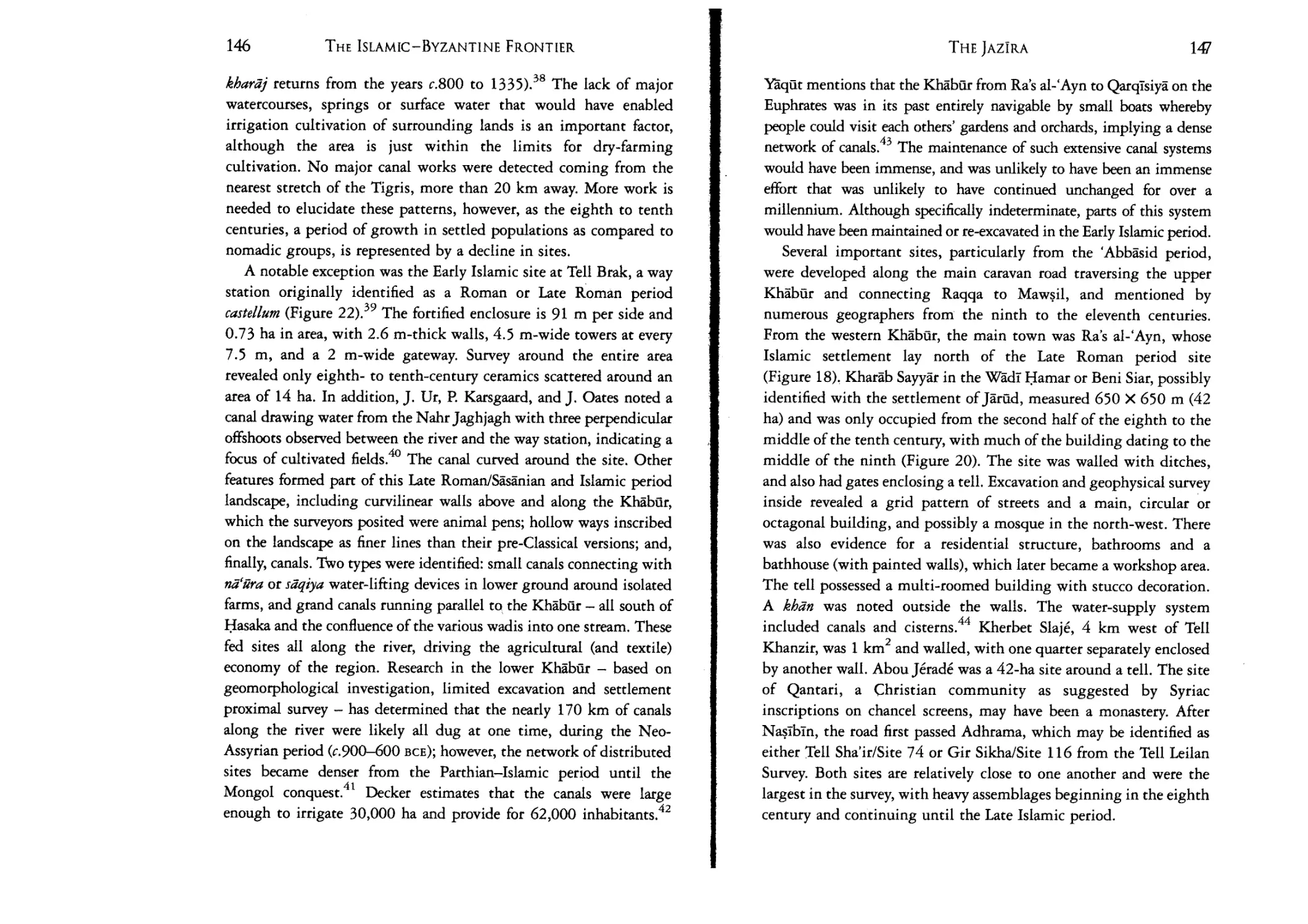
EGER
To my parents
You should knowthat an area does notbecome illustrious bythe nembe« of its
settlements, but rather by the importance of its rural districts
Paperback edition published in 2017 by
LB.Tauris & Co. Ltd
London • New York
www.ibrauris.corn
Hardback edition first published in 201 S by
LB.Tauris & Co, Lrd
Copyright © 2015 A. Asa Eger
The right of A. Ass Ager to be identified as the author of this work has been asserted
by the author in accordance with the Copyright, Designs and Patents Act 1988.
All rights reserved. Except for brief quotations in a review, this book, or any part
thereof, may not be reproduced, stored in or introduced into a retrieval system,
or transmitted, in any form or by any means, electronic, mechanical, photocopying,
recording or otherwise, without the prior written permission of the publisher.
Every attempt has been made to gain permission for the use of the images in this book.
Any omissions will be rectified in future editions
References to websites were correct at the time of writing.
ISBN: 978 1 78453 919 1
eISBN: 978 0
674 1
ePDF: 978085772 685 8
A full CIP record for this book is available from the British Library
A full CIP record is available from the Library of Congress
Library of Congress Caralog Card Number: available
Typeset in Garamond Three by OKS Prepress Services, Chennai, India
Printed and bound by CPI Group (UK) Ltd, Croydon, CRO 4YY
Muqaddasi, Aksan al-taqasfm ff ma'rifa: al-iqltm, 1906, p. 228.
Translation by Basil Collins, The Best Divisions for the Knowledge of
Regions, 2001, p. 189.
CONTENTS
List of Figures and Tables
Acknowledgements
List of Abbreviations
Introduction
Part 1.
Islamic Frontiers, Real and Imagined
The Syro-Anatolian Thughur
IX
Xll
xv
1
23
1.
The Central Tbugbiir: The Two Amuqs
33
2.
The Central Thughilr: The Steppe and the River
69
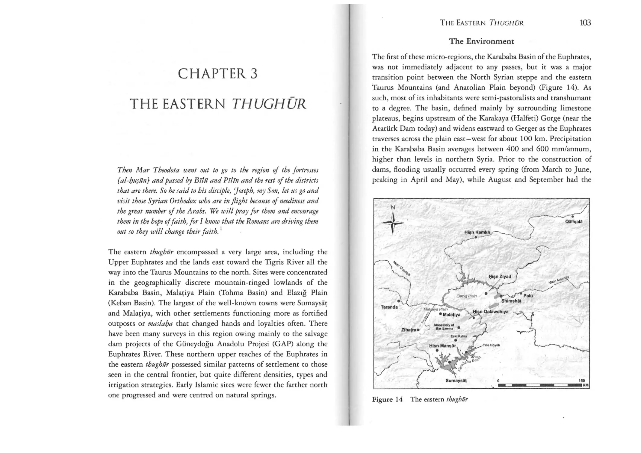
3.
The Eastern Thughilr
102
4.
The JazIra (Balikh and Khabiir River Valleys)
127
5.
The Western Thughilr: Crossroads of Cilicia
158
Part 2 Hydraulic Villages and Fortified Castles:
A Narrative of Settlement
183
6.
7.
8.
Prologue: Upland Settlements in the Late Roman
Period (Fourth to Seventh Centuries)
187
Hydraulic Villages in the Early Islamic Period
(Seventh to Tenth Centuries)
198
The Byzantine Frontier (Seventh to Tenth Centuries)
246
THE ISLAMIC-BYZANTINE FRONTIER
VIII
9.
Epilogue: Fortified Castles of the Middle Islamic/Middle
Byzantine Period (Tenth to Fourteenth Centuries)
264
10. Frontier or Frontiers? Interaction and Exchange in
Frontier Societies
277
Conclusions
310
Notes
Bibliography
Index
Dismantling and Rebuilding the Frontier
315
F
371
400
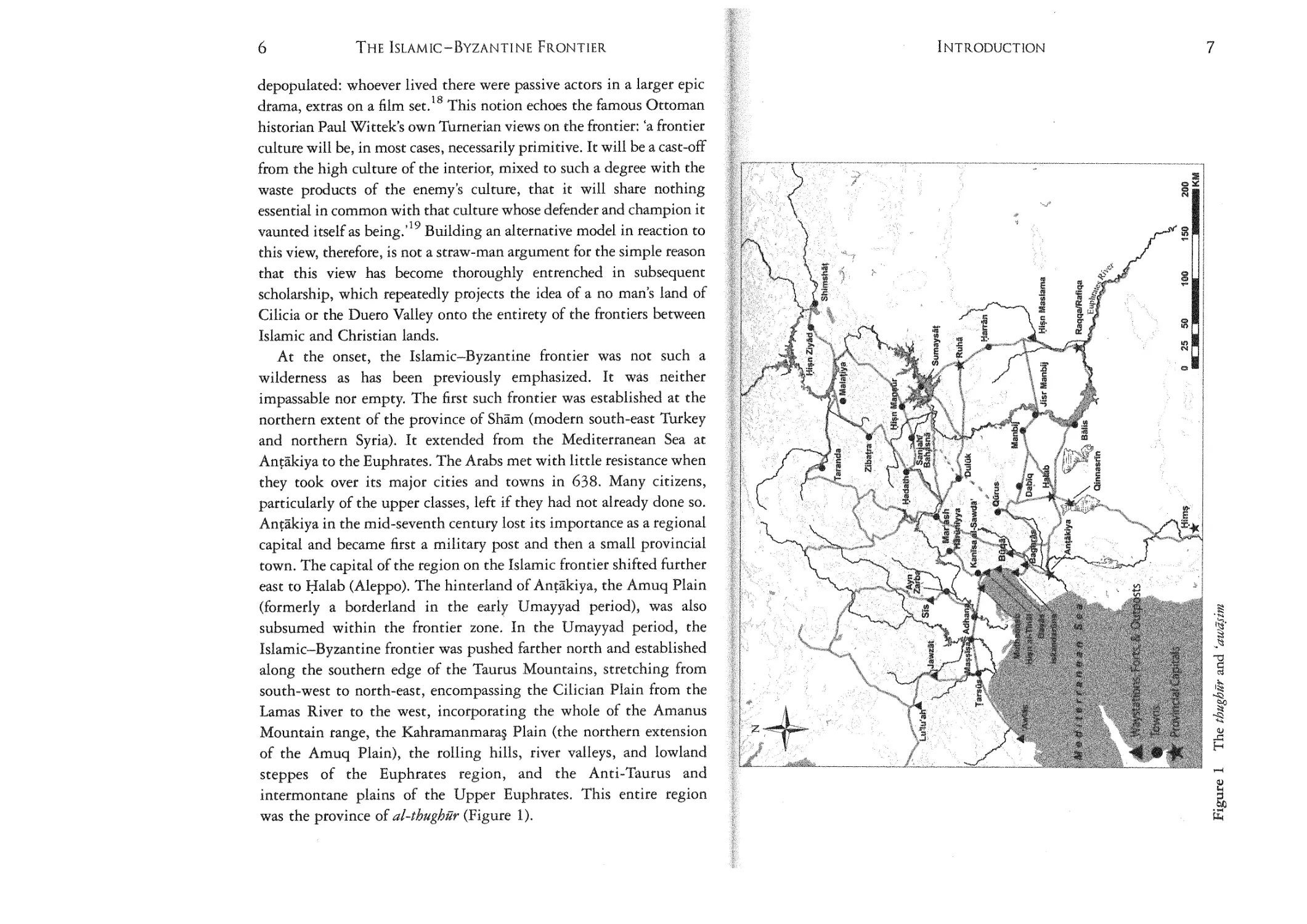
Figure 1: The thughilr and
(awa~im
7
2: Tribes on the thughur
3: The thughur with natural features represented
4: The Central thttghilr
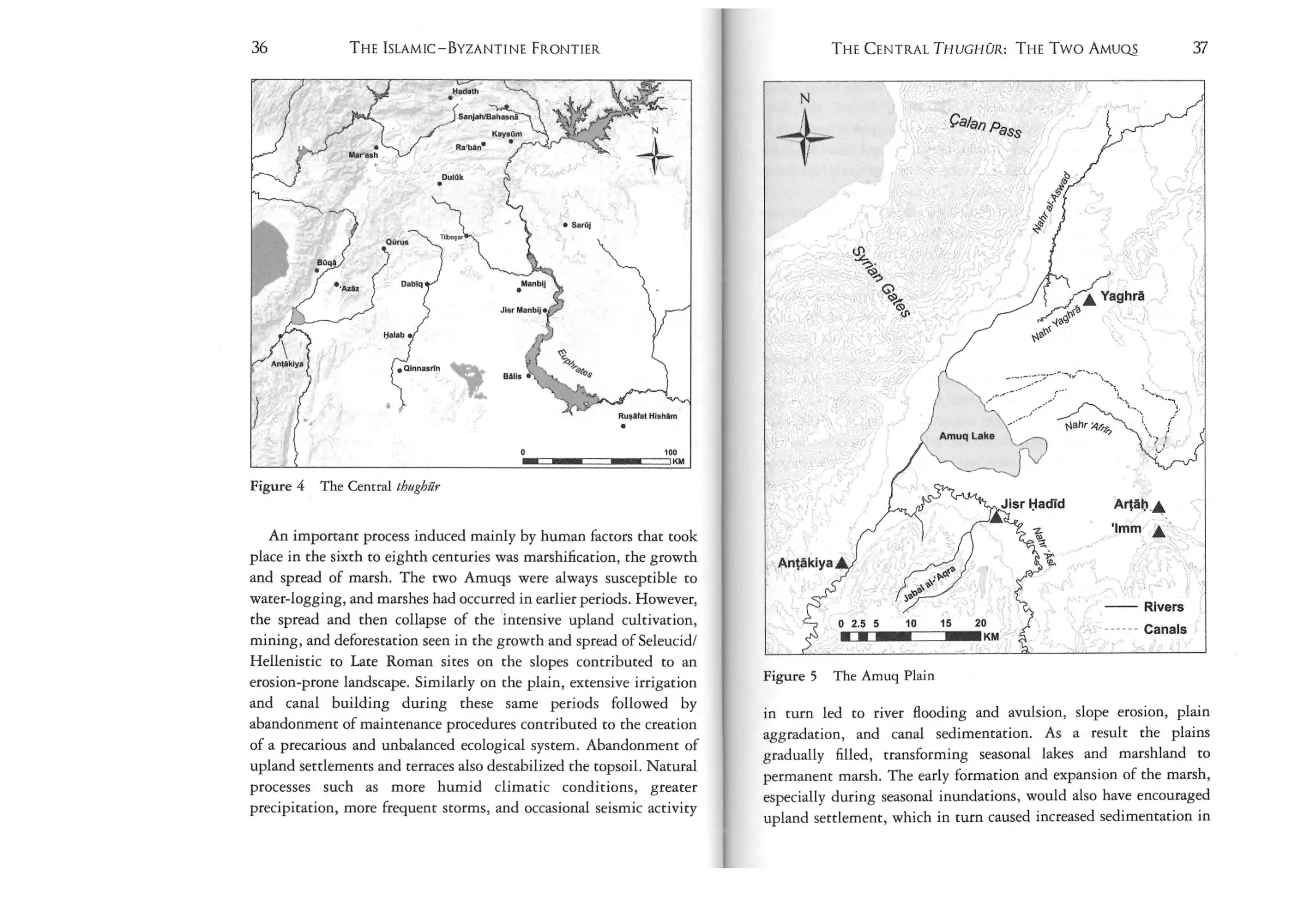
Figure 5: The Amuq Plain
37
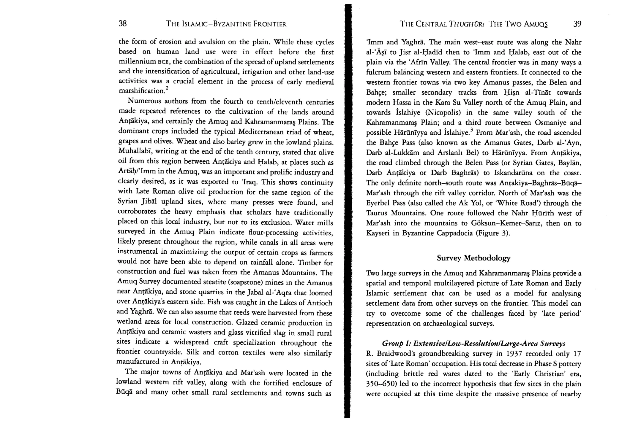
Figure 6: The Amuq Plain, Late Roman through
Middle Islamic sites
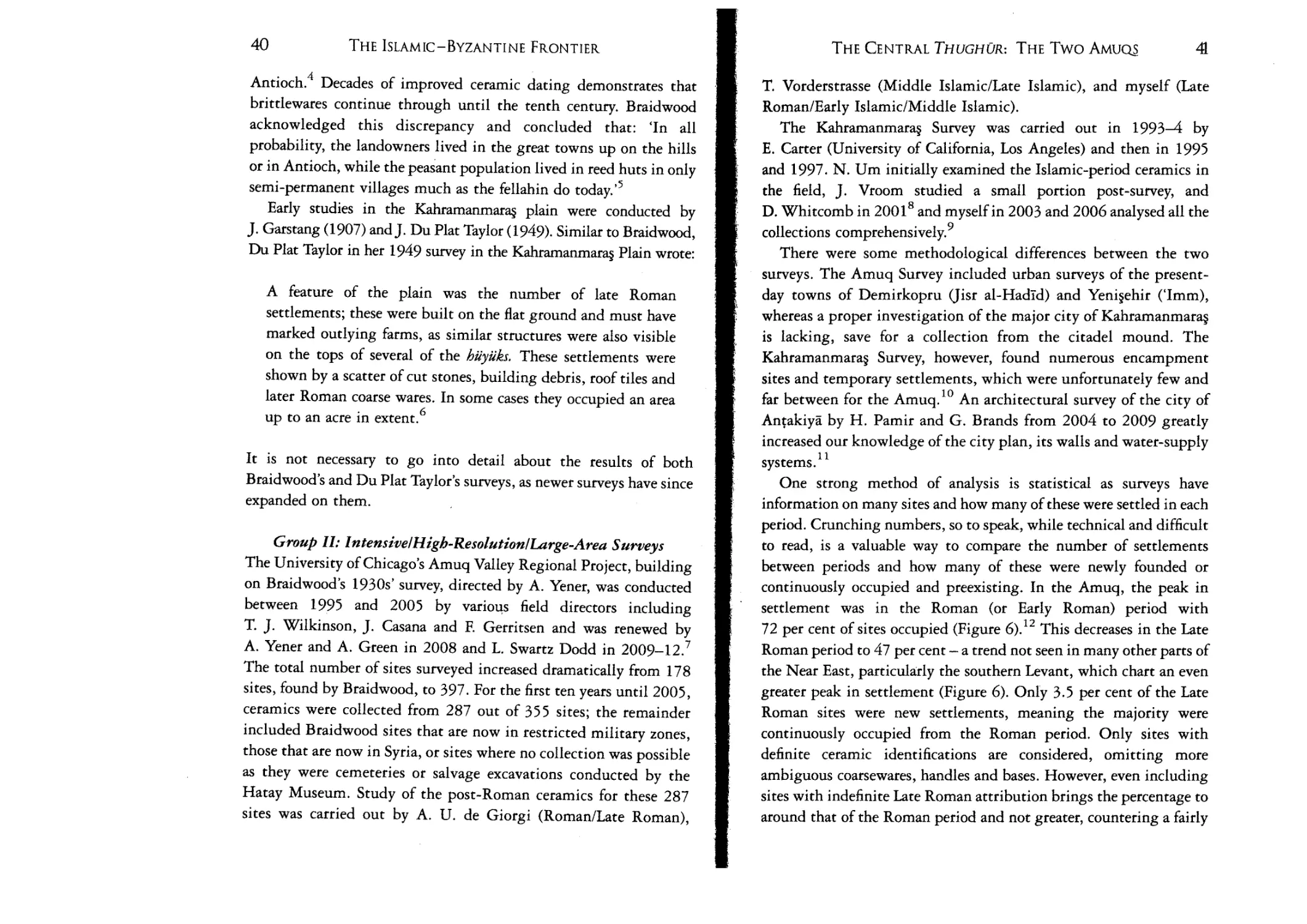
7: The Kahrarnanmaras Plain, Early Islamic through
Middle Islamic sites
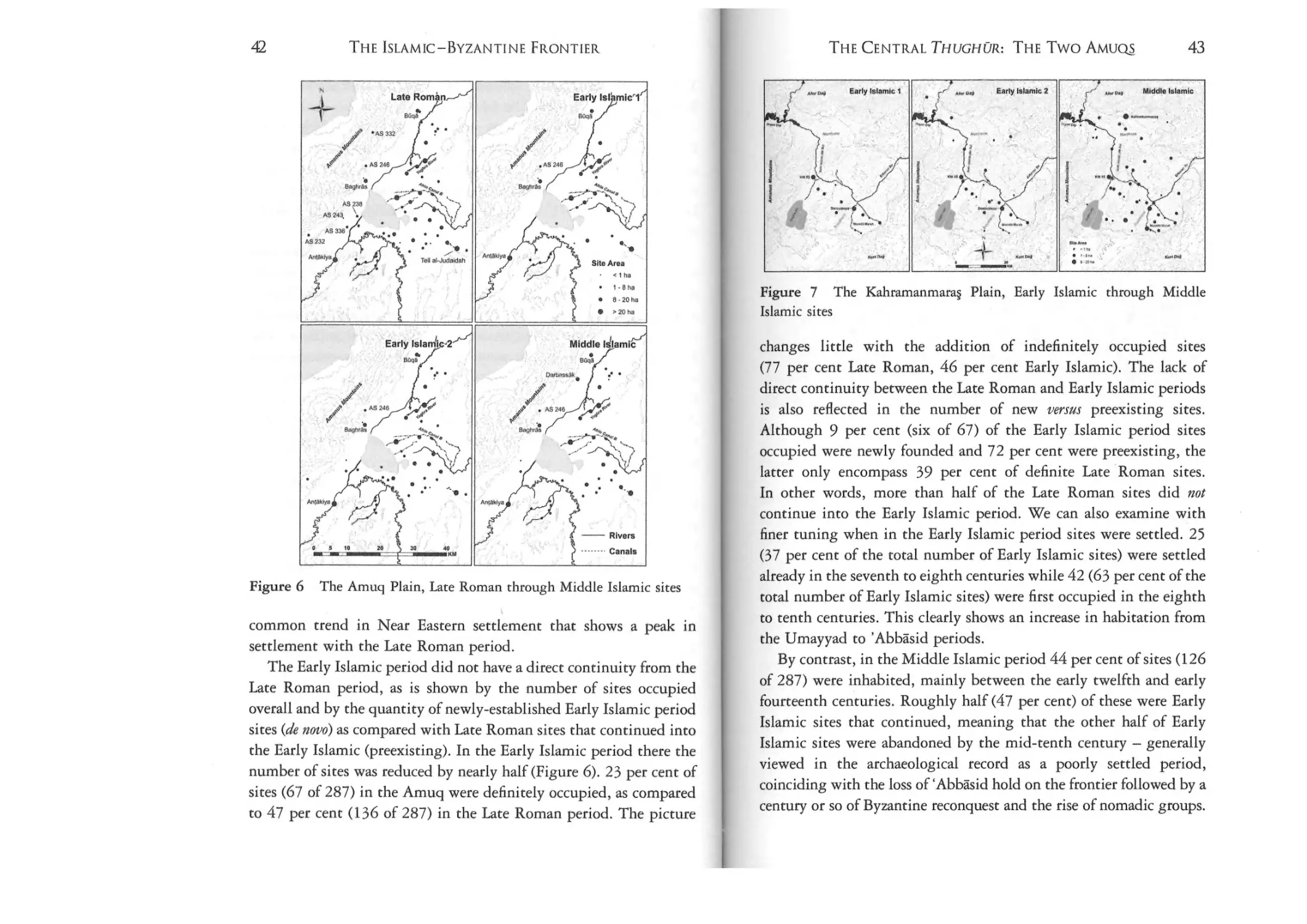
8:
the Late Roman and Early Islamic
excavated building (photo courtesy of S. Campbell)
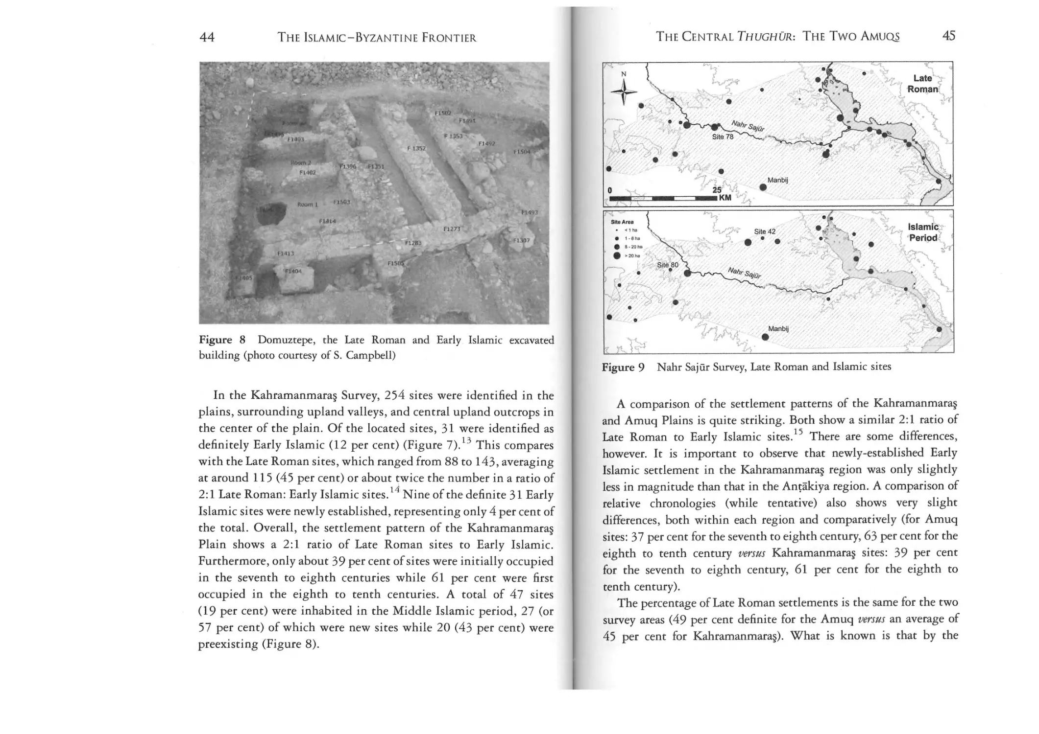
9: Nahr Sajur Survey, Late Roman and Islamic sites
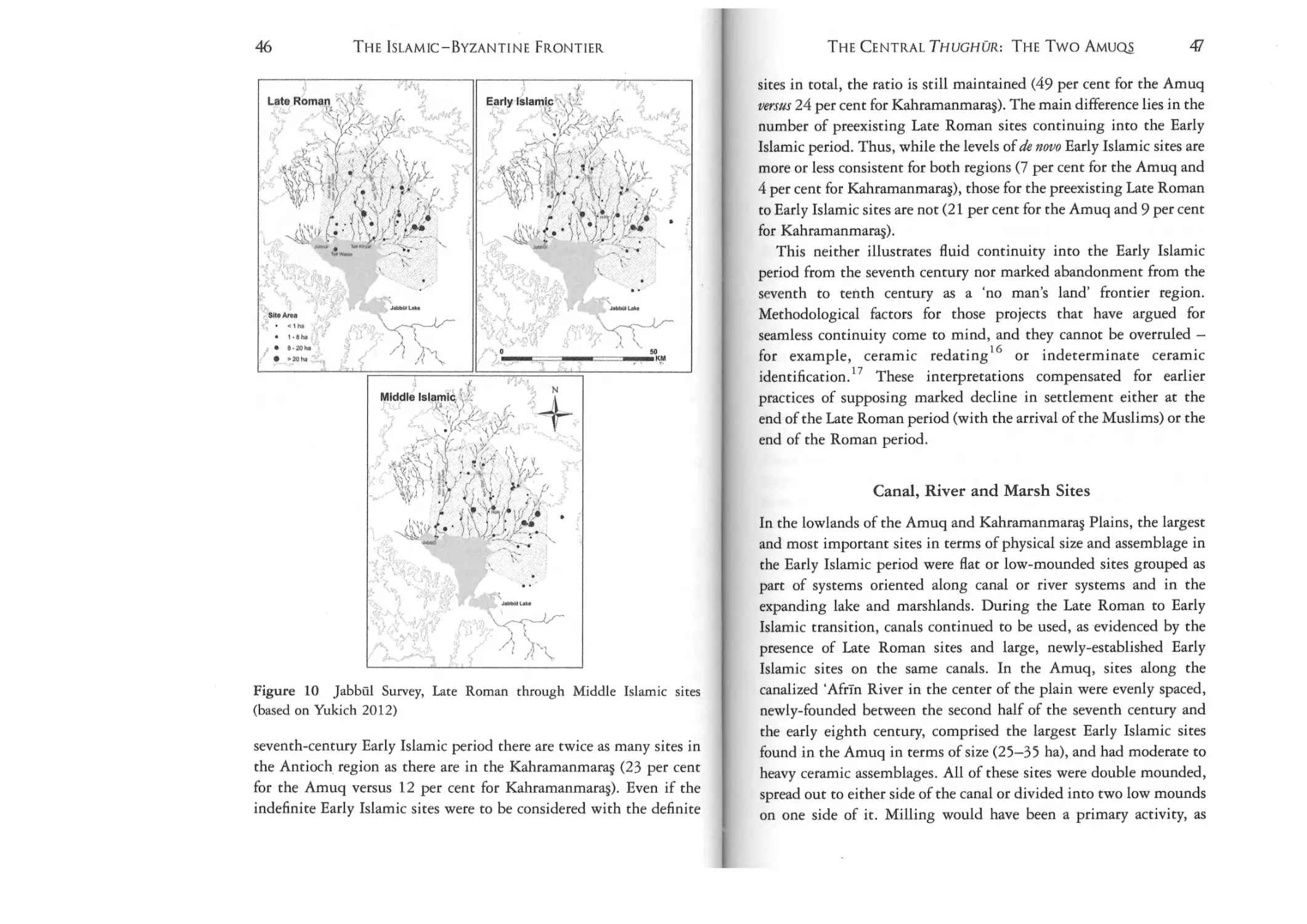
10: jabbul Survey, Late Roman through Middle
Islamic sites (based on Yukich 2012)
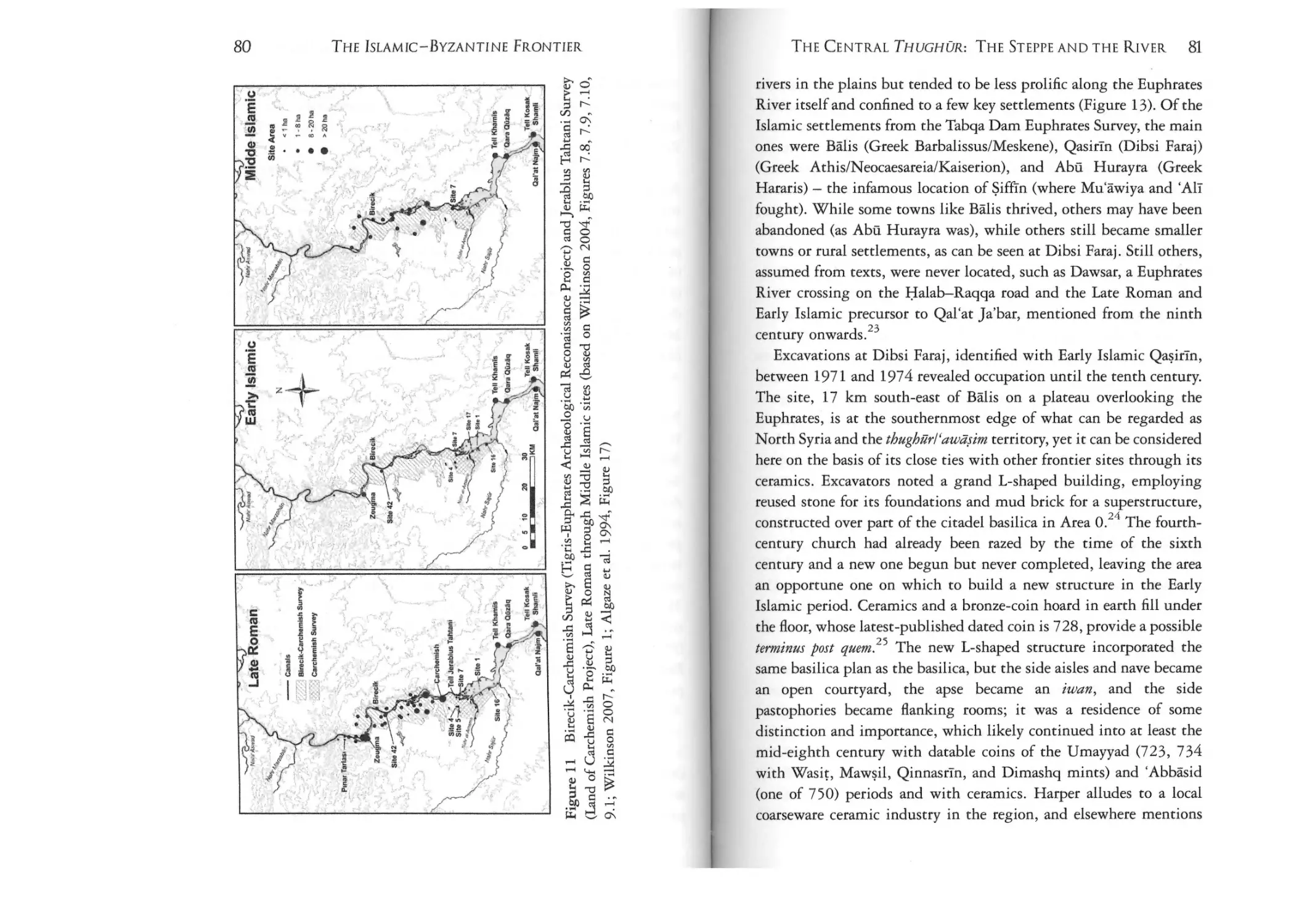
Figure 11: Birecik-Carchernish Survey (Tigris-Euphrates
Archaeological Reconaissance Project) and jerablus Tahtani
Survey (Land of Carchemish Project), Late Roman through
46
x
THE ISLAMiC-BYZANTINE FRONTIER
Middle Islamic sites (based on Wilkinson 2004, Figures 7.8,
7.9,7.10,9.1; Wilkinson 2007, Figure 1; Algaze et al.
1994, Figure 17)
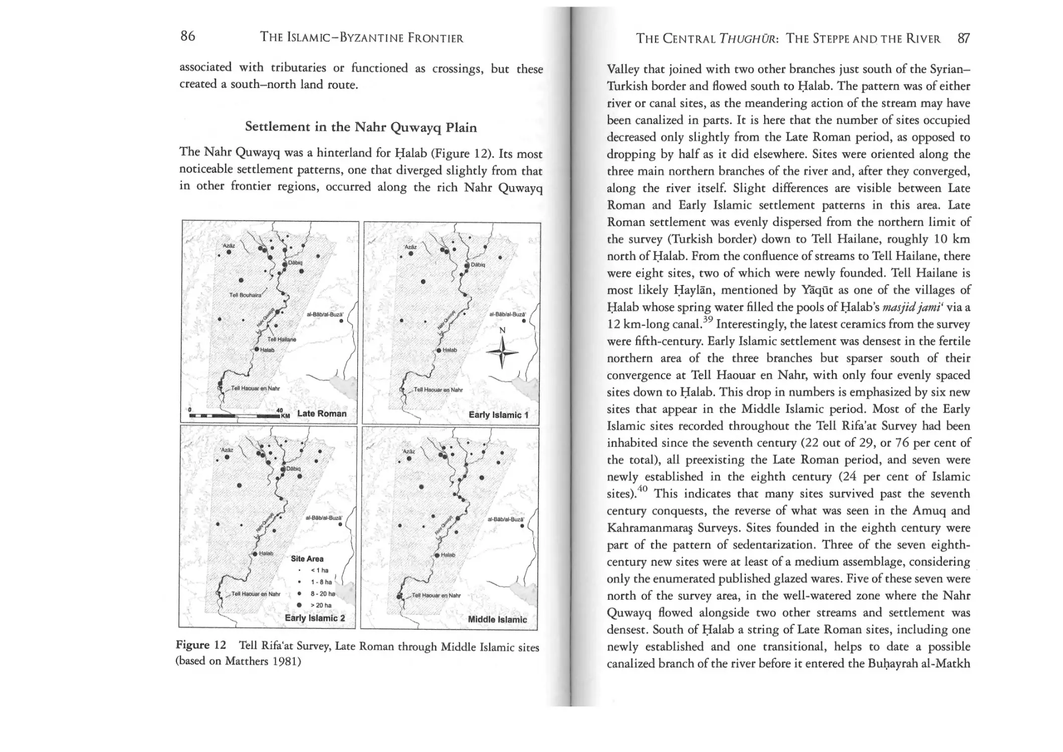
LIST OF FIGURES AND TABLES
XI
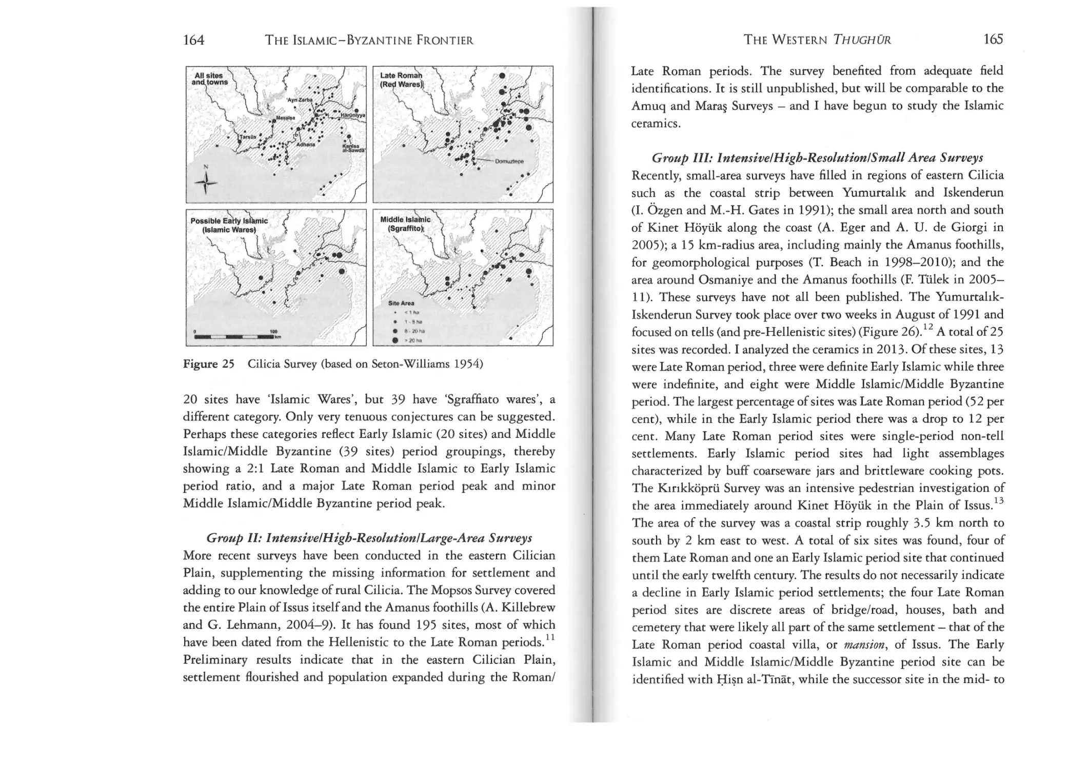
Figure 25: Cilicia Survey (based on Seton-Williams 1954)
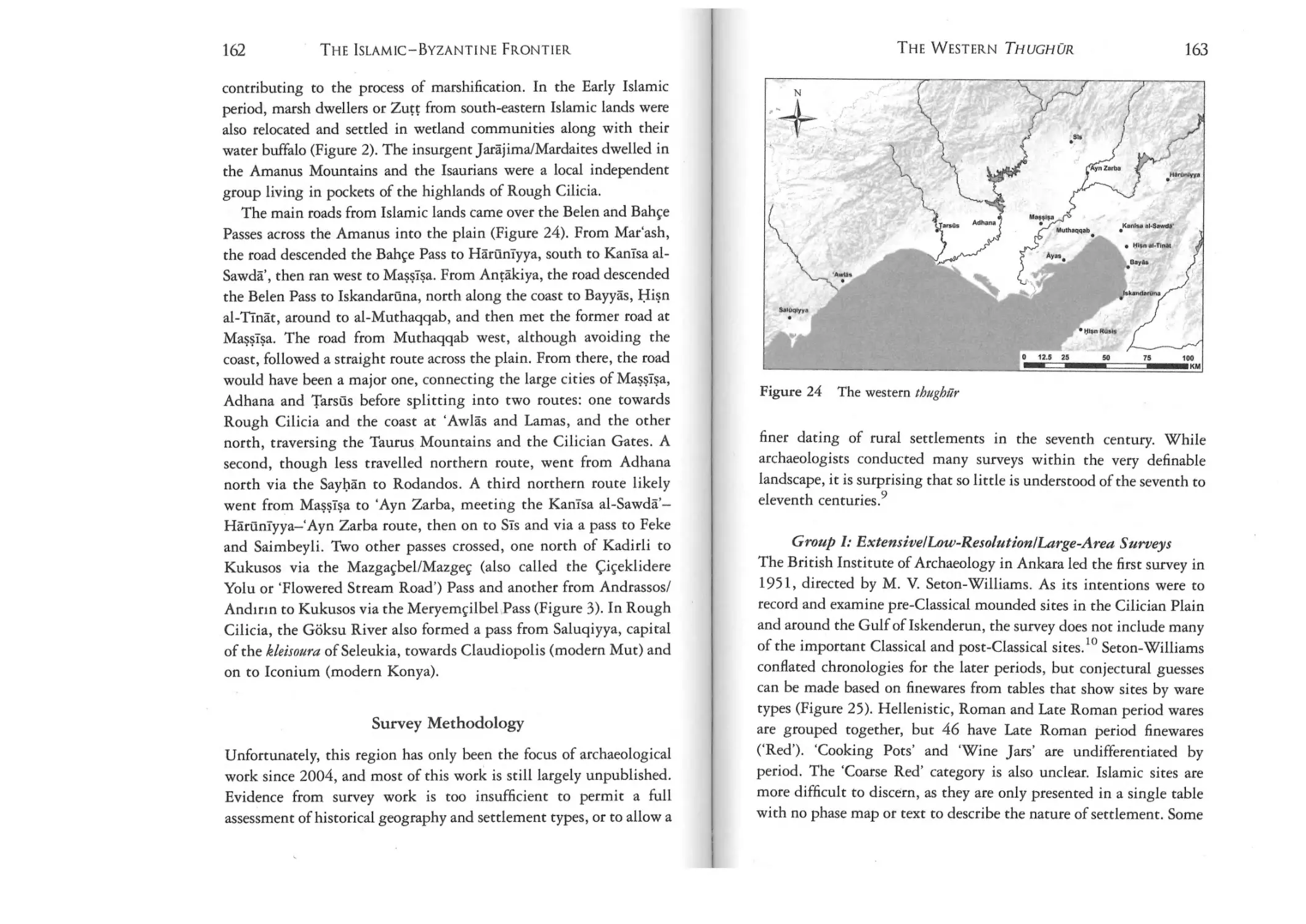
164
80
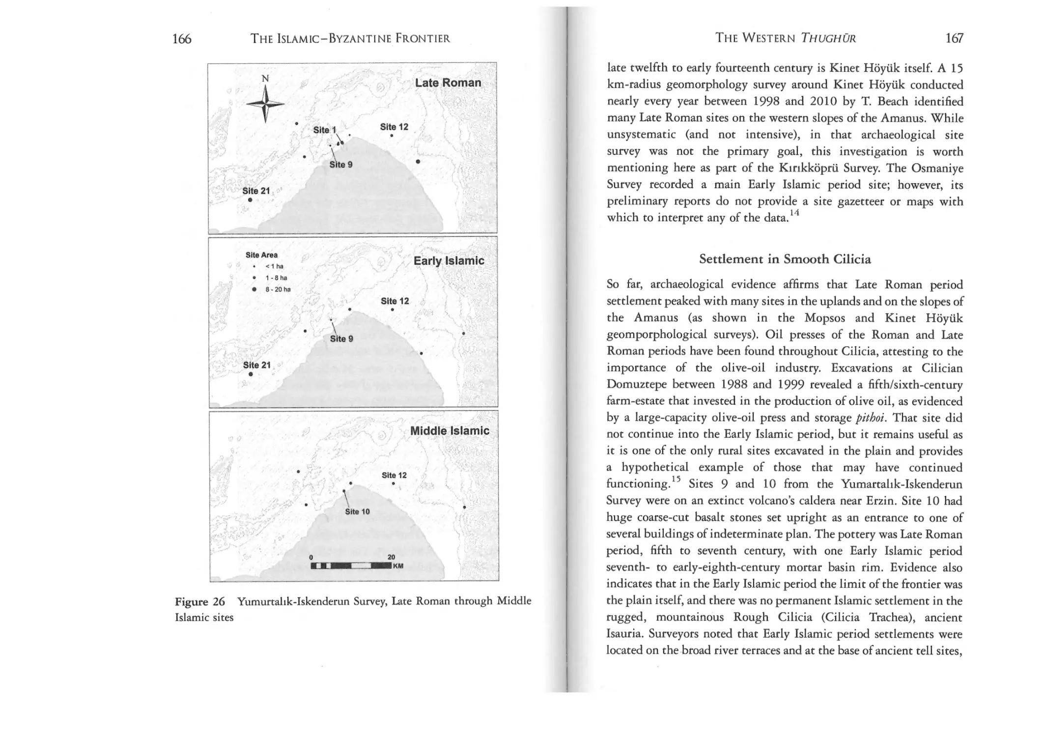
Figure 26: Yumurtalik-Iskenderun Survey, Late Roman
through Middle Islamic sites
166
Figure 12: Tell Rifa'ar Survey, Late Roman through
Middle Islamic sites (based on Matthers 1981)
86
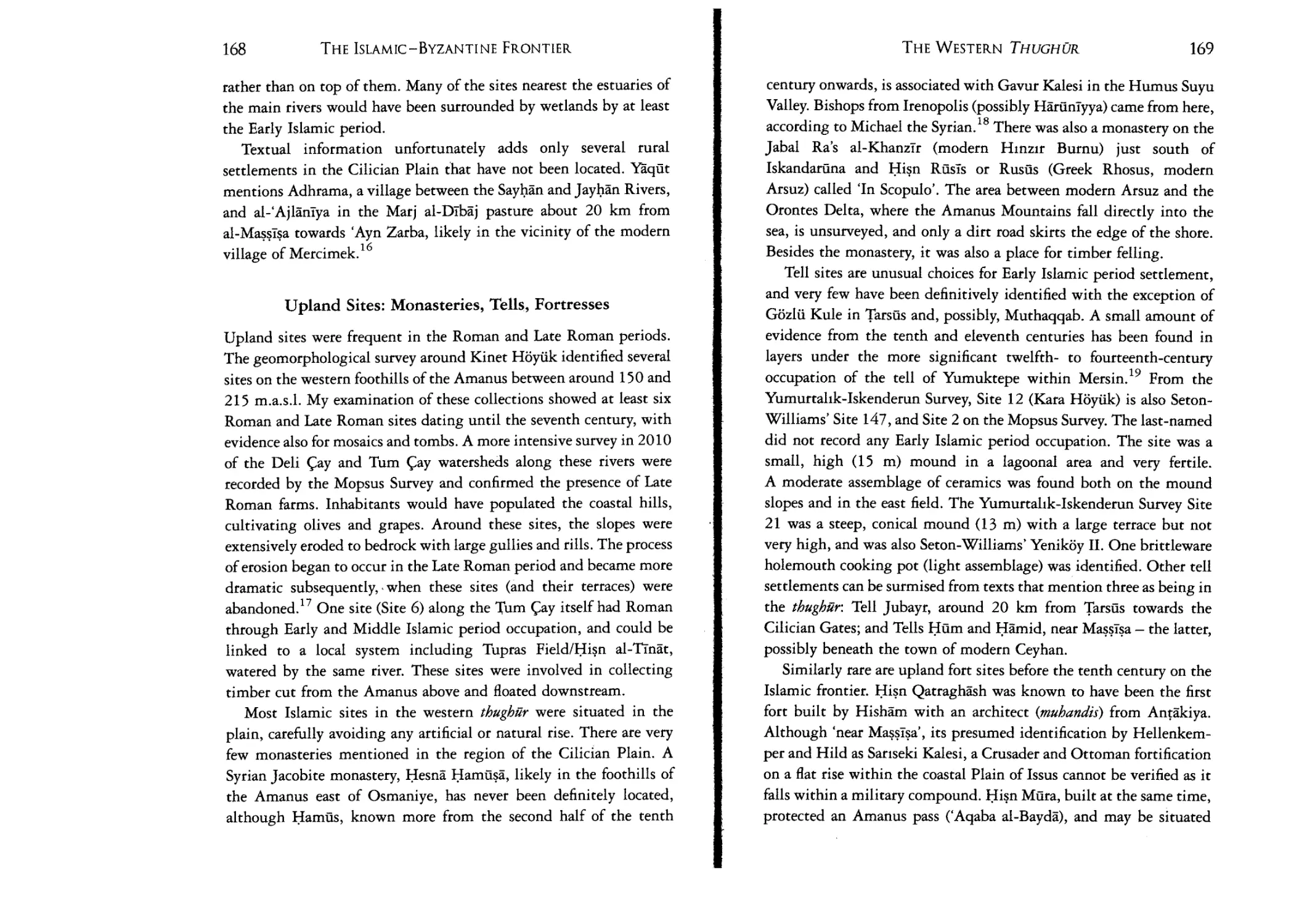
Figure 27: Tupras Field/Hisn al-Tinat, eastern gate and
internal rooms (courtesy of M.-H. Gates)
172
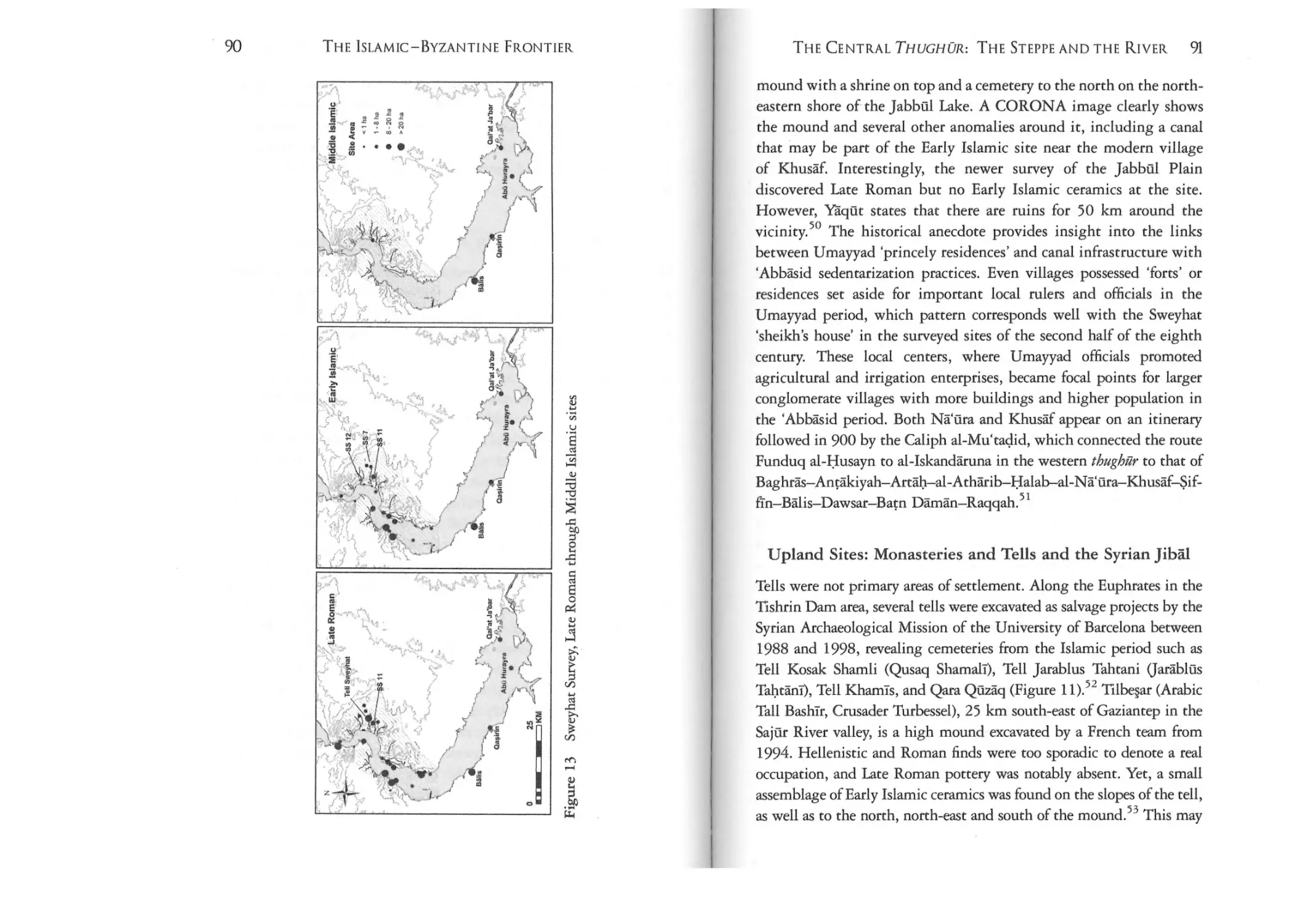
Figure 13: Sweyhat Survey, Late Roman through Middle
Islamic sites
90
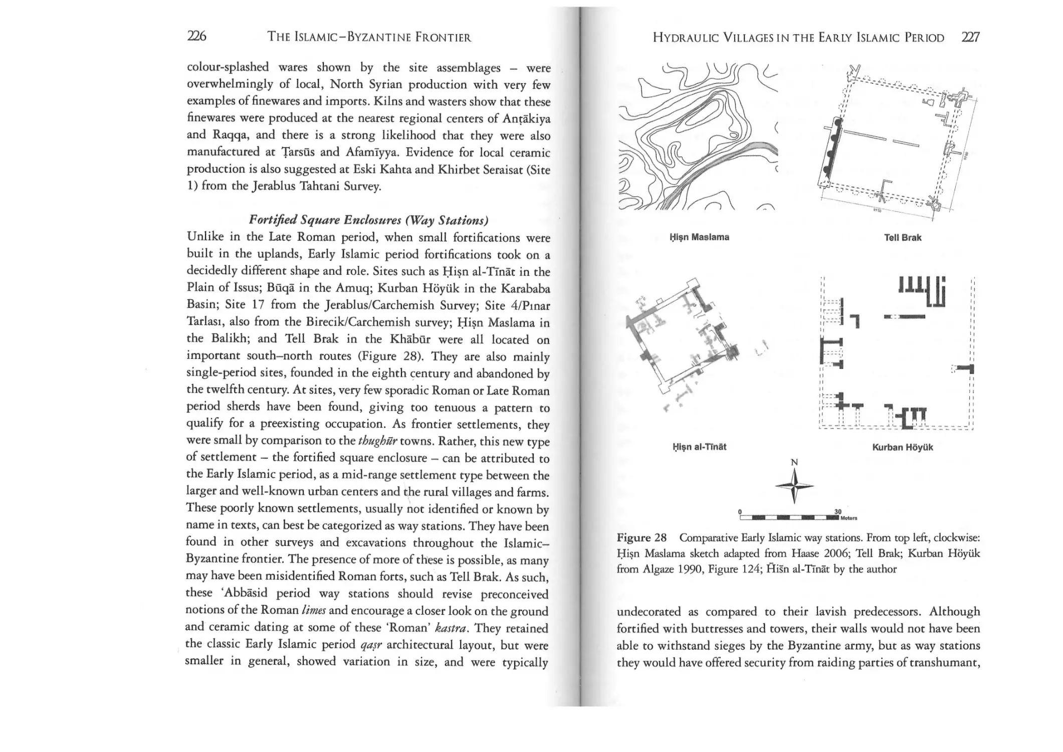
Figure 28: Comparative Early Islamic way stations. From
top left, clockwise: Hisn Maslarna sketch adapted from
Haase 2006; Tell Brak; Kurban Hoytik from Algaze 1990,
Figure 124; Hisn al-Tinar by the author
227
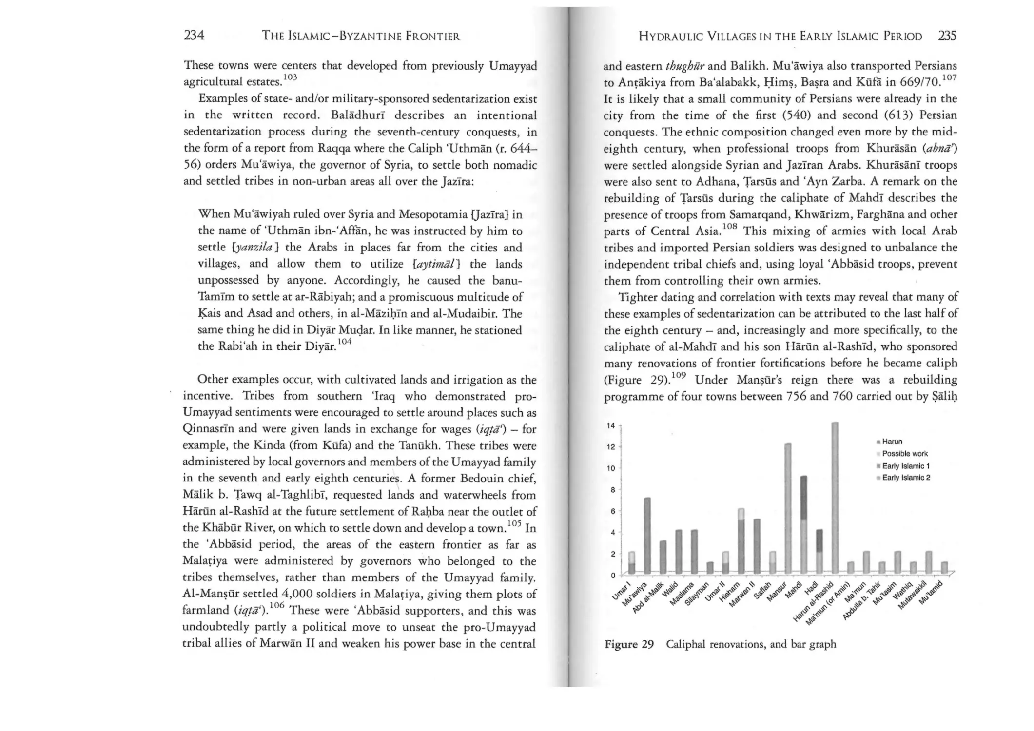
Figure 29: Caliphal renovations, and bar graph
235
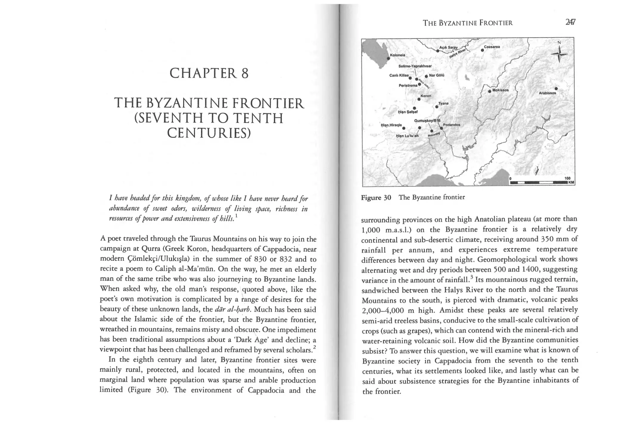
Figure 30: The Byzantine frontier
247
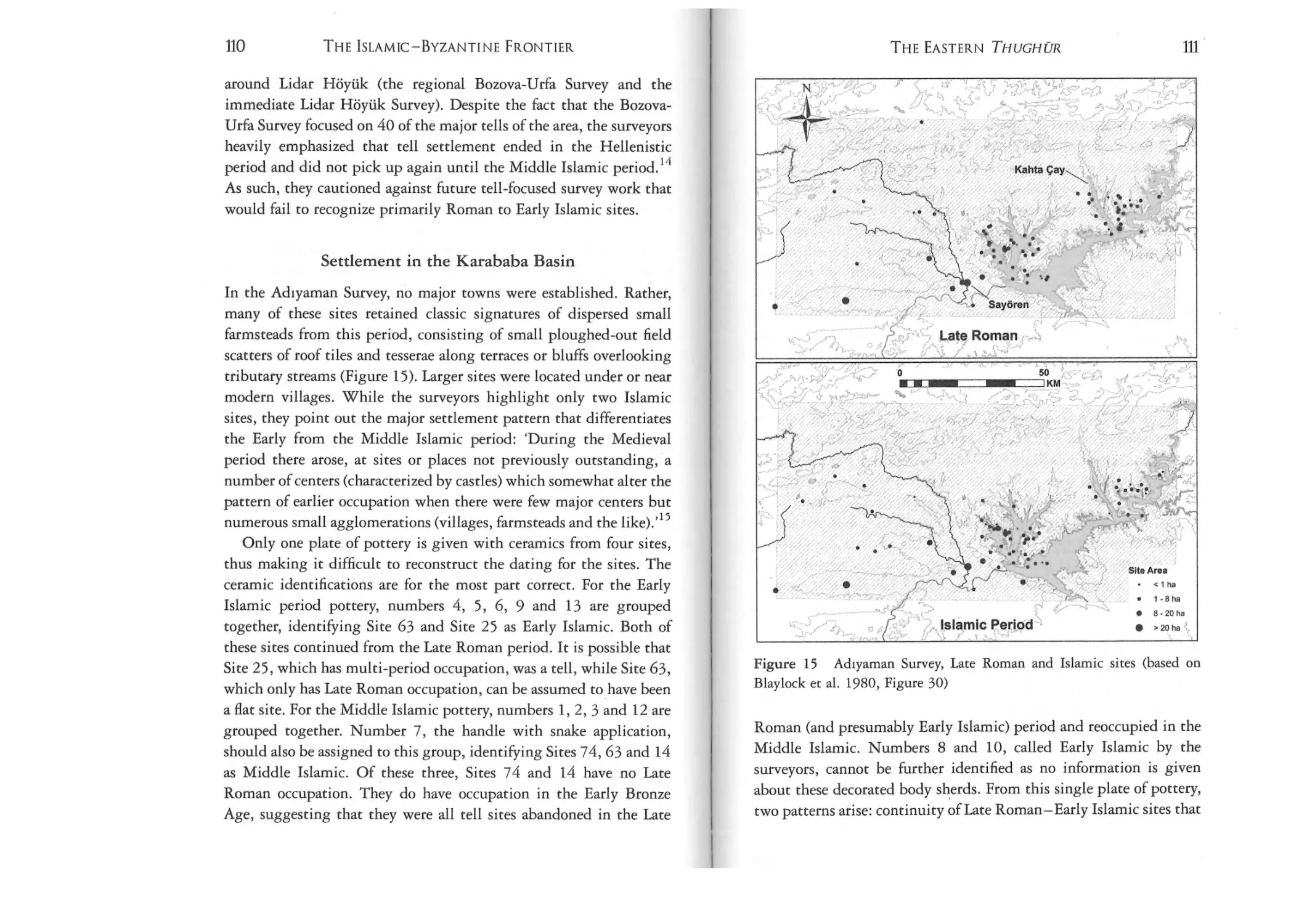
Figure 14: The eastern thughilr
Figure 15: Adiyaman Survey, Late Roman and Islamic sites
(based on Blaylock et al., 1980, Figure 30)
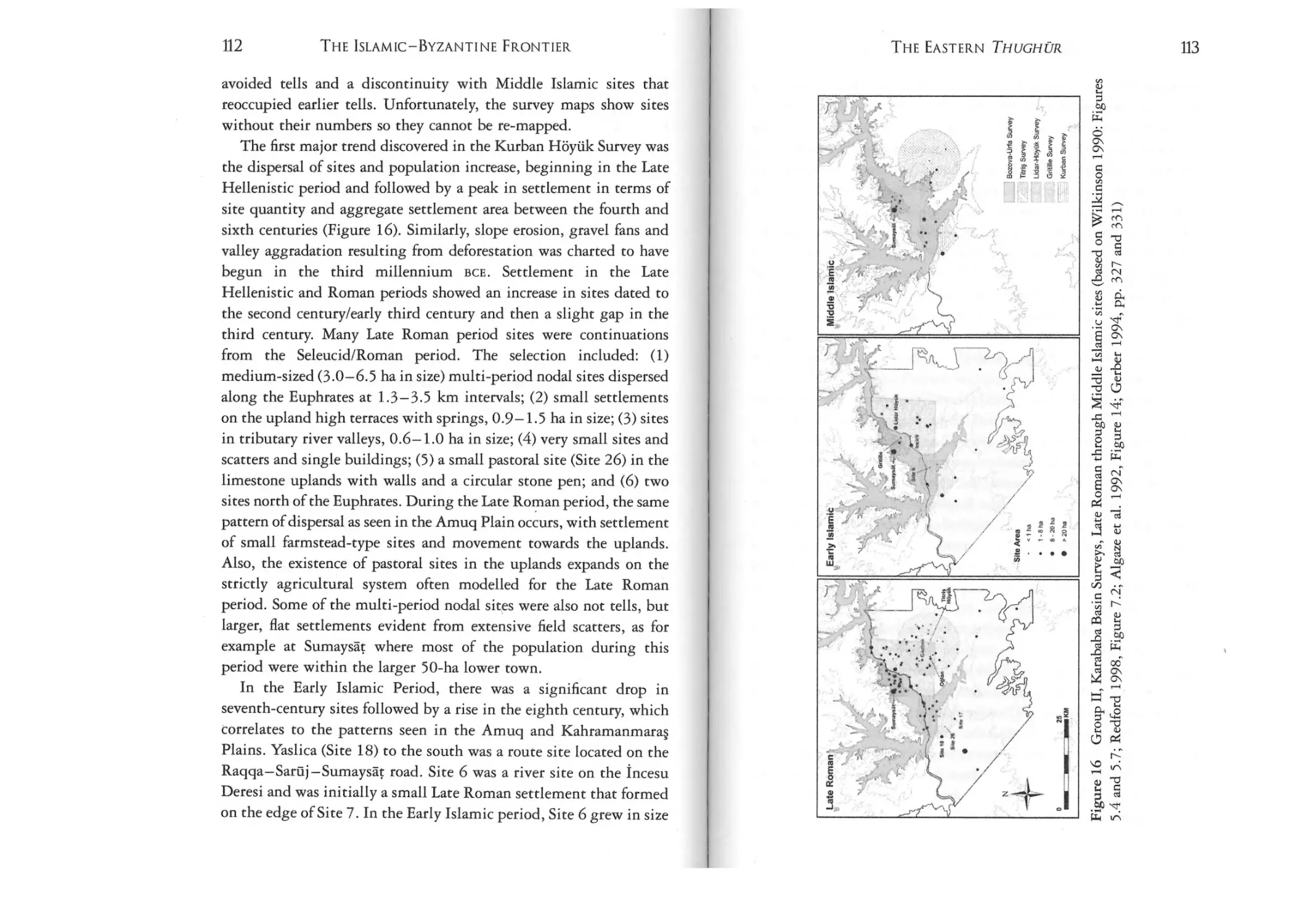
Figure 16: Group Il, Karababa Basin Surveys, Late Roman
through Middle Islamic sites (based on Wilkinson 1990:
Figures 5.4 and 5.7; Redford 1998, Figure 7.2; Algaze et al.
1992, Figure 14; Gerber 1994, pp. 327 and 331)
103
111
Tables
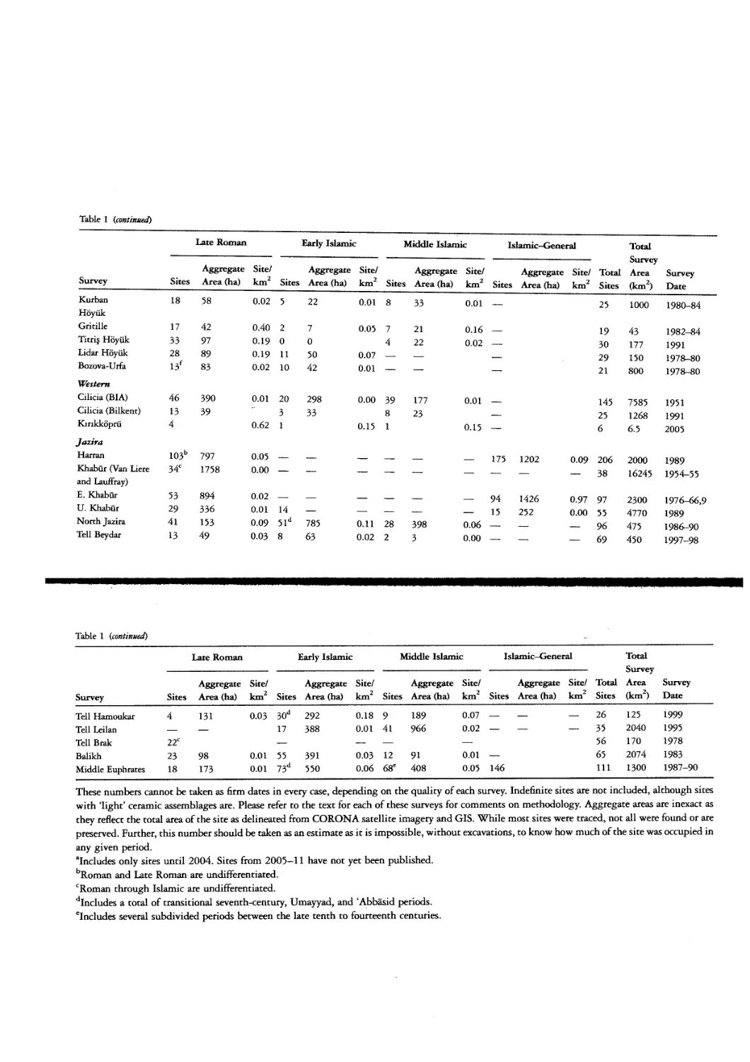
113
Table 1: Surveys on the thughilr, late period settlement
Figure 17: A§van and Alnnova Surveys, Byzantine and
Islamic sites (based on WhaIlon 1979, Figure 3)
120
Figure 18: The Jazlra
132
Figure 19: Harran Survey, Late Roman and Islamic sites
(based on Yardimci 2004, 393 and 394)
133
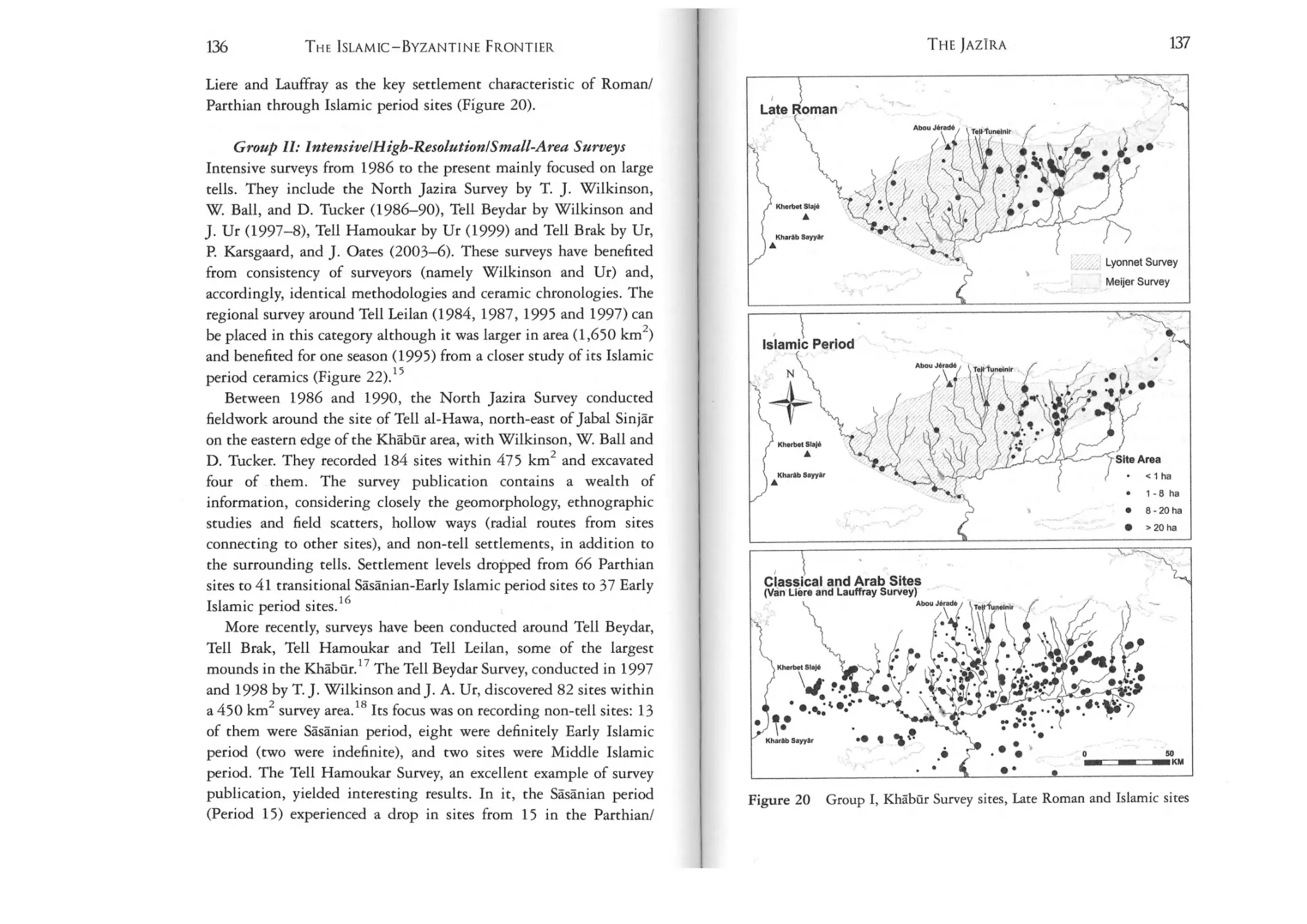
Figure 20: Group I, Khabur Survey sites, Late Roman
and Islamic sites
137
Figure 21: Balikh Survey, Late Roman through Middle
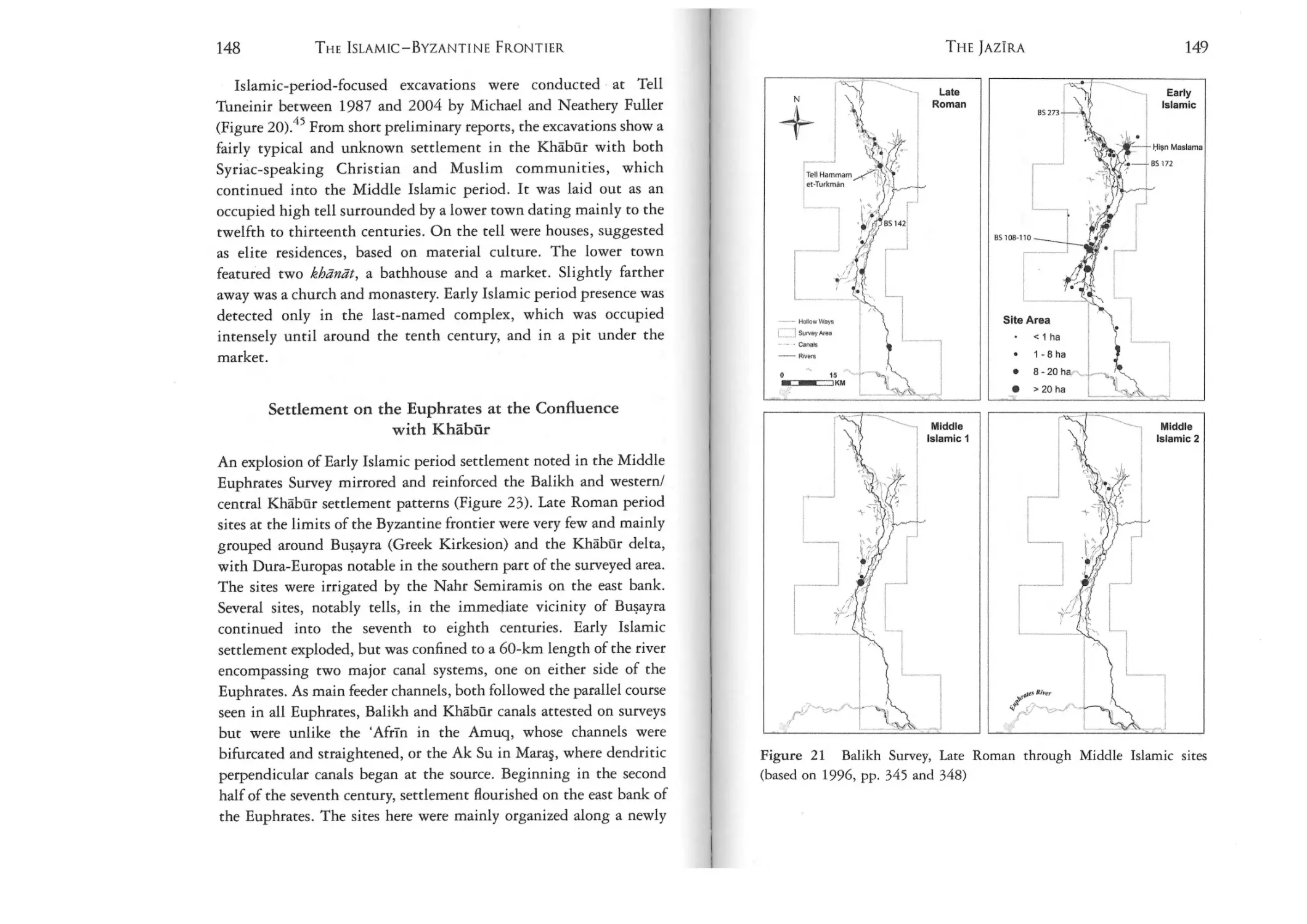
Islamic sites (based on 1996, pp. 345 and 348)
149
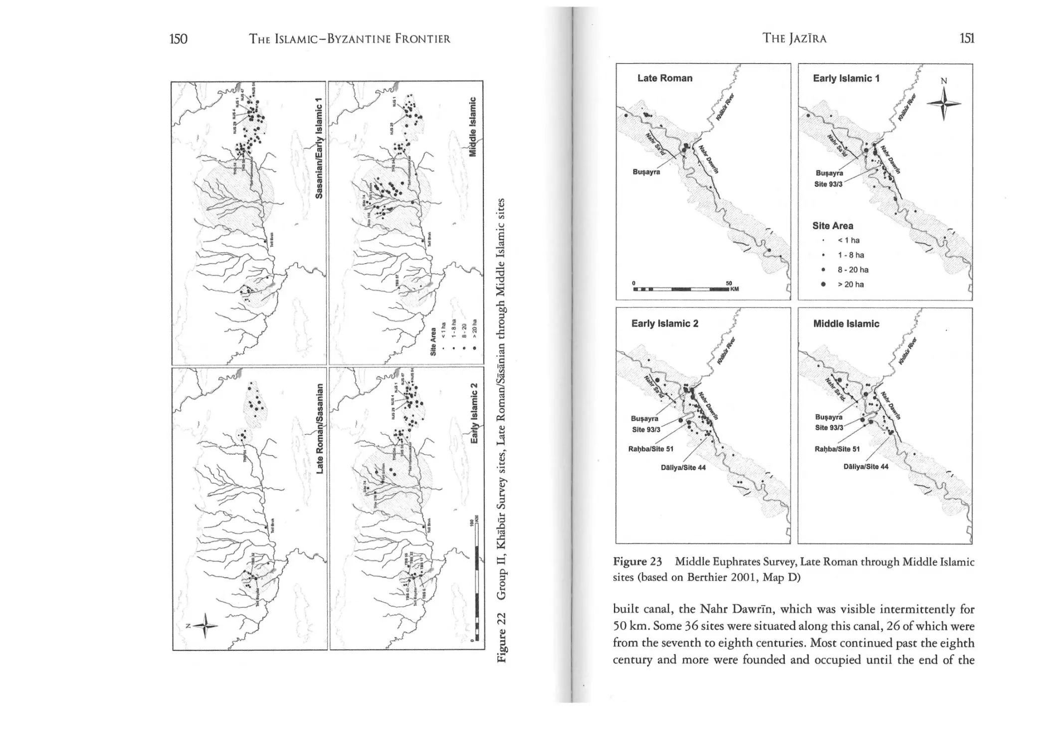
Figure 22: Group Il, Khabur Survey sites, Late
Rornan/Sasanian through Middle Islamic sites
150
Figure 23: Middle Euphrates Survey, Late Roman through
Middle Islamic sites (based on Berthier 2001, Map D)
151
Figure 24: The western thughilr
163
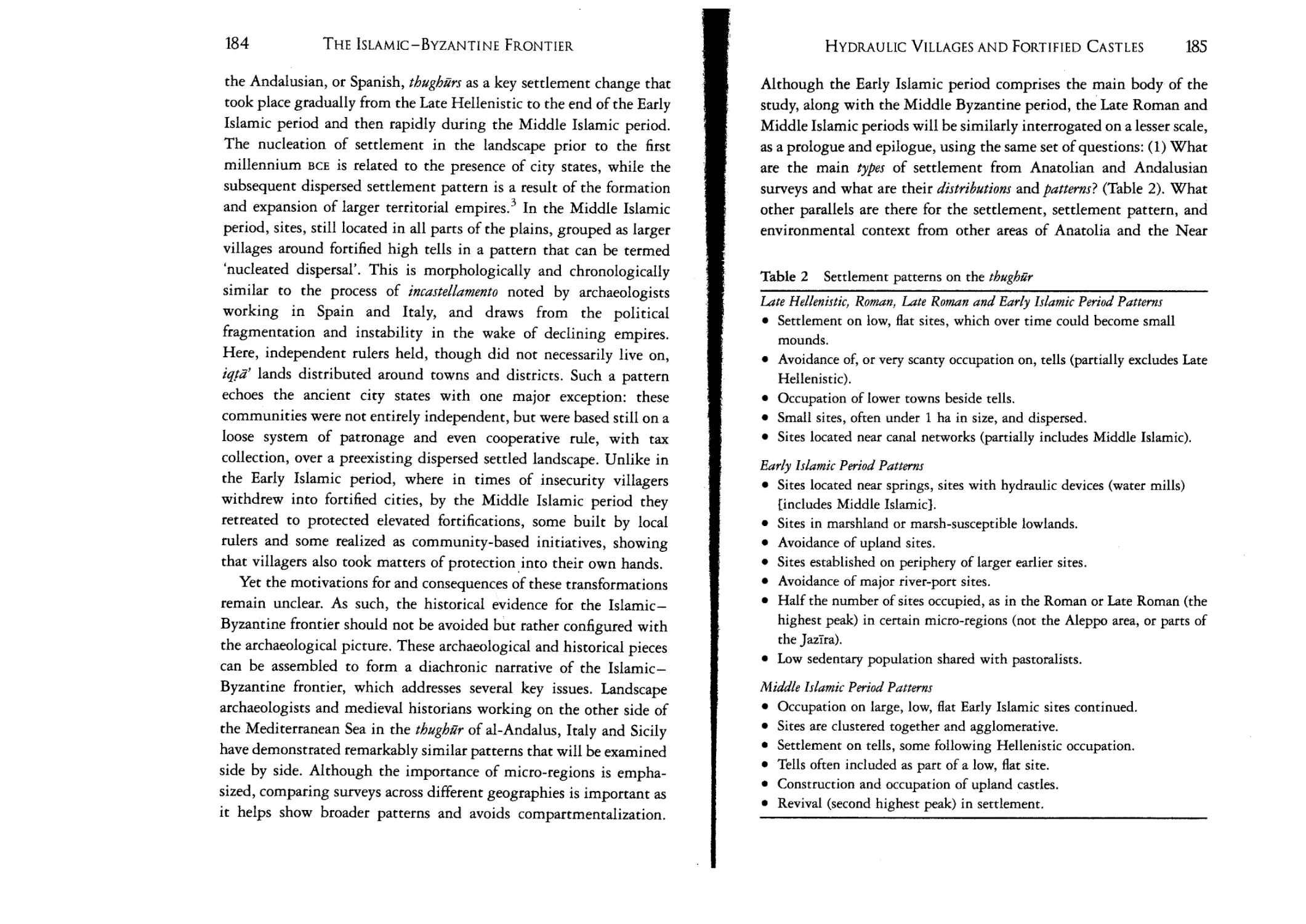
Table 2: Settlement patterns on the thughilr
29
185
ACKNOWLEDGEMENTS
ACKNOWLEDGEMENTS
If one looks hard enough, one can see just about anything. A patch
of grass, when stared at for hours, is still an unremarkable patch of
grass. Yet when one gets down on hands and knees, an entire
microcosm unfolds, a multitude of creatures moving around and
interacting with one another, and with the growing world around
them. This book first began as an unnamed, unremarkable lowmounded patch of land, AS 257, that I surveyed along with other
members of my team in 2001 in the Amuq Valley. The site soon
turned out to be quite revealing. It was one of three, evenly spaced
along a canal and newly founded in the seventh century. The canal
was among several channels irrigating the Amuq Valley and in one
of many lowland plains settled, irrigated and cultivated on the
Islamic-Byzantine frontier. So my interest expanded and took
shape, initially as a dissertation and finally into a study of the
landscape of the entirety of the frontier and its neighbouring lands.
Not a microcosm.
The entire process is the product of much wonderful collaboration
and could not have been done without the inspiration, motivation,
assistance and cooperation of a large and significant group of
individuals. From the onset, I would like to thank my incredible
University of Chicago dissertation committee: my advisor Donald
Whitcomb, Fred Dormer and Waiter Kaegi, all three of whom have
returned to the thttghur many times throughout their scholarship and
XLII
together formed the perfect team. I would also like to thank Adam
Smith, who, as an outside reader, provided an important
anthropological perspective on the research. In the field, my list of
colleagues to whom I owe great debts of gratitude is happily long,
and to name but a select few: Tony Wilkinson, Jesse Casana, Aslihan
Yener, David Schloen, Fokke Gerritsen, Rana Ozbal, Tasha
Vorderstrasse, Timothy Harrison, Steve Batiuk and Arnir Surnak'ai
Fink for the Amuq survey; Liz Carter, Stuart Campbell, Liz Mullane,
Mhairi Campbell, Claire Heywood, Ben Gearey, Will Fletcher and
Kate Grossman for the Maras Survey; and Marie-Henriette Gates,
Fran Cole, Salima Ikrarn, Ben Claasz Coockson, Rado Kabatiarova,
Tim Beach, Canan Cakirlar, Carolyn Swan and the tireless Turkish
and American undergraduates for the Tupras Field survey and
excavations. Many people who have provided me along the way with
useful insighrs and comments great and small must be thanked:
Hugh Kennedy, McGuire Gibson, Gil Stein, Scott Branring, Seth
Richardson,John Woods, Carrie Hritz, Linda Wheatley-Irving, Rana
Mikati, and Derek Krueger; and my support group while at Chicago:
Alyssa Gabbay, Pat Wing, Mayte Green, Adrian de Gins, Vanessa de
Gins, Jonathan Brown, Yuval ben Bassat, Nukhet Varhk and
Noha Forster.
This book was largely written during my stay as a Fellow at
Dumbarton Oaks in the spring of 2012. My fellow Byzantine
Fellows, lovingly strengthened by Margaret Mullett and the larger
Dumbarton Oaks community, provided stimulating conversations.
The library and gardens formed a perfect setting in which to write on
landscapes. In particular, this book could not have been completed
without the meticulous comments of John Haldon and the second
anonymous reviewer throughout. Andrea de Giorgi, Lynn Swartz
Dodd, Ian Straughn, ]ason Ur, Gunder Vannlioglu, Michael Decker,
Charles Gates, Stephen McPhillips, Bethany Walker and Alyssa
Gabbay all provided comments, corrections, citations and clarity to
individual chapters. Many thanks are also due to Ad Lukas, Luke
Kaiser, Claire Ebert and Reed Goodwin for assistance with producing
the geographic information system-based maps and to Kyle Brunner,
Ian McDonald, Maria Marsh, and Allison Walker for all their help in
XIV
THE ISLAMIC-BYZANTINE FRONTIER
editing. A last note of gratitude is for my family and friends, whose
persistent support and encouragement was boundless and enabled me
to traverse this frontier wilderness, this excellent country, these
beautiful lands, with their parts untamed and parts organized,
teeming with activity.
LIST OF ABBREVIATIONS
AST
Borders Barriers
Byzantine Trade
Castrurn 3
Cast rum 7
Arajttrma Sonuclart Toplanttss,
Borders, Barriers, and Etbnogenesis: Frontiers
in LateAntiquity and theMiddle Ages, edited
by F. Curta (Turnhout: Brepols, 2005).
Byzantine Trade, 4th-12th Centuries: The
Archaeology of Local, Regional and International Exchange. Papers of the thirtyeighth Spring Symposium of Byzantine
Studies, St. John's College, University of
Oxford, March 2004. Edited by Marlia
Mundell Mango (Burlingron, VT: Ashgate
Variorum, 2009).
Guerre, fortification et habitat dam le monde
mediterraneen au Moyen Age, edited by
A. Bazzana (Madrid: Casa de Velazquez,
1988).
Zones cotteres littorales dam le monde
mediterraneen au Moyen Age: difense, jJetiplement, mise en valeur, edited by J.-M. Martin
(Madrid: Casa de Velazquez, 2001).
XVI
THE ISLAMIC-BYZANTINE FRONTIER
Continuity and Change
Countryside
EI2
Frontiers in Qt.testion
KST
Medieval Frontiers
Medieval Frontier
Societies
Mu'jam (1955-7)
Mu'jam (1990)
Continuity and Change in Northern Mesopotamiafrom the Hellenistic to the Early Islamic
Period: Proceedings ofa Colloquium Heldat the
Seminar fur VorderasiattJe-he Altertumskunde,
Freie Uniuersitdt Berlin, 6th-9th April,
1994, edited by K. Bard and S. Hauser
(Berlin: Dietrich Reimer Verlag, 1996).
Anhaeology of the Countryside in Medieval
Anatolia, edited by T. Vorderstrasse and
J. Roodenberg (Leiden: Nederlands Instituut voor het Nabije Oosten, 2009).
Encyclopedia of Islam: New Edition, edited by
P. Bearman, Th. Bianquis, C. E. Bosworth,
E. van Donzel, and W. P. Heinrichs
(Leiden: Brill, 1960-).
Frontiers in Question: Eurasian Borderlands,
700-1700, edited by D. Powers and
N. Standen (New York: St. Martin's Press,
1999).
Kazt Sonuclart Toplantsst,
Medieval Frontiers: Concepts and Practices,
edited by D. Abulafia and N. Berend
(Burlington, VT: Ashgate, 2002).
Medieval Frontier Societies, edited by R.
Bartlett and A. MacKay (New York:
Oxford University Press, 1989).
Yaql1t, lHu'jam al-buldan (Beirut: Dar
Sadir, 1955 - 7).
Yaqur, Mu'jam al-bulcliin (Beirut: Dar
al-Kutub al-Tlrniya, 1990).
LIST OF ABBREVIATIONS
Residences, Castles,
Settlements
Shifting Frontiers
TA~DAAf
Ta'rrkh (English)
Ta'rrkh (Arabic)
Upper Syrian Euphrates
XVI[
Residences, Castles, Settlements. Transformation Processes from Late Antiquity to Early
Islam in Bi/ad al-Sbam. Proceedings of the
International Conference held at Damascus,
5 - 9 November 2006, edited by K. Bartl
and A.-R. Moaz (Rahden/Westfalen: Verlag Marie Leidorf GmbH).
Shifting Frontiers in Late Antiquity: Papers
from the First Interdisciplinary Conference on
Late Antiquity, The University of Kansas,
March 1995, edited by R. W. Mathisen and
H. S. Sivan (Brookfield, VT: Variorurn,
1996).
Ilzs« ve Karkanu; Baraj Gol/eri Altmda
Kalacak Arkeolojik ve Kultur Varltklartnt
Projesi (Salvage Project of the Archaeological Heritage of the Ilisu and Carchemish
Dam Reservoirs Activities), edited by
T. Numan, ]. Ozrurk, and]. Velibeyoglu,
4 vols (Ankara: METU, 1999-2002).
Tabart, Ts'rteb al-rusul wa-al-muluk (The
History of al-Tabarl: an annotated translation), general editor: Ehsan Yar-Sharer
(Albany: State University of New York
Press, 1985-2007).
Tabari, Ta'rrkh al-rusul wa-al-muluk
(Leiden: Brill, 1901).
Archaeology of the Upper Syrian Euphrates: The
Tisbrin Dam Area. Proceedings of the International Symposium Heldat Barcelona,January
28th-30th 1998, edited by G. del Olmo
Lete and ].-1. Montero Fenno1l6s (Barcelona: Sabadell, 1999).
INTRODUCTION
ISLAMIC FRONTIERS) REAL
AND IMAGINED
Standing on a high point in the Cilician Gates north of Tarsus,
surveying his former lands stretched out before him, the Byzantine
Emperor Heraklios allegedly uttered his most famous lament, a
farewell: 'Peace unto thee, 0 Syria, and what an excellent country this
is for the enemy [...}. What a benefit you will be to your enemy,
because of all the pasturage, fertile soil, and other amenities you
provide.'! The occasion, the retreat of the Byzantine army from Syria
in around the late 630s in advance of the approaching Arab army, is
one that was to resound emphatically in the works both of Islamic
and of Christian writers, and to create an enduring tapos: that of the
Islamic-Byzantine frontier. For centuries, Byzantine and Islamic
scholars have evocatively sketched a contested border: the annual
raids that took place between dar al-Islam (House of Islam) and dar
a/-&arb (House of War), the line of fortified strongholds defending
Islamic lands, the no man's land in between, and the birth of jihad.
Others depicted the frontier as a wilderness settled by the Arabs.
These accounts are not without politico-religious impact. In their
early representations of a Muslim-Christian encounter, accounts of
the Byzantine-Islamic frontier are charged with significance for a
future 'clash of civilizations' that envisions a polarized world in which
Muslims and Christians fight, rest, fight again, and maybe eventually
2
3
THE ISLAMIC-BYZANTINE FRONTIER
INTRODUCTION
destroy each other; a battle with high stakes over a fault line
established from the very earliest period of Islam. 2
Frontiers have long served as temptingly rich fodder for historians,
ideologues and archaeologists, who transformed these shared spaces
easily into whatever best serves the historical/ideological needs of the
time. The Byzantine-Islamic frontier has not escaped such
manipulations. The most prevalent depiction, that of the region as
an empty space after the departure of Heraklios' armies which was
then built up by the Arabs, is one that is not confirmed by
archaeological evidence, but which nevertheless served the needs of
those who put it forth. What is at stake is the continuous
simplification of Muslim-Christian encounters throughout history
and the appropriation of an assumed or envisioned past that has been
grafted onto modern interactions. Yet, it is important to acknowledge that there are two visions of the frontier, an ideological one and a
physical one, each supported by its own categories of evidence
whether historical or archaeological. Both views are crucial to
constructing (and deconsrructing) Islamic frontiers and should be
viewed as superimposed layers that impart different meanings,
whether real or imagined. This volume contributes to a more
complex vision of the frontier than traditional historical views by
juxtaposing layers of a real ecological frontier of settlement and
interaction with an imagined military/religious ideological frontier.
moved the men from these forts, which he unsettled [sha'athaha}. So
when the Muslims made their raids, they found them vacanr.f 'Iabari
(838-923) similarly wrote that he took with him the people of the
fortresses located between Iskandaruna and Tarsus in the Cilician
4
Plain. Islamic texts state that when the Arab armies arrived at
Tarsus, they found it abandoned and in ruins. Similarly, although
after the initial conquests, the Byzantines abandoned the fortresses of
Gerrnanikeia (or Mar'ash) at the end of the seventh century and SIs
(Sisiya) at the beginning of the eighth or ninth century and fled to the
mountains leaving these cities to fall into ruin (kharab).5 Accounts
use the word 'im£ira (rebuild), whose root has a greater range of
implications than simply restoring buildings. The word refers to
cultivated land, crops, or food supplies unavailable to the Arab
armies due to Heraklios' destruction of the land. 6 In a larger sense,
the word connotes becoming prosperous, populous and civilized,
implying a sense of organization that reverses sha'atha. It also has
meaning in a religious and obligatory sense, used for the lesser yearround pilgrimage ('umra) to Makkah and Madinah. The routine
destruction of fields is hardly mentioned in textual sources;
cultivation of lands appears slightly more frequently.i Nevertheless,
these wider meanings add a level of necessity to rebuilding: the need
to build from the ashes something that was better than its
predecessor. As such, despite the remains of a pre-existing
civilization, the perception by the Arab armies of their frontier
environment was not only as a wilderness but as unexplored space.
A century later and on the other side of the Islamic world, the
Umayyads were negotiating a similar frontier with the postVisigothic Christian Asturians in Spain (al-Andalus), When the
Umayyad armies arrived they established the northern frontier at the
Duero Valley, which they noted was 'depopulated'." Like Heraklios,
the Asturian King Alfonso n (759-842) took the existing population
and left the valley an empty land that was then settled or populated
(repoblacirfn) by Arab and Berber tribes. These lands were not empty.
Scholars have reinterpreted the verb pob/ar not necessarily to mean 'to
populate' but 'to organize an area administratively'. The populator was
a ruler who not only gathered his people together but organized the
Unexplored Spaces
The aftermath of the departure of Heraklios, the Byzantine army, and
his citizens recedes in our imaginations like water after a flood. Yet, it
is worth remaining a bit longer and delving more deeply into this
literary world. The establishment of a lasting frontier took about 80
years, until c.720. During this initial stage, the Arabs apparently
found a ghost country, a wilderness whose forts had been apparently
systematically destroyed and whose inhabitants had been deliberately
removed in a scorched-earth policy in the wake of the Byzantine
Emperor Heraklios' retreat. Baladhuri (d. c.892), the ninth-century
Islamic historian, recorded: 'What is known to us is that Heraclius
4
5
THE ISLAMIC-BYZANTINE FRONTIER
INTRODUCTION
cultivation of a previously uncultivated rerricory." The association
with the first Arab and Berber tribes and the need to not only
populate, but to administrate and cultivate an emptied space is
strikingly similar to the case of the Islamic-Byzantine frontier.
Christian frontier ideology behaves much the same way. A similar
event occurred in 965 when, after most of the Syro-Anatolian thughur
had been reconquered by the Byzantines, the Emperor Nikephoros
Phokas (912-69) asked Syrian Jacobites to resettle the area, filling in
the 'deserted' towns. 10 In a similar vein, the tenth-century Byzantine
writers used the term eremos, or desert, to refer to lands beyond the
oikoumene, which carried with it implied meanings of the uncivilized
and uninhabited. l l Such spaces, while not physically bare of people
and habitation, are perceived by contemporaries as relatively 'empty'.
The vision of the Islamic-Byzantine frontier as a no man's land is
further augmented by the misconception that there existed a line
composed of individual forts (using the singular form of thughur, the
thaghr) evenly spaced and strategically situated at key mountain
passes and routes stretching from Tarsus in the west to Malariya in
the east and even farther into Armenia. Although these have been
demonstrated to be fortified towns and not isolated fortresses, and
part of a deep zone of settlement rather than a 'line', their military
character is still highlighted while their economic potential is seen
only as a later ninth-century phenomenon. 12 Until the 720s there was
a good deal of back-and-forth campaigining through both summer
and winter seasons; the Arabs first tried to seize and settle Byzantine
territory as part of Rashidun and early Umayyad expansionist
policies.i' But, while they largely failed on the plateau and beyond
the mountain chains, they succeeded in the area of the Taurus and
Anti-Taurus Mountain line. From the death of Suiayman and reign of
'Umar II, (c.717) and throughout the 'Abbasid period (749-c.965
until the Byzantine reconquest, c.965-1050), following the first real
Byzantine offensive by Constantine V (718-75) in 746 and 747,
military strategy on both sides pursued a policy of defence,
stabilization, and fortification while campaigining took on a
14
symbolic, almost peculiar, form. From these frontier settlements,
religious warriors would undertake summer annual raids or ~wa'ij
(singular !a'ija) or jihad against non-Muslims north into Byzantine
lands - a process recorded in the literature for virtually every year for
the next two centuries, in a perpetual war between Islamic lands and
Byzantine lands, the dsr ai-Islam and dar al-&arb, or, as it was
sometimes known, bilad al-kujr - 'land of the infidel' - as it appears
in juridical writings. The Byzantines would also retaliate, once a year.
Strangely, in the wake of this ritualized conflict, the opposing armies
never took any land and only held enemy forts for a token period of
time. Indeed a quick look at the ninth-century Islamic historian alTabarf has the feel of reading the weekly police blotter: each year
begins Ot ends with what raids were carried out into foreign lands and
who led them.
The perspective of an imagined frontier in the pages of Early
Islamic and Christian sources seems like an easy target that is already
distorted, a straw man. Yet, modern scholarship made very few
inroads in the region and continued to espouse uncritically the
traditional text-based view virtually extolling the peculiarities of the
back-and-forth raids. 15 Earlier scholarship on Byzantine and Islamic
frontiers reflected the historiographical modes of its times. Indeed,
the consideration of this period as a Dark Ages by scholars has further
created an intellectual and chronological frontier.t" Recently, in the
past 30 years, several works directly or in passing have challenged
this 'traditional' perception of the frontier and its Dark Ages, most
notably the writings of J. Haldon, H. Kennedy, P. von Sivers, A. M,
Abu Ezzah, 1. Straughn, M. Bonner, M. A. Shaban, and K. Durak. 17
There are, however, few synthetic approaches that examine the
physicality of the frontier from a military, economic, and
transhumanr perspective. Similarly, there are few works on the
frontier that have examined it over a continuous stretch of time from
the seventh to the tenth centuries, or even looking at patterns before
and after, from the fourth to the fourteenth centuries, regardless of
political periodizations. Unfortunately, in the absence of archaeology
and the changing or evolving settlement patterns of the region, the
militarized episodes are still taken at face value; the frontier remains
frozen in an endless time loop. For some, the frontier is still a no
man's land; for others, however, the frontier was not entirely
6
THE ISLAMIC-BYZANTINE FRONTIER
depopulated: whoever lived there were passive actors in a larger epic
drama, extras on a film set. 18 This notion echoes the famous Ottoman
historian Paul Wittek's own Turnerian views on the frontier: 'a frontier
culture will be, in most cases, necessarily primitive. It will be a cast-off
from the high culture of the interior, mixed to such a degree with the
waste products of the enemy's culture, that it will share nothing
essential in common with that culture whose defender and champion it
vaunted itself as being.'19 Building an alternative model in reaction to
this view, therefore, is not a straw-man argument for the simple reason
that this view has become thoroughly entrenched in subsequent
scholarship, which repeatedly projects the idea of a no man's land of
Cilicia or the Duero Valley onto the entirety of
frontiers between
Islamic and Christian lands.
At the onset, the Islamic-Byzantine frontier was not such a
wilderness as has been previously emphasized. It was neither
impassable nor empty. The first such frontier was established at the
northern extent of the province of Sham (modern south-east Turkey
and northern Syria). It extended from the Mediterranean Sea at
Antakiya to the Euphrates. The Arabs met with little resistance when
they took over its major cities and towns in 638. Many citizens,
particularly of the upper classes, left if they had not already done so.
Antakiya in the mid-seventh century lost its importance as a regional
capital and became first a military post and then a small provincial
town. The capital of the region on the Islamic frontier shifted further
east to Halab (Aleppo). The hinterland
the Amuq Plain
(formerly a borderland in the
Umayyad period), was also
subsumed within the frontier zone. In the
period, the
Islamic-Byzantine frontier was pushed farther north and established
along the southern edge of the Taurus Mountains, stretching from
south-west to north-east, encompassing the Cilician Plain from the
Lamas River to the west, incorporating the whole of the Amanus
Mountain range, the Kahramanmaras Plain (the northern extension
of the Amuq Plain), the rolling hills, river
and lowland
steppes of the Euphrates region, and the Anti-Taurus and
intermonrane plains of the Upper Euphrates. This entire region
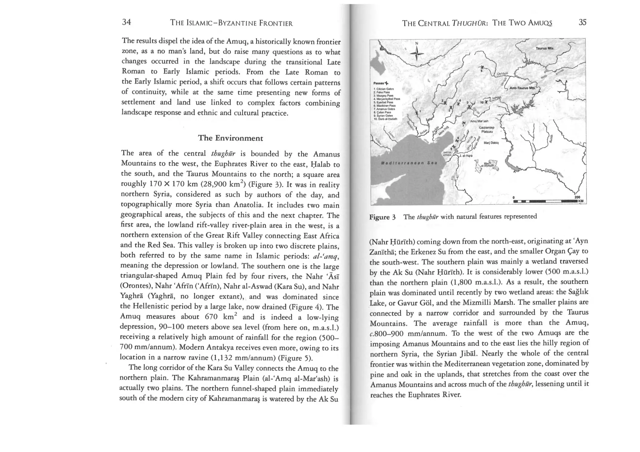
was the province of al-thughilr (Figure 1).
INTRODUCTION
7
8
9
THE ISLAMIC - BYZANTI NE FRONTIER
INTRODUCTION
The root of the term thaghr (plural thughur) can mean frontier,
mouth, or front teeth, likened to the towering Taurus Mountains
dividing Byzantine and Islamic lands. Thaghra (plural thaghar) can
mean a mountain pass, chink or crevice, and gap or breach in a wall
(thalma).20 A logical meaning of thughur in the frontier sense,
combining the ideas of gaps and teeth, would refer to the spaces
between the teeth, the river gorges that passed through the
mountains which linked Islamic and Byzantine lands and were
crucial for the movement of armies, nomadic groups, traders, and
religious pilgrims. Similarly, the Byzantines called these passes
stomata, or mouths. The landscape of the thughur was criss-crossed
with roads connecting settlements: large cities that had functioned as
important urban centers in the preceding centuries; towns and forts,
way stations, small villages, farms, and monasteries, inhabited by
Syriac-speaking Christians; and pastoral camps of Arab tribes, often
invisible in texts, who roamed the area before the arrival of Islam.
The frontier as a wilderness is not yet confirmed by the
archaeological evidence, supporting the fact that these events were
stories and topoi rather than eyewitness testimony. Excavations at
major frontier settlements such as Tarsus, Antakiya, and Sumaysat
show no dramatic destruction, ruin, or burning of these cities in the
seventh century. It must be remembered that much of the frontier, the
northernmost lands ofIslamic bilad al-sbsm, lies in a fertile agricultural
zone that receives ample annual rainfall. Surveys reveal newly founded
sites and irrigation systems. In Spain, the persistence of habitation of
seventh- and eighth-century sites with Roman or Gothic and Arab and
Berber toponyms belies any depopulation. The idea of an empry
frontier falls in line with an academic view that has been strongly
questioned and largely abandoned in the last 30 years, namely, the
decline of settlement after the Islamic conquests in the seventh century.
Although archaeological investigation would normally not expect
to perceive short-term depopulation followed by resettlement, the
type of absolute depopulation described in the texts is doubtful.
Deliberate destruction and the burning of forts would leave
archaeological traces, besides involving an excessive amount of labour
for a people in retreat. Furthermore, while many city-dwelling elites
and garrisons may have fled with the Islamic conquests, many other
people remained, particularly those peoples settled in rural areas,
many of which were isolated and monastic communities of
non-Chalcedonian Miaphysite and other Christian orders.i ' This is
also suggested by 'Iabari's mention of Heraklios depopulating only
the 'people of the fortresses', suggesting that non-military and nonofficial inhabitants remained. Survey evidence shows that Islamic
settlement was initially very limited and focused on administrative
urban areas and irrigated agricultural estates in the plains. Settlement
by Muslims would have been even more marginal on the edges of
Islamic territory. Arab tribes who practiced nomadic or seminomadic pastoralism and were either Christian or Muslim were also
part of the landscape, but often archaeologically invisible. While
initially reduced, an empty landscape of smoke and ruin did not exist
save in the perceptions of contemporaries.
Creating a concept of a mythic wilderness is a potent legitimizing
tool for a new rising power, and important to the construction of a
new ideological frontier. This concept functions as a process,
according to 1. Kopytoff, which begins with the creation of an
institutional vacuum: 'The definition of the frontier as "empty" is
political and made from the intruders' perspecrive.rv' Abandoned
buildings and burned lands can imply a time ripe for a new
beginning and, metaphorically speaking, new growth. Indeed, the
same themes of ruin and compulsion to rebuild using the civilizing
concept of 'imdra repeats in key moments of political maneouvering
on the Early Islamic frontier. Both the settlements of Adhana and
Massisa were described as ruined (and abandoned) until the 'Abbasids
arrived. Similarly, the Caliph al-Mahdi (r. 775-85) at the start of the
'Abbasid caliphare sent his Khurasani horsemen to Tarsus only to find
it in ruins, which he then ordered rebuilt. Not long after, Harun
al-Rashid (r. 786-809) did the same for Tarstis in 806-7. 23 These
narratives serve to deny an even earlier Islamic historical claim to the
settlements by the Umayyads.
Historians, archaeologists, and frontier scholars working on
parallel cases now generally accept that medieval frontiers were never
conceived as specific borders of demarcation between two entities in
10
THE
ISLAMIC-BYZANTINE FRONTIER
binary opposition, but rather were complex zones that were defined
both by their inhabitants and by their character as peripheral lands in
relation to their central ruling bodies, which fluctuated over time. 24
Further, frontiers are dynamic processes embodying the cultural
interactions taking place within these diverse societies, including
adaptation, acculturation, assimilation, and the cultural ambiguity of
ethnic and religious groups. In some cases these interactions created
new societies (erhnogenesis), uniquely born out of living within a
peripheral sense of place. Some archaeologists have argued that
contrary to the assumption that the central place typifies culrure, it is
precisely this interconnectedness of societies and visible process of
social change on the frontier that should draw attention to its cultural
importance. Taken even further, the processes of frontiers are not
rooted to a fixed periphery but are moveable, and even manifest
internally within settled societies.
Concepts of territory during the medieval period did not define
space and frontier as we do today. Geographers described their world
in terms of itineraries and traveling distances rather than
geographical space; political maps were later institutions. Territories
were demarcated physically, often by single points or boundary
markers. 25 Natural features, such as the Taurus Mountains, were also
used to delimit areas. This can be seen in the early maps of some of
the Muslim geographers such as MuqaddasI (b. 945) and IdrIsI
(d. 1165/6), which show abstracted lines for mountain ranges and
coasts. Cartographers abstracted space in conceptualized ways, showing
only the largest and most significant areas rather than depicting their
worlds comprehensively and accuracelyi" The articulation of rule was
over people rather than physical land. Similarly, forts were always
described by who controlled them, rather than as physical markers of
a frontier. 27 There were no political boundaries or unified agreements
on the thughur by geographers. Rather, 'frontier' was articulated as
the distance away from the capital or urban center, that is, the coreperiphery model. 28 This division of core and periphery, however, was
not universally fixed. The capital was only given prominence and
value through the ideologies and myths created by the ruler (or his
propagandists) as specific situations and challenges arose. 29
INTRODUCTION
11
Furthermore, the capital (via the caliph) moved to the frontier several
times throughout the Early Islamic period.
Several important studies on specific Roman, Byzantine, and
medieval frontiers around the Mediterranean have advanced the
conceptualization of territory significantly, and are useful as they
illustrate the complexity of frontiers. Roman frontiers, whose
infamous limes were once conceived of as strict boundaries, are now
regarded as interactive zones of commercial and cultural contact. 30
J. F. Drinkwater, based on the research of the fourth/fifth-century
Frankish border, states that the frontier was a 'stage show with
created threats to mask internal instability'. 31 Byzantine rulers
demonized the local 'barbarians' and actively employed aggressive
policies towards them in part for self-aggrandizement and to justify
keeping a military force on the frontier for internal security and tax
collection, thereby adding a layer of political and religious ideology.
Similarly, the landscape was appropriated symbolically in the
reoccupation of cities and other features. From an analysis of Islamic
frontiers, T. Rooke argues that part of the process of establishing
political sovereignty involved 'imposing new boundaries on the past
and/or old boundaries on the present [. ..} establish[ing} the stories of
events [and} interpreting aggressive attempts at regional hegemony
[...} as glorious defensive anti-colonial struggle,.32 Part of this
discourse involved establishing foreign invaders and occupants not only
as enemies and the 'other' but as a destructive force, for the purposes of
forging political unity. Taking this view further, D. Miller states:
Anthropologists have shown us clearly that the first
ethnographies of frontier native populations are always written
by imperial intruders who consistently interpret the pathological
militarized state of native society, which is the product of their
own intrusion, as the normal state of native society, subsequently
using the resultant stereotype of war-like 'barbarians' as a
justification, often after the fact, for aggression.33
Shrouding the frontier and enemy in religious and apocalyptic
rhetoric was one response to crisis, and it justified aggression. For the
12
THE ISLAMIC-BYZANTINE FRONTIER
INTRODUCTION
Byzantines, the seventh through ninth centuries were angst ridden;
lost borders were attributed to a difficulty in defining God's realm.
The other side of the frontier became part of a dichotomous good/evil
eschatological narrative of the post-apocalyptic rise of the heretical
nomadic steppe lands of Gog and Magog. 34
Subsequent aggressive policies and economic policing on the
part of the central state backlashed, eventually leading to social
competition and the rise of local charismatic leaders on the frontier
who were detrimental to the central state. 35 As the idea of the central
state disintegrated in the Middle and Late Islamic periods, so too
did the idea of a physical frontier. Rather, everyone was located
somewhere on the frontier and often those on the frontier had more in
common with each other than with the central state. As such, the
periphery was repositioned as the center and from it radiated spheres
of influence encompassing human frontiers of religious plurality,
ethnic diversity, and cultural prcduction.Y' The frontier became a
matter of perspective.
Byzantine and Islamic archaeology has, with a greater emphasis on
the latter, traditionally focused on only the most urban and religious
manifestations of the physical world. Amidst the urban network was
a thriving rural landscape of villages and multi-ethnic communities,
many of which were non-Muslim. Outside the villages and settled
communities were many nomadic tribes whose transhumant ways of
life often moved out of the range of the Empire. Beyond the Empire was
frontier. To understand the thughilr is to examine first and foremost its
rural settlements and land-use patterns, breaking the mould of an
uncultivated landscape dominated by a few forts. The textual bias
towards the urban elite and literate classes supplies mainly rich political
and religious information but prevents us from hearing potential voices
that are non-urban, and which live outside the framework of the
Empire. Newer consideration of Syriac sources provides more details of
towns, villages, and monasteries; the itineraries and routes taken; or the
ways of life and occupations of local inhabitants, albeit sometimes
coloured by religious convictions and hyperbole.V
Islamic archaeology in particular, as a form of historical
archaeology, emerged as a text-driven field, rooted in narratives and
using them as guides to search out the nature of this seemingly urban
culture and religion. For example, the material culture from the early
excavations of the 'Abbasid capital of Samarra', thought to be a shortlived settlement according to texts (836-83 or 892), was consequently
first dated to these years, which then served as a dating benchmark for
many other sites until recently. Newer research has expanded the scope
of urbanism, focusing on the urban landscape and the elements of
empire: cities and towns, mosques and other urban institutions,
primary centers of production, and intercity networks of trade and
economy. Though these projects have been less reliant on historical
documents, texts still serve as important supplemental and often
legitimizing tools for excavation. As a result, the belief that Islam was
an urbanizing civilization is constantly upheld by those who search for
it in cities and towns. Gradually, and very recently, studies of rural
settlement and material culture driven by social and economic
inquiries, often in relation to urban networks, are being considered that
can potentially examine new systems of locally organized culture.
The Great Divide
This book contributes to the conversations by researchers of frontier
studies, and reaches towards students and scholars in environmental
history. It also addresses both archaeologists and historians in the
fields of Byzantine and Islamic studies. This is no easy task. Despite
attempts in modern scholarship to mediate the two forms of
historical inquiry through an interdisciplinary approach; the fields of
Byzantine-Islamic archaeology and history continue to operate in
separate spheres, only occasionally utilizing, in uncritical and cursory
ways, information the other field has produced. Two challenges in
particular can be considered for this study: the physical landscape
and environment as a holistic object of study and the centuries of
transition as more precisely defined. In order to understand the
formation, nature, and process of the Islamic-Byzantine frontier and
test the textual model it is necessary to start from the ground up, we
need to first examine the archaeological evidence before reintroducing the textual evidence and configuring the two data sets.
13
14
lS
THE ISLAMIC-BYZANTINE FRONTIER
INTRODUCTION
Studies on the tural Byzantine and Islamic landscape have had
differing results and agendas. Often these remain as singularly
focused excavations arguing for an urban model of comparison by
patterns of physical resemblance or material culture production.
However, the rise of landscape archaeology and the study of the
settled environment mainly, through regional surveys and remote
sensing using aerial photography and satellite imagery, have, in the
past 20 years, significantly expanded our knowledge of rural agrarian
systems of settlement and land use, giving voice to the 'silent majority'.
Even more importantly, landscape archaeology is a diachronic method.
It allows us to glimpse the tongue dude history of humans and nature
symbiotically, affecting and reacting to one another in a constant yet
inseparable relationship.
Consideration of post-seventh-century periods in this field is still
quite nascent, but developing at a rapid pace. Irrigation and
agricultural innovations historically tied to Early Islamic-period
developments (the Green Revolution) are now largely disproved and
have been contextualized in a much longer history of agrarian
transmission. Ever more Near Eastern surveys, though not all, are
considering medieval settlement processes and their profound effect
on the environment, some of which will be examined closely in this
volumer'" Researchers in Spain have uncovered a rural network of
Early Islamic and post-reconquista multi-ethnic villages cenrered on
hydraulic features, using surveys, aerial photography, and linguistic
continuities rather than excavation. Archaeology in the thughilr
region is not entirely underdeveloped; it is possible to re-evaluate
what has already occurred with an eye toward the Early Islamic
period, configured by newer survey evidence.
A common yet distinctive pattern revealed in the periods of the
Late Hellenistic through Islamic was a key shift in settlement,
termed 'the Great Dispersal', from nucleated city states on tells of the
third and second millennium BCE and earlier to scattered villages and
farms throughout the Iandscape.Y Settlement steadily increased, the
peak in most areas occurring in the fifth and sixth centuries with an
explosion of sites everywhere. Sites tended to be diffuse and very
small (less than 1 ha) with no topographic relief, only distinguishable
by scatters of pottery, roof tiles, and building stones. Surveys that
prioritized the recording of tells produced skewed settlement patterns
for the first millennium CE. Furthermore, not every landscape was
equally preserved. Settlements in arid and rnontane landscapes, such as
the infamous Syrian Jibal (apparent by its better-known name of the
Dead Cities), represented a rare landscape of survival based mainly on
the durability of stone as a construction material and the fact that their
upland location was unaffected by flooding and sedimentation. In the
low plains of the thughilr, most of which were seasonal or permanent
wet1ands, settlements were built of local materials, such as mud brick
and reeds. This distinction has created an archaeological bias towards
finding sites whose remains are visible, large, or striking, while elusive
settlements built of perishable materials in more biodegradable
40
surroundings have been overlooked.
A noticeable lacuna in both the Near East and Spain is the
existence of the nomad or serni-pastoralist, particularly given the
strong association with the initial spread of Islam through Arab
tribes. This is no trivial omission; pastoral groups represent an
unquantified but substantial segment of the population (Figure 2,
p. 24).41 On the thughilr, these populations would have occupied the
seemingly inhospitable wilderness regions of marshes and mountains.
Their interaction with settled societies and competition over land
and resources was at the heart of virtually every conflict, imagined or
otherwise. In certain periods, pastoral groups may have outnumbered
settled groups. In the archaeological record, these moments show
periods of decline. For example, once the fifth-century landscape was
universally accepted by scholars as a high point for settlement and
population, the point of change was marked by the middle of the
seventh-century period with the spread of the mainly pastoralist
Muslim tribes. The question of seventh-century decline after the
conquests is linked to the visibility of these earliest settlements, and a
finer focus on periodization is still necessary.
The issue of chronology, crucial to both historians and
archaeologists, is a second challenge, particularly for the elusive
transition from the Late Roman (fourth to mid-seventh centuries) to
the Early Islamic period (mid-seventh to mid-tenth centuries;
16
17
THE ISLAMiC-BYZANTINE FRONTIER
INTRODUCTION
640s to 960s for the frontier).42 Typically, discrepancies 10
chronology are exacerbated by the disciplinary divide between
archaeology and history; the first two centuries of Islamic rule, where
texts are few, are best informed by archaeological evidence, albeit
broadly dated, and the subsequent centuries by textual evidence,
which is often retrospective, elitist, and government approved.
Transformation in the seventh century occurred unevenly, with
political changes manifesting as the quickest and most visible,
followed by economic reorientation, and finally the cultural (and
material culrural) milieu evincing the most gradual response. It
follows that settlement patterns and environmental change would
also not be readily or quickly apparent. The invisibility of the seventh
century has been typically interpreted as a period of decline, the end
of the Classical world. Tbugbar text-based srudies have tended to omit
this century and the period that followed entirely, and to focus rather
on the Roman to Late Roman limes or Middle Byzantine reconquest of
the tenth century through the Crusades. From landscape surveys, Late
Roman and/or Early Islamic decline is partly determined via
interpretation of lack of identifying ceramic diagnostics, particularly
since Roman terra sigillat«, Late Roman finewares (mostly ending in
the mid-seventh century), and Islamic glazed wares (mid-eighth
century/early ninth century and beyond) are easily spotted on walking
surveys, are easily dated, and dominate assemblages. Mid-seventh to
mid-eighth-century/ninth-century ceramics are often harder to
identify, and accordingly suggest a drop or gap in settlement in the
first cenrury of Islamic occupation. As a result, survey ceramic
analyses, often done without a specialist on board, have swung toward
the cautious, often identifying 'late period sites' as dating from the
Roman to Early Islamic, or the first century BCE to tenth cenrury CE.
Three decades of scholarship by Islamic archaeologists have
resoundingly discarded the notion of seventh-century decline,
recognizing the archaeological, and in some cases economic,
continuity from the Late Roman to Early Islamic Near East. 43 For
some archaeologists, the notion of decline was not dispensed with
entirely but simply pushed further to the 'Abbasid period, or back
to the early sixth-century Persian conquests. This was based on an
over-reliance on misdated coins and ceramics and the wish to align
historical-political timelines with material culture. In the
archaeological context, Late Roman to Early Islamic continuiry has
in recent times created a redefined transitional period encompassing
the sixth to eighth centuries.
This macroscopic view of continuity, however, highlights two
important factors of settlement patterns: 1) that there was never a
period of total abandonment in the Early Islamic period; and 2) that
sites with Late Hellenistic/Early Roman to Early Islamic occupation
are often a part of a different system of settlement patterns than preRoman or post-Early Islamic occupied sites. While this transition
correctly identifies the difficulty in assigning ceramic typologies to
political changes, such a fluid categorization limits the srudy of the
last cenruries of Byzantium, the beginnings of Early Islam, and the
identification of its initial settlement. At a very general level,
absolure continuity between the Classical and Islamic periods is not
tenable; change carried political, religious, and cultural implications
and occurred on every level, from material culture to rural sites and
urban cities to trade networks and land-use projects. With regard
to the Islamic-Byzantine frontier, its formation and choices for
settlement have become blurred in favour of a general continuity. In
this way, the challenges of transition and landscape archaeology, with
its reliance on surface ceramics, are intertwined.
Can a landscape-archaeology approach detect socio-political and
religious differentiations, or is this perspective perhaps too coarsely
grained to pick up such subtlety? This question becomes
particularly salient in border zones or frontiers and time periods
that have been determined to be transitional. The task of correlating
political/cultural periods to archaeological and geomorphological
time seems an oversimplification of two very different data sets.
However, I would argue that the opposite is true. The process of
transformation occurred over an important benchmark in the Near
East - that is, the Islamic conquest. As such, it is essential to combine
archaeological and historical methods to take advantage of this cultural
shift and reveal the new populations, communities, settlements, and
material cultures that were introduced or developed as a response to
18
19
THE ISLAMIC-BYZANTINE FRONTIER
INTRODUCTION
cultural mixing. When this cultural shift is overlaid on a profoundly
transformed landscape, it allows for a greater distinction to be made
between the Late Roman and Early Islamic periods. Such a combined
study can inform whether settlement and land use was linked more
with cultural and ethnic practices or evolved naturally as a response by
any culture to the changing landscape.
and two have been intensively mapped and surveyed CAyn Zarba and
possibly Hantniyya) in the past 20 years (and mainly in the past ten
years). At present, the results do not give us an idea of these towns as
fortified garrisons; however, future work may alter our understanding. Textual analysis of the usage of military or non-military
terminology in relation to these towns, while not a part of this study,
should be undertaken in the future as it may add a further dimension
in tandem with the archaeology to how these towns were perceived.
This study will examine frontier towns as one of a number of
settlement types and discuss their geographic location, chronology,
and economic viability as part of the larger frontier landscape.f"
Although textual references at times suggest a division of the
frontier into a more vulnerable front-line zone (thughilr) and rear-line
('awilfim) province, reputedly for defence and supply, these divisions
only occur from the end of the eighth century and the frontier did not
remain static but developed over time. Shaban first commented that
the creation of the 'awa,sim was intended to produce a more tightly
controlled and closer defence system, and primarily to curb
investment in the upkeep and garrisoning of more exposed thughilr
towns. Bonner argues that this division was an idealized and political
administrative move to enable the 'Abbasids to assert authority over
47
former Umayyad lands and prevent the growth oflocal power. Abu
Ezzah argues that this division was arbitrary and flexible, and that the
list of 'awa,sim towns changed from author to author. In reality this
designation did little to affect the everyday life or fate of frontier
settlernents.Y The limit of the short-lived first frontier was at the
provinces of Hims (Ernesa) and Qinnasrin (Chalcis). These and other
towns gradually became subsumed as the Islamic conquests expanded
northwards to the Taurus Mountains and beyond. Eventually, the
Taurus demarcated a rough upper limit of settlement for the thughilr.
In an archaeological study of frontier landscapes, however, the
frontier should be divided first by its natural topography, then by its
settlements, and consideration given to all parts of the frontier and
beyond. While seemingly similarly arbitrary, this division is
grounded in historical perspectives and serves two purposes. In the
medieval world, with regards to maps and boundaries, spaces were
Layering the thughur
It is hoped that this volume will provide alternative routes,
contributing toward a re-articulation of the Islamic landscape that
synthesizes original survey and excavation work and other published
and unpublished archaeological evidence. The focus is on the Early
Islamic period, but patterns and changes in the landscape are traced over
a millennium from the Late Roman through to the Middle Islamic!
Byzantine periods, the fourth to fourteenth centuries. Furthermore, this
study will examine the points of congruity or incongruity between the
archaeologyof the frontier and its text-based narratives. This study does
not begin with the assumption that parts of the frontier were more
militarized than others, whether through the perception of a religious
battleground, the presence of fortified garrison towns, or a strategic
division of the region. The spiritual landscape or conceptual frontiers of
the Islamic Empire will not be addressed here, but recent studies have
admirably shown how these spaces can be seen as ways of imagining
imperial control, articulating dominion, controlling the greater world,
discrediting parts of it, and claiming others.44
As already discussed, either as a line or defence-in-depth zone,
fortified garrison towns are implied from textual sources. Caliphs
established camps, fortified them with walls, and garrisoned them,
leading some to argue that they followed a similar pattern to the
am!ar, newly-founded garrison towns throughout Islamic territory
established in the seventh century.45 However, as nearly all of these
thughilr towns were Byzantine cities and none have been excavated,
there is no archaeological evidence to suggest how they were planned
and whether they functioned primarily as garrison towns. Only two
of these settlements have been excavated (Tarsus and Hisn al-Tlnat),
20
21
THE ISLAMIC-BYZANTINE FRONTIER
INTRODUCTION
conceived in relation to natural features and chief cities that ruled
districts. Further, by drawing attention to the environmental features
of the frontier we can closely examine in a Braudelian fashion patterns
of settlement and subsistence that cut across textually informed
ideological constructions of the frontier.
This book will ultimately argue that the frontier, both real and
imagined, is a framework where processes of interaction and exchange
took place between communities. The argument will build slowly
in two analytical sections. Part 1 (Chapters 1 to 5) provide
chronologically grounded archaeological evidence for the environment from geomorphology, natural resources and products, and
routes. Following this, survey and excavation data examine the
several specific categories of settlement and land-use activities
throughout the entire thughur, including northern Syria and
Mesopotamia. The model of analysis used for all the data, often
statistical and technical in nature, is derived from surveys of the two
large plains: the Amuq Plain of Anrakiya in al-'awas,im and the
Kahramanmaras Plain of Mar'ash, the forward post of Antakiya in
al-thughur. Data for the elusive Late Roman to Early Islamic periods
will be gleaned from recent high-resolution surveys and older low
resolution surveys from both the thughur and 'awiis,im regions,
reassessed to produce a clear image of settlement patterns during this
time. The ]azIra river valleys of the Balikh and Khabur, not formally
part of the frontier, are analyzed as a comparative or counterpoint to
the rest of the frontier. A central question will be to what extent these
various regions, such as the Amuq (part of al-'awaJim) and the ]azIra,
displayed similarities in the settlement and land-use characteristic
of a larger frontier province, showed differences supporting textual
reference to administrative provincial jurisdictions, or diverged into a
topographically-based set of contiguous river valleys and plains each
with their own micro-regional patterns. Results will show that for
most of the frontier, with the exception of the region around Halab
and most of the ]azlra, Early Islamic sites were reduced by half from
the Late Roman period. More specifically, seventh- to eighth-century
sites were fairly few, although they included new foundations, while
eighth- to tenth-century sites were more numerous. This is not
evidence of a 'no man's land' on the frontier nor of a continuously
inhabited landscape, but rather of one that underwent a substantial
reduction of population but became the focus of settlement and
economic development.
Part 2 synthesizes settlement patterns, land use, and social
interactions in their environmental and historical contexts. Historical
evidence from primary texts including geographies written mainly in
Arabic; Islamic histories; Byzantine military treatises; and, most
importantly from a rural perspective, Greek and Syriac saints' lives
all provide contextual frameworks and at times explanations for
the patterns of settlement and land use. Chapters 6 to 9 present a
narrative of settlement that incorporates wider Anarolian survey
evidence and the Islamic-Christian thughur of al-Andalus. While the
primary locus of discussion is the Early Islamic period, the narrative
can be extended to trace change from the Late Roman to the Early
Islamic and the Early to Middle Islamic transitions and periods of
occupation (or lack thereof).49 The development of agricultural estates
and irrigation, networks of way stations, adaptations to the spread of
marshlands, and the eventual rise of villages and fortified castles are
keyed into historical narrative. Chapter 10 closely examines the nature
of different types of social interaction and exchange on the thughur,
besides those stemming from jihad and apocalyptic ideologies,
such as trade and market economy, fluctuating tribal identities,
and the rhythms and movements of pastoral populations. I argue that
the frontier was layered and constituted three types of interactions:
external (competition for resources between groups), internal
(political relationships between the central state and peripheral
groups), and ideological (military and religious conflict). Movement
and communication across frontier spaces consisted primarily of
upland and lowland interactions that were not limited to a singular
monumental frontier. Instead, these are duplicated across time over
localized environmental frontiers constituting ecological 'niches' of
liminal space. This volume contributes to a more complex vision of
the frontier than traditional historical views by juxtaposing layers
of a real ecological frontier of settlement and interaction with an
imagined military/religious ideological frontier.
PART 1
THE SYRO-ANATOLIAN
THUGHUR
Throughout the history of the thught7r, Islamic authors frequently
refer to two geographical divisions on the frontier: the Syrian west
(thughilr al-shamfya) and the Jazlran east (thughur al-jazarfya), with
the Amanus Mountains and town of Mar'ash as the fulcrum. These
divisions are not so much geographical (typically, all lands west of the
Euphrates are part of Bilad al-Sham) as military, referring to the
backgrounds of the soldiers on the fronter and a two-pronged doubleflank style of summer raids from the left and right (al-!a'ija al-yusrs,
al-!a'ija al-yumna) to the Byzantine frontier. Further, they are
mentioned by some geographers, such as Istakhri and Ibn Hawqal,
but not others, such as Muqqadasi.' Topographically, the frontier can
be divided into three large areas, each with smaller micro-regions
that are bounded by natural geographic features (Figure 3, p. 35). The
western frontier, or Cilician Plain, stretches from Rough Cilicia to
the Amanus Mountains. The central frontier (from the Amanus to the
Euphrates River) can be subdivided into two areas: the western rift
valley of the Amuq and Kahramanmaras Plains and the eastern hilly
steppe and plain of the Nahr Quwayq and jabbul Lake. The eastern
frontier (east of the Euphrates, including the Upper Euphrates to the
Tigris River) includes the Karababa, Malatiya, and Elazlg (Keban)
Plains to the north. In presenting them, we can follow a central to
east to west schematic, tracing roughly the path of interest taken by
24
THE ISLAMlC-BYZANTINEFRONTIER
THE SYRO-ANATOLIAN THUGHUR
25
Methodology
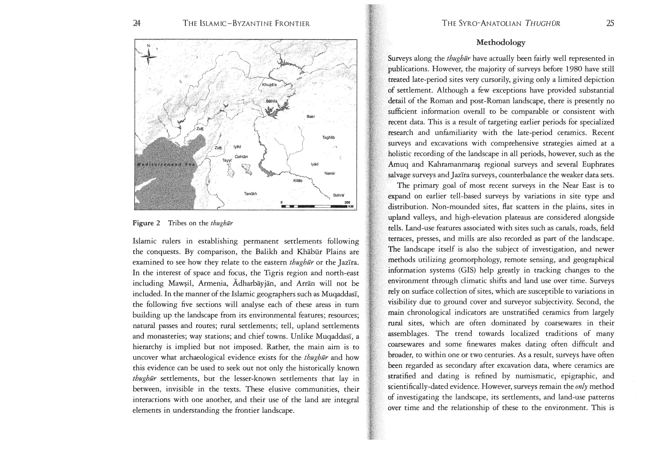
Figure 2
Tribes on the thttghiir
Islamic rulers in establishing permanent settlements following
the conquests. By comparison, the Balikh and Khabur Plains are
examined to see how they relate to the eastern thughilr or the J azira.
In the interest of space and focus, the Tigris region and north-east
including Mawsil, Armenia, Adharbayjan, and Arran will not be
included. In the manner of the Islamic geographers such as Muqaddasi,
the following five sections will analyse each of these areas in turn
building up the landscape from its environmental features; resources;
natural passes and routes; rural settlements; tell, upland settlements
and monasteries; way stations; and chief towns. Unlike Muqaddasi, a
hierarchy is implied but not imposed. Rather, the main aim is to
uncover what archaeological evidence exists for the thughur and how
this evidence can be used to seek out not only the historically known
thughilr settlements, but the lesser-known settlements that lay in
between, invisible in the texts. These elusive communities, their
interactions with one another, and their use of the land are integral
elements in understanding the frontier landscape.
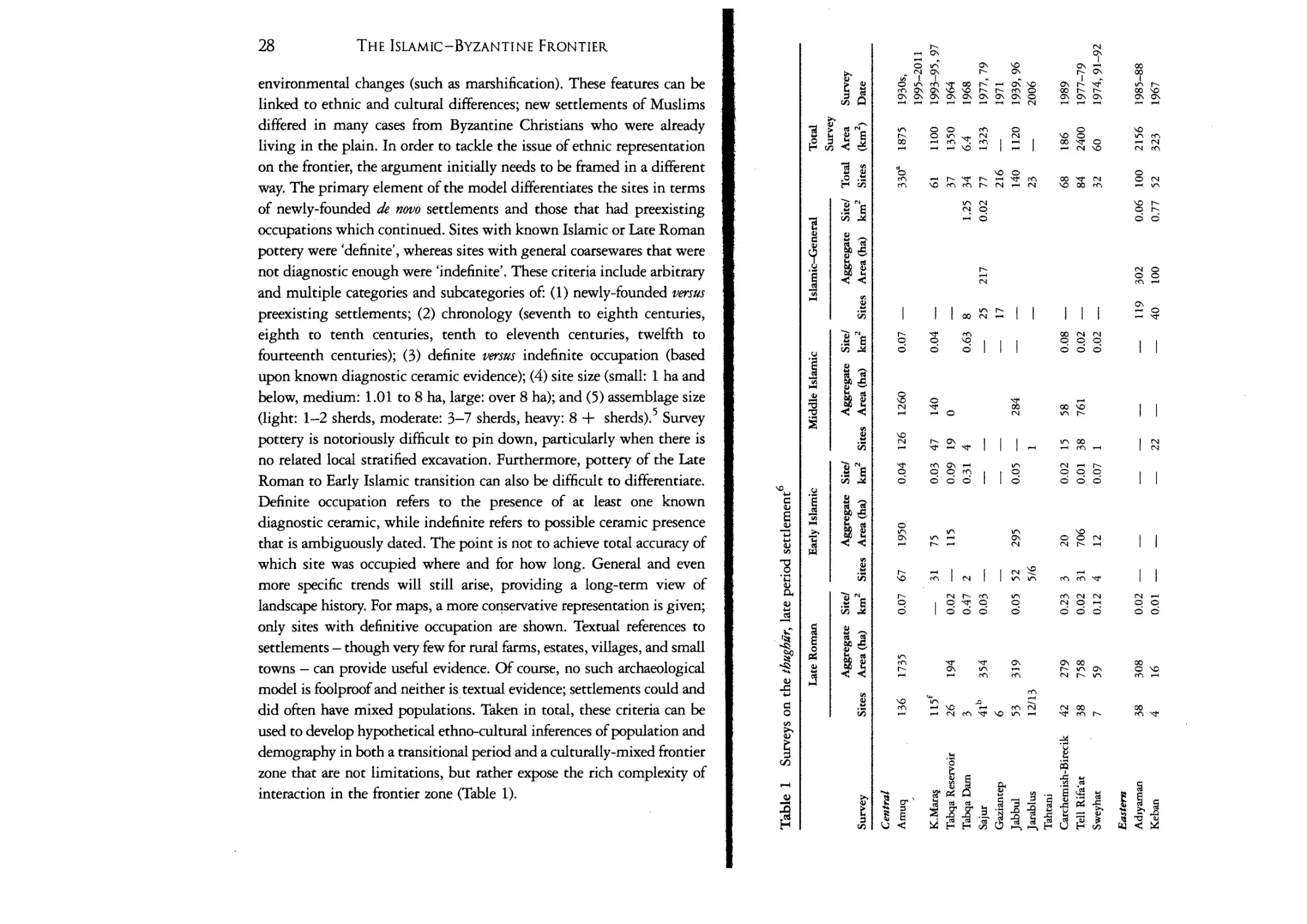
along the thughur have actually been fairly well represented in
pUIJIH:atJlOns. However, the majority of surveys before 1980 have still
late-period sites very cursorily, giving only a limited depiction
settlement. Although a few exceptions have provided substantial
of the Roman and post-Roman landscape, there is presently no
information overall to be comparable or consistent with
data. This is a result of targeting earlier periods for specialized
and unfamiliarity with the late-period ceramics. Recent
and excavations with comprehensive strategies aimed at a
recording of the landscape in all periods, however, such as the
and Kahramanrnaras regional surveys and several Euphrates
surveys and Jazlra surveys, counterbalance the weaker data sets.
The primary goal of most recent surveys in the Near East is to
on earlier tell-based surveys by variations in site type and
distribution. Non-rnounded sites, flat scatters in the plains, sites in
valleys, and high-elevation plateaus are considered alongside
Land-use features associated with sites such as canals, roads, field
f,,\;.lU1LI;;<>, presses, and mills are also recorded as part of the landscape.
landscape itself is also the subject of investigation, and newer
rnetnoos utilizing geomorphology, remote sensing, and geographical
mrorrnation systems (GIS) help greatly in tracking changes to the
vU.un,.al. through climatic shifts and land use over time. Surveys
on surface collection of sites, which are susceptible to variations in
due to ground cover and surveyor subjectivity. Second, the
chronological indicators are unstratified ceramics from largely
sites, which are often dominated by coarsewares in their
The trend towards localized traditions of many
and some finewares
dating often difficult and
broader, to within one or two centuries. As a result, surveys have often
regarded as secondary after excavation data, where ceramics are
and dating is refined by numismatic, epigraphic, and
scientincallv-dated evidence. However, surveys remain the only method
investigating the landscape, its settlements, and land-use patterns
over time and the relationship of these to the environment. This is
26
27
THE ISLAMIC-BYZANTINE FRONTIER
THE SYRO-ANATOLIAN THUGHUR
particularly the casefor the Islamic-Byzantine frontier, for which there
have been around 35 surveys and only a handful of excavationsof sixthto tenth-century sites.
Not all of these surveys can be taken at face value or compared
with one another as their methods differ radically, their results are
inconsistent, and their treatment of the Islamic period is general at
best. Meaningful comparison and reinterpretation is required, and it
reveals pertinent general information that should not discarded
outright as it supports the evidence from higher-resolution Islamicfocused surveys. As a result, surveys can be divided into four main
groups: (1) extensive and coarse low-resolution large-area surveys; (2)
intensive and high-resolution large-area surveys; (3) extensive and fine
high-resolution large-area surveys; and (4) intensive high-resolution
small-area surveys around sites and with reliable dating for the Islamic
periods. Surveys ranged in methodologies, and, as a result, intensive or
extensive classifications are on a scale: intensive surveys typically
employed walking transects and off-site investigation while extensive
surveys also used vehicles and were tell-focused.2 Low-resolution and
high-resolution refers specifically to the reliability of dated ceramics
from the Islamic period that employ subdivisions. The coarse lowresolution surveys of the first group will be briefly described along
with their general observations. The second and third groups will be
analysed more comprehensively, taking into consideration the strong
caveat that these high-resolution surveys had more finely tuned Islamic
chronologies that allow subdivision. Recent excavations and a greater
understanding of transitional and Early Islamic ceramics also permit
more accurate dating of sites previously categorized by very general (at
best) or incorrect chronologies. Even while this book is being written,
new surveys and excavations are being conducted. Salvage excavations
of rural and urban sites around the frontier carried out by Turkish
museums add a significant level of information that unfortunately
cannot be included in this study, as most of these are never published.
Future work should add them to the larger data set. Using mainly
survey data with some supplemental excavation evidence when
available, these areas will be examined from an Early Islamic
perspective that considers more broadly what came before and after. As
labels and periods differ from survey to survey, it is necessary to
configure the evidence into accepted chronologies while the original
period designations will be parenthetically mentioned.
Certain trends can be detected that show general and specific Early
Islamic frontier settlement patterns that are present throughout the
frontier, and, at the same time, variations in rnicro-regions.f Some
analysis tools that have been used for other surveys with good results,
such as calculating sites per square kilometer, aggregate site area per
period, and site catchment areas, will not be systematically used here.
Many of these surveys are not comparable on these levels. For example,
the Amuq was surveyed for more than 15 years. More than 300 sites
were found in an area of almost 2,000 km'', while the Nahr Quwayq
was surveyed for two years in which 80 sites were found in an area of
nearly 2,500 km 2 • Many more sites are clearly visible with remote
sensing techniques. Within these areas, one survey focused on uplands
as well as lowlands while the other did not. Site area calculation also
represents a challenge. Many older surveys did not note site areas;
however, it is possible to calculate them with the help of satellite
imagery or aerial photography. Such a huge undertaking is beyond the
scope of this book, but is currently being conducted in the region."
Figuring out chronologies from such surveys still poses a problem. As
such, comparing site signatures and numbers remain useful for this
study. The main reason for this is that we are investigating relatively
short-term changes in the landscape around settlements from the
fourth to fourteenth centuries, how they are occupied, whether they
continue, and, if not, when they are abandoned.
Yet, for the Islamic-Byzantine frontier, how can we refine the data
futher and determine settlement patterns during the entangled,
transitional sixth to eighth centuries? Or make claims as to which
settlements were Islamic and which Christian? In approaching these
questions, a model is applied to the Amuq and Kahrarnanmaras surveys
that views sites with certain criteria leaving room for nuance and
degree, rather than labelling sites statically as transitional (Late Roman
to Early Islamic), or one or the other (Late Roman or Early Islamic).
There are discerning factors in settlement choicesfrom the Late Roman
to the Early Islamic periods resulting from human responses to
28
THE ISLAMIC-BYZANTINE FRONTIER
environmental changes (such as marshification). These features can be
linked to ethnic and cultural differences; new settlements of Muslims
differed in many cases from Byzantine Christians who were already
living in the plain. In order to tackle the issue of ethnic representation
on the frontier, the argument initially needs to be framed in a different
way. The primary element of the model differentiates the sites in terms
of newly-founded de novo settlements and those that had preexisting
occupations which continued. Sites with known Islamic or Late Roman
pottery were 'definite', whereas sites with general coarsewares that were
not diagnostic enough were 'indefinite'. These criteria include arbitrary
and multiple categories and subcategories of: (1) newly-founded versus
preexisting settlements; (2) chronology (seventh to eighth centuries,
eighth to tenth centuries, tenth to eleventh centuries, twelfth to
fourteenth centuries); (3) definite versus indefinite occupation (based
upon known diagnostic ceramic evidence); (4) site size (small: 1 ha and
below, medium: 1.01 to 8 ha, large: over 8 ha); and (5) assemblage size
(light: 1-2 sherds, moderate: 3-7 sherds, heavy: 8 + sherdsj.? Survey
pottery is notoriously difficult to pin down, particularly when there is
no related local stratified excavation. Furthermore, pottery of the Late
Roman to Early Islamic transition can also be difficult to differentiate.
Definite occupation refers to the presence of at least one known
diagnostic ceramic, while indefinite refers to possible ceramic presence
that is ambiguously dated. The point is not to achieve total accuracy of
which site was occupied where and for how long. General and even
more specific trends will still arise, providing a long-term view of
landscape history. For maps, a more conservative representation is given;
only sites with definitive occupation are shown. Textual references to
settlements - though very few for rural farms, estates, villages, and small
towns - can provide useful evidence. Of course, no such archaeological
model is foolproof and neither is textual evidence; settlements could and
did often have mixed populations. Taken in total, these criteria can be
used to develop hypothetical ethno-cultural inferences of population and
demography in both a transitional period and a culturally-mixed frontier
zone that are not limitations, but rather expose the rich complexity of
interaction in the frontier zone (Table 1).
v-,
N
NO
~
cl
N 0
00
'"
I I I
r-
'" I I
~
o
o
~
N
.....
.CIJ~
~
.....
0-
..... 0
.....
I I
0
N
.....
N
N
N
.....
r-
000
000
ov-,
""
I I
'0
0.....
.....
""
v-,
~
I
v-,
.....
r- .....
'0
0-
00
N
N
N
NOf'
I I ""
""
o
o
v-,
I I
N
r- .....
N
.....
00
00
00
0'0
.....
'"
"" .....
'"
N
'"
.....
Table 1 (contintted)
Late Roman
Early Islamic
Middle Islamic
Islamic-General
Total
Survey
Aggregate Site!
Aggregate Site!
Aggregate Site!
Aggregate Site! Total Area
Survey
2
2
Area (ha) km Sites Area (ha) km Sites Area (ha) km 2 Sites Area (ha)
km 2 Sites (km 2)
Date
Survey
Sites
Kurban
Hoyuk
Gritille
Tirri§ Hoyuk
Lidar Hoyuk
Bozova-Urfa
18
58
0.02 5
22
0.01 8
33
0.01
-
25
1000
1980-84
17
42
97
89
83
0.40
0.19
0.19
0.02
7
0
50
42
0.05 7
4
0.07 0.01 -
21
22
-
0.16 0.02 -
19
30
29
21
43
177
150
800
1982--84
1991
1978--80
46
13
4
390
39
0.01 20
3
0.62 1
298
33
0.00 39
8
0.15 1
177
23
0.01 -
145
25
6
7585
1268
6.5
1951
1991
2005
103b
34<
797
1758
0.05 0.00 -
-
-
-
-
0.09 206
38
2000
16245
1989
1954-55
53
29
41
13
894
336
153
49
0.02
0.01
0.09
0.03
-
-
14
51d
8
-
0.97 97
0.00 55
96
69
2300
4770
475
450
1976-66,9
1989
1986-90
1997-98
33
28
13f
2
0
11
10
-
197~80
~stern
Cilicia (BIA)
Cilicia (Bilkenr)
Kinkkopru
}azira
Harran
Khabiir (Van Liere
and Lauffray)
E. Khabur
U. Khabiir
Norrh ]azira
Tell Beydar
785
63
-
-
0.11 28
0.02 2
-
0.15 -
-
-
398
3
94
15
0.06 0.00 -
-
175
-
-
1202
1426
252
-
-
Table 1 (continued)
Late Roman
Survey
Sites
Tell Hamoukar
Tell Leilan
Tell Beak
Balikh
Middle Euphrares
4
22<
23
18
Early Islamic
Aggregate Site!
Area (ha) km2
Total
Survey
Aggregate Site!
Aggregate Site!
Aggregate Site! Total Area
Survey
Sites Area (ha) km2 Sites Area (ha) km2 Sites Area (ha) km2 Sites (km 2 )
Date
131
-
0.03 30d
17
98
173
0.01 55
0.01 73d
292
388
-
Middle Islamic
0.18 9
0.01 41
189
966
391
550
0.03 12
0.06 68e
91
408
0.07
0.02
0.01
0.05
Islamic-General
-
-
-
-
-
-
146
26
35
56
65
111
125
2040
170
2074
1300
1999
1995
1978
1983
1987-90
These numbers cannot be taken as firm dates in every case, depending on the quality of each survey. Indefinite sites are not included, although sites
with 'light' ceramic assemblages are. Please refer to the text for each of these surveys for comments on methodology. Aggregate areas are inexact as
they reflect the total area of the site as delineated from CORONA satellite imagery and GIS. While most sites were traced, not all were found or are
preserved. Further, this number should be taken as an estimate as it is impossible, without excavations, to know how much of the site was occupied in
any given period.
"Includes only sites until 2004. Sites from 2005-11 have not yet been published.
b Roman and Late Roman are undifferentiated.
<Roman through Islamic are undifferentiated.
dIncludes a total of transitional seventh-century, Umayyad, and 'Abbasid periods.
"Includes several subdivided periods between the late tenth to fourteenth centuries.
CHAPTER 1
THE CENTRAL THUGHUR:
THE TWO AMUCli
You will depart and alightat a meadow with ruins (marj dhi tulul), 1
The above quote is taken from Early Islamic eschatological texts,
describing the Amuq Plain, or Plain of Antioch, as a frontier
battleground for one of the final apocalyptic wars. It was also a
battleground for the early conquests where Arab armies camped
on al-'Amq, the large fertile Plain of Antioch or Amuq, and chased
the fleeing Byzantines. It also, however, succinctly frames how
archaeologists have traditionally regarded the Amuq Plain and other
similar geographic regions all over the Near East, which are dotted
with tells Vulul) mainly of the fourth to second millennia BCE.
Indirectly, it alludes to the historical view of the frontier landscape
during and following the Islamic conquests as uninhabited. Recently,
close attention has been given to the non-tell landscape of the
Classical, Late Antique, and medieval periods. Surveys in the Amuq
and Kahramanmaras Plains revealed a crucial series of dramatic
changes that occurred in a relatively short period of time between the
Late Hellenistic and Early Islamic periods. In the Late Hellenistic
and Early Roman periods there was a rise in dispersed, low, mounded
or flat settlements in both lowlands and uplands, and an increase in
cultivation. By the Late Roman and Early Islamic periods, the
seasonal wetlands had expanded into a permanent lake and marsh.
34
THE CENTRAL THUGHOR: THE Two AMu~
THE ISLAMIC-BYZANTINE FRONTIER
The results dispel the idea of the Amuq, a historically known frontier
zone, as a no man 's land, but do raise many questions as to what
changes occurred in the landscape during the transitional Late
Roman to Early Islamic periods. From the Late Roman to
the Early Islamic period, a shift occurs that follows certain patterns
of continuity, while at the same time presenting new forms of
settlement and land use linked to complex factors combining
landscape response and ethnic and cultural practice.
35
P• • • es"\\'
1. ClIlclan Gat ..
2.Feke Pasl
3. Mazge'l;Pass
4. Meryerncri1belPass
5. Eyerbel Pass
6 . Mazlkira n Pass
7. AmanusG atel
B.c; alan Pass
9. Syrian Gale !.
10. Darb al-l:Iadalh
The Environment
The area of the central thughur is bounded by the Amanus
Mountains to the west, the Euphrates River to the east Halab to
the south, and the Taurus Mountains to the north; a square area
roughly 170 X 170 km (28,900 km' ) (Figure 3). It was in reality
northern Syria, considered as such by authors of the day, and
topographically more Syria than Anatolia. It includes two main
geographical areas, the subjects of this and the next chapter. The
first area, the lowland rift-valley river-plain area in the west, is a
northern extension of the Great Rift Valley connecting East Africa
and the Red Sea. This valley is broken up into two discrete plains,
both referred to by the same name in Islamic periods: al- lamq,
m:aning the depression or lowland. The southern one is the large
triangular-shaped Amuq Plain fed by four rivers, the Nahr 'AsI
(Orontes), Nahr 'AfrIn ('AfrIn), Nahr al-Aswad (Kara Su), and Nahr
Yaghra (Yaghra, no longer extant), and was dominated since
the Hellenistic period by a large lake, now drained (Figure 4). The
Amuq measures about 670 km 2 and is indeed a low-lying
depression, 90-100 meters above sea level (from here on, m.a.s.l.)
receiving a relatively high amount of rainfall for the region (500700 mm/annum). Modern Antakya receives even more, owing to its
location in a narrow ravine (1,132 mm/annum) (Figure 5).
The long corridor of the Kara Su Valley connects the Amuq to the
northern plain. The Kahrarnanrnaras Plain (al-'Amq al-Mar'ash) is
actually two plains. The northern funnel-shaped plain immediately
south of the modern city of Kahrarnanrnaras is watered by the Ak Su
.-
o
Figure 3
The thught7r with natural features represented
(Nahr Hurith) coming down from the north-east, originating at 'Ayn
Zanitha; the Erkenez Su from the east, and the smaller Organ Cay to
the south-west. The southern plain was mainly a wetland traversed
by the Ak Su (Nahr Hurlth). It is considerably lower (500 m .a.s.l.)
than the northern plain (1,800 m.a.s.l.). As a result, the southern
plain was dominated until recently by two wetland areas: the Saghk
Lake, or Gavur Gol, and the Mizmilli Marsh. The smaller plains are
connected by a narrow corridor and surrounded by the Taurus
Mountains. The average rainfall is more than the Amuq,
c.800-900 mm/annum. To the west of the two Amuqs are the
imposing Amanus Mountains and to the east lies the hilly region of
northern Syria, the Syrian j ibal. Nearly the whole of the central
frontier was within the Mediterranean vegetation zone, dominated by
pine and oak in the uplands, that stretches from the coast over the
Amanus Mountains and across much of the thughur, lessening until it
reaches the Euphrates River.
36
THE CENTRAL THUGHUR: THE Two AMU~
THE ISLAMIC-BYZANTINE FRONTIER
37
N
+
Figure 4
The Central thttghur
An important process induced mainly by human factors that took
place in the sixth to eighth centuries was marshification, the growth
and spread of marsh. The two Amuqs were always susceptible to
water-logging, and marshes had occurred in earlier periods. However,
the spread and then collapse of the "intensive upland cultivation,
mining, and deforestation seen in the growth and spread of Seleucidl
Hellenistic to Late Roman sites on the slopes contributed to an
erosion-prone landscape. Similarly on the plain, extensive irrigation
and canal building during these same periods followed by .
abandonment of maintenance procedures contributed to the creation
of a precarious and unbalanced ecological system. Abandonment of
upland settlements and terraces also destabilized the topsoil. Natural
processes such as more humid climatic conditions, greater
precipitation, more frequent storms, and occasional seismic activity
Figure 5
The Amug Plain
in turn led to river flooding and avulsion, slope erosion, plain
aggradation, and canal sedimentation. As a result the plains
gradually filled, transforming seasonal lakes and marshland to
permanent marsh. The early formation and expansion of the marsh,
especially during seasonal inundations, would also have encouraged
upland settlement, which in turn caused increased sedimentation in
38
THE ISLAMIC-BYZANTINE FRONTIER
the form of erosion and avulsion on the plain. While these cycles
based on human land use were in effect before the first
millennium BeE, the combination of the spread of upland settlements
and the intensification of agricultural, irrigation and other land-use
activities was a crucial element in the process of early medieval
marshificarion.f
Numerous authors from the fourth to tenth/eleventh centuries
made repeated references to the cultivation of the lands around
Anrakiya, and certainly the Amuq and Kahrarnanmaras Plains. The
dominant crops included the typical Mediterranean triad of wheat,
grapes and olives. Wheat and also barley grew in the lowland plains.
Muhallabi, writing at the end of the tenth century, stated that olive
oil from this region between Anrakiya and Halab, at places such as
Artal:tl'lmm in the Amuq, was an important and prolific industry and
clearly desired, as it was exported to 'Iraq. This shows continuity
with Late Roman olive oil production for the same region of the
Syrian Jibal upland sites, where many presses were found, and
corroborates the heavy emphasis that scholars have traditionally
placed on this local industry, but not to its exclusion. Water mills
surveyed in the Amuq Plain indicate flour-processing activities,
likely present throughout the region, while canals in all areas were
instrumental in maximizing the output of certain crops as farmers
would not have been able to depend on rainfall alone. Timber for
construction and fuel was taken from the Amanus Mountains. The
Amuq Survey documented steatite (soapstone) mines in the Amanus
near Anrakiya, and stone quarries in the Jabal al-'Aqra that loomed
over Anrakiya's eastern side. Fish was caught in the Lakes of Antioch
and Yaghra, We can also assume that reeds were harvested from these
wetland areas for local construction. Glazed ceramic production in
Antakiya and ceramic wasters and glass vitrified slag in small rural
sites indicate a widespread craft specialization throughout the
frontier countryside. Silk and cotton textiles were also similarly
manufactured in Anrakiya.
The major towns of Antakiya and Mar'ash were located in the
lowland western rift valley, along with the fortified enclosure of
Biiqa and many other small rural settlements and towns such as
THE CENTRAL THUGHUR: THE Two
AMuCU
39
'Irnrn and Yaghra, The main west-east route was along the Nahr
al-'A~I to Jisr al-Hadld then to 'Imrn and Halab, east out of the
plain via the 'AfrIn Valley. The central frontier was in many ways a
fulcrum balancing western and eastern frontiers. It connected to the
western frontier towns via two key Amanus passes, the Belen and
Bahce; smaller secondary tracks from Hisn al-Tfnar towards
modern Hassa in the Kara Su Valley north of the Amuq Plain, and
towards islahiye (Nicopolis) in the same valley south of the
Kahramanmaras Plain; and a third route between Osmaniye and
possible Haruniyya and islahiye. 3 From Mar'ash, the road ascended
the Bahce Pass (also known as the Amanus Gates, Darb al-'Ayn,
Darb al-Lukkarn and Arslanh Bel) to Haruniyya, From Anrakiya,
the road climbed through the Belen Pass (or Syrian Gates, Baylan,
Darb Anrakiya or Darb Baghras) to Iskandari.ina on the coast.
The only definite north-south route was Anrakiya-Baghras-BiiqaMar'ash through the rift valley corridor. North of Mar'ash was the
Eyerbel Pass (also called the Ak Yol, or 'White Road') through the
Taurus Mountains. One route followed the Nahr Htirith west of
Mar'ash into the mountains to Goksun-Kemer-Sanz, then on to
Kayseri in Byzantine Cappadocia (Figure 3).
Survey Methodology
Two large surveys in the Amuq and Kahramanrnaras Plains provide a
spatial and temporal multilayered picture of Late Roman and Early
Islamic settlement that can be used as a model for analysing
settlement data from other surveys on the frontier. This model can
try to overcome some of the challenges faced by 'late period'
representation on archaeological surveys.
Group I: Extensive/Low-Resolution/Large-Area Surveys
R. Braidwood's groundbreaking survey in 1937 recorded only 17
sites of 'Late Roman' occupation. His total decrease in Phase S pottery
(including brittle red wares dated to the 'Early Christian' era,
350-650) led to the incorrect hypothesis that few sites in the plain
were occupied at this time despite the massive presence of nearby
40
THE ISLAMIC-BYZANTINE FRONTIER
THE CENTRAL THUGHUR: THE Two AMU~
Antioch. Decades of improved ceramic dating demonstrates that
brittlewares continue through until the tenth century. Braidwood
acknowledged this discrepancy and concluded that: 'In all
probability, the landowners lived in the great towns up on the hills
or in Antioch, while the peasant population lived in reed huts in only
semi-permanent villages much as the fellahin do today,'?
Early studies in the Kahrarnanmaras plain were conducted by
J. Garstang (1907) and J. Du Plat Taylor(1949). Similar to Braidwood,
Du Plat Taylor in her 1949 survey in the Kahramanrnaras Plain wrote:
T. Vorderstrasse (Middle Islamic/Late Islamic), and myself (Late
Roman/Early Islamic/Middle Islamic).
The Kahramanmaras Survey was carried out in 1993-4 by
E. Carter (University of California, Los Angeles) and then in 1995
and 1997. N. Urn initially examined the Islamic-period ceramics in
the field, J. Vroom studied a small portion post-survey, and
D. Whitcomb in 2001 8 and myself in 2003 and 2006 analysed all the
collections comprehensively.F
There were some methodological differences between the two
surveys. The Amuq Survey included urban surveys of the presentday towns of Demirkopru (Jisr al-Hadid) and Yenisehir ('Imm),
whereas a proper investigation of the major city of Kahramanmaras
is lacking, save for a collection from the citadel mound. The
Kahramanrnaras Survey, however, found numerous encampment
sites and temporary settlements, which were unfortunately few and
far between for the Arnuq.t" An architectural survey of the city of
Antakiya by H. Pamir and G. Brands from 2004 to 2009 greatly
increased our knowledge of the city plan, its walls and water-supply
systems. l l
One strong method of analysis is statistical as surveys have
information on many sites and how many of these were settled in each
period. Crunching numbers, so to speak, while technical and difficult
to read, is a valuable way to compare the number of settlements
between periods and how many of these were newly founded or
continuously occupied and preexisting. In the Amuq, the peak in
settlement was in the Roman (or Early Roman) period with
72 per cent of sites occupied (Figure 6).12 This decreases in the Late
Roman period to 47 per cent - a trend not seen in many other parts of
the Near East, particularly the southern Levant, which chart an even
greater peak in settlement (Figure 6). Only 3.5 per cent of the Late
Roman sites were new settlements, meaning the majority were
continuously occupied from the Roman period. Only sites with
definite ceramic identifications are considered, omitting more
ambiguous coarsewares, handles and bases. However, even including
sites with indefinite Late Roman attribution brings the percentage to
around that of the Roman period and not greater, countering a fairly
4
A feature of the plain was the number of late Roman
settlements; these were built on the flat ground and must have
marked outlying farms, as similar structures were also visible
on the tops of several of the hiiyiiks. These settlements were
shown by a scatter of cut stones, building debris, roof tiles and
later Roman coarse wares. In some cases they occupied an area
.
6
up to an acre 1n extent.
It is not necessary to go into detail about the results of both
Braidwood's and Du Plat Taylor's surveys, as newer surveys have since
expanded on them.
Group II: Intensive/High-Resolution/Large-Area Surveys
The University of Chicago's Amuq Valley Regional Project, building
on Braidwood's 1930s' survey, directed by A. Yener, was conducted
between 1995 and 2005 by various field directors including
T. J. Wilkinson, J. Casana and F. Gerritsen and was renewed by
A. Yener and A. Green in 2008 and 1. Swartz Dodd in 2009-12. 7
The total number of sites surveyed increased dramatically from 178
sites, found by Braidwood, to 397. For the first ten years until 2005,
ceramics were collected from 287 out of 355 sites; the remainder
included Braidwood sites that are now in restricted military zones,
those that are now in Syria, or sites where no collection was possible
as they were cemeteries or salvage excavations conducted by the
Hatay Museum. Study of the post-Roman ceramics for these 287
sites was carried out by A. U. de Giorgi (Roman/Late Roman),
41
42
THE ISLAMIC-BYZANTINE FRONTIER
THE CENTRAL THUGHOR: THE Two AMUQS.
43
Figure 7 The Kahramanrnaras Plain, Early Islamic through Middle
Islamic sites
Figure 6
The Amuq Plain, Late Roman through Middle Islamic sites
common trend in Near Eastern settlement that shows a peak in
settlement with the Late Roman period.
The Early Islamic period did not have a direct continuity from the
Late Roman period, as is shown by the number of sites occupied
overall and by the quantity of newly-established Early Islamic period
sites (de novo) as compared with Late Roman sites that continued into
the Early Islamic (preexisting). In the Early Islamic period there the
number of sites was reduced by nearly half (Figure 6). 23 per cent of
sites (67 of 287) in the Amuq were definitely occupied, as compared
to 47 per cent (136 of 287) in the Late Roman period. The picture
changes little with the addition of indefinitely occupied sites
(77 per cent Late Roman, 46 per cent Early Islamic). The lack of
direct continuity between the Late Roman and Early Islamic periods
is also reflected in the number of new versus preexisting sites.
Although 9 per cent (six of 67) of the Early Islamic period sites
occupied were newly founded and 72 per cent were preexisting, the
latter only encompass 39 per cent of definite Late "Roman sites.
In other words, more than half of the Late Roman sites did not
continue into the Early Islamic period. We can also examine with
finer tuning when in the Early Islamic period sites were settled. 25
(37 per cent of the total number of Early Islamic sites) were settled
already in the seventh to eighth centuries while 42 (63 per cent of the
total number of Early Islamic sites) were first occupied in the eighth
to tenth centuries. This clearly shows an increase in habitation from
the Umayyad to 'Abbasid periods.
By contrast, in the Middle Islamic period 44 per cent of sites (126
of 287) were inhabited, mainly between the early twelfth and early
fourteenth centuries. Roughly half (47 per cent) of these were Early
Islamic sites that continued, meaning that the other half of Early
Islamic sites were abandoned by the mid-tenth century - generally
viewed in the archaeological record as a poorly settled period,
coinciding with the loss of 'Abbasid hold on the frontier followed by a
century or so of Byzantine reconquest and the rise of nomadic groups.
44
TH E CENTRAL THUGHOR: THE Two AMu~
THE ISLAMIC-BYZANTINE FRONTIER
4S
Figure 8 Domuztepe, the Late Roman and Early Islamic excavated
building (photo courtesy of S. Campbell)
Figure 9
In the Kahrarnanmaras Survey, 254 sites were identified in the
plains , surrounding upland valleys, and central upland outcrops in
the center of the plain. Of the located sites, 31 were identified as
definitely Early Islamic (12 per cent) (Figure 7).1 3 This compares
with the Late Roman sites, which ranged from 88 to 143, averaging
at around 115 (45 per cent) or about twice the number in a ratio of
2: 1 Late Roman: Early Islamic sites. 14 Nine of the definite 31 Early
Islamic sites were newly established, representing only 4 per cent of
the total. Overall, the settlement pattern of the Kahramanrnaras
Plain shows a 2:1 ratio of Late Roman sites to Early Islamic.
Furthermore, only about 39 per cent of sites were initially occupied
in the seventh to eighth centuries while 61 per cent were first
occupied in the eighth to tenth centuries. A total of 47 sites
(19 per cent) were inhabited in the Middle Islamic period, 27 (or
57 per cent) of which were new sites while 20 (4 3 per cent) were
preexisting (Figure 8).
N ahr Sajtir Survey, Late Roman and Islamic sites
A comparison of the settlement patterns of the Kahrarnanmaras
and Amuq Plains is quite striking. Both show a similar 2:1 ratio of
Late Roman to Early Islamic sites. I 5 There are some differences
however. It is important to observe that newly-established Earl;
Islamic settlement in the Kahramanmaras region was only slightly
less in magnitude than that in the Anrakiya region. A comparison of
relative chronologies (while tentative) also shows very slight
differences, both within each region and comparatively (for Amuq
sites: 37 per cent for the seventh to eighth century, 63 pe r cent for the
eighth to tenth century versus Kahrarnanrnaras sites: 39 per cent
for the seventh to eighth century, 61 per cent for the eighth to
tenth century).
The percentage of Late Roman settlements is the same for the two
survey areas (49 per cent definite for the Amuq versus an average of
45 per cent for Kahramanrnaras). What is known is that by the
THE ISLAMIC-BYZANTINE FRONTIER
THE CENTRAL THUGHUR: THE Two AMu~
41
sites in total, the ratio is still maintained (49 per cent for the Amuq
versus 24 per cent for Kahramanrnaras). The main difference lies in the
number of preexisting Late Roman sites continuing into the Early
Islamic period. Thus, while the levels of de novo Early Islamic sites are
more or less consistent for both regions (7 per cent for the Amuq and
4 per cent for Kahrarnanmaras), those for the preexisting Late Roman
to Early Islamic sites are not (21 per cent for the Amuq and 9 per cent
for Kahrarnanrnaras).
This neither illustrates fluid continuity into the Early Islamic
period from the seventh century nor marked abandonment from the
seventh to tenth century as a 'no man's land' frontier region .
Methodological factors for those projects that have argued for
seamless continuity come to mind, and they cannot be overruled for example, ceramic redating 16 or indeterminate ceramic
identification. 17 These interpretations compensated for earlier
practices of supposing marked decline in settlement either at the
end of the Late Roman period (with the arrival of the Muslims) or the
end of the Roman period.
Canal, River and Marsh Sites
Figure 10 Jabbul Survey, Late Roman through Middle Islamic sites
(based on Yukich 2012)
seventh-century Early Islamic period there are twice as many sites in
the Antioch region as there are in the Kahrarnanrnaras (23 per cent
for the Amuq versus 12 per cent for Kahrarnanmaras). Even if the
indefinite Early Islamic sites were to be considered with the definite
In the lowlands of the Amuq and Kahramanmaras Plains, the largest
and most important sites in terms of physical size and assemblage in
the Early Islamic period were flat or low-mounded sites grouped as
part of systems oriented along canal or river systems and in the
expanding lake and marshlands. During the Late Roman to Early
Islamic transition, canals continued to be used, as evidenced by the
presence of Late Roman sites and large, newly-established Early
Islamic sites on the same canals. In the Amuq, sites along the
canalized 'AfrIn River in the center of the plain were evenly spaced,
newly-founded between the second half of the seventh century and
the early eighth century, comprised the largest Early Islamic sites
found in the Amuq in terms of size (25-35 ha), and had moderate to
heavy ceramic assemblages. All of these sites were double mounded,
spread out to either side of the canal or divided into two low mounds
on one side of it. Milling would have been a primary activity, as
49
THE ISLAMIC- BYZANTI NE FRONTIER
THE CENTRAL THUGHUR: THE Two AMu~
evidenced by the regular occurrence of large masonry blocks and
millstones. Dams could have spanned the canals between the doublemounded sites. As the wetlands grew, occupation moved eastward
away from the marsh in the Middle Islamic period. However, the
expansion of wetlands did not cause these settlements to be suddenly
abandoned. Rather, these shifts were gradual.
Sites were also concentrated similarly along rivers such as the
Yaghra, no longer extant, which flowed from the G61ba§1 Lake into the
Lake of Antioch. These sites averaged 12 ha and were evenly spaced,
but, unlike the canal sites, were mainly preexisting as they were built
on a continuously flowing river. The Yaghra River sites had larger
assemblages, both by comparison with their previous Roman and Late
Roman occupations and with the 'AfrIn sites, even though the
expansion of wetlands was more extensive for the Yaghra River area
than that of the 'Afrln canals. As in the 'AfrIn region, occupation very
gradually shifted from south to north from the Late Roman to Middle
Islamic period, showing adaptation to the spreading marsh. Indeed,
since the Middle Islamic period the Yaghra River has became entirely
subsumed within the wetlands. The sites were not totally abandoned;
Middle Islamic period inhabitants built the sites higher and subsisted
within a permanent wetlands environment. Although the process of
marshification was more extensive for the Yaghra River sites than
for the 'AfrIn Canal sites, the former were larger sites in terms of
assemblages. Some exhibited glass slag vitrification, suggesting local
industries. The sites also occupy midpoints on the east-west land route
that crossed the northern part of the 4.muq at the edge of the marsh,
near the present-day Kinkhan-Reyhanlr road. On the Orontes River,
in the southern part of the plain, two newly-founded EarlyIslamic sites
with light assemblages were situated between the towns of Jisr
al-Hadld and Anrakiya; one of them extended into the Middle Islamic
period. Sites also occurred along the Kara Su River and road leading to
Mar'ash. As such, canals and rivers became deliberate focal points for
settlement for farmsteads or villages. In some cases, these were settled
peripherally to Late Roman sites.
In the Kahramanmaras Plain, it is possible to detect three
canal systems - and possibly two more. A conspicuous pattern of
newly-established Early Islamic sites, arranged linearly where
several tributaries of the Ak Su River drained into the Mizmilli
marsh, indicate the presence of canal systems. These sites have
some of the largest assemblages for the Early Islamic period and only
slight representation in the Middle Islamic. Despite their assemblage
size, two of them were flat and rather small physically and founded
in the seventh century, while the third, at the end of the canal line,
was located at the edge of the uplands and included a tell settlement
and preexisting Late Roman occupation. Another canal is suggested
by a string of three sites just south of the aforementioned canal. Two
of these sites were flat, while one was a high tell that encompassed
a wider area than the others. The 'anchor' site at the end of the
canal line was associated with small mounds perceived as
individual buildings, a wine or olive press, an irrigation system, a
quarry and graves. These sites exhibited continuity from Late
Roman to the Early Islamic tenth century, with virtually no Middle
Islamic representation. As such, this linear string suggests an earlier
Late Roman canal that was still utilized in the subsequent centuries.
The tell sites on each canal were very similar in size and appearance.
Both had small villages around the mound: lower towns that likely
were the focus of settlement, and which monitored water use to
adjacent fields and maintained the canal.
On the western side of the plain, two small newly-founded eighthto tenth-century sites that had no Middle Islamic period occupation
were aligned, suggesting that canalization of the western Ak Su
drainage continued in the Early Islamic period. The sites are also in
line with the south-north road from An~akiya to Mar'ash, Three sites
were linearly arranged and evenly spaced between this western canal
and the central outcrop of the plain. While two of these sites
continued from the Late Roman period, one of them was occupied
only from the eighth century; all continued into the Middle Islamic
period and beyond. Two of these sites were small low multiplemounded sites and the surveyors described them as a group of
farmhouses. These three sites indicate either a road or another canal
system from the Late Roman period and earlier. A canal flows north
and east of the south-eastern site today. The middle site, KM 5, was
48
THE ISLAMIC-BYZANTINE FRONTIER
THE CENTRAL THUGHOR: THE Two AMu~
fairly large compared to others in this period (4 ha) and was a low
double-rnounded/tlat site with a heavy Early Islamic assemblage but
significantly lighter Middle Islamic and Late Islamic assemblages.
The settlement is a possible candidate for Mar'ash, North of the
central outcrop and Ak Su River, two sites (one currently along the Ak
Su River itself), with occupation from the Late Roman to Middle
Islamic represented in light assemblages, formed a small line. The
northernmost site was a high tell with the possible outline of a fort on
top, visible in the CORONA image. This grouping dated to between
the eighth and tenth centuries. A few further sites were interspersed
along the Ak Su River, including one consisting of a mound and lower
town. Although it faced the northern canal site on the opposite bank, as
seen in the CORONA imagery, it is unlikely that it was situated on the
river itself, as it was fairly flat. This might suggest that the Ak Su's
course traversed the plain more to the south at the time, and that even
this river site was originally on its northern bank. A second site on or
near the river, 10 km away, lay at the eastern end of the plain as one
exits toward Hadath.
As the marshes spread, inhabitants adapted to life amidst the
wetlands, while some founded marsh settlements from the start.
Within the Amuq Lake, surveyors discovered a very low and flat
mound dating from 650-750. The site was occupied in the
Hellenistic period (and earlier), with uncertain continuity into the
Roman and Late Roman periods. The site would have been an island,
possibly built up with reed platforms. That it was located within
the boundaries of the lake is evident not only by the paler soils
visible in the CORONA images, but by a cover of freshwater
gastropods on the site.
towns in the Amuq Plain with both archaeological and textual
evidence can give us a better idea of the nature of these settlements and
which communities inhabited them.
The settlement of Yaghra is known only in Middle Islamic texts as
a village on a river of the same name and near a small lake known for
its plentiful fish (Buhayrah Yaghra, 'Ayn as-Sallur [Spring of the
Catfish}, Casal Sellorie, and the fishery of Agrest in Crusader texts). It
should be identified as Murarpasa (AS 25), the largest of the three
Yaghra River sites and the one with the largest Middle Islamic
assemblage. IS The Late Roman occupation is presumed by its
'indefinite' attribution, given a large potential assemblage and a
preexisting Roman component. Yet, Aba al-Fida' in the fourteenth
century described its population as Christian. 19 Interestingly, a
Middle Islamic Qur'anic monumental inscription reportedly from.
the site mentions the Mamluk Sultan al-Ashraf Inal (d. 1461), and
the settlement appears in an account describing a visit by the Sultan
Qaitbay in 1477. 20 One can posit that the settlement had a mixed
community of Christians and Muslims.
In the south-eastern corner of the plain, on a raised flat plateau, a
small canal was discovered measuring 3.4 km in length and visible in
the CORONA imagery linking watermills and terrace walls at one
end to a reservoir (lake) at its source near the village of Yenisehir and
the large site of AS 345. Three major Late Roman sites were evenly
spaced along this canal. In the Early Islamic period, this system
continued and even expanded with the inclusion of a smaller Late
Roman site, which grew in the Early Islamic period, and the
addition of a major new Early Islamic site approximately 2 km
away from the canal but still irrigated by it. In 1997, a survey
recorded a full set of descending penstock water mills at
Khirbet al-Tahun east of AS 347. Although the mills were of
Roman construction based on architectural parallels, the mainly
Late Roman pottery and few examples of Roman and Early Islamic
pottery suggest they were in use throughout the Late Roman
period and into the Early Islamic.
The site, designated AS 345, can be identified as 'Imm (Greek
Imma), a third-century town placed on the important route that
50
Yaghra and 'Imm, Two Christian/Muslim Villages in the
Amuq Plain
Smaller towns, often overlooked, filled in the spaces between the larger
thughilr settlements and small unidentified rural farms. Consideration
of these towns is important, as they gained prominence and operated
with a degree of self-sufficiency not seen previously. Two riverlcanal
51
THE ISLAMIC-BYZANTINE FRONTIER
THE CENTRAL THUGHOR: THE Two AMu~
traversed the southern Amuq (parts of which are extant with wheel
ruts) and connected Antakiya (20 Roman miles/29.6 km away) and
Qinnasrln (Greek Chalcis, 29 Roman miles/42.92 km distant), which
appeared on the Peutinger Table map in the mid-fifth century and
which also connected the communities scattered about the northern
corridor of the Amuq Plain to Qurus (Greek Cyrrhus, about 65 km
away). In the mid-fifth century, Theodoret, the Bishop of Cyrrhus
(393-457), mentioned 'Imm as 'a large and well-populated village'
where the monk Palladius performed a judicial miracle during a
crowded traders' fair.21 An epigraphic identification appears in an
early sixth-century Greek inscription, found in the modern town of
'Imrn (Yenisehir), referring to a bishopric and the people of 'Imm
(Imminoi).22 Surveys in and around the town itself (AS 344 and AS
345) found many transitional seventh-, seventh- to eighth-, and
eighth- to tenth-century ceramics and architecture, specifically in
three areas: (1) a Late Roman building with an octagonal wall
(possibly a church), converted into a Middle Islamic fortification
(kale); (2) a stepped podium-type structure; and (3) city walls. Late
Roman materials (fifth- to seventh-century African Red Slip and
Phocean wares, predominantly) were collected in the first two of the
surveyed sectors, and many architectural fragments were noted
including columns, capitals, architraves, cornices, lintels and door
frames. While little can be said about the structures and their relation
to the urban layout, some more definite information about the town
during Late Antiquity can be extrapolated from an inscription
documented in 1999, now lost, mentioning an archbishop.
A millhouse, possibly Middle or Late Islamic, was fed from a spring
and the lake. Although textual evidence from the Early Islamic
period is scant, later testimony can give some idea of the Early
Islamic town. Ibn Butlan in 1051, travelling from Halab to
An~akiya, passed through a wealthy Christian town (balda) named
'Imm, where he spent the night. He remarked on its springs of water
with fish, four churches, one mosque, and mills. 23 The letter is
preserved in Yaqut (1179-1229) who, in his gazetteer, adds that all
the inhabitants are Christian and descended from ancient times (wa
qad nasaba ilayha qadfman). The Christian character of this town in
the early eleventh century is highlighted by its raising of pigs
(musharfr al-khanazfr) and the great number of permissible places
for women, prostitutes and wine (mubah al-nisa' wa al-zana wa alkhumilr amrun 'a'ffmun), not to mention that by this time the
Muslim call to prayer had to be given secretly. By 1280, the
settlement is referred to as a village (qarya) and, as suggested from
its name, was fortified and appeared as Hisn 'Imm, but was also still
.
Iy Chri
. 24
pre d om mate
ristian.
The settlement of nearby Arta!:t (Greek Arresia) is buried under
the modern town of Reyhanli. Numerous documents locate an
important Roman settlement that preceded the sixth-century
monastery at this setrlement.V It is briefly mentioned both in
Islamic and Middle Byzantine texts as early as 900, and may be one
of 'Irnrn's satellite settlements that eventually became linked to
it as a conglomerate town when a strategos of Artach or Arta!:t along
with 'I mm is menrioned.f" The survey discovered fragments of
mills and other traces of architecture in the gardens of modern
houses.
Such attention given to a village (a non-urban entity) in the
historical accounts is encouraging and very useful, and it corroborates
the archaeological evidence. While 'Irnm was relatively larger than
many other villages of the plain, it does not appear as an urban center,
definitive bishopric, or sizable political entity. During much of the
Early and Middle Islamic periods, at least until the thirteenth
century, the village maintained its preexisting Syrian Christian
community, seen from travellers' observations and the ratio of four
churches to one mosque; however, it still was politically administered
by Muslims. Its strategic location on the eastern access to the Amuq
at the junction of plain and limestone massif was important both
militarilyand commercially, as seen in the above texts. At the same
time, 'Imm's closed irrigated agricultural system of satellite sites,
canals, mills and terraces show that the town was self-sufficient to a
degree, not wholly reliant on the now-reduced former urban
metropolis of Antioch. The settlement of Arta!:t demonstrates the
continual process of conglomeration from farm to village to town in
the Middle Islamic period.
52
53
54
THE ISLAMIC-BYZANTINE FRONTIER
Dornuztepe: An Excavated Christian Village in the
Kahramanrnaras Plain
In the Kahramanmaras Plain, a Hellenistic through Middle Islamic!
Middle Byzantine rural settlement occupation was excavated on a
small scale in 2004-6 at the summit of Domuztepe (KM 97), a Late
Neolithic site currently being excavated by the University of
Manchester and previously together with the University of California,
Los Angeles. The site is a rather large tell, but slightly mounded,
averaging 8-10 m to a gradual rise of 14 m above the Kahramanmaras
Plain. It shared the extensive wetlands of the Ak Su eastern drainages
with the de novo sites immediately to the west, and may have been part
of this canal system. The stratigraphy in the small excavated area
concerned (a single 10 X 15 m trench with an additional 5 X 5 m
trench called Operation 7), in relation to the poorly preserved
architecture, proved difficult to disentangle as the entire stratigraphic
range from the Hellenistic period onwards was compressed into a little
over a meter of deposition. Nevertheless, the site shows a certain level
of continuity from the Late Roman period until the tenth century.27
At some time, probably during the Late Roman period (in the
fourth century), a large square enclosure was built with thick exterior
ashlar stone walls bonded with mortar (Figure 8). The enclosure had
several rooms paved with terracotta tiles and white limestone tessera.
In one room, the mosaic floor was badly damaged and excavation
revealed a probably buried deposit of 287 Constantinian coins dated
mainly from 313 to 347. Subsequent alterations were made, such as
the addition of external square buttresses and long subdivided
storage magazine-rype spaces that probably date to the Late Roman
and Early Islamic periods. Early Islamic ceramics were found in
association with the remains of a large wall and several small
subsidiary walls. Post-Chalcolithic architecture elsewhere on the site
and the remains of a presumed Roman Period causeway over a small
stream or canal show that more of the tell was occupied, although
how extensively and in which period is unknown. On the whole, the
ceramics were oflocal provenance and included virtually no imported
wares, with the exception of one sherd. A local farmer discovered a
THE CENTRAL THUGHUR: THE Two
AMuCU
55
large chancel screen fragment in the field just west of the summit.
The decorated screen would have been part of a church, as yet
undiscovered. To the south of the summit, a roughly rectangular
cemetery was found while excavating the prehistoric phases of t~e tell
(Operation 1). In 2005, a sounding 65 m west of Operation 1
revealed another burial, indicating that the area of the cemetery may
have extended towards the summit, making it larger than previously
28
assumed. The cemetery contained approximatel! 4~ bodies (both
men and women) dating to the ninth/tenth centuries. Based on the
position of the bodies, they were identified as Christian burials.
Finally, preliminary analysis of the animal bone assemblage fro~ the
sounding excavation at the summit revealed the presence ,of a ~Igher
amount (14 per cent) of pig bone compared to other Identifiable
species (cattle, sheep and g~at) in the ,Ea~l Islamic levels, with
indications that pigs were raised at the SIte.
The occupation at Domuztepe presents a special case wher: ethnoreligious explanations for settlement can be test:d Wit~ .the
combination of archaeological evidence showing diet, religious
structures and burial practice, coupled with historical context. The
results suggest that a small but long-standing Christian community
was living atop a tell situated in the marshy lowland plain from the Late
R~man to the early Middle Islamic/Middle Byzantine period. The lack
of imported ceramics suggests weaker ties with larger urban towns
and/or reliance on local manufacturing centers, possibly even at the
settlement itself. Christians, mainly Jacobite Syriac Orthodox
communities, are known from the Mar'ash area in the Early Islamic
period. Several texts state that in 778 the Byzantine~ relocated m,any
Jacobites from there to Thrace due to reasons of religIOUS, persecution.
The text ofa Syriac inscription from the Church ofSt Sergius at Ehnesh
(Glimti~tin), not far from Domuztepe on the Turkish lower Euph~t~s,
corroborates the Byzantine displacement of its Syriac commuruties
at this time. 3I The Muslims also displaced Jacobites to Ramla on
account of Muslim scouts and spies being captured by the 'Rhomaye'
(Byzantines).32 The continuity of settlement indicated by ,the s~all
excavations at Domuztepe does not illustrate any disruption,
destruction or sudden abandonment of the settlement.
56
THE ISLAMIC-BYZANTINE FRONTIER
THE CENTRAL THUGHUR: THE Two AMu~
Routes and the Spaces in Between
River basins, also in the eighth century. Indeed, Braidwood noted
this area as having the densest concentration of 'Mediterranean-Arab
Wares' in the Amuq, which he dated very generally from 630 until
1800. 33 Yet, on account of alluvial fans of the 'Afrtn, this area
received very little sedimentation and was not a permanent wetland
but probably flooded only seasonally. Ceramic wasters, glass slag,.and
terracotta piping indicate small local production centers not entirely
dependent on the larger towns.
.
In the Kahramanmaras Plain two preexisting Late Roman SItes
were located at either end of the roughly 10 km-wide narrow corridor
separating the northern and southern plains. Both ha~ late seventh!
early eighth to tenth-century ceramics, and both had bridges close.by,
. allowing them to control river and road traffic between these plains.
The southernmost of these sites was close to the presumed Late
Roman site of Germanikeia, and is a second candidate for the location
of Mar'ash. An important pattern in the Middle Islamic period
involved key sites along the land routes (which followed the river
course) coming down the Kahramanrnaras Plain from north-west to
south-east, many of which were newly established or enlarged.
A cluster of three newly-established sites in the northern plain was
detected on the western side of the plain. These sites were located
near the Ak Su at the mouth of the Organ Cay Valley, at the point
where a tributary fed into the river. This group shows that in the
Middle Islamic period: (1) some settlement developed in the
northern plain; (2) these sites consisted of nucleated conglomerate
villages; (3) they were focused along the river and land route from the
northwest; and (4) they included tell sites.
.
For off-road sites, a similar but less intensive process was noted m
the southern Kahrarnanmaras Plain on the edges of the marsh. By
contrast, the northern plain had very few Early Islamic sites; only five
out of more than 60 were occupied. They were located at the mouths
of valleys, near streams and transhumance trails leadin~ int~ ~he
uplands. One site (KM 180) occupied an important strategic posltl~n
as it stood in the Eyerbel Pass, which provided access from the plain
to the Anatolian Plateau via Kokussos. None of these northern plain
sites, however, were suggestive of any strategically placed or fortified
Like canals and rivers, roads were focal points for site location. In
the seventh and early eighth centuries, six large preexisting sites
with heavy-assemblage sites interspersed along the west-east
Antakiya-Halab road continued and grew while some smaller Late
Roman sites were abandoned or perhaps consolidated. Two sites
located midway between Antakiya and Baghras on the south-north
route were founded in the Late Roman period, and replaced earlier
sites near by. Indeed, one of these (AS 243) was the largest newlyestablished Late Roman site that had replaced earlier small
settlements. In the eighth century, many smaller low sites of light
to medium size and assemblage began filling in the spaces between
these and the villages!small towns of Jisr al-Hadid and 'Imm along
the road. These sites no doubt highlight the importance of the road
connecting Antakiya with the larger urban center of Halab. There
were also some small settlements, many newly founded, on the
eastern perimeter road from 'Imrn to Yaghra, skirting the edge of
the plain.
Only one of these sites is known by name. Jisr al-Hadid (Tron
Bridge'; Greek Gephyra, or 'Bridge'), beneath the modern town
bearing the same name in translation, Dernirkopru, was known for its
Roman bridge, the only remaining element from that period in the
city, which spanned the Orontes River and which has been used
continuously until the present day. This bridge would have been part
of the main east-west route from Antakiya to Halab. An additional
east-west thoroughfare, indicated on the Peutinger Table, places Jisr
al-Hadtd on the road into the 'AfrIn Valley. In the Early Islamic
period, as in the Late Roman, Jisr al-Hadid was surrounded by
satellite sites radiating north of it towards the lake. These sites may
have formed a similar complex of settlements around canal systems,
as seen at 'Imm.
Off-road sites - that is, those whose location does not coincide
with any known or obvious road, track or water channel - included
eight that were mainly small with light assemblages. These began to
fill in the irrigated and marshy plain between the Orontes and 'Afrln
51
S9
THE ISLAMIC-BYZANTINE FRONTIER
THE CENTRAL THUGHOR: THE Two AMu~
sites that guarded the mountain passes on the edges of the Byzantine
frontier. All of the sites in the northern plain were small, both in
terms of assemblage and physical size; most were probably modest
farmsteads that were only sparsely inhabited in the eighth to tenth
centuries. Sites were often preexisting with no seventh-century
component, indicating that they may have been abandoned for a
century or so before a process of reoccupation occurred.
Alkim's survey has virtually no late information, yet the village of
Ulucak/Kazan Ali in a valley at the entrance to the Bahce Pass/Darb
al-'Ayn featured a 200-m wall 2-3 m thick, dated by him to the Late
Roman period and used in the seventh century.
These smaller eighth-century sites did not have any secondary
function as way stations and were mostly likely farms, indicating
minor settlement growth in the second phase of the Early Islamic
period following the transition and initial settlements of the first
century after the Islamic conquest: a 'filling in' of the plain, or a
process of sedentarization,
villages around the Amuq Plain were subdued during the seventhcentury conquests, indicating their pre-Islamic existence. During his
conquest of the region, Mu'awiya found the forts along the eastern
Amanus (An~akiya to Tarsus) vacant (khiiliyatiin), and so he reoccupied
them. It is unclear whether this was a literary trope or if these were
actually uninhabited or abandoned at the time of the conquests.f"
In the Kisecik Valley and uplands, west of An~akiya in the
Amanus Mountains, five sites were identified and all were occupied
in the Late Roman period. The furthest one up the valley (AS 232)
was a Late Roman foundation. Of the five sites, only one - in the
immediate vicinity of copper, gold and sreatite mines - continued
to be occupied. Intensive survey within the Jabal al-'Aqra east of
An~akiya (not the Jabal al-'Aqra or Mount Cassius at the Orontes
Delta), west of the Orontes River and south of the plain, shows a
great dispersal of sites in the Late Roman period to the slopes,
hilltops and valley floors, which was reduced by two-thirds in the
Early Islamic period. Of these, most only bore slight continuity
into the late seventh century and thus could be seen as continuing
Late Roman sites. Those sites that showed eighth- to tenth-century
Early Islamic occupation were the larger ones, located on valley
floors in key areas (such as the valley mouth), were seen also in
the Kahrarnanmaras Plain, and all continued into the Middle
35
Islamic period.
Only one site in the Kahrarnanmaras Valley (KM 66) was a definite
upland site occupied in the Early Islamic period. However, surveyors
noted that this hilltop site at the edge of the plain also had a lower
town. Furthermore, mosaic floors were found at the upland site,
suggesting that it too may have been a Late Roman settlement that
58
Upland Sites: Monasteries, Tells, Fortresses
While the majority of tell sites had no evidence of Early Islamic
occupation, several did. Of the definite Early Islamic sites in the
Amuq, eight (12 per cent) were tell sites. All of these had light to
moderate Early Islamic assemblages. Yet, at three of them pottery
came from the bases of tells in what was perceived as a lower town.
In contrast to the Late Roman period, there were very few upland
sites. Three small Late Roman upland fortifications were found in the
Amanus, including Kale Tepe (AS 336) above Krnkhan at 960 m.a.s.L,
comprising a square enclosure measuring 20 m to a side built with
large ashlar blocks and enclosed by a perimeter wall. AS 332 (Fenk
Kale) yielded very little pottery overall but was similar in size and plan
architecturally, and may have also been a Late Roman military site. AS
238 (Serinyol Kale) lay midway between Antioch and Baghras, and
was also square (9.3 m per side) with a vaulted roof and sitting on a
larger rectangular platform (30 X 34 m). These sites showed no
continuity as Early Islamic fortifications. Texts mention that various
continued.
Tell al-Judaidah was a koinrfbion (community) monastery dated to
the sixth century, with the remains of a small brick-and-stone church
and attached room (a possible tomb), a residential building with
rooms and a large central space with a mosaic, several outlying
buildings, two pit burials, and a cistern surrounded by an enclosure
wall. 36 Two complete reliquaries and part of another were found. It
would have been associated with the nearby village of Imma. In the
THE ISLAMIC-BYZANTINE FRONTIER
'Afrln Valley, Miaphysite intellectual centers flourished in the
seventh century. Tell Jandarus (Gindaros, surveyed only by
Braidwood as AS 58) was a coenobitic foundation (one of the earliest
in northern Syria), founded in 330, appearing in the Peutinger
Table as a stop on the road after Jisr al-Hadid, and described by
Malalas (491-578) in the sixth century as a walled town known as
Gindaroupolis.i" Michael the Syrian (1126-99) mentioned that
after the Byzantine reconquest, four new Jacobite bishoprics were
established in the villages around Mar'ash. These included Arabissos
(991-1002), Gihan near the convent of Barid (965-1038), Gudpai
(40 km from Kahramanmaras, 1027-30), and Karshena (104766).38 It is likely that some of these were not so new or lay in
proximity to known settlements, as evidenced by Arabissos.
Further, the known placement of Arabissos (modern Elbistan)39 and
the convent of Barid on an upper course of the Jayhan,40 both in the
Taurus Mountains north of Kahramanmaras, suggest that the new
focus of bishoprics was not on the plain but in the Byzantinecontrolled uplands. Taken together with the Amuq evidence, it can
be concluded that those upland sites that were occupied may have
been continued from the Late Roman period or, in certain cases,
fulfilled special functions, either religious or industrial, as in the
case of the Kisecik mining site.
In the Middle Islamic period, tells became more frequent
choices for settlement. These were often surmounted by remains of
square forts or churches, as noted in the Kahramanrnaras Survey.
Many of these tells were either fortified or used as cemeteries in
the Middle Islamic Period. One example was the settlement
of Darbassak (or Darbsak, Greek Trapezon, Crusader Trapesac,
modern Terbezek/Ala Beyli/Beyzil Bostan and the pilgrimage
burial place of Beyazid-i Bestarni, AS 346), farther north along the
Amanus range from Baghras. Darbassak (from the same root as
Dayr Bassak, although possibly not referring to a monastery but a
pass) was built on a flattened limestone plateau (hence the Greek name
Trapezon, 'tablerop') that guarded a mountain pass (the Calan Pass) albeit a much smaller, narrower and more sinuous one than the
Belen Pass - that began in the plain from the settlement of Celanh.41
THE CENTRAL THUGHUR: THE Two
AMuQ,S
61
Abo al-Fida' noted a Friday Mosque, and springs and gardens
around it. 42 Darbassak was built by Armenians and refortified in the
Crusader Period, and consisted of a large castle on a high and natural
rocky outcrop at the base of the Amanus Mountains. Middle and Late
Islamic pottery was apparent on the surface. No Late Roman or Early
Islamic site was found around the Middle Islamic period castle,
although no intensive survey was conducted. Classical masonry and
other architectural fragments reused in the castle suggest that a nearby
site existed.
Way Stations
In the Early Islamic period, upland sites for fortifications were
eschewed for fortified square enclosures built on important land
routes on the plain. The Antakiya-Mar'ash road was a well-known
and traversed route towards two Taurus passes. At the northernmost extent of the Amuq Plain in the Kara Su River Valley is
Krrrnith (AS 190), thought to be identified as BOqa, initially
built and fortified by the Caliph Hisham in the first half of the
eighth century and continuing past the Byzantine reconquest,
according to textual evidence. It comprised a square enclosure
measuring 70 X 70 m, with stone walls and rooms around the
perimeter and corner towers dated by ceramics to the eighth to
tenth century and Middle Islamic periods.Y There was also a low
building mound to the east and north-east with large cobble walls,
and a flat area to the south of the enclosure with numerous basalt
columns, which may have been an open courtyard or perhaps a
mosque. Just west of the enclosure was a well-built and partially
preserved square tower structure, which seems later in date -likely
Middle Islamic, as the settlement continued until the fourteenth
century. The settlement was important both for its strategic
location, as it offers a long view north up the Kara Su Valley and
south to the Amuq Plain (to which it also guards the entrance), and
for its locarion as a way station between An~akiya and Mar'ash, a
distance of approximately 150 km as the crow flies. 'the settlement
is about 50 km north of An~akiya, a little more than an average
day's travel.
62
THE ISLAMIC-BYZANTINE FRONTIER
Baghras would have also been a stopping point and divergence
for those turning towards the Belen Pass, which connected the
Antakiya-Iskandaruna route and the south-north Antakiya-Mar'ash
road. The settlement of Baghras, guarding this pass, has traditionally
been identified with the fairly well-preserved upland castle that
overlooks a small side valley in the Amuq Plain. However, this was
the Middle Byzantine and Crusader settlement, dating from the
second half of the tenth century onwards, as confirmed by the ceramic
evidence from the Amuq Survey. The Peutinger Table lists the
settlement as Pagaris, the Theodosian Tables as Pagras, and the
Jerusalem Itinerary as Pangrios, suggesting that it was an important
stop on the main road. The proposed identification for the Late
Roman and Early Islamic settlement of Baghras is AS 248, a roughly
rectangular site situated at the foot of the Belen Pass through the
Amanus, and roughly located between two identical large, round hills.
Early Islamic material was found under the remains of an Ottoman
khan at the northern end of the large Roman and Late Roman site. This
suggests that the Early Islamic occupation may have been reduced
from the 3 ha Classical and Late Antique settlemenr.Y' or that it may
have been founded peripheral to the settlement. Local villagers attest
to having excavated what appears to be a bathhouse and mosaic floors
roughly in the center of the site. Accounts say that Nikephoros Phokas
in the late tenth century took Baghras and rebuilt it in three days
during the Byzantine reccnquesr.Y It is difficult to extricate the
Middle Byzantine construction from the later Crusader and Armenian
building in this fairly well-preserved and precariously situated
structure. Traces of walls noted on the southern end of the site were
identical in masonry style to those at Darbassak. 46 Tenth- and
eleventh-century moulded buffware and coloursplash/polychrome
sgraffiato ceramics were found in the vicinity. The Late Roman and
Early Islamic lowland settlement was not abandoned. Ibn Hawqal,
writing in the tenth century, mentioned Hisn Baghras and his account
includes a Friday Mosque (masjid al-jami') and large population.V In
later centuries, there is evidence for other structures and settlement
outside the walls of the castle. A bathhouse and gate associated with
twelfth- to fourteenth-century Middle Islamic pottery were recorded
THE CENTRAL THUGHUR: THE Two AMu~
63
on the slopes below the fortification. Water mills found in the vicinity
on the Karamurt stream show that the area was still being used and
was perhaps relatively self-sufficient into the Late Islamic period. Abu
al-Fida' in the fourteenth century described springs, gardens and fields
all around Baghras. 48
A second candidate for the settlement is Cakalli Karakol (AS 246),
which stood near by on a hill near the old Belen Pass road and just
north of AS 246. Compared with AS 248, this site was larger (4.2 ha),
with a heavy ceramic assemblage from the Hellenistic to Middle
Islamic periods and a gap in the seventh century. Its Early Islamic
ceramics belong almost entirely to the late eighth to tenth centuries,
with ninth/tenth-century wares predominating.Y From the Middle
Islamic period, the site shows the largest assemblage of any other in
the Amuq Survey. Texts mention that Baghras was first refortified by
Hisham as a !?~sn, and along with (Hisn) Btiqa, Hisn Qatraghssh and
Hisn Muea formed a system of settlements protecting either side of
two Amanus passes, the Belen and Calan/Sariseki. Other Islamic
documents describe the settlement of Baghras as a town (madrna) at
the foot of the Amanus Mountains (/i!?! jabal al-lukam).5o The town
had a minbar and guesthouse (day fliyafa) founded by Zubayda, Hanin
al-Rashid's wife. The settlement of Baghras protected a small side
valley that led into the Belen Pass and may have been the route taken
to cross the mountains, differing from the modern access.
The next stopping point would have been around islahiye (Greek
Nikopolis) and Fevzipasa/ancient Zincirli, although no surveys have
been conducted there yet. In the Kahramanrnaras Plain, one site in
particular could qualify as a way station. KM 42 had one of the
largest assemblages of Early Islamic ceramics on the plain from the
mid- to late seventh/early eighth century. The Middle Islamic period
assemblage was smaller. The site was located at the northern edge of
the central outcrop in the southern plain, near a spring and not far
from the Ak Suo A large wall was detected made of sandstone blocks
in pebble cement and a square enclosure 50 m per side within an area
of 2.3 ha, easily visible in a CORONA image. Just east of the site was
a single-period eighth- to tenth-century site that was perhaps linked
with KM 42, totaling 8.2 ha. Both sites were built over alluvial fans.
64
THE ISLAMIC-BYZANTINE FRONTIER
THE CENTRAL THUGHOR: THE Two AMu~
Although the surface ceramics suggest that KM 42 was not newly
built in the early eighth century, as the aforementioned two way
stations were, it may have been expanded or renewed and formed part
of the same system.
of Early Islamic-period ceramics led to the conclusion that this
northern extent of the city was not reoccupied after the
destrucrion.V' Apart from this example, there is little real evidence
for citywide destruction or a large exodus of its citizens, although a
gradual depopulation of the city's Byzantine elite likely occurred
during the Persian and Islamic conquests in the seventh century.
Although smaller in scale (and, likely, population), the city
transitioned with little disruption into the Early Islamic period and
the following Middle Byzantine period after reconquest in the
second half of the tenth century, increasing in growth and religious,
economic, and building activity.
The changes affecting Antiikiya need to be contextualized within
larger environmental shifts caused mainly by anthropogenic land-use
factors in its hinterland, the Amuq Plain. The beginning of the city's
transformation by the mid-sixth century coincides with the spread
and permanence of wetlands in the plain; the reduction in the
quantity of settlements and aggregate land use, also in the plain; the
peak in upland sites; and the rise of self-sufficient minor towns.
Antakiya, located in a narrow valley with very little cultivatable land,
was previously greatly dependent on the Amuq Plain for agriculrural
production, as was clearly described in Libanius' (314-94) fourthcentury panegyric to the city. These environmental and settlement
pattern shifts would have necessitated that Antakiya, too, develop
more self-sufficient subsistence strategies, as described in numerous
tenth-century Islamic and Christian accounts of the city. Indeed, the
gaps between the standing sixth-century walls and the contracted
Early Islamic period city were repurposed as green spaces for fields,
pasturages, orchards, gardens and mills. The Amuq Survey noted two
mills at the northern end of the city: one on the Orontes River and
one along a mountain ravine that was canalized. Cemeteries were also
brought inside the walls. Within the city, the main colonnaded
street, originally thought to have been abandoned by the mid-sixth
century, may have been built in the mid- to late seventh century.54
Evidence from the Princeton excavations of the 1930s for local
coarseware and fineware ceramic production of Syrian yellow glaze,
turquoise and Champleve wares attests to a continuity in ceramic
Towns
The central thughiir was dotted with sizable towns, nearly all
previously Early Byzantine (Late Roman), many first settled in
the Umayyad or even Rashidun period, and many part of the first
limits of the frontier, which later became the zone of the 'awii,im.
Alternating between the capitals (qa!abiit) of this zone were the
three towns of Antiikiya, Biilis and Manbij, which, through various
periods, also functioned as caliphal headquarters and mints. At
the same time, none of these towns was the capital of the region,
but rather they were satellites of the urban nodes of QinnasrIn and,
later, I:Ialab.
The scope of this volume necessitates that only a few comments
should be made about Antakiya with regard to its changing status as
a city in relation to its hinterland. By the Early Islamic period,
Antiikiya was greatly reduced from its Late Roman extent. However,
the reduction of the city's settlement should not be viewed as an
Early Islamic phenomenon. Although Libanius and Malalas described
it as a city that constantly outgrew its borders," evidence for the
shrinking of Antiikiya's urban sprawl is found as early as the reign of
Justinian (r. 527-65), who reduced the. 'uselessly large wall'.51
Transformations of social and civic institutions also contributed to
the changes seen in the city. Traditionally, historians have argued
that the reasons for its decline, whether Late Roman/Early
Byzantine or Early Islamic, include a litany of natural and manmade disasters including earthquakes, invasions and plagues that
befell the city in the sixth and seventh centuries. 52 There is some
archaeological evidence for this. North of the city, an exposed
section revealed a neighbourhood or series of rooms, walls and floors
that had evidently suffered from earthquake damage. Collapsed
roofs overlying human bones atop the floors were visible. The lack
6S
THE ISLAMIC-BYZANTINE FRONTIER
THE CENTRAL THUGHOR: THE Two AMu~
industries from at least the late eighth to twelfth/thirteenth
centu~ies.55 While Syrian yellow glaze and turquoise glazed wares
were distributed throughout the frontier, Champleve is entirely
absent and must therefore have been an export-only ceramic found in
Byzantine lands. Lavish baths and theaters, crumbling relics in the
new medieval city, were repurposed as kiln sites, while the main cardo
was altered but maintained and still functioned as a primary artery
for mercantile and production activities. At the same time, many
imported wares from eastern lands as far as China affirm Anrakiya's
role on the Silk Road. Al-Mina', though no longer linked to Antakiya
via the unnavigable Orontes River but connected by land, still served
the city as its port. Al-Mina' (modern Liman Mahallesi) was the port
of Antakiya in the Orontes Delta. Nearby Sabuniye, which was also
occupied from the Late Roman through Middle Islamic/Middle
Byzantine periods, was not the principal port but likely a small
agricultural settlement.56
Texts show that underlying the city and its economy, populations
were completely mixed, with various Christian communities (Syriac,
Melkite, Georgian, Armenian) and Islamic groups (Persian, Zutt,
Syrian Arab). The transformative process of Anrakiya from
metropolis to a frontier town raises the question as to whether all
of the major thughilr towns underwent similar changes, becoming
self-sufficient to a degree yet strongly connected by their economy
and communities to the frontier districts, and linked to the greater
Byzantine and Islamic worlds.
Mar'ash was an integral town of the central thughilr, controlling
key passes through the Taurus Mountains and is considered the
divide between the western thughilr al-shamtya and eastern thughilr
al-jazartya. Its location is still unknown despite its constant
conflation with modern Kahrarnanmaras, which has a Middle
Islamic/Middle Byzantine/Crusader/Armenian fortress; there is no
evidence for this connection whatsoever. The three possibilities for
this site, which likely continued from the Late Roman settlement of
Marasion (and not Germanikeia, as is often assumed) are KM 5 (4 ha)
in the southern plain along a road and/or canal, KM 54 at the
entrance to the narrow Ak Su corridor leading into the northern
plain, and the gradual slopes just south of the modern town of
Kahramanmaras in the northern plain. The clear focus of Early
Islamic-period settlement in the southern irrigated and wetland plain
compared with the relatively depopulated northern plain is
suggestive that Mar'ash, too, was part of this pattern. Arguments
can, however, also be made for the northern-plain location using
Evliya Celebi's (1611-82) seventeenth-century description of a
ruined city just south of the modern town of Kahrarnanmaras. 57
Although the city changed hands from Byzantine to Islamic several
times, it was rebuilt three times in the Umayyad period by Mu'awiya,
al-'Abbas b. al-Walld I, Marwan II and later by Harun al-Rashid,
and was known to have had strong double city walls, a ditch,
congregational mosque, markets, a garrison and inner fortress
through various times in its history. It was also the likely hometown
of the Byzantine Emperor Leo HI (b. 685). It is noteworthy that
Abulustayn/Arabissos (modern Af~in), north of Mar'ash, was not
truly part of the Islamic side of the thughilr until the Mamluk period
in the fourteenth century, despite the fact that it sat within the
relatively expansive Elbistan Plain and not far from Taranda. nzln
was an 'awa;im settlement whose location is indefinite but presumed
to be at the village of Ogulpinar, 7.5 km west of 'Imm and Artah.
It appears to have been newly founded.
66
67
Conclusions
The two Amuqs comprised a micro-region within the frontier and
central thughilr. In the Amuq Plain, there is both a random dispersal
of sites for the Late Roman period and a discernible pattern of sites
aligned along the major highways that ringed the plain and in upland
valleys. By the Early Islamic period, Antakiya was transforming into
a regional town, small sites in the plain were becoming larger towns.
There was a focus on settling along canals, rivers and in marsh from the
seventh century onwards in order to maximize irrigation-based land
use in the plain, and small sites began to fill in the plain from the
eighth century. Settlements in the Kahramanmaras Plain were fewer,
perhaps owing to its more northerly frontier status, but focused
68
THE ISLAMIC-BYZANTINE FRONTIER
similarly on canals, rivers, marshlands, and key routes traversing the
southern part of the plain. Hardly any abutted the foothills of the
Taurus Mountains and the upper tributaries of the Ak Su River near
the modern city of Kahramanmara~. Settlement numbers in both
plains were roughly half those of the Late Roman period.
CHAPTER 2
THE CENTRAL THUGHUR:
THE STEPPE AND THE RIVER
And wefound all thecountry between Halab and Antakiya populous,
nowhere ruinedabodes ofany description. Onthecontrary, thesoilwas
everywhere sown with wheat and barley, which grew under the olive
trees; thevillages ran continuous, theirgardens full offlowers, and the
waters flowing on every hand, so that the traueler makes his journey
here in contentment of mind, and peace and quietness. 1
Medieval Islamic historians tell us that some time in the early
'Abbesid period, the Caliph Harun al-Rashid apportioned most of
the eastern half of the central frontier area to a second line of defence
and winter garrisons called al-'awa#m (the prorecrressesi.f Were
these lands around the provincial :capital of Halab (Aleppo)
similarly settled, as in the western half? An archaeological
examination of sites on the ground reveals similarities with the
. Amuq lowlands' settlements and key differences that underline the
necessity to view the thughur not as one singular entity, but as
several linked micro-regions.
The Environment
Bordering the Amuq Plain to the east is the series of upland hills at
600-800 m.a.s.l., known collectively as the Syrian Jibal, including
THE ISLAMIC-BYZANTINE FRONTIER
roughly, from west to east, the ]abal DuwaylI, ]abal al-'Ala, ]abal
Barisha, ]abal Halaqa, and ]abal Sirn'an (Figure 3). The ]abal alSurnmaq was also part of this region, and together these hills were
often called the Massif of Belus, limestone massif, or massifcalcaire,
home of the northern group of the well-known Dead Cities. The
]abal Zawiya, or ]abal Rlha, and ]abal WaganI lay farther south.
These hills had hardly any perennial streams and received between
400 and 800 mm/annum of rain. The Kurt Dag is a low basaltic
range farther north of the 'AfrIn Valley. Further east and north is the
second main geographical area of the central thughilr, also divided
into two topographical regions: north and south. The north was
dominated by the Gaziantep Plateau, a region of rugged limestone
hills and steppe scored with east-west Euphrates tributaries forming
discrete river valleys. Some of these include, from north to south, the
Nahr Aswad (Kara Su), Nahr Marzaban (Greek Marsyas, Turkish
Merzumen Dere), Nahr KarzIn (Nizip <=ay), Nahr al-Amarna, and
Nahr Sajur, The southern part is roughly along the modern SyrianTurkish border, between Carchemish and DabIq south to Halab and
Balis on the Euphrates. Here, the steppe flattens out slightly into a
large limestone plain covered in terra rossa with some low hills, well
watered and incised by several north-south flowing wadis that widen
farther towards the south. Among them, the western one is the Nahr
Quwayq, or Qoueiq (Greek Chalus), flowing into the marshy salt flats
(Marj al-Ahmar and Buhayrah al-Matkh, 'the Lake of Mud') around
QinnasrIn. Between the Nahr Quwayq and the Euphrates River is the
WadI Butnan Cthe Middle Wadi')/Nahr al-Dhahab ('the River of
Gold', Greek Dardas)3 and Nahr Dayr Hafir, which all drain into the
second, and larger, shallow salt flat, the ]abbul Lake (Sabkhat aljabbul) and its wetlands. The annual rainfall for the eastern central
thughilr is lower than for the western, at 200-250 mm for the
Buhayrah al-Matkh, ]abbul Lake, and Nahr al-Dhahab until Halab
and the Euphrates from Balis to the Nahr Sajur, and 300-350 'mm/
annum for most of the Nahr Quwayq, thus placing much of it in the
marginal dry-farming/irrigation zone and high area for pastoralism.
The alluvial fioodplain of the braided and meandering Euphrates
River was a landscape of trees, backswamps, abandoned channels, and
THE CENTRAL THUGHUR: THE STEPPE AND THE RIVER
71
wetland vegetation, and it created rich zones for cultivation particularly between Zeugma/Birecik and Raqqa. North of this area
until the Karababa Basin, the Euphrates flowed through the narrow
Karakaya Gorge. Settlement was generally a slight distance away
4
from the floodplain on river terraces at 6 m.a.s.I.
The cultivated and irrigated lands around Halab were repeatedly
noted by travellers, geographers, and historians. The Euphrates River
in particular, and its tributary valleys and wadis created desirable
fertile lands for agriculture. The opening quote to this chapter,
written by Ibn Butlan, a physician travelling from Halab to Antakiya
in 1051, captures the landscape and its settlements and land use at
their peak in the Islamic period. The cultivation of wheat, barley, and
especially the region's famous olives dominated here, as it did in the
Amuq Plain, although irrigation was more of a necessity. Fruit and
nut trees (pistachio, fig, and pear) and shrubs such as sumac and
others used in dyeing and tanning also grew in the central hills. Some
of these agricultural products were also exported out of the thughilr to
Iraq, Syria, Egypt, and the west. East of Halab, cotton, onion, garlic,
and coriander were grown in the WadI Butnan, and in 'Azaz cotton
was exported to the western Mediterranean at least by the fourteenth
century. The Kara Su Valley of Ra'ban was also a cotton-producing
region.? Small towns, such as al-Bab/al-Buza'ah in the WadI Butnan
also exported a thick cotton cloth known as a kirbas to Damascus and
Egypt. Raisins were exported from Manbij. Salt was extracted from
the ]abbul Lake, and fish from this and the Hadath/Golbasi Lake fed
by the Nahr ]urIth or Hurlth.
These areas along the wadis, rivers, and lake/wetlands were grassy
steppes with permanent and seasonal wet pastures, excellent for
grazing by nomadic and semi-pastoralist groups including the
nomadic Tayyi', who inhabited the plains between Halab and
QinnasrIn and the western banks of the Euphrates near Manbij, and
the nomadic Qays farther south along the Euphrates near Balis and
~irIn (Figure 2). Christian groups who settled before the arrival of
Islam and eventually converted remained in the area, including the
Iyad, whose lands were around the Syrian ]ibal north of and close to
l;Ialab, Kafar Tab, al-Ma'arra, SarmIn, and Nasab, and the semi-
72
73
THE ISLAMIC-BYZANTINE FRONTIER
THE CENTRAL THUGHUR: THE STEPPE AND THE RIVER
nomadic Tanukh south of Halab to Qinnasrln. Various names for the
Christian Arabs in Syriac and Greek reflect the existence of tribal
names and religious identity: for example, tayyaye (Tayy'), 'arbaye,
tanilkaye(Tanukh), 'aqillaye('Uqayl), and !u'aye. 6 Also in this area were
the nomadic Quda'a-descended Qahran tribes (consisting of the clans
of Janab, 'Ulaym, Zubayr, and 'AdI of Kalb). In addition, there were
lesser-known clans such as the judharn, Balqayn, Ball, and 'Amila, and
the Bajila clan mentioned in eighth-century Syria. The presence of
many nomadic and semi-nomadic tribes underscores the importance of
pastoralism as a form of subsistence in this marginal rainfall zone,
particularly east of the Nahr Quwayq.
Halab was the southern anchor for the central thughilr and sites
spread east, west, and north of this capital. The eastern steppe and
hilly country contained most of the smaller towns, which appeared
less often in texts, although many were identified as part of the
'awa.sim: Dabiq, Tlzin, Ra'ban, Manbij, Duluk, Kaysum, and Sanjahl
Bahasna. Hadath, sometimes called Hadath al-Hamra' (the Red),
guarded an important pass of the same name, Darb al-Hadath (Pass of
News) or later the perhaps more fortuitously named Darb al-Salama
(Pass of Safety). From here, a route went via the Kanli Yol ('Bloody
Road') towards Plasta and Lykandos in the Byzantine Taurus. The
central thughilr was not an abandoned no man's land but was dotted
with major and minor towns, evenly spaced and criss-crossed with
east-west roads, illustrating how well connected and well travelled
this region actually was in the Early Islamic period. These included
the routes of Antaklya-(Aqahl'lm~)--(possibly Ttztnj-rhe Dana
Plain-(Atharib)-l:Ialab-(Na'iirah-Khusaf)-Balis, and AntakiyaQurus (via the Nahr 'Afrln valley), then 'Azaz. From there, the
road could go north-east to Duluk-Ra'ban or east to Dabiq-ManbijJisr Manbij, and Mar'ash-Hadath (via the Nahr Hurith valley) to
Sanjah/Bahasnah. From the topography, additional connections can
be inferred from Mar'ash to Duluk, Mar'ash to Ra'ban, and Manbij to
Halab via the WadI Butnan, There is no definite south-north route,
aside from the one linking the two Amuqs; however, two additional
routes can be suggested: one that linked Qurus-Duluk-Ra'banKaysurri-Sanjah/Bahasna in the center of the region, and one that
linked Balis-j isr Manbij-Ra'ban-Hadarh and travelled along the
Euphrates by land, passing two way stations on the river until it
became more deeply incised and then cut north-west away from the
river. Routes connected with eastern frontier towns via land and
Euphrates River crossings at Jisr Manbij and further north between
Birecik and Zeugma, possibly at the way station site of Pmar Tarlasia route only revealed in a survey. From Mar'ash, one route went to
Kukusos via the Eyerbel Pass and a second to Lykandos via the Jayhan
River gorge. Abulustayn (Greek Arabissos) in the Elbistan Plain sat
astride and connected these two Byzantine towns.
Survey Methodology
This region has been fairly well surveyed, with projects covering
large tracts of land between the Syrian Jibal and the Euphrates. Only
the central plateau north and south of Gaziantep, which was the focus
of just one survey in 1971, comprises an underrepresented area in
need of future work. A review of survey methodology, beginning
with the older and less useful surveys, will reveal the basis of data
collection and the limitations present, which might justify whether
the conclusions merit a re-analysis or not.
Group I: ExtensivelLow-ResolutionILarge-Area Surveys
Moving from south to north, Euphrates surveys were conducted in
the area between Raqqa and Balis as salvage projects before flooding
from impending dam constructions. The Tabqa Reservoir Survey was
one such, conducted in 1964 by R. S. Solecki of Columbia University
and M. van Loon of the Oriental Institute at the University of
Chicago. Their small team identified 56 sites approximately 50 km
north and south of Balis. Owing to the pattern of preservation, these
were concentrated on the low river terrace between the Hoodplain and
the uplands. The chronologies used by the surveyors are slightly
problematic, as they are based on some misdated ceramic types. There
were 12 Roman sites (64 BCE-330 CE) characterized by 'bright-red
slipped pottery', which appears to be terra sigillata; however, van
Loon later writes that 'both surface and core are red' and that they
74
THE ISLAMIC-BYZANTINE FRONTIER
have a slip ranging in colour 'from orange to red, with a mat surface',
adding that 'Some sherds with a metallic black surface [ } appear to
be variants of the same ware, due to firing accidents [ }. Other
shapes include bowls with thickened rims resembling a cyma reoersa
molding." These are more suggestive of Late Roman finewares - Late
Roman C (LRC)/Phocaean red slip specifically - primarily as the
terra sigil/ata core is characteristically cream-colored. LRC is the most
commonly distributed fineware in inner Syria and the Euphrates
region in the fifth and sixth centuries. LRC often has a discoloured,
black, or gray rim due to stacking in the kiln. Two of the most
common forms - LRC Hayes Form 10, with its characteristic
thickened rim and absence of rouletting, and Form 3, with its 'keel'shaped rim - may conform to the 'cyrna reversa molding' description.
Settlement in this area peaked in the Late Roman (Byzantine) period
(330-638), with 26 sites (46 per cent of sites surveyed). The surveyors'
diagnostic ceramic was 'dark red and black corrugated pottery' with
grit and thin-walled, wide, and flat handles, and sometimes 'ledge-like
lugs in the shape of obtuse handles'.s These are the ubiqitious
brittleware cooking pots that range from the Roman to Early Islamic
periods and cannot be definitively dated as Late Roman. Certainly the
ledge-like triangular handle belongs to the Early Islamic holemouth
pot, dating from the eighth to the tenth centuries. This demonstrates
the existence of Early Islamic sites - although none are mentioned,
leaving a gap in settlement of nearly four centuries. The Middle
Islamic period (eleventh to thirteenth centuries) had a secondary peak
with 19 sites (34 per cent), 11 with blue or green glazed sherds and
eight with 'contemporary or later unglazed wares,.9 Some ware
descriptions are provided, but since there are no published drawings or
photographs it is difficult to know how to assign these chronologies. In
the end, the settlement distributions indicate similar major and minor
peaks in the Late Roman and Middle Islamic period, respectively, but
these sites cannot be taken at face value as well dated.
The Tabqa Dam Euphrates Survey, a small area salvage survey
carried out in 1968, identified 34 sites. The surveyors noted that
many of the Classical sites had Islamic remains.i" Yet, the
chronologies of the sites are inconsistent. Some are designated by a
THE CENTRAL THUGHOR: THE STEPPE AND THE RIVER
7S
specific century, while most are called 'Arab' with no further
designation. Some sites are misdated, the map is incomplete, and
only the major sites and tells were visited. l l
The Jabbiil Survey, first conducted in 1939, included the area
north of the Jabbiil Lake between Halab and the Euphrates north to
Manbij.12 The surveyors recorded 109 sites, although focusing on
pre-Roman-period tell sites. Roman and Late Roman periods were
conflated at Phase X, and the latter period apparently was not well
represented. Phase XI, the Islamic period, was similarly not well
defined, with blue and white glazed pottery mentioned as the only
hallmark diagnostic. The dearth of Late Roman pottery is a factor of
poorly understood coarsewares, a problem the surveyors themselves
mentioned and which was later amended when the region was
resurveyed in 1996.
Surveys of the Nahr Sajur and the Euphrates River between
Jarablus and Qal'at Najm above the Tishrin Dam on both banks were
conducted in 1977 and 1979 (Figure 9). A major aim was to obtain a
geomorphological record of the region. Archaeology of the late
periods is poorly represented. The 1977 survey located 30 sites, and
the 1979 survey located 47 more sites and revisited many of the 1977
sites. Both surveys were, by the surveyors' own admission, rapidly
undertaken using a Volkswagen bus to visit main tells rather than
walking transects across the landscape. Unfortunately, the data for
the Late Roman and Islamic periods are largely unusable. The 1977
survey noted a large number of small Late Roman settlements but
hardly any Roman sites, yet a review of the site catalogue for the
1979 material shows only two Late Roman sites and many Roman
sites. Theproblem again seems to be one of consistency and confusion
between Roman and Late Roman wares. Further, the surveyors noted
only whether sites were Islamic or not, thereby failing to distinguish
between Early, Middle, or Late. The problems are confirmed by the
'Roman/Byzantine' and Islamic pottery plates, which have several
incorrect identifications and incomplete ware descriptions but do
include Early Islamic examples (some of them in the 'Roman/
Byzantine' plate). This suggests that the Early Islamic ceramics were
generally dated earlier, justifying at least in part H. de Contenson's
76
77
THE ISLAMIC-BYZANTINE FRONTIER
THE CENTRAL THUGHUR: THE STEPPE AND THE RIVER
contention that the Islamic pottery is thirteenth to fourteenth
century or more recent (he includes Ottoman tobacco pipes).13
Although glazed wares are mentioned, no information about them has
been published. De Contenson states that the Roman and Late Roman
periods had a high density of 41 tells occupied (53 per cent), while the
Islamic had 26 (34 per cent). Reevaluation of the ceramic plates reveals
Early Islamic sites at Taafliye (Site 80) and Soueida (Site 78) with
transitional seventh- and eighth- to tenth-century brittleware forms,
listed as Roman/Byzantine types in the literature. These sites are both
on the Nahr Sajur tributary. YoussefBey (Site 42), located on the Nahr
Amarna north of the Sajur, seems to have an Early Islamic buffware jar.
It does not appear in the Jarablus Tahtani Survey, which overlaps the
area. Unfortunately, beyond these rough notes nothing further can be
extrapolated from the published evidence. These three sites, all on
Euphrates tributaries, lie within the districts of Baq'a al-'Ays (between
the Euphrates and Nahr Sajur) and Baq'a RabI 'a (from the Nahr Sajur
towards Halab), mentioned by Yaqut. 14
Unfortunately, there is little than can be extrapolated from the
1971 publication of the Gaziantep Survey as the site gazetteer,
focusing on tell settlements, was not always complete with
chronologies and not systematic. Of the 216 sites found, 17 were
Hellenistic (8 per cent) and 76 were Roman (35 per cent), showing
the general patterns of dispersal during this period.'? For the Late
Roman period, only six sites (2.7 per cent) were documented,
and for the Islamic period there were 17 sites (8 per cent). It
immediately seems strange that in the Late Roman period there was
a drastic reduction in settlement, particularly when neighbouring
regions and other surveys (the Amuq and the Kahramanmaras
Plains, the Syrian Jibal) found evidence of continuity from the
Roman to the Late Roman periods. In some cases, there was a slight
increase or decrease in settlement between the periods, but in no
case was there a drastic decline. The lack of Late Roman sites might
stem from problems with the surface pottery. Most likely, it has to
do with a conflation of Roman and Late Roman pottery similar
to the conflation for the Islamic periods, where there is no
differentiation between Early and Middle.
Group 11: lntensive/High-Resolution/Large-Area Surveys
The new Jabbul Survey was part of the Umm al-Marra regional
project with clearer phasing, better distinguishing knowledge of
Early Islamic and Middle Islamic ceramics, and consideration of
environmental and land-use elements (Figure 10).16 A total of 91
additional sites was recorded beyond 53 from the original survey that
were revisited. From the Roman period, 60 sites (42 per cent) were
recorded, followed by 53 (37 per cent) from the Late Roman
(Byzantine) period, and 52 (36 per cent) from the Early Islamic
period. The Middle Islamic period was not included in the
publication. This new Jabbul Survey overlapped slightly with the
Rifa'at Survey.
On the modern border between Syria and Turkey, the Tell
Jerablus Tahtani Survey, known as the Land of Carchemish
Project, was conducted in the vicinity of the site just south of
Carchemish in 2006 (Figure 11).17 In all, 23 sites were recorded,
including non-tell settlements, with close attention paid to shifts in
the patterns and land use for all periods. One of the goals of the
survey was to expand beyond the Euphrates floodplain (8 km to the
west), in order to avoid the inevitably skewed record of settlement
that would result from limiting the investigation to that area. The
Tell Jarablus Tahtani Survey revealed an even more pronounced
Late Roman to Early Islamic pattern of more than half the sites
abandoned, with 12 or 13 Late Roman sites (average 54 per cent) to
five (or six) Early Islamic sites (average 30 per cent) and only one
Middle Islamic site (4 per cent).
Equally encouraging, the Tigris-Euphrates Archaeological
Reconnaissance Project directed by G. Algaze in 1989-90 yielded
very interesting Early Islamic settlement patterns in the Birecik area
further north on the Euphrates (Figure 11).18 The area of the project
included both sides of the Euphrates River up to an elevation of 400 m,
from Halfeti in the north down to Carchemish in the south (60 km
long and 186 km 2 in area), and avoided many high terraces. A total
of 85 sites was recorded with varying types and sizes, and the
geomorphological impact was discussed.19 Chronology was broken
down into Late Roman/Early Byzantine and Medieval, including
78
79
THE ISLAMIC-BYZANTINE FRONTIER
THE CENTRAL THUGHUR: THE STEPPE AND THE RIVER
Early and Middle Islamic subphases. Settlement peaked in the Late
Roman period, with 42 sites represented, followed by three in the
Early Islamic period, and 15 in the Middle Islamic period.
Second, it is possible to begin to differentiate among sites using
ceramic assemblage size as a criterion - reconstructable for the
Islamic glazed wares, but not completely as the coarsewares and Late
Roman finewares do not provide this level of data.
Lastly, unlike what has appeared at the Amuq and Kahramanmaras
Surveys and elsewhere on the Euphrates, here there is a direct
continuity from Late Roman to Early Islamic periods and even an
increase in sites, as seen in the Balikh Valley. Combined with the
other ceramic reports, Northedge's dating would result in 38 definite
(43 per cent) and one indefinite Late Roman sites and 31 definite
(35 per cent) and one indefinite Early Islamic sites, a slight decrease
(by 18 per cent) but not by a half or even thtee-quarters.Y The
Middle Islamic period experienced resurgence, with 38 definite sites
(43 per cent) and two indefinite sites occupied.
Group Ill: Extensive/High-Resolution/Large-Area Surveys
West of this area, the Tell Rifa'at Survey - encompassing the area from
Halab north to Azaz, east to Bab and south to the ]abbul Lake - was a
regional survey around Tell Rifa'at undertaken from 1977 to 1979 by
the Institute of Archaeology of London University. The Tell Rifa'at
Survey is problematic, however, and can only be considered Islamicfocused based on reinterpretation of its results (Figure 12). The
3,400 km 2 survey focused predominately on tell sites, and included a
total of 88 sites (eight of which lay outside the survey boundaries). As
such, it was not high-resolution. Several problems, which posed
challenges to understanding the results, are worth mentioning as
limitations to the data.
First, sites from the 1977 preliminary publication were
completely renumbered in the 1979 version in order to keep them
in alphabetical order. Equally confusingly, these names appear
inconsistently with different spellings and variations throughout the
1977 and 1979 publications. Individual ceramic reports for the
Hellenistic, Roman and Late Roman finewares by P. Kenrick, Late
Roman and Islamic coarsewares by A. Northedge, and Islamic glazed
wares by M. Bernus Taylor provide an attention to late periods that is
not always present, specifically the useful contribution by Northedge
on a category that is often completely ignored.i" However, these
ceramic reports are never integrated into a discussion on the
settlement patterns of these periods, leaving the reader to do much of
the analysis. Further, the reports are of varying consistency and style
and sometimes include sites that others omit. The report on Islamic
glazed wares is the most problematic as the black-and-white basic ink
drawings are virtually unusable. Despite these limitations, when the
reports are synthesized and reinterpreted using the three criteria of
site morphology and size, assemblage size, and narrower dating (as
used in the western central thughilr), the results are rather different
than those for settlement patterns anywhere else on the frontier.
Group
rv.' Intensive/High-Resolution/Small-Area Surveys
Fortunately, the Tabqa Dam region was resurveyed in 1974 by
D. Whitcomb and T. Holland, and again in 1991-2 by T. J.
Wilkinson as the Sweyhat Survey, a regional survey around the site of
Tell Sweyhat on the river terrace at the edge of the Euphrates River
floodplain (Figure 13). In total, 30 sites were recorded, including
non-tell settlements. Roman, Late Roman, Early and Middle Islamic
periods were treated separately and Early Islamic sites were analysed
with mapping and remote-sensing techniques. Key Islamic ceramic
22
assemblages were also published separately by Donald Whitcomb.
The Sweyhat Survey found that in the Roman period (Phase XII) four
sites were occupied, jumping to seven in the Late Roman period
(Phase XIII, 23 per cent) and showing a peak in settlement. In the
Early Islamic period (Phase XIV) there were four sites occupied (13
per cent), and there was one Middle Islamic period site.
Settlement along the Euphrates River
Despite the salvage nature of the Euphrates surveys and the lack of
attention paid to Islamic settlement in the earlier steppe surveys,
patterns indicate that Early Islamic settlement focused on canals and
80
THE ISLAMIC- BYZANTI NE FRONTIER
THE CENTRAL THUGHOR: THE STEPPE AND THE RIVER
81
rivers in the plains but tended to be less prolific along the Euphrates
River itself and confined to a few key settlements (Figure 13). Of the
Islamic settlements from the Tabqa Dam Euphrates Survey, the main
ones were Balis (Greek Barbalissus/Meskene), Qasirin (Dibsi Faraj)
(Greek Athis/Neocaesareia/Kaiserion), and Abn Hurayra (Greek
Hararis) - the infamous location of Siffin (where Mu'awiya and 'All
fought). While some towns like Balis thrived, others may have been
abandoned (as Abtt Hurayra was), while others still became smaller
towns or rural settlements, as can be seen at Dibsi Faraj. Still others,
assumed from texts, were never located, such as Dawsar, a Euphrates
River crossing on the Halab-Raqqa road and the Late Roman and
Early Islamic precursor to Qal'at ja'bar, mentioned from the ninth
century onwards. 23
Excavations at Dibsi Faraj, identified with Early Islamic Qasirin,
between 1971 and 1974 revealed occupation until the tenth century.
The site, 17 km south-east of Balis on a plateau overlooking the
Euphrates, is at the southernmost edge of what can be regarded as
North Syria and the thughilr/(awa.sim territory, yet it can be considered
here on the basis of its close ties with other frontier sites through its
ceramics. Excavators noted a grand L-shaped building, employing
reused stone for its foundations and mud brick for a superstructure,
24
constructed over part of the citadel basilica in Area 0. The fourthcentury church had already been razed by the time of the sixth
century and a new one begun but never completed, leaving the area
an opportune one on which to build a new structure in the Early
Islamic period. Ceramics and a bronze-coin hoard in earth fill under
the floor, whose latest-published dated coin is 728, provide a possible
terminus post quem. 25 The new L-shaped structure incorporated the
same basilica plan as the basilica, but the side aisles and nave became
an open courtyard, the apse became an iwan, and the side
pastophories became flanking rooms; it was a residence of some
distinction and importance, which likely continued into at least the
mid-eighth century with datable coins of the Umayyad (723, 734
with Wasit, Mawsil, Qinnasrin, and Dimashq mints) and 'Abbasid
(one of 750) periods and with ceramics. Harper alludes to a local
coarseware ceramic industry in the region, and elsewhere mentions
82
83
THE ISLAMIC-BYZANTINE FRONTIER
THE CENTRAL THUGHUR: THE STEPPE AND THE RIVER
that the extramural public baths (Area 3) were repurposed in the
Early 'Islamic period, although for what remains unknown. Coins
range from 708 to the Ayyubid Period. Settlement was recorded
elsewhere on the tell, and outside the walls a lower city lay to the
south and south-east along a wadi that flowed into the Euphrates.
Geomorphological surveying and remote sensing of the area by
T. ). Wilkinson recorded the remains of a major canal preserved
2.3 km away with a plastered conduit running parallel to the
Euphrates and estimated at 8.5-20 km in length, which could have
had smaller, perpendicular offshoots?6 This canal, dated by Early
Islamic coins from the excavated fill, is identified as the Nahr
Maslama that Maslama b. 'Abd al-Malik (d. 738) had built in the first
quarter of the eighth century, and which flowed from Balis to
Buwaylis ('Little Balis', unidentified) to Qasirtn, 'Abidln, and to
~iffln according to Baladhurl and the Syriac Chronicle of Zuqnrn.27
The latter chronicler adds that he built forts and villages along the
canal. The Early Islamic canal replaced a previous canal system,
which was perhaps also associated with small agricultural Late
Roman and Early Islamic sites near the settlement. A 4 km-long
qanat brought water from the southern limestone steppe north
towards the lower town of the settlement. The qanat, like those
around the settlement of al-Andarin (Greek Androna) south of Halab,
may date to the Late Roman occuparion.t'' Qadus jars belonging to
the pot-garland saqiya lifting device were found at the site. 29 The
Tabqa Reservoir Survey also noted that Dibsi Faraj, as well as Abi.i.
Hurayra and Qal'ar )a'bar, was watered by gravity-fed channels of the
Euphrates that are relict. They assigned a Late Roman date to the
irrigation systems, linking them with the peak in sites, although
the dating of this survey is problematic. Indeed, the importance of
irrigation, as well as mention of a preexisting system, is implied not
only by the site's location at the edge of the desert and marginal
rainfall zone (c.250 mm/annum), but also by Theophanes' (758/760817) account of the Battle of Siffin in 657. Here, Mu'awiya's (602-80)
troops 'captured the water {supply}, while the Caliph 'All's fr. 656-6l}
men were reduced to thirst and were deserting'r'" The excavators of
Dibsi Faraj noted extensive damage, which they attributed to an 859
earthquake. The settlement never recovered fully. Preexisting
buildings were reused and reinhabited on a smaller scale for another
century or so, evident also by some tenth/eleventh-century graves
placed within the destroyed L-shaped seventh- to eighth- century
building. The numismatic evidence points to continuity until the
thirteenth cenrury.
Tell Sweyhat showed some evidence, although slight, of domestic/
rural occupation during the Late Roman period, which was a peak in
settlement. By the Early Islamic period, all but one of these sites was
abandoned. However, there were three important new Early Islamic
foundations near Tell Sweyhat whose composition could be discerned
from the topography and aerial photographs. These were treated
separately by D. Whitcomb, who observed them as deliberately sited
away from the tell on low, flat depression sites, the 'inversion of the
tells or mounds'<' All three sites consisted of several blocks of
residential buildings around a larger rectilinear walled enclosure. At
Khirbet Dhiman (SS11) there were three blocks of structures,
consisting of two to four rectangular courtyard buildings 20-25 m
long per side with a walled enclosure (a) 70 X 70 m on the periphery.
At Khirbet al-Hamra (SS7) there were two housing blocks consisting
of three to four houses in linear units and a smaller rectilinear
enclosure (f), also at the periphery of the site. At SSI2, there were
small buildings around one larger rectilinear enclosure 18 X 18 m.
The first two were rather substantial villages (SSl1: 9ha; SS7: 5 ha)
calculated to have populations of864-1,350 people at SSl1 and 360563 people at SS7. The last-named site (SSI2: 0.8 ha) was posited as a
sheikh's residence. They were only in use for a short period, from about
750 to 800. Furthermore, the Early Islamic foundations were built on
land that was only marginally occupied in the Roman period. The
settlements demonstrate an increased sedentarization in the early
'Abbasid period, with multi-structure settlements suggestive of a
conglomeration of buildings and a hierarchical component.
Early Islamic irrigation was also recorded farther up the Euphrates
in the )erablus Tahtani Survey (Figure 11). Late Roman sites were
located along the Euphrates River and along the year-round-flowing
Nahr al-Amarna tributary as dispersed, small, flat sites - the peak of a
84
85
THE ISLAMIC-BYZANTINE FRONTIER
THE CENTRAL THUGHOR: THE STEPPE AND THE RIVER
trend that began in the Hellenistic/Roman periods. Of the five Early
Islamic sites, three were evenly spaced along the Euphrates (Site 1, on
the lower town of the tell; Site 16 at the junction of the Sajur
tributary; and Site 7 on a floodplain terrace) and two were clustered
together on an upper terrace (350-400 m.a.s.l.) west of the river (Site
4, a flat site; and Site 5, a low tell). In this area, nearly all Early
Islamic sites were founded on preexisting Late Roman ones. Sites 4
and 7 were the only Late Roman/Early Islamic sites. The sole singleperiod settlement was Site 17, a way station. Notably, this small area
featured extensive canal systems - also preexisting, and continuing to
be used in the Early Islamic period. A 9-14-m-wide canal on the west
bank of the Euphrates ran parallel to the river and was flanked by
evenly spaced Late Roman sites, one of which continued into the
Early Islamic period, indicating that the canal may have been in use
similarly. Flowing into this network, a wadi system was canalized
with a rock-cut channel probably in the Roman period and remained
in use into the Early Islamic, evident as flowing past Sites 4 and 5,
and possibly connecting to a water mill near Site 7. Artificial
stone canals channelled water from the WadI Seraisat to flow into
Site 1's lower town, and possibly also into a penstock water mill.
Close by was evidence for baking lime and pottery manufacture. The
overall system was of a main parallel feeder canal alongside the
Euphrates with eight recorded smaller, perpendicular side channels
along each tributary wadi, 20-100 cm wide, 30-100 cm deep, cut
into bedrock or lined with ashlar blocks to augment water collected
from annual rainfall. 32 Some of these may have functioned as qanats.
Quarries and road tracks, more difficult to attribute to a specific
period, were present in association with the same Late Roman/Early
Islamic sites.
In the Tigris-Euphrates Archaeological Reconnaissance Project,
the surveyors linked the growth of newly-founded 20 ha sites and
satellite farmsteads to the use of the Euphrates both as bridge and
border in Seleucid/Roman and Partho-Sasanian imperial policies
(Figure 11).33 For the Early Islamic period (Period l3a), only three
sites with small occupations were identified based on diagnostic Early
Islamic pottery of color-splash and cut (excised) glazed wares: the
important river crossing of Zeugma, a small rural settlement, and a
way stationr'" Islamic Zeugma (Area D, Site 19) encompassed 2.5 ha
of land on a hill overlooking the Euphrates. Geomorphologically, the
settlement was located at 395-400 m.a.s.l. on a pediment, a spoonshaped erosional surface with no perennial streams and shallow
groundwater. A scatter of mid-eighth- to mid-ninth-century pottery
stretched over an area 180 m in diameter. The occupation of Zeugma
in the Early Islamic period was greatly reduced from the 87 ha
settlement in the Late Roman period. Excavations at Zeugma
revealed Islamic material only in Trench 1, in poorly stratified
contexts. Ceramics confirm the Early Islamic date, as a lack of
sgraffiato wares implies that the settlement did not continue much
past the ninth century.35 This does not correspond exactly with the
textual evidence as Zeugma appears only in Michael the Syrian's
chronicle, which provides a list of bishops of Zeugma between 818
and 1048. 36 Another possibility is that the settlement may have been
reduced to a monastery or small Christian settlement, although it
seems too minor and lacking in note to have functioned as a
bishopric.V The other two Early Islamic sites avoided tell locations
and were located on the low terraces just near, but not directly along,
the riverbank. This was ideal, because the river followed an incised
course in this section and rarely shifted. Well-developed paleosols
made the soil suitable for irrigable agriculture. Karapinar Harabe
(Site 42) was on a low ridge between two incised wadis on the Nizip
Plateau near a spring. The excavators noted that the site was Islamic,
but they did not specify a more exact periodization. The published
ceramics are positive indicators that it was occupied in the Early
Islamic period.38
A general pattern emerges from the Euphrates River sites. The
known Euphrates crossings, including Jisr Manbij, all lie directly
across from tributaries. The tributaries would not necessarily have all
been navigable but it is reasonable to assume that transportation
routes for migration and caravans, which followed land routes, would
run along watercourses when possible. This tributary/river-crossing
pattern may help guide researchers to detect more crossings at points
of confluence. Way stations, discussed in Chapter 7, were sometimes
86
87
THE ISLAMIC-BYZANTINE FRONTIER
THE CENTRAL THUGHUR: THE STEPPE AND THE RIVER
associated with tributaries or functioned as crossings, but these
created a south-north land route.
Valley that joined with two other branches just south of the SyrianTurkish border and flowed south to Halab, The pattern was of either
river or canal sites, as the meandering action of the stream may have
been canalized in parts. It is here that the number of sites occupied
decreased only slightly from the Late Roman period, as opposed to
dropping by half as it did elsewhere. Sites were oriented along the
three main northern branches of the river and, after they converged,
along the river itself. Slight differences are visible between Late
Roman and Early Islamic settlement patterns in this area. Late
Roman settlement was evenly dispersed from the northern limit of
the survey (Turkish border) down to Tell Hailane, roughly 10 km
north of Halab, From the confluence of streams to Tell Hailane, there
were eight sites, two of which were newly founded . Tell Hailane is
most likely Haylan, mentioned by Yaqut as one of the villages of
Halab whose spring water filled the pools of Halab's masjid jaml via a
12 km-long cana1. 39 Interestingly, the latest ceramics from the survey
were fifth-century. Early Islamic settlement was densest in the fertile
northern area of the three branches but sparser south of their
convergence at Tell Haouar en Nahr, with only four evenly spaced
sites down to Halab, This drop in numbers is emphasized by six new
sites that appear in the Middle Islamic period. Most of the Early
Islamic sites recorded throughout the Tell Rifa'at Survey had been
inhabited since the seventh century (22 out of 29, or 76 per cent of
the total), all preexisting the Late Roman period, and seven were
newly established in the eighth century (24 per cent of Islamic
sites).40 This indicates that many sites survived past the seventh
century conquests, the reverse of what was seen in the Amuq and
Kahramanrnaras Surveys. Sites founded in the eighth century were
part of the pattern of sedentarization. Three of the seven eighthcentury new sites were at least of a medium assemblage, considering
only the enumerated published glazed wares. Five of these seven were
north of the survey area, in the well-watered zone where the Nahr
Quwayg flowed alongside two other streams and settlement was
densest. South of Halab a string of Late Roman sites, including one
newly established and one transitional, helps to date a possible
canalized branch of the river before it entered the Buhayrah al-Matkh
Settlement in the N ahr Quwayq Plain
The Nahr Quwayq was a hinterland for Halab (Figure 12). Its most
noticeable settlement patterns, one that diverged slightly from that
in other frontier regions, occurred along the rich Nahr Quwayq
Figure 12 Tell Rifa'at Survey, Late Roman through Middle Islamic sites
(based on Matthers 1981)
88
89
THE ISLAMIC-BYZANTINE FRONTIER
THE CENTRAL THUGHOR: THE STEPPE AND THE RIVER
wetland.V This process definitely continued into the eighth century
and even grew in the tenth to fourteenth centuries. East of the Nahr
Quwayq towards the town of Bab and the Nahr al-Dhahab, only one
of two Late Roman settlements continued into the Early Islamic
period. West of the Nahr Quwayq, Late Roman settlement was
denser than in the Early Islamic period as well, with the important
settlement of 'Azaz.
This site in the district of 'Azaz was appropriately named, as the
settlement of 'Azaz (Greek Arsace, Mammisea, Ariseria; Crusader
ArtasialArthusa), and was recorded by the Rifa'at Survey as Tell Azaz.
It was the heaviest site in terms of ceramic assemblage from the Early
Islamic period, and continued in the Middle Islamic period. 42
Furthermore, it had Late Roman pottery into the middle of the
seventh century. Texts before the Crusader period hardly mention the
settlement, despite its archaeological importance. It may not be well
known in Early Islamic texts in part because it might have been a
monastery, Dayr Shaykh, mentioned by Yaqut also as Dayr Tell 'Azaz,
presumably at what he described as the madlnah larifah (fine town) of
'Azaz. Yaqut includes in his account verse by Ishaq al-Mawsili (767850), who stopped there, giving us clues to the date and relative
importance of the town. 43 Several other villages (mentioned as qura
by Yaqur) lay in the district of 'Azaz and possessed mosques and
markets .:.- for example, Kfar Lahtha, Mannagh/Manna', Yabrm,
Arfad, and Tubbal - while Innib was a bisn,
As the surveyors recorded mainly tells, these site types
predominate. However, flat or low-rnounded sites are also mentioned.
Most of the new seventh-century sites were near tells, but half of the
new eighth-century sites were flat sites. It is evident today from
CORONA and other satellite imagery that most of these tell sites
would have had lower towns, likely the focus of Late Roman and
Early Islamic settlement. Toponyms such as Tell Bouhaira (Lake
Mound) support the presence of wetland, as does the observation
made by the surveyors that the area floods in the winter. 44 It is
tempting to consider the use of tells and lower towns together as
most sites in the Nahr Quwayq would have been surrounded by a
seasonal marsh. Yet, all the new eighth-century flat sites were
founded on the river and in the marsh. Thus, Early Islamic settlement
focused on the river valley itself and any canalized portions. There
were virtually no upper-slope sites recorded in the survey, which may
be due to extensive erosion, mentioned by the surveyors themselves.
This would have been a contributing factor to the marshification in
the lowland valleys.
Marsh Settlement around the jabbul Lake
Other marsh and lake sites were also present in and around al-Matkh
around and south of Qinnasrln the )abbul Lake (Sabkhat al-jabbul)
(Figure 13). The site of Tell Wasta (Site 145) was an island within the
.
.
45
jabbul Lake west of Halab and dated to the Late Roman period.
Tabart mentioned a former companion of Marwan and one of his
cavalry officers named Abu aI-Ward (Majza'ah b. Kawthar b. Zufar b.
al-Kilabi), who swore an oath of allegiance to the 'Abbasids. He lived
with Maslama b. 'Abd al-Malik's descendants at Balis and a village
called Na'ura ('Waterwheel'), located between Halab and Balis, in
749/50. 46 Although as yet unidentified, from the toponym we can
surmise that this last site was built along a canal or tributary and
involved in irrigation and perhaps milling. Al-Sarakhsi (d. 899),
travelling between Halab and Balis, stopped at the settlement and
noted that there was a small stone fort belonging to Maslama b. 'Abd
al-Malik. About 13 km east was the village of Muhammad b. al'Abbas al-Kilabi, known as Qaryat al-Thalj. While travelling
between Halab and Balis.al-Sarakhst (833/7-99) observed that it was
well-watered with canals from the Nahr Quwayq.47 Tabari also
mentioned an agricultural settlement called Zara'at Bani Zufar or
Khusaf, where an 'Abbasid officer had manhandled the sons of
Maslama b. 'Abd al-Malik and their wives while staying at
Maslamah's fort (presumably in the same village, but perhaps the one
at Na'ura). Abu al-Ward defended his neighbours, killed the officer,
and joined the 'Abbasid opposition.Y' Al-Sarakhsf mentions the
region around Khusaf as watered by canals, but during his travel
across the plain water was scarce.49 Khusaf should be the same as Tell
Khzaf, surveyed in the jabbul Survey of 1939 and described as a large
· 90
TH E ISLAMIC-BYZANTINE FRONTIER
y/\
o.
i:~ ,~ ~ ~ ~ ~
THE CENTRAL THUGHUR: THE STEPPE AND THE RIVER
91
mound with a shrine on top and a cemetery to the north on the northeastern shore of-the JabbUI Lake. A CORONA image clearly shows
the mound and several other anomalies around it, including a canal
that may be part of the Early Islamic site near the modern village
of Khusaf Interestingly, the newer survey of the JabbUI Plain
discovered Late Roman but no Early Islamic ceramics at the site.
However, Yaqut states that there are ruins for 50 km around the
vicinity. 50 The historical anecdote provides insight into the links
between Umayyad 'princely residences' and canal infrastructure with
'Abbasid sedentarization practices. Even villages possessed 'forts' or
residences set aside for important local rulers and officials in the
Umayyad period, which pattern corresponds well with the Sweyhat
'sheikh's house' in the surveyed sites of the second half of the eighth
century. These local centers, where Umayyad officials promoted
agricultural and irrigation enterprises, became focal points for larger
conglomerate villages with more buildings and higher population in
the 'Abbasid period . Both Na'ura and Khusaf appear on an itinerary
followed in 900 by the Caliph al-Mu'tadid, which connected the route
Funduq al-Husayn to al-Iskandaruna in the western thughilr to that of
Baghras-Antaki yah-Artah-al-Atharib-Halab-al- Na'ura-Khusaf-Siffiri-Balis-Dawsar-Batn Daman-Raqqah.I '
Upland Sites: Monasteries and Tells and the Syrian Jibal
Tells were not primary areas of settlement. Along the Euphrates in the
Tishrin Dam area, several tells were excavated as salvage projects by the
Syrian Archaeological Mission of the University of Barcelona between
1988 and 1998, revealing cemeteries from the Islamic period such as
Tell Kosak Shamli (Qusaq Sharnall), Tell Jarablus Tahtani (Iarabltis
'Iahtani), Tell Khamis, and Qara Quzaq (Figure 11).52Tilbesar (Arabic
Tall Bashir, Crusader Turbessel), 25 km south -east of Gaziantep in the
Sajur River valley, is a high mound excavated by a French team from
1994. Hellenistic and Roman finds were too sporadic to denote a real
occupation, and Late Roman pottery was notably absent. Yet, a small
assemblage of Early Islamic ceramics was found on the slopes of the tell,
as well as to the north, north-east and south of the mound. 53 This may
THE ISLAMIC-BYZANTINE FRONTIER
THE CENTRAL THUGHUR: THE STEPPE AND THE RIVER
have been a Christian community, perhaps monastic, as suggested,
albeit tentatively, by a Syriac inscription reused in a later wall on top of
the tell but mentioning a building founded in the eighth century. 54
The occupation was limited, particularly in contrast to the eleventh to
twelfth centuries, from which period pottery was observed throughout
the site and on the tell summit, confirming Crusader and Mamluk
historical accounts that only mention the settlement from the eleventh
century onward. Numerous cave dwellings on either side of the
Euphrates in this area, posited as monasteries (eremitic or lavratic), were
recorded and also associated at times with dovecotes.55 One can imagine
in one of these Saint Theodota of Amida (d. 698), who carved out such a
cave in precisely this region where he lived for at least eight months.
One of the most important Miaphysite schools was located on the
Euphrates across the river from the tell of Carchemish (Europa), the
celebrated Syriac monastic center Qenneshre/Qinnisre (Eagle's Nest').
On the rocks above the tell was a chapel dedicated to Thomas the
Apostle. There was a mill and river crossing at this point. 56 Qenneshre
was occupied without pause from the fifth century to the 'Abbasid
period, as were many other places. It was torched and sacked in 811 by a
RabI'a follower ofNa~r al-'Uqayli. 57
Jabbw (Gabbula) was another Christian community on the edges of
the Jabbul Lake, and a conical tell with a lower city, likely involved in
the salt-extraction industry. Hafir was a village surrounding a tell
between Balis and Halab associated with Dayr Hafir, which one can
assume followed the same tell/lower-town arrangemenr.I'' It was
resurveyed by the new jabbul Survey as Site .34, occupied in the Early
59
Islamic period. Other monasteries in the vicinity of Halab included
'Amman, Ballad, Hashyan, and Khunasira (Greek and modern
Anasartha, 55 km south-east of I:Ialab).60 Both Khunasira and jabbul
featured Christian communities, and were new bishoprics with kastra
in the fourth and fifth centuries before achieving town status. 61
There was only one recorded Middle Islamic site in the Jerablus
Tahtani survey: at the top of Tell Jerablus Tahrani, and dated 9001250. Middle Islamic settlement in the Birecik-Carchemish
Euphrates area contrasted significantly with that from the Early
Islamic period, with 15 widely scattered sites settled. These
were all smaller settlements occupying earlier multi-period tells.
Middle Islamic period fortresses were constructed in the eleventh
century, such as Ja'bar and Qal'ar Najm. 62 From the Gaziantep
Survey, a castle was found near Gaziantep by the mounds of Turlu,
Battal, and AnI. It was not situated in the lowland plains, but on a
natural rise.
The most important group of upland sites in the central thughur area
are the well-known rural villages and monasteries of the Syrian Jibal,
frequently termed the 'Dead Cities': those remarkably preserved
settlements on the limestone hills between An~akiya and Halab, or the
massifcalcaire. The region has been documented extensively, which has
engendered debates over the function of these settlements and their
place in the surrounding Late Antique Iandscape.Y The traditional
view proposed by Tchalenko was that these communities were part of a
unique settlement pattern of the fifth and sixth centuries involved in
the monoculture of the olive. Indeed, the perseverance of the term
'Dead Cities' exacerbates the supposed peculiarity of these sites. This
perception can and must be revised. First, the SyrianJibal sites are part
of the same Late Roman dispersed landscape as the upland settlements
of the Amuq, which happens to be rather well preserved. Second, they
were largely self-sufficient communities that grew a range of produce
and raised animals. Their economy may be seen more dynamically as
encompassing both local production and the long-distance olive-oil
trade until around the seventh century when the loss of distant markets
necessitated a restructuring of olive-oil exports to the immediate
region. 64 Third, many of these villages lasted well into the ninth and
tenth centuries.
Unfortunately, space does not allow individual sites from previous
surveys of the limestone hills to be systematically examined here yet as both Late Roman and Early Islamic sites their consideration
cannot be ignored, particularly as they offer a view into a wellpreserved Christian community living on the Islamic thughur. The
roughly 700 villages concerned are self-contained and are built with
an inward focus and no surrounding fortifications. There is also a lack
of public buildings except for an abundance of churches, which are
not always distinguishable from other (mostly farm) buildings. The
93
94
9S
THE ISLAMIC-BYZANTINE FRONTIER
THE CENTRAL THUGHUR: THE STEPPE AND THE RIVER
most common structure by far was the two-story house built of
limestone, wherein the upper floor was residential and the ground
level was used for the raising of animals. Water was collected through
the use of rooftop cisterns for rainwater and wells dug in the
limestone; no aqueducts have been discovered. However, recent
research has shown an elaborate locally-designed system of excavated
or natural underground channels connecting these wells to
subterranean cisterns for reserve water supply. These were simply
utilized; when they overflowed, they were diverted off into fields.65
Soundings excavated in the upland village of Dehes by R. Tare and
J.-P. Sodini revealed a diverse agriculture including olives, grapes,
beans, vegetables, and fruit, as well as the rearing of sheep and cattle,
leading the excavators to postulate a relative degree of self-sufficiency
which may have lasted until the tenth century.66 Numerous presses
capable of producing significant quantities of surplus oil are a
noteworthy feature. Stone field boundaries appear to have been used
to demarcate tracts of land between villages and to have functioned
also as animal pens, another important element in the subsistence
economy of the uplands. The villages were linked by tracks rather
than by any main road, although routes down to the plains were
essential in facilitating exchange with market towns. 67 Many also
had inns for travellers (pandocheion). The implied landscape seems to
consist of self-sufficient communities that augmented their mixed
economy by participating in the external trade in olive oil, perhaps
linked with LRl amphorae production. About 61 sites were
identified as monasteries, nearly always deliberately placed within
1 km or 2 km of other settlemenrs.P'' Like tell monasteries and their
lower towns, they were usually built on hilltops above villages,
though still within view and close proximity. Despite this closeness,
the presence of an enclosure wall has raised questions as to the
relationship between village and monastery. As it enclosed a large
open space, it may perhaps best be explained as a protected space for
cultivation and a refuge for the nearby community. In some, a freestanding square tower Vauma'ah) has been identified as a hold-over
from the pillar upon which Stylite saints sat. The Life of St. Simeon of
the Olives (d. 734) mentions holy men ensconcing themselves in such
towers (pyrgoi) in monasteries. Devotional communities may have
developed out of such small sites. These towers could also act as
lookout posts in times of uncertainty. The presence of a refuge and
lookout tower immediately raises a question as to the date of these
structures. D. Hull assigned a fifth- to sixth-century date, following
stylistic grounds and previous scholars. The only excavations, at the
village of Dehes (not a monastery), whose ceramics were reanalysed
by Magness, revealed that all the houses examined were built in the
second half of the sixth to seventh century, and that seventh-century
pottery was present in all of the earliest floors, radically shifting the
date for at least this settlement from the fourth century.69
Furthermore, the site continued to be used until the ninth and
tenth centuries. Not every one of the 700 villages would have
continued into the Early Islamic period. Nevertheless, like Dehes,
many of the sites including monasteries on the Syrian J ibal did so, or
were newly-established sites for Christian groups who migrated
towards the relatively inaccessible uplands. Places of importance, like
the pilgrimage center of Dayr Sim'an, were fortified in the tenth
century. Muslims also lived in the uplands, although we can assume
they did so in far smaller numbers, as evidenced by the small presence
of some newly-built mosques and the repurposing of older structures
into mosques, like the addition of a mihrab to the andron in Dayr
(Deir) Seta?O
Way Stations
Two way stations marked newly-spaced stopping points on the
south-north Balis-jisr Manbij-Ra'bari-Hadarh (and beyond,
through the Darb al-Hadarh) route, which followed the
Euphrates River on its western bank (Figure 11). From the
Jarablus Tahtani Survey, Site 17 was 2 km north-east of Site 1 on a
limestone rise above the Euphrates featuring a 25 X 25 m square
building with corner towers of rubblestone. A bottle-shaped
cistern was found in the cent er of the site, with a well nearby. 71
Directly across the river was a tributary wadi heading north-east to
Saruj, suggesting that this also may have been a river-crossing
point (perhaps nearer to Site 1: Khirbet Seraisat from the Jarablus
96
W
THE ISLAMIC-BYZANTINE FRONTIER
THE CENTRAL THUGHUR: THE STEPPE AND THE RIVER
Survey). The site lay c.47 km north of the presumed settlement of
Jisr Manbij, around Qal'at Najm.
Pinar Tarlasi (Site 4 in G. Algaze's survey around Birecik) was a
rectangular structure measuring 80 X 70 m (0.56 ha in area), well
built and preserved to 1 m high with stone facing, and dated only
to the mid-eighth to mid-tenth centuries.I'' It was located on an
upper part of a narrow alluvial fan overlying a low river terrace at
375 m.a.s.l, The site is about 50 km north of Site 17 along the
Euphrates and about 35 km south of Ra'ban, thereby occupying a
stopping point on that north-south route. Pinar Tarlasi marked a
further important node; north of it the Euphrates is more incised and
the land route north towards Hadarh likely diverged from it towards
Sumaysat or Kurban Hoyuk on the eastern thughur, a distance of about
60 km away. Pinar Tarlasi would also have been situated on the two
east-west routes from Duhik (one long day's journey, or 45 km, to the
west) to al-Ruha (modern Uefa, nearly three days, or 85 km, to the east)
or Sumaysat, It may have replaced Late Roman Zeugma and preceded
Middle Islamic Bira (modern Birecik) as a crossing point on the
Euphrates River, where travellers could go along a tributary river valley
directly across Site 4 (past modern Ayran) as far as Sumaysat.73
and Surnaysat. Ibn Shaddad (1216/17-85) lists Baghras, Darbassak,
Artiil;J. (all in the Amuq Plain), Kaysum, and Tell Qabbasin. All of
these towns can be grouped together chronologically.
Balis (Greek Barbalissus, modern Eski Meskene), on the west bank
of the Euphrates River, was roughly equidistant between Halab and
Raqqa and was the first town one encountered when entering Syria
from 'Iraq. \'aqut mentioned that it was once a river crossing, but it
now lies 8 km away from the shifted course of the Euphrares"
Excavations from 1927-30 uncovered an Umayyad mosque similar to
the one in Damascus. Subsequent work from 1970 to 1973 by a team
from the Institut Francais d'Etudes Arabes de Damas and the Direction
des Antiquites Nationales de Syrie uncovered parts of the Islamic city,
including houses, streets, possible shops, a neighbourhood mosque,
and a larger mosque. 78 The peak of settlement and architecture was an
Ayyubid period enclosure fortified by a wall with towers; however,
'Abbasid foundations existed for the two mosques. Excavations by
a team from Princeton University and the Syrian Directorate of
Antiquities uncovered the Late Roman walled city, which had
continued to be used, and the Umayyad qafr measuring 67 X 77 m,
peripheral to the earlier city and looking down on it from a ridge, and
perhaps that ofMaslama b. 'Abd al-Malik or his brother Sa'id al-Khayr,
both of whom built canals in the area. The qafr of Balis was not just a
residential palace or 'desert castle'; canals and work rooms for the
preparation and cleaning of sheep wool were found within and around
it. The settlement, like Dibsi Faraj, lies in the transitional rainfall
zone, making irrigation necessary. T. Leisten argues that the Marwanid
estate was a focal point and production center for surrounding villages
and encampments, and was mainly settled by the Qays tribe. 79 The
qafr, a Marwanid stronghold, was dismantled for building materials
sometime in the first two decades of the early 'Abbasid period,
although early 'Abbasid houses are recorded outside the enclosure.
A group of minor settlements taken during the Early Islamic
conquests by Abu 'Ubayda during the reign of 'Umar I (r. 634-44)
included Ra'ban, Duluk, Qnrus and Manbij. Ra'ban (Greek Araban)
is located in the center of a lowland river valley at the confluence of a
Euphrates tributary, the Kara Su, and a smaller river that flows
Towns
The same settlement patterns are visible in the larger thughur towns
that frequently appear in accounts of the frontier. Most of these
became part of Hanin's 'awafim province. In fact, from both Ibn
Khurradadhbih's (w. 850 or 885/6) and Ibn al-Faqih's (al-Hamdani)
(w. 903) lists, five out of seven (Manbij, Balis, al-juma, Rusafat
Hisharn, and Qurus) are located in this area.74 The exceptions are
Antakiya and TIzIn (and Ibn Khurradadhbih mentions also Buqa).
Interestingly, he writes of Qurus as a kura, raising the possibility that
the other entries also refer not only to towns but to districts. 7S
Baladhuri in 869, and later \'aqut, mentions Manbij, TIzIn, Qurus
and Antakiya, adding Ra'ban and Duluk and all the places
between. 76 Writing in 967-88, Ibn Hawqal, a native of the region
and the geographer most closely linked to it, lists only Balis, Sanjah
98
99
THE ISLAMIC-BYZANTINE FRONTIER
THE CENTRAL THUGHUR: THE STEPPE AND THE RIVER
around the eastern side of the site. The valley is surrounded by two
upland ranges to the north and south. Like a miniature Halab, the
site has a high flat-topped tell, known as Alnntas Kalesi, with later
Middle/Late Islamic remains and a lower city that completely
encircles the tell with circuit walls -likely the focus of Early Islamic
settlement, as suggested by Yaqut, who mentions a fortress under a
hill (qal'a ta~t jabal).80 Duluk (Greek Doliche), in the Gaziantep
Steppe/Plateau incorporated a long natural rocky outcrop and lower
town. Qtirus (Greek Cyrrhus), in the 'AfrIn Valley, also displaying a
tell/lower town arrangement, had a fort named for one of Abu
'Ubayda's commanders who occupied it, although it is unclear when it
was built. No caliphal or any other directed building or repair
activities are known for these four settlements, which all had strong
Syriac Orthodox Christian communities and a series of bishops into
the tenth century. Qurus also had a population of Slavs. Manbij
(Greek Bambyke-Hierapolis) occupies the same site and is
largely obscured by the modern town. It was described by Islamic
geographers as well-watered and walled, with markets. The Jabbul
Survey noted robbed walls in the modern town. Jisr Manbij on the
Euphrates is not definitively located and little is known about it.
'Iabari mentioned that 'All crossed the river at Jisr Manbij on his
81
way to Siffin in 65617. It might be associated not with the Middle
Islamic fortress Qal'at Najm 25 km due east of Manbij, but with its
lower town, described by the Jabbul Survey as Hellenistic-Roman,
and nearby Tall Najm, described by the Nahr Sajiir Survey as
Byzantine/Islamic. As a river crossing, it, may have been a double
site spanning both banks. Directly opposite, on the east bank of the
Euphrates, two settlements are visible in CORONA imagery on
either side of a tributary which is today entirely flooded. The east
bank settlements are at a bend in the Euphrates and sit just north of
it, on a higher terrace above a large alluvial river plain.
Dabiq (Greek Dabekon), presumably identified with the modern
town in Syria, was located in the central steppe/plain. It was briefly a
headquarters for the Caliph Sulayman (r. 715-17), and building
activity is only recorded when a riba! was built by Qasim, Hariin alRashid's son, in 804. It is one of the few central thughilr settlements
not associated with the 'awaJim or a Middle Islamic successor. The
Rifa'at Survey found Late Roman pottery. The Early Islamic ceramic
assemblage was, curiously, very light according to what can be
extrapolated from the ceramics found. The town lies at the confluence
of two of three major streams of the Nahr Quwayq and consists of two
tells connected by a saddle on the west side of the river and a lower
town extending east and south, as visible on the CORONA. Yaqut
called it a qarya. The settlement is perhaps most known for its
surrounding plain, the Marj Dabiq, a seasonally inundated wetland/
pasture where tribes and armies camped in the winter before summer
expeditions into the Taurus Mountains.
Rusafa, or Rusafar Hisharn, is mentioned as an 'awa,sim settlement,
but it is far to the east of the central thughilr and closer to Raqqa.
It lies south of the east-west course of the Euphrates and was a
Byzantine and Ghassanid capital before Hisham turned his
attention to it. Recent excavations have uncovered extensive small
qUJilr-type residences with gardens, canals, and other irrigation
features. 82 It is more similar to the "desert castles" than a thughilr
town, but possesses signs of the same Umayyad canal-building
entrepreneurship. It is on a tributary called al-Zaura (the Crooked).
Interestingly, Ibn Burlan mentioned that it was mainly a Christian
community and a way station. The settlement was an important
crossroads for routes from Dimashq (the well-known and ancient
Strata Diocletiana) and routes from Hims.
Hadath (Greek Adata), an important town outpost guarding a key
Taurus Mountain pass, was a Late Roman settlement that was a 'new
foundation' under al-Mahdi in the late eighth century - founded, like
the settlements of Kanisat al-Sawda', Harunlyya and 'Ayn Zarba in the
western thughilr, either by him or his son, Harun. Indeed, during
Harun's caliphate, more than half of the known central thughilr
settlements - Antakiya, Baghras, Balis, Dabiq, Hadath, Manbij and
Mar'ash - received considerable repairs and new constructions. Many of
these were part of the 'awaJim administrative unit. It is mentioned that
Hadath's sun-dried brick (libin) walls were repaired after having
'melted' from winter rains, and that a mosque was built. The site, in a
fertile plain with rivers and lakes, has rather well-built limestone-
100
101
THE ISLAMIC-BYZANTINE FRONTIER
THE CENTRAL THUGHOR: THE STEPPE AND THE RIVER
ashlar rnorrared city walls with square buttresses, although the date for
this enclosure is uncertain. The mention of unbaked brick for city walls
stands out; however, this may refer to upper courses or internal walls
only. Reference is made in 785/6 to market traders who fled during a
Byzantine raid, indicating another level of population present besides a
garrison/" The settlement also had a Christian community and
bishopric in the ninth century.
The towns in the last group of these settlements - Kaysfun (Greek
Kaisou) and Sanjah-Bahasna (Greek Octacuscum, Syriac Bet Hesnaj-;
only briefly appear in ninth- and tenth-century histories of the
region, respectively. It is assumed that Kaysum and Sanjah-Bahasna,
which replaced Hadath, were former Late Roman towns but this is
unverified, although they are places of Syriac communities. 84
Dionysius of Tell Mahre (818-45) studied at the Monastery of Mar
Jacob in Kaysurn the early ninth century. None of these towns are
associated with caliphal building activities. Al-Jfuna, described by
several authors as part of the 'awiilim, is hardly mentioned anywhere
else and has not been located. Yet, it is referred to indirectly on
numerous occasions when other villages are part of its district, which
lies in the AfrIn Valley. As such, it may have been more importantly
considered as a district rather than a town. 8 5
River was also canalized, with a main feeder channel and smaller
conduits. The density of settlements in the Halab steppe, where most
of the 'awiilim towns are located begs the question of whether this
administrative unit contributed to the increased population and
sedentarism of the region. While this may certainly be an important
factor, the survey evidence shows that most sites had been continuously
inhabited since before Harun's reapportionment. It seems more
practical to assign the relative prosperity to the importance of Halab as
the chief city, and that this area, as a micro-region, was part of the first
frontier of settlement. A second major reason would be that increased
settlement into the arid parts of the steppe was made possible through
the heavy attention paid to the development of irrigation works by
locals, the elite and caliphs.
Conclusions
In the area between Halab and the Euphrate - the steppe and the
river - as in the area of the two Amuqs, sites followed water channels,
canals and rivers, and were also located around lakes and marshlands.
Yet, the eastern central thughilr was more densely settled than the
western thughilr in the Early Islamic period, with many sites exhibiting
continuity through the seventh-century period of transition. More
settlements were built near, around, or even on top of tells, although
some of these combined Christian monasteries with lower towns. The
Euphrates River region, by contrast, was only sparsely settled, with
evenly spaced settlements. These served mainly as way stations and
towns for routes running parallel to the river, and some functioned as
river crossings at points of confluence with tributaries. The Euphrates
THE EASTERN THUGHUR
103
The Environment
CHAPTER 3
THE EASTERN THUGHUR
Then Mar Theodota went out to go to the region of the fortresses
(al-~u!un) and passed by Bllu and Pllln and the rest of the districts
that arethere. Sohesaid to his disciple, '[osepb, my Son, let us go and
visit those Syrian Orthodox who arein flight because of neediness and
the great number of the Arabs. we will pray for them and encourage
them in thehope offaith, for I knowthat the Romans aredrivingthem
out so they will change theirfaith. 1
The eastern thughilr encompassed a very large area, including the
Upper Euphrates and the lands east toward the Tigris River all the
way into the Taurus Mountains to the north. Sites were concentrated
in the geographically discrete mountain-ringed lowlands of the
Karababa Basin, Malatiya Plain (Tohma Basin) and Elazlg Plain
(Keban Basin). The largest of the well-known towns were Sumaysat
and Malatiya, with other settlements functioning more as fortified
outposts or maslab« that changed hands and loyalties often. There
have been many surveys in this region owing mainly to the salvage
dam projects of the Gtineydogu Anadolu Projesi (GAP) along the
Euphrates River. These northern upper reaches of the Euphrates in
the eastern thughur possessed similar patterns of settlement to those
seen in the central frontier, but quite different .d ensit ies, types and
irrigation strategies. Early Islamic sites were fewer the farther north
one progressed and were centred on natural springs.
The first of these micro-regions, the Karababa Basin of the Euphrates,
was not immediately adjacent to any passes, but it was a major
transition point between the North Syrian steppe and the eastern
Taurus Mountains (and Anatolian Plain beyond) (Figure 14). As
such, most of its inhabitants were semi-pastoralists and transhumant
to a degree. The basin, defined mainly by surrounding limestone
plateaus, begins upstream of the Karakaya (Halfeti) Gorge (near the
Atanirk Dam today) and widens eastward to Gerger as the Euphrates
traverses across the plain east-west for about 100 km. Precipitation
in the Karababa Basin averages between 400 and 600 mm /annum,
higher than levels in northern Syria. Prior to the construction of
dams, flooding usually occurred every spring (from March to June,
peaking in April and May), while August and September had the
Figure 14
The eastern thughilr
104
105
THE ISLAMIC-BYZANTINE FRONTIER
THE EASTERN THUGHUR
lowest flow rates for the Euphrates. Besides the Euphrates as the main
contributor of water, most of the streams and tributaries north and
west of the region in the Adryarnan Plain limestone plateau and some
to the east such as the Incesu (Nahr al-Azaz), empty into this lowland
- as does snowmelt from the surrounding limestone hills and springs
on the edges of the river terraces. The west bank of the Euphrates
from the Adiyaman Plateau had many of these springs. These small
spring-fed tributaries formed isolated fertile geomorphological
strips, dictating settlement between the Euphrates and the
Balikh Valley.
Three distinct vegetation zones intersect here. The aforementioned Mediterranean zone reaches its limits at the Euphrates
River and Ruha (Greek Edessa, modern Urfa). South and east of this
zone is the Irano-Turanian Steppe, low rolling hills that range from
the Urfa-Gaziantep Plateau down into the North Syrian Plain. The
steppe vegetation was used by pastoralists as a grazing resource,
predominately in the winter and early spring. By summer, the
pastoralists moved their flocks north to the base and foothills of the
eastern Taurus Mountains in the Kurdo-Zagrosian steppe-forest
zone. The basin itself consists of separate Pleistocene river terraces
with a calcium carbonate and cobble conglomerate, descending
towards the Euphrates River. The lowest of these terraces is 400
m.a.s.l. and 20 m above the Euphrates. These are overlaid by reddishbrown calcareous soil eroded from the plateaus: important for
cultivation, primarily of wheat and secondarily of barley, as well as
viticulture on marginal soils and slopes. Fruit and nut trees (such as
almond) on the slopes were the most well-suited and well-known
product of the region. Other patches of irrigable and arable land
comprise alluvial-silt areas laid down when the Euphrates shifted
course and cut into the cliffs, creating wetlands around and in rivers
(on islands) that served as good pasture areas. The dry-farming
technique practiced in the early twentieth century was a winter
activity: September sowing and July harvest. Although the area was
within an adequate rainfall zone, lands for grazing were present and
extensive? As such, the basin was a nucleus of human activity and
settlement, as well as transportation and trade, as it was the most
northern part of the Euphrates that was navigable. The river was
spanned by floating pontoon bridges in key locations. The region
includes the thughur settlements of Hisn Mansur (modern Adiyaman)
and Sumaysat (modern Samsat).
The northern- and easternmost part of the thughur is also the most
mountainous, leaving behind the steppe lowlands of northern Syria
and crossing over into the rugged highlands of eastern Anatolia and
Armenia. Despite this, settlement was concentrated in several large
plains that push up against the Taurus Mountains and are fed by the
Euphrates and its tributaries. The second micro-region, the Malatiya
Plain - surrounded by the Anti-Taurus Mountain ranges to the west,
south and east, and the Hekimhan Mountains to the north - is a
semi-enclosed basin, 900 m.a.s.l. and watered by both the Euphrates
and the Nahr Qaraqfs (Greek Melas, modern Tohma Cay), a tributary
of the Qubaqib (modern Sultan Suyu) which crosses the basin westeast before emptying into the Euphrates.f The plain, known for the
major town of Malatiya, is not completely level but is marked by
some undulating ridges and tells. To the south-west is a small
extension formed by the Nahr Qaraqis. Here was also located the
town of Zibatra, Iron was mined in the Taurus, probably in proximiry
to Zibatra, which was known for this activity. Ibn Serapion described
the Nahr Qubaqib as originating in Byzantine lands and flowing into
the Euphrates, where there was a great bridge named after this river.
To the east, the Elaztg Plain consists of broad river valleys that are
ideal for both agriculture and pastoralism. This third micro-region is
watered by the intersection of the Euphrates or Western Euphrates
(local Karasu) and Nahr Arsanas or Arasnas (Greek Arsanias, modern
Murad Su) Rivers, which continue into the Malatiya Plain. There are
several other wide, fertile valleys in this area, such as the A§van Valley,
which is north and east of the Keban Darn and the Alnnova Valley
(Uluova or Mollakendi Ovasi), which is south-east of Elaztg. The
plains are 700-845 m.a.s.l. There is also a lake, the Hazar G6lii, which
may correspond with 'Hure, mentioned asa lake with islands and fish
by Theodota of Amida. 4 Geomorphological work has demonstrated
deforestation in the uplands by the first century BCE, leading to
significant erosion on the plain.? This region experiences a
106
107
THE ISLAMIC-BYZANTINE FRONTIER
THE EASTERN THUGHOR
combination of the long Middle Eastern hot summers and the short
Anatolian cold winters, with significant precipitation in the uplands
during the winter and early spring. The annual rainfall is 400-600
mm/annum, although the Alnnova receivesmore rain on account of its
location on the edge of the Taurus in the 600-800 mm/annum zone.
The Elazlg Plain, was called thughiir al-bakriya, or the northern
frontier of the tribe of Bakr (Diyar Bakr). The thughur al-bakriya
included the settlements of Hisn Qalawdhiya, Hisn Ziyad, Hisn
Kamkh and Shirnshat, corresponding with the 'region of the
fortresses' (al-~ufun) mentioned in the Life of Theodota of Amida.
These were the three major intermontane plains that lay between
the Taurus and Anti-Taurus Mountain ranges. Although oak-juniper
forests are attested in the Bronze Age for all three plains, much of the
area would have been deforested and eroded, most likely during the
Hellenistic to Early Islamic periods. The timber that was grown was
not tall enough for use in shipbuilding. However, wild cypress is
thought to have grown in the eastern Taurus, which had been already
deforested by the third millennium BeE. The Euphrates would have
facilitated timber transport. In addition, medlar, pear, gum mastic,
sumac, walnut and almond trees grew in this region.l' Near the plains
were important copper, tin, lead-silver, iron and - to a lesser extent gold deposits.
Various tribal groups claimed these lands. The Bahila grazed
in the Karababa Basin and the Khuza'a of the Tayyi' tribe did the
same in the Malatiya Plain (Figure 2). The northernmost of these
settlements, including Taranda and other towns north towards Sivas
(Greek Sebasteia) and Tephrike (modern Divrik), were controlled by
the heterodox and persecuted Christian (mainly Armenian)
Paulicians (BaylaqanT).
Land routes were preferred over Euphrates travel. The Mar'ashRa'ban-Sumaysat route traversed the Karababa Basin, while another
west-east route connected Hadath-Banjah/Bahasna-d-lisn Manstir,
The key south-north route came from Raqqa and travelled up the
length of the Balikh Valley to Harran and Ruha and then crossed the
Euphrates at Sumaysat and the Hisn Mansur, This stretch, about
180 km in length, probably traced the Balikh River and Nahr
al-Azaz. Another route may have connected Raqqa with Sumaysat via
Saruj. To skirt the Anti-Taurus Mountains and reach the northernmost settlements, three routes were possible: (1) from Hadath via the
Golbasi Valley to Zibatra, thence to Malatiya via the Qaraqis River, a
branch of the Qubaqib/Sultan Su (itself a tributary of the Tokhma
Su); (2) from Sumaysat or Hisn Mansur via the Euphrates past Hisn
Qalawdhiya into the Malatiya Plain from the east (probably that
shown on the Peutinger Table); or (3) from Surnaysar to Hisn Mansur
up the Kahta Su in the mountainous interior.f In this most elevated
part of the thughur, an east-west route would have linked Malatiya to
Hisn Ziyad and Shirnshat and the north-south Euphrat~s route to
Tephrike and west via the Karasu to Hisn Kamkh and eventually
QalIqala. Routes to Byzantine lands west of Malatiya traversed the
Mazikiran Pass at Taranda and modern Giiriin in the foothills of the
Taurus, leading to Qaysariya (Greek Caesarea Mazaca, modern
Kayseri) in Cappadocia.
Survey Methodology
The eastern thughur has been unevenly surveyed. Projects have
focused mainly on the Euphrates River floodplains and their major
tributaries as salvage ahead of impending dam construction. Despite
the high variance in survey methodologies over time, it is possible to
extract information about the Late Roman, Early and Middle Islamic
period landscape.
Group I: Extensive/Low-Reso/ution/Large-Area Surveys
The earliest surveys of this region, beginning in 1975, focused only
on main tells and castles and presented a chronology that was difficult
to interpret on several levels, at least for the Late Roman and Islamic
periods. A classic example is the one conducted in 1975 by the
Middle East Technical University from the Keban Dam down to the
Karababa Basin.s As many projects were of a salvage nature, reports
were not always final and teams did not have late-period ceramic
specialists. For example, reference to many 'Byzantine yellow-glazed
wares' is unclear, but likely indicates the monochrome yellow
108
THE ISLAMIC-BYZANTINE FRONTIER
(mustard and dark yellow) glazes or other glazes of the Middle
Islamic period rather than the Early Islamic yellow glazes discovered
around Raqqa, An~akiya and Tarsus.
The British Institute's Adiyarnan Survey between 1985 and 1991
focused on the Euphrates Valley, Kahta Cay tributary and the relatively
lowland areas (below 550 m.a.s.l.) of the <:akal, Kalburcu and Ziyaret
tributaries and the Turus area below Surnaysat (Figure 15).9 The
general pattern of settlement perceived was a clustering of sites around
the confluence of the Cakal Cay and Kalburcu Dere tributaries. Out of
281 sites, there were 103 for the Roman period, 38 of which continued
into the Late Roman period. These data should be taken cautiously, as
the excavators did little to distinguish the Roman from the Late
Roman period ceramics.i" In the Islamic periods, there were 119 sites,
but only 73. However, only 73 are listed on the phase map. Although
the Islamic periods were divided into Early and Middle for the pottery
plate, there was no such differentiation on the phase map.
The Keban Reservoir Area Survey, conducted in 1967, was also a
salvage dam project. The goal was to search for early domestication
and agriculture in the Elazlg Plain, including the A~van and Altmova
River Valleys located to the north-west and south-east of Elazlg and
Harput, respectively (Figure 17). The surveyors concentrated on tell
sites and found 44 new sites in addition to eight that were already
recorded. Islamic periodization was confusing, as it seemed to fall
either within the Middle Islamic (termed 'Byzantine-Selcuk' and
mainly 1200-1400, but presumably fourth to fourteenth cenrury) or
the Late Islamic (termed 'Medieval' and presumably Ottoman to
present) periods. However, Islamic pottery was classified in general
categories that were largely undifferentiated, such as 'Medieval Brick
Ware' which encompassed virtually all redwares including all
brittlewares from the Late Roman to Middle Islamic periods. Only
those sites with sgraffiato or glazed ware (monochrome glazes)
showed Middle Islamic occupation; however, one must bear in mind
the possibility of early glazes. Early Islamic occupation was very
difficult to identify, as it was grouped with 'Byzantine'.
A 1972-6 survey of Malatiya by J. Yakar and A. GiirsanSalzmann focused exclusively on pre-Classical sites. Current survey
THE EASTERN THUGHUR
109
around Arlsantepe in the Malatiya Plain has yielded few results for
the Late Roman and Early Islamic periods. Focusing on the history of
the region until the second millennium, publication of the survey
results from 2003 showed that 33 sites were discovered, 16 of which
were post-Classical. Unfortunately, no further distinguishing
periodization was given. However, all of the sites were located on
t h e Plai
am. 11
Group II: IntensiveIHigh-ResolutionILarge-Area Surveys
Finer chronological assessment was present in a survey surrounding
Kurban Hoyuk on the southern bank of the Euphrates, conducted
between 1980 and 1984 by the Chicago Euphrates Archaeological
Survey (Figure 16).12 This covered a 1,000 km 2 area, with a 5 km
radius around the tell. Building up from the previous explorations of
the major tells, emphasis was placed on single-period sites, flat sites
and field scatters. There were 18 Late Roman sites, five Early Islamic
and eight Middle Islamic sites out of a total of 47 . Four other
Euphrates River surveys were centered on key sites. The Gritille
Regional Survey was conducted between 1982 and 1984, covering an
area of 43 km 2 in a 5 km radius around the site, which included two
terraces parallel to the Euphrates: an upper one at 450 m.a.s.l. and a
lower at 400 m.a.s.l.'f The main area of the survey comprised the
west bank of the Euphrates and the perennial springs and seasonal
watercourses that emptied into the river in an area including Gritille.
Between the late Iron Age and Late Hellenistic/Roman period,
settlement density here jumped from two or three to seven sites out
of a total of 25. By the Late Roman period, there were 17 sites. The
Middle Islamic period had a second peak in sites, toraling eight.
A similar localized survey was conducted across rhe river by
Wilkinson in 1991, covering 7.5 km 2 around the site of Titris Hoyiik,
2
20 km east of Kurban Hoyuk, The site was situated in a 50 km
lowland plain and corridor, allowing natural passage via land routes
between Gaziantep to the west and Amid (modern Diyarbakr) RuM
and Harran to the east. Of the 40 sites found in the Titris Survey,
33 were Late Roman, as compared to 20 for the Roman period,
showing a significant peak in settlement. Two surveys were conducted
110
THE ISLAMIC-BYZANTINE FRONTIER
THE EASTERN THUGHUR
around Lidar Hoytik (the regional Bozova-U rfa Survey and the
immediate Lidar Hoyuk Survey). Despite the fact that the BozovaUrfa Survey focused on 40 of the major tells of the area, the surveyors
heavily emphasized that tell settlement ended in the Hellenistic
period and did not pick up again until the Middle Islamic period. 14
As such, they cautioned against future tell-focused survey work that
would fail to recognize primarily Roman to Early Islamic sites.
Settlement in the Karababa Basin
In the Adiyaman Survey, no major towns were established. Rather,
many of these sites retained classic signatures of dispersed small
farmsteads from this period, consisting of small ploughed-out field
scatters of roof tiles and tesserae along terraces or bluffs overlooking
tributary streams (Figure 15). Larger sites were located under or near
modern villages. While the surveyors highlight only two Islamic
sites, they point out the major settlement pattern that differentiates
the Early from the Middle Islamic period: 'During the Medieval
period there arose, at sites or places not previously outstanding, a
number of centers (characterized by castles) which somewhat alter the
pattern of earlier occupation when there were few major centers but
numerous small agglomerations (villages, farmsteads and the like).'15
Only one plate of pottery is given with ceramics from four sites,
thus making it difficult to reconstruct the dating for the sites. The
ceramic identifications are for the most part correct. For the Early
Islamic period .pottery, numbers 4, 5, ~, 9 and 13 are grouped
together, identifying Site 63 and Site 25 as Early Islamic. Both of
these sites continued from the Late Roman period. It is possible that
Site 25, which has multi-period occupation, was a tell, while Site 63,
whichonly has Late Roman occupation, can be assumed tohave been
a flat site. For the Middle Islamic pottery, numbers 1,2,3 and 12 are
grouped together. Number 7, the handle with snake application,
should also be assigned to this group, identifying Sites 74,63 and 14
as Middle Islamic. Of these three, Sites 74 and 14 have no Late
Roman occupation. They do have occupation in the Early Bronze
Age, suggesting that they were all tell sites abandoned in the Late
< 1 ha
1· B ha
•
B · 20 ha
•
>20ha ~1
1
"
Figure 15 Adryaman Survey, Late Roman and Islamic sites (based on
Blaylock et al. 1980, Figure 30)
Roman (and presumably Early Islamic) period and reoccupied in the
Middle Islamic. Numbers 8 and 10, called Early Islamic by the
surveyors, cannot be further identified as no information is given
about these decorated body sherds. From this single plate of pottery,
two patterns arise: continuity of Late Roman-Early Islamic sites that
112
THE ISLAMIC-BYZANTINE FRONTIER
avoided tells and a discontinuity with Middle Islamic sites that
reoccupied earlier tells. Unfortunately, the survey maps show sites
without their numbers so they cannot be re-mapped.
The first major trend discovered in the Kurban Hoyuk Survey was
the dispersal of sites and population increase, beginning in the Late
Hellenistic period and followed by a peak in settlement in terms of
site quantity and aggregate settlement area between the fourth and
sixth centuries (Figure 16). Similarly, slope erosion, gravel fans and
valley aggradation resulting from deforestation was charted to have
begun in the third millennium BeE. Settlement in the Late
Hellenistic and Roman periods showed an increase in sites dated to
the second century/early third century and then a slight gap in the
third century. Many Late Roman period sites were continuations
from the Seleucid/Roman period. The selection included: (1)
medium-sized (3.0-6.5 ha in size) multi-period nodal sites dispersed
along the Euphrates at 1.3-3.5 km intervals; (2) small settlements
on the upland high terraces with springs, 0.9-1.5 ha in size; (3) sites
in tributary river valleys, 0.6-1.0 ha in size; (4) very small sites and
scatters and single buildings; (5) a small pastoral site (Site 26) in the
limestone uplands with walls and a circular stone pen; and (6) two
sites north of the Euphrates. During the Late ROI?an period, the same
pattern of dispersal as seen in the Amuq Plain occurs, with settlement
of small farmstead-type sites and movement towards the uplands.
Also, the existence of pastoral sites in the uplands expands on the
strictly agricultural system often modelled for the Late Roman
period. Some of the multi-period nodal sites were also not tells, but
larger, flat settlements evident from extensive field scatters, as for
example at Sumaysat where most of the population during this
period were within the larger 50-ha lower town.
In the Early Islamic Period, there was a significant drop in
seventh-century sites followed by a rise in the eighth century, which
correlates to the patterns seen in the Amuq and Kahramanrnaras
Plains. Yaslica (Site 18) to the south was a route site located on the
Raqqa-Sarfij -Sumaysa~ road. Site 6 was a river site on the Incesu
Deresi and was initially a small Late Roman settlement that formed
on the edge of Site 7. In the Early Islamic period, Site 6 grew in size
113
THE EASTERN THUGHUR
tI)
~
:l
0.0
~
0
0\
0\
,......;
c
0
tI)
c
:;2 ...-..
,......;
~c
0
""d
<l)
~
('(')
('(')
""d
c
cl:!
r---
eC'(')
tI)
<l)
.:::
tI)
u
'8
.$
tI)
N
cl.
0..
'<f~
0\
0\
,......;
L.<
loo-;
<l)
<l)
..0
=a
""d o
L.<
<l)
~
..c:
~~
,......;
<l)
0.0 L.<
:l :l
0
L.<
0.0
..c:
4..J ~
ccl:! N
8
0\
0\
0
.-I
<l)
4..J
~
~
j
vr
>.
<l)
4..J
<l)
<l)
~
0.0
t:l
<:
c
N
CJ)
.~
~
cl:!
r--<l)
~
..0 0.0
cl:! ~
..0
r::cl:!
00
0\
~ 0\
~
loo-;
loo-;
.-I ,
""d
L.<
g.~
o ""d
L.<
<l)
o
z~L-
",'
~
114
115
THE ISLAMIC-BYZANTINE FRONTIER
THE EASTERN THUGHUR
into the tenth century and exhibited hydraulic features such as a
water mill. This settlement was most likely continued as a point on
the Ruha-eSumaysat road. The example of Site 6 shows that while
all major Late Roman sites were abandoned during the late sixth or
seventh centuries, some Early Islamic settlements continued,
usually occupying border locations at the edge of a site's territory
and associated with irrigation. The small number of Early Islamic
sites led the surveyors to the conclusion that during this period the
region had a low sedentary population, being chiefly occupied by
pastoralists moving in and out of the frontier. The urban focus of
the region would have been Surnaysat, for which Kurban Hoyuk
was a satellite settlement and way station (see Chapter 7). The
Euphrates River would have been the main water source as the
Roman aqueducts had fallen out of use; however, river sites were
not resettled.
In the Middle Islamic period, the settlement of the landscape
shifted and slightly intensified. Only Site 18 was preexisting
from the Early Islamic period. Sites 17 and 18 - multi-period sites
from the Late Roman period - were reoccupied; five other sites
showed Middle Islamic period occupation. These tended to be
ranged along both banks of the Euphrates River, 2 km to 4 km
apart and 1 ha in size. The reintroduction of river sites on the
Euphrates in the Middle Islamic period reinforces the pattern of
discontinuity with Early Islamic river sites. There were also small
Middle Islamic rural settlements and indications of pastoralism
on the terraces.
The Gritille Survey sites tended to be small and occupied only for
a single period or sporadically, as these were the satellite sites of the
larger centers of Surnaysat, Lidar and Gritille (Figure 16). Of the
25 sites surveyed, 21 were smaller than 0.5 ha and were classed
accordingly as farmsteads. The Late Roman peak showed 'farmstead'
sites evenly distributed around the tell of Gritille, which was not
then occupied. On the lower terrace, sites were distributed along the
Euphrates River course. Further, Late Roman pottery was found in
field scatters all over the lower terrace, denoting the practice of
manuring and intensive farming in fields alongside the river.
For the Early Islamic period, less well understood on this project,
three sites (Sites 14, 17 and 27) were definitely occupied and three
(Sites 11, 25 and 31) were possible Early Islamic sites. 16 From the
published selected pottery, a sherd of moulded buffware from Site 11
is a strong indicator of Early Islamic period presence. While this
feature is also seen from the Middle Islamic period on specific, local
north-Syrian vessels such as pilgrim flasks, the low-relief design of
circles and diamonds is strongly suggestive of ninth/tenth-century
moulded buffware 'Mafjar' jugs and has parallels around the frontier
in Anrakiya, the Amuq Survey, Hisn al-Tinat and Tarsus in the
western and central thughiir and greater Bilad al-Sham, Three 'yellow
and green glazed fine-to-medium grit-tempered red wares' are most
likely Syrian yellow-glaze wares of the late eighth/early ninth
cenrury.l ' Of these Early Islamic sites, four (Sites 14, 17,27 and 11)
had preexisting Late Roman occupation. All of them were small,
being less than 0.6 ha in size. All but one were located on the upper
terrace: Site 27 was located midway up a tributary valley near a
spring; Sites 14 and 17 were evenly distributed throughout a larger
tributary valley; and Site 14 was sited near a spring. Only one of the
Late Roman sites along the Euphrates was reoccupied (Site 11),
showing the Early Islamic period avoidance of river sites.
Middle Islamic period occupation remained focused around
springs, except for one river site. With the exception of fortified
Gri tille, the settlements remained smallish farmsteads but were
larger than the Late Roman sites, averaging 1.19 ha in size. Thus, the
total occupied area for both the Late Roman and Middle Islamic
periods was the same, even though there were nearly half as many
sites in the Middle Islamic. This pattern suggested a clustering of the
population and cultivated fields (there was no evidence of manuring
or field scatters), rather than the more dispersed Late Roman pattern.
One explanation is that the unstable political landscape presented
risks, resulting in nucleation and the abandonment of exposed
Euphrates River sites. 18 Another explanation is that the clustering
of sites around springs denoted small-scale agriculture and
19
involvement with the nomadic/pastoral systems. More specifically, the sites with springs would have accommodated groups of
116
117
THE ISLAMIC-BYZANTINE FRONTIER
THE EASTERN THUGHUR
migrating herds in a cycle that also included post-harvest grazing
among other activities. The sites were dependent on the regional
centers of Gritille and Surnaysat and were abandoned at the same
time as these two towns were, during the late thirteenth/early
fourteenth centuries. These were small settlements of mainly
Christian agriculturalists and serni-pastoralists that could, in times
of danger, seek safety within the larger fortified centers such as
Sumaysat, Tille and Lidar. By contrast, the dispersed Late Roman
site patterns suggest a time of relative stability.
In the Titris Survey sites also moved off the main mounds and
occupied lower ones and there was an intensification of agriculture
and movement towards a village/farmstead/villa economy
(Figure 16).20 The nature of the stony soil and the extensive
manuring of sherds in the Late Roman period suggested a major
viticulture economy. For the Early Islamic period, no sites were
occupied in the ninth to tenth centuries and no mention was made of
the seventh to ninth centuries. From his work at Kurban Hoyuk,
Wilkinson suggested that the Late Roman settlement pattern and
economical/agricultural system probably continued into the Early
Islamic period. During the Middle Islamic period, four sites arranged
along a watercourse were occupied - all formerly Late Roman
settlements, including the mound of Titris Hoyuk (Site 1).
Both Lidar Hoytik Surveys yielded many of the same settlement
patterns as the Titris Survey, although with some variation
(Figure 16). Roman to Early Islamic occupation on tells, when
present (which was rarely), was often scanty and shifted to a lower
town, as noted at Lidar Hoyuk, Roman to Early Islamic sites,
although flat, developed into small mounds over time. The peak and
densest trend in settlement in the Lidar Hoyuk Survey was reached
in the fourth to sixth centuries, although in the Bozova-Urfa Survey,
the Hellenistic period was the peak. In both, sites shifted from
Hellenistic single farms under 1 ha in area to larger and more
consolidated villages, evidenced by the grouping of Roman and Late
Roman sites. These consolidated sites were also spaced approximately
2 km from one another in these valleys. In the Hellenistic period,
sites chiefly dispersed along the Euphrates River shifted to terraces
overlooking the river and to within side valleys in the Roman/Late
Roman periods. This pattern indicates a variation in river-site
avoidance that predates the Early Islamic period by several centuries.
Early Islamic settlement was sparse, with ten sites occupied in the
Bozova-Urfa Survey (two main sites including Kurban Hoytik, six
with few finds and two with isolated sherds) and 11 sites in the Lidar
Hoyuk Survey (five main sites; six smaller ones). Occupation in the
Lidar region focused on two main areas: the previously densely settled
Kantara Valley and the upland valleys of Incirli, Gazbek and Oglan.
Settlement mainly occurred in the seventh and eighth centuries.f '
Gerber posits that this may have been connected to an evacuation of
the area by the Byzantines following the Islamic conquest; historical
accounts mention the Byzantines resettling the Syrian population to
Thrace. An interesting observation made by Gerber is that in the
sixth century, settlement exploded on the hilly land between Ruha
and the Euphrates in part because the Byzantines were seeking refuge
from the plains, whose resources were taken over by the demands of
22
the Sasanian armies and Bedouin tribes passing through. This may
explain why the hills and upland valleys east of Lidar were more
densely settled in the Late Roman period than the Euphrates River
region - a pattern seen elsewhere, such as in the Jabal al-'Aqra and
Syrian Jibal. Environmental factors, such as a shift in the river or the
spread of marsh, may have also contributed to the shift upland in
the Late Roman period.
Rescue excavations at Tille Hoyuk revealed an Early Islamic
occupation on the tell, which was located on the west bank of the
Euphrates, east of Sumaysat and Kahta (Figure 14). The tell was 26
m high although in the Euphrates valley it was located on a terrace
just above the floodplain in the vicinity of springs. Early Islamic
occupation was not located on the tell, save for two large pits that
were found with ceramics and glass of the tenth century, according
to the excavators and a coin dating to 741. The assemblage could be
expanded somewhat earlier to the eighth century and possibly to
the eleventh century.23 What is immediately unusual is the
complete lack of glazed wares for this Early Islamic assemblage and
a seemingly discrete context for a collection of wares that span
118
119
THE ISLAMIC-BYZANTINE FRONTIER
THE EASTERN THUGHUR
several centuries, which suggests two possibilities. At Tille and
other rural sites during the Early Islamic period (or at least before
the twelfth century), local ceramic traditions incorporating some
typical frontier and North Syrian/Mesopotamian types - and,
perhaps, even some more local wares - endured for longer periods
and also dominated. The second possibility is that these pits were
not discrete contexts at all, but large refuse pits (the excavators
mention 'cess' pits), which were used to clear any rubbish from
earlier centuries lying around (one cannot help but note the large
amount of fragmentary glass). Also, no architectural phase is known
from Tille during this period; as such, the pits may be related to
something more ephemeral and a nearby settlement, such as the
unexcavated lower town.
The site ofEski Kahta on the Kahta Cay River (Greek Nymphaios)
lay at the edge of the Karababa Basin on the way north into the
mountains (Figure 14). Surveys conducted by T. Goell between 1958
and 1961, in conjunction with excavations at the Seleucid settlement
of Arsameia am Nymphaios across the river at Eski Kale, revealed
Early Islamic splash glazes, polychrome sgraffiatos and even Chinese
imports, as well as Middle Islamic twelfth- to fourteenth-century and
Early Ottoman ceramics. 24 Goell and Otto-Dorn highlighted both
local and imported' wares and a more connected role for the
settlement. The presence of a waster led the surveyor/excavators to
suggest local rural production. While all of the finds were
unstratified and mainly from fields around the village, the presence
of an Early Islamic site here along the river may also be connected to a
route into the mountains towards Malatiya, or at least to the
Monastery of Bar Sawma.
Upland settlements were few and mainly monastic. After the Late
Roman period, the surveyors of the Adiyarnan Survey mention many
Jacobite hermitages and monasteries that sprang up along the
Euphrates in the Islamic periods. Another structure described is the
church at Sayoren, 200 m south of the village of the same name, but
no date is given for it. In most cases these Christian structures begin
appearing in the second half of the tenth century, after the
Byzantine reconquest, through the twelfth century - for example,
the fortified Church of Aharon near Malatiya, and the Monastery of
Bar Sawrna between Malatiya and Hisn Manstlr in the district of
Tepehan, village of Peres (Figure 14).25 There may have been mines
in this region of the Anti-Taurus, as is suggested by mention of a
blacksmith who made implements out of iron extracted from the
uplands near Hisn Qalawdhiya (Greek Claudia/Claudioupolisj.f" In
the Kurban Hoytlk area, Site 14, one of the Late Roman sites on the
high terraces, only exhibited eighth-century brittlewares and
nothing later. It is possible that this site possessed a church or
monastery, which continued from the Late Roman period into the
Early Islamic but was soon abandoned.
Settlement in the Malattiya Plain (Tohma Basin) and
Elazlg Plain (Keban Basin)
Survey around Malatiya has focused only on pre-Hellenistic periods, in
tandem with excavations at Arslantepe. Stray finds from the eighth to
eleventh centuries at the site suggest presence, but they are rather
insignificant for the tell site. General settlement patterns from the
Keban Dam project showed that only valleys with spring-fed streams
had a reasonable number of settlements and associated agriculture
(Figure 17). Most ofthe settlements were concentrated in the Alnnova
(38 sites) along the Haringet Cay stream and by the springs and in the
A~van Valleys (eight sites) along two small and steep tributary stream
valleys to the south of the Murat River Valley. Around the A~van area
nine sites had 'Medieval' pottery and around Altmova 15 sites had
'Medieval' pottery. From the former, three sites in the A~van area and
13 in the Alnnova area were all small occuparions.r '
Upon going through the individual site records and published
information about the pottery, it is possible to detect a slight
difference among site chronologies. For the Islamic period in general,
ten sites were found in A~van and 30 in Alnnova. Of these, three sites
in the A~van area and 19 in the Alnnova area qualified as Middle
Islamic period. Early Islamic period sites that had no subsequent
occupation would be the remaining seven sites of A~van and 11 sites
of Alnnova. Two sites (N52/7 and N52/8) in the A~van area that also
120
THE ISLAMIC-BYZANTINE FRONTIER
THE EASTERN THUGHUR
121
spring. In the Altmova area , two sites (054/17 and 054/18) were
also surface scatters. 054/18's assemblage comprised only 'Med ieval
Brick ware '. From the surveyors, there was no clear pattern
established in the Middle Islamic period. However, the fact that
virtually all these sites were inhabited shows an extensive
occupation. Furthermore, those sites yielding diagnostic Middle
Islamic pottery (sgraffiato and monochrome glazed wares)
constituted about half the total, or twice the number of sites
without glazes. If one were to conjecture roughly about Early
Islamic period settlement in the area without later occupation, then
it would follow a pattern seen in other zones of the frontier: few
Early Islamic period sites, followed by a more extensive occupation
in the Middle Islamic period.
Figure 17 A§van and Altrnova Surveys, Byzantine and Islamic sites
(based on Wha~lon 1979, Figure 3)
had no preexisting occupation are likely candidates. Both of these
had only 'Medieval Brick ware' assemblages and were river sites,
not tells. but river sites. N5217 was a surface scatter on a small
natural rise near a stream north of the Murat River. N52/8
exhibited some ruined foundations on a small rise near a stream and
Way Stations
Two sites were located in close proximity east and west of Sumaysar
on the Euphrates. These were part of an east - west route that crossed
the frontier. At Kurban Hoyiik on the Euphrates, a 57 X 57 m square
building was excavated and dated to the ninth century as a single
period of occupation with no reuse .28 Only the building's
foundations were preserved as it had no entrances. It also had no
towers or buttresses, but rooms arranged around a courtyard. The
ceramics included many splash-glazed varieties, yellow glaze and
moulded buffwares. This was most likely a way station poised on
the Raqqa-Saruj -Sumays~r road 29 linking northern Mesopotamia
(al-JazIra) with the thughur and the Mar 'ash-vRa 'ban c-Sumaysat
west-east road. Further upstream, a 20 X 18 m rectilinear building
was excavated at Lidar Hoyuk. While originally thought to be Late
Roman, it was later determined to be Early Islamic period and
contemporaneous with the building at Kurban. 30 Another possible
way station was Site 11 in the Gritille Survey. It was also a
rectangular enclosure, measuring 57 X 51 m , whose main occupation
was in the eighth to tenth centuries, as shown by the yellow-glaze
and moulded buffwares. These three sites are too close together to be
one day's travel apart (from Sumaysat, Kurban Hoyuk is 11 km west;
Lidar Hoyiik is 6 km east). Nevertheless, they speak to an
122
123
THE ISLAMIC-BYZANTINE FRONTIER
THE EASTERN THUGHUR
intensification in way stations in this fertile and wide section of the
Upper Euphrates known as the Karababa Basin. Hisn Mansur was
also on this route connecting Sumaysat (32 km to the south) and
Malatiya (about 150 km to the north) and, I hypothesize, was part of
this system, although it has not been excavated.
imported glass. Furthermore, there is direct continuity from the Late
Roman to Early Islamic periods, with no period of abandonment.
Sumaysat is unusual in that it was an inhabited tell site. However, the
Kurban Hoyuk Survey importantly noted a 50-ha lower town where
most of the population during this period would have resided. The
city wall, partly excavated, was a casemate (double wall), likely
rebuilt many times, although the post-Roman construction was
dated to the Arttiqid period based on an inscription. The aqueduct
from the Kahta River may have ceased working by the Early Islamic
period. As such, the city would have depended on water-lifting
devices. Islamic geographers mention that irrigation was necessary to
. supplement the region's rainfall. 32
Another town, albeit a minor one, was Saruj (Greek Battnae,
modern Suruc), whose name in Arabic derived from the Syriac,
Sarugh. CORONA imagery clearly shows, as late as the 1960s, a
roughly square enclosure for the settlement measuring around 650
X 740 m (48 ha), which is now entirely invisible under the modern
town. It had a notable Christian community, including the famous
sixth-century bishop Jacob ofSerugh (451-521), as well as a small
Jewish community. Michael the Syrian mentions that Hanln alRashid brought water to it from the Euphrates via canals.33
In the Malatiya and Elazlg Plains, important towns were located
mainly along the north-south and east-west routes that connected
the frontier lands, rather than along the Euphrates River. Further,
despite the mountainous terrain of the eastern thughur, they were all
situated in the lowlands. As such, the major settlements were used
both as way stations and frontier posts.
Malatiya (Greek Melitene, modern Battalgazi) was the most
important frontier city after Tarsus, if one is to judge from its
presence in written sources. As Tarsus occupied the western end of the
thughur, Malatiya held the eastern position. Its site is walled and
rectangular, measuring 500 X 300 m with a double wall, ditch and
both square and polygonal prow-shaped towers and the river flows by
its eastern side. Ibn Serapion (w, c.900) mentioned that watercourses
were brought from Nahr Malatiya (modern Shakhma Su) into the
city, thence flowing into the Qubaqib below the bridge on
Towns
Sumaysat, the largest settlement in the Karababa Basin (80 ha in
area), was not near the frontier but was an important town and tell
that functioned as the only major river crossing in the Karababa
Basin until the traveller reached Malatiya and as a crossroads for
routes from Raqqa to Malatiya and Hadath to Amid (the qafabah of
Diyar Bakr, Greek Amida, modern Diyarbakr). It was also the
farthest point one could sail up the Euphrates River. The city was
taken during the reign of 'U mar I (r. 624-44) and, interestingly, its
citizens were asked to make sure that travellers (i.e. Muslims) were
guided properly and to maintain its bridges and roads. 31 The town
was one of those most besieged of any thughur settlement by both
Byzantines and Islamic armies, likely on account of its wellconnected location. Despite this, there are hardly any references to
building activity except for rebuilding of the city walls in 813, most
probably at the start of Ma'rnun's reign (his brother and predecessor
AmIn paid little attention to the thughur). Tenth-century
descriptions do mention a congregational mosque and fortress on
the mound, the qal'at al-tin (Castle of Clay), which were perhaps
constructed of mud brick. The town also had an important Christian
community, surmised by a continuous line of bishops from the mideighth to twelfth centuries, interrupted only between 641 and 737.
The town was a center for (indeed, the birthplace of) the Paulician
movement. Excavations by Goell in 1967 on the tell exposed a palace
or ruler's residence dated to the twelfth to thirteenth centuries, was
associated with the local frontier dynasty, the Artuqids, and built of
mud brick over reused stone foundations. The local construction style
can be hypothesized for earlier periods. Stratified Early Islamic period
deposits contained what appear to be mainly local ceramics forms and
124
125
THE ISLAMIC-BYZANTINE FRONTIER
THE EASTERN THUGHUR
Euphrares.f" The city was first conquered during the reign of'Umar I
and then by Mu'awiya and Hisham (r. 724-43) and rebuilt under
al-Mansur (r. 754-75). Ibn Shaddad from Ya'qubi (d. 897/8) states
that the city was divided into-seven quarters, one per tribe (Le.
Sulaym, Qays), which was also the basis for military organization.
There was also a continuous line of bishops since at least the ninth
century and possibly earlier. At times, Malatiya has been considered
part of Byzantine land, according to Byzantine sources. While it was
besieged several times, the city maintained its mainly Islamic status,
which verged (like that of Tarsus) on outright independence in
several instances - particularly after a Byzantine siege in 926/7,
when Baghdad was unable (or unwilling) to help.
South-west of Malatiya was Zibatra (Greek Sozopetra, modern
Dogansehir), a roughly square town enclosed by double city walls
that are still visible, measuring 220 X 280 m. Ibn Serapion stated
that the Qaraqls passes near the city gate. It was a Late Roman period
town taken in the late eighth century and rebuilt four times by alMansur, Harun al-Rashid, al-Ma'rmin and al-Mu'tasim (r. 833-42)
- each time after a Byzantine attack. The last time, the caliph added
four I;usun around it. The town was also a bishopric, with bishops
known from at least the second half of the eighth century to the
Byzantine reconquest. Reaching westward towards Byzantine lands
like a finger is the settlement of Taranda (Greek Taranta), Its history
is poorly known, but it had an Islamic garrison between 702 and 719
and was regarded as a Paulician fortress in the late ninth century
(872). The settlement lay in the main valley as a maslaba (outpost)
guarding the road connecting Malatiya and Cappadocia.
Hisn Ziyad and Shirnshat were located in the Elazlg Plain, farther
upstream on the Euphrates. Hisn Ziyad (Greek Enzitene) in the
eastern Alnnova Plain appears only in the tenth century and was also
the settlement of a Jacobite bishopric, although associated with a Slav
who was appointed as tuler by Marwan 11 (r. 744-50). Shirnshat
(Greek Arsamosata) on the Nahr Arsanas was rebuilt by the prolific
Salil) b. al-'AII, who was associated with many activities during
al-Mansur's reign. The site consists of an upland Hellenistic fort and
a lower, walled Islamic town, although when in the Early Islamic
period this was added is unknown. Ibn Serapion mentioned that there
were six more forts, all unnamed, after Hisn Ziyad before the Nahr
Arsanas joined the Euphrares.Y Hisn Qalawdhiya was a maslal;a of
Malatiya, also rebuilt during al-Mansur's reign but presently
unknown, although likely at the Late Roman settlement of Claudias
(also unknown), which would have been corrupted to Qalawdhiya
and located somewhere near the Euphrates (about 60 km southeast of
Malatiya) in the vicinity of Koldere/Doganyol - perhaps Kale,
judging by the name, or Ptiturge, where the remains of a Late Roman
fortification were found. 36 In this situation, it would be en route from
Sumaysat/Hisn Mansur to Malatiya via the eastern Euphrates approach.
Shirnshat and Hisn Ziyad would have lain on the route to Malariya, In
a sense, all three were outposts of Malatiya, We can also mention briefly
the settlement of Paluyah (modern Palu), which also corresponds with
uno and PIIln and is mentioned in the Life of Theodota of Amida as
being in the 'region of the fortresses (Figure 14)'.37
Hisn Kamkh (Greek Kamacha) lay far to the north, adjacent to
Armenian lands and was considered the town closest to the source of
the Euphrates along with the unlocated Hisn al-Minshar, The
settlement changed hands back and forth, but was taken during
the caliphates of Mu'awiya (r. 661-80) and Yazfd 11 (r. 720-4). The
inhabitants of Hisn Kamkh helped defend it against Constantine
V's attack. It was described as a castle with a lower town and fields
along the riverbank and merchants (and, presumably, a market)
were established there. QalIqala or Arc;llArzan al-Rum (Greek
Theodosiopolis, modern Erzurum) was first conquered by Ubaydalla
b. 'Abd al-Malik under 'Abd al-Malik. It was retaken by
Constantine V and rebuilt by al-Mansur, The site consisted of a
castle with a lower town on the Nahr al-Furat (Western Euphrates).
Malatiya and Qallqala were among the locations settled by Jazlran
soldiers, who were given lands to farm. 38
Under al-Mansur, a policy of stabilization and refortification of the
eastern thughur is evident. He built in Zibatra, Malatiya, Shimshat,
Hisn Qalawdhiya, Hisn Kamkh and Qalfqala at the far north-eastern
end of the thughur zone. Much of this work was carried out by his
uncle, the governor Salil) b. 'AlI. This work was an attempt to secure
126
THE ISLAMIC-BYZANTINE FRONTIER
key road and river points within a frontier zone that remained as
often in Byzantine hands or independently controlled as under
caliphal control. 39
CHAPTER 4
Conclusions
The eastern thughur was more sparsely settled with small rural
settlements than the eastern central thughur around Halab and more
similar to the Amuq and Kahramanmaras Plains. Settlements were
reduced by half from the Late Roman period. Route and river sites
continued, although the Euphrates was only used as a crossing for
land routes. Slight changes are noticeable from the Amuq and Halab
Plains, specifically the association of sites near springs and spring-fed
streams, with far fewer notable canal-building projects. Practically,
this can be explained by the fact that most of this region was within a
rain-fed agricultural zone. Tells were still avoided for the most part,
although some of the major towns like Surnaysae and the farthest
northern sites featured combinations of lower towns with tell or
upland fortifications, perhaps alluding to a more unstable political
landscape or local initiatives of self-preservation.
THE JA~IRA (BALIKH AND
KHABUR RIVER VALLEYS)
They came to own the lands - its rivers becoming theirproperty Without commiting any injustice or seeking fame
You [the Caliph Hisham] have been blessed with canals flowing from
the hump of the Euphrates
Among them the Hant and another that flows in Qarqara. 1
The JazIra, or northern Mesopotamia, is not considered part of the
thughur or 'awaJim provinces. Topographically, however, the region sits
behind the eastern thughur in the same way that the 'awa,sim of North
Syria sits behind the northernmost part of the central thughur. Like the
'awaJim, it was an initial thughur during the conquests. Al-Tabarl
mentions that Qarqtsiya and al-Mawsil were thughur cities of al-Kufa in
the early days of the conquest of 'Iraq in 638-9. 2 Archaeology provides
a more nuanced view and a physical gauge. Evidence from survey does,
in fact, show that these regions were not only distinctive but further
broken down into micro-regions with differing patterns of settlement.
While the western 'awaJim around An~akiya had nearly twice as many
settlements as the frontier regions to the north (but half that of the Late
Roman period), the number of settlements could not be considered
dense and settlement patterns and processes over time were nearly
identical. This is similar to, but also, in some respectsdifferent from the
eastern awa,sim near Halab, where patterns were similar but density was
128
129
THE ISLAMIC-BYZANTINE FRONTIER
THE JAZlRA
greater. The )azIra, in contrast, exhibited Early Islamic period
settlement patterns of densities that were twice as high or more as those
of the Late Roman period and related to those in central lands rather
than the frontiers. These patterns were visible in the main river valleys
of the Balikh, Khabur, and Middle Euphrates, but not on the eastern
edges of the province. Increased settlement was a result of intensive
agricultural and irrigation activities in major river valleys, increased
personal attention and encouragement by the central state to settle in
the late Umayyad and early 'Abbasid period, and numerous Christian
communities already present.
As one progresses south, the landscape becomes more sparsely
vegetated into the steppes of northern Syria, and rainfall grows less
frequent. The Balikh Valley Survey, while part of the same
topographical region of semi-arid steppe, presents a slightly different
scenario. Most of the valley is at or just below the 250 mm/annum
rainfall isohyet zone, necessitating irrigation agriculture.
Pastoralism would have been an important element on the largely
unsettled upland pasrures. Although part of the )azIra, the region,
as a fertile land south of the eastern frontier along the Taurus
Mountains, is analogous to that between the 'awa!im region and the
western frontier as a productive frontier hinterland. The floodplain
of the Balikh basin is 70 km from east to west and about 100 km
from north to south, and is bordered by limestone and gypsum
plateaus. The river itself (Greek Bilecha) is narrow, 6 m wide, and
originates in the subterranean springs in the Harran Plain at either
'Ayn al-'Arus or, according to Ibn Serapion, 'Ayn al-Dhabbaniyya or
al-Dhahbana. Several other streams flow into the Balikh, including
the WadI Hamar from the north-east, before it empties into the
Euphrates at Raqqa.
To the east, the Khabur was a similarly fertile area of several
streams that were foci for settlement including, besides the Khabur
River (Greek Aboras or Khaboras), the WadI al-)aghjagh (Nahr
al-Hirmas, Greek Mygdonius or Saocoras), WadI )arra, and WadI
Khanzir flowing south from the Tur 'Abdin uplands creating a wellwatered north-south linear environment before gathering into the
primary Khabtlr River and flowing into the Euphrates. The WadI
Rudd crosses the southern portion of the plain, contributing to a
wetland zone. The Khabur originates near Ra's al-'Ayn at 'Ayn
al-Zahiriyya, while the Hirmas' source is the Tur 'Abdin around
Nasibin. Between these river valleys were pasturelands. Like the
Balikh and Harran Plains, the northern half of the Khabur and its far
east, around Tell al-Hawa, were within the 350--450 mm rainfall
zone, allowing dry farming, as in the Harran Plain, while the
southern half, in the 200-250 mm marginal zone when these two
main rivers join, necessitated irrigation, similar to the Balikh region.
Settlement and irrigation in the southern half of the Khabur were
The Environment
This region, administratively divided into three tribal districts, can
be geographically divided into two main Euphrates tributary river
valleys, whose watersheds were the nuclei of settlement: the Balikh in
the Diyar Mudar and the Khabur in the Diyar Rabi'a (Figure 18).
Although separated by the modern Turkish-Syrian border, the
Harran Plain and Balikh River Valley together form one topographic
unit, a lowland incised by the Balikh River and other seasonal
tributaries, such as the )ullab and Daysan (Kara Koyun) Rivers,
which begin around Ruha and flow south into Syria, emptying into
the Euphrates - a distance of about 100 km. They comprise one
region, but differing amounts of evidence from archaeological work
and varying rainfall zones suggests two distinct areas. Like the Amuq
Plain, the Harran Plain is a broad lowland about 400 rn.a.s.l. It is
bordered to the east by the Tektek Mountains and to the west by a
series of low hills. The Harran Plain slopes north (470 rn.a.s.l.) to
south (345 m.a.s.l.), with a gradient of 0.2 per cent; it has no
outcrops except for its many tells. This area receives 300--400 mm/
annum of rain and the plain is very fertile and watered by the )ullab
River, whose source comes from the mountains north of Ruha, The
river is the primary water source for the Harran Plain and empties
into the Balikh. The Urfa-Harran Basin was very susceptible to
flooding, as has been documented by Classical and medieval texts.f
Wheat, lentils, chickpeas, fruit and vegetables were cultivated.
130
131
THE ISLAMIC-BYZANTINE FRONTIER
THE JAZlRA
focused mainly along the river itself on terraces as it cut through an
upland plateau, the Jabal 'Abd al-Aziz to the west, and Jabal Jembe
and Jabal Sinjar to the east. Settlement patterns were also dictated by
several geological sub-regions such as the arid Hemma basalt plateau
near Tell Beydar, which was poor for agriculture but important for
pastoralism.
The primary rain-fed crops grown between October and late May
were wheat and barley, with legumes as a secondary crop. Cotton was
a main summer crop grown in the Balikh, Harran, and Khabur plains
and exported to Syria, the JazIra, and beyond. Michael the Syrian first
mentions cotton grown in the JazIra in 842. 4 Rice was also grown as
a summer crop. Raqqa produced olive oil, soap and reed for pens the last-named undoubtedly from its marsh grasses. The towns of
the JazIra were known for their nuts, including walnuts, nuts,
pistachios and hazelnuts; fruit (raisins and figs); and dairy produce,
including cooking butter and cheese. These were exported south to
'Iraq by land or river.
As implied by its famous dairy products, in addition to
agricultural activity the JazIra was most known for its pastures, ideal
for animal husbandry, which supported otherwise relatively low crop
yields (as compared to the much richer lands of southern 'Iraq). 5 The
pasturelands between the Euphrates and the Tigris River (Nahr
Dijla) were home to nomadic and semi-nomadic pastoralists from
Northern Arabia well before the rise of Islam (Figure 2). The Bahra'
lived in the middle Euphrates area. The Taghlib were descended from
the Northern Arabian Rabr'a, and were largely Christian semi-settled
groups who owned ploughable land and herds (af~iib hurilth wamawiish) in the JazIra. 6 A clan of this tribe, the Harridan, was already
active in the seventh century, 300 years before their rise as an
important independent dynasty. The Iyad and Namir were based
south of the Taghlib. The Bakr, also descendant from the Rabi'a, was
a settled tribe with smaller subclans, such as the Tha'laba, 'Ijl, and
Dhuhl. Several tribes were more nomadic than others, such as the
Tamim, Kilab and Kalb, who were also partially Christian. They
were active as major traders over the Taurus Mountains and also
served as messengers, reputedly delivering, for example, the Prophet
Muharnmad's letter to Heraklios. 7 Indeed, the administrative
subdivision of the province into three large tribal territories (Rabr'a,
Bake and MUQar) as compared to the ajnad divisions of Syria reinforce
the central state's acknowledgement of tribal influence and power."
Finally, it should be emphasized that the JazIra, and in particular the
area of Tiir 'Abdin, was home to many Christian communities,
including those centered on monasteries and bishoprics.
Bisected by the major urban centers of Ruha, Harran (Greek
Karrhai) and Raqqa (Greek Kallinikos), the Harran Plain and Balikh
River Valley formed a continuously utilized major transportation and
trade route for south-north roads heading to the thughilr and its eastwest routes. Indeed, 'Harran' comes from the Akkadian word for
caravan route or way station. The name reverted to its Semitic origin
in the Islamic period.f The Balikh route went: Raqqa-Hisn
Maslama-Harran-Ruha. The main towns of the Khabur were located
in its northern half: Ra's al-'Ayn to the west and Nasibln towards the
center. A main east-west road connected these from Raqqa to
Naslbln via the Balikh, then Ra's al-'Ayn, then Adhrama, Barqa'ld,
Balad and Mawsil. A south-north road followed the Khabur on either
side of the channel between Nasibln and Qarqisiya at the confluence
of the Middle Euphrates River. A road connected Balad and Mawsil
with Qarqisiya via Sinjar across the arid eastern Khabur, At the far
west, a road connected Jisr Raqqa with Jisr Manbij via Dawsar. On a
whole, the rural and pastoralist-dominated JazIra was not evenly
distributed with urban centers, necessitating way stations to act both
as transportation foci and safe, well-watered stopping points for
caravans passing through.
Survey Methodology
In general, transitional ceramics from the late Sasanian to Early Islamic
periods (sixth to eighth centuries) are more difficult to discern in the
JazIra than North Syria. This is mainly due to a lack of stratified contexts
in excavated sites. In this region, rural/canal sites, and way stations are
difficult to distinguish as separate sites, and even large sites had way
stations attached. As such, they are considered together.
132
" '~i-
,. ....:.
THE
_
ISLAMIC-BYZANTINE FRONTIER
133
THE JAZlRA
(~~
N
-
o
Figure 18
+
,.
e ... -
. 'e
200
KM
The ]azTra
Group I: ExtensiveILow-ResolutionlLarge-Area Surveys
Several surveys in both the Balikh and Khabur Valleys before 1990
did little to distinguish Late Rornan/Sasanian and Islamic period
settlement, or else dated sites broadly as Islamic. The surveys show a
continuity or increase in Islamic settlernent.l" However, these
numbers cannot be taken in any meaningful way as the chronology
employed was not subdivided between Early and Middle Islamic
periods. As such, only general observations can be made.
The Harran Plain Survey, directed by Yardrrnci, was part of the
GAP salvage work (Figure 19). The team covered a large area of
2 000 km 2 and found a total of 208 sites (including Harran itself) in
the lowland plain districts of Harran, Akcakale, and Mesudiye. The
aim of the survey, besides the recording of the GAP project, was to
complement the excavations on the mound of Harran. The surveyors
concentrated on recording and measuring mainly tells and low
mounds; however, they documented flat sites and the occasional
ceramic scatter when found. While the publication is visually
impressive, the dating for the Roman and Late Roman (or Parthian
Late Roman
Islamic
\
-
;' SurveyArea
Hollow Ways
Figure 19 Harran Survey, Late Roman and Islamic sites (based on
Yardimcr 2004, 393 and 394)
and Sasanian) and Islamic periods is unspecified as compared, for
example, to the three subdivisions that they employ within the
Chalcolithic period. For the Classical periods, sites fall within the
Hellenistic (18 sites) or Roman periods (103 sites) and there is
absolutely no mention of Late Roman sites. For the Islamic periods,
sites were dated only generally from the seventh to the twentieth
centuries. From the settlement map, one 'can see that this is already
problematic as 175 sites (out of 208) are Islamic, a number which is
undifferentiated by sub -period and therefore meaningless. This large
gap in the settlement record between the Roman and Islamic periods
is unexplained. Presumably, Late Roman period sites are included
within the Roman period. Very little systematic analysis can
therefore be done; however, an extremely rough reinterpretation
based on whatever ceramics were published reveals three main
trends. 11 First, the Middle Islamic period had twice as many sites as
the Early Islamic. In the latter period, 15 per cent of the total number
of sites were occupied, while in the Middle Islamic period this
number climbs to 30 per cent. This 2: 1 ratio is also seen in other
134
THE
ISLAMIC-BYZANTINE FRONTIER
surveys throughout the frontier. Second, of the 15 sites with only
definite Islamic occupation (single-period sites), 14 were flat or lowmounded. Of these, eight sites were definite Early Islamic period new
foundations, five were possibly so, and one was not. 12 In the Middle
Islamic period, about 40 sites were on tells while only 20 were on low
mounds/flat sites. Third, the majority of the northern part of the
plain was unoccupied in the Early Islamic period, the emphasis then
being on the southern plain around the vicinity of Harran and the
route between Ruha and Harran, This pattern fits closely with that
seen in the Kahramanmaras Plain, with sites congregating in the
wetlands of the lower part of the valley.
The Khabur surveys include W. J. van Liere's and J. Lauffray's
Khabur Survey (1954-5), D. Meijer's Eastern Khabur Survey
(1976, 1977 and 1979) and B. Lyonnet's Upper Khabur Survey
(989) (Figure 20). Van Liere and Lauffray's survey was lacking in
sufficient-quality ground control, quantifiable data, clear chronologies
for the first millennium CB and phase maps - and, in many instances,
resorted to guesswork based on site morphology and scale. However,
even gross settlement patterns and general observations provide
several insightful and clear trends in the Roman/Parthian, Late
Rornan/Sasanian, and Islamic periods. From the large map, 15 towns,
ten 'open towns', and 19 military camps were discernible, dating to the
'classique ou arabe' periods. Of this type, the authors correctly noted
that many of these, assumed to be Roman military limes fortifications,
are in fact Islamic sites. 13 Small hamlets, farms and other agricultural
installations dotted the plains; there were more than 100 from the area
west of Ra's al-'Ayn alone. Van Liere and Lauffray noted that, while
Classical and Islamic period settlement was very dense in the Khabur,
the eastern edge was the least well inhabited.'14
Important observations can be obtained from van Liere and
Lauffray's survey. All Late Roman/Sasanian and Islamic period sites
were founded near springs, rivers or wadis and were usually new
foundations, away from tells although often quite near them as
groups of low mounds several meters high, while the pre-Classical
sites were more densely settled on the plateau. However, the
surveyors noted that glazed green pottery was found on almost all
THE }AZlRA
135
tells, which may denote a Middle Islamic period occupation
signifying a return to tells as a common pattern. At times, isolated
farms or military posts were sited away from water sources. In
addition to way stations and towns, surveyors recorded hundreds of
hamlets and isolated farms on the borders of wadis and along the
northern slopes of the Jabal 'Abd al-Aziz. Several sites were also noted
south of these mountains in the plateau area. The Khabilr River itself
was more intensively occupied, with many preexisting Islamic sites
along the river - sometimes as twin sites on either bank, sometimes
as agglomerations of several sites. In the eastern portion of the
Khabur, the Diyar Rabl'a, the number of towns, villages and farms
decreased significantly in the Islamic period, although several large
walled cities were recorded including a RomanlLate Roman 48-ha
site identified with Thebeta. The surveyors argue that Islamic period
occupation was confined primarily to the western and central
portions of the Khabnr,
Meijer's survey of the eastern Khabur from Tell Brak to the 'Iraq
border recorded more than 300 sites, but listed only 290, of which 53
were Late Roman (Byzantine) and 94 were broadly Islamic period
(Figure 20). The surveyors stated that Islamic period occupation was
'only indicated where a considerable presence was noted', and only
illustrated two body sherds - moulded buff/creamware examples - in
their type drawings. No phase maps were provided for any first
millennium CB sites. From this information, it is difficult to gain a
better understanding of their methods; however, on a rudimentary
and largely meaningless level, there was denser settlement of Islamic
as compared to the Late Roman period sites in the survey.
In 1989, B. Lyonnet conducted a survey in the upper Khabur area
between Hasseke to the south, Ra's al-'Ayn to the north-west and
Qarnishli to the north-east. She surveyed 64 sites, focusing on tells.
She recorded 29 definite and 14 indefinite Late Roman/Sasanian
period sites and 14 Early Islamic period sites. The decreased Islamic
period presence led to some unfortunate conjectures about heavy
taxation, endless war, disease and plague. Methodologically, the
survey failed to consider satellite sites to tell and non-tell sites
(although noting the former), which had been noted earlier by van
136
TH E
Liere and Lauffray as the key settlement characteristic of Romani
Parthian through Islamic period sites (Figure 20).
137
THE JAzIRA
ISLAMIC-BYZANTINE FRONTIER
L~~~_Roman/ - .-'
<
./
Group II: IntensiveIHigh-Resolution/Small-Area Surveys
Intensive surveys from 1986 to the present mainly focused on large
tells. They include the North ]azira Survey by T. J. Wilkinson,
W. Ball, and D. Tucker (1986-90), Tell Beydar by Wilkinson and
J. Ur 0997-8), Tell Hamoukar by Ur (999) and Tell Brak by Ur,
P. Karsgaard, and J. Oates (2003-6). These surveys have benefited
from consistency of surveyors (namely Wilkinson and Ur) and,
accordingly, identical methodologies and ceramic chronologies. The
regional survey around Tell Leilan (1984, 1987, 1995 and 1997) can
be placed in this category although it was larger in area 0,650 krn ' )
and benefited for one season (1995) from a closer study of its Islamic
period ceramics (Figure 22).15
Between 1986 and 1990, the North ]azira Survey conducted
fieldwork around the site of Tell al-Hawa, north-east of ]abal Sinjar
on the eastern edge of the Khabtlr area, with Wilkinson, W. Ball and
D. Tucker. They recorded 184 sites within 475 km 2 and excavated
four of .them. The survey publication contains a wealth of
information, considering closely the geomorphology, ethnographic
studies and field scatters, hollow ways (radial routes from sites
connecting to other sites), and non-tell settlements, in addition to
the surrounding tells. Settlement levels dropped from 66 Parthian
sites to 41 transitional Sasanian-Early Islamic period sites to 37 Early
· peno
. d SItes.
si
16
I S1arnic
More recently, surveys have been conducted around Tell Beydar,
Tell Brak, Tell Hamoukar and Tell Leilan, some of the largest
mounds in the Khabtlr. 17 The Tell Beydar Survey, conducted in 1997
and 1998 by T.]. Wilkinson and]. A. Ur, discovered 82 sites within
a 450 km 2 survey area. 18 Its focus was on recording non-tell sites: 13
of them were Sasanian period, eight were definitely Early Islamic
period (two were indefinite), and two sites were Middle Islamic
period. The Tell Hamoukar Survey, an excellent example of survey
publication, yielded interesting results. In it, the Sasanian period
(Period 15) experienced a drop in sites from 15 in the Parthian/
Lyonnet Survey
.: .Meijer Survey
I
Islamic P.~ riod ' \-..
,
).
,~',.-.
~
/" \.
........,
'v ,
Kherbet SI_je
•
Kharab Sayyar
•
•
_.-....
classical and A rab 'Sites
~
."'
< 1 ha
•
1 - 8 ha
•
8 - 20 ha
•
> 20 ha
._
(Van Liere and Lauffray Survey)' ,- '
Abou Jti\dl>.
. ..
Te rtunelnir •
'.-.
~
••
Figure 20
I ........
•
-
_
50
KM
Group I, Khabur Survey sites, Late Roman and Islamic sites
138
139
THE ISLAMIC-BYZANTINE FRONTIER
THE }AZiRA
Roman to four, which then recovered to 15 in the Late Sasanian/Early
Islamic period (Period 16) and remained steady through the eighth to
tenth centuries (Period 17, 13 sites).19 In the Middle Islamic period,
site occupation was greatly reduced to eight.
At Tell Leilan, the surveyors revisited several of Meijer and
Lyonnet's sites. A total of 324 of them are recorded for the survey;
however, only 104 were considered. Of these sites, 47 were Islamic
period, with six subdivisions: (1) 'Early Islamic' (late eighth to ninth
centuries): six sites; (2) 'Abbasid (tenth to eleventh centuries): 13
sites; (3) Ayyiibid (twelfth to thirteenth centuries): 33 sites; (4)
Marnluk (late thirteenth to fourteenth centuries): 20 sites; (5) Late
Islamic (fifteenth to sixteenth centuries): five sites; and (6) Ottoman
(seventeenth to twentieth centuries): five sites. Like the Balikh Valley
Survey, no seventh- to eighth-century Umayyad presence was
detected, suggesting a combination of a low sedentary population
and poor knowledge of the ceramics of this period. While the close
study of the Islamic ceramics and settlement patterns reflects
important advances in our knowledge of the Khabur, the
subdivisions employed by Vezzoli based on ceramic diagnostics are
finely subdivided into narrow chronologies that are perhaps too
optimistic, given our knowledge of ceramics of this period and
region. 2o For example, the division between Early Islamic and
'Abbasid is peculiar, and the two periods can be combined to roughly
approximate an Early Islamic 2 period. This would make 17 sites
rather than 19, as two were doubly counted. The Middle Islamic
period showed a peak in settlement of more than double the previous
total, or 41 sites (rather than 55) when the Ayyubid and Mamliik
periods are combined.
Amsterdam under M. N. van Loon and P. M. M. G. Akkermans
(Figure 21). The project was intended to contextualize Tell Hammam
et- Turkman in a regional survey. In total, 200 sites from all periods
were found in a region that extended from Raqqa northwards to the
Turkish border just south of Harran, following the Balikh River: an
area of 2,074 km 2 . K. Bartl was able to date the Islamic period
ceramics more precisely, and accordingly to recognize sites and key
settlement patterns between the sub-periods of the eighth to tenth,
eleventh, and twelfth to thirteenth centuries. A total of 23 sites were
definite Late Roman period, with an additional 14 indefinite. No less
than 55 sites were definitely Early Islamic period (eighth to tenth
centuries), with an additional 25 indefinite - an astonishingly high
per centage of the total number of sites, which differs significantly
from results from all other frontier regions. These sites were dated by
stratified material at Raqqa and Madinat al-Far, and assemblages
typically included common buffware basins with broad, slightly
carinated rims, brittlewares and splash-glazed ceramics. By contrast,
four were eleventh century and eight were twelfth to thirteenth
centuries, although it is unclear whether the 25 indefinite Early
Islamic period sites that the surveyors mention as being characterized
by green or turquoise glazed monochrome sherds also date to these
periods or are more transitional Sasanian wares. The former seems
more likely. Wilkinson conducted a hydrological and settlement
survey, identifying important irrigation sysrems.f '
At the farthest limits of our assessment, it is worth including the
data and conclusions from the Middle Euphrates Survey, conducted
between 1987 and 1990, as it is part of the same settlement
phenomenon for the Balikh and Khabur and is an example of
remarkable, comprehensive, and well-presented research on Islamic
settlement specifically, thereby confirming previously speculative
2
patterns (Figure 23). The survey area was 1,300 km along the
Euphrates, up- and downstream from the confluence of the Khabur in
an area that was just below the level of rainfall required for dryfarming, at or less than 150 mm/annum. Out of the 209 sites
identified, 171 were classified as settlements. Eighteen of these were
Late Roman. However, in the Islamic period, 146 were occupied
Group Ill: Extensive/High-Resolutionllslamic-focused Surveys
The Balikh (1983) and Middle Euphrates (1987-90) Surveys are the
most reliable for a nuanced discussion of Islamic period settlement of
the ]azIra, the most comparable to the Amuq and Maras Surveys, and
perhaps the only ones that had an Islamic ceramic specialist, thus
potentially readily identifying sites with Early Islamic period
assemblages. The Balikh Survey was conducted by the University of
140
THE
ISLAMIC-BYZANTINE FRONTIER
either permanently or seasonally. Of the permanent settlements, 31
were preexisting, while 72 were newly founded. The archaeologists
excavated soundings and obtained carbon-14 dates, leading them to
distinguish across at least six phases of Islamic settlement utilizing,
for example, newly-founded 'Abbasid single-period-occupation sites
to establish localized internal chronologies in order to differentiate
them from Umayyad sites. Site certainty, whether definite or
indefinite, was also indicated.
Settlement in the Balikh Valley
In the Late Roman period, Edessa (Ruha) and Karrhai (Harran) in the
Harran Plain in the Osrhoene province were the focal points and
urban centers in the Late Roman period, and were fortified by
Justinian. The Balikh replaced them during the Early Islamic period
(Figure 21). The first observation in the Balikh Valley noted by Bartl
was the same dispersed pattern of settlement from the Romani
Parthian period to the Islamic period thirteenth century. Late Roman
period sites were typically small to medium, between 0.1 and 5.0 ha
in area. Settlements were mainly evenly spread, with some clustering
in the southern part of the valley. No less than 80 sites from the
Islamic period were found. The earliest evidence came only from the
mid-eighth century. As asserted by Bartl, the dearth of evidence for
the Umayyad period is likely a manifestation of the difficulty in
identifying the transitional pottery, specifically the coarsewares. The
region is known textually from the Urnayyad period, not least via the
existence of Hisn Maslama (Madinat aI-Far). The general size of all
the sites on the survey (70 out of 80) from all periods was also small
to medium, akin to the Late Roman period extent of 5 ha or less;
however, most sites were small, being under 1 ha. These were posited
as farmsteads. Three sites were medium-sized villages (5-10 ha)
while four were large villages between 10 and 40 ha. Interestingly,
12 sites exhibited Roman to Islamic period continuity. Seven of these
12 were at the larger end of the small class (3-5 ha) of farmsteads,
suggesting growth and consolidation of smaller sites. 22 This implies
that the remaining 68 sites were founded de novo.
THE JAZIRA
141
Work by Wilkinson as part of the the Western Jazira
Archaeological Landscape Project showed that the Balikh landscape
comprised a network of canals, marshes and dry riverbeds.
Dominating this landscape in the sixth to eighth centuries was a
major canal (Nahr al-Abbara/Nahr Turkrnan), which was a
straightened channel that ran parallel from the top of the Balikh
Valley down its east side, irrigating large areas of land. It replaced an
earlier, slightly smaller canal system (the Sahlan-Hammarn Canal),
which was used from the Hellenistic period to the sixth century. It
would have been a primary feeder, from which smaller secondary and
tertiary canals would have branched off, as suggested by the presence
of sluice stones found at intervals. After diverting water from
the river, it emptied back into it just south of Tell Hammam
et-Turkman. Sites were conspicuously aligned along it in a linear
fashion. The canal may be identified with one built by Hisharn as
caliph in 724, based on Syriac accounts such as that by Agapius of
Manbij who said: 'He opened up many abundant water channels and
it was he who drew water from the river above Kallinikos (Raqqa)'
and, similarly, the anonymous author of the Chronicle of819: 'and he
[Hisham] diverted a river from the Euphrates to irrigate the
plantations and the fields which he made near it.'23 A canal,
identified as the Nahr aI-Nil, brought water from the Euphrates to
Raqqa passing through a circular enclosure surrounding an
unfinished monument built by Hariln al-Ra'shid and interpreted
as a commemorative structure after his victory at Hisn Hiraqla
24
(modern Eregli) in 806.
A qanat was also discovered in the
southern valley bringing water directly to Raqqa from the north, an
area covered by around 20 early 'Abbasid palaces, which thereby
supply a date for the system. 25
Two settlements in this area were attested historically as
preexisting Roman period towns: the twin towns of Bagharwan/
Bajarwan (BS 108-10/Tall Damir al-Sharqi and al-Gharbi) on either
side of the river and Tell Mahre (BS 142/Tell Sheikh Hassan, possibly
Greek Therimachon). From the Umayyad period, survey evidence is
slight. Only two sites were larger than 50 ha, and newly founded and
historically attested: Baghadda/Bajadda (BS 172, Khirbat al-Anbar,
142
THE
ISLAMIC-BYZANTINE FRONTIER
just south of Hisn Maslama), attributed as a Maslama foundation,
and Madinat al-Far (over 100 ha), identified with Hisn Maslama (BS
187) and also named after its founder, the son of 'Abd al-Malik. The
sites of BS 108, 109 and 110 on both sides of the Balikh River
formed one settlement, primarily dating to the ninth century. As a
double site, it was similar to AS 29 on the Yaghra River in the Amuq.
This site was identified as Bagharwan or Bajarwan, one of five named
sites in the valley and a medium-sized center. 26 The city wall of Tell
Mahre (Tell Sheikh Hasan) measured 450 X 450 m (20 ha) and
enclosed a central mound, church and small mosque. The Late
Roman period site was smaller, enclosing 7 ha. The main occupation
was evident from the extensive eighth- to tenth-century ceramics
27
littered over the site. Ibn Khurradadhbih lists it on the RaqqaHarran road as a stop, and Yaqut calls it a fortified town. 28 At
Bajadda, the surveyors did not find Umayyad pottery. It was a flattopped low mound encompassing a roughly square 800 X 700 m
site. SarakhsI describes it, in the late ninth century, as a walled city
with gardens and a central well that irrigated the fields. Yaqur
states that Maslama b. 'Abd al-Malik gave the land (aqt'a as qali'a) to
one of his captains, A.sld of the Sulaym, who walled the village and
built it Up.29
Hisn Maslama was a large walled compound (over 100 ha in size)
with three elements, including a central elevated rectangular
enclosure (80 X 40 m) consisting of two adjacent houses surrounded
by a wall, and a large northern enclosure <330 X 330 m). It had
corner towers and eight intermittent tower buttresses with gates
along each wall, and an outer ditch and street grid. A southern
compound consisted of loosely planned residences. The site of Hisn
Maslama belonged to two phases: the first was scarcely represented
and dated to the early eighth century, while the second dated to the
late eighth/early ninth centuries. There is little evidence for
continued occupation after 860. Most of the visible remains and
large-scale buildings of the central enclosure, northern enclosure, and
southern compound extension are attributed to the second 'Abbasid
phase, but the dates of the city walls and gates are not known with
any certainty. 30 Like Hisn Mansur, Hisn Maslama was associated with
THE JAZIRA
143
the Late Umayyad/Early 'Abbasid period up until the caliphate of alMahdI (r. 775-87). Maslama b. 'Abd al-Malik controlled the territory
of the frontier from Iskandaruna (modern Iskenderun) and Anriikiya to
the Balikh, and was governor of the Jazlra (708-9). The early 'Abbasid
caliphs allowed the territory to remain in his family's possession.f'
Whether Maslama and his family were supported by the caliphate,
local tribal leaders or urban elites following the Umayyad demise is
uncertain. In 779-80, al-Mahdi stayed at the site, where a descendant
of Maslama, Muhammad b. Yazid al-UmawI (known also as al-Hisni),
was still living as a poet. The 'Abbasids, sympathetic to him as they
were to Maslama, spared his life. Hisn Maslama was surrounded by
canals bringing water from the Balikh 3 km away to irrigate fields, and
may have been part of a settlement policy of granting incentives with
agricultural lands. This suggests that the ~u.sun were not strictly
fortified 'castles' per se but in some way developed from the qUjur desert
castles with their agricultural holdings. S. Heidemann argued that the
lack of coins of Maslama as compared with the many coins of the local
governor al-'Abbas b. Muhammad (759-72) indicated that the
Umayyad site was possibly a self-sufficient agricultural estate (fiiya'),
which transformed in the early 'Abbasid period into an administrative
center and/or market 32 or way station/garrison.V As a way station, it
connected Raqqa and Harran on the south-north route and likely Jisr
Manbij and Ra's al-'Ayn on the west-east route. The other main Balikh
Valley sites mentioned from historical accounts besides Raqqa were
Leontopolis (from the mid-fifth century onward), the Kadar or Amud
Monastery, and Dabana/Davana Castle. A site (BS 273) with square
enclosure walls of 250 m per side and visible entry, in the north-east
part of the valley, which was also inhabited in the Early Islamic period,
may have been the site of Dabana.
Settlement in the Khabur Valley
We can only conjecture, based on general low-resolution survey
observations and textual information, that the Khabur region was as
densely settled during the Islamic period as the Balikh. The Tell
Beydar Survey in the western Khabur noted a drop in sites from the
144
THE
ISLAMIC-BYZANTINE FRONTIER
Sasanian period, which the surveyors attributed to a low sedentary
population (Figure 22). Alluviation on the valley floors would have
obscured some sites. The main site type for the Early Islamic period
was the small low mound (or mounds) less than 5 m high (typically
1-1.5 m high) and less than 3 ha (typically 1 ha) in area, of which
there were seven. Less frequently, there were lower towns around
tells, of which there was one site, and tells which were typically not
occupied in the Sasanian and Islamic periods; only three were
occupied, but this is unclear from the publication. Of the tell sites,
TBS 32, 55 and 59 are mentioned on the phase map but no Islamic
phase is mentioned in the catalogue. Of the Early Islamic period sites
(eight in number), three were new foundations: TBS 6, 17 and 57. TBS
6 and 17 were single-period sites (although TBS 6 had two small Iron
Age mounds), and TBS 57 continued into the Middle Islamic period.
Seven out of eight Early Islamic period sites were equally dispersed
along the WadI 'Awaidj on the floodplain's upper terrace and avoided
the basalt terrace to the west. Only TBS 43 lay at the base of the basalt
plateau, and also comprised an extensive lower town around a tell.
By contrast, settlement grew in the Early Islamic period, as is
shown by the Tell Hamoukar Survey, starting in the Late SasanianEarly Islamic (Period 16). Settlements were typically structures
dispersed within the boundaries of the site. They were also
consolidated sites, many larger than 1 ha in area and unfortified. 34
While some were newly founded in the eighth to tenth centuries
(Period 17), other Late Sasanian/Early Islamic period sites were
abandoned; similarly, some grew and some~ere reduced. However,
in Period 16 only three sites were large, over 8 ha, and in Period 17
only one. Nearly all sites were on or very near wadis. Hollow ways
were noted in this landscape - as were irrigation canals, mainly in the
north and west, and likely dated to the Early Islamic period
expansion. Two canal systems were identified: one in the north-east
part of the survey and one near the largest sites of THS 54 and THS
50 in the west (Figure 22).
All but one of the sites in the Tell Leilan Survey were small- or
medium-sized, at under 4 ha. They mainly centered on the wadi
tributaries of the center and north-west of the survey area; the eastern
THE JAZlRA
145
and south-eastern areas were sparsely settled in the Early and Middle
Islamic periods. Similarly, the number of Sasanian-Early Islamic
period sites in the North Jazira Survey dropped, further defining the
eastern contour of the intensively settled Khabur-Balikh. area. This
may have been due to site conglomeration from dispersed farms in
the Parthian period to larger villages in the Sasanian-Early Islamic
period. As in the preceding Sasanian period, these were low mounds
where individual buildings were often discernible and depressions
were dug throughout the site, to either hold water or for mud-brick
extraction. Large enclosures date from this transitional period and
were often sited near tells, such as was the case at Site 54, a 5.9-ha
pentagonal enclosure that likely belonged to the Sasanian period.
A square enclosure, the more commonly seen model, on the edge of
Site 110 had a 100 X 100 m embankment, formed either from
dumped earth or from collapsed mud-brick construction.
New Early Islamic period sites were square enclosures that
resembled way stations, and were eighth- to tenth-century in date.
Site 4, just south-west of Tell al-Hawa, one of the small enclosures,
was a single-period site dated to the second half of the eighth century,
as it lacked Samarran ceramics according to the excavators, and
measured 80 X 80 m. Site 47 measured 50 X 40 m. The excavators
suggested that the largest of these (Site 54) was more military in
character, possibly aimed at controlling local nomadic populations or
the frontier itself, while smaller enclosures (c.2.4 ha) were way
stations on routes (Figure 22).3S Basic routes using those sites with
the highest assemblage counts (in this case, Sites 23, 4, 1 and 29)
were discernible from the south-east to the north-west (from Mawsil
to Nisibin). The settlement at Tell al-Hawa was off the tell in a series
of low mounds, and comprised a lower town to the south-west
(Sasanian-Early Islamic period) and south-east (Middle/Late Islamic
period).36 In the Middle and Late Islamic periods, even fewer sites
(28) were occupied. Surface collection at nearby Tell Hamoukar
identified Early Islamic period ceramics only at the uppermost level
of its Area A, which indicates a small settlement.V The surveyors of
the North JazIra project attributed decline in the eastern Khabur to a
non-settled population with falling grain yields (as evidenced by
146
147
THE ISLAMIC-BYZANTINE FRONTIER
THE }AZIRA
kharaj returns from the years c.800 to 1335).38 The lack of major
watercourses, springs or surface water that would have enabled
irrigation cultivation of surrounding lands is an important factor,
although the area is just within the limits for dry-farming
cultivation. No major canal works were detected coming from the
nearest stretch of the Tigris, more than 20 km away. More work is
needed to elucidate these patterns, however, as the eighth to tenth
centuries, a period of growth in settled populations as compared to
nomadic groups, is represented by a decline in sites.
A notable exception was the Early Islamic site at Tell Brak, a way
station originally identified as a Roman or Late Roman period
castellum (Figure 22).39 The fortified enclosure is 91 m per side and
0.73 ha in area, with 2.6 m-thick walls, 4.5 m-wide towers at every
7.5 m, and a 2 m-wide gateway. Survey around the entire area
revealed only eighth- to tenth-century ceramics scattered around an
area of 14 ha. In addition, J. Ur, P. Karsgaard, and). Oates noted a
canal drawing water from the Nahr )aghjagh with three perpendicular
offshoots observed between the river and the way station, indicating a
focus of cultivated fields.40 The canal curved around the site. Other
features formed part of this Late Rornan/Sasanian and Islamic period
landscape, including curvilinear walls above and along the Khabnr,
which the surveyors posited were animal pens; hollow ways inscribed
on the landscape as finer lines than their pre-Classical versions; and,
finally, canals. Two types were identified: small canals connecting with
natura or saqiya water-lifting devices in lower ground around isolated
farms, and grand canals running parallel to the Khiibiir - all south of
Hasaka and the confluence of the various wadis into one stream. These
fed sites all along the river, driving the agricultural (and textile)
economy of the region. Research in the lower Khabiir - based on
geomorphological investigation, limited excavation and settlement
proximal survey - has determined that the nearly 170 km of canals
along the river were likely all dug at one time, during the NeoAssyrian period (c.900-600 BCE); however, the network of distributed
sites became denser from the Parthian-Islamic period until the
Mongol conquest.Y Decker estimates that the canals were large
enough to irrigate 30,000 ha and provide for 62,000 inhabitants.Y'
Yaqtit mentions that the Khabur from Ra's al-'Ayn to Qarqisiya on the
Euphrates was in its past entirely navigable by small boats whereby
people could visit each others' gardens and orchards, implying a dense
network of canals.43 The maintenance of such extensive canal systems
would have been immense, and was unlikely to have been an immense
effort that was unlikely to have continued unchanged for over a
millennium. Although specifically indeterminate, parts of this system
would have been maintained or re-excavated in the Early Islamic period.
Several important sites, particularly from the 'Abbasid period,
were developed along the main caravan road traversing the upper
Khabur and connecting Raqqa to Mawsil, and mentioned by
numerous geographers from the ninth to the eleventh centuries.
From the western Khabur, the main town was Ra's al-'Ayn, whose
Islamic settlement lay north of the Late Roman period site
(Figure 18), Kharab Sayyar in the WadIl;Iamar or Beni Siar, possibly
identified with the settlement of )ariid, measured 650 X 650 m (42
ha) and was only occupied from the second half of the eighth to the
middle of the tenth century, with much of the building dating to the
middle of the ninth (Figure 20). The site was walled with ditches,
and also had gates enclosing a tell. Excavation and geophysical survey
inside revealed a grid pattern of streets and a main, circular or
octagonal building, and possibly a mosque in the north-west. There
was also evidence for a residential strucrure, bathrooms and a
bathhouse (with painted walls), which later became a workshop area.
The tell possessed a multi-roomed building with stucco decoration.
A khan was noted outside the walls. The water-supply system
included canals and cisterns. 44 Kherbet Slaje, 4 km west of Tell
2
Khanzir, was 1 km and walled, with one quarter separately enclosed
by another wall. Abou )t~rade was a 42-ha site around a tell. The site
of Qantari, a Christian community as suggested by Syriac
inscriptions on chancel screens, may have been a monastery. After
Nasibin, the road first passed Adhrama, which may be identified as
either Tell Sha'ir/Site 74 or Gir Sikha/Site 116 from the Tell Leilan
Survey. Both sites are relatively close to one another and were the
largest in the survey, with heavy assemblages beginning in the eighth
century and continuing until the Late Islamic period.
148
TH E
ISLAMIC-BYZANTINE FRONTIER
Islamic-period-focused excavations were conducted at Tell
Tuneinir between 1987 and 2004 by Michael and Neathery Fuller
(Figure 20) .45 From short preliminary reports, the excavations show a
fairly typical and unknown settlement in the Khabur with both
Syriac-speaking Christian and Muslim communities, which
continued into the Middle Islamic period. It was laid out as an
occupied high tell surrounded by a lower town dating mainly to the
twelfth to thirteenth centuries. On the tell were houses, suggested
as elite residences, based on material culture. The lower town
featured two khiiniit, a bathhouse and a market. Slightly farther
away was a church and monastery. Early Islamic period presence was
detected only in the last-named complex, which was occupied
intensely until around the tenth century, and in a pit under the
market.
Settlement on the Euphrates at the Confluence
with Khabur
An explosion of Early Islamic period settlement noted in the Middle
Euphrates Survey mirrored and reinforced the Balikh and western/
central Khabur settlement patterns (Figure 23). Late Roman period
sites at the limits of the Byzantine frontier were very few and mainly
grouped around Busayra (Greek Kirkesion) and the Khabur delta,
with Dura-Europas notable in the southern part of the surveyed area.
The sites were irrigated by the Nahr Semiramis on the east bank.
Several sites, notably tells, in the immediate vicinity of Busayra
continued into the seventh to eighth centuries. Early Islamic
settlement exploded, but was confined to a 60-km length of the river
encompassing two major canal systems, one on either side of the
Euphrates. As main feeder channels, both followed the parallel course
seen in all Euphrates, Balikh and Khabur canals attested on surveys
but were unlike the 'AfrIn in the Amuq, whose channels were
bifurcated and straightened, or the Ak Su in Maras, where dendritic
perpendicular canals began at the source. Beginning in the second
half of the seventh century, settlement flourished on the east bank of
the Euphrates. The sites here were mainly organized along a newly
149
THE JAZIRA
Late
Roman
-
Hollow Ways
[=-l
Survey Are.
Early
Islamic
Site Area
< 1 ha
_.- • Canals
-
1 - 8 ha
Rivers
,Middle
Islamic 1
•
8 - 20 h
•
> 20 ha
Midd le
Islamic 2
Figure 21 Balikh Survey, Late Roman through Middle Islamic sites
(based on 1996, pp. 345 and 348)
150
THE
ISLAMIC-BYZANTINE FRONTIER
Late Roman
.
151
THE }AZIRA
Early Islamic 1
.'
~ ~~:
-.',
~;; ;~
~
Vl
<1J
.:::
Vl
Site Area
U
]
< 1 ha
.....
Vl
1 - 8 ha
<1J
::a
"tl
~
8 - 20 ha
o
M •
•
> 20 ha
...c::
bIJ
::I
8
...c::
Early Islamic 2
~
c~
'2
It>!
I~
ff)
c:
t>!
80
p:::
<1J
I'll
)
,
,. f
'.
,
~ ~
w
~
t>!
~
vi'
<1J
.:::
Vl
><1J
e
::I
v:
....
1::1
..0
It>!
...c::
~
"
d'
g-
o
....
Figure 23 Middle Euphrates Survey, Late Roman through Middle Islamic
sites (based on Berthier 2001, Map D)
0
N
N
<1J
.~
~
built canal, the Nahr Dawrin, which was visible intermittently for
50 km. Some 36 sites were situated along this canal, 26 of which were
from the seventh to eighth centuries. Most continued past the eighth
century and more were founded and occupied until the end of the
152
THE
ISLAMIC-BYZANTINE FRONTIER
ninth century, from which period sedimentation was noted. The canal
took water from the Khabur and irrigated all of the Euphrates terrace
land for a stretch of about 30 km downstream. The Nahr Dawrin is
not attested in historical accounts. AI-Tabarr mentions the donation
of a piece of desolate land called Dawrin, along with its villages, to
Hisham, where the latter then turned into an estate from which he
received revenue. 46 Most sites were flat and small, however.
Excavations of Site 93/3 revealed a square enclosure, 15.5 X 15.5 m
with 60 cm-wide walls. The walls enclosed six rooms and an entry
chamber around an internal courtyard.
The Nahr Sa'ld flowed parallel to the Euphrates on its western
bank for an intermittent length of 33 km. Settlement along it was
less dense than on the Nahr Dawrin, with only 14 associated sitesseveral of them tell sites. The use of tell sites is an interesting pattern,
as many were not terribly high (maximum 6 m) and were newlyfounded Islamic period sites, i.e, not pre-Islarnic. They would have
been in an advantageous position to avoid erosion caused by river
avulsion, seen also with the Yaghra River sites in the Amuq.
Soundings across the canal and the dating of proximal sites by
ceramics and radiocarbon, however, uniformly attest to a later date for
this canal, beginning from the ninth century. Intact vessels of a qadus
or saqiya type, but more spherical, were discovered at seven sites and
were related to water-lifting devices mainly from the end of the tenth
to the thirteenth centuries. These would have brought water to
higher terraces and secondary canals, whose perpendicular traces were
noted. The entire system continued to be, used until the end of the
fourteenth century. Two periods of abandonment are notable,
however: the tenth century and the mid-late thirteenth century. As
such, the archaeological evidence diverges from the textual evidence,
which mentions that the canal was dug by Sa'id al-Khayr b. 'Abd alMalik. It may have been dug by the Umayyads but developed later as
part of the 'Abbasid ascendancy in the region.
Animal and plant remains allow an appreciation of the natural
population of the survey region, and a better understanding of
subsistence strategies. This information can in turn be hypothesized
for our other survey regions where such studies were not conducted.
THE JAZ!RA
153
The crops that dominated this fertile oasis were the winter crops of
wheat, barley, lentil, pea, chickpea and broad bean. The summer
crops were millet, cotton, rice and sesame. The last three named
require a hot climate and plenty of water - a challenge in the late
spring to early fall months of this low rainfall zone. Rice, ideally
grown in humid lowlands, consumed four times as much irrigation as
cotton, and had to be immersed in 15 cm of water that was flowing,
as salinization could affect its fertility.47 The cultivation of these
crops, probably for export, would have been an irrigation priority.
Paleobotanists also identified some fruit, nuts and remains of grape
through all periods; peach and date from the mid-eighth century;
pomegranate, fig and plum from the tenth century onwards; and
melon, cucumber, almond, caper and coriander occurred rarely.
Sheep and goats were the dominant species found in all periods,
attesting to a mixed system of farming and pastoralism. Such
evidence is useful in considering the role, amidst these irrigated and
fertile reclaimed lands, of pastoralisrs who otherwise would be
'invisible' or marginalized to the uplands or areas beyond the green
river valley. In addition, pig bone was virtually absent, but remains of
water buffalo (jamus or Bubalisbubatis) were found in canal soundings
both at the site of Tell Guftan and at Tell Qaryat Medad. 48 These
remains are rare, as water buffalo bones are difficult to distinguish
from those of other cattle. Nevertheless, they suggest a possible
mixed and symbiotic system of irrigated lands and water-buffalo
rearing within and around them, the latter also being used as work
animals that can in turn be projected on the Amuq and Cilician
Plains where these animals were said to have been introduced in the
Early Islamic period.
The main known towns of the Khabur/Middle Euphrates
confluence region that also functioned as stations on the Euphrates
land route connecting 'Iraq and the ]azIra were Qarqisiya (Busayra),
Rahba and Daliya. Rahba, or Rahba Malik b. Tawq, is identified with
the site of Meyadin/Site 51: early ninth to the middle of the eleventh
century. The dates corroborate the textual evidence, which states
that the town was founded by a leader of the Banu Taghlib during
the reign of al-Ma'mun (813-33) and had a river port (/urda).
154
155
THE ISLAMIC-BYZANTINE FRONTIER
THE ]AZIRA
He developed the town as an economic center for merchants and
traders to generate revenue. 49 Daliya ('water-wheel') is identified
with the site of al-Graiye lISite 44 (mid-eighth to the tweflth
century), where remains were discovered of the foundation of a na'ura
within the river, following the town's namesake.
grain bound for Baghdad. 52 The area continued to be occupied until
the eleventh century, after which settlement focus shifted to al-Rafiqa
in the twelfth and early thirteenth centuries. 53 Excavations at Harran
have focused mostly on the tell and its Ayyubid structures, but
recently also on the masjidal-jami'a. We know that irrigation works
occurred near the town as references mention an Isma'Il b. Subayh,
secretary under MahdI and Harun, who commissioned a 16 km-long
canal there called al-)ullab. 54
Towns
The only large settlements for the Diyar Mudar were the twin thughur
towns of Raqqa and Rafiqa, founded in 772, and Harran, Their sites
are located just west of where the Balikh flows into the Euphrates on
an elevated spur that would have protected it from the marsh and
flood-prone rivers. Raqqa was the qasaba (provincial capital) of the
Diyar Mudar and one of the capitals of the 'awafim. Rafiqa, garrisoned
by Khurasani troops, was erected by al-Mansur in order not only to
create a headquarters for Byzantine raids but also to establish an
'Abbasid presence on the frontier and ensure stability and loyalty
from its populations. It may be the only frontier settlement in the
region to have been newly founded deliberately as a garrison town
(wa lam yakun al-Rafiqa athar qadTm).50 The twin towns became a
growing focus during the early 'Abbasid period, much larger than in
the previous Late Roman period settlement, with palatial residences
and racetracks built to the north (under Harun al-Rashid in 796-7)
and an important industrial ceramic- and glass-manufacturing zone
(al-Raqqa al-Muhtariqa, 'Burnt Raqqa' and Tell Aswad), which grew
between the two towns in 1815/16 and produced types found
throughout the thughur, Northern Syria and the )azIra, including
the yellow glaze wares of the late eighth to mid-ninth centuries.
AI-Raqqa al-Muhtariqa was enclosed by a wall dated to 815, and
contained a market (Stiq al-Hisham) and caravansarai-type building
(al-Funduq al-Qadim). Additionally, the settlement includes a tell
(Tell Bi'a) which was the location of Dayr Zakka (Mar Zakka or the
Monastery ofZacchaeus), in use from the sixth to the ninth century if
not later. Two canals (one of them being the Nahr aI-NIl) watered the
city and surrounding lands. 51 The town, thus, was an economic hub
for the frontier and the )azIra, acting as a protected port for goods and
Conclusions
The Balikh and Middle Euphrates/Khabur confluences, and possibly
the western/central Khabur areas, were unusual for the entire region
because they exhibited nearly twice, if not more, the typical
proportion of Early Islamic period sites to Late Roman period sites.
The majority of the former were early 'Abbasid, but they began at the
end of the Umayyad period. All of these sites grew in the early
'Abbasid period, and many were new foundations. Furthermore,
many of them were associated with canal systems. A mixed
cultivated/pastoralist system was adopted with a rotation of winter
wheat and barley and summer rice and cotton, and the rearing of
sheep, goats and possibly water buffalo. Rice and cotton demanded
intensive irrigation strategies. Ibn Serapion described the Balikh as
rich in estates (fiaya'an), rural districts (rasatTq) and gardens (basatTn),
. a d enseIy populated area. 55 Many of these early 'Abbasid
suggesting
sites were square (in a few cases rectangular) fortified enclosures sited
on main routes. Of these, some were of a larger size than the majority
of thughur sites and were small towns, while others were 70-90 m per
side and acted as way stations. The archaeology complicates and
challenges C. Robinson's recent view of Early Islamic settlement in
the )azIra, particularly along the Euphrates, Balikh and Khabur
Rivers, which according to Robinson 'failed to conduct the same
forces of settlement and urbanization as did the Tigris; and such
Muslim settlement there as there was in the )azIra on the whole seems
to have been conditioned by opporrunism and desperation, rather
than by the Qurashi elite's enthusiasm,.56 The evidence from
156
157
THE ISLAMIC-BYZANTINE FRONTIER
THE JAZlRA
archaeological surveys, far better represented in these river valleys
than anywhere else on the frontier, is not 'underdeveloped' but rather
shows scanty occupation in the century immediately after the Islamic
conquests, followed by rapid development of settlement, population
and economy in the Middle Euphrates, Balikh and western and
central Khabur but not the eastern side. 57
The presence of rural sites, irrigation systems and way stations
link the Jazlra and the frontier. Like the Amuq Plain (and 'awa!im),
the Balikh and Khabur were important conduits to the thughur,
specifically to the eastern frontier. The chronologies of low sedentary
Umayyad settlement followed by a steady growth in new settlement
in the early 'Abbasid period are also similar to those of the Amuq
Plain. However, archaeological evidence shows that the Jazlra
differed from the frontier substantially in density and demography.
Several factors account for this. First, in the Late Rornan/Sasanian
period, the Balikh and the Khabl1r were less densely settled than the
Near East as a whole in the fifth and sixth centuries. Second, between
796 and 808, Harun al-Rashid moved from Baghdad to Raqqa/
Rafiqa, making it his temporary capital; it was already the provincial
capital of the Diyar Mudar, The city flourished, with markets,
racetracks, palaces and workshops, and featured a high population
density, urbanization and caliphal investment. Third, the region
owed its efflorescence to close connections with the Euphrates, which
linked two separate yet related spheres of economic activity: the
central (southern) lands of 'Iraq arid the Jazlra. This might explain
why seventh- to eighth-century settlement in this region is more
difficult to locate. Populations migrated or were relocated to this
area, particularly during the Umayyad period; however, permanent
settlement would have been light apart from some qu!ur and estates
such as Hisham's residence at Rusafa, the Umayyad palaces at Raqqa,
and Marwan's II's residence at Harran. 'Abbasid attempts to
overcome this last Umayyad bastion during the revolution of749-50
ultimately proved successful, and sparked an interest in garnering
support from locals and repopulating it with sympathetic groups,
providing incentives of land grants to soldiers and developing the
region generally. Al-Mansur, al-Mahdi and Harun al-Rashld all
played significant roles in developing this area, grving it their
personal attention - either with visits or temporary residence, evident
of course in Raqqa/Rafiqa, built up by al-Mansur and made a
headquarters by Harun. Indeed, the proliferation of settlement is
suggestive of intensive sedentarization, as seen to a lesser degree in
the Amuq and Kahramanmaras Plains. Agricultural production and
way stations, promoting safer and more stable trade routes,
engendered economic success. In the Balikh, an enormous increase
in copper coinage, particularly during the reign of al-Mahdi,
supports evidence of this infusion of economic activity. 58 Fourth, the
corridor between Raqqa-Harran-Ruha (Edessa) and Surnaysat gave
rise to an active and thriving Syriac Christian community, attested by
a large number of scholars, bishops, patriarchs and saints who lived,
worked, preached and wrote in this area between the seventh and
ninth centuries, individuals who would have worked with numerous
settlements - villages and monasteries alike. A famous local resident,
Dionysius of Tell Mahre, mentions Jacobite monasteries throughout
the Balikh Valley in the early 'Abbasid period. The region was also
full of Old and New Testament holy places: tombs of prophets whose
shrines were cared for and venerated by both Christians and Muslims.
Fifth, we can view this region of agricultural prosperity and
entrepreneurship only relative to the frontier to the north and west.
Sixth, the very thinly settled landscape following the tenth century
can also be linked to the abandonment of irrigation systems and
various political shifts leading to the presence of a largely nomadic
population in the landscape. Unlike the frontier zone, where highcost investment in irrigation agriculture may have been too risky to
undertake, the Jazlra was relatively protected. This is an important
contrast, showing that the Balikh, Middle Euphrates/Khabur
confluence, and the western/central Khabur areas in the Jazlra were
micro-regions. Although comparable with the spatial relationship of
the Amuq hinterland plains to the Taurus, these valleys were not at
all like the thughur frontier zone or even the 'awa!im plains (the
Amuq) situated well behind the Taurus Mountains.
THE WESTERN THUGHUR
CHAPTER 5
THE WESTERN THUGHUR:
CROSSROADS OF CILICIA
Returning from Baghdad, we wentfrom al-Masslsah to Adhanah,
passing through a prairie and villages which followed each other very
closely, and many settlements. 1
Travellers and scholars throughout history have described the fertile
and rich plain of CiIicia as the key crossroads between Anatolia and
Syria. The few but well-travelled mountain passes leading in and out
of the plain had already been memorialized in the Classical periods
with names such as the Cilician Gates, Syrian Gates and Amanus
Gates. As a major part of the Islamic-Byzantine thughiir, comprising
roughly one-third of the frontier and the portion closest to Byzantine
lands, these descriptions appear at odds with a notion of an
impassable border or abandoned wilderness. Yet, more than any other
frontier region, scholars frequently describe Cilicia in these extreme
and conflicting terms: as a no man's land, deliberately vacated after
the Byzantine emperor's dramatic departure, as a staging point for
raids into Byzantine lands, and as a dangerous battleground at risk
from raiding Byzantine armies. For Cilicia, these views mainly stem
from ninth- and tenth-century geographical and historical texts,
which detail significant caliphal-sponsored building activity focusing
on constant refortification of the major cities and their walls.
Accompanying these perceptions is the frequently cited and rich,
159
preserved text of al-Tarsusi (d. 1011), which gives us the most
detailed view we have of life in the frontier city of Tarsus, although
one whose perspective was dictated heavily by the annual military
raids. As such, Cilicia is often a stand-in for the entirety of the
Islamic-Byzantine thughiir. In the face of unbalanced textual evidence
focusing mainly on key cities, what can be said to test this
contradiction of a settled yet empty landscape unchanged over 300
years, from the mid-seventh to the mid-tenth century? A nuanced
analysis of the region that evaluates the archaeological data of
settlement and material culture will better consider change in the
region from the seventh to the tenth centuries, through a closer
examination of site types beyond the major cities, networks of
settlement, and the economy of the region itself as seen through its
local production, land-use and trade. Returning to the final farewell
of the Byzantine Emperor Heraklios at the Cilician Gates as he leaves
these lands permanently, we understand his goodbye initially as a
lament for losing such a rich province. Looking beyond and to the
future, Heraklios imparts a motive for Byzantine and Islamic conflict
across the frontier; abandoning the land and bestowing it upon the
Muslims leads to the desire to re-establish the rich trade and
productivity of Cilicia.
The Environment
The western part of the thughiir is referred to briefly in Yaqut as
2
Khadhqaduna since the time of YazId I b. Mu'awiya (r. 680-3). It
consists of a clearly defined, large, lowland alluvial plain, the Cilician
Plain or Cilicia Pedias (Smooth Cilicia), with an eastern extension:
the coastal Plain of Issus (or Black Cilicia) that narrowly sweeps
around the Gulf of Iskenderun (Figure 3). The plains are bordered on
all sides by either highlands or sea: the Mediterranean to the south ,
the Amanus Mountains (Mauron Oros/Melantion Oros, Jabal alLukkam, or Black Mountain on account that it being thickly
forested) to the east, the Taurus Mountains to the north, and
mountainous Rough Cilicia to the west. The Lamas River (Greek
Lamus) coursed through these highlands and was typically considered
160
161
THE ISLAMIC-BYZANTINE FRONTIER
THE WESTERN THUGHUR
the westernmost boundary with Byzantium. Three rivers flow
through the plain from the northern mountains and empty into the
Mediterranean. They are, from west to east: the Baradan (Greek
Cydnus), which flows through Tarsus; the Sayhan (Greek Sarus); and
the Jayl;J.an (Greek Pyramus), named after the SIr Darya (Sayhun) and
Amu Darya (jayhun) of the eastern Turkish frontier - the last-named
being two of the four heavenly rivers of Paradise derived from the
biblical Gihon and Pishon. 3 These were major rivers ofIslamic lands,
. appearing on geographical maps such as that of the province of Sham
in Ibn Hawqal. Average rainfall in the Plain of Issus is high (c.9501,050 mm/annum), as it is a narrow plain backed by the sharply
rising Amanus Mountains, which trap weather systems moving
eastward from the Mediterranean.
These rivers contribute to an extremely fertile and arable
landscape, and at times in history a marshy wetland due in part to
their meandering deltas. In antiquity, farmers here produced wheat,
barley, lentils, beans and other legumes, sesame, millet, rice, olives,
cotton and, in the eastern part and the Plain of Issus, date palms.
Olive-oil production was particularly prolific and considered of high
quality in Cilicia. More exotic resources included a large number of
plants and tree extracts that were used as cooking herbs, medical
remedies, incense and scents in perfume, such as crocus (for saffron)
from the floor of the massive sinkhole of the Corycian Cave (modern
Cennet or 'Heaven'), hyssop and rhyme." The Armenian geographer
Ananias of Sirak, who possibly wrote between 610 and 685, gave a
lengthier account of these resources of Isauria, emphasizing them in
contrast to those of other regions where he only described
settlements. He added gum (lini and xungs), storax (stirak, resin of
the sweetgum tree), colophane (kucum, or rosin, resin of the pine tree),
obergomphis (bfgumbit'), and calamite (kalamita, reed, ginger grass,
or a fossilized extinct tree-like horsetail) from trees produced by the
boring of a yellow-coloured worm with black markings.i From the
storax, a perfume known as may'a from Saluqiyya (Greek Seleucia,
modern Silifke) and Ajya (or Ayas, Greek Aigai, modern Yumurtahk)
was a prized product exported to Islamic lands. Timber was harvested
and sent downstream to coastal sites, particularly where the mountains
were near, such as in the Plain of Issus where pine was floated down
from the Amanus to Hisn al-Tinat and Iskandaruna, and in Rough
Cilicia where cedar and cypress were harvested from the Taurus.
These timbers, as well as pine, were greatly coveted for shipbuilding.
Other woods, such as juniper, boxwood, oak and fir, were cut to make
small boat parts; fuel for metal processing, pottery and glass kilns,
and bathhouses; and building-construction components. Resin was
tapped and also used in construction. Pastoralists sold their sheep and
goat products in the cities, such as the coats of sheep wool famous in
the markets of M~~I~a and known in both Islamic and Classical
periods (as cilicium). Silver, copper, lead, tin and iron deposits were
present in the Taurus.
The widespread growth of marsh, particularly by the early modern
period, and the presence of malaria led many travellers and
archaeologists to comment on the inhabitability of the plain. While
marshes and lakes began to take shape and expand across these plains
more permanently in the Late Roman/Early Islamic periods, such as
the former Rhegma lagoon south of Tarsus, the extent and danger of
malaria were likely not seen as such serious hindrances to settlement
as they would be in the modern era. The presence of Roman and Late
Roman period towns such as Mallos, Sebaste, Korykos and Megarsos
on the coast and at the mouths of the major rivers, and of smaller sites
also suggests that the marsh, known in the early modern period, was
not as widespread in Late Antiquity. Ancient accounts hardly
mention the marshes of Cilicia, suggesting that these were later
environmental changes.f Heavy deforestation and cultivation of the
Taurus slopes may have led to widespread erosion, contributing to
significant progradation of the Cilician coastline, a process seen also
in the Plain of Issus. 7 Likewise, the same phenomenon of
marshification, the process of land forming larger and permanent
wetlands, seen in the Late Roman and Early Islamic periods in the
nearby Amuq and Ghab Valleys of the Orontes and Southern 'Iraq,
may also have occurred in Cilicia, although very little
geomorphology has been conducted. 8 An exception is seen on the
slopes of the western Amanus, where extensive erosion occurred at
the end of and following the Late Roman period; a factor also
162
THE ISLAMIC-BYZANTINE FRONTIER
contributing to the process of marshification. In the Early Islamic
period, marsh dwellers or Zutt from south-eastern Islamic lands were
also relocated and settled in wetland communities along with their
water buffalo (Figure 2). The insurgent JarajimalMardaites dwelled in
the Amanus Mountains and the Isaurians were a local independent
group living in pockets of the highlands of Rough Cilicia.
The main roads from Islamic lands came over the Belen and Bahce
Passes across the Amanus into the plain (Figure 24). From Mar'ash,
the road descended the Bahce Pass to Haniniyya, south to Kanisa alSawda', then ran west to Massisa. From Antakiya, the road descended
the Belen Pass to Iskandaruna, north along the coast to Bayyas, Hisn
al-Tinat, around to al-Muthaqqab, and then met the former road at
Massisa. The road from Muthaqqab west, although avoiding the
coast, followed a straight route across the plain. From there, the road
would have been a major one, connecting the large cities of Massisa,
Adhana and Tarsus before splitting into two routes: one towards
Rough Cilicia and the coast at 'Awlas and Lamas, and the other
north, traversing the Taurus Mountains and the Cilician Gates. A
second, though less travelled northern route, went from Adhana
north via the Sayhan to Rodandos. A th ird northern route likely
went from Massisa to 'Ayn Zarba, meeting the Kanlsa al-Sawda'»Harunryya-c'Ayn Zarba route, then on to SIs and via a pass to Feke
and Saimbeyli. Two other passes crossed, one north of Kadirli to
Kukusos via the Mazgacbel/Mazgec (also called the Ciceklidere
Yolu or 'Flowered Stream Road ') Pass and another from Andrassosl
Andirm to Kukusos via the Meryerncilbel .Pass (Figure 3). In Rough
Cilicia, the Goksu River also formed a pass from Saluqiyya, capital
of the kleisoura of Seleukia, towards Claudiopolis (modern Mut) and
on to Iconium (modern Konya).
Survey Methodology
Unfortunately, this region has only been the focus of archaeological
work since 2004, and most of this work is still largely unpublished.
Evidence from survey work is too insufficient to permit a full
assessment of historical geography and settlement types, or to allow a
THE WESTERN THUGHUR
Figure 24
163
The western thttght7r
finer dating of rural settlements in the seventh century. While
archaeologists conducted many surveys within the very definable
landscape, it is surprising that so little is understood of the seventh to
eleventh centuries."
Group 1: ExtensivelLow-ResolutionlLarge-Area Surveys
The British Institute of Archaeology in Ankara led the first survey in
1951, directed by M . V. Seton-Williams. As its intentions were to
record and examine pre-Classical mounded sites in the Cilician Plain
and around the Gulf of Iskenderun, the survey does not include many
of the important Classical and post-Classical sites . ID Seton- Williams
conflated chronologies for the later periods, but conjectural guesses
can be made based on finewares from tables that show sites by ware
types (Figure 25). Hellenistic, Roman and Late Roman period wares
are grouped together, but 46 have Late Roman period finewares
('Red'). 'Cooking Pots ' and 'Wine Jars' are undifferentiated by
period. The 'Coarse Red ' category is also unclear. Islamic sites are
more difficult to discern, as they are only presented in a single table
with no phase map or text to describe the nature of settlement. Some
164
THE ISLAMIC-BYZANTINE FRONTIER
THE WESTERN THUGHOR
165
Late Roman periods. The survey benefited from adequate field
identifications. It is still unpublished, but will be comparable to the
Amuq and Maras Surveys - and I have begun to study the Islamic
ceramics.
Group Ill: IntensivelHigh-ResolutionlSmall Area Surveys
Figure 25
Cilicia Survey (based
00
Seton-Williams 1954)
20 sites have 'Islamic Wares', but 39 have 'Sgraffiato wares', a
different category. Only very tenuous conjectures can be suggested.
Perhaps these categories reflect Early Islamic (20 sites) and Middle
Islamic/Middle Byzantine (39 sites) period groupings, thereby
showing a 2:1 Late Roman and Middle Islamic to Early Islamic
period ratio, and a major Late Roman period peak and minor
Middle Islamic/Middle Byzantine period peak.
Group ll: I ntensive/High-ResolutionlLarge-Area Surveys
More recent surveys have been conducted in the eastern Cilician
Plain, supplementing the missing information for settlement and
adding to our knowledge of rural Cilicia. The Mopsos Survey covered
the entire Plain of Issus itself and the Amanus foothills (A. Killebrew
and G. Lehmann, 2004-9). It has found 195 sites, most of which
have been dated from the Hellenistic to the Late Roman periods. t '
Preliminary results indicate that in the eastern Cilician Plain,
settlement flourished and population expanded during the Romani
Recently, small-area surveys have filled in regions of eastern Cilicia
such as the coastal strip between Yumurtalik and Iskenderun
(1. Ozgen and M.-H. Gates in 1991); the small area north and south
of Kinet Hoytik along the coast (A. Eger and A. U. de Giorgi in
2005); a 15 km-radius area, including mainly the Amanus foothills,
for geomorphological purposes (T. Beach in 1998-2010); and the
area around Osmaniye and the Amanus foothills (F. Tiilek in 200511). These surveys have not all been published. The YumurtalikIskenderun Survey took place over two weeks in August of 1991 and
focused on tells (and pre-Hellenistic sites) (Figure 26).12 A total of25
sites was recorded. I analyzed the ceramics in 2013. Of these sites, 13
were Late Roman period, three were definite Early Islamic while three
were indefinite, and eight were Middle Islamic/Middle Byzantine
period. The largest percentage of sites was Late Roman period (52 per
cent), while in the Early Islamic period there was a drop to 12 per
cent. Many Late Roman period sites were single-period non -tell
settlements. Early Islamic period sites had light assemblages
characterized by buff coarseware jars and brittleware cooking pots.
The Kinkkopru Survey was an intensive pedestrian investigation of
the area immediately around Kinet Hoytik in the Plain of Issus. 13
The area of the survey was a coastal strip roughly 3.5 km north to
south by 2 km east to west . A total of six sites was found, four of
them Late Roman and one an Early Islamic period site that continued
until the early twelfth century. The results do not necessarily indicate
a decline in Early Islamic period settlements; the four Late Roman
period sites are discrete areas of bridge/road, houses, bath and
cemetery that were likely all part of the same settlement - that of the
Late Roman period coastal villa, or mansion, of Issus. The Early
Islamic and Middle Islamic/Middle Byzantine period site can be
identified with Hisn al-Tinat, while the successor site in the mid- to
166
THE WESTERN THUGHUR
THE ISLAMIC-BYZANTINE FRONTIER
late twelfth to early fourteenth century is Kinet Hoyiik itself. A 15
km-radius geomorphology survey around Kinet Hoyuk conducted
nearly every year between 1998 and 2010 by T. Beach identified
many Late Roman sites on the western slopes of the Amanus. While
unsystematic (and not intensive), in that archaeological site
survey was not the primary goal, this investigation is worth
mentioning here as part of the Kinkkopni Survey. The Osmaniye
Survey recorded a main Early Islamic period site; however, its
preliminary reports do not provide a site gazetteer or maps with
which to interpret any of the data. 14
I::::'
'-,;/ /1,
167
Site Area
• < 1 ha
Settlement in Smooth Cilicia
"
.
.
' '.
-.
...".-)
~.,
Figure 26 Yumurtalik-Iskenderun Survey, Late Roman through Middle
Islamic sites
So far, archaeological evidence affirms that Late Roman period
settlement peaked with many sites in the uplands and on the slopes of
the Amanus (as shown in the Mopsos and Kinet Hoytik
geomporphological surveys). Oil presses of the Roman and Late
Roman periods have been found throughout Cilicia, attesting to the
importance of the olive-oil industry. Excavations at Cilician
Domuztepe between 1988 and 1999 revealed a fifth/sixth-century
farm-estate that invested in the production of olive oil, as evidenced
by a large-capacity olive-oil press and storage pithoi. That site did
not continue into the Early Islamic period, but it remains useful as
it is one of the only rural sites excavated in the plain and provides
a hypothetical example of those that may have continued
functioning. r' Sites 9 and 10 from the Yumartalik-Iskenderun
Survey were on an extinct volcano's caldera near Erzin. Site 10 had
huge coarse-cut basalt stones set upright as an entrance to one of
several buildings of indeterminate plan. The pottery was Late Roman
period, fifth to seventh century, with one Early Islamic period
seventh- to early-eighth-century mortar basin rim. Evidence also
indicates that in the Early Islamic period the limit of the frontier was
the plain itself, and there was no permanent Islamic settlement in the
rugged, mountainous Rough Cilicia (Cilicia Trachea), ancient
Isauria. Surveyors noted that Early Islamic period settlements were
located on the .broad river terraces and at the base of ancient tell sites,
168
169
THE ISLAMIC-BYZANTINE FRONTIER
THE WESTERN THUGHUR
rather than on top of them. Many of the sites nearest the estuaries of
the main rivers would have been surrounded by wetlands by at least
the Early Islamic period.
Textual information unfortunately adds only several rural
settlements in the Cilician Plain that have not been located. Yaqut
mentions Adhrama, a village between the Sayhan and Jayl).an Rivers,
and al-'AjlanIya in the Marj al-DIbaj pasture about 20 km from
al-Massisa towards 'Ayn Zarba, likely in the vicinity of the modern
16
village of Mercimek.
century onwards, is associated with Gavur Kalesi in the Humus Suyu
Valley. Bishops from Irenopolis (possibly Hartlniyya) came from here,
according to Michael the Syrian. IS There was also a monastery on the
Jabal Ra's al-KhanzIr (modern Hmzrr Burnu) just south of
Iskandaruna and Hisn Rusts or Rusus (Greek Rhosus, modern
Arsuz) called 'In Scopulo', The area between modern Arsuz and the
Orontes Delta, where the Amanus Mountains fall directly into the
sea, is unsurveyed, and only a dirt road skirts the edge of the shore.
Besides the monastery, it was also a place for timber felling.
Tell sites are unusual choices for Early Islamic period settlement,
and very few have been definitively identified with the exception of
Gozlii Kule in Tarsus and, possibly, Muthaqqab. A small amount of
evidence from the tenth and eleventh centuries has been found in
layers under the more significant twelfth- to fourteenth-century
occupation of the tell of Yumuktepe within Mersin. 19 From the
Yumurtalik-Iskenderun Survey, Site 12 (Kara Hoytik) is also SetonWilliams' Site 147, and Site 2 on the Mopsus Survey. The last-named
did not record any Early Islamic period occupation. The site was a
small, high (15 m) mound in a lagoonal area and very fertile.
A moderate assemblage of ceramics was found both on the mound
slopes and in the east field. The Yumurtalik-Iskenderun Survey Site
21 was a steep, conical mound (13 m) with a large terrace but not
very high, and was also Seton-Williams' Yenikoy 11. One brittleware
holemouth cooking pot (light assemblage) was identified. Other tell
settlements can be surmised from texts that mention three as being in
the thughilr: Tell Jubayr, around 20 km from Tarsus towards the
Cilician Gates; and Tells Hum and Hamid, near Ma~~I~a - the latter,
possibly beneath the town of modern Ceyhan.
Similarly rare are upland fort sites before the tenth century on the
Islamic frontier. Hisn Qatraghash was known to have been the first
fort built by Hisham with an architect (muhandis) from Antakiya,
Although 'near M~~I~a', its presumed identification by Hellenkemper and Hild as Sanseki Kalesi, a Crusader and Ottoman fortification
on a flat rise within the coastal Plain of Issus cannor be verified as it
falls within a military compound. Hisn Mura, built at the same time,
protected an Amanus pass ('Aqaba al-Bayda), and may be situated
Upland Sites: Monasteries, Tells, Fortresses
Upland sites were frequent in the Roman and Late Roman periods.
The geomorphological survey around Kinet Hoyuk identified several
sites on the western foothills of the Amanus between around 150 and
215 m.a.s.l. My examination of these collections showed at least six
Roman and Late Roman sites dating until the seventh century, with
evidence also for mosaics and tombs. A more intensive survey in 2010
of the Deli Cay and Turn Cay watersheds along these rivers were
recorded by the Mopsus Survey and confirmed the presence of Late
Roman farms. Inhabitants would have populated the coastal hills,
cultivating olives and grapes. Around these sites, the slopes were
extensively eroded to bedrock with large gullies and rills. The process
of erosion began to occur in the Late Roman period and became more
dramatic subsequently" when these sites (and their terraces) were
abandoned. 17 One site (Site 6) along the rum Cay itself had Roman
through Early and Middle Islamic period occupation, and could be
linked to a local system including Tupras Field/Hisn al-Tinat,
watered by the same river. These sites were involved in collecting
timber cut from the Amanus above and floated downstream.
Most Islamic sites in the western thughilr were situated in the
plain, carefully avoiding any artificial or natural rise. There are very
few monasteries mentioned in the region of the Cilician Plain. A
Syrian Jacobite monastery, Hesna Hamusa, likely in the foothills of
the Amanus east of Osmaniye, has never been definitely located,
although Hamtis, known more from the second half of the tenth
170
171
THE ISLAMIC-BYZANTINE FRONTIER
THE WESTERN THUGHUR
similarly in the still-accessible foothills. From this, we can infer that
Hisn Qatraghash also protected a pass, the Calan Pass. Baghras and
Biiqa in the Amuq Plain of the central thughur protected the Belen
and the other end of the Calan/Sarrseki Pass, respectively. These four
settlements were all developed by Hisharn in the first half of the
eighth century as a small system of forts protecting major and minor
passes across the Amanus Mountains. One may ask why such a system
was necessary, given that the mountains were enclosed within Islamic
lands. The investment shows a concern with upland mountain groups
such as the jarajima, who were notoriously difficult to control and who
frequently raided towns and caravans.
sent down mountain streams to the coast in areas around
Anamur (Anemorium), Saliiqiyya (Seleukia/Silifke) and Lamls/
Elaiussa-Sebaste. R. Blanton's and N. Rauh's surveys around the
western coast of Rough Cilicia concluded that there was an overall
decrease in settlement and population in the periods 700-969
('Early Byzantine') and 970-1071 (Late Byzantine'), which had
actually already begun in late sixth and early seventh centuries.
The presence of sherds at lotape, Selinus and Antiochia ad Cragum,
and standing architecture such as a fortress-tower on the
promontory of Selinus at the mouth of a river, may indicate
other isolated Islamic period coastal settlements beyond the
21
traditional frontier zone.
Middle Byzantine period building
with the reconquest of Cilicia at Seleukia and Korykos indicates
the importance of controlling this area, its resources and ports.
Upland sites in Rough Cilicia were isolated, locally producing
their own pottery. Excavations at Kilise Tepe in the Goksu
River (Greek Calycadnus) valley floor, between 1994 and 2011,
have revealed important evidence for local ceramic industries
in the Late Roman period. 22 A dearth of excavations and
knowledge of local ceramic traditions may play a role in the
degree to which decline is emphasized, and is often attributed to
Arab raiding.
Settlement in Rough Cilicia
In Rough Cilicia, surveys on the coast since 1962 and inland did not
reveal any significant post-seventh-century occupation. Major towns
such as Anemourion, Korykos, Korasion and Elaiussa-Sebaste,
according to their excavators and surveyors, were largely abandoned
by the end of the seventh century or moved in and upland. This seems
to be corroborated by Ibn Khurradadhbih, who states:
beyond Tarsus on the seashore there are ruined Roman towns
[mudun } like Qalamya, sixteen miles from Tarsus, then Qurqus,
ten miles from Qalamya, then Qarasya, four miles from
Qurqus, then IskandarIyya twelve miles from Qarasya, then
Sabastya, four miles from IskandarIyya, then Saluqiyya, four
miles from the sea in a plain, then Nabik, a fort [~i!n} on a
. 20
mountam.
The inclusion of Nabik, neither coastal nor a town but an upland ~i!n
and, therefore, possibly inhabited and not ruined, is suggestive of the
Byzantine population having abandoned the coasts for the more
secure upland fortifications. One should not, however, rule out total
abandonment. We can deduce coastal settlements, albeit perhaps
ephemeral, based on Early Islamic period activity (or raids) for
the procurement for shipbuilding of timber that was felled and
Way Stations
The term ~u!un in relation to the Early Islamic period in this region
commonly referred to a series of way stations. Between Bayas and
al-Muthaqqab, tenth-century Islamic geographers mention the fort
of Hisn al-Tinat (Figure 27). The site can be identified with an area of
land just south, and along the southern perimeter fence of, the large
Boras compound in a series of cultivated fields belonging to the
Tliprag oil company. The site is also about 900 m north of Kinet
Hoyuk, a tall substantial multi-period harbour site, and the town of
Issus, of Alexander and Darius fame. Indeed, the name Kinet most
likely comes as a corruption of al-Tinat or 'the Figs', the abbreviated
form of the fortified settlement mentioned in MuqaddasI. 23 The
survey of the Tiipras site, which I directed in association with Bilkent
172
THE ISLAMIC-BYZANTINE FRONTIER
Figure 27 Tupras Field/Hisn al-Tinat, eastern gate and internal rooms
(courtesy of M.-H. Gates)
University and the University of North Carolina at Greensboro,
consisted of four to five phases of construction ranging from the
eighth to the early twelfth centuries, affirming its foundation in the
early 'Abbasid period. Its earliest phase(s) (IV and V) revealed a series
of well-built fortification walls with ashlars, although the orientation
was difficult to ascertain. By the t~nth century, some of these walls
were incorporated into a square fortified enclosure with added corner
towers and midpoint buttresses. Rooms were arranged around the
interior perimeter of the walls, and there was likely a central
courtyard . The eastern gate, the only entrance discovered, whose
stones were partially robbed, was quite broad , estimated at cA m
wide. Furthermore, the location of the site, abutting the coast with a
presumed harbour and along the coastal road, disproves any militarystrategic siting implied by the use of the term bisn, generally
translated as 'fort '. Rather, the settlement was mentioned as a
gathering and distribution point for cut timber from the nearby
Amanus Mountains. Its enclosure would therefore have protected a
coveted natural resource and functioned as a fortified way station on
the main route between Syria and Anatolia. The southern Betas
company fence cut the site, which extended northwards and has been
completely destroyed by a man -made waterway . Site 7, identified by
the Yumurtalik-Iskenderun Survey, was near by, with a light Early
Islamic and Middle Islamic period assemblage.
T HE W ESTERN THUGHOR
173
Other settlements that have not been identified may have also
been part of this way station system, such as Hisn al-Mulawwan,
located south of Massisa near the jayhan and coast (likely between
Yumurtalik and Karatas, and possibly associated with Greek Mallus)
and Hisn al-Mura, located between Massisa and the Amanus
Mountains. While this system of way stations occurred on routes
throughout the thughilr, hostel or inn settlements, more explicitly
named funduq, were mentioned mainly in Cilicia; they included
al-Funduq near Massisa; Funduq al-Husayn, either near Tarsus or
between Massisa and Iskandaruna, where the Caliph Mu'tadid passed
through in 900; and Funduq Bugha and Funduq al-jadtd, between
Adhana and Tarsus. Funduq Bugha was constructed on the orders of
Bugha al-Saghrir (d. 862). That these settlements are referred to as
funduq and not ~ifn may suggest that they were not fortified but
rather for pilgrims and merchants, and were part of a similar system
of way stations occupying . intervals along the main route that
connected all of the cities of Cilicia.
Towns
According to texts, the majority of Cilicia - with the exception of
al-Massisa and al-Muthaqqab - was the last part of the thughur to
be built up. 24 'Abd al-Malik (r. 683-705) rebuilt the first thught7r
town, al-Massisa, constructing a mosque there. This account is
probably not entirely accurate, as it is known that Mu'awiya
established a settlement at Tarsus in 651/2, yet this may not have
been anything more than military/nomadic encampments. The
caliph's choice of Massisa as the initial focus of urban development on
the frontier was a sensibie one: it was an important central point and
crossroads for Cilician traffic. For this reason, it is perhaps
unsurprising (and unhelpful) that so many small settlements around
the plain are described in geographies only as being 'near al-Massisa'.
Between these routes were smaller way stations, known by name but
not all identified.
Recent excavation, and site-survey ceramic analysis in the past
decade, permits a greater understanding of the urban, built thughur.
174
175
THE ISLAMIC-BYZANTINE FRONTIER
THE WESTERN THUGHUR
Many of the towns were not seriously renovated until the early
'Abbasid period, yet we know that during the Umayyad expansion in
the mid-seventh to mid-eighth century, the landscape was dotted
with preexisting rural Christian sites, which were continuing cities as
demonstrated by named bishoprics, the presence of seasonal
pastoralists and military Arab camps, and at least one restored
Islamic period town. In the Early Islamic period, the area included
the main frontier towns of Tarsus, Adhana and M~~I~a. Many Islamic
geographers and historians wrote that three additional settlements,
'Ayn Zarba, Kanisa al-Sawda' and Haruniyya, were established in the
'Abbasid period. The thaghr system encompassed other smaller
settlements, such as the coastal forts of al-Muthaqqab, Iskandaruna,
Bayas and the 'Abbasid way station of Hisn al-Tlnat. All of these
comprised systems of nested networks that functioned in connection
with one another.
What is immediately noticeable about the arrangement ofCilicia's
three major cities in both the Late Roman and Early Islamic periods
is that they are evenly spaced from one another, located on the three
main rivers that water the plain, and are not on the coast but are
roughly equidistant between the mountain passes and the sea. The
advantages of a north-south and east-west centrality are apparent
and probably cannot be overstated; they reflect the fact that Cilicia
was indeed first and foremost a crossroads linking Anatolia to Syria
and that it relied on transportation and trade through these land
corridors. Secondarily, these settlements were linked to the sea. In the
Late Roman period, accounts describe the Cilician Plain towns of
Mopsuestia/al-Masstsa on the Pyramus River/Nahr Jayl)an, Tarsus on
the Cydnus River/Nahr al-Baradan, and Antioch/Antakiya on the
Orontes River/Nahr al-'A~I as navigable riverine ports. At some
point, the rivers could no longer support shipping traffic due to
silting of their beds. This may already have been a concern in the
fourth and fifth centuries, when a law appeared in the Theodosian
Code mandating that a fleet be responsible for clearing the Orontes
River of 'obstructions' - whether natural silt accumulation or pirates
is uncertain. Evidence that these cities continued to function as ports
in the Early Islamic period is supported by the geographers'
perceptions of them as coastal or sea-accessible settlements. However,
on his tenth-century map, Ibn Hawqal indicates quite clearly that the
settlements are on rivers and not on the coast. The estuaries of these
rivers created increasingly permanent marshland that would also have
deterred major urban settlement.
Excavations around the city at Tarsus have revealed a mainly midto late-eighth-century settlement. On the prominent tell of Gozlu
Kule south of the city, excavations since 2001 by a team from
Bogazi\;i University led by A. Ozyar uncovered eighth- to eleventhcentury domestic residences. The structures, at the summit of the hill
overlooking the city, are plainly built but equipped with
sophisticated septic drainage systems and pits that cut directly into
Roman period and Iron Age levels. One building, with a poorly
preserved possible niche, may have been a neighbourhood or private
mosque, although this is still tenuous. The material finds, however,
both from these excavations and from the original ones by
H. Goldmann in the 1930s and 40s, include the richest and most
diverse range of ceramics seen on the frontier, from locally-produced
wares to imported high-quality ceramics such as luster- and cobaltpainted wares from 'Iraq and further east. Most evident was the range
of shapes and glazes, using every possible glazing style on every
possible form of vessel. Luster glass and a range of glass bottles for
medicinal use are among the other high-quality and unusual objects
25
found in this area. At least in this part of the tell, very few remains
of Late Roman period structures were found. In the lower city, an area
of approximately 40 ha based on the Roman city wall, excavations at
the Cumhuriyet Meydam (Republic Square) from 1993 uncovered a
main colonnaded east-west street (possibly the dekoumanos) with
porticoed market buildings to either side. In the final periods there
were many rebuildings alongside the street, and also pits - although
it appears that the street itself was little changed. Holemouth
brittleware cooking pots, dating between the eighth and tenth
centuries, and associated coins constituted 30 per cent of the ceramic
assemblage, indicating Early Islamic period presence in the lower
town on the main streets as well. A small number of seventh/eighthcentury brittleware forms were also uncovered, giving the only
176
177
THE ISLAMIC-BYZANTINE FRONTIER
THE WESTERN THUGHOR
evidence for continuity in the city. A vertical-walled black
holernouth cooking vessel may have been produced at Tarsus. Kilns
producing large numbers of LR 1, 5 and 6 amphorae types from the
Cumhuriyet Meydam excavations suggest not only ceramic
production but local wine and/or olive-oil production that may
have continued into the ninth century. While only limited excavation
was done to either side of the colonnaded street, the space may be
compared to Antakiya, where the Early Islamic period city to either
side of the main cardo thrived and transformed into shops, residences,
private potters' quarters and burial space. Also in the lower city, a
Roman bath (known as Eski Hamam) was reused as a ceramic and
glass kiln in the Early and Middle Islamic periods, indicating the
existence of manufacturing and production. In both the lower and
upper cities, the archaeological evidence from excavations reveals a
strong eighth to tenth-century presence, with a slight seventh/
eighth-century presence in the lower town. This may correspond
with the textual evidence, which states that the settlement was
initially a camp under Mu'awiya in 651/2 and only developed
permanently in 779 under al-MahdI.
In Massisa, G. Salmeri and A. 1. d'Agata recently surveyed the city
wall (enclosing about 40 ha) and found it to have been built in
successive phases from the fifth century until the thirreenrh.f'' While
the city may have been first settled under Mu'awiya, accounts
mention that 'Abd al-Malik refortified it, repairing the wall,
installing a garrison, and building it mosque in 703-5. These texts
also maintain that it was the focus of much activity under successive
Umayyad caliphs, including Walld, 'Umar 11, possibly Hisham, and
Marwan 11. Under 'Urnar 11, the town of Kafarbayya on the opposite
bank of the river was built and quickly became a significant focus of
settlement which is still visible today. At Adhana, the modern city
prevents excavation but early digging in the Tepebag quarter on the
west bank of the river revealed Islamic remains, and travellers in the
early twentieth century attributed the bridge as Islamic period and a
fortification on the east bank as Byzantine. Textual records indicate
that it was an encampment established by al-Walid in 743 and not
initialy built up until either 758/9 or 761/2 under al-Mansur,
The towns of Kanisa al-Sawda', 'Ayn Zarba and Harunfyya are
mentioned by accounts as 'Abbasid foundations and attributed most
frequently to Harun al-Rashid. The first two were former Late
Roman towns, which appear on the fifth-century Peutinger Table as
stops between Alexandretta and Mopsuestia. However, they may not
have experienced substantial seventh- to eighth-century occupation,
as is demonstrated by survey surface collections. Archaeological
survey work has been done to varying degrees in all three sites.
Kanisa al-Sawda' (The Black Church), the former Epiphaneia, is
situated directly at the point where the narrow coastal corridor and
easternmost extension of the Cilician Plain, known as the Plain of
Issus, opens up into the plain. The site also sits on the eastern edge of
an extinct volcano and a large basalt field, the source of its building
materials, which gave rise to the Arabic name of the settlement. It is
about 150 enclosing a natural outcropping, main colonnaded street,
open colonnaded court or agora, and surrounding buildings such as a
theatre and bath. The town was fed by an aqueduct that brought
water down either from the Amanus Mountains or a local spring, and
emptied into a castellum divisorum or nymphaeum. Observations by
]ennifer Tobin between 1993 and 2000, and the Mopsus Survey in
2004, recorded the city plan, surviving architecture and collected
ceramics. The ceramics demonstrated continuous strong Late Roman
period occupation until the early seventh century, but very light
seventh/eighth-century and slightly more of an eighth- to tenthcentury presence. More recently, salvage excavations by the Hatay
Museum under the direction of bmer Celik have revealed a bath with
a later phase of Early Islamic period (eighth- to tenth-century) shops,
a street, water system and a warehouse.Y Historical accounts state
that it was fortified by Hartin al-Rashid during his reign, in either
799 or 806. The Middle Islamic period occupation was heavily
represented, with many ceramics dating from the twelfth to the
fourteenth centuries. It is likely that one of the baths was transformed
into a ceramic workshop producing specifically Port St. Symeon ware,
ubiquitous throughout Cilicia.
'Ayn Zarba is located farther north up the jayhan from M~~I~a, on
the way to the region's mountain passes. It is well sited just north of
178
179
THE ISLAMIC-BYZANTINE FRONTIER
THE WESTERN THUGHUR
the Jayl:,1an, where the river is met by several small streams (such as
the Sombaz (:ayt, which fed one aqueduct to the site) before turning
to the south and becoming more narrowly incised. A team directed
by R. Posamentir conducted intensive geophysical prospection,
surface collection, and architectural recording including the
perimeter city walls. 28 It is evident that, like Tarsus (and An~akiya),
the main colonnaded cardo remained an important artery throughout
the settlement's post-Classical history. Late Roman period ceramics
continued until the early seventh century. My preliminary analysis
shows that the site has only a slight ceramic presence in the seventh/
eighth century, in contrast to a marked and major ceramic presence in
the mid-eighth to tenth centuries. This latter was characterized by an
overwhelming amount of brittleware holemouth rims and some
moulded buffwares, but very few seventh-century diagnostics and a
small number of Syrian yellow glaze wares. This suggests a stronger
ninth-century occupation for the site as compared with the preceding
centuries,z9 The findings partially corroborate the textual evidence,
which mentions that the settlement was first built up by Harnn alRashld in either 796 or 804. The site continues until the fourteenth
century; however, at some stage it contracts and a new wall using spolia
and a moat/ditch is built. The contraction seems to have occurred by
the sixth century, as argued by Posamentir. However, the upper
courses, or second phase, are dated at least from the tenth century, as
evidenced by tenth/eleventh-century turquoise glazed ceramics in the
mortar of the wal1. 30 The wall was likely partially or wholly repaired,
and is attributable perhaps to the period of Byzantine reoccupation of
the settlement in the last half of the tenth century.
Hartlniyya was strategically sited on the plain guarding the
easternmost south-north route into the Taurus and also the Darb al'Ayn (or Bahce Pass), one of the two main Amanus Mountain eastwest passes leading to Mar'ash. Haniniyya, according to texts, was
first fortified and garrisoned with a mosque by Harnn al-Rashid
during the reign of his father, al-Mahdi; Its actual location is
undetermined at present, and may be in one of two areas. The first is
near Duzici on the lowest slopes just above the smaller Duzici Ovasi,
an enclosed plain in eastern Cilicia watered by the Delicay River. This
is also the settlement of Irenopolis, and Late Roman period ceramic
and mosaic remains attest to this identification. However, apart from
local claims and attributed Early Islamic finds, no definitive material
culture of this period is noted from the town itself. The second
possibility is Orensehir, much nearer:to the Jayl:,1an River, just northwest of Osmaniye on the road that forks off the Plain of Issus route
and crosses the same mountain pass, the Darb al-'Ayn. The site is a
square enclosure, 250 m per side, with round towers, and has been
surveyed by F. Tulek and her team from Kocaeli University.3 1 The
ceramic assemblage contains nothing before the eighth century,
indicating this site as a new 'Abbasid foundation.V Its size, location
and range of material culture suggests a stronger identification with
Haninryya than Dtizici, yet is much larger than the system of newlyfounded way stations such as Hisn al-Tinat. However, at the same
time we have no evidence for pre-Islamic period settlement unlike at
'Ayn Zarba and Kanisa al-Sawda', Nevertheless, viewed in the
context of these two sites, it forms part of a larger network of
settlements developed at the same time.
These three towns together fill the eastern part of the Cilician
Plain, are all equidistant from one another as points on a triangle, and
are all placed in the plain in strategic locations. They were also part of
the same route. The easiest route would have followed a narrow
north-south valley between Kanisa al-Sawda' and Harnniyya (at
Orensehir) outlined by outcrops to the west and the Amanus
Mountains to the east. It then followed the Jayl:,1an at its widest point,
where it cuts east-west across the plain towards 'Ayn Zarba. The
emphasis in developing these towns leading north indicates a desire
to not only settle the eastern plain but also to improve networks of
trade and security with the jayhan-Taurus Mountain pass leading to
Feke and Kayseri in Cappadocia, SIs, situated at the entrance to this
pass, was heavily developed only later in the mid-ninth century, as is
indicated by textual evidence.
Muthaqqab, Bayas and Iskandaruna comprise a third group of
thughur settlements that were located on the coast around the Plain of
Issus, but were much smaller in size. Their Islamic period areas of
occupation are less definitively identified, mainly because the coast
180
181
THE ISLAMIC-BYZANTINE FRONTIER
THE WESTERN THUGHUR
has succumbed to heavy industrial development. At the northernmost point of the Bay of Iskenderun was the harbour site of Mutallip
Hoyuk, which showed Roman and Islamic period remains (standing
walls) on a tell and on a south-east terrace just to the east. The site can
be likely identified with the thaghr al-Muthaqqab, and was surveyed
briefly by M-H. Gates and t. Ozgen in 1991. 33 The ceramics from ten
bags, however, included Late Roman until the early seventh century
and Middle Islamic period, but no definitive Early Islamic period
pieces. It is difficult to determine whether Early Islamic period
settlement focused on the terrace at the base of the mound, as was
characteristic, because the site is entirely subsumed by the Toros
Giibre fertilizer plant. Muthaqqab was built, according to textual
evidence, in the Umayyad period under either 'Umar II or Hisham.
Bayas is even more obscure, and may have been located near the Payas
(:aYl under the site of a Crusader fort, which in turn may have been
built over by a sixteenth-century Ottoman pentagonal fort still
standing. Iskandaruna, a growing coastal town today, is difficult to
pinpoint but may have been in the Esentepe and/or Cankaya
neighbourhoods of the city. The town and region were known to be
under the control of Maslama b. 'Abd al-Malik, but texts only
mention that it was fortified by Hanln al-Rashid.
It is interesting to note the absence of coastal ports between
Muthaqqab and the western boundary of the Cilician Plain, a
coastline roughly 150 km long, particularly given the closer spacing
of coastal ports along the Plain of Issus and the entire Levantine
shore. This empty coastline, the 'belly' of the Cilician Plain
comprising the three river deltas, was settled in the Classical periods,
yet at present there is no textual evidence and no archaeological
information to support the idea that any of these sites continued. On
the western edge of the plain, where it lies adjacent to the region of
Rough Cilicia, Hisn Awlas possibly served Tarsus as a port and/or
replaced Qalamya (possibly Greek Kalanthia), which was destroyed.
It may have been located at Karaduvar, a coastal suburb east of
Mersin, as is indicated by Byzantine accounts and by IdrIsI, who
states that it was two days from there to Saluqiyya, It is also possible
that it was at Elaiussa-Sebaste near the mouth of the Lamis River,
although excavators emphasize that they have not found any
significant post-seventh-century material there. The settlement of
Lamis, where Byzantine and Islamic prisoner exchanges took place,
has also not been definitively located, although a medieval village and
later-period castle by that name are present. From this point west, we
can assume that former ports in Rough Cilicia became coastal
stopping points and very small settlements for timber acquisition.
Conclusions
The picture of settlement for the western thughur is still coming into
focus. However, we can note several similar trends in patterns seen
elsewhere on the frontier. Settlement peaked in the Late Roman
period with sites on the plain and slopes of the Amanus and Taurus
Mountains. The number of inhabited sites dropped significantly after
the seventh century though not completely. Early Islamic period sites
were situated on the plain and avoided the slopes with very few
exceptions that were attributed to strategic locations near mountain
passes. Early Islamic period sites also were very limited in Rough
Cilicia with perhaps some small isolated Islamic sites near the coast,
while Byzantine sites remained in the uplands. Major way stations
and larger towns linked by a clear network of routes testify to the
importance of Cilicia as a crossroads linking Byzantine and Islamic
lands. The archaeological chronology seems to confirm the textual
evidence at present: the majority of settlement was only from the
eighth century on. Seventh/eighth century sites were few, though not
completely absent. Publications from the many ongoing or recently
completed projects in the next several years should provide a much
fuller understanding of this key frontier region.
PART 2
HYDRAULIC VILLAGES AND
FORTIFIED CASTLES: A
NARRATIVE OF SETTLEMENT
In the days of old, cities were numerous in Rum, but now they have
become few. Most of thedistricts are prosperous and pleasant, and have
(each) an extremely strong fortress, on account of thefrequency of the
raids which thefighters of thefaith direct upon them. To each village
appertains a castle, where in time offlight (they may take shelter). 1
The above observation on Byzantine Anatolia, made by an
anonymous geographer writing in Persian in 982-3 CE, succinctly
describes two very different settlement patterns: one characterized by
numerous cities before the tenth century, which changed to one
characterized by defensible fortifications with villages attached. The
process of settlement transformation encapsulated in this anecdote is
precisely that observed in the western Mediterranean: incastellamento,
or the villa-to-village model of transition from open, dispersed and
largely unfortified lowland farms and towns to more nucleated but
still dispersed, defensible fortified villages and castles in the
uplands.f
From the archaeological evidence, this basic process has been
shown in the Amuq Plain, Kahramanmaras Plain, Plain of Issus, and
other areas surveyed throughout not only the Near Eastern but also
184
THE
HYDRAULIC VILLAGES AND FORTIFIED CASTLES
ISLAMIC-BYZANTINE FRONTIER
the Andalusian, or Spanish, thughiirs as a key settlement change that
took place gradually from the Late Hellenistic to the end of the Early
Islamic period and then rapidly during the Middle Islamic period.
The nucleation of settlement in the landscape prior to the first
millennium BeE is related to the presence of city states, while the
subsequent dispersed settlement pattern is a result of the formation
and expansion of larger territorial ernpires.:' In the Middle Islamic
period, sites, still located in all parts of the plains, grouped as larger
villages around fortified high tells in a pattern that can be termed
'nucleated dispersal'. This is morphologically and chronologically
similar to the process of incastellamento noted by archaeologists
working in Spain and Italy, and draws from the political
fragmentation and instability in the wake of declining empires.
Here, independent rulers held, though did not necessarily live on,
iqp:i' lands distributed around towns and districts. Such a pattern
echoes the ancient city states with one major exception: these
communities were not entirely independent, but were based still on a
loose system of patronage and even cooperative rule, with tax
collection, over a preexisting dispersed settled landscape. Unlike in
the Early Islamic period, where in times of insecurity villagers
withdrew into fortified cities, by the Middle Islamic period they
retreated to protected elevated fortifications, some built by local
rulers and some realized as community-based initiatives, showing
that villagers also took matters of protection. into their own hands.
Yet the motivarions for and consequences of these transformations
remain unclear. As such, the historical evidence for the IslamicByzantine frontier should not be avoided but rather configured with
the archaeological picture. These archaeological and historical pieces
can be assembled to form a diachronic narrative of the IslamicByzantine frontier, which addresses several key issues. Landscape
archaeologists and medieval historians working on the other side of
the Mediterranean Sea in the thughiir of al-Andalus, Italy and Sicily
have demonstrated remarkably similar patterns that will be examined
side by side. Although the importance of micro-regions is emphasized, comparing surveys across different geographies is important as
it helps show broader patterns and avoids compartmentalization.
185
Although the Early Islamic period comprises the main body of the
study, along with the Middle Byzantine period, the Late Roman and
Middle Islamic periods will be similarly interrogated on a lesser scale,
as a prologue and epilogue, using the same set of questions: (1) What
are the main types of settlement from Anatolian and Andalusian
surveys and what are their distributions and patterns? (Table 2). What
other parallels are there for the settlement, settlement pattern, and
environmental context from other areas of Anatolia and the Near
Table 2
Settlement patterns on the thughiir
Late Hellenistic, Roman, Late Roman and Early Islamic Period Patterns
• Settlement on low, flat sites, which over time could become small
mounds.
• Avoidance of, or very scanty occupation on, tells (partially excludes Late
Hellenistic).
• Occupation of lower towns beside tells.
• Small sites, often under 1 ha in size, and dispersed.
• Sites located near canal networks (partially includes Middle Islamic).
Early Islamic Period Patterns
• Sites located near springs, sites with hydraulic devices (water mills)
[includes Middle Islamic}.
• Sites in marshland or marsh-susceptible lowlands.
• Avoidance of upland sites.
• Sites established on periphery of larger earlier sites.
• Avoidance of major river-port sites.
• Half the number of sites occupied, as in the Roman or Late Roman (the
highest peak) in certain micro-regions (not the Aleppo area, or parts of
the ]azlra).
• Low sedentary population shared with pasroralists.
Middle Islamic Period Patterns
• Occupation on large, low, flat Early Islamic sites continued.
• Sites are clustered together and agglomerative.
• Settlement on tells, some following Hellenistic occupation.
• Tells often included as part of a low, flat site.
• Construction and occupation of upland castles.
• Revival (second highest peak) in settlement.
186
THE ISLAMIC-BYZANTINE FRONTIER
East? (3) What are the historical trajectories behind these
settlements, including the movement and interaction of frontier
populations? These questions will show that the frontier was more
complicated than the concept 'no man's land' would indicate, and was
characterized by peaks and reductions in settlement and population.
The narrative offers several means of analysis through problems
associated with Islamic archaeology and the frontier, such as how to
represent seventh-century continuity, the rural and environmental
landscape, and archaeology and history. It allows for a differentiation
to be made between the transitional periods of Late Roman and Early
Islamic settlement. At the same time, it builds upon a symbiotic
relationship between settlement and the changing environmental
landscape of the frontier. In incorporating historical evidence, it
provides political, economic and social contexts for shifts in
settlement with changing trajectories of settled and nomadic peoples
over time. Finally, in Chapter 10, the inhabitants of the frontier
emerge, their interactions and exchanges are examined, and the
notion of 'frontier' itself is challenged.
CHAPTER 6
PROLOGUE: UPLAND
SETTLEMENTS IN THE LATE
ROMAN PERIOD (FOURTH TO
SEVENTH CENTURIES)
we have hills, either in our own territory oraround it; some bisect the
plain, others, with a broad sweep enclose theentrance or barit in at the
outer limits. Some ofthem differin appearance from thelevel plains, for
they are raised aloft, yet they vie in fertility with the lands at their
feet. Farmers work there, in land no less desirable, driving their
ploughs to the summits. 1
, Evidence from regional surveys has shown that by the Late Roman
period, settlement in the plains and surrounding foothills and
uplands of the Islamic-Byzantine frontier reached its height, with
sites dotting every part of the landscape and epitomized by the
spectacular villages on the North Syrian Jibal. This was a
continuation and peak of the pattern of settlement that began in
the first millennium BCE, c.900, termed the Great Dispersal by
Wilkinson,z This sharply contrasts with patterns of nucleation in
settlement seen mainly before the Hellenistic period or even the Iron
Age. The nucleation of settlement prior to the first millennium has
generally been attributed to local and central urban-based systems in
the Bronze Age. with more restrictive market economies.
188
THE ISLAMIC-BYZANTINE FRONTIER
Agriculturally dependent rural settlements linking to regional urban
centers within larger and external-based economic and transportation
networks exhibit settlement patterns of dispersal. These dispersed
landscapes are indicative of expansive and diverse territories, unified
under a protectorate empire. In the Late Roman period, the dispersal
process was no less remarkable as it occurred in many lands that
were only marginally productive - such as those that lay in northern
Syria and Mesopotamia, whose annual rainfall was between 200 and
600 mm/annum. This was supported by a phenomenon of widespread
urbanization spanning the fourth and fifth centuries.f The region
between the Euphrates and Balikh Rivers experienced the largest
settlement peaks from the fourth to the sixth centuries, including the
areas of Birecik-Carchemish, Kurban Hoytik, Gritille, Titris, Lidar,
Tell Rifa'at, the Tabqa Reservoir, Sweyhat, eastern Cilicia/Plain of
Issus, and likely the Nahr Sajur and western Amanus slopes (Mopsos
Survey), with sites indiscriminately occupying all parts of the
landscape. All regions affected by this dispersal displayed a
consistent, specific site type - the rural settlement in the plain and a pattern of expansion into upland sites. However, the expansion
of sites in the Late Roman period was not consistently seen in all parts
of the Near East at precisely the same time. 4 Uneven settlement
patterns were linked to several phenomena, and occurred in specific
micro-regions within the larger landscape.
Rural Sites in the Plain
The apparent reduction of sites in the Late Roman period in the
Amuq is not a rupture of settlement but shows a continuum from the
Early Roman phase without apparent breaks. It was observed early on
that Late Roman period sites differed significantly from pre-Roman
and Middle Islamic/Medieval period ones. The former were dispersed
and predominately small, flat scatters or low mounds, sometimes
designated as farms or farmsteads and unwalled, some single-period,
and averaging 1 ha in area. Tells in the eastern thughilr, such as those
documented in the Bozova-Urfa and Lidar Hoyuk Surveys, also
generally had no, or very scanty, remains. Their ceramics came from
UPLAND SETTLEMENTS IN THE LATE ROMAN PERIOD
189
lower towns such as the village to the north of Lidar Hoytik at the
foot of the tell. As types, these sites bore signs of direct continuity
from the Roman and, usually, Hellenistic periods. These patterns
were common throughout the Near East and noted in many older
surveys that were tell-focused, such as: the Khabur Survey by Liere
and Lauffray; the Tell Rifa'at/Nahr Qoueiq, Adiyaman, Gritille,
Titris and Lidar Surveys; and in newer surveys that considered flat
sites, such as the Jerablus Tahtani, Sweyhat, Balikh, Middle
Euphrates, North Jazira and Beydar Surveys; and the eastern Cilicia/
Plain of Issus Survey by Gates and Ozgen. The Amuq, Tell Rifa'at,
Kurban Hoytlk and Adtyaman Surveys also show evidence that the
dispersed nature of sites was not completely haphazard but linearly
organized along canals, rivers, tributary streams and routes through
and around the plain. Indeed, sites can become useful proxies for
canals, which are harder to detect but can be inferred. Small, newlyfounded settlements were part of a continuing need to develop canal
systems on the plain. Canal and river sites were not just intended for
managing irrigation but also acted as natural field boundaries and
transportation conduits, as explained by Libanius himself in his
fourth-century panegyric to Antioch: 'The countryside is divided up
between them [the rivers}; the river flows through the areas which
derive no assistance from the lake; similarly, the lake extends over
those areas where there is no aid from the river.'5 A long, significant
canal was observed running parallel to the Balikh River, and
6
extensive qanat systems were mapped around al-Andarin. The Nahr
Semiramis irrigated the lands along the Middle Euphrates. Along the
Upper Euphrates River, the Kurban Hoyuk Survey noted sites at
relatively short intervals, averaging 2.4 km apart. At the same time,
the Lower Euphrates and Tigris of the Sasanian Empire fed an
interlocking dense network of canals of all scales, including the
2
230 km sixth-century Nahrawan Canal, which irrigated 8,000 m of
land. New sites were also founded at evenly spaced intervals along
major routes. As agricultural settlements, these were involved in
wheat, vine and olive production, as is demonstrated by the olive
press found at the fifth/sixth-century site of Dornuztepe in Cilicia,
at AS 341, and a possible one at 204/Harrankoy in the Amuq.
190
THE ISLAMIC-BYZANTINE FRONTIER
UPLAND SETTLEMENTS IN THE LATE ROMAN PERIOD
Tell sites were mainly avoided; however, there were some
exceptions - usually taking one of five forms. The first type had small
occupations, limited to isolated buildings or small villages that were
not walled. The excavation of these in the Amuq is revealing; they
show a greatly diminished settlement pattern as compared to the
earlier Bronze and Iron Age occupational levels. At Catal Hoytik (AS
167), excavations uncovered a small fifth- and sixth-century village
built over only part of the top surface. An example of the same type of
settlement is the modern village of Atchana, clustered around the
southern end of its tell (AS 136) while the rest, now a protected site,
was never settled. The Middle and Late Bronze Age capital of the
Amuq featured only a slight Late Roman period presence, from
ceramics and roofriles.i A second tell type was the monastery. At Tell
al-Judaidah (AS 176) in the Amuq, a small monastery with chapel,
residential building and cistern was noted. s The presence of
monasteries on tells or hilltops demonstrates these communities'
attempts to actively isolate themselves (to a degree) from the rest of
society, in a process that begins in this period and continues through
the Early and Middle Islamic periods. A third type was the cemetery.
Some tells were also used for burial, such as Catal Hoyuk in the
Amuq whose cemetery was walled, and Zeytinlibahce Hoyuk and
Frsnklr Hoyuk on the Euphrates where excavation uncovered Late
Roman and Roman cemeteries, respecrively.'' Two other types are
more transient and difficult to prove with concrete evidence. These
were the use of tells as temporary military posts, better known in the
Ottoman period, and pastoralist camps. Based on tenuous
numismatic evidence, this light occupation is possible for Tell
Kurdu (AS 94).10 Such small inhabitation types, including
tiny villages and lone farmhouses, monasteries, cemeteries, military
posts and pastoralist camps, demonstrate the elusiveness and near
invisibility of Late Roman (and Early Islamic) period occupation
on tells. As such, tell occupation in the Late Roman period can be
misleading in terms of data. While the sites may have been physically
large or tall in relation to others, their settlements may have been
very small, distorting analyses of area coverage by period as a
comparative marker of settlement. 11
Expansion of Upland Sites
191
One of the hallmarks of Late Roman period settlements is their wide
dispersal in order to populate not only the plains but the uplands
on foothills, in highland valleys and on plateaus and ridges. Some of
these sites were tied to rnontane industries, such as stone quarrying
and the steatite, copper and gold mines in the Amanus west of
Antioch, whose attendant sites were all dated to the Late Roman
period. Steatite was used both for everyday production in forming
utensils and also decoratively, in making plaques with religious
iconography. Other upland sites included fortifications. The three
discovered in the Amanus overlooked the Amuq Plain and were high
above olive-and vine-producing elevations. The site of Burc from the
Adryarnan Survey was similar. 12 These Late Roman period military
forts in the uplands resembled small, well-defended watchtowers.
These were probably connected as part of a signalling system to warn
against incursions. Forts or villages with towers gave a provided a
defensive function to the many Late Roman period upland sites that
were rural and agrarian in nature. The valleys east of Antioch and
south of the Amuq and Orontes were teeming with sites on valley
floors, slopes and hilltops of all types. Most were larger sites with
finewares and mosaic floors suggesting villas, estates, churches and
monasteries rather than single farms. Late Roman period settlements
with fineware ceramic assemblages and associated agricultural
activity, including terracing, were similarly seen on the other side of
the Amanus on the upland slopes over the Plain of Issus. These
settlements on the Syrian Jibiil, Amuq and the Orontes were
incentives for military veterans to reclaim new agricultural areas, as
attested by inscripeions.Y Monastic communities and pilgrimage
centers were also often characteristically sited in the uplands, and
had a relationship with lowland or nearby upland villages. Monastic
settlements, particularly as they continued during the Early Islamic
period, will be discussed more fully in Chapter 7. For the present, it
is important to note that their shift upland was gradual, beginning in
the early fourth century and peaking in the mid-fifth to mid-sixth
century. Similar settlement patterns show the highest peaks in the
192
193
THE ISLAMIC-BYZANTINE FRONTIER
UPLAND SETTLEMENTS IN THE LATE ROMAN PERIOD
sixth century for the Jibal in northern Syria. These upland
settlements were self-sufficient to a degree, yet centered upon the
export economy of olive oil- albeit not exclusively, but as a dominant
element in trade with Constantinople and points in between. 14
Theodoret, Bishop of Cyrrhus in the 440s, wrote of this area: 'In the
plain (choria) have been built villages both small and great, adjoining
the hills on either side.'15 Gindaros, in the uplands of the 'AfrIn
Valley, was one such example of a monastery/large village or kiIme. 16
Upland sites were also detected as small farmhouses or villages in the
Orontes Delta;17 and on the western slopes of the Amanus, in both
geomorphological and archaeological surveys; not to mention the
monasteries on Mount Cassius. Caves were used by hermits near the
Euphrates River. Similarly in Lycia, at the western end of the Taurus
range, churches, monasteries and villages were found with associated
wine and olive presses, terraced fields and animal pens. 1S The Kurban
Hoyuk Survey discovered a Late Roman period pastoral upland site
(Site 26) with an animal pen and sites on the high upland terraces
around springs. New survey evidence has discovered fortified,
isolated farmsteads with associated olive-oil and ceramic production
in the Taurus Mountain highlands near Pisidia. 19 Local ceramic
industries (including, we can presume, timber felling) also occurred
in the Taurus Mountains of Rough Cilicia. In the case of the Amuq,
the shift upland continued, so while the Jabal al-'Aqra provided a
new economic focus away from Antioch in the fourth and fifth
centuries, the Syrian Jibal sites continued this phenomenon well into
sixth and seventh until the ninth or even eleventh century, as is
'
attested by Dehe
e es, 20
Changing geopolitical circumstances also provided motivations
for populations who wished to seek refuge or remain apart. From the
Amuq and Antioch region, several groups went up into the
Byzantine-controlled upland territories in the Taurus or formed
breakaway communities in the uplands, such as the Mardaites
(jarajima) of the Amanus. Gerber argues that around Lidar Hoyuk
near Sumaysat on the Euphrates, a concentration of Late Roman
period upland settlement was keyed into displacement due to the
sixth-century incursions of Persian armies and pre-Islarnic Arab
tribes on the plain competing for resources. Shifts to the isolated
uplands away from the more vulnerable coastal plains also occurred in
Rough Cilicia, starting in the late sixth/early seventh centuries even before the Islamic conquests. At this time, Christian villages
and monasteries were also established on the Tur 'Abdin Hills, in the
JazIra (the future district of Diyar Bakr). In the Life of Simeon the
Mountaineer (d. c.541), Simeon travels around the Anti-Taurus
Mountains between Samosata (Sumaysat) and Melitene (Malatiya) in
the region of Claudia (Hisn Qalawdhiya, near the Upper Euphrates).
There he encounters shepherds living in the uplands who are
Christian but have no knowledge of any of Christianity's practices
and are living amidst the remains of a long-abandoned church. He
converts them and restores the church, thus re-Christianizing the
uplands and pastoral communities"
Settlement patterns in Late Roman (fourth century) and
Visigothic (fifth to eighth centuries) period al-Andalus and Lombard
Italy bear some similarity to those in the Near East, although the
chronology needs to be reconfigured before it can be applied to Late
Roman and Early Islamic period Anatolia and Syria - particularly as
the Islamic conquest occurred approximately one century earlier in
the Near East. Villas that outgrew their original functions as rural
farm-estates and came to resemble cities, as well as cities themselves,
were in a state of transition by the sixth/seventh centuries. These
villas began to spread towards small hills or hillsides near larger
cities. Hispano-Rornan populations led by a Visigothic aristocracy
fled from the lowlands to the mountains and began to create hilltop
settlements (oPpida or ummahat al-~ufiln). An example of this was in
the aforementioned Duero Valley where, a century before the Muslim
conquest, the country was 'depopulated' by Alfonso 11 and his people
who left 'an empty buffer zone' between Islamic and Visigothic lands.
Many of the upland settlements were dated from the sixth/seventh
centuries and are identified as Hispano-Roman based on the survival
of Latin toponyms. 22 Several other groups that left the cities and
villas to which they were attached did not join the oppressive feudal
Visigothic aristocracy.f' but resettled in other areas. In Italy, this
same process occurs as part of the first and second stage of
194
195
THE ISLAMIC-BYZANTINE FRONTIER
UPLAND SETTLEMENTS IN THE LATE ROMAN PERIOD
transformation of the villa to village model: the desertion of the
countryside by the aristocracy and abandonment of Roman villas
followed by a shift to hilltop nucleated settlements in the sixth and
early seventh centuries CB by the remaining peasantry.
fewer consolidated villages or towns with markets, forming islands
of self-sufficiency by incorporating surrounding satellite sites and
elaborate connected systems of canals, water mills and agricultural
lands. The largest newly-established Late Roman period settlement
in the Amuq (AS 243), located on the Antioch-Germanikeia road,
supplanted smaller Hellenistic and Roman period settlements in
the immediate area - by then abandoned - showing a process of
consolidation of rural sites. These sites, as yet unidentified,
constituted consolidated large villages, or komai megalai or
metrokifmai, which rose in importance, with their own annual fairs,
agricultural production and artisans, as populated independent
setrlemenrs.r" As their raison d'etre increased, based on location and
services provided to surrounding settlements and independent links
to the upland settlements in the Syrian Jibal, Antioch began to
contract, no longer being the preferred economic outlet. According
to de Giorgi, the reduction in the number of farms in the Amuq Plain
reflects the expansion of larger estates, owned by Antioch's wealthy
families and officials, which incorporated smaller holdings and often
entire villages and monopolized the city's markers.f" By the end of
the seventh century, a depopulation of the wealthier Byzantine
citizens of Antioch seems to have occurred, but a mass exodus of the
region is certainly unlikely. Such a shift would also have affected
surrounding Late Roman period rural settlements dependent on the
urban center and its markets, causing smaller farmsteads to be
abandoned for more agglomerate villages with larger populations and
more secure resources. By swinging toward the Jibiil, Anrioch's
economic pendulum broke with the tradition of town and country
that was a hallmark of the Hellenistic and Early Roman periodsr'" In
the Kahramanmaras Plain similar trajectories can be deduced,
although the precise chronology of when these occurred is unknown
for the Late Roman period. Working backwards from the Early
Islamic period, evidence of new or preexisting sites demonstrates
that in the Late Roman period, more settlements were abandoned
in Kahrarnanmaras than in the Antioch region, where there is more
continuity into the Early Islamic period. Germanikeia, identified as
KM 5 5/Da01~man Hoytik and situated in the center of the plain
Uneven Settlement Patterns and Ecological Transformations
While site types were consistent from region to region, settlement
distribution was not. In the Bozova-Urfa Survey, the peak in
settlement came in the Hellenistic period with a subsequent drop
linked to the consolidation of sites. In the Amuq, the peak in
settlement was reached in the Early Roman period and there was a
significant decrease by the fourth century CB and virtually no new
foundations. Three main patterns contributing to this reduction
began to be set in motion: the rise of minor towns, the consolidation
of rural sites, and the expansion of upland sites.
For the north-eastern Mediterranean, the role of Roman Antioch
as a world city is well known. At the same time, its role as a parasitic
settlement dependent on the bounty of its hinterland is suggested not least by Antioch's own citizen Libanius, who wrote in the fourth
century: 'By lake and river craft they empty the countryside of its
produce and transport it to town: 24 Interestingly, he elsewhere states
that the population of the hinterland of Antioch had 'little need for
the town, thanks to exchange among rhernselves'r'? Libanius'
descriptions of his town are rhetorical, part of his panegyric to
Antioch, and cannot be taken at face value. Despite this, they provide
some basic textual evidence that Antioch, which had no immediate
agricultural capacity of its own, was part of a larger system of
agricultural production, which included the Amuq Plain as a
hinterland composed of small rural farms and villas linked to one
another with networks such as barter and inter-village festivals and in
less need than one might expect of urban assiseance.i? The intervillage fairs would also have replaced village shops as a milieu for
trade and exchange.r"
At the same time, small Roman period farms or minor route
stations began to disappear; they were replaced in the fifth century by
196
197
THE ISLAMIC-BYZANTINE FRONTIER
UPLAND SETTLEMENTS IN THE LATE ROMAN PERIOD
between the northern and southern basins, was the local urban center
for the region in the Hellenistic and Early Roman periods. In the Late
Roman period, however, the site, if occupied at all, did not approach
the size and extent of an urban settlement such as Antioch - nor did
it continue to be an urban site, but may have shifted. Domuztepe in
the plain, as revealed by excavations, was an important site. This is
suggested by the Constantinian coin deposit excavated there in 2005.
The deposit of 287 'billion' coins (bronze with silver coating) ranged
mainly from 313 to 347 CE. It is unlikely that they represented a
hoard of hidden savings as they were in circulation and were of low
value, while several were debased. Sixty-five per cent were minted
at Antioch, the closest mint. 31 The presence of the deposit gives
evidence for the development of rural sites as local centers as early as
the fourth century.
Although plain sites in the Amuq decreased; upland sites
expanded. What accounted for this deliberate shift away from the
plain? One incentive, and perhaps agricultural/environmental
necessity, was the need to bring previously uncultivated and
peripheral lands under the plow. 32 But this does not explain away the
fact that there was no further explosion or peak of sites in the Late
Roman period on the plain. The process of settlement shifting upland
was a dynamic response to changing environmental and economic
conditions, namely the steady growth of the lake and surrounding
marshes. In the erosion-prone limestone/sandstone/shale uplands, a
vicious cycle was engendered whereby the avoidance of marsh and the
economic pressures of the mainly olive-oil export market led to
dispersed upland settlement, deforestation and cultivation, which in
turn loosened topsoils over a wide physical area that eroded on the
plain during severe storms. This sediment filled in the canals and
rivers, causing the channels to break their banks and flood the plain a process of marshification that by the end of the Late Roman period
had caused the spread of permanent wetlands, which in turn
prompted inhabitants to continue shifting to the uplands where they
intensified olive-oil and wine producrion.F Environmental disasters
in the sixth and seventh centuries would have also played a role. In
Antioch, a series ofcalamities - such as agricultural crisis, population
reduction and nucleation, loss ofa labour force in the seventh century,
drought, insect plague and invasions that damaged the countryside is often given as part of a range ofexplanations for Late Roman period
decline. The same is true in al-Andalus. 34 Such litanies should always
be taken with caution, and tempered with evidence from the material
culture and from other contemporary sources, such as Arab accounts,
which, interestingly, dwell far less on these natural disasters. Setting
the literary tropes of disaster aside, it seems that there is some truth
in the human response to changing environmental conditions. The
process of environmental change, often linked to similar human
activities, affected each ecosystem or micro-region differently and led
to contraction and nucleation of settlements and populations. As
C. Wickham has shown for the entirety of the Mediterranean region,
it is crucial to understand these macro- and micro-regional patterns
as they form the 'prologue' to Early Islamic period settlement
patterns and constitute the basis of the trajectories of incastellamento
that crystallized in the Middle Islamic period. 35 It is also during the
Early Islamic period that we can investigate the survivial of Christian
communities and their relationships with new Islamic settlements.
HYDRAULIC VILLAGES IN THE EARLY ISLAMIC PERIOD
CHAPTER 7
HYDRAULIC VILLAGES IN THE
EARLY ISLAMIC PERIOD
(SEVENTH TO TENTH
CENTURIES)
You [Hisham] hewed outfrom theEuphrates flowing canals, blessed, and
they have been constructed just as you wished.
The mountains bowed toyour wish; they were mute, whilecut up by iron.
You arrived at the Hani [canal} and there gave thanks, for the solid
mountain was leveled.
Olives give a rich yieldthere and clusters of black grapes weigh down [the
boughs of the vine}.
The Hant has become an earthy paradise, even theenvious acknowledging
that it is the everlasting [garden}.
They bite theirfingertips [with frustration and envy} when they see these
orchards ready for harvesting [and they see} pairsoffruit trees and date
palms bearing a ripe yield. 1
In the Early Islamic thughiir, the number' of sites occurring in
nearly all surveys on the frontier was half the number from the
preceding Late Roman period, a figure that illustrates neither fluid
continuity nor a complete 'no man's land'. However, the numbers of
seventh- to eighth-century sites were rather low as compared to sites
of the eighth to tenth centuries, which increased. This pattern can be
199
attributed to three early causative factors, including the voluntary
emigration - and, in some cases, depopulation - of major Late
Roman period settled areas to the uplands; the proportional rise
(and advent) of pastoralist groups, whose sites are virtually invisible
in the archaeological record; and the effects of war and conquest on
local populations, also invisible on the ground. As the dust settled
following these political and military upheavals, four interlocking
processes of settlement and interaction developed from the seventh
to the tenth centuries. Many preexisting communities remained,
following the same patterns of settlement as in the Late Roman
period. A small number of new seventh-century rural estates were
founded along canals and rivers and tied to agricultural, caliphal
and local entrepeneurship and land use. Environmental change and
the growth of marshlands led to new adaptations in settlement.
Finally, by the eighth century, the frontier showed signs of increased
activity, settlement focus and sedentarization; more sites began to
appear around the plains and along roads, including not only rural
communities but a new system of way stations. Analysis of these
four processes within the archaeological landscape, combined
with textual information and parallel occurences, can allow us to
detect Christian and Muslim communities and progress towards
differentiating between these settlements. Furthermore, these
processes offer other scenarios to the standard Muslim-Christian
conflict narratives; they reveal gradual accommodation and
adaptation among frontier groups.
Persisting Patterns of Settlement
The first process was one of continuity in settlement patterns. Many
characteristics of Late Roman period settlements remained unchanged,
such as the choice to occupy low mounds or flat sites rather than tells,
the appearance of a small number of dispersed new sites, the
consolidation of preexisting sites, and the reduction of major urban
cities coupled with the prominence of minor towns as self-sufficient
polities. Upland sites, settled densely in the Late Roman period, in
200
201
THE ISLAMIC-BYZANTINE FRONTIER
HYDRAULIC VILLAGES IN THE EARLY ISLAMIC PERIOD
some casesdeclined and in some casesstabilized owing to the severing
of Late Roman urban-rural agricultural connections.
observations, with the added support of the Amuq and
Kahrarnanmaras data sets (unavailable at his time of writing), are
correct in terms of settlement number for the most part. It is
important to underscore the fact that flat sites are underrepresented.
Older surveys that only recorded tells have skewed data for Roman
to Early Islamic period settlement patterns. Moreover, the percentage
of flat or low-mounded sites in newer surveys, while more accurate,
is still lower than the actual number of settlements that existed.
This is owing to the simple fact that these sites are less conspicuous,
often buried under heavy sediment, and would have incorporated
many biodegradable materials in their construction. Small flat
scatters with scanty assemblages that are mainly undiagnostic
also pose a problem of attribution. Regardless, these same patterns
apply to Late Roman period sites. As the Amuq and Kahramanmaras
Surveys have shown, even if indefinite sites are included the
potential number of sites occupied is increased for both Late Roman
and Early Islamic periods, and Early Islamic occupation is still
significantly reduced.
There were some exceptions to this regional phenomenon in
several plains. In the eastern half of the central thughilr, Late Roman
and Early Islamic period sites were about equal in number. Many of
the settlements along the Nahr al-Quwayq and Nahr al-Dhib
watercourses showed direct continuity across the seventh century.
Behind the eastern thughilr in the Jazlra, the Balikh Valley, parts of
the Khabur Valley and the Middle Euphrates showed increased
settlement. These exceptions can be initially explained by the fact
that these settlements were located within the immediate influence of
two large urban areas: Halab and Raqqa/Rsfiqa, connected to
southern 'Iraqi influence via the Euphrates, and were home to a large
4
population of preexisting Christian communities. Cultivated lands
were not destroyed but were carefully enumerated and divided up
among the new rulers, undoubtedly for taxation purposes and to
determine which were abandoned and available for new settlers.
An anonymous seventh-century chronicle in Syriac stated that
Maslama b. 'Abd al-Malik, upon his appointment as governor of
Mesopotamia, 'sent officers throughout Northern Mesopotamia to
Plain Sites
The preference for non-tell sites on the plain was noted in nearly
every survey, including the Amuq and Kahramanmaras Surveys, van
Liere and Laffray's Khabur Survey, and the Harran, Sweyhat, Tille,
Brak, Beydar, Adiyaman and Jerablus Tahtani Surveys. The two lastnamed specifically noted Late Roman to Early Islamic period
continuity. In the North Jazira, Brak and Sweyhat Surveys, lowmounded sites were observed as small sites of one or several individual
buildings. Many of these sites were along wadis, canals or around
springs, as in the Amuq, Kahrarnanmaras, Balikh, Rifa'at, Jerablus
Tahtani, Tabqa Dam, Keban, Brak, Hamoukar, Beydar, Gritille,
Middle Euphrates and various Khabur Surveys. Unlike the long-lived
tell habitations, many of these sites were occupied for short periods,
depending on environmental variability and irrigation enterprises.f
The Late Roman' period transformation of major urban centers
into contracted and smaller towns, and the rise to prominence of
minor towns, advanced further in the Early Islamic period.f By the
Early Islamic period, Antakiya was further reduced from its Late
Roman period extent and became secondary in importance to the
provincial capital city of Halab, which was for a time the capital
(qa!aba) of the 'awa!im province. It was an example of rus in urbe, or
countryside within the city, with green spaces for agricultural and
pastoral activity and water milling within its walls. While Antakiya
contracted, 'Imrn and Baghras grew, with water mills or canals and
satellite sites. Such mills, for the grinding of grain, can be used as
indicators of self-sufficiency, as they provided flour for their
immediate settlements while surplus could have been exported via a
canal or road system.
Decker raises the possibility that dispersed lowland settlement
patterns and canal building in the Roman and Late Roman periods
suggested a stable and secure landscape. He does, however, mention
that during the Early Islamic period a decline in the number of
settlements was seen in almost every survey on the frontier. His
202
THE ISLAMIC-BYZANTINE FRONTIER
measure lands, make a census of vineyards, plantations, livestock, and
people'r' The archaeology suggests micro-regions of differential
growth that support the administrative divisions, at least from the
eighth to the tenth centuries: the Jazlra was not the frontier. The
'awa!im (although only the area around Halab) was also more densely
settled than the rest of the frontier.
Decker considers the decline of the frontier as a potential shift of
the sociopolitical climate.f However, Early Islamic period settlement
types (low and flat) and distribution (dispersed) were, for the most
part, the same as Late Roman. This would suggest, if one were to
follow the same hypothesis, that a frontier of dispersed farms and
villages near routes, and unwalled as opposed to walled tell
settlements, suggests a measure of political and economic stability
that endured following Persian and Islamic conquests. The frontier
was less intensively settled, although it also comprised mixed
religious and ethnic communities. Despite this 'mottled' landscape,
plain settlements, mostly involved in agricultural pursuits, indicate
a socioeconomic system of cooperative interaction and exchange for
land resources.
Tell and Upland Sites
All surveys show that only a handful of tell sites were occupied,
similar to the Late Roman period, but some tells - such as Catal
Hoytik, Tell al-Judaidah and Tell Atchana in the Amuq Plain - had
light evidence of occupation, and some of these had a lower town.
These settlements did not continue into the Early Islamic period.
In the Kahramanrnaras Plain, the number of tell sites was higher than
elsewhere in the thughiir - nearly one-third the total number of sites.
As in the Amuq, nearly all of these sites fell into the range 0-6 ha in
area, and had small ceramic assemblages. An exception was KM 97/
Dornuzrepe, which covered 16 ha. In the case of the majority of
tells that were not occupied, land on top was utilized for cemeteries.
Recent work by J. Bradbury recorded burials atop tells as cairns or
tumuli. Many lay within 500 m ofIslamic sites, and were presumably
linked to them. As unsettled areas, tell cemeteries were out of the
way, and they show a pragmatic reuse of space. They were
HYDRAULIC VILLAGES IN THE EARLY ISLAMIC PERIOD
203
prominences in the landscape, recognized by settled or nomadic
tribes and maintained over time owing to historical attachment and
social memory. They also served to claim ancient sites? Some tells
were given over to farming or pasturing with small attendant
settlements, much like they can be today. Others may have been for
refuse, as suggested by Tille Hoytik, which featured tenth-century
pits of broken ceramic and glass with no associated architecture.
Surface survey and excavation at Domuztepe indicated the
presence of a Late Roman period church, and possibly other buildings
and a Christian cemetery. A short distance from Tell Tuneinir, a
Syriac monastery with mainly Early Islamic period material culture
was found to have been fitted with a large wine press. Following
the example of Dornuztepe, Tuneinir and the Amuq sites of Tell
al-Judaidah and AS 275 in the Jabal al-'Aqra (not to mention
Qenneshre, the sites of the Syrian Jibal and Tur 'Abdin), buildings
atop tells and hills were frequently found to be churches, sometimes
associated with small rural settled communities. These Christian
settlements continued from the Late Roman into the Early Islamic
period. Indeed, if one were to view a map of the thughiir, North Syria
and northern Mesopotamia showing only monasteries, one would see
a landscape dotted with hundreds of sites, many attested in texts.
One would also discern that while many of these monasteries were in
upland zones, a significant number were not - and instead were
located on tells rising above lower towns with Muslim populations,
the two communities living in close proximity. An interesting
pattern arises of monastic communities on tells near lower villages
and towns, such as Tell al-Judaidah, Qenneshre, Gabbula/jabbul,
Dayr Shaykh/Tell 'Azaz, Dayr Hafir and Tell Bi'a (Dayr Zakka),
which may partially explain the habitation of tells in this region.
Undoubtedly a considerable amount of interaction would have
occurred between Islamic and Christian comrnunities.f The specifics
of their interactions are myriad, ranging from the hedonistic
pleasures of daily life to long-term measures of stability. Muslims at
times frequented monasteries for escapist pursuits, to drink wine,
write poetry and dally with attractive youths. Monastic communities
close to thughiir towns relied on them economically and for protection
204
THE ISLAMIC-BYZANTINE FRONTIER
as stable-walled and guarded locarions." One can also detect clusters
of monastic groupings: around the Black Mountain and Ra's alKhanzir in the Orontes Delta; on the Syrian ]ibal; in the Plain of
Halab; around Qenneshre; around the Anti-Taurus between Malatiya
and Sumaysat; and, most densely, between Surnaysar and Raqqa in
the Balikh and in the hills of the Tar 'Abdin north of the Khabur,
These communities were not isolated - rather, they probably
interacted in their own networks on several levels, exchanging
people, ideas, financial support and even goods between monasteries.
The last-named enterprise would have been critical, as these
monasteries otherwise survived on endowments and gifts from
wealthy community members. Monks and holy men, as understood
through their recorded Lives, frequently journeyed back and forth
between monasteries: St Simeon of the Olives, for instance, travelled
between Harran and the Tar 'Abdin at least four times, a distance of
just under 230 km or about six days travel by animal. In this way,
their frontier zone is a whole different layer interdigitated between
the Islamic geographers' landscape of cities and towns, and enduring
through periods of political and cultural transition. These monks
would have rested in other monasteries along the way. As way
stations, these could also have accommodated other travellers on the
more remote roures.i" Monasteries also supported local pastoralist
and peasant populations, doubling as landholders, schools, hospitals
and places of worship. Monks could perform funeral rites or
exorcisms and arbitrate between popularions.i '
In the Early Islamic period, very few upland sites noted on surveys
such as those of the Amuq, Kahramanmara and Kurban included
slopes and foothills. None were newly founded. Those that were
recorded were associated with mines, guarded important passes, or
were vestigial sites from the Late Roman period that only bore slight
continuity into the late seventh century. It would be wrong to
attribute this simply to the reverberating effects of Islamic conquest.
Many of the ties that linked upland agricultural enterprises with
Antioch in the Late Roman period were severed due to the major
transformations of that city and the reorganization of the economy
into more immediate self-sufficient localities. Some upland sites,
HYDRAULIC VILLAGES IN THE EARLY ISLAMIC PERIOD
205
such as those in the side valleys of the Amuq and Site 14 in the
Kurban Hdyuk Survey, only showed evidence of continuity until the
eighth century. The upland sites that did continue were for the most
part located on the valley floors or on nearby, low slopes.
Terracing was noted, although difficult to date. Yet, surveys in the
side valleys of the Amanus revealed many Roman and Late Roman
period sites and associated terraces, indicating cultivation, that were
not used in the Early Islamic period. This settlement type, on
tributaries and in side valleys, was fairly common and was seen in the
Adiyarnan, Gritille, Titris and Bozova-Urfa Surveys. The lack of
upland sites from the Early Islamic period is not an indication,
however, that settlement patterns during this time reverted to those
of the lowland, nucleated settlement centers seen in the Bronze and
Iron Ages. Early Islamic period settlement avoided the uplands as
a whole in favour of centralized canal, river and marsh locations.
This is an important contrast, particularly due to the fact that much
of the plain was given over to permanent and seasonal wetlands.
Abandonment of upland sites and sites on slopes, as well as on
unmaintained terraces, also contributed to erosion-prone surfaces,
sedimentation on the plain and marshification.
The settlements of the ]abal al-'Aqra show continuity in
occupation until the tenth century - albeit restructured, less
monumental and more isolated than before. Similarly, the Syrian
]ibal settlements represent a partially isolated pocket of Christians in
villages and monasteries, who maintained active communities that
were largely self-sufficient until the tenth century. Some of these
communities may have been augmented by an influx of people
from elsewhere in the seventh century, associated with the Persian
and Islamic conquests or earlier sixth-century emigrations out of the
cities. This was also noted in the Bozova-Urfa and Lidar Survey
regions. While there is little evidence for lavish church-building
following the seventh century (and no inscriptions after 610 as
evidence of donors), perhaps tied into geopolitical and economic
shifts for olive-oil export, these communities persisted and
prospered, transforming spaces into more pragmatic arrangements
and redirecting interactions and exchanges with closer towns,
206
THE
ISLAMIC:- BYZANTI NE FRONTIER
travellers (merchants, monks and pilgrims) and pastoralist groups.
The Life of Sr Timothy of Khakhusta, who lived probably between
750 and 830, presents the landscape of the Syrian Jibal as being full
of Christian villages, whose inhabitants were described as relatively
rich. These villagers interacted, traded and visited with one another
frequently. 12 It is important to point out that isolated valleys in the
uplands would also have been foci of settlement, such as the valley of
Dana amidst the Syrian Jibal. Preexisting Christian communities
that had already shifted to the uplands by the Late Roman period
would have continued certain long-standing traditional activities,
such as olive-oil production, basketry, animal husbandry, weaving
and carpentry, which would have afforded a degree of self-sufficiency
if necessary.i' They could have traded in travelling fairs at villages
and towns in the plains, and procured manufactured items. Ibn
Butlan said that the Monastery of Qal'at Sim'an and its grounds
were equal to half the city of Baghdad, providing the settlement
with a yearly income of 400,000 dinars. 14 While undoubtedly an
exaggeration, this suggests that monasteries were significant players
in the local economy, and that the Jazlra and 'awasim were part of
larger economies supplying Baghdad.
Irrigation, Social Organization and Subsistence Strategies
Archaeologicaland textual evidence supports the early introduction of
new settlements and economic infrastructures on the Islamic frontier the latter including hydraulic systems for transport, irrigation, and
milling. In addition to irrigation activities, marshes, often overlooked
as uninhabitable and undesirable environments, were loci of settlement
and are important markers of landscape adaptation. These two
processes are linked, and can be dated to as early as c.700 CB.
Canal and River Agricultural Estates
The second process of settlement and interaction was the development of new sites early in the seventh century that were linked to
agriculture, state and local entrepreneurship; land ownership; and
local economic development. While river and canal sites, along with
HYDRAULIC VILLAGES IN THE EARLY ISLAMIC PERIOD
2W
canal building"had continued since the Late Roman period, new canals
and their attendant communities became the first foci for seventh- and
eighth-century settlement. These utilized systems of water sharing
and canal management that were either cooperative or managed by
one large estate.
In the Amuq, Kahrarnanmaras and Balikh Valley Surveys, the
biggest sites and those with the largest assemblage occurred as low
mounds or flat scatters along canal systems, rivers and within or on
the edges of expanding lakes and wetlands. These sites also reflect the
gradual expansion and permanence of the marsh. Canal and river
settlements were linearly arranged, evenly spaced, and sometimes
constituted double sites, set on either bank, as seen in the Amuq
Plain ('Afrln Canal and Yaghra River sites) and the possibly identified
settlement of Bagharwan in the Balikh. These sites were often newly
established. In the Amuq, four out of eight newly-established sites
were located on canals and were also among the largest in size and
assemblage, with similar parallels in the Kahramanmaras Plain
showing that great importance was placed on irrigating the plain and
controlling water resources from the onset of the Early Islamic
period. Two of the remaining newly-founded sites were along the
Kara Su River.
The Jabblll Plain Survey noted more sites in the Late Roman and
Early Islamic periods in the dryer eastern-steppe plain towards the
Euphrates, linked with evidence of qanat and canal systems dated by
their proximal sites. Several of these sites were rather large,
measuring between 10 and 30 ha in size, with no defensive walls.
They were similar to the 'AfrIn canal sites and were interpreted as
estates or regional centers, while small 1 ha sites were interspersed
among them - a pattern also noted in the Tabqa Dam Survey.
Canals around Jerablus/Carchemish, drawing from the 'Euphrates,
were observed by the surveyors who recorded four types: earthen,
dug canals; rock-cut channels; built stone channels; and qanats.
Most were Late Roman period installations that continued into the
Early Islamic period. These can perhaps be identified though a mention,
in the Life of Theodota of Amida, of irrigation ditches feeding fields of
grain, fruit and produce around Qenneshre.15 A qanat was also
208
209
THE ISLAMIC-BYZANTINE FRONTIER
HYDRAULIC VILLAGES IN THE EARLY ISLAMIC PERIOD
identified running parallel to the Nahr Quwayq from Tell Hailane to
Halab. Canals and a qanat were also found to be associated with Dibsi
Faraj. Canal fearures identified around Tell Brak in the Khabur can be
dated, at least partially, to the eighth to tenth century by the associated
fortified, square enclosure/way station near the mound. 16 Many of
these locations lay within the marginal rainfall zone, which averaged
250 mm/annum. Although yields were not as robust as those in
southern 'Iraq, these canal systems were less vulnerable to the constant
effects of sedimentation and salinization experienced in the Sawad lands
south of Baghdad. Yet it is remarkable to note canal-building efforts in
the Amuq Plain, which although having very low precipitation in
the summer received enough rainfall per year, sustained permanent
wetlands, so as to make irrigation less of a necessity but more of an
economic investment that offered a secure cushion during drier years.
In addition, archaeologists working in al-Andalus, Sicily and the
Balearic Islands noted many localized canal/settlement systems
during this period. The Early Islamic period (mid-eighth to end of
ninth century, 'Paleoandalusi') in al-Andalus was marked by a transformation in culture and settlement, with the advent of Arab and
17
Berber tribal popularions in 711. Similar to the case in the Amuq
and Kahramanrnaras Plains, water supply, canalization, irrigation and
marshlands were elements that dictated new settlement in the Early
Islamic period. Lowland hydraulic villages (aldea or alqueria, from
al-qarya: 'village' - typically a village and its territory) clustered
around a shared water supply without attendant castles. 18 Sites were
chosen for settlement not necessarily for their strategic location,
but primarily for their proximity to water sources. The presence of
many fragments of na'ura jars (qadus) links irrigation technology
with material culture. In the Islamic period, patterns of evenly spaced
alquerias dictated by canals and rivers were deemed to be the
characteristic settlement type. 19
Canal systems and sites are well attested in the Early Islamic
period on the Syro-Anatolian frontier. Yet how these hydraulic estates
or villages were settled, canals built and water distribution organized
are more complicated. So, too, are issues of land tenure and taxation
in relation to these systems. Ideas of irrigation and social organization
have developed significantly since K. Wittfogel's theory of Oriental
Despotism, which stated that totalitarianist empire-regimes became
what they were because they were able to carry out and capitalize on
large-scale irrigation projects using forced labour and to control
water access through a hierarchical system. It is, rather, the reverse
which holds true: large-scale empires enabled the development and
spread of irrigation and water management in the Near East?O
Scholars, in recognizing that local and chronological variations are
paramount in any such claim, have typically argued for one of two
revisionist models: either that irrigation was completely locally or
tribally organized, or that canal- or qanat-building projects were
initiated and encouraged as a state enterprise but maintained on a
local level, thus partially embracing Wittfogel's scheme.f '
Archaeology alone cannot resolve this issue, not least because many
examples of irrigation works, such as canals or water mills, are not
easily dated. Without ceramic or inscription evidence, such features
are best dated via their associated sites as an overall system, a
technique which has already been demonstrated.
The Umayyad state was not an absolutist empire. Rather, it
represented a dominant family within a minority group of Muslims
in the largely Christian Levant. In this sense, the Umayyads early on
utilized the fragmented nature of Muslim and Arab groups in the
Near East to their advantage by typically employing policies of
indirect administration, with incentives of wealth and prestige by
conquest, to cohere tribes gradually. These policies may have been
part of sedentarization strategies given to nomadic groups or soldiers
on the frontier. Lands still occupied by non-Muslims were preserved
but taxed with the kharaj land levy. Monasteries were included
within this system, as is shown in the case of a young officer by the
name of Sargis (possibly a Christian) who was sent by Ilustrayya,
the qa'id (leader) of Surnaysat, to collect the kharaj and jizya taxes on
the Dayr Mar Sarjiyiis al-'ArIg (Monastery of Mar Sergios the Broad)
located near Hisn Qalawdhiya. 22 Another example is shown when
Iyad b. Ghanm conquered Raqqa and its region, leaving the majority
of its land with already-established farmers (al-fallahln or alarlslyln).23 In other cases, Christian tenants paid their rents to
210
211
THE ISLAMIC-BYZANTINE FRONTIER
HYDRAULIC VILLAGES IN THE EARLY ISLAMIC PERIOD
Muslim landlords or agents. 24 From the sources, land tenure and tax
as they related to the survival and relative autonomy of Christian
communities are difficult issues to quantify chronologically or
geographically, as are individual cases ofconversion, although general
remarks can be made (see the section below on ethno-religious
identity).25 State or caliphal lands vawafr) were legally defined as
lands appropriated during the time of conquests that had been
abandoned because their occupants had fled or been killed, that
belonged to former Byzantine or Sasanian elites, or that comprised
wetlands, posthouses or mills. 26 Until the time of Mu'awiya, these
lands were for Muslim fighters but were then transferred to the
central state. They were granted to Muslims groups in several ways.
Qati'a (plural qata'i') were long-term or permanent, alienable and
inheritable lands given to private ownership, often as estates, but
whose produce was shared (jay') or owners paid the 'usbr, or tithe,
rather than the steeper kharaj land tax. The qa!a'i' lands could also
be small, agricultural (mazari') or building (masakin) plots with
housing, given to soldiers who paid little or no tax or paid directly to
the ruler (lghar) , and could be passed down as inheritance. After
Mu'awiya, instances of land grants increase, for example 'Abd alMalik gifts lands to frontier fighters in Ma~~I~a, the thughur and the
27
)azlra. This system in the tenth century became the iqta' system of
fixed-term concessions of land granted to officers or bureaucrats in
exchange for service. Entrepreneurs who developed abandoned
or previously non-agricultural lands with irrigation systems for
cultivation were rewarded for their revitalization efforts on otherwise
'dead' lands (mawat) by becoming landowners with tax exemptions
on account of their prior investments. Furthermore, their tenure
was secure; they could sell the lands or pass them down to kin. 28
A similar process had been used in the Roman and Late Roman
periods as an impetus for veterans to settle in the uplands. Thus,
whether directly, by owning lands, or indirectly, by granting them,
the ruling Umayyad family took a personal interest in the frontier.
Canal digging was a costly enterprise, and one that subsequently
required considerable upkeep to maintain the accompanying dams
and outflows; remove sediment and overgrowth; and, particularly in
southern 'Iraq, to deal with saline (sabkha) accumulations. Mention
by Michael the Syrian of an unfinished canal project under Yazid b.
Mu'awiya attests to this fact. 29 Frequent references in Baladhuri
and 'Iabari, as well as in Syriac accounts, speak of numerous canalbuilding activities by Umayyad and 'Abbasid caliphs, princes, local
rulers and governors, and members of the elite (most notably, the
sons of 'Abd al-Malik).30 They all built 'estates' (tjiya ') to support
the intensive greening of both narurally fertile and previously
uncultivated parts of the landscape. In the Balikh Valley, Maslama b.
'Abd al-Malik built a canal (Nahr Maslama) diverting the Balikh
River to supply water to a large cistern measuring about 5.8 m square
and 22 m deep, and both canal and cistern irrigated (yusaqf) lands
around Hisn Maslama (BS 187/Madlnat al-Far) at the local
inhabitants' request.f" He also established the settlement of Hisn
Maslama itself, for Muslims who had recently received or occupied
land possessions.Y It is also possible that the Nahr Maslama is the
same as the Nahr al-Abbara, dated to the sixth to eighth centuries, as
both flowed along the east side of the Balikh where all of the major
Early Islamic period sites (including Baghadda/probably BS 172,
Mahre/Bf 142, and Bagharwan/probably BS 108-10) were found.
A secondary canal, flowing from the main Nahr al-Abbara to the
settlement of Hisn Maslama, was recorded. 33 Many Early Islamic
period field scatters alongside canals show archaeological evidence for
the manuring and cultivation of irrigated land. Maslama also paid for
and built a canal at Balis, to irrigate its villages from the Euphrates.
As the former inhabitants of this land had fled, it was initally granted
to fighters and Syrian Arabs who converted and settled. It was
eventually given asa qa{i'a to his son, al-Ma'mun. 34 In Raqqa, the
Nahr aI-Nil Canal attributed to Harun al-Rashid flowed into the
western side of the city, past Harun's palaces, and functioned as a
moat/ditch, or khandaq. Visible from aerial photography, it was a
primary feeder canal about 12 m wide that emptied east of Raqqa
into the marshy Balikh and Euphrates confluence.i? A qanat fed the
city's northern palaces and a canal passed through Harun al-Rashid's
victory monument west of the city, bringing water from the
Euphrates. Irrigation canals were also noted with CORONA imagery
212
213
THE ISLAMIC-BYZANTINE FRONTIER
HYDRAULIC VILLAGES IN THE EARLY ISLAMIC PERIOD
in relation to a building complex north of the city.36 Opposite the
river was a canal 15 km long, beginning near Qal'ar Namrud and
ending at the confluence of the Balikh with the Euphrates. It can be
identified as the HanI Canal, attributed to Hisharn in the Chronicle of
Zuqnin. Agapius (d. 941/2) and the Chronicle of 1234 mention the
destruction of the estates of Hisharn along the Euphrates by Marwan
Il, indirectly alluding to the presence of caliphallands. Tabarr refers
to Hisham's money-generating estate at DawrIn (comprising also its
villages), which can be associated with the Nahr DawrIn at the
Khabur and Euphrates confluence.V The Nahr Sa'Id was a large
canal, built in Umayyad times, that diverted waters from the
Euphrates in a loop to irrigate the district capital of Rahba, and
which flowed from Qarqisiya to Daliya. The land was given as a qa!ta
by WalId to his brother Sa'id al-Khayr b. 'Abd al-Malik, who built
the canal. Mahdi and Hanin al-Rashid's secretary built a canal
feeding Harran called al-Jullab. 38 On the Tigris, canals are known
from JazIra ibn 'Urnar, a district capital north of Mawsil (Mosul)
situated on an island formed partly by the Tigris and partly by a
diverted canal. Ra's al-'Ayn was irrigated by canals, as was a town of
Maslama b. 'Abd al-Malik, given as a land grant to one his men,
Usayd as-Sularni, and possibly identified as Bajadda. 39 Some of the
qu!ur or 'desert castles', many which have elaborate irrigation
systems, functioned as agricultural estates. 40
Euphrates canals, due to the deeply incised nature of the northern
portion of the river and high banks, would have required lifting
devices such as waterwheels (na'ura and saqiya) to bring the water to
the canals. Fragments of qadus jars found at Dibsi Faraj support the
presence of such installations. Other waterwheels are inferred by
villages named after water-lifting-device terms, such as Na'ttra,
between Halab and Balis near the jabbul- Lake, and al-Daliya
(waterwheel) near al-Rahba and the Nahr Sa'id on the Euphrates.
Harun al-Rashid, while travelling down the Euphrates, observed
na'ura waterwheels at al-Rahba, Similarly to the major 'AfrIn canal
sites, many of these settlements were Early Islamic period
foundations or else flourished in the Early Islamic period under the
Umayyads, and were largely abandoned by the tenth century.
From textual references, we see that Maslarna's canal-building
projects are entrepreneurial and likely represent an investment in
bringing provincial funds to the state capital. Syriac accounts all
mention the activities of Caliph Hisharn, who built canals and
diverted water in the Balikh and 'established plantations and
enclosed gardens and spent much money on creating these things'.
We can return to the verse composed by JarIr b. 'Atiya (c.650-(.728),
which opens this chapter and which implies that Hi sham 's
construction of the HanI was a costly and enormous effort. Agapius
states that he was the 'first of the Arabs to take on estates for himself
and received revenue from all of this. The HanI Canal's revenue,
according to Michael the Syrian, surpassed the amount collected from
taxes in the entire empire.V Michael the Syrian and the author of the
Chronicle of 1234 also allude to high taxation and tribute. This latter,
anonymous, author also mentioned that Hisharn used 'free and forced
labour' in the undertaking of these canals.4 2 In most cases, caliphs
would have had a caretaker (wakil) to manage the estate, usually
worked on by mawalr. 4 3 Apart from the standard paraphrasing that
exists in the Syriac texts, these anecdotes illustrate caliphal irrigation
activity in the JazIra. Yet, and this cannot be overstated, caliphal or
central-state initiatives as such must not be assumed to have been
general practice. Even the Syriac authors allude to the fact that no
other caliph before Hisharn did any of these things. References to
managing estates under the diwan al-(Iiya' (officeof estates) and diwan
al-mawarith (office of estate inheritances) in the growing adrninistrative framework of the 'Abbasid state suggest that by the ninth
century other landowners were running estates. The intensity of
caliphal initiatives for irrigation projects and agricultural estates,
however, greatly diminished after the caliphares of Mansur and
Mahdi at the end of the eighth century. 44
Evidence also exists for local initiatives on both the level of
monastery and of village/town. Again, Syriac texts provide some
insight, but rarely, as most are devoted to religious achievements in
the Lives of saints. Simeon of the Olives built, in N~IbIn (Greek
Nisibis) and all around the Tar 'Abdin, numerous monasteries
equipped or associated with shops, inns, animal enclosures, olive
214
215
THE ISLAMIC-BYZANTINE FRONTIER
HYDRAULIC VILLAGES IN THE EARLY ISLAMIC PERIOD
groves, irrigation channels and mills. He even built a 'large and
beautiful mosque' next to the church in Na!iIbIn, a madrasa and a
pandocheion, or way station. He paid for this work using gold and silver
that his nephew found hidden as a hoard, a likely exception to the norm
of funding monasteries by private donation and alms from wealthy
urban elites or holy men who had died and willed their possessions.
Proceeds from agricultural production and rent went to the monasteries
themselves. Indeed monasteries, particularly large ones like QartmIn
'Abdin), could own other monasteries. 45
(Mor Gabriel on the
Qudama b. ]a'far alludes to local canal-digging in his discussion of
sharing water rights, providing examples both hypothetical and
anecdotal of individual and village irrigation efforts. 46 Such
excavation was a shared activity, but cleaning out, damming and
supervising the canals was directed by the Imam 'from the moneys of
the Muslims'. However, during al-Mahdi's time, he cites another
scholar who states that along the great rivers, digging, construction
of bridges, canal clearing and dam maintenance were paid for by the
state treasury.47 The villagers around Balis, who were Muslim, asked
Maslama to build them a canal (the second Nahr Maslama) and gave
him one-third of its produce (ghullatihim) as tithe for the government
('ushr al_sul/an).48 Normal 'usbr - the tribute paid by Muslims, as
opposed to the higher-rate, kharaj, tax paid by non-Muslims - of
lands watered by artificial means was one-twentieth, or 5 per cent, as
opposed to one-tenth or 10 per cent, as the name implies. This
demonstrates the tax-incentive quality to irrigated lands common on
the frontier. In Balis, the lands were subject both to Muslim tithe to
the state and yields to the landowner or p~tron.49 Furthermore, this
shows that local groups required state authority to assist them in land
development and reclamation, at least concerning irrigation from the
Euphrates, Tigris, and other major rivers of the region. Maslama, in
his role as governor of the frontier from Cilicia to Mesopotamia,
helped develop land with large-scale irrigation efforts, but the
maintenance, organization and control was most likely left to the
local communities. In this fashion, canal-building projects were
'agents in the settlement and colonization of areas that formerly had
been sparsely settled', although, to be sure, they were not new
innovations and in many cases replaced older hydraulic systems. 50
Water milling was directly tied to irrigation practices, and was
similarly a caliphal/state or private investment. In the Khabur and
'Abdin and Tigris regions, mills had been known since at least the
fourth century.51 Caliphal mills ('urilb) were built at a high cost
around Mawsil, beginning in the Marwanid period, and were a major
source of revenue. 52 Mills were similarly constructed at great expense
by Hisham. They were also described at Nasibin and Qenneshre along
the Buphrates.i'' They could also become 'privatized'. What did the
state gain from these irrigation and milling enterprises? Beyond a
portion of the yields and a major source of revenue, these public works
were incentives for frontier inhabitants to settle down and channel a
degree of loyalty to the central state, thereby affording the latter a
level of control. Further research, which correlates areas of irrigation
temporally and geographically with taxation records, can consider
whether such intensive irrigation projects were also designed to meet
or mitigate the burdens of an increasingly demanding taxation
system. 54 What can be considered here is how settlements and
irrigation systems were organized spatially and socially.
A salient observation is that these canal systems, as seen from both
archaeological and textual evidence, were rather conservative and
localized in scale. None of them resembled the 230 km-long
Nahrawan Canal built in the sixth century Sasanian Empire, which
was capable of irrigating 8,000 km 2 (800,000 ha) of land. 55 Even the
potentially largest of the thughilr and ]azIra systems, such as the Nahr
Dawrin or the Khabur River zone, was estimated to irrigate only
30,000 ha. Based on this size, although the central administration
continued to have a political and economic hand in irrigation works,
canal construction, maintenance and organization was on the scale of
a town - or the collective authority of multiple hydraulic villages.
The textual evidence for local-authority, state, or even caliphalsponsored waterworks is significant and at the same time biased
towards lauding the efforts of rulers in making even the most
marginal areas fertile and economically viable. Community-initiated
canal systems would, perforce, be invisible in the historical record,
rUt
rUt
216
THE ISLAMIC-BYZANTINE FRONTIER
and inscriptions are scarce. For the region of al-Andalus, K. Butzer
divided irrigation practice into a quasi-chronological tripartite
system based on scale. The large scale of irrigation was a Roman
period development, encompassing 50-100 km 2 on the major
floodplains and coastal plains. These floodplains had large canals,
which then broke off into secondary irrigation channels. By the fifth
century, these irrigation systems began to collapse - a process that
continued until the period of Early Islam, when these macro-systems
were revitalized. Butzer wrote that the Islamic period regulation of
water rights in al-Andalus was adapted from the Roman system, and
was similar to certain practices in the Near East (the 'Syrian System').
These regulations attached proportional water allocations to property
holdings. Representatives from major communities could bring their
claims to the city. The rneso- and micro-scales were more distinctly
Islamic systems of organization. Meso-scale irrigation involved a
small group of villages (typically seven) that shared water from
springs and small rivers in an area 15-125 ha in size. Water may have
been lifted by cenias (saqiya or pot-garland), stored in tanks, and then
distributed to smaller canals. Irrigation was seasonal, usually between
late June and mid-October; it was regulated by an irrigation officer,
who allocated water rights to villages in groups of hours or days. The
last degree of irrigation, micro-scale, involved small lots of land,
around 1 ha in area, irrigated by springs, whose water was held in
tanks or cisterns and was shared by small groups of landholders,
rather than villages.
In Early Islamic period al-Andalus, rather than centralized or
municipal control and bureaucratic organization of irrigation, tribal
organization took place on the scale of individual river valleys and
plains. Furthermore, smaller meso- and micro-scales of irrigation
correlated well with tribal organization, due to the necessary
cooperation between groups and the rigid social ordering of
'hydraulic microspace': 'Not surprisingly, cooperation works better in
small groups with similarity of needs and clear boundaries, and
shared norms and patterns of reciprocity. In such communities
monitoring is easier.' Although irrigated portions of land and
villages may not always have been equal, the even distribution of
HYDRAULIC VILLAGES IN THE EARLY ISLAMIC PERIOD
217
water rights ensured that resources were not overused. Individual
parcels of lands and equal water rights under smaller systems of
irrigation ensured a level of self-regulation and enforcement.
Evidence of cooperation and sharing was shown by the prioritizing of
irrigation canals over mills, which were always placed at the end
of the system so as not to disrupt the allocation of equal water rights
and lead to conflict. 56
Based on the persistence of Berber tribal names in modern
toponyms, archaeologists in Spain and the Balearic Islands observed
multiple tribal communities settled along the same canal with
individual parcels of land of varying sizes. They argued that this
showed cooperative organization and land use by tribal, segmentary
groups, rather than a Visigothic pre-Islamic period feudal modeL 57
Settlement and demographic expansion were negotiated by
overlapping spaces that were shared, and included seasonal
pastoralism.
Many similarities can be posited berwen the eastern and western
Islamic frontiers. Qudama b. Ja'far details the sharing and
equalization of water rights between landowners upstream and
downstream along rivers and canals, even the issue of giving more
rights to the downstream farmer. The key difference with the local
Andalusian system of organization is that for the Syro-Anarolian
thughilr we have textual evidence for caliphal and princely canalbuilding programmes, which cannot be ignored. We can adapt
Butzer's three-tiered structure to the thughilr evidence, bearing in
mind these differences. The macro scale involved state building
projects on major rivers, such as those for the long Euphrates, Balikh,
and Khabur Canals. It also included caliphal/state lands (jawafij and
estates, such as those of Hisham on the Euphrates. At the meso scale,
although the central administration continued to have a political and
economic hand in irrigation works, canal construction, maintenance,
and organization was carried out by a collective authority of multiple
villages or estates - as in the Amuq Plain for the 'AfrIn and 'Imm
Canals, and in the Mar'ash Plain, as well as for Balis or Dibsi Faraj off
the Euphrates. The influence of the caliph could offer a measure of
support and protection, particularly in frontier lands. Those projects
218
219
THE ISLAMIC-BYZANTINE FRONTIER
HYDRAULIC VILLAGES IN THE EARLY ISLAMIC PERIOD
orchestrated with elite funds tended to appear in documents - as in
the case of the Jawaft lands around Balis, given as qatt 'a - while the
Amuq and Mar'ash Canals may have been more in the way of
community initiatives, and thus not mentioned in texts. Lastly, the
micro scale would involve a system in which only communities
beyond the influence of the central state, such as the mainly Christian
groups in the Syrian Jibal, were digging out their own irrigation
systems, 'invisible' to the textual record. 58
In all examples, however, local maintenance and organization
would have been needed. Since irrigation strategies reduced water
flow both in the main rivers and in subsidiary canals, settlement
arrangements would have demanded cooperative and local systems of
resource sharing, suggested by the relatively even distribution of sites
along the cha~nels. The exceptional work done in al-Andalus on
irrigation and social organization is useful for suggesting models of
community interaction and exchange on the Syro-Anatolian frontier.
These hydraulic villages, occupying equidistant plots of land along
canals and rivers, may have been organized by tribal, clan or religious
affiliation (and exhibited differing tax status). Muslim and Christian
communities may have shared the same water system, as perhaps they
did at the Yaghra River sites and at 'Imm and its satellite sites.
Ethnographic first-person accounts by a villager and canal worker in
southern 'Iraq show that community leaders and village or tribal
shaykhs made decisions cooperatively in periodic meetings and
determined how to divide up responsibility for maintaining the
irrigation system, including assigning families rotational guard
duties. 59 In many cases, knowledge of how to build and maintain
canals was locally transmitted from preexisting farmers who were
managing these systems before the Islamic conquest.
Archaeology can offer some spatial interpretation. In the Amuq,
the sites on 'AfrIn Canal Bare 4.48, 6.1 and 35 ha in size from east to
west, in the direction of its flow; the largest site sits at the end of the
canal. For the 'Irnma Canal system, the sites are 2.25, 1 and 4.5 ha;
the largest is also at the end point, where a system of water mills was
found. In the eastern Mar'ash Plain, of the two canals recorded, the
eastern one's sites were 1.13,0.79 and 6 ha in area, while the western
canal sites were 6, 2 and 4 ha. With all of these canals, the estimated
site sizes were not equal and the middle sitefs) were the smallest. In
three examples, the last site on the system was the largest. Water
rights would have been allocated in proportion to the amount of land
and site size. The first and last positions on the canal would have been
the most important: the former to manage the head dam and divert
water, and the latter as this was the most likely location for milling
industries (as seen at 'Irnrn), which were placed at the end of the
system so as not to unfairly reduce water supply downstream. By
contrast with an artificial system, the Yaghra River sites were all the
same size (around 12 ha each).
The use of tells in the Mar'ash canal systems may be similar to
patterns in al-Andalus. In the west, defence was secondary to water
supply. Forts that protected water systems and major canals, or were
militarily strategic, and villages that administered water systems and
canals were not mutually exclusive to any area. They were all part of
the landscape, and often their roles cannot be clearly discerned. For
example, tell sites with forts may be perceived as control points on
higher ground. In the area around Torrent and Picanya, south of
Valencia, six out of a group of ten villages had an associated towerrefuge.60 In some cases, the fort was built on a tell and located at one
end of the canal. It also stands to reason that a tell site in the center of
a canal group could similarly have protected the supply. Both
examples occur in the Mar'ash canals, and they underscore an
association of defence with water supply - particularly necessary in
areas so close to the Taurus frontier, as in the Mar 'ash Plain.
Marsh Settlements
The spread of wetlands was not a complete deterrent to settlement. In
the Amuq, both the physical size and ceramic assemblages of the
'AfrIn Canal and Yaghra River sites grew from the Late Roman period
to the tenth centuries and showed a gradual chronological shift away
from the marshes. Yet, while these shifts were made to accommodate
the expanding lake and the encroaching wetlands, the sites were not
immediately abandoned in the Early Islamic period. Rather they had
a fairly notable overlap with each other, indicating that the sites lay
220
THE ISLAMIC-BYZANTINE FRONTIER
in, or 10 close proximity to, wetlands throughout much of their
occupation. Further, the Yaghra River sites had larger assemblages
than the 'Afnn Canal sites, yet were more inundated by spreading
61
wetlands. As such, by the ninth and tenth centuries several of the
former sites, namely those closest to the lake, had already become
completely surrounded by wetlands. The same is true for the Nahr
Hurirh/Ak Su Canal sites, centered on the wettest part of the
Kahramanmaras Plain. Although the low, flat site predominates, and
there is a concentration of heavy assemblage settlements, what marks
these sites out from the Amuq pattern is that they are physically much
smaller. Furthermore, two of the three Nahr Hurith/Ak Su Canal
systems incorporate a tell and presumed lower town as part of the
irrigation network. The near absence of Early Islamic period sites,
whether de novo or preexisting, in the northern plain shows a
restructuring of settlement towards the southern, more wetland areas.
In the midst of the swamps, a new site appeared in the seventh/
eighth centuries, as an island within the Lake of Antioch that was of
considerable size <3.3 ha) in its category. Tell Wasta (0.9 ha), in the
salt marshes of the jabbul Lake, was a similar site, although of
Roman/Late Roman period in date and situated on a natural rocky
outcrop. These new sites were partially a response to the growth of
marsh, caused by advanced erosion sedimentation on the plain and
subsequent flooding of the rivers and canals of the previous periods.
Each canal system also possessed an outlet, which was important for
maintaining a regular water flow and level, which would have
discharged water either back into rivers-or, in smaller systems, into
fields, thereby further contributing to the creation and expansion of
wetlands.
In al-Andalus and Sicily, archaeologists have shown that many
Early Islamic period hydraulic settlements"were in marshlands. 62
Some were already settled by the sixth and seventh centuries by
displaced populations moving towards the fertile coastal swamps on
the Mediterranean and relying on a subsistence diet and economy of
resources from the sea and marsh. 63 In the marshes (marjal) along
the eastern littoral of al-Andalus (such as Olivia, Valencia, and
Murcia/Orihuela), Late Roman period upland settlements were
HYDRAULIC VILLAGES IN THE EARLY ISLAMIC PERIOD
221
replaced by settlements along irrigation canals and river meanders
that were part of the marsh Iandscape.f'' In Catalonia from the ninth
to the eleventh centuries, irrigated lots of land producing fruit trees,
legumes and vines were found in the intermittent beds of rivers as
islands watered by surface canals or seasonal flooding. When they
were not cultivated, they were used as pasturage. These areas were
appropriately given the toponym al-jazira, or similar corruptions
such as Algeciras or Alcira. 65 Primary texts support this type of new
Islamic period settlement in marshes. By the start of the eleventh
century, al-Tldhrf states that the Segura River ended in a marsh 'in a
district of Muwalladiln in the direction of the alqueria called al)uzaira,.66 In addition to the evidence of settlement patterns and
toponyms, many of the ceramics found at these sites were not Late
Roman period forms. In the marshland south of the Segura River,
some sites were permanent villages built above the surrounding
marsh on mounds (cabezos) and using the inundated landscape
alternately for gardens and pasturage. These had associated irrigation
using nawa'fr (singular na'ilra), and had land apportioned in fanshaped patterns. 67 During this period, the jticar River was a marsh
floodplain irrigated with nawa'fr, and it possessed alquerias with
present-day Latinized Arabic names, such as Alasquer (al-'askar, or
the army) and Resalany (ra's al-'ayn). Both names are linked not only
with the presence of eighth-century Islamic sites but the former
suggests a possible military encampment, and the latter, localized
.
68
aroun d spnngs.
Although today most wetlands in the thughilr region have been
drained completely,69 marshes have been documented in most other
areas of Islamic-Byzantine frontier settlement, including the coasts
and inland plains and valleys, until recently. Most of the coastline
consisted of wetlands by the Early Islamic period. The Cilician Plain
was dominated by marsh near the outlets of the Sayhan.and jayhan
Rivers and the land along the coast between them. Travellers in the
nineteenth and early twentieth century remarked on the extensive
marshes of the southern Cilician Plain, which by recent history had
few settlements, but they were used mainly as pasture for the fields of
clover that covered the areas in spring when the winter floodwaters
222
THE ISLAMIC-BYZANTINE FRONTIER
receded.I" The area south of Tarsus to the coast, watered by the Nahr
al-Baradan, was also a marshland, as was the coastal Plain of Issus
around Arsuz and Alexandretta (and Hisn al-Tinar and Kinet
Hoyiik).71 Salina basins were dug in many of these coastal wetlands
for salt garhering.f ' Besides the Kahramanmaras and Amuq Plains
and the jabbul Lake east of Halab, wetlands also existed in many
other inland plains and valleys along the thughiir and 'awa,sim
frontiers. The Quwayq River, after flowing south through Halab and
QinnasrIn, traverses the Marj al-Ahrnar (Red Meadow) for 19 km,
emptying into the Buhayra al-Matkh (Lake of Mud) marshes.73
Perhaps most telling is the major Early Islamic period twin town
grouping of Raqqa/Rafiqa (sometimes referred to as Raqqa
al-Sawda') in the ]azIra of Northern Syria. The city was surrounded
by marshland, particularly to the north and east near to the Balikh
where a back-water swamp formed in a low-lying depression.i?
Indeed, the word raqqa in Arabic refers to marsh areas that
form along rivers during seasonal flooding (further emphasized by
the use of the term raqqa al-sawdii', the black swamp). That Hariin
al-Rashid chose to make the city his headquarters when he was
attempting to endorse his campaign of Byzantine raiding ties
together the importance of marsh and pasture for frontier
settlement, whether nomadic or sedentary. Marshes can be assumed
to have existed around the settlement of al-Rahba at the point
where the Khabur empties into the Euphrates. Al-ral;ba can be
defined either as a town square or as another descriptive term for a
low-lying wetland which is also fertile. 75
The selection of Early Islamic period frontier sites near marsh and
pasture is an important adaptive phenomenon that cannot be
overlooked. Marshlands were vital ecological niches for certain types
of inhabitant, supporting a way of life characterized by mixed
cultivation, reed gathering (for house and boat construction), and
fishing and hunting waterfowl that would have added new elements
to the local economy.76 Reeds were also used to make mats, some
quite decorative, as in an example found near TabarIyya (Greek
Tiberias).77 Marsh clay was also a valuable construction material that
could be used in place of mortar. In the Amuq Plain, Cilicia and other
HYDRAULIC VILLAGES IN THE EARLY ISLAMIC PERIOD
223
parts of the frontier, marsh dwellers from the wetlands of southern
'Iraq were settled and adapted to a familiar way of life. In replicating
similar settlements, they may have lived on islands or mounded
settlements built up with reeds. Such marsh settlements of reed and
mud brick are notoriously hard to discern in the archaeological
record, and so it is certainly possible that the gap between the
number of Late Roman and Early Islamic period sites is smaller than
it appears. Furthermore, marshes were prime areas for pasture. This is
important for large groups with herding animals or horses, such as
pastoralists or armies. During the Early Islamic period, the Amuq
Plain was a central staging area and pasturage for summer
transhumance (and raids) over the Taurus Mountains into Byzantine
land. The summer months would have been when the non-cultivated
parts of the plain were driest. While animals could graze on whatever
land lay fallow, the majority of irrigated and cultivated fields would
have been off limits. Consequently, there would have been a shortage
of pasture in the summer. In the winter, when the plain was fully
inundated, pastoralists and armies remained and made use of it as a
wet pasturage, particularly as the waters receded by early spring.
Summer crops, such as rice and vegetables, could be grown within
the marsh waters. Ethnographic evidence for the Ghab and southern
'Iraq points to such crops growing in standing water.78 The
fluctuating margins of marsh would also support dry-crop
cultivation. Both cultivation and pasture were noted together
around marshes in the Balearic Islands. 79 Marsh settlement
constituted a new form of adaptation to an increasing wetlands
environment previously regarded as marginal. The seasonal
expansion and reduction of the marsh waters, and the constantly
renewed pastureland, would have created a joint subsistence system.
This dimorphic system would have reduced stress on water supply,
thereby also limiting competition for water resources.i'"
Symbiotic Subsistence Strategies
Observing the close relationship between Early Islamic period
settlement and irrigation strategies, and the appearance of non-native
cultivars to the Middle Euphrates region, S. Berthier argues that
224
THE ISLAMIC-BYZANTINE FRONTIER
there indeed was an Islamic agricultural revolurion/" Yet other
scholars like D. Samuel and M. Decker have demonstrated that nearly
all the species concerned were cultivated prior to the Islamic
conquest, and that water technologies and agrarian calendars with
summer growing seasons were also present. Such a 'revolution' would
have been gradual and diffused over time. 82 It was not an innovation
in methods or materials but, more reasonably, an intensification of
the land-reclamation, settlement and irrigation strategies that were
already in place.
In the absence of a 'smoking gun' - the faunal and botanical
material for the thughilr- we can suggest a mixed system of irrigated
agriculture and cultivation, marsh subsistence and pastoralism in the
Amuq, Mar'ash, Cilician and Malatiya Plains. Geomorphology
confirms the presence of wetlands in all of these areas that became
permanent by the Early Islamic period. Archaeology shows evidence
for new irrigation works such as qanats, canals and mills in the Early
Islamic period. The Jerusalem Talmud (redacted c.400-500) refers to
rice production centers in the Hulath Antioch Valley, meaning the
Hulah of Antioch - either the Amuq or Orontes Delta. 83 An
inscription listing tariffs on products entering the Cilician city of
Anazarbus in the sixth century includes rice among the items, and
ninth-century tax lists state that rice was grown in the Great Swamp
of Southern 'Iraq and in Cilicia around Tarslls.84 Ninth-century
histories mention the presence of Zutt and their water buffalo in
these frontier plain areas. During the Mamliik period, yiiriik
Tiirkmen nomads of the Dulghadiroglu grew rice along the river
valleys of the Cilician and Mar'ash Plains. These practices were
resurrected in the Ottoman period, when rice is mentioned in defiers
as a frequent crop grown on reclaimed irrigated lands (mavat)
furnished with canals in the Amuq, Ciliciaand Malatiya (where it
was quite extensive) Plains and elsewhere in Anatolia. 85 Small-scale
settlements in these areas subsequently grew up along canals.
Ethnographic evidence of rice cultivation was noted in the Mar'ash
Plain in the early twentieth century, and from survey data in 1994. 86
Assembling all of these pieces, it is not an exaggerated claim to posit
a single-season crop rotation of rice. Yet it is certainly possible in
HYDRAULIC VILLAGES IN THE EARLY ISLAMIC PERIOD
22S
those dry-farming hot, relatively humid (more so for Cilicia and the
Plain of Issus) and wet irrigated zones for a biannual growth cycle of
each main crop to be achieved. On elevated parts of the plain and
upper terraces, such as the margins of the Amuq on the 'Imm Plateau,
wheat was grown, irrigated by canals, and ground into flour by mills
during the winter months. In the wetlands and lower river terraces of
the tbegbu«, crops such as rice, which required intensive water and
labour management in their early stages, were grown in the partially
receding waters during late spring/early sumrner.: They may have
been farmed by the Zutt along with their water buffalo, and by other
groups during the late spring, summer and early autumn months the months, also, of Islamic and Byzantine raiding.
Sedentarization and the Frontier Economy
In the late eighth/early ninth century, the frontier began to fill in
with sites - many of them small and dispersed along routes, and
involved in the local production of ceramics or glass. A specialized
route site was the way station, also founded as part of a system or
network of settlement in the early 'Abbasid period. As the settlement
patterns show, rural sites in the seventh/early eighth century were far
fewer in number than sites in the eighth to tenth centuries. In the
Amuq Plain, sites along the Kara Su River and urban nodes such as
'Imm and its surrounding sites had seventh- to tenth-century
ceramics. However, the majority of preexisting Late Roman period
sites in all other areas on the plain (the Orontes and 'AfrIn basins,
Amanus Mountains and Jabal al-'Aqra) spanned the eighth to tenth
centuries, indicating that they may have been reoccupied after a
period of abandonment. The sites tended to be small, with light to
medium assernblages.i" New late-eighth-century settlements were
also seen at the three sites from the Sweyhat Survey and in Early
Islamic period sites on the Kurban Hoyuk Survey, where some were
route sites. Many of these sites, as seen in the Amuq, were involved in
local economies on the frontier, specifically ceramic and glass
production and the baking of lime. The ceramics - namely, the
yellow glazes and brittlewares, and likely the polychrome/
226
THE ISLAMIC-BYZANTINE FRONTIER
HYDRAULIC VILLAGES IN THE EARLY ISLAMIC PERIOD
227
colour-splashed wares shown by the site assemblages - were
overwhelmingly of local, North Syrian production with very few
examples of finewares and imports. Kilns and wasters show that these
finewares were produced at the nearest regional centers of Anrakiya
and Raqqa, and there is a strong likelihood that they were also
manufactured at Tarsus and Afamiyya. Evidence for local ceramic
production is also suggested at Eski Kahta and Khirbet Seraisat (Site
1) from the Jerablus Tahtani Survey.
I
Fortified Square Enclosures (Way Stations)
Unlike in the Late Roman period, when small fortifications were
built in the uplands, Early Islamic period fortifications took on a
decidedly different shape and role. Sites such as Hisn al-TInat in the
Plain of Issus; Buqa in the Amuq; Kurban Hdyiik in the Karababa
Basin; Site 17 from the Jerablus/Carchemish Survey; Site 4/Pmar
Tarlasi, also from the Birecik/Carchemish survey; Hisn Maslama in
the Balikh; and Tell Brak in the Khabur were all located on
important south-north routes (Figure 28). They are also mainly
single-period sites, founded in the eighth century and abandoned by
the twelfth century. At sites, very few sporadic Roman or Late Roman
period sherds have been found, giving too tenuous a pattern to
qualify for a preexisting occupation. As frontier settlements, they
were small by comparison to the thughiir towns. Rather, this new type
of settlement - the fortified square enclosure - can be attributed to
the Early Islamic period, as a mid-range settlement type between the
larger and well-known urban centers and the rural villages and farms.
These poorly known settlements, usually not identified or known by
name in texts, can best be categorized as way stations. They have been
found in other surveys and excavations throughout the IslamicByzantine frontier. The presence of more of these is possible, as many
may have been misidentified Roman forts, such as Tell Brak. As such,
these 'Abbasid period way stations should revise preconceived
notions of the Roman limes and encourage a closer look on the ground
and ceramic dating at some of these 'Roman' kastra. They retained
the classic Early Islamic period qa!r architectural layout, but were
smaller in general, showed variation in size, and were typically
Tell Brak
f:Ii!?n Maslama
\.'
f:Ih,n al-Tlnat
Kurban Hoyuk
N
+
__
_
_
30Meters
Figure 28 Comparative Early Islamic way stations. From top left, clockwise:
Hisn Maslama sketch adapted from Haase 2006; Tell Brak; Kurban Hoytik
from Algaze 1990, Figure 124; Hisn al-Tinat by the author
undecorated as compared to their lavish predecessors. Although
fortified with buttresses and towers, their walls would not have been
able to withstand sieges by the Byzantine army, but as way stations
they would have offered security from raiding parties of transhumant,
228
229
THE ISLAMIC-BYZANTINE FRONTIER
HYDRAULIC VILLAGES IN THE EARLY ISLAMIC PERIOD
nomadic or upland groups (such as the nearby jarajima/Mardaites on
the Amanus) or other bandits. In type, they are more similar to the
modest enclosures attending the larger qUJur seen in the caravan stops
on the Darb Zubayda, the extramural residences at Rusafa, or the
farms around al-AndarIn and Madaba. Neither are they riba/, which
were known to have been built mainly on the eastern Turkish and
western coastal Byzantine frontiers and over time assumed a range of
functions and associations including garrison, caravan rest stop,
prisoner exchange, local refuge and military/religious stronghold for
those wishing to serve on the frontier out of a responsibility to
perform jihad. Excavated riba/ on the southern Levantine coast have
been demonstrated to be mainly seventh-/early-eighth-century
constructions, built over Late Roman period remains. Textual
mention of riba/at on the northern thughur occurs in relation to
buildings within towns, such as Tarsus and Qurus, rather than lone
settlements. The fortified enclosures were probably referred to as
~uJun, an inexact term that refers to all manner of fortifications. 88
Hisn al-Tinat can serve to elaborate on the way station type as a
textually known and excavated example. It was not only located on
the land route from Iskandanlna into Cilicia but also on the coast as a
port. Its third phase, which included the addition and thickening of
external walls of the enclosure and domestic structures, including
floors, hearths, and cooking and finewares outside and abutting the
exterior walls, dated to the tenth century. Excavation on the coastline
uncovered the edge of a wall, amphorae, and long pieces of timberall suggestive of a dock for the port. Geophysical work indicated
structures between these two areas, from the enclosure to the coast.
Locally-made frontier ceramics and glass were present alongside
imported ceramics, perfume and medicine bottles, bronze surgical
tools, and glass bracelets from 'Iraq, Egyprand Byzantine lands.
Material culture attested primarily to food production and trade; very
few military artifacts were found at the site. As a result, the site,
whose full size is still undetermined, was by the tenth century (and
maybe earlier) not an isolated garrison structure but a coastal frontier
settlement involved in trade and exchange.
These fortified way stations were all located in open and wellconnected places and accessible by land and sea. This is a reflection of
the larger Hellenistic to Early Islamic period settlement patterns
already discussed, with some key differences. Interestingly, although
sites were associated with smaller rivers and canals or coastal rivers,
they eschewed the major rivers such as the Euphrates for settlement.
Surveys such as Gritille, Birecik and Bozova-Urfa showed far fewer
sites in the Early Islamic period and even Late Roman period on the
Euphrates River as compared to Hellenistic and Roman period sites,
which were more dispersed and placed at intervals along the west
bank of the river. The few Euphrates River sites found on the various
surveys were mainly on the upper terraces away from the river itself.
The Northern )azlra and Saddam Dam (Eski Mosul) Salvage Project
Surveys similarly showed an avoidance of major river settlements in
the Early Islamic period and a preference for sites associated with land
routes, such as the lower-town Early Islamic period settlement at Tell
al-Hawa adjacent to the 'Abbasid Road' hollow way. However,
S. Redford points out that while the Islamic geographers mention
this type of transportation, emphasis seems to be placed far more on
land routes where multiple routes of specific stops, and distances and
times, are frequently given. 8 9 He therefore concludes that
settlements such as Sumaysar on the Euphrates were given
importance to ensure safe river crossing rather than as a riverine
port. This can be seen archaeologically from the settlement evidence.
There is only a handful of spaced Euphrates River crossings
including, besides Sumaysat, Zeugma (Site 19) from the BirecikCarchemish Survey (between which two was a gap of about 80 km),
Qenneshre and/or Khirbet Seraisat (Site 1) from the )erablus Survey
(a gap of about 60 km), Balis (a gap of about 40 km), )isr Manbij
(a gap of about 65 km), and Raqqa (a gap of about 80 km). Shifts in
the river in the Karababa Basin, where it was less deeply inscribed,
might have deterred settlement; however, smaller undiscovered river
crossings should not be entirely discounted. 90 Nevertheless, the
distances between crossings were on average about 70 km. We know
that long-distance travel on the Euphrates and Tigris did occur, from
historical texts mentioning Caliph Harun travelling from Raqqa to
230
231
THE ISLAMIC-BYZANTINE FRONTIER
HYDRAULIC VILLAGES IN THE EARLY ISLAMIC PERIOD
Baghdad and geographers stating that towns like Balis and JazIra Ibn
'Umar were ports (jurfla) for the frontier whose goods were shipped
1
down to 'Iraq.9 River transport may have been used for bringing
regionally-specific goods to the markets, or even the elite households
of the sprawling Baghdad metropolis.
The Hellenistic-Roman-Late Roman pattern of river settlements is suggestive of a border, using the river as the dividing line
between the Parthians and Sasanians. However, some sites do not
seem to have been fortified in any way and were located on the either
side of the river. Forts and watchtowers were placed near villages
and other rural sites. The eastern limes, a subject ofgreat discussion,
was not a border but a military/economic settled zone. Similarly for
the Early Islamic frontier (and the Middle Islamic), reoriented
towards the north, this settlement pattern does not suggest any type
of border, although it incorporates elements of a wide linear natural
boundary, the Taurus Mountains. These mountains may have been
perceived as a frontier, as they were pierced with established points at
which traders or soldiers 'crossed' to the 'other side' - similar in
some ways to the Byzantine-Sasaanian frontier of the Euphrates
River in the fifth and sixth centuries and the Byzantine-Bulgar
frontier of the Danube from the eighth to the tenth centuries, which
featured a built dike and line of settlements. 92 At the same time,
the frontier suggests a network of stopping points acrossa border that
would have facilitated trade and exchange. The early Islamic
transhumant tribes avoided Euphrates River transportation for landbased caravan trade, which undoubtedly blended more easily
into traditional pastoral routes. Further, long-distance trade was a
necessary component for the revitalization of the northern Syrian
and Mesopotamian economy.93 In this marginal-rainfall 'zone of
uncertainry,' agricultural production and animal husbandry were
greatly ameliorated by far-reaching systems of trade and exchange that
brought produce and animal-based products to 'Iraq and distributed
manufactured goods around the frontier. P. Wheatley considered
transportation foci as an important functional criterion in defining
certain types of settlements and establishing links in criss-crossing
networks: longitudinal routes connecting coastal towns with their
interior; and 'inland ports' traversing the marginal regions from south
to north. 94 Like canal building and other types of irrigation that began
under the Umayyads, fortified way stations were part of an 'Abbasid
network of frontier development.
These sites were also situated within their own microenvironments. They were not only well connected by land and river
routes but also took advantage of their immediate resources as marsh,
river, or coastal sites. It is this localization in low areas that are
cultivated and well irrigated, and which offered important subsistence
strategies, that belies the impression of a random scattering of sites
along the frontier - or, for that matter, anyone explanation for site
settlement, such as strategic or transportation locations. If ecological
elements are a determining factor, then the settlements are not reliant
solely on their position within systems of trade but also within rural
networks involved in some form of land use that is self-sufficient to a
degree. Hisn al-Tinat shows further how such a way station guarded
and managed local resources. The small system of Early Islamic sites
dispersed along the Tum Cay was part of an even smaller network
facilitating the seaborne transport of timber. Their enclosures may not
have been isolated, as geophysical evidence at Hisn al-TInat suggests.
The fortified enclosures, when contextualized with earlier
settlement patterns on the thughur, stand in stark contrast to
settlement in the seventh and early eighth centuries, which was
sparse, consisting of a handful of key, newly-founded hydraulic
farms and estates, a few reoccupied Late Roman towns, and a
scattering of remaining Late Roman period villages. Evidence from
some settlements may be ambiguous - pointing to use as either
way stations or residences of local rulers, or both - such as the
newly-founded enclosure in Site 11 from the Sweyhat Survey,
whose size and early 'Abbasid date is suggestive but also set apart
from, though related to, a village. A fort/residence at Tell Khusaf
was mentioned in the vicinity of that village. These settlements
were part of an overall expansion, beginning in the late eighth/
early ninth centuries, in which there was a significant increase in
settlement in the landscape, with newly-founded or occupied
major towns and villages. Inns for travellers (junduq, khan) that
232
THE ISLAMIC-BYZANTINE FRONTIER
HYDRAULIC VILLAGES IN THE EARLY ISLAMIC PERIOD
were not necessarily fortified also appear to increase during the
ninth and tenth centuries through waqf, particularly in the area of
95
the thughur. Together, both unfortified inns and fortified way
stations were part of a new system designed to promote settlement
and sedentarization, and also to build and protect the economic
infrastructure of movement across the frontier. By the tenth
century this must have been a significant feature of the thughur,
leading al-Muhallabj (d. 990) to call the frontier bilad al-fanadiq
(land of the way stations).96 At the same time, this example of
state-sponsored intentionality, as argued by F. Donner, added a
level of control on the frontier that reduced the risk to longdistance trade from raiding groups and prevented the rise of local
auronomies.i" As the landscape of the frontier is assumed to have
been tumultuous in some fashion, these walled representations
dominate their setting, disseminating power and providing refuge
for the surrounding community, whether nomadic or sedentary. As
such, they inherited a Classical legacy of settlements that were
consolidated as fortified farms, religious buildings, and forts. At
the same time, the imprint of a distinct and familiar Islamic Near
Eastern architectural type, based on Umayyad and 'Abbasid forms
and duplicated along the marginal frontier region, became a visual
symbol for 'Abbasid authority.
'Ayn Zarba, Haruniyya, and Kanisa al-Sawda' under Harun, Mansur
in 756 gave Massisa the second name al-Ma'rnura (from 'imara), the
'colonized' or 'restored'. While these towns were certainly not newly
founded, and very likely not completely abandoned (as evidenced by
mention of bishoprics and the presence of camps), there may be some
physical truth and archaeological correlation to their development in
the early 'Abbasid period. A hypothesis for urban development in
Islamic period Cilicia might begin with encampment that grew
separately from the continuously inhabited town. The ~tra found at
many sites is often the earliest Islamic period presence in the form of a
camp outside a preexisting city that eventually becomes a permanent
camp (~aflir) and then an urban quarter. 98 Archaeological studies
have been carried out in the Near East of the sedentarization of
si 99 A t Q'rnnasnn,
nomads, seen through t h e permanence 0 f tent SItes.
Whitcomb excavated an isolated two-room structure of two phases the first of mud brick, and the second of stone - which he argued was
an example of a tent that became a permanent foundation (sibat) 'just
before or during the early 'Abbasid period' .100 This is supported by a
reference to the wealthy Bami Tanukh in the Cbronique of Michael the
Syrian, who observed that their camp outside Halab had, by 813,
become a sprawling town that was unwalled, lavish, and attracted
merchants. 101 From the Tigris-Euphrates Carchernish-Birecik
Survey, the continuation of Zeugma as an Early Islamic period site
on a smaller scale was possibly a ~aflir, and Site 6 from the Kurban
H6yiik Survey also showed continuity from the Late Roman period,
but only on the periphery of the site. In any case, for rural settlement,
way stations and towns, the slight physical presence of the initial Early
Islamic period settlement in contrast with the later Early Islamic
period settlement is seen at other sites in more deliberate ways,
connected to ideas of sedentarization. Settlements of the late eighth
century (early 'Abbasid period), by contrast, comprised large, square
towns such as Dogansehir/Zibatra (220 X 280 m in extent), Orensehirl
possibly HiirUnIyya (250 X 250 m), Madinat al-Far/Hisn Maslama
(330 X 330 m), Tell Sheikh Hasan/Tall Mal)ra (450 X 450 m), Kharab
Sayyar (650 X 650 m), and Khirbet Anbar/possibly Bajadda (800
X 700 m), resembling Umayyad 'Anjar (310 X 370 m) in Lebanon.102
Frontier Towns
Nearly all the cities of the thughur were taken by treaty, not by force.
Frontier towns, while not newly founded, experienced a surge of
settlement and construction activity from the late eighth centuryl
early 'Abbasid period. Cilicia, the western thughur, provides a good
example of this. New evidence at the frontier town of'Ayn Zarba has
shown that the site has only a slight ceramic presence in the seventhl
early eighth century, in contrast to its major ceramic presence in the
mid-eighth to tenth centuries. Preliminary examinations of ceramic
assemblages, both from G6zlii Kiile in Tarsus and Orensehir
(a candidate for Haruniyya) show parallel evidence. Texts refer to
camps in Tarsus in 651/2 and Adhana in 743 until the early 'Abbasid
period, when the towns were developed and new reforcification of
233
234
235
THE ISLAMIC -BYZANTINE FRONTIER
HYDRAULIC VILLAGES IN THE EARLY ISLAMIC PERIOD
These towns were cenrers that developed from previously Umayyad
agricultural estates. 103
Examples of state- and/or military-sponsored sedentarization exist
in the written record . Baladhuri describes an intentional
sedentarization process during the seventh -century conquests, in
the form of a report from Raqqa where the Caliph 'U thman (r, 64456) orders Mu'awiya, the governor of Syria, to settle both nomadic
and settled tribes in non-urban areas all over the JazIra:
and eastern thllghilr and Balikh. Mu 'awiya also transported Persians
to Antakiya from Ba'alabakk, Hirns, Basra and Kufa in 669/70. 10 7
It is likely that a small community of Persians were already in the
city from the time of the first (540) and second (613) Persian
conquests. The ethnic composition changed even more by the mideighth century, when professional troops from Khurasan (abna')
were settled alongside Syrian and JazIran Arabs. Khurasani troops
were also sent to Adhana, Tarsus and 'Ayn Zarba. A remark on the
rebuilding of Tarsus during the caliphate of Mahdi describes the
presence of troops from Samarqand, Khwarizrn, Farghana and other
parts of Central Asia . 10 8 This mixing of armies with local Arab
tr ibes and imported Persian soldiers was designed to unbalance the
ind ependent tribal chiefs and , using loyal 'Abbasid troops, prevent
them from controlling their own armies.
Tighter dating and correlation with texts may reveal that many of
these examples of sedentarization can be attributed to the last half of
the eighth century - and, increasingly and more specifically, to the
caliphate of al-Mahdi and his son Harun al-Rashid, who sponsored
many renovations of frontier fortifications before he became caliph
(Figure 29) .109 Under Mansur's reign there was a rebuilding
programme offour towns between 756 and 760 carried out by Salib
When Mu 'awiyah ruled over Syria and Mesopotamia [jazlra] in
the name of 'Uthrnan ibn-iAffan, he was instructed by him to
settle {yanzila} the Arabs in places far from the cities and
villages, and allow them to urilize [aytimal} the lands
unpossessed by anyone . Accordingly, he caused the banuTamirn to settle at ar-Rabiyah; and a promiscuous multitude of
Kais and Asad and others , in al-Mazihln and al-Mudaibir. The
same thing he did in Diyar Mudar, In like manner, he stationed
i t hei
' - 104
theR
a bi'1 ah 10
ea D ryar,
Other examples occur, with cultivated lands and irrigation as the
incentive. Tribes from southern 'Iraq who demonstrated proUmayyad sentiments were encouraged to settle around places such as
QinnasrIn and were given lands in exchange for wages (iq/a') - for
example, the Kinda (from Kufa) and the Tanukh. These tribes were
administered by local governors and members of the Umayyad family
in the seventh and early eighth centuries. A former Bedouin chief,
\
Malik b. Tawq al-Taghlibi, requested lands and waterwheels from
Hariln al-Rashid at the future settlement of Rahba near the outlet of
the Khabur River, on which to settle down and develop a town . 10 S In
the 'Abbasid period, the areas of the eastern frontier as far as
Malariya were administered by governors ~ho belonged to the
tribes themselves, rather than members of the Umayyad family.
Al-Mansur settled 4,000 soldiers in Malatiya, giving them plots of
farmland (iq/a,).106 These were 'Abbasid supporters, and this was
undoubtedly partly a political move to unseat the pro-Urnayyad
tribal allies of Marwan II and weaken his power base in the central
• Harun
Possible work
• Early Islamic 1
• Early Islamic 2
Figure 29
Caliphal renovat ions, and bar graph
236
237
THE ISLAMIC-BYZANTINE FRONTIER
HYDRAULIC VILLAGES IN THE EARLY ISLAMIC PERIOD
b. 'All. Indeed, ~ali1:l and his family inherited most of the north
Syrian and Mesopotamian Umayyad lands and were a very infl
family in the thughilr. 11 0 AI-MahdI (largely through Hariln al-R
and al-Hasan b. Qabeaba, a KhurasanI commander) carried out a
number of renovations and repairs to eight towns in all regions 0
thughur. During his own reign, Haran repaired six more sites a
focused on three frontier posts in 799-800: 'Ayn Zarba, KanIsa
Sawda' and HarilnIyya; all three were located in a small area of
eastern Cilician Plain. Both caliphs also settled groups of Khurasa
YamanIs, JazIrans from Mawsil, Syrians, and volunteers from 'I
lll
and the l:Iijaz. Indeed, al-MahdI himself moved the capital f
Baghdad to Halab in 778, and Hariln did similarly by establis
Manbij as a headquarters in 791 and moving the capital to Ra
112
from 797 to 808.
AI-MahdI and Hariln personally went
expeditions into Byzantine lands, oversaw renovations
towns and the founding of new ones, resettled large popularions
soldiers to the frontier, and, overall, implemented a new policy on
thughilr of direct participation.113 This policy continued for the
20 years. Ma'mun (r, 813-17/19) died at the Cilician Gates, the
between Muslim and Byzantine territory on the Taurus, and
1l 4
buried at Tarsils. Mu'tasim headquarrered at Dabiq and received
his caliphate at Tarsus. The involvement of these caliphs on
thughilr and in caliph-led 'show expeditions' was important as
indicated a physical and symbolic need to consolidate loyalties
sympathies to the central state and to galvanize the
communities, through military and political prestige and religious
ideologies, in the face of a larger enemy..
Certainly,the anxiety causedby an uncontrolled nomadic population
on the frontier is visible as a subtext for such a settling process.
Further, the report from Raqqa and other 'instances taps into
familiar rrope of the need to settle the unexplored spaces
wildernesses of the empire. As C. Robinson argues, the report is full
generic motifs peppered with specific places and names so as to
condense or 'telescope long processes of social change into specific
historical events,.1l6 The process of resettlement mimics very similar
policies enacted by the Neo-Assyrian Empire in these same marginal
showing the need for a regime to build up and invest in an
ture-based economy.117 Indeed it has been argued that
arization occurred most frequently under strong administrations.
Gradual sedentarization also occurred on the frontier. Shifting
nomic realities; environmental conditions, such as numerous
es, famine and earthquakes, as mentioned in texts; and
riage, social pressures and trend-setting behaviors were the main
ivators, Although difficult to gauge accurately, most of the early
ic tribes that were semi-nomadic eventually adopted sedentary
.ces, becoming farmers (ja!la~iln), husband men (arfslyiln) or
wners, The practices of farming and irrigation would not have
that foreign, as many would have worked seasonally alongside
ith farmers in settled communities, harvesting fields or digging
and diversionary dams.
isrorically, movement across the Islamic-Byzantine frontier in the
uest period was expansive, taking land and settlements, while by
'Abbasid period annual raiding took no land and was seen as
belie. The mainly Arab tribes often wintered during the first longging conquests. This would have demanded a different sort of
humance that was much more nomadic in nature. One mention of
on Euchaita after 640 recounts that the army, consisting of 5,000
wintered around the city with mounts, pack animals and herds'
for subsistence, and 'a large captive band in men and animals
various provinces'.118 However, annual raiding in the summer
recorded as early as 640, although certain years had winter raids
Jhatiya) and certain raids ventured as far as Constantinople.
the 'Abbasid period, the regularization of annual raids increased
the longer winter forays decreased. Different types of land grants
aV~ti1able to soldiers contributed to sedentarizarion, such as those of
and mawat lands that have already been discussed. Some soldiers
grlidltally lost their iq/a' lands and were forced to settle down and work
own plots or other people's lands themselves.1l 9 Individual or
vHlat!(e-i,niltial:ed agricultural entrepreneurship could be linked to these
The raiding strategies, from expansionist to symbolic,
to a process of sedentarization and are part of an
evolutionary trajectory of nomadic to settled peoples.
238
239
THE ISLAMIC-BYZANTINE FRONTIER
HYDRAULIC VILLAGES IN THE EARLY ISLAMIC PERIOD
The intensification of agriculture and irrigation, and the rise
way stations, feed into the economic model outlined by P.
Sivers. 120 This scenario diagrammed three approximate periods
development during the 'Abbssid era on the thughur, based
evidence from known historical events and actions and
prosopography of individuals known to have resided there.
first period (750-842) was characterized by the settlement of main
Arab tribes and soldiers through fiscal incentives, coupled with t
revenue from the larger local Christian population. Agriculture
the predominant enterprise. In the second period (842-78) ~ a
transitional time - agricultural income declined and commerciat
activity began, arhough it remained unprofitable as the
authority took up a defensive policy. Commercial routes
protected, however. Finally, in the third period
agricultural enterprise was slowly eclipsed by commercial eXl:>an.sion.
This is supported by evidence of the conquest and post-conquest
economy of the )aiira. 12 1 Once the region was settled it grladllalJly
became linked within the commercial networks of the late ninth
tenth centuries. A prosopographical analysis further shows that
time the notable personages shifted from 'Abbesid members
KhurasanI military leaders on temporary assignments to
Asians and assorted professional troops of the caliph who
permanently to reside in the frontier. These, and the class of scholars
and ascetics, invested in commerce and became wealthy.122
blurring of ethnic groups on the frontier was facilitated by
importance of trade and economy. Interestingly, instances
and desertion were tied to commercial enterprises. 123 Markets as
measures and outputs of economic development can be strongly
with the growth in settlement and sedentarization. The military
greater liberty to invest their spoils to make more money in trade
in the primarily tax-free land where they settled down, while
military personnel and merchants (ahlal-aswaq) provisioned armies.
These arguments are supported by the mention of markets and
merchants in seven if not more frontier towns, including Adhana,
An~akiya, Ma!?~I~a, Hadaeh, Hisn Kamkh, Kanisa al-Sawda' and
Sumaysat, not to mention the inn at Baghras, two unnamed khanat in
licia and the network of fortified enclosures throughout the
frontier. The market economy served the frontier and ]aiira as well as
~hannelling the movement of grain and goods to Baghdad. Of course,
other great market for frontier goods was Byzantium. 125
Durak's exhaustive study of Islamic-Byzantine trade between the
n,inth and eleventh centuries strongly shows the development
of international trade between the two. empires using a wide range
(If .sources. He demonstrates that these sources' mentioning of
ernational trade of Byzantine commodities in.Islamic lands and
versa , and Muslim merchants moving back and ,forth, does not
126
ear substantially before the late ninth/early tenth century.
k describes four major periods: (1) mid-seventh- to mid-eighthcl;lntury land expansion and long-distance trade; (2) mid-eighthcentury to c.900 expansion in the volume of trade; (3) c.912-69
. rsification in Byzantine exports to Islamic lands, increased
activity of merchants travelling between lands, and fewer restrictions
(',lfl exports; and (4) 960s-70s, when these trends continued even more
friarkedly as a result of Byzantine reconquest of the frontier.
Such shifts not only testify to the development of the economy of the
thughur, its inrerconnectiviries and multi-ethnic populations, but also
offer very pragmatic perspectives for settlement that trump purely
religious motivations and even the simple acquisition of booty from
raids. Ninth- and tenth-century military involvement entailed not only
c<>llecting booty for personal survival and trade hut was also subsumed
under larger ecologically-tied methods of subsistence, such as farming,
herding, extracting agricultural revenue, trading, protecting the
movement of goods, and commercial private enterprise. Depending on
the season and specific intent of the raid, military endeavours across the
frontier at times could certainly threaten both the local and the longdistance economy in the short term. At the same time, these
~peditions did not disrupt trade and exchange, rather stimulating
.
.
.
d
. , 127
networks over time and increasmg cost an communicanon.
The frontier was not wholly dependent on its central lands,
however, but was largely self-sufficient to a degree, using agricultural
revenue to support military endeavours. Operating quietly in
alternative yet intersecting topographies, Christian spaces, such as
THE ISLAMIC-BYZANTINE FRONTIER
monasteries, also functioned not only as 'independent, self-perpe
ing spaces of cultural production [...} no longer inextricably .
the fortune of cities', but as an autonomous network of prod
trade and exchange, route rest stations and refuges. 128 The degree
self-sufficiency does not refer to a dosed and isolated system for
frontier in its entirety, as the latter was well connected with Byzanr
and Islamic lands. Rather, the term here refers to more irnmedi
micro-systems of land use between urban and rural settlements 1
within the frontier. For example, there is mention of awqaf from
'awa.sim area of Antakiya and Halab from agricultural produc .
supporting both military and religious institutions. 129 As the front'
was less strongly integrated into central economies, the military
their seasonal movements were tied to a system of farming
pastoralism, moving across the frontier and interacting with tro:nti<:1(
societies on both the Byzantine and Islamic sides.
The archaeological evidence shows a similar basic transfurlua·tion;
with an earlier dating. Thus, agricultural enterprises had
c.700, and their irrigation systems were further intensified
newer ones built in the early 'Abbasid period that continued
around the tenth century. Similarly, the protection of commerciaf
routes and the development of a vibrant trade and
economy alongside irrigation systems can be seen with the rise
stations c.750-800, also earlier than Sivers' model proposes.
configurations of the physical and textual evidence should not
surprising. First of all, the dating of both data sets is fairly
despite the specificity of historical events. Second, the economic
viability and revenue from the fronti~r would not have
instantaneous but would have taken several generations
develop. A basic sketch of four periods of frontier history may
conceived as: (1) 632-<.700, a period of wide-reaching conquests,
non-participation by caliphs as mainly Sufyanid policy,
continuous or expanded settlement in the JazIra and areas
Halab, bur decreased settlement in the rest of the frontier; (2)
c. 700-<. 750, a period of irrigation networks and estate building,
mainly Marwanid policy, chiefly in the JazIra and North Syria (later
'awii!im); (3) c.750-809, a period of development for frontier
HYDRAULIC VILLAGES IN THE EARLY ISLAMIC PERIOD
2A1
lement on every level (building, agriculture/irrigation, come/trade, and manufacture) and the direct involvement of caliphs,
. yearly 'Abbasid policy throughout the entire frontier and
a; and (4) 809-<.900, a period following civil war, when frontier
ernents were largely left on their own, settlement and economy
130
This last
well developed, and caliphal presence was minima1.
iod may extend well into the tenth century, as it is difficult to
s Hamdanid local rule in the first half of the century and
tine reconquest in the second half as having any significant
pact on settlement and economy.
Ethno-religious Identity in Frontier Communities
ho lived in these settlements, abandoned them, and resettled them?
questions are complicated, particularly from an archaeological
tive, The inhabitants of the frontier comprised rural and urban
led, semi-nomadic or nomadic popularions throughout the Early
Islamic period. Archaeology has revealed key distinguishing factors in
ceramics and settlement patterns. From textual evidence, we know that
the frontier was composed of many different ethnic, religious, and
political communities. As such, it is worth speculating whether the
archaeological classifications of site categories can be further
l'iistinguished with ethnic associations. Ethnic groups, for the most
part, also had certain identifiable religious affiliations, although the
processes of conversion, cultural blending and political defection
l'iiluted dear representations of religious identity over time.
It should be emphasized that practicing Muslims on the frontier
constituted a minority throughout the Urnayyad and, partly, the
'Abbasid periods. A well-known model for the process of conversion
is that of R. Bulliet, who describes at the onset a slow shift to Islam
that rapidly gathered influence. According to him, by 861, the stage
of early adoption to Islam would have been reached by 16 per cent of
the population and by 961, the period of early majority, 50 per cent
of the population would have converted to Islam. Specifically for
Syria, the Muslim majority was reached by the end of the ninth
century, and certainly by start of the tenth century with the rise of the
242
243
THE ISLAMIC-BYZANTINE FRONTIER
HYDRAULIC VILLAGES IN THE EARLY ISLAMIC PERIOD
Fatimids. Although Bullies's dates seem too specific and some
arbitrary, a general pattern of a Muslim majority (50 per cent 0
population converting to Islam) by the end of the Early Isl
period echoes the pattern of 50 per cent of Late Roman sites
occupied in the Early Islamic period. On the one hand, Bulliet a
that Islam was slow to penetrate rural areas, 'partly because (...]
remoteness of the countryside slowed the pace of conversion'.131
the other hand, non-Muslims would have had experienced m
social and economic pressure to convert to the religion of the ruli
class in urban areas than in the contryside. Christian elites
converted affected a cachet influential on other members of
community.132 Once converted, as mawalr they were able to art
power and prestige as soldiers or civil servants - even to rule, as in
case of Maymtln b. Mihran, secretary and administrator of the J
under 'Umar H. There were also exceptions. Muslims and Christ
intermarried, as seen in the case of Arab soldiers after the Battle
Qadisiyya (636) who married non-Muslim women as there were
alternatives. Christians also converted to Islam and back again as
politically, economically or even socially expedient. 133 Setting as'
these exceptions, which of themselves fascinatingly complicate
otherwise difficult process, is it possible to pin down conversion
processes utilizing archaeological evidence?
There are, of course, apparent problems in attempting to
ethnic or religious markers to archaeological evidence: pots do
equal people. These problems can be exacerbated in the archaeologe
of any transitional period or culturally mixed frontier zone,
ambiguous space. Discerning differenc~ and change in a
geneous cultural landscape could be seen as a forced
Preexisting Syriac-speaking communities, Arab tribes, and resettled
populaeions and soldiers - KhurasanI, Christian or Muslim
coexisted on the frontier. How is one able to differentiate between
these communities or account for settlements with
populations? Haldon and Kennedy established criteria
distinguishing Byzantine from Early Islamic period frontier forts
based on differences between upland, defensible locations and
lowland, open, urban ·layouts, respectively. Despite this, it is too
plistic to say that all upland communities on the Byzantine
ntier were Christian and all lowland settlements on the Islamic
nrier were Muslim. There is very little evidence for highland
ims communities, with only a handful of exceptions such as
and Dayr Sim'an with newly-built mosques and Dayr Seta,
h featured a repurposed mosque. 134 Many preexisting Semitic
rn (Nesrorian) and western (Miaphysite) Syriac- and Aramaicking Christians who lived in northern Syria and the JazIra
ined settled as farmers and traders. They were referred to in
ic as Naba/, or Nabataean. Many ethnic Greeks (rilmt), mainly
. ring of the urban ruling elite, left the cities, but a generally
an group of Greek speakers (Melkiees) remained. Groups such as
Syriac Orthodox appear to have thrived in the thughilr, where
ually every major thaghr also had a bishop's seat for some or all of
Early Islamic period. Lesser towns like 'Imm, villages like
:lE.)omuztepe, and towns with monasteries hovering on tells above
them like- 'Azaz, also had Christian communities. Similarly, certain
.Arab tribes, such as the Taghlib, were largely non-nomadic settled
Christians. Ideally, markers such as tax status (kharaj and jizya vs.
ft/shr) would be useful in differentiating ethnic/rural identity within
non~Muslim and Muslim rural communities, as we know that
Galiphs, like Mansiir, initiated these land-tax cadastral surveys
(ta'dil). Aside from the odd, isolated case, the textual record, at
present, is not robust enough to attempt such an undertaking; the
surveys are not all preserved. Some texts name villages and districts,
but these lists do not exist for every province, including the thughilr.
Elsewhere, information can be conflicting. At Biilis, there is evidence
that an elite family of Greek brothers owned the settlement and
surrounding villages at the time of the Islamic conquest. 135 Some of
these lands were also granted to fighters, Syrian Arab converts who
paid the 'usb« in the time of Maslama.136 Tracing an Early Islamic
period signature in a pre-established Late Roman period landscape
from ceramic surfacecollections becomes less clear. Islamic pottery is
not indicative of Muslim settlement, and pre-Islamic period pottery
traditions would have persisted. Indeed, there is an almost
tautological danger of seeing difference becausedifference is implied.
:?A4
245
THE ISLAMIC-BYZANTINE FRONTIER
HYDRAULIC VILLAGES IN THE EARLY ISLAMIC PERIOD
In order to tackle the issue of erhno-religious representation on
frontier, the argument initially needs to be framed in a different w
Proceeding from the historical contexts, an examination of the si
using criteria gained from archaeological evidence - such as physical
and assemblage size, chronology, definite or indefinite occupation,
preexisting or newly-established settlement based on known cerarme
types - has added levels ofvariance and degree to Late Roman and
Islamic period settlements. The criterion of a site that was preexisting or
newly founded is a key distinguishing marker between Late Roman
Early Islamic period sites and, hypothetically, Christian and Muslim
communities. This conclusion is built on the
premise that many Christian groups, largely of the urban-dwellling
classes, left the frontier regions for Byzantine lands and no new
settled down in the countryside, whereas new Muslim groups settled
were settled in their place. Preexisting Christian villagers or nomads
gradually converted. The model is, of course, flawed and leaves out
individual variation: Muslims who defected to Byzantine lands or
converted to Christianity, Byzantine prisoners taken from expeditions,
or Christians who gave up their land to Muslims in cities and
themselves resettled in newly-founded Muslim towns or became mawatr
(see Chapter 10, section on Tribal Identity).137 It also avoids the
undoubtedly present yet complicated issue of hybridity and the
syncretism of frontier societies. These distinctive examples, endemic in
such societies, complicate binary narratives of Christian-Muslim
interaction. However, archaeological evidence for long-term settlement
patterns is itself rather coarsely grained. F~llowing a Braudelian tongue
dude scheme, individuals, events and specific dates are omitted in the
broader picture of communities and groups.
There is also precedent for such analysis. Some studies have been
done to distinguish Christian and Berber settlements in al-Andalus.
M. Acien Almansa demonstrated that areas of Berber settlement and
Berber sites (often known from toponyms) had no Late Roman period
pottery types and were mainly de novo. l38 S. Gutierrez Lloret shows
that marsh sites in the eighth and ninth centuries also did not contain
any Late Roman period pottery, and therefore were established de novo
with newer pottery forms. l39
can be suggested is that newly-founded settlements associated
new canal construction being the largest and most important sites
the plains, these were probably occupied or deliberately settled by
tribes and their clients (mawa/t) and were largely non-Christian
M111s1im communities, perhaps organized by the local officials and
tne~mt>ers of the Umayyad ruling family. Late Roman settlements that
lncreai~ed significantly in the Early Islamic period (urban.cenrers and
sites, such as the 'Imm and Yaghra in the Amuq) may suggest
ethnic and religious Muslim and Christian communities
resulting from incoming Muslims adding to a community of alreadyChristians. That all of these sites expanded in the Early Islamic
from the seventh century onwards suggests that they may have
become large, hydraulic villages or perhaps towns sited to control water
and utilize the broad wetlands' resources. Marsh settlements,
also part of the Early Islamic period settlement signature, were more
specialized, and perhaps settled by relocated populations from other
parts of the Islamic empire, such as the Zurt from the wetlands of
southern 'Iraq. Fortified enclosures, similarly, were way stations that
controlled frontier movement. By contrast, scattered Late Roman
period sites that were reduced in physical size and/or assemblage size by
the Early Islamic period on the plain, or that showed some continuity
in the uplands, may represent persisting Christian communities that
did not leave the region, such as those of the Syrian Jibal.
The ethno-religious hypothesis shows processes of accommodation
and adaptation among groups, although it does not take into account
acculturation and assimilation processes (such as conversion), which
would have occurred gradually over time. Nevertheless, all of these
processes suggest that interaction on the frontier was not simply a
matter of Muslim fighting against Christian in a holy war.
241
THE BYZANTINE FRONTIER
CHAPTER 8
,;,,~.~'(~~~
. ;'. '. r
;
r -,\<,j
Nar ceto
Canh KlIlso '. \ .:..... ' .
~ . ,,~
.
Perlslrema· ....~
f.
.
.....
THE BYZANTINE FRONTIER
(SEVENTH TO TENTH
CENTURIES)
~:/~
;! •
Cae~rea
.0
:;'
Koran
~".
.,'
, . '0- 1.;':
Arabissos (
...... .,
)1
100
KM
I have headed for this kingdom, of whose like I have never heardfor
abundance of sweet odors, wilderness of living space, richness in
resources of power and extensiveness of hills. 1
A poet rraveled through the Taurus Mountains on his way to join the
campaign at Qurra (Greek Koron, headquarters of Cappadocia, near
modern Comlekci/Ulukrsla) in the summer of 830 or 832 and to
recite a poem to Caliph al-Ma'rnun. On the way, he met an elderly
man of the same tribe who was also journeying to Byzantine lands.
When asked why, the old man's response, .quoted above, like the
poet's own motivation is complicated by a range of desires for the
beauty of these unknown lands, the diir al-barb. Much has been said
about the Islamic side of the frontier, but 'the Byzantine frontier,
wreathed in mountains, remains misty and obscure. One impediment
has been traditional assumptions about a 'Dark Age' and decline; a
viewpoint that has been challenged and reframed by several scholars.f
In the eighth century and later, Byzantine frontier sites were
mainly rural, protected, and located in the mountains, often on
marginal land where population was sparse and arable production
limited (Figure 30). The environment of Cappadocia and the
Figure 30
The Byzantine frontier
surrounding provinces on the high Anatolian plateau (at more than
1,000 m .a.s.l.) on the Byzantine frontier is a relatively dry
continental and sub-desertic climate, receiving around 350 mm of
rainfall per annum, and experiences extreme temperature
differences between day and night . Geomorphological work shows
alternating wet and dry periods between 500 and 1400, suggesting
variance in the amount of rainfall. 3 Its mountainous rugged terrain,
sandwiched between the Halys River to the north and the Taurus
Mountains to the south, is pierced with dramatic, volcanic peaks
2,000-4,000 m high. Amidst these peaks are several relatively
semi-arid treeless basins, conducive to the small-scale cultivation of
crops (such as grapes), which can contend with the mineral-rich and
water-retaining volcanic soil. How did the Byzantine communities
subsist? To answer this question, we will examine what is known of
Byzantine society in Cappadocia from the seventh to the tenth
centuries, what its settlements looked like, and lastly what can be
said about subsistence strategies for the Byzantine inhabitants of
the frontier.
248
THE ISLAMIC-BYZANTINE FRONTIER
Frontier Society in the Middle Byzantine Period
What is known of these communities comes largely from texts that
are military in nature. These imply that life on the plateau was
unstable - any day could bring a Muslim raid. A host of economic
changes affected the Byzantine Empire in the seventh and eighth
centuries, including the diminishing of large-scale commerce, the
termination of the annona grain supply to Constantinople, the
privatization of certain sectors of the economy, and the loss of lands in
the eastern and western provinces - all of which cumulatively led to a
4
fiscal crisis. Curiales (town councilmen), who were responsible for
increased deficits, fled from their positions.i Towns lost their fiscal
autonomy and were administered by the local elite and/or a local
bishop and the church, while the central state cut back on its
expenditures. In the second half of the seventh century and the early
eighth century, Syrian cities lost their economic and political
importance as self-governing centers of administration for the region
and generators of imperial revenue. Many among the Byzantine
population, particularly the wealthier urban officials, elite, merchants
and aristocracy, left the cities to the local populace and withdrew to
the Taurus Mountains, heading to Constantinople." Heraklios, in al'Iabari, says to his people: 'By God, that you give them [the Arabs}
half of what Syria produces and take half, [provided that} the
mountains of Rome [jibal al-riim, the Taurus Mountains} remain
with you, is better for you than that they overpower you in Syria and
share with you the mountains of Rome.'7 Another instance records
the departure of Byzantines from SIs In Cilicia for the 'Greek
Mountains,.8 Many Byzantines migrated to the Byzantine provinces
of Asia Minor, the districts that from the 640s onwards had become
the command posts (strategides) for the armies of Anarolikon and
Armeniakon, military units whose troops were under the authority of
a strategos or general.f
Until the middle of the tenth century, there was no grand strategy
on the part of the Byzantines to conquer Islamic lands, although
imperial ideology consistently represented the emperor's remit as one
in which the recovery of lost Roman territory was a prime duty
THE BYZANTINE FRONTIER
2A9
(and even then the so-called reconquests of the period were more the
result of military-magnate pressure than imperial government
policy). By the time of the seventh through early ninth centuries, the
cities and countryside on the Byzantine frontier were mostly left to
their own devices to subsist and defend themselves; however, the
central government at Constantinople still had influence. It raised
taxes, maintained local armed forces, and funded fortifications at a
/ local level. The church, which also owned lands, often worked
together with the central state, maintaining imperial order. Local,
individual, and community-based systems of power predominated in
the provinces.l" Out of this situation, several landowning elite
families, which later formed the core of a military aristocracy in
Anatolia, emerged from Cappadocia during this period. Relatively
independent in their home region, they were nevertheless closely tied
into court and imperial systems through their positions, titles, ranks
and offices. This was in part because much of their wealth derived
from imperial largesse and annual payments of gold coin as
recompense for their service to the state. l1 Part of their wealth was
also supplemented and expanded, we can assume without much
evidence, from raiding operations in Islamic lands, along with agropastoral activities and horse breeding (for which the region was
famous, not unlike the jazlra, and which is attested from pre-sevent~;
century accounts). Horses were sold and mainly used for cavalry.
The rise and origins of this military aristocracy is rooted in both their
involvement with the state and their provincial geographical
situation. The economy and politics of the frontier-zone environment
undoubtedly aided them in developing local power and building up
networks of patronage and authority, through which they could also
control local comrnerce.t ' Some of these Cappadocian families were
of Armenian origin, and by the early tenth century many were
powerful and independent - such as the famous Phokades, to which
the Emperor Nikephoros Phokas (r, 963-9) belonged, as did his
nephew Bardas Phokas (the Younger, d. 989), who rebelled against
Basil n.14 Other emperors, such as John Tzimiskes (r. 969-76) rose
to power as military men on the frontier where, with the support of
the provincial armies and the family loyalties that had developed
250
251
THE ISLAMIC-BYZANTINE FRONTIER
THE BYZANTINE FRONTIER
across the generations, they were in a position to challenge the
reigning emperor for power. Bardas Skleros is a further example,
acclaimed emperor by his Cappadocian troops in defiance of Basil II
in 976-9. The Scleros and Phocas families were rivals; relatives
through marriage; and at times, in the eyes of the government at
Constantinople, rebels. As such, they were not unlike the powerful
tribal or local 'warlords' known from Islamic frontier regions,
primarily after the weakening of the 'Abbasid caliphate in the tenth
century (see Chapter 9).15 They portrayed themselves as beturbaned
with decorated aqbiya (singular qaba', kaftans) containing {iraz bands
in the manner of Muslim elites, and dined and entertained guests in
similar fashion - on cushions and rugs. In this fashion, the local elites
exhibited acculturation with Muslim society, presenting themselves
in the manner of a familiar authority figure that would be
' eyes.16
. bl e 10
. IsI
recogruza
amic
Anxiety over the central state's ability to control the frontier
populations is suggested by Emperor Constantine V, who split the
military command of Opsikion - probably as a result of civil war in
the early 740s. This is strikingly similar to Harun al-Rashid's
creation of the 'awii,sim, which also had the function of a deployment
and buffer zone whose instigation had likely been a destabilizing
maneouver. It is very likely that it was the self-interested investment,
particularly in land and livestock, undertaken by members of the
provincial magnate elites in the course of the tenth century (when we
have a little evidence), that drove some of the economic recovery of
the Byzantine state at this time. 17
Military organization in these frontier a~eas, as in other parts of the
empire, depended largely on a core of small (probably very small)
regular garrisons of full-time troops, largely cavalry, supported by a
larger number of part-time militia, such as soldiers called up on a
seasonal basis. Their duties, of course, entailed more specific roles in
maintaining a watch on the passes into and out of imperial territory.
In the tenth and eleventh centuries, when the Byzantine military
gained territory on the Islamic frontier, the local troops were
conscripted in the course of more aggressive offensive campaigns as
scouts and skirmishers (prokourstores, trapezitai, tasinakia), employed
alongside the professional forces of the tagmata, full-time paid units
of both Byzantine and foreign origin. Perhaps an exceptional account,
the Chronographia of Theophanes, recounts that Islamic forces
defeated an army led by two generals and 'a throng of peasant militia'
after initial defeat followed by a nine-month siege at Tuwana (Greek
Tyana) in Cappadocia in 707. 18 Since regular pay was often either
unreliable or minimal, booty (skula) was an essential aspect of all
warfare, whether in the form of livestock, grain or prisoners.l" From
the 680s into the middle of the eighth century, Byzantine forces
generally avoided direct confrontation with the enemy, preferring to
operate a hit-and-run, guerilla strategy where possible. A treatise on
skirmishing warfare in the tenth century clearly stipulates that the
response against enemy raids should be defensive, protecting people,
animals and wealth above all, and only retaliating while the raiders
were returning home, tired and laden with their booty. Byzantine
strategy also included a measure of surveillance by mobile units in
key positions and passes. The main goal of this was to function as part
of an early-warning and evacuation system assisted by the military
(expelatores) , which affected settlement patterns. 20 How early this
evolved is unclear; however, changing Byzantine policy towards an
offensive strategy as early as the middle of the eighth century
suggests a transforming imperial agenda.
Settlement on the Anatolian Plateau
There has hitherto been little evidence about frontier settlements
from a Byzantine perspective. This is changing, with a growing
interest in Cappadocia sparked initially by the attraction of the
vibrantly painted cave churches, attesting to a persisting Christian
community in the Middle Byzantine period. We have seen the shift
to upland settlement already in the Late Roman period in the Amuq.
This resembled the Visigoths' exodus from the Andalusian plains to
upland fortified sites around the same time. This process continued
into the tenth century and was noted not only by Byzantine military
treatises but by Islamic geographers such as Ya'qubi, who
distinguishes Malatiya rising from the plain but surrounded by the
252
253
THE ISLAMIC-BYZANTINE FRONTIER
THE BYZANTINE FRONTIER
mountains of the Byzanrines (Jibal al-rilm) and, in his oft-quoted
observation (written c.891), 'The Byzantine border districts are a land
of fortresses and villages, not of cities .. :21 Ibn Hawqal notes
(written c.977, revised 988): 'Rich cities are few in their [Byzantines']
kingdom and country, despite its situation, size and the length of
their rule. This is because most of it consists of mountains, castles
[qila'}, fortresses [l,Ju,riln}, cave dwellings and villages dug out of the
rock or buried under the earth: 22 Ibn Khurradadhbih enumerated
the fortresses (l,Ju,riln) of each Byzantine province. Their numbers far
outweighed any mention of cities, towns, or villages. 23 The
anonymous Persian author of the If.udild al-'Alam (c.982) provides
even more specific information about a previously urban settlement
system replaced by a village/fortress-refuge dual arrangement,
already discussed and quoted at the introduction to this current
section (Part 2). The Arabic geographers used these terms
deliberately and with greater specificiry, differentiating between
24
cities and fortified places. Interestingly, Leo the Deacon (b. c.950),
in his History, wrote of Nikephoros Phokas between 963 and 965
heading to the frontier in the land of Cappadocia 'whose people
were formerly (to prosthen) called troglodytes (Troglodytai) , because
they dwelt (to...hypodesthai) in caves ttraglais), hollows (xeramois)
and labryinths, as if in dens (pholeois) and holes (hypiogais)'.25 Leo in
all likelihood witnessed these dwellings himself The comparison
also implies not only a level of distinction from Leo's own urban
world but a detached condescension, likening its subjects to
burrowing animals.
.
Very limited surveyor excavation has been done on the Taurus
north of the thughilr, but several studies show interesting patterns.
Excavation in Tyana revealed little of the seventh- to tenth-century
settlement. The brief description of the post-seventh-cenrury town
mentioned a Middle Byzantine church from the tenth cenrury.26
A prehistoric survey in the Anti-Taurus north of Mar' ash noted that
Classical sites were in the area of the ]ayban River and Arabissos/
Elbistan Plain in the Anti-Taurus Mountains north of Mar'ash. 27
Although it is unknown whether Late Roman and Islamic period
settlements shifted, it is important to consider that while some sites
are considered as 'upland', many were sited in upland valleys and
plains, albeit still inaccessible as they were nestled within or behind
mountain ranges. Survey in the Peristrema Valley in Cappadocia
showed that eighth- and ninth-century churches were more hidden
within the gorge near Ihlara. The site of Selime, part of a cluster of
tenth- to eleventh-century sites farther north on the Melendiz Suyu,
was attenuated by a 200 m-long, 4 m-thick fortification wall with
buttresses and a 3 m-deep dry moat to the exterior protecting the site
from approach via the plateau above. Further gardens and dovecotes
were often, though not always, also situated in courtyards of house
28
complexes and fields between the rock-cut buildings and the river.
Several settlement types are recorded in texts that point to very
different patterns of settlement from those on the Islamic thughilr.
Under threat of attack, villagers were to evacuate with their livestock
to a designated, defensible mountain fortification called either
kataphygia (fortified village for refuge) or ochyrifmata (refuge in the
mountains). The kataphygia were not part of a formal network but an
ad hoc system of out-of-the-way settlements used by the rural
population in times of danger. The evacuations were seasonal, in
keeping with the timing of Islamic raids. In Cappadocia, the objects
of these raids were places known as al-matamrr (singular al-matmilra),
which refers to underground granaries or any subterranean or rockcut settlements that were hidden from raiding Islamic tribes and
armies. These terms were even used as town names. Abn Ishaq took
al-Matmura on a raid in Cappadocia in 831. The granaries were used
to protect the wealth of the community, and may have functioned as
storehouses to stockpile provisions for troops moving across the theme.
They are indicative of a rural population in unstable times.
The fact that Ibn Khurradadhbih took note of this process
suggests that such places were known and an 'open secret', and may
have been targets for Islamic raids. A valuable description of such a
cave settlement is given anecdotally in his accounts, relayed in a story
by Muhammad b. Musa, an astronomer who was sent by Caliph
al-Wathiq (r. 842-7) on a mission into Byzantine territory to find the
place of the a,rl,Jab al-raqim or ahl al-kahf (the Cave of the Seven
Sleepers) known from Sura 18 of the Qur'an. He was taken by a local
254
255
THE ISLAMIC-BYZANTINE FRONTIER
THE BYZANTINE FRONTIER
frontier inhabitant to see the settlement of Qurra in the rural district
(rustaq) of Kharama, whose entrance, among other features, the
emissary observed rather closely:
(sheep and goats, but especially horses) from rustling, and
settlements and granaries from looting, is an indication of the type
of mobile booty collected by nomads. In the Life of Philaretus the
Merciful (702-92), written by his grandson, we learn that he was a
landowner from humble origins who owned 48 separate estates
(proastia) in the regions of Paphlagonia, Pontus and Galatia, and who
raised livestock: 600 head of cattle, 100 yoked pairs of oxen, 800 horses
in pasturage, 80 saddle horsesand mules, and 12,000 head of sheep. His
estates were dispersed in locations with available and irrigated water,
implying pragmatism with regard to existing infrasrructural
conditions.32 He eventually loses his livestock-based wealth by giving
away too much to those in need and succumbing to 'the cattle-lifting of
the Ismaelites' (dia te aixmalosias ton 'Ismaeliton), the Islamic raiders.33
Two other types of such Byzantine settlement existed: phrouria
(garrison stations for defence) and aplekta (fortified camps for the
lodging of troops, military staging posts). They had a similar basic
arrangement to previously mentioned examples: a perimeter wall,
cisterns, enclosed buildings and empty space. In some cases, a tower
or main structure may have served an additional function as the seat
of a local military commander, or tourmarchai. Many of these
settlements guarded routes and resources but, unlike the network of
fortified-enclosure way stations on the Islamic side of the frontier, the
phrouria were not readily accessible or open, while the aplekta'were
situated on roads. They may have been part of another system
entirely. Surveys in Cappadocia recorded two sites on the Tyana~
Mokissos route, as well as the site of Selime-Yaprakhisar on the
Koloneia-Tyana route that could also have functioned as signalling
stations. 34 The latter site may also have functioned as an aplekton.
A system of fortifications is known to have been established between
the Taurus Mountains and Constantinople, with warning fortifications placed every 50-100 km. 35 It is unlikely that such a planned
construction of new forts across Anatolia took place before the tenth
century - rather, existing forts and some new constructions were
connected opportunistically, although strategically.f"
Many similar shifts from poleis to upland kastra settlements
that also functioned as signalling stations were recorded in other areas
Then we continued our journey and arrived in four days, before
a mountain whose diameter at its base was less than one
thousand cubits. An underground tunnel, whose entrance
opened at the entrance to ground level, gives accessto the site of
the people of the cave. We began by climbing on top of the
mountain (al-jabal), where we saw a well of large size, cut in
stone, at the bottom of which we could discern the water. We
went down then up to the door of the underground tunnel, and,
after having not even walked three hundred steps, we arrived at
the same spot that we had looked down on before. One finds a
portal whose ceiling is supported by columns carved in the
rock, and from which are some of rooms. One of them, where
the threshold rises to above ground to the height of (a} man, is
closed by a door of stone cut by a pickaxe and it is there that the
bodies are preserved. The gatekeeper, who is attending eunuchs
of remarkable beauty, wanted to prevent us from seeing and
touching them. To intimidate us, he said that anyone who
would try to do so would bring about a terrible rnisfortune.f"
The astronomer determines in the end that this is not the Cave of the
Seven Sleepers, but what is relevant for us is the close detail given to
the description of a Cappadocian dwelling.
Stables, such as those recorded at Apk Saray, Canh Kilise
(identified as a kiJme or agricultural town) and Selime- Yaprakhisar
(wadI Salarnun), were also rock-cut and also effectively hidden from
outsiders. 3D The last two examples were on, hillsides overlooking
plains. These were not monasteries but self-sufficient residences for
landowning aristocrats who raised and bred horses, providing (or
selling) them for military use. Canh Kilise, in addition to a church
and around 30 residential units and seven stables (capable of holding
at least 100 horses in total), had two areas identified as refuges for
the popularionr'! The priority to protect villagers and livestock
256
THE ISLAMIC-BYZANTINE FRONTIER
THE BYZANTINE FRONTIER
of Anatolia, such as Rough Cilicia/Isauria, Paphlagonia (northcentral Anatolia),37 Pontus (north-eastern Anatolia),38 and Lycia
(south-west Anatolia) and Pamphylia (south-central Anatolia) on the
coast at the western end of the Taurus range. We can recall Ibn
Khurradadhbih's reference to Nabik in the mountains of Rough
Cilicia. In Paphlagonia, surveys have discovered that Roman period
sites were dispersed near river lowlands and mountain passes, but 20
fortified sites from the Middle Byzantine period were documented on
natural prominences. These isolated, upland fortresses were more
prevalent in times of instability, when the local population sought
refuge in them temporarily. Such settlements were densely packed
buildings arranged around a church on a hilltop. The fort of Deregzi
is an example of a newly-founded seventh-century hilltop fort built
to protect the surrounding plain. In some cases individually defended
upland settlements linked together to create a fortified area, such as
Alexander's Hill at Sagalassos.i" In Lykia and Isauria, fortified
seventh-century Byzantine hilltop or upland settlements also
reoccupied places last inhabited by Lykians and other groups.40
Some similarity and some difference can be seen in a comparison with
the villa-to-village model of incastellamento described above for the
western Mediterranean, which defines this period as the third stage of
social and settlement transformation with the reintroduction of a
local aristocracy and agrarian specialization in cartes, or farm-manors,
in the eighth to early ninth centuries. For the Cappadocian frontier at
this time, however, the non-elite and military component of the
frontier was still crucial.
While the synchronicity of lowland-to-upland incastel/amento
during this period all around Anatolia, al-Andalus and Italy is
striking, the chronology and justification given by some scholars
with regard to keying shifts in settlement patterns to specific
historical events should be lengthened and unbound. It is unlikely
that these shifts occurred contemporaneously with the Islamic
conquests of the mid-seventh century. Rather, a gradual removal from
coastal plains to the uplands in the Early Islamic period, and perhaps
earlier, is more likely.41
Resource Protection and Pastoralism
251
It is worth considering what resources were peculiar to the montane
Byzantines, which were important for subsistence or were worth
defending. A major mountain resource was wood, particularly tall
timbers of pine, cedar and oak, which was greatly valued for its use in
building ships for naval and mercantile fleets. The intersection of the
Taurus Mountains and the Mediterranean coast in Rough Cilicia, and
the Feke Peninsula between Antalya and Fethiye, were known to be
. areas for forestry. 42 T he shiift of Late Roman period settlements
prime
after the seventh century from the contested coastal plain to the
uplands is suggestive of a move to protect not only the communities
themselves but also their timber sources. The Byzantine state also
recognized this resource with the creation of the maritime theme of
Kibyrrhaioton, encompassing the provinces of Lykia, Pamphylia and
Cilicia Trachaeia or Rough Cilicia (Isauria). This was a move
designed to protect timber resources and exact state control, further
evidenced by decrees by ninth- and tenth-century emperors
forbidding the sale of timber to Muslims who were raiding the
coastline. 43 The Rough Cilicia Survey Project identified two relic
cedar forests at 1,700 m.a.s.l. One had the remains of a Roman
logging camp while the other, in the Bickici Canyon, had a Late
Roman through Middle Byzantine period (fourth to thirteenth
centuries) defensive structure and evidence of continuous
occupation.f" That harvesting of timber for Islamic lands also
occurred is referred to by al-BlrilnI, who describes loggers from
Tarsus who were sufis (abdal) before the Byzantine reconquesr.Y
Timber was not the only resource of value from the forested slopes.
Arboreal and plant extracts, such as saffron, known to grow in hidden
and protected sinkholes, were sought-after items used for medicine,
perfume, incense, and also for dyeing. These products were hard to
obtain (one had to be sourced using snakes!) and sold at high prices.
Equally, we can assume that mines were an important resource.
C~rrency from the seventh to tenth centuries (particularly petty
coinage) dwindled in minting and circulation as a result of deliberate
imperial policy from the 660s, leading to the continuous recycling of
258
259
THE ISLAMIC-BYZANTINE FRONTIER
THE BYZANTINE FRONTIER
existing coinage, regionalized local economies, and a rise in nonmonetary exchange (as in the barter of agricultural produce,
livestock, or prisoners from raids) - particularly on the frontier, and
for the payment of soldiers.46 Maintaining currency and obtaining
new supply was still an important activity and required control over
metal sources, which were mined in the Taurus Mountains, Pontic
Mountains and the Caucasus. Surveys in the Bolkardag region of the
Taurus Mountains, just west of the Cilician Gates, between 1983 and
1985, revealed evidence of a series of predominately silver but also
iron, copper, lead, tin and gold mines (about 800 in all), smelting
areas and 27 settlements that comprised regional centers during
the eighth to tenth centuries. Most mine sites were on the steep
slopes or cliffs of the southern part of the valley (where the survey
focused). One such site, Gi.imi.i~koy/B16 ('Silver Village'), was on a
mountaintop with the largest pottery spread of any site on the survey
encompassing Early and Middle Byzantine periods and a coin of
Romanos III (1028-35). It also had evidence of smelting and ores
rich in cobalt, important for glass and pottery coloration. Chronology
of these sites was determined by ceramics (the presence of glazed
pottery), and the carbon-dating of a shovel handle found in a mine
(700-850) and a wooden ladder (744 +/- 55 years). Fifty per cent of
sites were dated to the seventh/eighth centuries.4' Large iron
deposits, as well as copper and zinc, were mined near Tephrike and
Malatiya, likely during this period. 48
These mines and mining communities were located exactly
between the Islamic and Byzantine frontiers and proximal to the
expedition routes across the Taurus, and therefore must have been a
protected, valuable resource. The settlements of Hisn Hiraqla,
Hisn Lu'lu'a and Hisn Safsafall border the Bolkardag Valley to the
north, but lie west of the main route from, the Cilician Gates to
Tuwana (Tyana) and Qaysariya (Kayseri) and en route to Quniya
(Konya).49 Their frequent occurrence in historical sources as the
object of raids (along with other similar settlements that have not
been identified) has two linked explanations, neither of which is
explicit in the written accounts: they were there to control the route
to Konya and they protected the mining industry, a resource which
the Islamic armies also sought to gain access to. There were several
sources of lead throughout the Islamic world, and most silver was
obtained from Central Asian sources. However, lead from the Taurus
may have been important for the production of glazes for ceramics in
frontier centers and elsewhere. Isotope analysis of Fustat glazed wares
show the use of lead from the Aladag area of the Taurus Mountains,
just north of Adhana, mainly on luster wares and manganese-glazed
wares between 1125 and 1175. 50 The mines themselves could also be
used as refuges (ochyriJmata), as is known from a famous expedition by
Mu'tasirn in 838, during which inhabitants took refuge in the salt
mines (mallii/;a) around Ankara. 51
As has already been mentioned, horseswere a specialryof the region.
At times they were traded or sold in Islamic markets.52 The relatively
high investment in horse breeding and stabling demonstrates the need
to protect this resource from raiding expeditions. Did the Byzantines
practice pastoralism? Horse, cattle or sheep raising would have been
more viable in the upland terrain, requiring lessmanpower and being a
portable resource. In some cases, we are aware that Syriac-speaking
Christians on the frontier also practiced pastoralism, as known from
the fourth-century Life of John the Arab. Saint Michael Maleinos of
Charsanion (894-961), uncle of Nikephoros Phokas, gave away all of
his moveable possessions, including slaves and, most importantly, his
immense flocks of grazing animals (age/as bosxematon kai pantaon eidon
apeiron pletbos...) of all kinds, to the poor when he renounced his
worldly possessions. 53
There is no reason to assume that Greek- or Syriac-speaking
Christian groups did not move across the frontier seasonally or even
permanently after the Islamic conquests. Christian pastoralism is
further supported by textual evidence, such as the Life of Simeon the
Mountaineer in the sixth century and the Life of Philaretus the
Merciful of the early ninth century, as well as archaeological evidence
for stables. The landscape, as noted already, was conducive to limited
agriculture. In the correspondence from Hariln al-Rashid to
Constantine VI on the cessation of their truce, the Caliph notes,
'whereas today, they [the Byzantines on the frontier} are prevented
from cultivating their lands [. ..} they have abandoned the wheat
2tIJ
THE ISLAMIC-BYZANTINE FRONTIER
fields, the fertile lands, and the water canals for the arid mountains'.
Geomorphological evidence from cores taken in Nar Golu near the
settlement of Nazianzos in the Melendiz Ovasi (the Peristrema or
Ihlara Valley and Marj al-Usquf or 'Bishop's Meadow') in Cappadocia,
and also in the highlands of Rough Cilicia, confirm this picture.
Pollen evidence shows a long-term retrenchment of agricultural
activity between 670 and 950 and a secondary woodland and shrub
growth more suited to extremely limited pastoral activities (suitable
for goats and pigs).54 This is just the sort of rninimalist livestock
raising that farmers required for a balanced, mixed regime, rather
than true, extensive stock raising, which appears in the second half of
the tenth century. Set within this longer-term change was the shortterm withdrawal of farming populations, until 780-90 due to the
disruption caused by larger-scale and long-distance raiding. As
Harun's correspondence indicates, by the second half of the eighth
century the frontier was reasonably stable, recovered, and the same
types of farming activities as before continued, although being
limited and mixed with pastoralism.
Byzantine pastoralist populations practiced a form of transhurnance by moving either from the valleys to the plateaus in the
summer or from the same village to fortified upland sites and back
based on the seasonal raiding calendar (semi-nomadic); or by moving
from site to site continuously and treating each as a temporary camp
(nomadic).55 In a transhumance symbiotic model, herders graze
sheep, goat and horses within range of villages and estates where
animals were returned to rock-cut mangers, pens and stables. The
best pastures were on the mountain slopes, such as those on Mount
Erciyes. These could easily become depleted, however, necessitating
longer-range grazing. Farmers cultivated on a limited scale, enhanced
by manuring gathered from thousands of dovecotes found all over
Cappadocia, and perhaps limited seasonally-based irrigation. They
hid their harvests in fortified granaries. In al-Andalus and the
Maghrib, ethnographic evidence shows how granaries in caves were
protected and their locations hidden so as to be used by transhumant
pastoralists when they returned to the site. 56 In mountainous Isauria,
a variation is presented on this model whereby local groups would
THE BYZANTINE FRONTIER
261
inhabit lower-elevation settlements in the autumn and winter, the
time of olive harvesting, and move to the uplands, grazing flocks or
harvesting grapes in intra-rnontane valleys in the spring and
summer during the raiding season. 57 These patterns are often
described in the textual sources and secondary literature as a
defensive and reactive response to Islamic seasonal transhumance,
which often ignores the fact that such patterns had long existed
and were a part of the usual seasonal and regional economy. Yet,
such responses evoke an almost tribal cohesion in Byzantine
movements, and one that is echoed in Wickham's articulation
of the transformations of early medieval society.58 Indeed, local
Byzantines responded and adapted to the dry mountain/plateau
environment and precarious political/military atmosphere by
implementing a transhumant economic subsistence strategy and
inhabiting defensive settlements - codependent activities that were
linked together as a form of easily mobile 'defensive agriculture',
which occurs before the eleventh century.59
Byzantines practiced forms of raiding through an ad hoc army of
local peasants who used guerilla and surveillance tactics and
6o
acquired booty whether as prisoners, livestock or other supplies.
This would have been crucial for subsistence, particularly in the
fortified refuges where there was no food. In organized military
expeditions, one-fifth or one-sixth of the booty went to the
governor or emperor and the rest to the troops, mirroring exactly
the khums (fifths) system of booty redistribution in Islamic raiding
of Byzantine lands. 61 Not every raid was an organized military
expedition. We can deduce that there were numerous small
campaigns, as is alluded to by, for example, Emperor John
Tzimiskes' (r. 969-76) decree on the tax of Muslim prisoners not
62
obtained through official expeditions. The Byzantines not only
attacked Islamic raiders but raided Islamic frontier towns on
the plain. Alternatively, they could sell their goods, such as the
highly-valued sheep wool or skin and goat-hair clothes prized in
Cilicia, at markets in the winter. This is intimated in the Taktika of
Nikephoros Ouranos (w. c.1000), who wrote from his own
experience as a soldier on the Byzantine-Islamic frontier, although
262
263
THE ISLAMIC-BYZANTINE FRONTIER
THE BYZANTINE FRONTIER
by this time the military situation of the Byzantines had already
changed: they had become a powerful military power with
professional soldiers; the 300-year 'ideology' of raiding had shifted
to a more formalized offensive of invasion and reconquest, and a
good portion of the Islamic thughur had already been taken.
Nevertheless, the text is useful as Ouranos advises on stopping the
flow of commercial traffic, which he describes thusly:
transformation. Farmers, particularly in times of instability, could
employ mixed subsistence strategies or give up being tethered to
their fields and become full- or part-time pastoralists. 67 The example
of the Byzantine socioeconomic agenda teaches us a valuable lesson
about the Islamic frontier which, from a subsistence perspective, was
less about military strategy and religious war and more about
environmental and economic resilience.
In like fashion, they [the 'Saracens'] send word to bring them
both cheese and flocks in return for a high price for these
goods. The Saracens who are hard pressed in their fortress say
these things to our people dwelling along the frontiers, and
our people of low station and high, in their love of grain,
furnish them not only with great quantities of grain and flocks
but also with all number and manner of foodstuff in their
.
63
possession.
Most notable is the valuable exchange of pastoralist products (dairy
and .animals) from the Byzantines for highly desired grain from the
Islamic frontiers, which is implicitly 'business as usual' even during
periods 0/ wartime on the frontier. Several Islamic authors such as
Pseudo-jahiz, Ibn al-Faqlh and Ibn al-'Adlm, writing in the late
ninth to tenth centuries, corroborate the pastoralist activities of
the Byzantines and the trade in livestock and animal products,
including carpets and textiles. 64 Similarly, on the Andalusian
frontiers, Christian groups that had fled .to the uplands conducted
small-scale raids on large fortified villages as the primary method
employed in the reconquista. 6 5 These movements are typical forms of
transhumance behaviour. Although the Byzantines may not have
identified themselves as nomadic or semi-nomadic, circumstances
and adaptation to environmental realities necessitated that many
individuals (though not, perhaps, the wealthy elite families) assume a
gradually pastoralist, though still mixed, subsistence regime that
evolved from more farming and fewer livestock to more livestock and
less farming. 66 This does not represent a Byzantine Dark Age, despite
the rural and pastoral focus on society, but rather an adaptive
EPILOGUE: FORTIFIED CASTLES
CHAPTER 9
EPILOGUE: FORTIFIED CASTLES
OF THE MIDDLE ISLAMIC/
MIDDLE BYZANTINE PERIOD
(TENTH TO FOURTEENTH
CENTURIES)
265
settlements were first occupied only from the late eleventh to early
fourteenth centuries - one century later. As such, settlement patterns
in the Middle Islamic/Middle Byzantine period demonstrate three
characteristics. First, settlement can be separated into two phases, the
poorly settled mid-tenth to mid-eleventh centuries (or Middle
Byzantine period) followed by the late eleventh to early fourteenth
centuries (Middle Islamic/Frankish periods). The second phase
exhibits an important phenomenon of 'nucleated dispersal'. Second,
while settlements were numerous and dispersed around the plains,
they became even more consolidated over time, forming large villages
arranged around the base of a tell, echoing Bronze Age patterns of
nucleation. Corollary to this process, the third characteristic shows an
inclusion of tells and uplands as sites for fortified towns and castles.
A Century of Discontinuity: Renomadization in the Tenth to
Eleventh Centuries
During the Middle Islamic/Middle Byzantine period, there was a
secondary peak in settlement, seen in all surveys in which
chronological separation within the Islamic periods is possible.
This 'minor' peak, while not as high as the 'major' one for the Late
Roman period, is noticeable, particularly relative to the preceding
Early Islamic period and also in relation to other previous
chronological periods. These minor peaks were noted in the Nahr
Sajur, Tabqa Reservoir, Kurban Hoyiik 'and eastern Cilicia/Plain of
Issus Survey by Ozgen and Gates. Tell Rifa'at had about the same
number of Middle Islamic/Middle Byzantine as Late Roman period
sites. Tell Leilan also exhibited a peak; however, until the Late
Rornan/Sasanian-period material is published, it is difficult to
determine its relative number. More finely-tuned ceramic dating
permits us to see that in the Amuq, Balikh, Northern ]azIra and
Quwayq only about half the number of Early Islamic period sites
continued to be occupied into the Middle Islamic/Middle Byzantine
period and the majority of Middle Islamic/Middle Byzantine
Settlement patterns throughout the entire frontier show a marked
abandonment of sites between the mid-tenth and mid-eleventh
centuries, which was also represented with variations on a subregional level. In the Amuq, although settlement continued at the
largest villages and towns, by the tenth century, two-thirds of the
small and dispersed upland sites in the ]abal al-'Aqra in the Amuq,
and many of the sites on the Syrian jibal, were abandoned, indicating
a general trend. Many sites, including 'Imm and Tell Sultan (AS 32)
on the Yaghra River, continued only until the tenth century. In the
Kahramanmaras Plain, the abandonment of most canal sites by the
Middle Islamic period suggests a different system of settlement, one
that avoided flat canal sites in the inundated, expanded, marshy
plains. Dibsi Faraj on the Euphrates declined in the tenth/eleventh
centuries, although numismatic evidence continues until the
thirteenth. In the Nahr Quwayq, virtually every Early Islamic
period site continued into the Middle Byzantine period with the
exception of six, five of which ended in the tenth century. Of the
12 new Middle Islamic/Middle Byzantine period sites, nine were
founded in the eleventh, twelfth, or thirteenth centuries and three
266
267
THE ISLAMIC-BYZANTINE FRONTIER
EPILOGUE: FORTIFIED CASTLES
were founded in the tenth century (of which, the Halab citadel was
one). Bartl identified only four Middle Islamic sites out of a total of
80. Bartl and Berthier, from separate evidence in the Balikh Valley
and Middle Euphrates Surveys, linked the drop in settlement with
the political and economic fragmentation of the northern regions
and the shift toward nomadism in the first phase of the Middle
Islamic/Middle Byzantine period, followed by a brief secondary
resurgence during the Zangid/Ayyubid/Mamluk period until the
1
Mongol era. Heidemann might bring this date even earlier, based on
numismatic evidence, to the last third of the ninth century. He ties
this in with the 'Abbasid-Tulunid wars in the 880s, the
Shi'I Qararnita rebellions from 899 onwards, and the Hamdani
takeover of Raqqa in 942. 2 Rather than decline, this region seems to
reflect a fragrnentized and politically unstable rule by shifting from
farmsteads to fortresses, from villa to village. Economic links with
Baghdad and the towns of southern 'Iraq gradually weakened,
affecting the economy of both the 'Abbasid central state and the
frontier and JazIra. An increase in nomadism with the influx of
Turkic and Arabian tribes may also have been influential on the
disparity between agricultural settlements in the Early Islamic
period and fortress settlements in the Middle Islamic, leading to a
rise in extramural camps that would be difficult to detect in the
archaeological record. From the Zangid/Ayyubid periods until
the end of the Mongol invasion, encompassing the Marnluk period,
the region experienced a brief, secondary prosperity.
The intervening century immediately following the Byzantine
reconquests can be seen as simply another phase of decline, pushing
the notion of decline from one transition of Islamic history (seventh
century) to another. Part of the story of this 'lost century' may, in fact,
stem from an ambiguity in the transitional nature of pottery, as the
tenth century represents both a break (as in the dwindling use of
unglazed brittlewares for cooking, in favour of glazed brittlewares or
coarser and grittier cooking pots) and a development (as in the
appearance of sgraffiato on splash-ware glazed vessels and the
proliferation of turquoise glazes) in ceramic styles. Higher visibility
of twelfth- to fourteenth-century glazed forms on surveys may also
contribute to relative differences in this period and the subsequent
one. Clear chronologies and ranges for tenth-century ceramics are
poorly known. In the absence of archaeological evidence, historical
processes can fill in the picture of frontier settlement. A different
picture for tenth century continuity is also suggested textually by the
observations of the Christian doctor Ibn Burlan, travelling through
the Amuq Plain in 1051, who remarked on its prosperity, despite the
ceramic evidence:
and we found all the country between Halab and Antakiya
populous, nowhere ruined abodes of any description. On the
contrary, the soil was everywhere sown with wheat and barley,
which grew under the olive trees; the villages ran continuous,
their gardens full of flowers, and the waters flowing on every
hand, so that the traveler makes his journey here in
contentment of mind, and peace and quietness."
However, the century or so of discontinuity is well attested,
independently, in many historical accounts as a period of general
decentralization in most of, but not the entire, frontier region. The
Byzantine reconquest of the frontier after the first sieges in 956 was
partly successful, as it took advantage of the growing internal crisis
within the 'Abbasid caliphate that had already emerged by the early
ninth century. This crisis was due to the rising influence of Kurdish
and DaylamI (i.e. Buyid) groups and Arab Bedouin tribes, as well as a
Turkish military class that was responsible for the elevation and reign
of weak and easily manipulated rulers (such as Caliph Mu~I' fr. 94674}). For the northern regions, the role of Arab tribes in relation to
these other groups specifically set the stage for an increasingly
unstable political landscape. These interactions were coupled with
economic instability (tax crises, growing debt and bankruptcy) and
the environmental degradation (fragility of unmaintained canal
systems and salinization) of the southern 'Iraqi lowlands. This is
reflected in surveys of southern 'Iraq, in which R. McC. Adams noted
4
a period of economic and demographic decline. The sedentarization
of former troops; lack of land grants to new soldiers (Khurasanis and
268
269
THE ISLAMIC-BYZANTINE FRONTIER
EPILOGUE: FORTIFIED CASTLES
Turks), who were paid in cash; and diminishing ties to the frontier
with the movement of the capital to Samarra', which was not linked
to the Euphrates, were further factors that would have prevented
investment in the frontier regions and, consequently, ensured less
return. The agricultural boom of the jazlra was short-lived, yet the
region remained a viable source of grain despite being cut off from
southern 'Iraq and held by local powers such as the Harndanids.?
Between 890 and 985, the Qaramita, Isma'III Shi'i followers, revolted
against the 'Abbasids in the Jazlra, 'Iraq and Arabia, stimulating, in
part, movement of other Bedouin Arab tribes out of Arabia. The
'Abbasid-Tulunid wars in the 880s also played a role. 6 The waning
influence of the central government and large urban polities created a
period of instability, both politically and economically.
In the mid-tenth century, Mas'udl observed that the villages of the
Orontes Valley had become heavily depopulated due to 'official
negligence', and were peopled by Bedouin. 7 Between the Byzantine
reconquests and the Saljuq invasions (tenth to eleventh centuries), the
largest Bedouin migration out of Arabia since the Islamic conquests
changed the balance of tribes that had largely become sedentary on
the thughilr. Some tribes were nomads (ahl wabar la madar) and
sedentarized (ahl madar la wabar), and some were a mixture of both.
As such, Syria and the jazlra became renomadized as these tribes
claimed pasture lands around major towns, which became their
de facto permanent bases. By the tenth century, several important
independent frontier dynasties, led by strong local rulers or
'warlords', formed from these tribes af the twilight of 'Abbasid
centralized power in the Jazlra (the western and central thughilr being
in Byzantine hands). In this sense, they were not unlike the elite and
increasingly militarized powerful Byzantine families of Cappadocia,
their contemporaries across the frontier. Scholars, from Ibn Khaldun
to the present day, frequently observed cycles in history in which
periods of political instability have traditionally favoured pastoralist
power," The most powerful of these Bedouin tribes were the
aforementioned Harndanids of the Bami Taghlib, who transformed
into sedentary dynastic rulers around Halab and Mawsil. In the wake
of the Harndanids, came the former Qays tribes of the 'Uqayl, Kilab
(Mirdasids), and Numayrids and lesser tribes like the Qushayr and
'Aylan. The Mirdasids took power around the lands between Halab
and Rahba on the Euphrates in 1024, while the 'Uqayl were based
around Mawsil and Nasibln but eventually took Halab in 1079. The
Numayr were located along the east bank of the Euphrates south of
Raqqa, and in the Balikh Valley towards Harran and RuM. Philaretos
Brachamios, a former Byzantine general, was a rebel and warlord who
held power around Mar'ash and Malatiya between 1071 and 1078.
Political alliance was a crucial factor for the survival of local power.
Several of these tribal dynasties paid allegiance either to the
'Abbasids, the Fa~imids, or the Byzantines. At the same time, they
were difficult to control - as in shown by the case of the Numayrids.
These were initially 'Abbasid Jazlrari troops that supported the
Harndanids and were given more power. They declared themselves
independent, taking Raqqa and Ruha and fighting the Byzantines.
The role of the Bedouin tribes was made more complicated by the
presence of the Daylarni Buyids, who were in effect controlling
'Abbasid lands, vying with the Turkish military over control of
Baghdad, and trying to take the jazlra and parts of the thughilr for its
agricultural and tax potential. The Buyid Mu'izz al-Dawla, after
taking Baghdad in 945, attempted several times unsuccessfully to
unseat Harndanid power in the Jazlra. His son, Bakhriyar (Tzz alDawla) tried again, this time forging an uneasy alliance with the head
of the Turkish military faction, the general Sabuktakin. They timed
the expedition to coincide with the Byzantine reconquest against the
Hamdanids, but failed again. 'Adud al-Dawla succeeded in taking
Hamdanid mountain fortresses and dispersing their occupants
between 977 and 980, but the Btiyids' power waned and the northern
regions were ceded to the 'Uqaylf and other tribes as iq!a,.9 The
Kurdish Hurnaydf tribe, led by Badh in their summer pastures in the
Anti-Taurus Mountains, clashed with the 'Adud al-Dawla when
trying to migrate towards their winter pastures in the Jazlra. Badh
similarly clashed with the Hamdanids, and the 'Uqaylf and Numayri
who supported them, over access to pasrurelands.i" The predominance of nomadic pastoralists on the frontier would have shifted the
balance of agrarian lands towards pasture. The success of many of
270
271
THE ISLAMIC-BYZANTINE FRONTIER
EPILOGUE: FORTIFIED CASTLES
these dynasties arose not because they directly supported the urban
populations and merchants, but because they facilitated an open
commercial economy and controlled trade routes that were safe from
other nomadic incursions, drawing to various degrees from the
ll
revenue of towns.
Pasture, and power over it, were prime
motivational factors. Tribes formed alliances and participated in
conflicts. The rise in power of certain tribal groups meant the decline
of other tribes and their influence.
The transformation of the settled landscape of villages into a more
transient landscape of camps has been difficult to detect from surveys
in the heavily aggraded plains of the frontier, unlike those of the
better-preserved upland sites. It is precisely this accrued level of
aggradation from abandoned irrigation systems that may have
contributed to this settlement transformation, as demonstrated by
evidence of increased marshificarion.V Such ripples in the settled
landscape adversely affected agricultural communities, spurring
previously sedentarized tribes to return to nomadic lifestyles, and
populations to shift and be shifted into new territories.
Parts of the frontier that were reconquered by the Byzantines
fared differently, including the western thughur and urban centers.
Excavations at Hisn al-Tinat show continuity from the eighth to
early twelfth centuries, with substantial refortification of the main
enclosure some time in the tenth century, through reinforcement of
its outer walls and the addition of towers. Antakiya grew in
importance under Middle Byzantine rule. Kilns producing splashglazed sgraffiato ware and turquoise-glazed creamware are noted
from the Princeton excavations and would have been produced for
the local region - as is evident from close parallels at Hisn al-TInat
and al-~ina', and inland sites towards Halab in the Nahr
Quwayq. 3 Textual accounts are also rich at this time, for both
Antakiya and its surroundings. 14 A large number of coins from this
period, specifically from the Catal Hdyuk excavations in the Amuq,
raise a further incongruity that may be explained by a high level of
monetization even in rural areas or the presence of a military
garrison at the site. 15
Conglomerate Villages and Tell Occupation in the Late
Eleventh to Early Fourteenth Centuries
In the second Middle Islamic phase, many large settlements were
occupied and very few new ones were founded. This is seen in the
large number of Early Islamic period sites that continued to be
occupied, or were reoccupied a century later, and of pre-Early Islamic
period sites reoccupied in the Middle Islamic period. These
comprised scattered farms that had merged into sizable conglomerate
villages and small towns, continuing the process of Late Roman and
Early Islamic consolidation of villages and the equalization of cities
and towns. The Kurban Hoyuk surveyors noted that Middle Islamic
sites were clustered together, forming larger sites. Interestingly,
MuqaddasT writes of the Amuq that, 'in this region villages (qura) are
more splendid and larger than most of the cities (mudun)'.16 The town
of Artal) (Greek Artesia) in the Amuq is a good example of a
conglomerate village. The town is only known as a Middle Islamic!
Middle Byzantine period settlement, rather than an Early Islamic
period one. Islamic authors, such as Ibn Shaddad, describe a small
town (madlnatun saghiratun) that possessed gardens (basa!fn), springs,
('uyun), mills (ar!?a') and villages (qura). The four villages attached to
the town are named, and include nearby Tell al-Judaidah. These
various, rather insubstantial, sites likely depended on (and even
comprised) Artab - an example of nucleated dispersal, which was a
Middle Islamic period phenornenon.V In the Amuq, Tell Maltah (AS
28) near the Yaghra River is an example of this pattern. The site had
Late Hellenistic and Middle Islamic but no Roman through Early
Islamic period occupation. It could have been abandoned for nearby Tell
Sultan (AS 32), perhaps due to a shift in the river. The days of canal
building and intensive irrigation had passed; many of these waterways
had dried up, collapsed or become marsh. As seen at Gritille and at
Kurban Hoyiik, settlement was around springs and agriculture, and
was probably practiced in extremely localized fields around sites with a
heavy emphasis on nomadic pastoralism. However, both Gritille and
Titris noted a return to settlement on river courses, such as the
Euphrates, which featured sites from this period approximately every
272
273
THE ISLAMIC-BYZANTINE FRONTIER
EPILOGUE: FORTIFIED CASTLES
3 km. Despite these settlement shifts, local industries of ceramic and
glass did not disappear.
The example of the Andalusian thughur offers a richer
understanding of social organization and resource management.
That landscape evolved from settlements around communal springs
or canals that were tribe- or clan-based into periurban agglomerated
villages (huertas) of the twelfth century. In these mixed-clan
settlements, water-supply administration and access was privatized
rather than communal. Expansion led to more social interaction and
complexity between villages and varying tribal groups, which
eventually led to a form of privatization. 18
The tell, as a village's defensible high point, offered walled refuge
for villagers and their livestock. The investigation of the post Early
Islamic settlement is hampered by the fact that many villages today
are built over the Middle and Late Islamic period sites, yet the fact
that these modern-day continuities exist is evidence in and of itself.
The tell sites were often small, similar to the few Late Roman and
scanty Early Islamic period occupations of tells. Examples of this are
numerous over the entire frontier, at such important sites as Catal
Hoytlk, Kinet Hoyuk, Coba Hoytik in the Sakcegozu/Kahramanmara~ Plain and Tell ]erablus Tahtani (Site 22), as well as Mezraa
Hoyuk, Akarcay Hoytik, Saraga Hoytik and Gre Virike - all
excavated, but initially recorded from the Birecik-Carchemish
Survey.19 Tells were occupied all over the Nahr Quwayq Plain, many
continuing today with villages surrounding them in what would
have been lower towns. These date mainly from the twelfth to the
fourteenth centuries, which show a growth in sites in the Ayyubid
and Mamliik periods around Halab, At Tell Tuneinir in the Khabur,
a twelfth- to thirteenth-century site (Zangid and Ayyubid) of 46 ha,
the tell became a residential quarter while the large lower town was
devoted mainly to commercial activities, as evidenced by the presence
of two khanat; a market with workshops for iron, glass, ceramic and
textile working; and a bath. A mosque attached to the khan and
a church suggest either Muslim and Christian communities living
there, or a Christian community catering for Muslim caravans.
During the political upheavals of the thirteenth century, the khanat
and market were burnt and destroyed violently, with evidence of
weapons in the destruction levels. At Zeytinlibahce Hoyuk on the
Upper Euphrates, a Middle Islamic fortified building was discovered
occupying much of the tell, with a 1.5 m-thick wall built along the
tell's contour line interspersed with buttresses and watchcowers.t'' In
a second phase of this fortified building, subdivided rooms and
animal skeletons suggest that the fortified settlement also contained
space for livestock. This is strongly reminiscent of incastellamento
practices seen at earlier Byzantine upland sites, which incorporated
open courtyards for villagers to bring their livestock to in times
of trouble.
Fortified Upland Towns and Castles
In this unstable landscape, Bedouin tribes and other groups often
used defensible fortifications or mountain strongholds as refuges.
This is supported by extensive survey evidence, which shows that
newly-founded sites on the frontier tended to be fortified upland
castles first constructed in the Middle Byzantine period and
throughout the Middle Byzantine/Cilician Armenian, Crusader,
Saljuq, Ayyubid and Mamliik periods. Among the earliest would
have been the castles of Baghras, An~akya and 'Ayn Zarba, built in
the tenth century by the Byzantines, and Qal'ar ]a'bar and Qal'ar
Najm on the Euphrates River in the eleventh cenrury by Bedouin
Arab tribes such as the Banu Numayr. In the Adryarnan Survey, Kale
Bogaz, 15 km south-west of Golbasr on the main road to Pazarcik,
was a thirteenth- to fourteenth-century double-walled castle. 2 1
Monasteries like that of Qal'at Sim'an, dedicated to St Simeon the
Elder, and the Monastery of St Simeon the Younger overlooking the
Orontes Delta were refurbished with outer fortified enclosure walls in
the tenth century and later. Evidence from archaeological survey and
textual sources in the Amuq suggests that these settlements were
more than just isolated castles. In Baghras, the construction of the
castle was not at the expense of the lower town but rather part of an
overall complex with mill irrigation that added a level of defence and
refuge for the lower-town dwellers. Darbassak in the northern Amuq
274
THE ISLAMIC-BYZANTINE FRONTIER
plain on the eastern slopes of the Amanus had a similar complex of
lower town and castle; however, unlike Baghras, Darbassak may not
have been an Early Islamic settlement. As in fourteenth-century
descriptions for these two settlements, the hilltop fortress of alRawandan, across the Amuq in the 'Afrln Valley in modern Syria,
22
also had gardens, fruit trees and springs.
These mountain
fortifications, some with lower towns, were of a single type, selfsufficient to a point, and part of a process of incastellamento. Their
prominence within the literature of the Islamic geographers as &u!un
is interesting. Many of these authors lived at the end of the 'Abbasid
period, when the frontier changed hands frequently and defensible
castles were built. By the Middle Islamic period, many settlements,
such as Baghras, Darbassak and even 'Imm, were named &u!un due to
their strategic location as transportation nodes along military or trade
routes. The term is not specific; rather, it refers to a fortified
settlement in the most general sense.
Excavations at Cadir H6yiik in northern Anatolia, a fortified tell
occupied in the ninth and tenth centuries, revealed that the
fortification wall surrounding the summit had been intended to .
protect a storage area and stable of livestock for the population that
lived on a lower terrace. 23 Again, the Andalusian and Italian research
offers useful models for comparison with and interpretation of
the post-thughur landscape. In the fourth stage of villa-to-village
transformation for Italy and the west, hilltop villages (castetli) were
fortified and rural markets and local governments emerged by
the tenth century. lncastellamento began to occur by the end of the
Early Islamic period, c.1000. The first phase was the transition from
dispersed tribally-based atquerfa hydraulic sites to more nucleated
groupings of village settlements around a fortification (the &i!n/qarya
model) at the end of the tenth century. Those castle names that were
Arabized (e.g. Alcahi, from qat'a) were located in lowlands or at the
margins of upland and lowland areas. Some of these forts reoccupied
Classical sites. The earliest &u!un consisted of three elements: (1) a
central residence; (2) a sslaqiy«, or celoquia, where the qa'id (ruler)
resided; and (3) a cistern and walled-in enclosure. This enclosure
(baqar or albacar, 'the cattle') was most likely for the sheltering of
EPILOGUE: FORTIFIED CASTLES
275
livestock along with the rural population of the area. That the &u.sun
were used for refuge rather than for serving a military function is
evident from two elements. First, the greatest density of these
fortifications was in the southern large plains and river valleys of
Caste1l6, Mijares and Palancia, where most of the population lived,
rather than the northernmost frontier (at-thughur at-'ata') on the
Christian border. This could indicate a general sense of instability
and threat that was felt throughout al-Andalus. Second, the
arrangement of fortifications on the thughur a/-'a/a' was not
necessarily suggestive of a border line; rather, the &u!un protected the
main cities, forming a defensive perimeter around them. This is seen
in the city of Huesca, which had 12 &u!un around it. Textual
information corroborates the use of upland fortifications for refuge, as
in the Mudejar Revolt of 1276-7 when Muslims 'emptied out their
villages in the plains and went up with the beasts and clothing to the
feet of the castle walls,.24
The &u!un were also responsible for protecting local resources.
Besides looking after water sources, there were &u!un consisting of
fortified granaries. One such, in the Valle de Ricota (middle Segura
Valley, Murcia) called Cabezo de la Cobertera, was located on a steep
mound 100 m above the river and is dated to the late twelfth to early
thirteenth century. Individual cells contained both family quarters
and storage areas, either for grain or animals. Although this granary
was not explicitly a &i!n, several &u!un also possessed collective
storage spaces often associated with the atbacar, such as those at Ux6,
Monte Marinet, Silla, Montroy and la Magdalena. As pointed out by
J. de Meulemeester, this is not unlike the role of churches during the
same period, which also possessed storage spaces for a community's
wealth, sometimes in separate cells. 25 A brief mention of Isma'il the
ruler of Sebastea in Cappadocia, provides a counterexample. During a
famine in the winter of 1173-4, he hoarded the wheat for himself
and was subsequently killed, along with his entire household, by the
26
villagers.
In this unstable landscape, trade continued: we can
suppose that way stations continued to exist, and perhaps their
guarantee of safety for travellers and goods was even more necessary.
Ibn Jubayr (1145-1216) wrote:
276
THE ISLAMIC-BYZANTINE FRONTIER
one of the astonishing things that is talked of, is that though the
fires of discord burn between the two parties, Muslim and
Christian, two armies of them may meet and dispose themselves
in battle array, and yet Muslim and Christian travellers (rifaq)
will come and go between them without inrerference.i"
The system of f;ufiln from the tenth to the thirteenth centuries
presented an inversion of the feudal model. These settlements are not
following a clearly military borderline arrangement, nor do they
function feudally as centers of urban power, tax collection or control
over a rural population. Rather, these settlements were non-linear
and defensive, comprised complexes, sheltered local populations,
were used for grain storage, and functioned as holding areas for
livestock. 28 The multiple functionality and high importance of
refuge/defence for such fortifications puts these settlements in an
entirely different class than castles in the Western European (and
Christian Medieval) model.
A general yet clear picture emerges when the archaeological record
is synthesized with the historical evidence of a transformation from
far-ranging migration to restrained transhumance and increased
economic entrepreneurship. Tribal identities also became more
heterogeneous, including those for members of other tribes, nonMuslims and settled peoples from other parts of the Islamic world
(Khurasani, Zutt, etc.), These multicultural groups formed their own
frontier societies with their own economic interests - involving
cultivation, pastoralism and trade. Middle Islamic/Middle Byzantine
period settlement and population levels 'reached a secondary peak,
wherein mixed communities agglomerated into towns with upland
fortifications, a process of incastellamento that underscored basic
upland and lowland interactions on the frontier.
CHAPTER 10
FRONTIER OR FRONTIERS?
INTERACTION AND
EXCHANGE IN FRONTIER
SOCIETIES
Although each grouplikes to think ofitselfapart and contrasts its way
of life with that of the other group, all are organized in a single
economic system geared to the utilization of all the resources,
agricultural and pastoral, of the total environment. 1
In the seventh century, a popular apocalyptic story from the frontier
town of Hirns in North Syria described the events that would lead up
to the final conquest of Constantinople by the Arabs. This battle,
coincidentally, takes place in the Amuq Plain. Strangely, a truce is
drawn between the Byzantines and Arabs, and an alliance of the two
is forged against the defecting North Arabian Muslims of KMa: 'The
fighting of al-A'maq has been put among the tribulations (fttan)
because a third of the Arabs, whole tribes with their banners, will
join the infidels (al-kufr), and a group of the Hamra' will break away
and join them also." Although the prophecy depicts a rivalry with
the northern Arabs, the main hostility is directed at the Quda'a: the
non-urban nomadic South Arabians of the Kalb Confederacy, who
established themselves in northern Syria and the thughilr before the
Islamic conquests: 'surely, the people will not stop until they will
278
279
THE ISLAMIC-BYZANTINE FRONTIER
FRONTIER OR FRONTIERS?
take (flocks of) sheep and milk them, competing with each other for
them, until, when they have become numerous, they will leave the
towns, communities, and mosques and lead a Bedouin life with
them'.3 The Quda'a's status as a free-ranging nomadic group who
were already inhabitants of the frontier was the cause of much
anxiety, and the South Arabians viewed them as defectors from Islam,
moving to Byzantine land with their mawalr. This anxiety masks two
conflicts. The first is a general tribal rivalry over land and resources;
the second is between a peripheral group and a central authority.
Both are two sides of the same coin and present ambiguity towards
clear-cut ideas of jihad and a militarized Islamic-Byzantine frontier.
On the frontier, settlements were dictated by gradual responses
and adaptations to changing landscapes, and by interactions between
local peripheral groups with the central authority. Like the
apocalyptic prophecies, these constitute three layers of frontier
interactions: (1) ideological - military and religious conflict; (2)
external - the competition over resources; and (3) internal - the
political relationships between local peripheral groups and the
central authority. In the first type of interaction, the space is a single
physical boundary; in the last two types of interaction, the frontier
becomes a set of peripheral environmental boundaries or localized
zones composed of interactions between upland and lowland groups.
These last two types are crucial in showing how the interactions
between humans and their environment are part of complex adaptive
systems that respond and contribute to larger historical cycles and,
ultimately, to a deeper understanding of history. This chapter will
examine these external and internal interactions in the. light of
ideological conflict on both frontier and frontiers.
possible to say that the Byzantine frontier consisted of mountainous
uplands while the Islamic frontier comprised lowland plains and
marshes - and, by extension, that all upland settlements were
occupied by Byzantine (and Christian) settlers and lowland
settlements by Islamic nomads? Yaghra and 'Imm in the Amuq
Plain and Domuztepe in the Kahramanmaras Plain have already been
discussed as examples of preexisting Christian communities living on
the plain. How would Christian settlements in Islamic lands be
treated? Were these communities exempt or part of a protracted
political/religious holy war between Christian and Muslim - or were
they participants in an environmental/economic symbiotic relationship of land and water rights between the settled and the nomadic?
This penultimate chapter cannot hope to answer all of these
questions. Rather, it will present a range of frontier interpretations
and construct a basic theoretical framework for understanding them.
e. Robinson outlines several models of interaction, all between
nomads and settlers. In a mutualism model, there is symbiosis between
both groups. In a conflict model, nomads are perceived as dangerous
and uncontrolled entities who raid, taking prisoners and booty. A
conflict model would also support a 'large scale investment in
fortifications,.4 Superficially, these models reflect the historical and
archaeological perceptions that come from viewing the frontier in terms
of layers in an environmental/economic symbiosis (archaeological
mutualism) or a political/religious aggression (historical conflict).
While potentially useful as theoretical frameworks, these two views
are not mutually exclusive but represent different orders of layered
views of the frontier. Further, these models are not completely adequate
and leave out the role of environmental change and human adaptation
to the landscape. Robinson states that a mutualism model would
assume a political and environmental stability. This is not necessarily
the case, as has been demonstrated from the archaeological data. The
same is true for historical interactions across the frontier when placed
in their environmental contexts. It is possible to show the gradual
transformations and relationships between humans and their
environment in both historical and archaeological layerson the frontier.
External Interactions: Holy War or Competition
for Resources?
From the archaeological evidence, certain ethno-religious characteristics were inferred from the various types of site that raise more
questions than answers. Were these characteristics tied into shifting
trajectories of lowland and upland settlements? For example, is it
280
281
THE ISLAMIC-BYZANTINE FRONTIER
FRONTIER OR FRONTIERS?
It would be the crudest simplification to see the frontier as
inhabited by Muslim communities on one side and Christian ones on
the other. Crucial to understanding the frontier as a complex
landscape is the notion of tribal interaction. At the periphery of
empire, the thughilr and its well-watered plains were home to many
tribes, some preexisting and some settled since the Islamic conquests,
some settled and some nomadic, and most somewhere in between.
The interaction of these tribes with each other, with other settled
communities, and with the central state illustrates many vectors
taking place over time, rather than a unilinear interaction from one
side of the frontier to the other. So, too, do the complexities of
settlement. It should be emphasized that tribe and clan size,
affiliation and grazing areas varied throughout the Early Islamic
period of the seventh to tenth centuries. This was partially the case
because while some tribes were nomadic, others (often the Christian
ones) were sedentary - and some were both. However, the majority
practiced a seasonal, annual transhumance, moving upland in
summer for better pasture and returning to the lowland plains for
winter pasture, which was not as far ranging as that practiced by
the purely nomadic, migratory tribes of Central Asia, and perhaps
one that employed a mixed strategy of sedentarism and pastoralism.
This practice is also referred to as enclosed nomadism - that is, the
nomads' range of mobility included a settled area of seasonal
agriculture and adjacent uplands for pasture.? Semi-nomads had
lowland camps and practiced limited agriculture, and semisedentarized nomads lived in permanent villages but became mobile
part of the year. As most tribes practiced transhumance to a degree, I
use the generic (though imperfect) terms 'pastoralist' or 'transhumant' to refer to both nomadic and semi-nomadic, or semi-sedentarized, groups.
The 'Abbasid administrator and writer Qudama b. Ja'far (d. 948)
described the timing of the annual expeditions according to the most
commonly-held views of those frontier folk participating:
challenging raid for the skilled frontier-raiders is the so-called
'springtime' raid, which begins around 10 May (Ayyar), after
the people have pastured their animals and when their horses
are in good condition, and which lasts 30 days, through the
remainder of May and ten days into June (Haziran). In the land
of the Romans (Ri/ad a/-Rum), they find pastures for their
livestock like a second spring. Then they return home and settle
for 25 days, being the remainder of June and five days into July
(Tamrnuz), until {their beasts are} rested and fattened. Then the
people join in the summer raid, starting from 10 July and
lasting 60 days. As for winter raids, everyone I know says that if
these are necessary, they should not penetrate too far [into
enemy territory}, but only to the extent of about 20 days roundtrip, just long enough that the raider can load sufficient
provisions on horseback. They should be done by the end of
February (Sabat), and they should head out in the early days of
March (Adhiir), for at that time they will find the enemy themselves and their animals - weaker, and their livestock
(mawashlhim) greater. Then they return and vie with one
another to put their animals to green pasture.f
We shall now describe one of the raids (al-ghazuwat) in order to
get a surer understanding of this. We say that the most
The degree to which certain tribes were more settled or more
pastoral than others differed among clans. Additionally, most
pastoral tribes were probably associated with sedentary communities
at the very least through economic ties and probably through a
gradual process of nomadization to increased sedenrarization that
occurred over many generations. The gradual but continuous process
of sedentarization led to most settlements being inhabited by
tribesmen, many of whom had been nomadic, illustrating a more
complicated interrelationship between settled and nomadic groups.
Seasonal nomads belonging to permanent communities would be
able to help year-round farmers in the intensive cultivating and
harvesting of grains, grown during the winter months. A small but
important point must be kept in mind, however. Not all Muslims
were pastoralists, nor Christians sedentarisrs. Many of the Syriacspeaking Christians of the JazIra and northern Syria - notably the
282
283
THE ISLAMIC-BYZANTINE FRONTIER
FRONTIER OR FRONTIERS?
holy men whose lives we know of, like John the Arab, Alexander the
Sleepless, and even Symeon Stylites and other ascetics who called
themselves tiiraie (men of the mountains) and ra'ie(shepherds) - also
practiced a type of pastoralism in the days before the conquest, and it
cannot be stated that when or if they settled down, they gave up the
shephard's crook for the plow.7 Indeed, the association of holy man
and shepherd is a natural one, becoming a powerful metaphor and
spiritual example: they were all 'shepherds' of God's flock. Prior to
Islam, and perhaps even after, these holy men linked pastoralists to
sedentarists, Arab tribes to settled communities, and often helped to
settle disputes between them over land and water. The annual
movements of crossing the Islamic-Byzantine frontier for summer
raiding in uplands and winter retrenchment in lowlands describes in
perfect terms, without political or religious ideologies, pastoralist
transhumance movement. Competition for resources (i.e. grazing
lands, water rights, the acquisition of livestock during raids, and even
access to Taurus Mountain mines or tree stands) comprised certain
interactions between Islam and Byzantium, pastoralists and settlers,
or pastoralists and other pasroralisrs."
Pastoralist presence and competition does not preclude the
existence of a military agenda. The difference is a matter of
perception, particularly with regard to frontier interaction.
Pastoralists were not just herders moving their animals passively
across the general background of the Middle East. Text-based
historians often work in a rarified world of exceptional events and
narratives. On the ground, the inhabitants of the frontier first and
foremost had to survive, raise food, and feed, clothe and house family
groups. Becoming part of the army was but one facet of
fronriersmens' lives, but it did not define their existence or preclude
other modes of subsistence or making a living. The inhabitants of the
frontier could be 'auxilia in imperial armies, foederati, phylarchs,
traders, smugglers, messengers, agriculturalists, spies, scouts,
boatsmen, guides, and pilgrims'." It is known that the armies that
crossed the frontier annually included nomadic and semi-nomadic
groups. Even in the diverse tenth-century Islamic armies of the
Harndanids there were DaylamI, Turks, Kurds and Arabs (Bedouin).
Many of these groups were brought into the military to prevent
potential rebellions. Kurdish and Arab soldiers, in particular, were
known to have a propensity for plundering goods and animals while
campaigning, from any and either side, as noted by Ibn QalanisI
(1070-1160).10 Thus, the words of Caliph 'Umar, resonate strongly:
'I prefer to die between the two upright pieces of my wooden saddle
as I travel through the land seeking God's bounty (ja(it), rather than
be killed as a fighter in the jihad for the sake of GOd.'ll As a personal
anecdote and individual opinion, it bears little on the frontier
tribesmen. Yet, 'Umar was expressing a deep desire - as a pastoralist,
or nomad, or soldier - to participate in his duty because it allowed
him to see the world and earn some profit at the same time. 'Umar is
speaking for every man on the frontier.
The political and ethnic tribal conflicts that underpin historical
accounts and apocalyptic literature reveal certain economic
advantages of jihad policy. Conversion, a requirement of jibsd, is
seldom mentioned - if at all - in relation to the frontier conflict and
raiding. Rather, what is mentioned is the amassing of tax or booty.
Collection of the jizya tax and acquisition of booty were further
requirements that could often prevent jihad violence. Ghevond's
account of eighth-century 'Abbasid Armenia states that violence was
used as a punishment if no tax was collected. 12 Groups who were
encouraged by the central state to settle on the frontier (often
through a rhetoric of jihad) were granted certain tax incentives.i ' AIMawardI (d. 1058) said that jizya should be paid immediately and
treated like booty. The term booty must be clarified somewhat, as it
has acquired a modern meaning of treasure or gold. Booty taken on
tribal raids consisted of mobile products and resources such as
livestock (sheep, goats, camels, and horses), silk and other textiles,
grain and other produce, objects such as vases and furniture, and
prisoners. The collection of enemy prisoners was important
economically, as they were periodically traded for one's own men or
goods. Prisoners were sometimes incorporated into their captor's
tribal groups. These accounts imply that tribal raids or Islamic
conquests and the collection of booty or tax, whether formal activities
or not, were difficult to separate; and also that the practice of jihad
284
285
THE ISLAMIC-BYZANTINE FRONTIER
FRONTIER OR FRONTIERS?
against unbelievers had little to do with the religious spread of Islam
and conversion, but was an economic war, depending on the
acquisition of resources and payments as tribute to ensure security.
Thus, although the Islamic invasions were recorded as a religious
enterprise, the impulse and temptation to acquire economic resources
was great. On the northern frontiers with Byzantium and Armenia,
the ambiguity of stare-sanctioned tax collection and conquests or
independent raiding for booty was even greater. The elements of
collecting booty to increase a resource base or for subsequent trade,
and the method of raiding, typically characterize nomadic pastoralist
subsistence strategies for sustaining an otherwise difficult way of life.
Muslim Classical authors write that the division of the thughur
into thughur a/~shamlya and thughur a/~jazarlya was established in
order to distinguish the regional, tribal makeup of the armies that
crossed the frontier from either side. For example, Baladhuri wrote,
'Al-Mansur settled in Malatyah 4,000 fighters from Mesopotamia
[ahl al-]azlra}, Malatyah being one of the Mesopotamian frontier
towns Uhughurihim}'. 14 Ties between the state and the frontier
frequently involved setting up local tribal leaders as governing
administrators. Historians document many instances of local chiefs
being appointed on the frontier. Moreover, accounts from the major
cities of the frontier that had strong settled communities scarcely
mention the role of administrators, implying perhaps that these
chiefs were less firmly based or involved in urban life than we
might expect.
The nomad/pastoralist as an auxiliary.isoldier, spy, etc. certainly
existed, but this fact also undermines a l~vel of agency. The line is
quite tenuous between nomad as soldier in an imperial army or
transhumant tribe as the army unit, and the tribal leader as
controlling the army. On the frontier, these lines were crossed all the
time and the increasing introduction of non-Arab soldiers, such as
Khurasanis and Turks, shows attempts by the central state to quash
tribal autonomy; implying that such concerns were valid.
Transhumant or nomadic tribes could have exacted a certain amount
of self-directed motivation on the frontier by virtue of their power in
local administration, the location of their homes on the margins of
central lands, and their need for self-preservation. Steps could have
been taken to ensure the safety of migration routes by occupying way
stations or even building new ones and, at the same time, controlling
trade routes. The controlling of trade routes, keeping them safe from
bandits (i.e. other tribes), constituted a transhumant tribe's attempts
to secure more regional power amidst a milieu of tribal diffusion. In
this way, it was always possible that they, at times, brought a mob
rule of sorts to the settled populations. Similar arguments of tribal
autonomy have been used to explain the rise of the later Turkic
nomadic groups in the same region. Most notable is a study of the
Aqquyunlu tribal chiefs, who secured strategically-located strongholds on key migration routes along the Taurus farther east - thereby
also controlling the eastern Anatolian trade, and collecting
protection and toll money from merchants and traders, which
. d as an iImportant source 0 f revenue. 15
functione
Three examples of institutions and processes existed that
demonstrated variations in frontier interaction and exchange the
&ima system, the presence of markets and fair circuits, and tribal
identity.
The l:Iima System
While many tribal pasturelands were shared due to overlapping
migrating routes, some systems protected pastures and routes via
restricted access. The &ima (plural a&mii') was a protected tribal
pasture that had a military aspect and had been known since pre~
Islamic Arabia. 16 It was a secular parcel of land that was owned by
and under the protection of a specific tribe, and provided access to
grazing and water rights. Enforcement of this access or restriction
was carried out by the clan or clans that temporarily settled there, and
is an example of tribal solidarity. Restricted seasonal access allowed
the vegetation to return the following year. Certain a&ma' allowed
only cattle and equids, barring sheep and goats which typically
overgraze a piece of land. They were designed specifically for stock
breeding. Some a&mii' also had a permenant water supply. As such,
the system had a component of sustainabiliry and prevented lands
from becoming desertified, overgrazed or deforested. In the Early
286
2frl
THE ISLAMIC-BYZANTINE FRONTIER
FRONTIER OR FRONTIERS?
Islamic period, the ~ima took on the function of a protected pasture
for the mounts of the military, as well as the herds of the tribes.
At the settlement of al-Rabada the ~ima was developed by 'Umar
in 637 as a vast breeding ground for camels and horses, which
numbered 40,000. 17 The ~ima is also mentioned in relation to land
around the frontier riba! of North Africa as a protected pasture (called
qidal) and refuge from raids, not unlike the Byzantine fortified
refuges with protected lands around them. l S Evidence of the ~ima in
archaeological contexts is elusive. Clues might come from water
installations such as reservoirs, wells and cisterns. One distinct
possibility for a ~ima is the large protected open spaces (hayr) of the
qUfur of Syro-Palestine, often thought to be hunting grounds.
Throughout the frontier, the lowland marshes are frequently called
mum} (singular, mar;), meaning meadow pasturelands, and they appear
often in conjunction with the operation of mustering troops for annual
expeditions. Straughn hypothesizes that the settlement of new Early
Islamic period communities in marsh/pasture lands throughout the
frontier shows an intentional 'cultural logic' in creating a ~ima space
'which has a particular designation in Islamic law as a public good that
can serve the whole community as a pasture' .19 These spaceswould also
reduce conflict and preserve grazing land, particularly in dry years
when available pastures were limited.
The frontier of al-Andalus provides important parallels, showing
that military pastures and transhumance were not just a product of
the Near East but an environmental and economic strategy.
Following the reconquista, specialized routes for moving sheep were
created, or rather, became more separated from traditional routes
which are documented since the sixth to seventh century if not
earlier.2°Often these routes deliberately moved between fallow fields,
showing a symbiotic adjustment between settled and pastoralist
groups. The routes were protected militarily, as were lowland
pastures, and tolls were exacted on these sheep roads. Written
accounts describe lowland shepherds in the uplands encountering
competition from upland pastoralists. Finally, the collection of booty
in the form of livestock also served to redistribute wealth across
people, tribes and communities. 21
Markets and Fairs
Soldiers or pastoralists who acquired various items of booty on
excursions into Byzantine lands would need to sell or trade them.
Such trade, a portion of which had to go to the state, also required
pastoralists to interact with settled people in markets and fairs.
Traditionally, pastoralist and settled groups have forged an important
symbiosis wherein pastoralists require markets to sell or trade their
dairy, wool (important for textiles) and meat to buy food (other
meat, grain, produce) and manufactured goods, and settled groups
required the reverse. Beyond the local economy, nomadic pastoralists
on the frontier were necessary in conveying goods for international
import/export between Byzantium and the Islamic lands - whether
for legitimate trade, smuggling, tribute or gift exchange. The
Prophet Muharnmad's envoy delivered goods for trade, along with a
letter to Heraklios. 22 This economy, using nomadic or transhurnant
tribes as middlemen or brokers for items consisting mainly of crafts
and luxury goods, was part of a larger frontier economy tapping into
the Silk Route. 23 Texts mention a range of luxury goods imported
from Byzantine lands, including arboreal extracts, herbs and horses
(which we have already discussed), gold/silver utensils, lyres,
brocades, female slaves and eunuchs. Excavations at Tarsus uncovered
a diverse assemblage of glassware interpreted as medical vessels and
equipment.f" It is possible that spices and extracts were bought and
sold and prepared for medical use in. the Tarsus markets by
pharmacists, continuing the local tradition of Dioskorides, the
famous first-century CE medical author of De Materia Medica, who
came from nearby Anazarba. Other Byzantine imports included birds
of prey; hunting dogs; brocades, wool and linen; iron chairs decorated
with gold; kitchen utensils of gold, silver and brass; and locks.
Certain goods coming from Islamic lands and farther east, such as
textiles from Syria, were bought and taken to Byzantium and even
goods from Northern Europe arrived to the frontier. 25 The Church of
Tokah in Cappadocia used lapis, imported from Afghanistan, in its
ninth to mid-tenth-century wall paineings.f" Islamic sources
mention the presence of fanadiq (singular, funduq) on routes not
only in the Cilician plain but through the Taurus Mountain passes,
288
289
THE ISLAMIC-BYZANTINE FRONTIER
FRONTIER OR FRONTIERS?
including one north of Badhandun (Greek Podandos, modern
Pozanti), one near Qaysariyya, and one between Mar'ash and
Tzamandos.f" According to Lewond, an Armenian historian who
wrote in the eighth century, al-Mahdi established a free-trade system
for Muslim merchants (trading in nearby Armenia) by abolishing
duties. 28 The presence of local and international economies implies
that markets were important in frontier towns, and that the frontier
was open to trade.
The settlement pattern of major thughur cities and villages in
lowland areas on main routes rather than in defensible strongholds
strongly suggests an open involvement with frontier trade and
exchange. The network of fortified way stations on north-south
routes across the frontier further supports economic development.
Markets and merchants are mentioned for Adhana, Antaktya,
M~~I~a, Hisn Kamkh, al-Kanisa al-Sawda', Tarsus, Mar'ash (with
extramural markets), Hadath (where there are the ahl al-asuaq),
Shimshat, Surnaysat and smaller towns such as 'Imm in the Amuq.
During the time of al-Ma'mun, a new community called Kafarbayya
was built on the opposite bank of the JaYQan from al-Massisa, and
became its commercial center, with many khans. 29 Ibn al-'AdIm
observed that fine sheep-wool coats sold at al-Massisa for 30 dinars a
piece. Indeed, it is logical to suppose that markets and merchants
existed in every town. In the eastern JazIra in Diyar Rabl'a, Ibn
Hawqal mentioned the Stiq al-Ahad (Sunday Market) near a river that
flowed into the Greater or Upper Zab River, a Tigris tributary at the
foothills of the Zagros Mountains. Here lowland farmers, Kurdish
highland dwellers (Hadhbaniya), Arabian Bedouin (Shayban) and
Christians (Saharija) living in the town of Kafr 'Azza interacted and
exchanged goods in a seasonal fair. 3D Fairs corresponded with
Christian feasts commemorating martyrs and were on fixed days of
the year called panegyris or tagurta, the Syriac word for trade or
commerce. Evidence from Arabic almanacs, calendars, and
astronomical and chronological treatises from the ninth to thirteenth
centuries shows that markets continued to occur after the Islamic
conquest of the city. Of the fairs mentioned in these texts, four are in
the thughur and JazIra: Halab, Raqqa, Manbij and Rahba following
the post road (Tariq al-Barid), Unlike many other fairs of Bilad alSham, all of these occurred in the aurumn months, between
September and November. 31 The timing was to take advantage of
the fall harvest. Yet, it is interesting to note that soldiers and
pastoralists would have been able to sell or trade booty acquired
from raids soon after returning home from summer campaigns. Ibn
Hawqal mentions this indirectly, drawing attention to an
interregional trading network, when he describes Halab up until
the Byzantine reconquest as a populated city with beautiful markets
where wealth and commerce benefited from its location 'on the high
road between 'Iraq and the al-thughur, and the rest of Syria'. 32
Furthermore, these fairs, often connected to shrines of Christian
saints, were frequently outside or on the outskirts of the town,
where settlers, pastoralists and foreigners could conduct business on
neutral ground without needing to enter the town. The calendrical
convergence of saints' days, agricultural activities, seasonal raiding
and travelling fairs cannot be overlooked. Travelling markets and
fairs passed through towns, creating an interdependent selfsufficient economic system between the transhumant tribes and
various rural communities and contributing to the economic
development of the thughur.
Textual evidence also exists for the conjunction of fair circuits and
the military in Byzantine lands during the Early Islamic period.
Annual travelling fairs (panegyreis) occurred in major cities such as
Trebizond, Ephesos, Sinope, Euchaita, Chonai, Myria, Thessaloniki
and Nikomedia. 33 Localized trade and exchange took place, as well as
the distribution of military pay. Economic exchange between
Christians and Muslims also occurred in these regions. Under Leo III
in 716, markets were established at 'AmmurIyya (Amorion) for
the Islamic armies. Similarly, the Empress Irene was requested to
establish a chain of markets for the returning Islamic armies in
Birhynia.f" As soldiers acquired booty or earned money through
increased stipends ('ata'), they contributed to the frontier economy.
Merchants and markets played a vital role in Byzantine and Islamic
campaigining, linking settled and pastoralist groups, and strengthening local economies.
290
291
THE ISLAMIC-BYZANTINE FRONTIER
FRONTIER OR FRONTIERS?
Tribal Identity
Transhumant tribal groups facilitated access rights to grazing lands,
water sources and trade routes; protection under chiefs; and greater
resistance in difficult times due to shared resources (Le. maximizing
grazing areas and minimizing herd loss) and market interaction. As
such, tribes operated as political units and were not strictly
genealogical or kinship based. The family comprised the most basic
and smallest unit, and was generally blood linked. While many
members shared kinship linkages, tribes could incorporate defectors
from other tribes or from settled communities, prisoners taken
3s
during raiding, and any other type of recruits.
Captives from
Byzantine lands, numbering in the thousands each year, are
mentioned frequently as an important prize of raids. As this was a
topos in the literature, the numbers are undoubtedly exaggerated.
Nevertheless, even reducing this number to a more realistic figure
and assuming that many could also have been sent back in exchange
for Muslim prisoners of war during the well-known prisoner
exchange rituals across the neutral zone of the Lamus River west of
Tarsus, this would still have created a population of dislocated
Byzantine captives on the frontier that had to be accounted for
somehow.36 As runaways, they could join bands or tribes, or become
slaves. An important category in the Early Islamic period is that of
the mawalf(converted Muslim, or client). Instances of mawalf joining
groups and being treated as pure-blooded members can be seen in
historical accounts, as in the example of Zurayq, a mawla of the
Khuza'a Arab tribe, and Karbeas (Qarbiyas), the Paulician leader and
a mawla of rahir b. al-Husayn.V The Zutt and Sayabija, marsh
dwellers in the thughilr, were originally from India and Indonesia, and
came to the Islamic lands as mawalf of the Tamim tribe. Tabarf
describes a prisoner exchange that occurred in Constantinople where
some Muslims chose not to return but convert and remain. 38
Similarly, there are numerous instances of discontented
individuals or groups that crossed the frontier to identify with the
other side. Among Christians who sided with the Muslims against
the Byzantines, the most famous group was the Paulicians, eastern
dualist Christians accused of Manichean heresies. They inhabited the
mountainous terrain north of Malatiya, towards 'Iephrike under
the control of Karbeas, and were eventually defeated by the
Byzantines in 872 after ongoing attempts to subdue them.
Armenians sought refuge from the Byzantines in Islamic-controlled
Malatiya and Sumaysa~.39 The Magaritai were Christians who
40
converted to Islam. Slavs came to Islamic lands during the rule of
Mu'awiya in 664/5 and under Justinian 11 and 'Abd al-Malik in 693
were settled on the frontier around Antakiya, Afamiya (Aparnaea) and
Hisn Salrnan in Qurus, and took Arabic names. 41 There are also
instances of frontier dwellers that sided with the Byzantines during
raids and were swayed instead to serve in Islamic ranks alongside
Arab soldiers, earning a salary, housing and status as a special youth
corps (al-jityan).42
Movement across the frontier was not a one-way affair; Muslims
helped Byzantine Christians as well, and were called musta'riba.
Tabarf records that the Banu Taghlib, in the early days of the
conquests (639-40), 'whether or not they had become Muslims'
joined al-Walld, except for the members of the Iyad b. Nizar tribe
who left with all of their possessions for Byzantine territory. Caliph
'Umar wrote to the Byzantine emperor asking him to turn them
back, lest 'we will surely dissolve our covenants with the Christians
living under Arab sovereignty, and expel them'. A total of 4,000
returned, while the rest 'lagged behind scattering all over the border
regions between Syria, al-jazira and Byzantine territory,.43 Tabarf
also tells us that in the year 837, Theophilus (829-942) attacked
Zibatra and Malatiya and was joined by a group of Kurdish and
Persian defectors known as the Muhamrnira, whose commander was
called variously Narsf or Narseh/Nasir/Nusayr or the Greek name
Theophobus.f" They were enlisted as regularly paid troops and given
wives. Theophilus had an 'Ethiopian Unit', possibly comprising
refugees from the East African Zanj canal workers from Southern
'Iraq. Theophilus also was known to have had, like his 'Abbaaid
caliph contemporary al-Mu'tasim, a personal bodyguard (hetaireia) of
Khazars or Turks from the Farghana Valley.4s The Habtb clan of the
Banu Taghlib in 935 allied themselves with the Byzantines and
defected to Byzantine lands from the area of Harndanid-controlled
2CJ2
293
THE ISLAMIC-BYZANTINE FRONTIER
FRONTIER OR FRONTIERS?
Nasibin. The idea that they converted to Christianity may only
partially be true, as many may still retained their Christian
past identities. They numbered 12,000 horsemen with families and
also took some neighbouring tribes with them; when they converted
they were given lands, animals, clothes, and even valuable objects.
A major motivation on the part of the Byzantine state was to gather
manpower with a degree of control and semblance of loyalty on the
frontier. This is an interesting example of the social pressures of tribal
affiliations and decision making. The Habib, in turn, raided Islamic
lands habitually every year during the harvest. They mainly raided in
the Diyar Mudar, taking several of the frontier forts, such as Hisn
Ziyad and Hisn Man~iir.46 A short text from the De cerimoniis of
Constantine VII Porphyrygenitos (r. 905-59) states that Muslims
who are baptized can receive a start-up of some money, oxen, seed
grain, and three years' tax exemption. Furthermore, households that
take in converted captives (as 'sons-in-law', or gambroi) can also
receive three years' tax exemption. Two points are salient here: a
Byzantine version of tribal incorporation (in the unit of the family)
and an attempt by the central state to encourage sedentarization and
agrarian productivity.V Landless labourers and semi-pastoralists also
comprised individuals or small groups who travelled looking for
seasonal short-term work such as harvesting or construction.
The notion of an ancestral genealogy was often a binding
mechanism for tribal solidarity ('a!abiya) that was kept deliberately
vague' or rnythic but was important nevertheless. The Muslim social
historian Ibn Khaldun comments that 'afabiya was best obtained for
alliances and for conquest when framed within religious ideology
(such as jihad). Lindner's work on the early Ottomans as nomads
provides valuable comparison. He argues against the prevailing
ghazl thesis of Wittek, which states that the formation of the early
Ottoman state in the late thirteenth century was an outcome of
Ottoman religious warriors fighting a Muslim holy war. The
absolutist political and religious agenda envisioned by Wittek was
not the case in the formative periods; the Turkish tribe was not purely
Muslim (rather syncretic), and their initial goals were not to convert
Christians. Rather, the educated, orthodox, and sedentary, classes that
became part of the administrative structure used the character of the
ghazl as a way for them to retroactively understand the formation of
the early Ottoman state, converting the 'nomadic pragmatist to a
clever Holy Warrior' such as had been used to justify earlier Islamic
expansion: 'As the Holy War, the jihad, was invoked for the initial
Bedouin operations in early Islam, so too was the early Ottoman
predation justified by the ghaza [raids}.'48 As such, the tribal unit
was inclusive and functioned more or less as a politically-ordered
group, not unlike an army garrison. Both were composed of tribal
members who were mainly, but not necessarily, blood-linked
(including prisoners, defectors and mawali) and both were bound by
ideological concepts: for tribal identity, the eponymous ancestor; for
an army garrison, political/religious motivations. By extension,
frontier conflict was a competition over resources for grazing and
water rights, which combined ideological or military identity and
solidarity with economic and environmental necessity.
Internal Interactions: Frontier Societies and
the Central State
Having the frontier broken down into smaller micro-regions adds
complexity to the notion of a singular entity. What can be said about
the acrual existence of several physical and geographical spaces? The
physical frontier of the transhumant and sedentary societies
comprised lowland plains that had become increasingly marshy in
the winter, and mountain uplands that were only accessible via a
handful of important passes in the summer months. Both mountains
and marshes have traditionally been on the edges of settlement. This
may in part be associated with modern perceptions that tend to
dismiss such terrains as peripheral and uninhabited zones within the
landscape - uncultivated landscapes 'gone wild'. On mountains,
agriculture is seen as a difficult enterprise; in marshes, irrigation
systems no longer function properly and insects and disease are
rampant. This much is implied in a letter from Harun al-Rashid to
Constantine VI, sent from Raqqa in 796, in which Harun reminds
Constantine how good life was during their peace treaty for the
294
295
THE ISLAMIC-BYZANTINE FRONTIER
FRONTIER OR FRONTIERS?
Byzantine people, who 'abandoned the summits of the mountains and
the beds of marshes and went, in the midst of their dwellings (. ..}
digging canals, planting trees, and causing springs to burst forth, in
such a way that they prospered,.49 In addition, these spaces are
conceived as obstacles to travel and transportation, particularly for
the large commercial and trade-based economies that dominated the
Near East following the first millennium BCE. These wildernesses
were regarded as the realms of wild beasts, rebels and bandits, and
social and political outlaws.
There is no shortage of instances in which local chiefs, warlords,
rebels or self-proclaimed prophets positioned against the central
Islamic state, ensconced themselves on the thughur - most notably
Marwan 11, the last Umayyad caliph, during the 'Abbasid
Revolution in I:Iarran. 50 Of course, these perceptions reflect a
central state/settled point of view. It is also no coincidence that
these regions figured prominently in the lives of pastoralist tribes.
Pastoralists tend to be locally autonomous and governed by their
own tribal group, and practice herding to various degrees. More
clearly, mountain pastures provided summer grazing areas while
marshes provided winter ones. Pastoralists did not regard
movement between these as an impediment but rather a way of
life. As they lived on the periphery of settled society and their
movements were difficult to control, they were regarded as thieves
and dissidents. Much as military expeditions and competition for
resources were two sides of the same coin, the peripheral pastoralist
was seen equally as a rebel or soldier, depending on the level of
perceived control by the central state. MuqaddasI, referring to the
nomads of the deserts (another type of environmental frontier),
stated that they are both dangerous bandits and hospitable
guides. 51 Regardless of political frontiers" each of these smaller
ecological regions were themselves localized frontiers.
were difficult to access and remained on the peripheries of settlement,
often serving as refuges for native populations, In the thughur, the
mountains - specifically the Amanus range, including the Lebanon
and Anti-Lebanon Mountains - were the abodes of the Jarajima
(Mardaites), who had set up local autonomy.53 It is mentioned that
they were intentionally left by Heraklios to guard the frontier
outposts, although this is surely a misrepresentation of a local
populace that had no wish to evacuate or be resettled. The Jarajima
were treated extensively by Baladhuri, who describes them as
Christians who lived in the Amanus (al-Lukkam) in a town called alJurjuma between Bayas and Buqa near the Ma'din al-Zaj (Vitriol or
Copperas {iron or ferrous sulphate} Mine).54 Both Arabic and Syriac
texts call them brigands (IUfUS in Arabic, Garegumaye or Marlclaye in
Syriac) showing how they were regarded by either group.55 They
were neither Arab nor Byzantine. Some scholars have argued that
they were were cavalry from Persia that had remained in Syria,
cultivating tax-free plots of land on the 'frontier' in exchange for
service.56 Others have contended that they were of Armenian/
Caucausus descent, from the highlands near QalIqala (Greek
Theodosiopolis, modern Erzerum),57 while some suggest that they
were from the region of Late Hittite/Assyrian Gurgum, ancient
58
Mar'ash. They were nominally governed by Antakiya, and some
barricaded themselves in the city during its conquest in 636.
Following the fall of Antakiya, they retreated as a group to the
mountains. The accounts are unclear as to whether they were
mountain folk before the conquest with certain members living in
the city, or if they retreated to a new upland residence upon the
conquest. Nevertheless, the Jarajima were still problematic and
deemed insurgents by the new Islamic rulers. During the conquests,
Habib ibn Maslama al-FihrI, the acting governor of Antakiya,
attempted to forge a peace treaty in an effort to control them. Terms
were established whereby the Jarajima would become spies,
participating in raids, and were absolved from paying tax and
allowed to keep any booty.59 This arrangement extended to the
citizens of al-Jurjuma, its merchants and employees, and to
dependants and locals of surrounding villages - called al-rawadif,
Mountains
Perhaps unsurprisingly, one of the last areas of Syria to be conquered
was the mountains to the north, unlike the lowland communities
that capitulated quickly.52 The thickly forested mountains uplands
\
296
2W
THE ISLAMIC-BYZANTINE FRONTIER
FRONTIER OR FRONTIERS?
meaning 'those who follow'. Baladhurf also suggests that al-rawadi/
could refer to followers who joined their cause, such as former slaves
of the Muslims, rather than just those who resided in the villages.
Theophanes Confessor confirms this point, 'so that in a short time
they grew to many thousands,.60 However, the mountain people's
allegiance only went as far as was convenient, and they continued to
be a threat. Baladhuri mentions that in 'Abd al-Malik's time
the Jarajima would raid the villages of Antakiya and the Amuq and
strike at lagging Islamic troops during the annual summer
expeditions. During the second fitna in 678/9-88, they allied with
the Byzantines under Justinian H. They forayed as far south as Mount
Lebanon and Mount Galilee, keeping only to the mountains and
avoiding the plains. As such, they remained out of reach by any major
army and their resistance was as much independently carried out as it
was nominally a Byzantine incursion. On the one hand, the use of the
Jarajima as buffers and allies of the Byzantines is typical of Byzantine
warfare on the frontier. In this case, the Jarajima were seen as a
potentially dangerous group and the Byzantines used them so they
would remain within the Islamic frontier rather than raiding their
own lands. 61 On the other hand, the inability of either the Byzantine
or Islamic side to control them suggests that these mountain folk
were self-governing and had little interest in alliances.
Eventually, several other peace treaties were made in efforts to
control the jarajima. Greek and Syriac authors such as Theophilus of
Edessa, Theophanes Confessor, Agapius and Michael the Syrian - and
the anonymous author of the Chronicle of 1234 - all mention that
'Abd al-Malik offered Justinian H money eo remove 12,000 jarajima,
'not including runaway levies and slaves,.62 This attempt was not
entirely successful, and most of the Jarajima settled in their Amanus
Mountain homes while some joined the Islamic summer expeditions.
In some cases, they were given money, wheat and oil, strikingly
similar to the incentives offered to Arabs and other groups to settle
on the thughilr, and showing an attempt to sedentarize rebellious
mountain people on the plains. During a raiding campaign, Maslama
b. 'Abd al-Malik under al-Walld in 705/6 fought alongside
one Maymun al-jurjumani in the Taurus Mountains. 63 However, in
708, Maslama tried to settle them elsewhere in further efforts to
control them or get them out of the way in places such as the
lowlands - 'Amq nzln, Mount Huwwar in the eastern Cilician plain
near Haruniyya, Hims, or Dimashq - or the Byzantine uplands: Sunh
al-Lulun near Lu'lu'a. In one instance in the early 'Abbasid period, a
leader of the Jarajima - Bundar or Theodore - rallied other
disenfranchised peasants and runaway slaves to revolt against taxation
in Lebanon. They raided and plundered Ba'labakk and villages of the
Biqa' Plain. Salih b. 'All, governor of Syria under al-Mansur, sent a
force to root them out of their mountain stronghold and forcibly
resettled them around the province. Cobb's analysis of this revolt
argues that they were a nativist and messianic movement like other
millenarian bandit cults in history, such as those participating in the
Judaic revolt - also an upland/lowland conflict. 64
What of the settlement of al-Jurjuma - was it a small urban area,
or a large village in the mountains that would have merchants and
dependent villages? The mention of dependent villages suggests a
different pattern, given that settlement during both the Late
Roman and Early Islamic periods focused on small, dispersed sites
in the uplands. The settlements on the Syrian Jibal, while larger
entities with churches and other buildings, still did not possess
communities of merchants and surrounding dependent villages.
The Tabula Imperii Byzantinii mentions the modern toponym of
<=om~om - between Kmkhan and Sariseki, but closer to the
Amuq - although this identification seems to be based on the name
alone, and was not verified. 65 Unfortunately, no survey in the heart
of the Amanus range has been conducted other than on its eastern
or western slopes and valleys. A common misconception is that the
Amanus, like the Taurus, were a range of towering peaks. Yet,
nestled amidst the peaks were many hidden and protected valleys.
The presence of Crusader and Armenian castles in these valleys is
proof of settlement, perhaps in connection with smaller paths
between the Amuq and the coast that are less well known but
which functioned in antiquity.
As Christians living within the Islamic frontier, the jarajima were
exceptions as targets of holy war, being given economic incentives
298
299
THE ISLAMIC-BYZANTINE FRONTIER
FRONTIER OR FRONTIERS?
and even recruited into seasonal raids/expeditions. Further, these
Christians were semi-nomadic mountain dwellers whose practices
(including raiding, collecting booty, and acquiring followers or
defectors) were fairly overt and characterized them as a political tribe.
As mountain dwellers they become bandits and political dissidents,
and much anxiety is seen over the inability of either Islamic or
Byzantine sides to control them and resettle them in the lowland
plains. Taking into account their aforementioned attributes, they
were not unlike the local frontier Byzantines whose transformation in
lifestyle and settlement in mountain refuges was an environmental
response to their political situation.
There are numerous other examples of frontier rebel groups
ensconced in the mountains. Most similar to the jarajirna were the
Armenian Tonrakians, including the Banii Bazrik (or Gharzik) and
Banu Boghousag of Sevaverak (or Siberek), two different dissident
groups of highland dwellers who lived in the Anti-Taurus
Mountains south of Malatiya. They were nominally Christian, but
considered bandits as they raided surrounding Muslim and
Christian villages and monasteries alike, including the Monastery
of Mar Bar Sawma, taking money and livestock. To prevent this, the
rulers of Malariya gave them lands around Hisn Qalawdhiya not far
from the Buphrates.i''' The abdal Sufis lived around Antakiya,
Ma~~I~a and Tarsus, presumably in the uplands as they were
foresters. 67 In al-Andalus, Roman Visigothic communities that
occupied mountain sites following the Early Islamic conquests
similarly practiced raiding and banditry on the lowland Islamic
communities. Examples of Islamic groups living in the mountains
exist as well. During the Umayyad-'Abbasid transition in the mideighth century, certain groups took advantage of the political
vacuum to establish themselves in the mountains and practice
armed resistance. In some cases, they were settled there, as in the
case of the ashra/ ahl al-'Iraq, who were placed by 'Uthman in the
mountain passes north of Cilicia to get rid of them. 68 Qurra b.
Thabit was one such local governor and tribal chief who raided the
lowland towns, causing the local Arab and Christian communities
of MayyafarIqIn to form an alliance against the mountain folk. 69 In
the very early eleventh century, key mountain areas such as the
Jabal al-Sumrnaq, Jabal al-Rawadif (part of the Syrian Jibal) and
Jabal al-Lukkarn (Amanus) 'were primarily inhabited by a tribally
organized peasantry ['asha'ir} who were fiercely antagonistic
toward any type of outside authority'v/" The Jabal al-Rawadff,
south of Antakiya, was populated by the al-Ahrnar and the
Ghannaj under the local chieftain Nasr b. Musarraf - the
Mousaraph mentioned by the Byzantine historian John Skylitzes.
In 1027, Musarraf started an insurrection against Byzantinecontrolled Antakiya that lasted for five years. Similar rebellions
were started by the Druze, who lived in 'virtually inaccessible
strongholds' on the Jabal al-Summaq, and the Munqidh, who
lived in the uplands near Shayzar farther south along the Orontes,
The Byzantines attempted to control them by enlisting them in
their armies to guard the mountain passes between Halab and
Antakiya. It is interesting to note that the Byzantine armies were
divided into two groups of soldiers - the white (abya~ and the
brown (asmar) - reflecting the mix of people and use of tribesmen.
The iismar, perhaps composed of some of these groups, were
given mountain passes to control, as this was in many ways their
.
71
own territory,
The similarity between the attempt by the Islamic rulers to
control the Christian JarajIma in the seventh and eighth centuries
and the Byzantines to control the Bedouin tribes in the early eleventh
centuries in the exact same region is striking. Both cases occur in the
mountains of Antakiya, not on the Taurus Mountains of the IslamicByzantine frontier. The rebel mountain groups, who probably
practiced a semi-nomadic/semi-settled strategy previously, were
forced to adopt upland lifestyles to maintain local autonomy. As such,
the interactions between Islam and Byzantium, or Muslims and
Christians, regardless of who was in power, occur across a localized
frontier of mountains and plain.
Marsh
Like the mountains, the marshes were also thought to be
uninhabited wastelands. However, the wetlands were also localized
300
301
THE ISLAMIC-BYZANTINE FRONTIER
FRONTIER OR FRONTIERS?
frontiers where settlement and interaction was equally significant
but qualitatively undetermined, particularly in the thughiir. As has
been shown, by the Early Islamic period much of the lowland
plains were seasonal-to-permanent marshes. Unlike the mountain
areas, there are no good accounts of marshes on the frontier and
how they supported settlement or group interaction, although there
72
is limited work on marshes in the Classical periods. Written
accounts briefly and indirectly state that the mountain jarajima also
lived in the marshes of the Amuq Plain and farther north, but
nothing further is mentioned.i ' There are, however, several specific
references to marsh dwellers who were resettled from southern Traq.
An examination of their origins and settlements in the well-known
marshes of southern 'Iraq (al-Ba!a'i~), an important parallel to the
marsh settlements of the frontier, reveals the extent to which these
spaces were localized frontiers.
Although infrequent, textual references to known structures,
mainly in the marshlands of southern 'Iraq, appear throughout the
Islamic periods and imply settlement on islands and reed platforms.
More often, marshes and swamps are regarded as the hideouts of
bandits and rebels. The presence of outlaw communities in the
marshes would probably go unnoticed in any official or semi-official
geographical or historical text, unless they proved especially
rebellious. Furthermore, their absence from the geographical sources
as properly named communities may be more a function of their size
and loose tribal organization.
MuqaddasI mentions the settlement of al-Saliq, a preexisting
Sasanian city and a typical swamp settlement described as a madfna
on the edge of a lagoon in the swamps of southern Iraq:
has a benign government, abundant water and considerable
quantities of fish. The city [of Saliq] has a great name, and
the inhabitants are without exception good fighters, and
knowledgeable about the river. One of the localities is
reminiscent in its pleasantness of the canal of al-Ubullah. 74
The fields [of Saliq] extend right up to the outskirts of alKufah, but the heat is very great, and the air foul and
oppressive. The mosquitoes are a perfect pest, making life
miserable. The food [of the inhabitants} is fish, their drink is
warm water, and nights are a torture. [The populace} is boorish
and its speech corrupt. There is a shortage of salt and great
misery. However, [the district} is a source of abundant flour,
Muqaddasi's skeptical views of marsh settlement should be taken
with a grain of salt. Apart from his trademark descriptions of
towns, which frequently alternate good qualities with bad, he was
an urbanite from the high elevations of Jerusalem. That he viewed
the government as benign and considered it a madfna based to
some degree on its politics is interesting. Around the time of his
writing, al-Saliq was in its second period of independent rule
(c.983). During the first period (949-79), 'Irnran b. Shahin had
established himself as an independent ruler and al-Saliq as his
headquarters in the swamps, away from the eyes of the 'Abbasid
government. The 'Abbasid armies made several attempts to depose
him, all of which failed on account of their unfamiliarity with
the wetlands terrain. 75 That an independent ruler could maintain
power for at least 30 years in relatively close proximity to the
seat of the government/capital lends great significance to the
power of the marshlands as marginally viewed territory from a
central-lands perspective.
The marsh dwellers and supporters of the independent insurgents
consisted of several ethnic groups that became clients of Arab tribes
and could, on political terms, be termed a sub-tribe or clan.
Generally, literature describes the major insurgent rebellion of the
marsh dwellers as the Zanj Revolt, a major episode appearing in
several historical accounts but most notably in al-'Iabari who devotes
significant attention. Although the Zanj were East African slaves
brought to work the canals of southern 'Iraq, the term collectively
refers to all non-Arab slaves including the Zutt from India and the
Sayabija from Indonesia. The Zutt or Sindl were made up of two
groups based on the different routes they took in migrating or being
resettled from their Indus Valley homelands to the wetlands of
southern 'Iraq. One group came to the Persian Gulf coasts in the early
302
303
THE ISLAMIC-BYZANTINE FRONTIER
FRONTIER OR FRONTIERS?
fifth century, although written accounts are divided as to why. Some
say that the Zutt were musicians and entertainers also called LUrIor
Lull, 12,000 of which settled down at the behest of Bahram Gur.
They were from the environs of Luristan and the city of Mihran, the
area stretching from the northern shore of the Persian Gulf to
Multan on the west side of the Nahr Mihran, They were also former
tribesmen, who were not farmers but pastoralists who lived
in marshes and ate fish.76 Others claim that they were brought by
the last Sasanid king as mercenaries against the Arabs. Baladhuri
says that the Zutt, as well as the Sayabija and Andaghar, were
Indians (SindI) in the Persian army. Al-Tabarf first mentions them
after the death of the Prophet, when they were made to rebel against
the Arabs in the region of al-Khatt between Bahrayn and al-Tlrnan.
Al-Khwarazmf in the tenth century said that their original name
was ji! (plural jU.t!an and ancient Getae), which was arabicized to
ZUH and that they were also employed to protect roads
(badhraqa).77 Still other accounts suggest that they migrated
naturally westward searching for pasture via a canal called the Nahr
al-Zutt, which was dug for, or by, them in the marshlands of
southern 'Iraq. A district in Khuzistan called Zutt may also indicate
their migratory trajectory?8 Whether or not they were deliberately
settled, the Zurr were a nomadic people, migrating over distances
with their families and livestock for better resources. Indeed, they
are sometimes considered the forerunners of the Gypsies who
migrated to Armenia, Anatolia and Europe. During the Islamic
conquests, they converted and became 'rnawalr, and were based
around Basra. The second group came in the Umayyad period and
was brought by Muhammad b. al-Qasim al-Thaqafi, who was
prefect (ami/) of al-Hajjaj after his campaigns in the Indus Valley.
They were settled in the area of Kaskar, east of Kiifa, in the lowlands
of the Tigris around Wasit with their families and livestock. 79 The
Zutt also included deserters from the Persian cavalry (Asawira), who
were of Indian origin, much like the )arajima of the Arnanus. The
Zutt revolted 813-33 and 834, and were subdued by being
resettled by Mu'tasirn's commander Ujayf, who sent 27,000 of them
first to Khaniqin north of Baghdad, then to 'Ayn Zarba on the
thughur. 80 The government armies had great difficulty quelling the
revolt as they could only access the Zutt settlements by boat. This
clearly reflects the perspective of the governmental central lands,
which were unfamiliar with the territory and saw the swamps as the
edges of civilization.
The Sayabija were another non-Arab marsh-dwelling group with
debated origins. They were most likely from Sumatran Indonesia,
and were also originally employed by the Sasanians as treasury
guards. They also lived in the region of Basra and were used to fight
pirates, indicating that they were perhaps seafaring and used, like
the )arajima, as buffers against other maritime rebels. 81
Etymologically, the sayabija derives from the Tamil root word of
'sapa' or 'saba' (Arabic zabag via sabag), referring to a river estuary.
The inhabitants of these environments were the Savaka, or people of
the Saba, which was then Arabicized to sayabija. 8 2 Zakeri states that
they were also possibly Persian cavalry, similar to the jarajima, Zutt
and Asawira. 83
The Zutt, Sayabija and Zanj show a clear ecological relationship
with their surrounding wetland environment and are predecessors
of the marsh dwellers of southern 'Iraq today. They subsisted on
cattle and fish, as well as fruit and vegetables from surrounding
orchards and gardens, date palms and, of course, they harvested
reeds. In addition, they participated in various local industries such
as weapons manufacture, boat building and clothing. The
proliferation of markets and minting attest to a wide economic
base that was in part facilitated by exchange and the trade of
agricultural goods with Bedouin merchants. Furthermore, they
practiced raiding (particularly on Ba~ra);84 however, no land of
settlements were ever taken. Only what was mobile and useful was
acquired, such as booty (money, horses, weapons), troops and boats
(often with cattle and grain). This type of subsistence can be closely
compared to the 'trade-and-raid' lifestyle of transhumant tribes
who rely on both sedentary markets, to trade animal products for
cultivated goods, and on the raiding of settlements. These raids perceived as robbery and banditry by the central state, which could
not readily control the marshes (it took them nine months to quell
304
305
THE ISLAMIC-BYZANTINE FRONTIER
FRONTIER OR FRONTIERS?
the 834 rebellion) - were probably designated as revolts when
crescendoes of multiple insurgencies were reached. The central state
had to resort to marsh warfare, with which their Turkic troops
would have been most unfamiliar. Tabarl mentions that the Zutt,
who were referred to on other occasions as 'frogs', attacked and
travelled by skiffs, forcing the 'Abbasid troops to do the same and
to block canals. 85 In the fourteenth century, Ibn Batuta described
the region as being full of Shi'i bandits who raided caravans. 86 Most
importantly, the settlements and interactions of the marsh dwellers
demonstrate an enduring, internal, localized frontier within Islamic
lands. Further, they provide evidence for interpreting the sites and
the interactions of the marsh dwellers on the Islamic-Byzantine
frontier, who were the very same Zanj and Zutt relocated from
southern 'Iraq.
Several previous settlements of Zutt to the thughilr had already
taken place by Mu'awiya in 669170, who settled Zutt and Sayabija
families from Basra in An~akiya and Biiqa in the Amuq. No less than
4,000 water buffalo (al-jamils), both male and female, were brought
to the frontier under Caliph al-Walld 1. They were among thousands
brought from India. An additional 4,000 female water buffalo and
their Zutt masters were sent to Ma~~I~a by Yazid b. 'Abd al-Malik,
who took them from Muhallab, making the total at Ma~~I~a upwards
of 8,000 water buffalo.87 Beasts and masters were also living in the
area of 'Ayn Zarba when, in 855, a Byzantine raid took a number of
their women, children and livestock. 88 These three instances suggest
either deliberately episodic resettlement policies or migratory routes
of the pastoralist and nomadic marsh dwellers to the thughilr - or a
combination of the two. Furthermore, they show how the central
state was preoccupied with how to control the marsh dwellers of these
localized frontiers.
Like the mountain frontiers, there was no specifically ethnic or
religious attachment in these peripheral, localized spaces. Rather,
the groups that inhabited them were often politically or
economically marginalized. Abii al-Fida' described the way of
life of the marsh inhabitants in the Ghab Valley along the Middle
Orontes in the fourteenth century, when the region was under
Mamluk rule and relatively far from the Taurus Mountain
border. These settlements were highly adaptive to the ecosystem
and bear a very close resemblance to those of the marsh dwellers
in southern 'Iraq. Abii al-Fida' writes, 'there are Christian
fishermen who live here in huts built on posts (buyilt 'ala alkhawiizlq [sing. khiizilq}) , in the northern part of the lagoon.
This lake is four times larger than the Afamiya Lake. In the
middle of the Lake of the Christians (bul;airat al-nafiirii) the dry
land appears.'89 When integrated within the larger
economic framework of the Levant, the marsh dwellers may have
maintained the Orontes waterways linking trade traffic between
Hims, Hama and Anrakiya. What is interesting from the
comments of Abii al-Fida on the marsh dwellers is that they are
Christian communities, rather than Muslim. From archaeological
and literary evidence, virtually nothing is known about marsh
dwellers in the Roman and Late Roman periods. This suggests
that either the adaptive strategies of marsh settlement and
subsistence were learned from the 'Iraqi (and Sindi) marsh dwellers
that settled in the Early Islamic period, or developed
independently and simultaneously as a response to the
environment and political circumstances.
Environmental Frontiers: Upland and
Lowland Interactions
Environmentally-determined localized frontiers show several types of
interactions taking place, such as the competition for resources
between pastoralist and settled groups, and pastoralist and other
pastoralist groups, and security and counter-insurgency measures
between the central state and its peripheral communities. These were
not unique to specific ethnic groups and did not occur solely in the
thughilr, but were adaptive, resilient responses to historical
occurrences, thereby deconstructing the notion of a single, physical
frontier. Further these interactions are similar to parallels in other
periods of history which featured upland and lowland interactions
between groups in the very same regions.
306
3CJ1
THE ISLAMIC-BYZANTINE FRONTIER
FRONTIER OR FRONTIERS?
Pre-Islamic interactions occurred on the thughilr between the
areas of the uplands of Isauria (or Rough Cilicia) and the marshy
lowlands of the Cilician Plain (or Smooth Cilicia) in the Iron Age,
Hellenistic/Persian, Roman and Late Roman periods. In pre-Classical
periods, the large empires controlled the plains and coast but had
limited power, often maintained by treaty, over the neighbouring
highlands of Isauria. This was true of the Hittites, who created the
Cilician Gates, the Assyrians whose center was Tarsus, and the
Achaemenids. 90 A story of the Persian King Datames (r. 385-62 BCE)
shows a different type of interaction, besides just diplomacy
and treaty writing. In efforts to control the mountains of Rough
Cilicia, Datames both raided them intermittently and created
alliances with other mountain chiefs, eventually prevailing. As a
result, the central court from which he came deemed him a rebel
governing an autonomous region and attacked him. B. Shaw shows
how the 'mountains made the man' - that is, whether or not Datames
intended to establish an autonomous base, his presence in such a
region made him a political outlaw. 91 The mountains were examples
of localized frontiers, and to properly deal with them one had to
become a part of them. This created some anxiety on the part of the
central state in managing the peripheries of empire. Datarnes'
successful methods of raiding, forming tribal alliances and
negotiating only loose control are strongly evocative of nomadic
and settled interactions. Furthermore, they are similar to interactions
that once occurred on the Islamic-Byzantine frontier - albeit nearly
1,000 years earlier, in a landscape governed by different political
borders. What is consistent is the physical landscape itself and the
perceptions of it.
The Romans and Byzantines had similar trouble with the
mountain areas. Their goals, however, were not to bring them into
the folds of the empire so much as to secure overland routes for
communication, trade and transport. Attempts to root out mountain
settlements on the Amanus were unsuccessful. Similarly, the Romans
had to forge alliances, and in some cases gave areas of the mountains
to local dynastic leaders as gifts, a practice seen often in the Early and
Middle Islamic periods. 92 An important point is that the inhabitants
of these regions, called by Cicero 'wild savages beyond the pale of
civilization' were not just mountain dwellers (Amanienses) but ethnic
Cilicians (linguistically Luwian) from the plains, who had moved
upland to seek refuge, avoid oppression, maintain independence, and
preserve ethnic and cultural ways of life.93
These interactions are also seen in the thirteenth century in
Rough Cilicia with the Kahramanid Turkmen dynasty, who were
described as pastoralists, lumberjacks and bandits, and more
recently in the mid-nineteenth century, when the Tarsus Ottomans
attacked the Isaurian mountain dwellers, the Derebeys, who were
considered outlaws (sakt) who raided the plains. The Ottomans
dealt with the threat by giving them local power. The Derebeys
became employed as middlemen to collect tribute and recruit
soldiers, and then were given offices of power. However, the practice
of using the local inhabitants as clients or buffers, as was seen with
the Jarajima, could easily backfire. As much as a protection against
an external threat, the military on the frontier were seen as
insurance that they themselves would not defect - or worse, set up
local power structures.
Cilicia was known in the Roman period for its mountain resources:
timber and the products of sheep and goat herding, which would
have been sold or traded on the plains. 94 As in the early Islamic
period, interaction was also marked by a competition for resources.
Further, these interactions between nomad and settler, nomad and
nomad, and central state and periphery were enshrouded in a
religious ideology that justified conflict, much as an ethic of jihad and
apocalyptic literature did in the early Islamic period. Cilicia was the
home of St Thekla, a fifth-century saint who was worshipped
particularly in the areas between Rough Cilicia and the Cilician
Plain, the localized frontier of settlement. Another personality was
Konon of Bidana, who converted bandits 'not [only} in a spiritual
sense, but also in an economic one, by turning them from wandering
and free pastoralists to cultivators of the land who became his
slaves,.95 Through the religious lens of a local saint, the enemy was
seen as sacrilegious and the saint and her worshippers as the bringers
of a religious truth.
308
THE ISLAMIC-BYZANTINE FRONTIER
FRONTIER OR FRONTIERS?
Upland and lowland frontiers are both physically and mentally
constructed spaces:
Pyrenees. Furthermore, they show the importance of localized
frontiers, how they are created by historical occurrences and
maintained by a level of environmental and economic resilience.
These processes are part of a longer, cyclical history, in which
patterns are repeated in an ebb and flow of complex, adaptive
relationships between humans and the landscape.
A prevalent ideology shared by most landowners tended to
reflect, from their perspective, the political and military
frontier between mountain and plain as a dividing line between
the 'barbarian' and the 'civilized'. But there was an element of
illusion in this idea, since rnontane societies, even if they
rejected political and military forces directed against them,
seem to have been open to, and permeable by, various cultural
and economic forces stemming from the lowlands. 96
The same processes of interaction were not unique to the IslamicByzantine frontier, either as a singular physical border or zone, or a
special period of history. Examples are known from contemporary
periods in west China and South East Asia, and between Vietnam
and India, with similar attempts by a central state or settled
population to control mountain groups with a concept of
civilizing. 97 Furthermore, examples have shown that the
inhabitants of localized frontiers who participated in upland and
lowland interactions were not fixed but changed depending on
historical events. The local Byzantine populace became mountain
pastoralists during the seventh/eighth centuries, as did the
local Hispano-Romano population, led by the Visigothic
aristocracy of al-Andalus, at the end of the Late Roman period,
and the Cilicians during the Roman period, The jarajima in their
mountain refuges similarly retreated to the Amanus with the
arrival of the Islamic conquests. These movements are not bound
to chronological, geographical or ethno-religious restraints but
evince interactions between uplands and lowlands and have
modern implications. We need not look too far into the past to find
these in the very same spaces: the Kurds in the uplands of southeast Turkey, for example, PKK (Parti Karkerani Kurdistani, or
Kurdisran Worker's Party) insurgents ensconced in the Amanus
Mountains; or the Basque separatists of ETA (Euskadi Ta
Askatasuna, or Euskadi [Basque country} and Liberty) in the
309
CONCLUSIONS
CONCLUSIONS
DISMANTLING AND
REBUILDING THE FRONTIER
The frontier in history, cultural consciousness, and current
scholarship has always lingered just beyond the grasp of understanding. Indeed, its traditional definition, as a wilderness on the
edge of civilization or as a boundary separating two entities, speaks of
an otherness, a negative entity rather than a positive one. The
archaeologist may feel this lack of specificity most keenly. How
can he or she perceive frontiers? In the medieval periods, there were
no linear boundaries. The concept of borders, so much a part of
contemporary nationalism, may not have been felt as acutely.
Can a frontier be simply defined as a thinly settled area? The
answer is no. Evidence has shown a more nuanced response. While
some surveys on the thughilr show decreased settlement initially,
the frontier fills in over time. The material culture of assumed
Byzantine or Christian communities in proximity to Arab or Muslim
communities (or vice versa) delineates a zone where two groups
interacted over a 300-year period of time. While certain identity
models can be put forth, ethnic or religious groups such as Arabs or
Christians may not be readily identifiable within sites. Further, the
prevailing material culture is not necessarily paradigmatic of a
frontier society. Frontier settlements and societies, like those in the
central Islamic landscapes of Early Islamic Palestine and Egypt,
reflect the dominance of local traditions and industries, dictated in
311
part by closer connections to and subsistence upon an immediate
environment rather than more distant connections to centralized
cities and societies. Frontier settlements may also differ from other
similar examples that were situated in different elevations and terrain,
or even from other more central Islamic lands that exhibit wider
connections, the importation of material culture and animals, and the
proximity to larger and denser settlements and urban areas. The coreperiphery model, positioning the relationship between a central state
and the frontier, can be dispensed with. As archaeological evidence is so
site-specific, the idea of territoriality, when cast in an archaeological
light, distinctly avoids political subjectivity. Reacting to political,
subjectivist claims on the concept of territoriality, A. Smith states,
'Ecological change or alterations in the nutrient requirements of
populations are the only clear determinants that might explain changes in
attachments between people and place'.1 Taken further, although
categories of evidence may suggest ethno-religious frontier societies, to
the archaeologist the frontier as an identifiable regional space is
imperceptible. The thughilr becomesan imagined frontier composed of
religious/political ideologies. Stripped of its ideology, archaeology is a
substrate showing a region of continuity, ecological subsistence and
local economy.
Of course, it is possible to debate whether one can escape ideology
at all. Archaeology and its motivations for discerning truth or
historical narrative in pseudo-scientific terms are also part of
embedded ideologies, whether consciously constructed or not. The
discourses of settlement and material continuity, environmental
history and destabilizing Christian-Muslim interaction can also be
perceived as the product of a liberal and reactive Western ideology.
This ideology emerged in the early twenty-first century as a response
to more than a decade of physical and propagandistic war between
the US, Europe and the Middle East.
Thus, frontiers cannot be totally deconstructed or decoupled
from ideologies, which, whether real or imagined, all have historical
relevance. An ideology of frontier and articulated sense of place
gives the Islamic-Byzantine thughilr poignancy. In this case, Islamic
and Byzantine authors articulated a third layer: the imagined,
312
313
THE ISLAMIC-BYZANTINE FRONTIER
CONCLUSIONS
uninhabited, uncivilized and shattered (sha'atha) 'no man's land', or
emeros, waiting to be rebuilt ('imara) and repopulated (repoblacirfn).
Woven through this process of reclamation was the political-religious
ideology of a just or holy war (jihad). Holy war substantiated and
divided the frontier into the metaphysical landscapes of dar aI-Islam
and dar al-~arb. Like the notion of a frontier, jihad was an elastic,
idiosyncratic concept rather than a static and monumental one. The
development of jihad must be seen as not only constantly changing,
but changing to fit the political and social realities of relations with
non-Muslim individuals, communities or empires. Apocalyptic
narratives were important motivation for jihad conquests, and
emerged from and of the thughfir. These two narratives were similar in
that their mythology could also be altered to consider any actual
event of 'war', whether a victory, defeat or political crisis. Both served
as important elements in the religious frontier landscape, and were
embraced by rulers and frontier inhabitants alike. The religious
frontier of jihad and apocalypse appears on the pages of eschatological
tales,2 military campaigning books (Kitab al-Siyar),3 epic poems.f
speeches.? and fantastical geographies." The articulation of these
conflicts constituted propaganda from central lands on how to
effectively administrate the periphery, attract settlers to these cities,
and build up the regional economy. These texts were also literary
interactions in their own right. Religious ideology justified raiding
between Muslims and Christians, and internally controlled the mixed
frontier societies by galvanizing them towards an external threat and
creating an antagonistic 'other'.
What, then, is left of the frontier or its inhabitants? Was there an
Islamic, Byzantine, Muslim or Christian frontier to speak of - or
was there just a set of groups living near each other, who were
defined as a frontier population? Or was the frontier just a landscape
composed of communities living side by side and competing with
one another? Perhaps it is most accurate to conclude that the
thughfir was none of these. It cannot be defined simply as a single
physical space inhabited by people. Rather, it is the simultaneous
accumulation of several layers of perception. One layer is a clearlydefined historical frontier actively imbued with a definitive purpose
by its inhabitants. Another layer is an archaeological landscape,
across which the transformations of settlements are passively
dictated by changing environmental conditions. The thughfir is
redefined as a framework where processes of interaction take place
diachronically across these layers: the interaction, exchange and
competition between groups, and between groups and their
environment, that influence shifts in settlement and changes in
landscape.
Studies of the political, social and cultural interactions on IslamicByzantine frontier from other disciplines have already begun to be
explored in a process of studying the relationships of frontier groups
with one another, with the central state, and with foreign lands. Arthistorical studies can examine the process of acculturation of local
cultures to new ruling groups, or the reverse: ruling groups adopting
local styles using imported goods, local imitations and hybridizations based on style and technique? They can also investigate the
transmission of artists, architects and building supplies as a form of
interaction.f There was no conflict of interest here; receptiveness to
the 'enemy's' culture implies that it was perceived as somehow
'neutral', and not infected by the ideology of its foreign source.
Historical text-based studies have begun to examine the role of
individuals who frequently crossed the porous frontier: scholars,
geographers, physicians, merchants, diplomats, religious leaders,
pilgrims and spies, whose roles were blurred. 9 Objects also travelled,
whether as diplomatic gifts, relics, or books that were subsequently
translated. l o Within the frontier, important Syriac scholars lived in
almost every town, including Antakiya, Malatiya, Surnaysat, Harran,
Raqqa, Saruj, Manbij and Ruha, as well as in monasteries. These
monasteries were often visited by elite Muslims who wished to escape
from the cities and indulge in wine, and at times in the attractiveness
ll
of its young male and female initiates. These individual points of
intersection between Islamic and Christian lands, or among Muslims
in Christian spaces within Islamic lands, occurred everywhere, and
their study can fine-tune the archaeologists' focus on groups. All
these studies share in the idea that the frontier, whether regional or
314
THE ISLAMIC-BYZANTINE FRONTIER
conceptual, is valuable as a discursive framework within which to
study the process of interaction.
Much like Heraklios' destruction of the frontier, we have moved
toward a final deconstruction. The frontier, no longer a means to an
end, is a tool with which to address problems across disciplines. As
such, the frontiers in history have become defined by the research and
range of disciplines involved in their understanding. Perceptions of
frontiers are a product of the disciplines that created them. It is no
wonder that the frontier has been reified both by historians and by
archaeologists as encompassing multivalent, pluralistic layers, as
these perceptions have been motivated by the diverse disciplines
and ambitious attentions brought to bear on the subject. The study
of frontiers thus far has expanded into an interdisciplinary discussion
that at the same time has raised certain borders. Examining the
thughur has shown how our own disciplines (whether archaeology,
history, art history or literature) determine where we place our own
frontiers and whether they are, in fact, real or imagined. In studying
these sets of liminal processes and change, our own interdisciplinary
interactions become imbedded participants in the creation of
frontiers. At present, the state of the frontier seems not to reside in its
function, which has been dismantled in its monumental form and
rebuilt over and over again across diverse socio-physical geographies.
A total deconstruction of the concept of the frontier would have
made for a very short book. Rather, this deconstruction becomes a
point of departure with which to rebuild or repopulate the frontier,
bridging the disciplinary divide and creating something new in the
process: an epistemological 'imsr«.
NOTES
Introduction
Islamic Frontiers, Real and Imagined
1. The quote in two parts comes from two sources. The first: Baladhurl, Futu~
al-buldtin (Beirut: Dar al-Nashr Iil-jarni'Iyrn, 1957-8), p. 186. Translation
following Hirti, Origins of the Islamic State (Piscataway, NJ: Gorgias Press,
2002), p. 210. The second of al-Azdt, Ta'rikh futu~ aI-Sham (Cairo: Mu'assasar
sijil al-'arab, 1970),236-17-20. Translation following 1. 1. Conrad, 'Heraclius
in Early Islamic Kerygma', in G. J. Renink and B. H. Stolte (eds), The Reign of
Heraclius (610-641): Crisis and Confrontation (Dudley, MA: Peeters, 2002),
p. 145. It is interesting to note the tradition of a letter supposedly sent by the
Prophet Muhamrnad to the Emperor Heraklios. In the letter, written several
centuries later, the Prophet invokes the sin of the arisiyin(husbandmen or tillers
of other's soil) on the Byzantines. Conrad has analysed this to read a reference to
the Parable of the Husbandmen in Matthew 21: 33-41 but redirected whereby
Heraklios and his Byzantine Christians should convert or else be 'driven out of
the vineyard', and replaced by the Arabs who would better respect and rule in
the name of God, the ultimate landowner. Idem, pp. 128-30.
2. S. P. Huntington, 'The Clash of Civilizations?', Foreign Affairs 72/3 (Summer
1993), p. 31.
3. Baladhurr, Ftttu~ al-buldiin (1957 -8), p. 224. Translation mostly following
P. K. Hitti, trans., Origins of the Islamic State, p. 253. The emphasis is mine.
Hitti translated the verb sha'atha as to shatter, however the word implies a less
aggressive act of disuniting, scattering, dissolving or disorganizing. This
suggests that Heraklios did not destroy the forts but allowed them to fall into
disrepair. Interestingly, of the Syriac authors only Dionysius of Mahre includes
this account of North Syrian devastation, leading some to suggest a Miaphysite
polemic against Heraklios; see R. Hoyland, trans. Theophilus ofEdessa's Chronicle
316
4.
5.
6.
7.
8.
9.
10.
11.
12.
13.
14.
NOTES TO PAGES
3-4
and the Circulation of Historical Knowledge in Late Antiquity and Early Islam
(Liverpool: Liverpool University Press, 2011), p. 107: fn. 231.
Tabari, Ta'rfkh, 2.2396 (Arabic text) and vo!. 12, p. 182 (English text).
This occurred in either 711-12/712-13 according to Ibn Shaddad, al-'Alaq
al-Kha;ffra ff Dhikr Umara' ai-Sham wa'l-]azfra, Vo!. 2 (Damascus: Manshurat
Wizarat al-Thaqafah, 1956-91), p. 127 and others, or pp. 808-9/809-10,
Baladhuri [after al-WaqidI], Futfil; al-buldan (Beirut: Mu'assasa al-Ma'arif,
1987), p. 233. Ibn Shaddad, al-'Alaq al-Kha/fra, p. 153 (for Tarsus), p. 128 (for
Mar'ash), p. 127 (for SIs).
Conrad, 'Heraclius in Early Islamic Kerygrna', p. 146.
R.-]. Lilie, Die Byzantinische Reaktion auf die Ausbreitung der Araber (Munich:
Instirut far Byzantinistik und Neugriechische Philologie der Universirat,
1976), cultivation: pp. 76-7, 114-15, destruction: p. 146.
T. F. Glick, From Muslim Fortress toChristian Castle: Social and Cultural Change in
Medieval Spain (Manchester: Manchester University Press, 1995), p. 113.
E. Manzano Moreno, 'The Creation of a Medieval Frontier: Islam and
Christianity in the Iberian Peninsula, Eighth ro Eleventh Centuries', in Frontiers
in Question, pp. 32 - 54; Glick, From Muslim Fortress to Christian Castle, p. 114.
].-M. Fiey, 'The Syriac population of the Thughur al-Shamiya and the 'Awasirn,
and its relation with the Byzantines and Muslims', in M. A. al-Bakhit and
R. Schick (eds), Bi/ad ai-Sham duringthe 'AbbasidPeriod (132 A.H./750 A.D.451 A. H.l1 059 A. D.), proceedings of the 5th International Conference on Bilad
al-Sham (Amman: Lajnat Tarlkh Bilad al-Sham, 1991), p. 43.
A. Kazhdan and G. Constable, People and Power in Byzantium (Washington, DC:
Dumbarton Oaks, 1982), p. 41; A. Rambaud, LlEmpire Grec au DixiemeSiede:
Constantin Porphyrogenete (New York, NY: Burr Franklin, 1963), p. 302, n. 6;
Consrantius VII Porphyrogenitus, De Ceremoniis aulae Byzantinae (lib. 1.842.56),]. j. Reisk, ed. (Bonn: Weber, 1829), p. 472.15, 486.12, 488.2.
W. A. Farag, 'Byzantium and its Muslim Neighbours During the Reign of Basil
11 (976-1025)', PhD dissertation, University of Birmingham, 1979, p. 12;]. F.
Haldon and H. Kennedy, 'The Arab-Byzantine Frontier in the Eighth and
Ninth Centuries: Military Organization and Society in the Borderlands',
Zbornik Radova Vizantoloski lnstitut (Recueil des Travaux de l'Institut d'Etudes
Byzantines)(Belgrade) 19 (1980), p. 109; H. Kennedy, The Prophet and the Ageof
the Calipbates (Essex: Longrnan, 1986), pp. 277-8; P. Wheatley, The Places
Where MenPray Together: Citiesin IslamicLands,Seventh through theTenthCenturies
(Chicago, 11: University of Chicago Press, 2001), pp. 120, 187, 262.
For an excellent, if now somewhat dated caralog and analysis of Byzantine and
Arab sources for the early Islamic conquests at this period, see Lilie, Die
Byzantinische Reaktion, pp. 133-42.
Ibid., pp. 162-9, which ascribes successful Byzantine defense after 720 to the
themes and tegmata, pp. 287 - 338, esp. 338. A. M. Abu Ezzah, 'The Syrian
Thughur', PhD dissertation, University of Exeter, 1980, p. 69 attributes this to
'Urnar 11 who ceased the expansionist aims of the earlier Umayyads and opened
NOTES TO PAGES
15.
16.
17.
18.
19.
20.
21.
5-9
317
diplomatic dialogues of religion with the Byzantine emperor, Leo Ill. However,
several raids ventured far into Anatolian territory such as the Sea of Marmara
(781 CE), Ephesus (798 CE), Ankara (806 CE), Cappadocia (830 and 831 CE),
Amorion and Ankara (838 CE). These were not expansionist as they did not
conquer Anatolian lands. Rather, these deep penetrations were usually led by
the caliphs themselves, such as Harun al-Rashid, Ma'rnun, and Mu'tasim,
For instance, A. A. Vasiliev, Byzance et les Arabes (Bruxelles: Institut de
philologie et d'histoire orientales, 1935); M. A. Cheira, La Lutte entre arabes et
byzantins: La conquete et I'organisation des frontieres aus XIIe et VIIle siecles
(Alexandria: Societe de publications Egypriennes, 1947).
Mathisen and Sivan, Introduction, Shifting Frontiers.
]. Haldon, Byzantium in the Seventh Century: the Transformation of a Culture,
Revised Edition (New York, NY: Cambridge University Press, 1997), pp. 1-2;
Haldon and Kennedy, 'The Arab-Byzantine Frontier'; W. E. Kaegi, 'The
Frontier, Barrier or Bridge?', The 17th International Byzantine Congress: Major
Papers (New Rochelle, NY: A.D. Caratzas, 1986), pp. 279-303. See also Abu
Ezzah, 'The Syrian Thughnr'; P. von Sivers, 'Taxes and Trade in the Abbasid
Thughur, pp. 750-962/133-351',]ournal of the Economic and Social History of
theOrient 25 (1982), p. 71; I. Straughn, 'Materializing Islam: An Archaeology of
Landscape in Early Islamic Syria (c. 600-1000 CE)', PhD dissertation,
University of Chicago, 2006; M. Bonner, Aristocratic Violence and Holy War:
Studies in the]ihad and the Arab-Byzantine Frontier (New Haven, CT: American
Oriental Society, 1996); M. Bonner, Introduction to M. Bonner (00.) ArabByzantine Relations in Early Islamic Times (Burlington, VT: Ashgate, 2004),
pp. xiii-Iv; M. A. Shaban, Islamic History: A New Interpretation, Volume 2, A.D.
750-1055 (A.H. 132-448) (Cambridge: Cambridge University Press, 1976);
K. Durak, 'Local, Regional, and International Trade in Medieval Cilicia: A case
study of Byzantine-Islamic Trade in the 10th century', in The Center and
Periphery in the Age of Constantine VII Porpbyrogennetos (12-14 November 2009),
Oxford Studies in Byzantium (2013, in publication); idem, 'Traffic across the
Cilician Frontier: Movement of People between Byzantium and the Islamic
Near East in the Early Middle Ages', in Byzantium and the Arab World, Encounter
of Civilizations, Thessalonica (16-18 December 2011) (2013, in publication).
For example, R.-]. Lilie, 'The Byzanrino-Arab Borderland from the Seventh to
the Ninth Century', in Borders Barriers, pp. 13-21.
P. Wittek, 'Deux Chapirres de l'histoire des Turcs de Roum', Byzantion 11
(936), pp. 285-319.
Ibn Manziir, Lisiinal- 'Arab (Egypt: Dar El-Hadith, 2003), Volume 1, pp. 6768; ].G. Hava, al-Faraid Arabic-English Dictionary, Fifth Edition (Beirut: Dar
el-Mashreq, 1982), p. 69.
H. Kennedy, 'Syrian Elites from Byzantium to Islam: Survival or Extinction?',
in]. Haldon (ed), Money, Power, and Politics in Early IslamicSyria: A Review of
Current Debates (Burlington, VT: Ashgare, 2010), pp. 181-200. Kennedyalso
318
NOTES TO PAGES
9-11
questions the existence of a no man's land, raising the likelihood that 'many
may have sunk into poverty and obscurity'.
22. I. Kopytoff, 'The internal African frontier: the making of African political
culture', in I. Kopytoff (ed.), The African Frontier: The Reproduction of Traditional
African Societies (Bloomington: Indiana University Press, 1987), p. 25.
23. Ibn Shaddad, al-'A/aq al-Kbettr«, p. 150.
24. See F. Curta, Introduction to Borders Barriers, pp. 1-9; see also the following
edited volumes: Medieval Frontier Societies; ShiftingFrontiers; Frontiers in Question;
Medieval Frontiers.
25. P. Squatriti, 'Moving Earth and Making Difference: Dikes and Frontiers in Early
Medieval Bulgaria', in Borders Barriers, pp. 59-60; W. Pohl, 'Frontiers and
Ethnic Identities: Some Final Considerations', in Borders Barriers, pp. 255-65.
26. P. G. Dalche, 'De la Liste a la Carte: Limire et Frontiere dans la Geographic et la
Carrographie de I'Occident Medieval', in Castrum 7, pp. 19-31.
27. M. Kulikowski, 'Ethnicity, Rulership, and Early Medieval Frontiers', in Borders
Barriers, pp. 247 -54; Pohl, 'Frontiers and Ethnic Identities'.
28. R. W. Brauer, Boundaries and Frontiers in Medieval Muslim Geography
(Philadelphia, PA: American Philosophical Society, 1995).
29. As such, J. Z. Smith argues against any universalizing mythology in Islam but
NOTES TO PAGES
G, Davies, 'The Roman Fort at Yotvata in its Regional Context' (papers
presented at the annual meeting of the American Schools of Oriental Research
(ASOR}, San Diego, CA, 2007). Administrative view in P. Mayerson, 'Towards
a Comparative Study of a Frontier', Israel Exploration Journal 40/4 (990), p,
267; B. Isaac, The Limits of Empire: TheRoman Army in theEast (New York, NY:
Oxford University Press, 1992). Economic view in]. Eadie, 'Transformation of
the Eastern Frontier', in Shifting Frontiers, pp. 72-82; ]. Magness, The
Archaeology of Early Islamic Settlement in Palestine (Winona Lake, IN:
Eisenbrauns, 2003). Interactive zone in H. Blron, 'Defining Romans,
Barbarians, and the Roman Frontier', in Shifting Frontiers, pp. 126-35; C. R.
Whittaker, Frontiers of theRoman Empire: A Social and Economic Study (Baltimore,
MD: Johns Hopkins University Press, 1994).
31. J. F. Drinkwater, "The Germanic Threat on the Rhine Frontier": A RomanoGallic Artefact?', in Shifting Frontiers, pp. 20-30.
32. T, Rooke, 'Writing the boundary, Khitat ai-Sham by Muhammad Kurd 'Ali', in
Y. Hiroyuki (ed.), The Concept of Territory in Islamic Law and Thought, (London:
Kegan Paul International, 2000), p. 180.
33. D. H. Miller, 'Frontier Societies and the Transition Between Late Antiquity and
the Early Middle Ages', in Shifting Frontiers, p. 169.
319
34. D. Olster, 'From Periphery to Center: The Transformation of Late Roman SelfDefinition in the Seventh Century', in Shifting Frontiers, pp. 93-104; Pohl,
'Frontiers and Ethnic Identities'. SeeJ. E. L. de Coca Castafier, 'Institutions on the
Castilian-Granadan Frontier, pp. 1369-1482', in Medieval Frontier Societies,
pp. 127 - 50; R. Amirai-Press, 'Northern Syria Between the Mongols and
MarnIuks: Political Boundary, Military Frontier, and Ethnic Affinities', in Frontiers
in Question, pp. 128-52; A. WilIiarns, 'Crusaders as Frontiersmen: The Case of the
Order of St. John in the Mediterranean', in Frontiers in Question, pp. 209-27.
35. As seen on the Byzantine-Slavic Danube frontier: F. Curta, 'Frontier
Ethnogenesis in Late Antiquity: The Danube, the Tervingi, and the Slavs', in
Borders Barriers, pp. 173-204.
36. An example of this occurred with the large influx of Turks and Mongols to the Near
an opportunistic value assigned to space: 'Map is not Territory', in Smith, J. Z.,
Map is Not Territory: Studies in theHistory of Religions (Chicago, IL: University of
Chicago Press, 1993), pp. 289-310.
30. Traditional views in S. T. Parker, Romans and Saracens: A History of the Arabian
Frontier (Winona Lake, IN: Eisenbrauns, 1986). To this we may add recent
papers by A. M. Smith Il, 'Reconsidering the Territorium of Roman Aila' and
12-16
37.
38.
39.
40.
41.
42.
East in the twelfth and thirteenth centuries, which turned the central lands of the
Levant and Iraq into a frontier. For the Crusaders: R. Ellenblum, 'Were there
Borders and Borderlines in the Middle Ages? The Example of the Latin Kingdom of
Jerusalem', in Frontiers in Question, pp. 105-19; and]. Riley-Srnirh, 'Government
and the Indigenous in the Latin Kingdom of Jerusalem', in Medieval Frontiers,
pp. 121-31. For the Ottomans, see C. Heywood, 'The Frontier in Ottoman
History: Old Ideas and New Myths', in Frontiers in Question, pp. 228-50. Most
recent are A. Gabbay, Islamic Tolerance: Amfr Kbusrau: andPluralism (New York, NY:
Routledge, 2010); R. Haug, 'The Gate ofIron: The Making of the Eastern Frontier',
PhD dissertation, University of Michigan, 2010; and M. Luce, 'Frontier as Process:
Umayyad Khurasan', PhD dissertation, University of Chicago, 2009.
For example in the Life of St Simeon of the Olives, he writes of the Islamic
conquest: 'After a little bit, the Arabs came and laid waste to all of the cities of
the East'. Life of St Simeon of the Olives, text and translation by Jack Tannous,
unpublished, number p. 10.
See also, fur example, the recent Materiality in Islam Reserach Initiative,
'Mareriality of the Islamic Rural Economy', held at the University of Copenhagen,
pp. 24-25 August 2012, organized by S. McPhilIips and P. Wordworth.
T.]. Wilkinson, Archaeological Landscapes oftheNearEast (Tucson: University of
Arizona Press, 2003), particularly pp. 128-50.
Ward-Perkins, 'Land, Labour, and Settlement', Cambridge Ancient History 14
(2001), p. 324.
Most recent exceptions around the frontier region have been by surveys that
have found campsites using intensive survey, see]. A. Ur and E. Hammer,
'Pastoral Nomads of the Second and Third Millenia AD on the Upper Tigris
River, Turkey: Archaeological Evidence from the Hirbemerdon Tepe Survey',
Journal of Field Archaeology 34 (2009), pp. 37-56; K. Alizadeh and]. A. Ur,
'Formation and Destruction of Pastoral and Irrigation Landscapes on the
Mughan Steppe, North-Western Iran', Antiquity 81/311 (2007), pp. 148-60.
Throughout this book, the term Late Roman is used instead of Byzantine as a
cultural designation rather than a political petiod. This is because there is direct
continuity both in terms of settlement patterns and material culture with the
320
43.
44.
45.
46.
47.
48.
49.
NOTES TO PAGES
16-21
Roman period that is not easy to separate. Late Roman here refers to the
conventional range of the Byzantine period (or early Byzantine; fourth through
mid-seventh centuries), not to the chronological range sometimes attributed to
the Late Roman period as an interstice between Roman and Byzantine (secondthird centuries). In describing the central state and certain communities,
particularly after the mid-seventh century, I retain the term Byzantine (i.e.
Byzantine army, Byzantine reconquest). Middle Byzantine refers to those areas
under Byzantine rule between the ninth and thirteenth centuries.
A. Walmsley, Early Islamic Syria (London: Gerald Duckworth & Co. Ltd.,
2007), pp. 15-47.
1. Straughn, 'Materializing Islam'; T. Zadeh, Mapping Frontiers Across
Medieval Islam: Geography, Translation, and the 'Abbasid Empire (London: I.
B. Tauris, 2011); Z. Antrim, Routes and Realm: The Power of Place in the Early
Islamic World (New York, NY: Oxford University Press, 2012, Second Edition,
2014, forthcoming).
For example, A. Northedge, 'Archaeology and New Urban Settlement in Early
Islamic Syria and Iraq', in G. R. D. King and A. Cameron, The Byzantineand
Early Islamic Near East, Vo!. 11, Land Use and Settlement Patterns (Princeton, N]:
The Darwin Press, Inc., 1989), pp. 232 and 265.
As a companion to this volume, and for more discussion on the frontier towns
themselves, see A. A. Eger, The Spaces Between the Teeth: A Gazetteer of Towns on
the Islamic-Byzantine Frontier (Istanbul: Ege Yaymlari, 2012, Second Edition,
2014, forthcoming).
Bonner (Aristocratic Violence and Holy War, p. 66; 'The Naming of the Frontier:
'Awasim, Thughiir, and the Arab Geographers', Bulletin of the School of Oriental
and African Studies 57 (1994), pp. 17-24) asserts that the creation of the
'awasim in the first year of Hariin al-Rashid's reign was a political move
desi~ned to break up the province known as the Umayyad North (including
Armenia, Azerbaijan, and the thughur) and consolidate the frontier into a
separate but unified administrative province that he could personally supervise
and in which he would be able to eliminate local accumulations of power under
stray commanders. Straughn states that territorial ambiguities may have been
an indication that the articulation of the frontier was not a political enterprise, as
then it would have been more clearly defined, 'Materializing Islam', p. 164.
Abu Ezzah states that the term al-'awa,sim was used interchangeably and
inconsistently with al-thughur; perhaps al-'awa,sim was a term given locally to a
region as a matter of pride, 'The Syrian Thughur', p. 94.
I use the term Middle Islamic to denote the tenth through fourteenth centuries.
This term is slightly inaccurate and debated, given that during part of this period
the frontier region was under Byzantine and Crusader/Frankish rule. This period
has been called Middle Byzantine or, more commonly, Medieval. I use Middle
Islamic as a generalizing term, and one that perhaps addresses the continuity of
local traditions and cultural influence rather than political periodization - much
like the use of Late Roman instead of Byzantine.
NOTES TO PAGES 23-33
Part I
321
The Syro-Anatolian Thughur
1. Bonner, Aristocratic Violence and Holy War, pp. 57, 85, 140; Bonner, 'The Naming
of the Frontier', p. 18.
2. Ur and Hammer, 'Pastoral Nomads', p. 38.
3. M. Decker has produced an overview of many of the surveys in the frontier
region, with keen observations on settlement patterns in the Byzantine and Early
Islamic periods and an important discussion on land-use strategies on the
Byzantine (Cappadocian) frontier. He also draws attention to the importance of
regional variation. See 'Frontier Settlement and Economy in the Byzantine East',
Dumbarton Oaks Papers 61 (2007), p. 222; and idem, 'Settlement and agriculture
in the Levant, 6th -8th centuries', in A. Borrut, M. Debie, A. Papaconsrantinou,
D. Pieri, and ].-P. Sodini (eds), Le Procbe-Orient de ]ustinien aux Abbasides:
Peuplement et Dynamiques Spatiales (Turnhout, Belgium: Brepols, 2011), pp. 1-6.
Hugh Kennedy also refers to micro-regions in this area, Introduction, 'Syrian
Elites from Byzantium to Islam: Survival or Extinction?', pp. xii-xiii.
4. In independent projects by T. ]. Wilkinson (Fragile Crescent Project, Durham,
UK), ]. Casana and). Cothren (Department of Anthropology and Center for
Advanced Spatial Technologies, University of Arkansas), and myself. N.
Galiatsatos, T. ]. Wilkinson, D. N. M. Donoghue, and G. Philip, 'The Fragile
Crescent Project (FCP): analysis of settlement landscapes using satellite imagery',
CAA 2009: MakingHistory Interactive, Williamsburg, VA, pp. 22-26 March 2009;
J. Casana,]. Corhren, and T. Kalayci, 'Swords into Ploughshares: Archaeological
Applications of CORONA Satellite Imagery in the Near East', Internet Archaeology
32 (2012). Available at hrrp://dx.doi.org/l0.111411ia.32.2 (accessed 3 May 2013).
5. For comparison with other survey methodologies: in the North Jazira Survey,
assemblage size was divided between significant (more than six sherds) and minor
(less than six) with the inference that minor sites may be nomadic temporary
camps that morphologically have less ceramic refuse. Elsewhere, sites with one or
two sherds are considered nomadic sites or sites with eight or fewer diagnostics.
T. J. Wilkinson and D.]. Tucker, Settlement Development in theNorth f azira, Iraq: A
Study of the Archaeological Landscape (Baghdad: British School of Archaeology in
Iraq, 1995), Table 12, pp. 69 and p. 71.
6. Current surveys are excluded from this table as they are largely unpublished save
for preliminary reports and papers.
Chapter 1 The Central Thughur: The Two Amuqs
1. Nu'ayrn b. Hamrnad, Kitabal-Fitan, MS Brit. Mus. Or, 9449, folios 119b-20a,
translated by W. Madelung, 'Apocalpytic Prophecies in Hims in the Umayyad
Age',]ournal of Semitic Studies, p. 174.
322
NOTES TO PAGES
38-41
2. A. A. Eger, 'The Swamps of Home: Marsh Formation and Settlement in the
Early Medieval Near East', Journal of Near Eastern Studies 70/1 (April 2011),
pp. 55-79.
3. U. Bahadir Alkirn, 'The Amanus Region in Turkey: New Light on the
Historical Geography and Archaeology', Archaeology 22/4 (1969), pp. 280-9.
4. R. Braidwood, Mounds in the Plain of Antioch (Chicago, 11: University of
Chicago, 1937), p. 46.
5. Ibid. See Wilkinson, Archaeological Landscapes of the Near East, pp. 128ff.;
]. Casana, 'From Alalakh to Antioch: Settlement, Land Use, and Environmental
Change in the Amuq Plain of Southern Turkey', PhD dissertation, University of
Chicago, 2003, 254ff.
6. Du Plat Taylor, M. V. Seton-Williams, and]. Waechter, 'Excavations at Sakce
GozU', Iraq 12 (1950), p. 61.
7. The Islamic material from the post 2005 surveys will be published in the
forthcoming AVRP Vol. 2. F. Gerritsen, A. U. de Giorgi, A. Eger, R. Ozbal, and
T. Vorderstrasse, 'Settlement and Landscape Transformations in the Amuq
Valley, Hatay: A Long-Term Perspective', Anatolica 34 (2008), pp. 241-314.
For recent preliminary reports, see K. A. Yener, 'Amik Vadisi Bolgesel Projesi
2006 YJ11 Yiizey A1'a§tlrmalan', AST 25/1 (2007), pp. 341-8; 1. Dodd, A.
Green, and A. Yener, 'The Amuq Valley Regional Survey Project 2009', AST
28.1 (2010), pp. 435-52; 1. Dodd, A. Green, N. Highcock, L. Cadwell, and
A. Yener, 'The 2010 Amuq Valley Regional Projects Survey', AST 29/2 (2011),
pp. 205-24;]. Casana and T.]. Wilkinson, 'Settlement and landscapes in the
Amuq region', in K. Aslhan Yener, (ed.), TheAmuq Valley Regional Reports, Vol. 1.
Surveys in the Plain of Antioch and Orontes DeltaSurvey, 1995-2002 (Chicago, IL:
Oriental Institute Publications, 2005), pp. 25 -66; ]. Casana, 'Mediterranean
ValleysRevisited: Linking Soil Erosion, Land Use, and Climate Variabiliry in the
Northern Levant', Geomorphology 101/3 (2008), pp. 429-42; idem, 'Structural
Transformations in Settlement Systems of the Northern Levant'. AJA 111/2
(2007), pp. 195-222; idem, 'The archaeological landscape of Late Roman
Antioch', in 1. Sandwell and]. Huskinson (eds), Culture and Society in LateRoman
Antioch: Papers from a Colloquium, London, 151/:1 December 2001 (Oakville, CT:
David Brown Book Company, 2002) pp. pp. 102-25.
8. D. Whitcomb, 'Letters from the Field: In Search of Lost Mar'ash', The Oriental
Institute News and Notes 171 (Fall 2001).
9. A more recent Turkish survey in the Kahramanrnaras Plain and north of the city
around the Elbistan and M§in Plains has been ongoing since 2006, but
preliminary reports focus only on the Iron Age and give no evidence on Late
Roman or Islamic settlements. E. Konyar, 'Kahramanmaras Ytizey Arll§t1rmas1
2007', AST 26/2 (2008), pp. 175 -86; idem, 'Kahramanmaras 2009 YJ11 Yuzey
Arssnrmesi', AST 28/2 (2010), pp. 263-71; E.Konyar, 'Surveys in
Kahramanmaras in 2010', ANMED 9 (2011), pp. 174-9; E. Konyar, M.
Dogan-Alparslan, and M. Alparslan, 'Kahramanrnaras Yiizey Aragrrrmasr
2010', AST 29/2 (2011), pp. 35-50.
NOTES TO PAGES
41-44
323
10. The corridor of the Kara Su Valley bridging the two plains has not been
completely surveyed. The 2010-11 AVRP survey included the territory up to
just north of Hassa, leaving the Gaziantep province mainly unsurveyed. An
informal survey was carried out by U. Bahadrr Alkirn around 1955. See
U. Bahadir Alkim, 'The Road from Samal to Asitawandawa', Anadolu
Arajttrmalarl 2 (1965), pp. 1-45 and idem, 'The Amanus Region in Turkey',
Archaeology 22 (1969) pp. 280-9. As the survey concentrated on Bronze and
Iron Age transportation routes and their sites. There are hardly any Byzantine or
Islamic sites mentioned. Future survey around the University of Chicago
excavations at Zincirli may fill in this gap.
11. H. Pamir and G. Brands, 'The Asi Delta and Valley Archaeological Project in
2004: Samandag and Anrakya Surveys', Anadolu Akdenizi Arkeoloji Haberleri 3
(2005), pp. 103-9; idem, 'Asi Deltasi ve Asi Vadisi Arkeoloji Projesi
Antiocheia, Seleuceia Pieria ve Sabuniye Yiizey Arasnrrnalan 2004 YJ11
Cahsmalarr', AST 23/2 (2006), pp. 89-102; G. Brands and C. Meyer, 'Antiochon-the-Orontes and Seleucia Pieria 2004: Preliminary Results of rhe
Geophysical,Survey', Arkeometri Sonuflarl Toplanttst 21 (2005), pp. 149-54;
H. Pamir and G. Brands, 'Asi Delrasi ve Asi Vadisi Arkeolojisi Projesi Antakya
ve Sarnandag Yuzey Arasurmalan 2005', AST 24/2 (2007), pp. 397-418;
H. Pamir, G. Brands, and F. Cevirici, 'Hatay Ili, Antakya, Sarnandag ve
Yayladagr YtizeyArasnrmasr 2006', AST 25/3 (2008), pp. 393-412; H. Pamir,
G. Brands, and S. Nishiyama, 'Hatay Ili, Antakya ve Samandag Yiizey
Arll§tlrmas1 2007', AST 26/3 (2009), pp. 1-12; H. Pamir, 'Hatay Ili Anrakya,
Samandagi, AltlnozU ve Yayladag; Yiizey Arasnrrnalan 2009', AST 28/3
(2010), pp. 371-98; H. Pamir and t. Yarnac, 'Hatay Yiizey Arasnrrnalan 2010
Antakya, Sarnandag, Yayladag; ve Alnnozu', AST 29/2 (2011), pp. 361-78.
12. This does not include the pp. 2008-12 material, not yet completed at the time
of writing and part of the Late Roman material.
13. It should also be mentioned that not every site of the total number (254) could
be dated, due to the lack (or near lack) of diagnostic ceramics. These sites were
marked by architectural or industrial/installation traces and included tombs,
quarries, and temporary encampments.
14. The wide number range reflects the fact that the Late Roman analysis, started by
E. Lafh, was not finished at the time of writing and I am using my own
approximations. E. Mullane carried out quantitative modelling of the results for
the broad 'Early Historic' period (550 BCE-650 CE) and projected an average
statistic of additional sites from the two intensive surveys onto the entire plain,
coming up with a total of264 sites and covering an areaof535 ha and estimated
population of 62,000. The 'Medieval' period (pp. 650-1500) total number was
slightly less (249 sites), but significantly less in total area <390 ha) and
population (47,000), showing nucleated rather than dispersed setrlement.
E. Mullane, 'Patterns in the Past: Model Building and the Identification of
Settlement Change in the Kahramanmarash Archaeological Survey Project,
Turkey', MA thesis, UCLA, p. 2005.
324
NOTES TO PAGES 45-55
15. Mullane (Ibid., 27) also demonstrated a halving of sites from the 'Early
Historic' to 'Medieval' periods.
16. Magness, The Archaeology of Early Islamic Settlement in Palestine, p. 21.
17. G. Avni, Nomads, Farmers, and Town-Dwellers: Pastoralist-Sedentist Interaction in
the Negev Highlands, Sixth-Eighth Centuries CE (Jerusalem: Israel Antiquities
Authority, 1996), p. 8.
18. Yaghra has also been incorrectly associated with the classicalsite ofMeleagrum,
mainly based on the corruption of the name. For a discussion, see A. U. de
Giorgi, 'The Formation of a Roman Landscape:The Case of Antioch',journal of
Roman Archaeology 20 (2007), p. 293.
19. Abu a1-Fidii', Kitabtaqwfm al-buldan, in M. Reinaud and M. le Baron MacGuckin
de Slane, Geographie d'Abouljetkt. Texte Arabe publie d'apres les manuscrits de Paris et de
Leyde aux /rais de la Societe Asiatique (Paris: Imprimerie Royale, 1840) pp. 41-2.
20. R. 1. Devonshire, 'Relation d'un voyage du sultain Qaitbay en Palestine et en
Syrie', Bulletin de I'Institut Franfais d'Archeologie Orientale 20 (1922), pp. 1-43.
See A. Eger, 'Patronage and Commerce at the Twilight of Mamluk Rule: Two
new Fifteenth Cenrury Inscriptions from the Amuq Plain, Turkey,' Journal of
Islamic Archaeology 1.1 (2014), pp. 53-72.
21. Theodoret, A History of the Monks of Syria (Kalamazoo, MI: Cistercian
Publications, 1985) Vol. H, pp. 1-2,69.
22. 1. Jalabert and R. Mouterde, 'Gabal al-A'la', Inscriptions Grecques et Latines de la
Syrie, Volume 2 (Paris: Libraire Orienraliste Paul Geuthner, 1939), 338 (#624);
V. Chapot, La frontiere de I'Euphrate de Pompee a la conquiste Arabe (Paris,
A. Fontemoing, 1907), p. 343.
23. Ibn Butlan in Yaqut, Mu'jam al-buldan (Beirut: Dar SOOr, 1955 - 7), 4.157.
24. Ibn Shaddad, al-'Alaq al-Kha,tfra, p. 138; P. ]acquot, Antioche centre de tourisme
(Paris: Cornite de tourisme d'Antioche, 1931), p.442.
25. G. Tchalenko, Villages antiques de la Syrie du Nord: Le massifdu Be/us a Npoque
romaine, I-Ill (Paris: Paul Geuthner, 1953-8), p. 153.
26. Ibn Shaddad, 2. pp. 323-7.
27. E. Carter and S. Campbell, 'Report on the 2004 Excavation Season at
Dornuztepe', KST 27.1 (2005), p. 316; S\ Campbell, 'Dornuztepe 2005',
Anatolian Archaeology 11 (2005), p. 15; idem, 'Dornuztepe 2004 Excavation
Season', Anatolian Archaeology 10 (2004), p. 5; idem, 'Dornuztepe 2003',
AnatolianArchaeology 9 (2003), p. 6. Limited information has been published thus
far on the late periods at Domuztepe; see J. Snead, 'The Local Survey around
Domuztepe', UCLA Archaeological Projects in Turkey. Available at www.
humnet.ucla.edu/humnet/nelc/stelasite/james.html (accessed 3 May 2013).
28. Campbell, 'Domuzrepe 200Y, p. 15.
29. J. Pearson is currently working on the skeletal remains, which are as yet
unpublished. Excavations of the cemetery are not complete, and more graves (five
to ten) are expected to be found.
30. I am grateful to K. Grossman for making available her preliminary analysis on
the faunal assemblage from Operation 7.
NOTES TO PAGES
55-62
325
31. A. Palmer, The Seventh Century in the West-Syrian Chronicles (Liverpool: Liverpool
University Press, 1993), p. 71.
32. For the Muslim-instigated displacements, see Michael the Syrian, Chronique de
Michelle Syrien, Volume 2, edited and translated by J.-B. Chabot (Paris: Ernest
Leroux, 1901), p. 526.
33. Braidwood, Mounds in the Plain of Antioch, p. 45.
34. Baladhuti, Futuh al-buldan (1957 -8), p. 225.
35. Gerritsen et aI., 'Settlement and Landscape Transformations', pp. 262-3, 272.
36. T. Vorderstrasse, 'The Romanization and Christianization of the Antiochene
region: the material evidence from three sites', in I. Sandwell and J. Huskinson
(eds), Culture and Society in Later Roman Antioch (Oakville, CT: David Brown
Book Company, 2002), pp. 91-4.
37. Theodoret, A History of the Monks of Syria, H.9, n. pp. 8-9; J. S. Trimingham,
Christianity among theArabsin Pre-Islamic Times (Beirut: Librairie du Liban, 1990),
p. 104; John Malalas, The Chronicle ofJohn Malalas, E. JefFreys, M. JefFreys, and
R. Scott, trans. (Melbourne: Australian Associationfor Byzantine Studies, 1986):
13,347, p. 452.
38. See G. Dagron, 'Minorites ethniques et religieuses dans l'Orienr Byzantin 11 la
fin du Xe et au Xie siecles: L'immigration Syrienne', Travaux et Memoires 6
(1976), pp. 177-216.
39. Known as a Classical site and surveyed by G. H. Brown, 'Prehistoric Pottery
from the Antitaurus', Anatolian Studies 17 (1967), p: 162.
40. E. Honigmann, Le Couvent de Barsauma et le Patriarcat Jacobite d'Antioch et de
Syrie (Louvain: 1. Durbecq, 1954), p. 47 and n. 2, pp. 52-54, 116.
41. al-DimashqI, Manuel de la Cosmographie du Moyen Age, A. F. Mehren, trans.
(Copenhagen: CA. Reirzel, 1875), p. 280; Beha ed-Din, Life of Saladin, I.-c.
Condor, trans., Palestine Pilgrims' Text Society 13 (New York, NY: AMS Press,
1971), p. 135; Marino Sanuto, Secrets for True Crusaders, to Help Them Recover the
Holy Land. Part 14 of book 3, Aubrey Stewart, trans., Palestine Pilgrims' Text
Society 12 (New York, NY: AMS Press, 1971), p. 4 (as Trapasa); Ibn Shaddad,
al-'Alaq al-Kha,tfra, p. 419. Indeed, one possible translation of Darbassak, or
darbassak, may refer to a narrow path.
42. Abii a1-Fida', Kitab taqwfm al-buldan, p. 261.
43. Baladhuri, Futul; al-buldan (1957 -8), p. 229; Yaqut, Mu'jam al-buldan(19557), 1.510; Ibn Shaddad, al-'Alaq al-Kha,tfra, pp. ii. 422. The site revealed one
third-century ceramic sherd and three other sherds of indeterminate Byzantine
or Early Islamic date. These may be associated with a nearby bath and tell.
A. Eger, 'The Early Islamic Period (mid 7th to mid l Oth centuries)' in Gerrirsen
et aI., 'Settlement and Landscape Transformations', pp. 270-1.
44. Casana, 'From Alalakh to Antioch', p. 308.
45. See A. Eger, The Spaces Between the Teeth: A Gazetteer, p. 50 and R.W Edwards,
Fortifications of Armenian Cilicia (Washington, DC: Dumbarton Oaks Research
Library and Collection, 1987), p. 416.
46. See also Edwards, Fortifications of Armenian Cilicia, p. 253, plates 246a, 247a, b.
326
NOTES TO PAGES
62-74
47. Ibn Hawqal, Kitab .Jurat al-arf! (Beirut: Manshurar Dar Maktabat al-Haya,
1964), p. 169.
48. Abu al-Fida', Kitab taqwrm al-buldan, p. 259.
49. Baladhurl, Futul; al-buldan (1957 -8), p. 225.
50. ¥aqUt, Marii,Jid al-ittita' 'ala asma' al-amkina wa al-biqa' (Beirut: Dar al-]Il,
1992), p. i.209.
51. Procopius, Of the BuitdingJ ofjUJtinian, A. Stewart, trans., Palestine Pilgrims'
Text Society 2 (New York, NY: AMS Press, 1971), p.68.
52. For example, H. Kennedy, 'The Last Century of Byzantine Syria: A
Reinterpretation', Byzaniiniscbe Forscbungen 10 (1985), pp. 141-83.
53. Casana, 'From Alalakh to Anrioch', 295; T.]. Wilkinson, 'ArchaeologicalSurvey in
the Amuq Valley', TheOriental Institute 2001-2002 Annual Report (2002), p.23.
54. Magness, The Archaeology of Early Islamic Settlement in Palestine, p. 344.
55. A. A. Eger, '(Re)Mapping Medieval Antioch: Urban Transformations from the
Early Islamic to Crusader Periods', Dumbarton OakJ Papers 67 (2013).
56. T. Vorderstrasse, AI-Mina: A Portof Antioch from LateAntiquity to the End of the
Ottomam (Leiden, the Netherlands: Nederlands Instituut Voor Het Nabije
Oosten, 2005).
57. Evliya Celebi, Seyahatname.ri, S. A. Kahraman and Y. Dagh, rranslir. (Istanbul:
Yapt Kredi Kultur Sanar Yayincihk, 1999), vo!. 3, p. 102.
Chapter 2
The Central Tbugbiir: The Steppe and the River
1. Ibn Burlan in G. Le Strange, Palestine under theMOJ/emJ (Beirut: Khayats, 1965),
p. 370; on a journey from Halab to Antakya in 1051 C.E. as quoted by Mu'jam
al-buldan (1990), ¥aqUt, Mu'jam al-buldan (1990), 2.266-70.
2. Tabari, Ta'rrkh, III. 604 (Arabic) and vol. 30, p. 99 (English).
3. Which may have originally been named Nahr Tartar, Classical Dardas; see
R. Dussaud, Topograpbie Historique de la Syrie Antique et Medievale (Paris:
P. Geuthner, 1927), p. 476.
4. T.]. Wilkinson, OntheMargin oftheEuphrateJ: Settlement and Land UJe at TellesSweyhat and in theUpper LakeAJJadarea, Syria (Chicago, IL: Oriental Institute of
the University of Chicago, 2004), pp. 20-2.
5. For a list of towns and products, written in the fourteenth century, see Mustawfi
(1281-1349), Nuzhat al-Qulub, trans. G. Le Strange (Leiden: Brill, 1919), pp.
102-6 (Persian-text volume), pp. 102-5 (English-text volume).
6. Their use in non-Islamic sources was not to define them clearly, bur rather to
define ChristianArabs generally. The!u'aye~ight have been the tribes of Bakr,
'Ijl, Namir, and Taghlib. See C. Robinson, 'Tribes and Nomads in Early Islamic
Northern Mesopotamia', in Continuity and Change, pp. 429-52.
7. M. N. van Loon, 'The Tabqa Reservoir Survey 1964', Annale.r Archeologique.r Amber
Syriennes (Damascus: Direction Generale des Anriquites et des Musees, 1967), p.4.
NOTES TO PAGES
74-71
327
8. Ibid., p. 5.
9. Ibid., p, 6.
10. A. Bahnassi, 'Le Sauvetage des Vestiges de la Zone de Submersion du Barrage de
Tabqa sur I'Euphrare', Monumentum 17 (1978), p. 60.
11. The surveyors did not consider the Islamic pottery published at the colloquium
on the archaeology of the Middle Euphrates in Strasbourg in March 1977,
which was later published: R. Harper, 'Athis-Neocaesareia-Qasrin-Dibsi Faraj',
in]. Cl. Margueron (ed.), Le Moyen Euphrate: zone de contacts et d'echangeJ (Leiden:
E.]. Brill, 1980), pp. 327 -48. Unfortunately, details of the pottery, unlike the
coins, are not published with findspots.
12. R. Maxwell Hyslop,]. du Plat Taylor, M. V. Seton-Williams, and]. D'Arcy
Waechter, 'An Archaeological Survey of the Plain of ]abbul, 1939', Palestine
Exploration Quarterly 74 (1942), pp. 8-40.
13. H. de Contenson, 'Le mareriel archeologique des tells', in P. Sanlaville (ed.),
Holocene Settlement in North Syria, BAR IS 238 (Oxford, 1985), pp. 99-161,
167-78.
14. ¥aqUt, Mu'jam al-buldan (1990), p. 1.558.
15. A. Archi, P.E. Pecorella, and M. Salvini, Gaziantep e la Sua Regione: Uno Jtudio
storico e topografico degl: insediamenti predassici (Rome: Edizioni dell'areno, 1971),
pp. 109-10.
16. G. M. Schwartz, H. H. Curvers, F. A. Gerritsen, J. A. MacCormack, N. F.
Miller, and]. A. Weber, 'Excavation and Survey in the ]abbul Plain, Western
Syria: The Umm el-Marra Project 1996-1997', Americanjournal ofArchaeology,
104/3 (2000), pp. 419-62.
17. T.]. Wilkinson, E. Peltenburg, A. McCarthy, E. B. Wilkinson, and M. Brown,
'Archaeology in the Land of Carchemish: Landscape Surveys in the Area of
]erablus Tahrani, 2006'. Levant 39 (2007), pp. 213-47.
18. G. Algaze, G. Breuninger, and ]. Knudsrad, 'The Tigris-Euphrates
Archaeological Reconnaissance Project: Final Report of the Birecik and
Carchemish Dam Survey Areas', AnatoUca 20 (1994), pp. 1-96; G. Algaze, R.
Breuninger, C. Lighrfoor, and M. Rosenberg, 'The Tigris-Euphrates
Archaeological Reconnaissance Project, A Preliminary Report of the 19891990 Seasons', Anatolica 17 (1991), pp. 175-240; G. Algaze, 'First Results of
the Tigris-Euphrares Archaeological Reconnaissance Project', journal of Near
Eastern Studies 48 (1989), pp. 241-81.
19. Between 1998 and 2000, the Middle East Technical University (METU) and
the Centre for Research and Assessment of the Historic Environment
(TA<;DAM) conducted salvage excavations on several of the sites surveyed by
Algaze. This was in preparation for the impending Carchemish Dam
construction. In all, 250 sites were recorded, 16 of which were excavated. See
N. Tuna et al., I1tJU ve Karkamtj Baraj GiJlIeri AltmM Kalacak Arkeolojik ve
Kiiltiir Varltklarmt Projesi (Salvage Project of the Archaeological Heritage of the
Ihsu and Carchemish Dam Reservoirs Activities), four yearly volumes (Ankara:
METU, 1999-2002).
NOTES TO PAGES 78-84
NOTES TO PAGES 84 -89
20. ]. Matthers (ed.), The River Qoueiq, Northern Syria, and its Catchment: Studies
Arisingfrom the Tell Rifa'«: survey 1977 -79, BAR International Series (Oxford:
BAR, 1981).
21. Group Il, the most prolific brittleware, is seen at 24 sites, and thus important to
correctly date. In Northedge's ware description, he dates it either to the Late
Roman or Umayyad (to the eighth century) period by parallels, although in his
site chart, he gives it a Late Roman date. SeeA. Northedge, 'Selected Late Roman
and Islamic Coarse Wares', in Ibid., pp. 459-71. In A. Vokaer, 'Some new results
of archaeometric analysis of brittle wares', in M. Bonifay and J .-c. Treglia (eds),
LRCW 2. Late Roman Coarse wares, Cooking Wares and Amphorae in the
Mediterranean: Archaeology and Arehaeometry, Volume n BAR Is 1662 (II) (Oxford:
Archaeopress,2007), the ware is dated to the fourth/fifth centuries (seeFigure 4.7,
p. 725); idem, 'Brittle Ware Trade in Syria Between the 5th and 8th Centuries'. In
Byzantine Trade, Byzantine type, Figure 8.5, 129 a fifth-century date is more
comfortable (A. Vokaer, personal communication with the author, 2012).
22. Wilkinson, On the Margin 0/ the Euphrates, pp. 20-2; D. Whitcomb, 'The
Ceramic Sequence from Surveyed Sites', in idem, p. 99.
23. C. Tonghini, Qal'ar Jabar Pottery: Study of a Syrian Fortified Site of the late
11-14th centuries (New York, NY: Oxford University Press, 1998), p. 17-18.
24. R. P. Harper and T.). Wilkinson, 'Excavations at Dibsi Faraj, Northern Syria,
1972-1974: A Preliminary Note on the Site and its Monuments with an
Appendix', Dumbarton Oaks Papers 29 (1975), p. 324.
25. R. P. Harper, 'Athis-Neocaesareia-Qasrin-Dibsi Faraj', in J. Cl. Margueron
(ed.), Le Moyen Euphrate: zone de contacts et d'echanges (Leiden: E.]. Brill, 1980),
pp. 341- 3. However, it is possible that the hoard was deposited for safekeeping
after the /loor of the building had been laid down, making the date, during the
reign of the Caliph Hisharn, a terminus antequem for the /loor. Harper describes it
as being 'in the earth fill', which suggests that it was below and prior to the date
of the building. Several coins, identified with mints, come from Dimashq
(Damascus) and Hirns (Emesa).
26. Harper and Wilkinson, Appendix, in 'Excavations at Dibsi Faraj', p. 337; T.].
Wilkinson and 1. Rayne, 'Hydraulic Landscapes and Imperial Power', Water
History 2(2), pp. 126-7.
27. Baladhurr, Futii& al-buldiin (1987), p. 205. In Pseudo-Dionysius of Tell Mahre,
Chronicle of Zuqntn, parts III and IV: A.D. 488-775, A. Harrak trans. (Toronto:
Pontifical Institute of Mediaeval Studies, 1999), both Hisham and Maslama
dug a canal known as the Berh Balish in or around 717 -18, pp. 160-1.
28. Wilkinson and Rayne, 'Hydraulic Landscapes', p. 128.
29. Harper, 'Athis-Neocaesareia-Qasrin-Dibsi Faraj', p. 339, nos 74-7.
30. Theophilus of Edessa, Chronicle, p. 147.
31. D. Whitcomb, 'The Ceramic Sequence from Surveyed Sites', in Wilkinson, On
the Margin of the Euphrates, p. 99.
32. Wilkinson et al., 'Archaeology in the Land of Carchernish', pp. 239, 244;
Wilkinson and Rayne, 'Hydraulic Landscapes', p. 128.
33. Algaze et al., 'Tigris-Euphrates Archaeological Reconnaissance Project: Final
Report', p. 19.
34. Ibid., 22 and Fig. 32. Also, see G. Algaze, Town and Country in Southeastern
Anatolia, Volume 2: The Stratigraphic Sequence at Kurban Hiiyiik (Chicago, IL:
Oriental Institute, 1990), pp. 390-1 and notes 1-5, for details of parallels.
35. P. Kenrick, 'On the Silk Route: imported and regional pottery at Zeugrna', in
Byzantine Trade, pp. 265-72.
36. Michael the Syrian, Cbronique, vol. 3, p. 504.
37. D. Kennedy, The Twin Towns of Zeugma on the Euphrates: Rescue Work and
Historical Studies (Portsmouth, RI: Journal of Roman Archaeology, 1998),
pp. 160-1.
38. The Early Islamic diagnostic pottery consisted of an unglazed 'long amphorae
handle with applied knob on top' (eighth to tenth century) and a 'bowl base
with a central protuberance, serving as a lid' (the couverc1etype, seventh/eighth
century). Algaze et al., 'Tigris-Euphrates Archaeological Reconnaissance
Project: Final Report', p. 44. Decker states that the drop in Early Islamic
settlement in this area may be due to depopulation, presumably after the
conquests and emigration/deportation of the population to Byzantine territory
(,Frontier Settlement and Economy', p. 230). Another explanation might be
unrecognized Early Islamic transitional ceramics. The pottery for this survey,
stored in a museum depot, is now gone (Guillermo Algaze, personal
communication with the author, 2011).
39. Yaqut, Muljam al-buldiin (1990), p. 2.381.
40. Although four sites (Tell Akhtereine/y, Qara Keupru/58, Tell SouraneAzaz/72, and Tell Rahha1l86) had a gap between the fifth and eighth or ninth
century, which can be interpreted either as continuity (assuming collections are
only period-representative) or discontinuity. For the present, they are
considered indefinite for the seventh century until the ceramics are republished,
which will be forthcoming by T. Vorderstrasse and myself.
41. Matthers, The River Qoueiq, p. 78.
42. The name is Semitic: Hazazu.
43. Ishaq b. Ibrahirn al-Mawsilf was one of the most celebrated court singers and
poets in the early 'Abbasid period, much loved by Mahdi and Harun among
other caliphs. He was also known for various indiscretions, among them wine
drinking, which he undoubtedly did at monasteries, reinterpreting the presence
of nuns and ritual wine drinking in Christian services as tavern-style hospitaliry.
At Dayr Tell 'Azaz, he says: 'And [there is} a tempting gazelle in Dayr Shaykh, a
charming twinkle of my eye possessed of a pretty face and in it also. That my
heart is in the tell of Tell 'Azaz with the gazelle of all possible gazelles with
distinction, pretty and it is called this as well.' Yaqut, Mu'jam al-buldiin(1990),
p.4.132.
44. Matthers, The River Qoueiq, p. 13.
45. Schwartz et al., 'Excavation and Survey in the Jabbul Plain', p. 453.
328
329
330
NOTES TO PAGES
89-93
46. Tabarl, Ta'rrkh, m. 52 (Arabic) and vol. 27, p. 176 (English). This may be the
same as Nauar, used by Baldwin in 1121 as a base to attack Arharib, T. S.
Asbridge, TheCreation ofthePrincipality ofAntioch, 1098-1130 (Rochester, NY:
Boydell Press, 2000), p. 82. See Dussaud, Topograpbie Historique, p. 474; Ibn alShihna, AI-Du" al-muntakhab ft ta'rrkhmamlakat lfalab (Beirut: al-Marba'ar alKathulikiya, 1909), p. 4.
47. F. Rosenthal, 'Arabic Books and Manuscripts IV: New Fragments of as-Sarahsl',
Journal of the American Oriental Society 71/2 (1951), pp. 138-9.
48. Tabarf. Ta'rteb, m. 52 (Arabic) and vol. 27, p. 176 (English).
49. Rosenthal, 'Arabic Books', p, 139.
50. Yaqilt, Mu'jam al-buldiin (1990), 2.422-3.
51. Tabarr, Ta'rrkh, m. 2200 (Arabic) and vol. 38, p. 91 (English).
52. Y. Nishiaki, 'Tell Kosak Shamli: Preliminary Report of the Excavations (19941997)', in Upper Syrian Euphrates, p. 73; E. Peltenburg, 'Tell Jerablus Tahtani
1992-1996: A Summary', in ibid., p. 103; G. M. Seiquer, 'Tell Khamis', in
ibid., P: 207 and fn. 2; G. del Olmo Lete and E. Olavarri Goicoechea, 'Tell Qara
Qazaq: Enclave Comercial en el reino de Karkemish', Reoista deArqueologfa 135
(1992), pp. 12-15.
53. M.-O. Rousset-Issa, 'Les Ceramiques Recenres de la Prospection du Site de
Tilbeshar (1994-1996)', Anatolia Antiqua VI (1998), pp. 177-9.
54. M.-O. Rousset, 'Projet de Travaux Archeologiques a Tilbeshar (Ancient Tell
Bashir), Turquie'. Available at http://halshs.archives-ouvertesJr/docs/00/35/97/
66/PDF/projetTilbeshar.pdf (accessed 13 May 2013). A. Northedge believes
this to be a mud-brick building, possibly a fortification, of the tenth century.
55. A. Gonzaliz Blanc, 'Christianism on the Eastern Frontier', Upper Syrian
Euphrates, pp. 652-5.
56. Theodota of Amida, Life, forthcoming edition and translation by Jack Tannous,
section p. 77.
57. Jack Tannous, 'Syria Between Byzantium and Islam: Making Incommensurables
Speak', PhD dissertation, Princeton University, 2010, p. 345 and fn. p. 835.
58. Yaqilt, Mu'jam al-buldiin (1990) 2.239.
59. I am grateful to Sarah Yukich and Glenn Schwartz for sharing some of the
unpublished Jabbul Plain Survey material with me.
60. Yaqilt, Mu'jam al-buldiin (1990) 2.446.
61. P.-L. Gatier, "'Grande" ou "Petite Syrie Seconde"? Pour une geographie
historique de la Syrie interieure Prorobyzanrine', in B. Geyer (ed.), Conquete dela
Steppe et appropriation des terres sur les marges arides du Croissant fertile (Lyon:
Maison de l'Orient Medirerraneen-Iean Pouilloux, 2001), p. 105.
62. Tonghini, Qal'atJabar Pottery, pp. 70-1.
63. We see an evolution in the first settlements that: (1) continued until the end of
the Late Roman period (G. Tchalenko, Villages antiques dela Syrie du Nord); (2)
continued until the tenth century, but in a state of decline (J.-P. Sodini, G. Tate,
B. Bavant, S. Bavant, D. Orssaud, and ].-1. Biscop, 'Dehes (Syrie du Nord),
Campagnes I-m (1976-1978), Recherches sur l'habitar rural', Syria 57
NOTES TO PAGES
93-W
331
[l980}, pp. 1-303; G. Tare, Les Campagnes dela Syrie du norddu lie au Ylle siecle:
Un exemple d'expamion demographique et economique dam les campagnes la fin de
l'antiquite[Paris: Libr, orientaliste P. Geuthner, 1992}); (3) had already reached
decline by the mid-sixth century due to natural disaster and plague (H.
Kennedy, 'The Last Century of Byzantine Syria: A Reinterpretation',
Byzantinische Fosrschungen 10 [l985}, pp. 141-83); (4) instead of decline,
stagnated until the tenth century (c. Foss, 'Syria in Transition, A.D. 550-750:
An Archaeological Approach', Dumbarton Oaks Papers 51 [l997J, pp. 189-269;
or (5) continued from the Late Roman to the Early Islamic period until the
tenth century (Magness, The Archaeology of Early Islamic Settlement in Palestine).
C. Wickham, Framing the EarlyMiddleAges: Europe and theMediterranean 400800 (New York, NY: Oxford University Press, 2005), pp. 443-9.
F. Braemer, B. Geyer, C. Castel, and M. Abdulkarim, 'Conquest of New Lands
and Water Systems in the Western Fertile Crescent (Central and Southern
Syria)', Water History 2 (2010), pp. 101-2, and Figures 9 and p. 10.
Sodini et al., 'Dehes (Syrie du Nord)'; Tare, Les Campagnes de la Syrie du nord.
F. 1. Kidner, 'Christianizing the Syrian countryside: an archaeological and
architectural approach', in T. S. Burns and J. W. Eadie (eds), Urban Centers and
Rural Contexts in Late Antiquity (East Lansing, MI: Michigan State University
Press, 2001), pp. 349-79. Kidner's dating may have to be revised.
D. Hull, 'A Spatial and Morphological Analysis of Monastic Sites in the
Northern Limestone Massif, Syria', Levant 40/1 (2008), pp. 89-113.
Magness, The Archaeology of Early Islamic Settlement in Palestine. Although presixth century material was present, indicating that the site had been occupied
previously.
1. Straughn, 'Sacrality and the afterlife of the Byzantine-Islamic frontier: A view
of the border from the "Dead Cities" of Notthern Syria', Paper given at the
American Anthropological Association annual meeting, San Francisco, 13-18
November p. 2012.
I am grateful to Tony Wilkinson and the Durham-Edinburgh Land of
Carchemish Project for sharing more, as yet unpublished details about the site
with me.
Algaze et al., 'The Tigris-Euphrates Archaeological Reconnaissance Project:
Final Report', pp. 28, 94.
Although a crossing point is not indicated, the way to Surnaysar via a southnorth land route that followed the river is also suggested in the map in
D. Comfort, C. Abadie-Reynal, and R. Ergec, 'Crossing the Euphrates in
Antiquity: Zeugma seen from Space', Anatolian Studies 50 (2000), Figure 2,
p. 101.
Ibn Khurradadhbih, al-Masalik wa-al-Mamalik (Leiden: Brill, 1889), pp. 75,
253.
Ibid., p. 75.
Baladhuri, Futii/; al-buldiin (1987), p. 180.
Yaqilt, Mu'jam al-buldiin (1990) 1.390-1.
a
64.
65.
66.
67.
68.
69.
70.
71.
n.
73.
74.
75.
76.
77.
NOTES TO PAGES CJ7 -106
NOTES TO PAGES 107-118
78. 1. Golvin, 'A la recherche de la cite rnedievale de Balis (Moyen-Euphrate)', in
J. Cl. Margueron (ed.), Le Moyen Euphrate: Zone de contacts et d'echanges
(Leiden: Brill, 1980), pp. 389-396.
79. T. Leisten, 'For Prince and counrrytsidej-the Marwanid Mansion at Balis on the
Euphrates', in Residences, Castles, Settlements, p. 382. In Figure 21, Leisren plots
some of these small, apparenrly Umayyad villages: Tall Makhrum, Khirbat ai-Far,
Madinar al-Far (not the one in the Balikh), and Maskana, but these were not
surveyed.
80. Yaqur Mu'jam al-buldan (1990), p. 3.59.
81. Tabarl, Te'rteb, III. 3261 (Arabic) and vol 17, p. 6 (English).
82. C. Konrad, personal communication with the author, p. 2012.
83. Tabarl, Ta'rlkh, III. 568 (Arabic) and vol. 30, p. 39 (English).
84. The Adiyaman Survey in the eastern thughiir included the uplands region in the
Golbasr Valley in the central thughiir. Also, the Cakrrhoyuk-Kizilin Plain
around Kaysl1m was surveyed, revealing many mounds, and the Besni area
revealed very few mounds but many Classical and Islamic sites. See S. R.
Blaylock, D. H. French, and G. D. Summers, 'The Adiyaman Survey: An
Interim Report', Anatolian Studies 40 (1980), pp. 81-135.
85. Yaql1t hardly gives any information about it, other than that it is a madina:
Mu'jam al-buldan (1990), p. 2.219.
7. V. W. Yorke, 'A Journey in the Valley of the Upper Euphrates', TheGeographical
Journal 8/5 (1896), pp. 463-4. He describes a fourth mountain route via
another tributary of the Tokhma Su past Abdul Kharab. The third route, via the
Kahta, may have joined either this one or the second via the Gerger ~ay to the
Euphrates before arriving at Malatya, Yorke is skeptical about the first route via
the Qaraqis tributary.
8. D. Serdaroglu, Surveys in the Lower Euphrates Basin, 1975 (Alagt Firat
Havzasmda Arasttrmalar 1975), Lower Euphrates Project Publications Series 1,
no. 1 (Ankara: Turk Tarih Kurumu Basimevi, 1977).
9. S. Blaylock, 'Adiyaman Survey 1985-1991', in R. Matthews (ed.), Ancient
Anatolia: Fifty Year's Work by the British Institute 0/ Archaeology at Ankara
(London: British Institute of Archaeology at Ankara, 1998), p. 105.
10. Blaylock et aI., 'The Adiyaman Survey: An Interim Report', p. 125.
11. G. M. di Nocera, '2003 Archaeological Survey in the Malatya Territory', AST
22/2 (2004), pp. 325-36. The Roman and post-Roman materials are awaiting
publication by Francesca Dell'Era,
12. T. J. Wilkinson, Town and Country in Southeastern Anatolia, Volume 1: Settlement
332
333
and Land Use at Kurban Hiiyiik and Other Sites in the Lower Karababa Basin
(Chicago, IL: Oriental Institute Publications, 1990), p. 126.
13. G. Stein, 'Medieval Regional Setrlement Organization', in S. Redford, The
Archaeology 0/theFrontier in theMedieval NearEast: Excavations at Gritille, Turkey.
Chapter 3
The Eastern Tbugbar
1. Theodota of Amida, Life.
.
2. T. J. Wilkinson, 'Settlement and land use in the zone of uncertainty in Upper
Mesopotamia', in R. M. Jas (ed.), Rain/all and Agriculture in Northern
Mesopotamia (Istanbul: Nederlands Historisch Archaeologisch Instiruur re
Istanbul, 2000), p. 10.
3. Ibn Serapion, 'Description of Mesopotamia and Baghdad, written about the year
900 A.D. by Ibn Serapion', Translation and notes by G. Le Srrange,Journal 0/the
Royal Asiatic Society 0/Great Britain and Ireland (January 1895), p. 58 (notes).
4. Theodota of Amida, Life, sections 115-16.
5. G. H. Willcox, 'A History of Deforestation as Indicated by Charcoal Analysis of
Four Sites in Eastern Anatolia', Anatolian Studies 24 (1974), pp. 117-33,
esp. 118. Of the four sites, one was primarily 'Medieval' (Taskun Kale).
Unfortunately, periodization is not explained (Late Medieval, Early Medieval,
Roman and Hellenistic phases are employed).
6. R. Whallon, An Archaeological Survey 0/the Keban Reservoir Area 0/East Central
Turkey, Memoirs of the Museum of Anthropology, University of Michigan 11
(Ann Arbor, MI: Regents of the University of Michigan, 1979), p. 9; M. B.
Rowton, 'The Woodlands of Ancient Western Asia', Journal 0/ Near Eastern
Studies 26/4 (1967), p. 274.
14.
15.
16,
17.
18.
19.
20.
21.
22.
23.
24.
(Philadelphia, PA: University Museum Publications, University of Pennsylvania, 1998), pp. 253-67.
Ch. Gerber, 'Die Umgebung des Lidar Hoytik', in Continuity and Change, p. 306.
Blaylock et aI., 'The Adiyaman Survey: An Interim Report', p. 125.
Stein, 'Medieval Regional Settlement Organization', p. 265, Figure 7.3.H.
Ibid., p. 266.
Ibid., p. 263.
Redford, The Archaeology 0/the Frontier, p. 277.
G. Algaze, A. Misir, and T. J. Wilkinson, 'Sanliurfa Museum/University of
California Excavations and Surveys at Tirris Hcytik, 1991: A Preliminary
Report', Anatolica 18 (1992), p. 44.
Ch. Gerber, 'Die Umgebung des Lidar Hoyuk', p. 309.
Ibid., p. 310.
The ceramics begin in the eighth century with some of the britrleware and lid
types. Some flask neck and rims also appear to be eleventh/twelfth-century
moulded buffware pilgrim-flask types and one base, also of later date J. Moore, Title Hiiyiik 1: The Medieval Period (Ankara: British Institute of
Archaeology, 1993), Figure 105.14. However, the lack of any of the decorative
moulding of this later type of buffware is important. Given the format of the
publication, it is unclear how these pits relate to the phasing and stratigraphy
discussion. Ibid., pp. 193-6.
T. Goell and K. Otro-Dorn, 'Keramikfunde aus dem Mittelalter und der
friihosmanischen Zeir', Arsameia am Nymphaios: DieAusgrabungen im Hierothesion
334
NOTES TO PAGES
119-130
des Mithradates Kallinikos von 1953-1956, Istanbuler Forschungen Band 23
25.
26.
27.
28.
29.
30.
31.
32.
33.
34.
35.
36.
37.
38.
39.
(Berlin: Verlag Gebr. Mann, 1963), pp. 246-76.
These may date earlier. M. Thierry, 'Monuments chreriens inedits de HauteMesopotamie', Syria 70/1-2 (1993) pp. 186-94.
Theodota of Amida, Life, section p. 106.
Whallon, An Archaeological Survey of the Keban Reservoir, p. 276.
G. Algaze, Town and Country in Southeastern Anatolia, p. 395, Fig. 124, photo
Figure p. 132.
Ibid., pp. 128-9.
Redford, The Archaeology of the Frontier, 17, fn. p. 74.
Ibn Shaddad, p. 2.192.
Decker, 'Frontier Settlement and Economy', p. 232.
Michael the Syrian, Chronique, vo!. 3, p. 10; vo!. 4, p. 493; M. Morony, 'Michael
the Syrian as a Source for Economic History', Hugoye:journal ofSyriac Studies 3,
no. 2 (July 2000).
Ibn Serapion, 'Description of Mesopotamia and Baghdad', section IV, p. 13
(Arabic text) and p. 63 (English translation).
Ibn Serapion, 'Description of Mesopotamia and Baghdad', section Ill, p. 11
(Arabic text) and p. 54 (English translation).
Mustafa Poyraz (Kiiltiir Varliklan ve Miizeler Genel Miidiirli.igiinde - Office of
the Director General of Culture and Museums), personal communication with
the author, p. 2012.
Theodota of Amida, Life, section p. 115.
Bonner, Aristocratic Violence and Holy War, 143; BaladhurI, FutiifJ al-buldan
(1987), p. 265 (Malariya), p. 280 (Qallqala).
Wheatley, The Places Where Men Pray Together, p. 109.
Chapter 4
The ]azira (Balikh and Khabur
River Valleys)
1. Arabic text from jarir, Dfwiinjarfr (Cairo: Dar al-Ma'araf, 1969), vo!. I, p. 345,
lines 24-5. I am grateful to Tahera Qutbuddin for help with the translation.
See R. Nadler, 'Die Umayyadenkalifen im Spiegel ihrer zeitgenossichen
Dichter', inaugural dissertation, Friedrich-Alexander Universitar, ErlangenNiirnberg (1990), p. 261.
2. Tabarf, Ta'rfkh, I. 2497 (Arabic) and vo!. 13, pp. 77 -8 (English).
3. ]. B. Segal, Edessa: TheBlessed City (Oxford: Clarendon Press, 1970), pp. 155 -6,
187 -9; Wheatley-Irving, 'Sarnosara and its Environs in the 7th-9th Centuries
CE', paper presented at the annual meeting of ASOR, Cambridge, MA, p. 1999.
4. Michael the Syrian, Chronique, vo!. 3, p. 109; vo!. 4, p. 542. Morony, 'Michael
the Syrian as a Source', p. 144.
NOTES TO PAGES
130-136
335
5. T.]. Wilkinson, 'Regional Approaches to Mesopotamian Archaeology: The
Contribution of Archaeological Surveys', journal of Archaeological Research 8/3
(2000), pp. 219-67.
6. Robinson, 'Tribes and Nomads', n. 26. F. Donner says that by c.600 CB, they were
full-time shepherds or semi-nomads occupying riverside villages; see The Early
Islamic Conquests (Princeron, N]: Princeton University Press, 1981), p. 19.
7. Abu Ezzah, 'The Syrian Thughur', p. 202.
8. C. Robinson, Empire and Elites after the Muslim Conquest: The Transformation of
Northern Mesopotamia (New York, NY: Cambridge University Press, 2000), p.61.
9. N. Yardrrncr, Harran Ovast yiizey arajltrmast (Istanbul: Nurettin Yardimcr,
2004) p. 14.
10. Decker, 'Settlement and Agriculture in the Levant', pp. 1-2.
11. For more detail on this reinterpretation, albeit impressionistic at best, see Eger,
'The Spaces Between the Teeth: Environment, Settlement, and Interaction on
the Islamic-Byzantine Frontier', PhD dissertation, University of Chicago, 2008,
pp. 276-83.
12. Excavations at A§agl Yanmca revealed a ninth-century Early Islamic farmhouse;
S. Lloyd, 'A§agl Yanrnca', AnatolianStudies 2 (1952), pp. 11-13.
13. St. ]. Simpson, 'From Tekrit to the ]aghjagh: Sasanian Sites, Settlement
Patterns and Material Culture in Northern Mesopotamia', in Continuity and
Change, n. 6, p. 89.
14. W. Van Liere and]. Lauffray, 'Nouvelle prospection archeologique dans la haute
]ezireh syrienne', Les Annales Archeologiques de.Syrie 4-5 (1954-5), p. 144.
15. V. Vezzoli, 'Islamic Period Settlement in the Tell Leilan Region (North ]azira):
The Material Evidence from the 1995 Survey', Levant 40/2: (2008), pp. 185 - 202.
This article is based on her MA thesis.
16. This count includes sites with three to five sherds, following the Amuq and
Kahramanmaras Survey methodologies. However, they do not count sites with
one to two sherds as settlements, but as nomadic trace occupation; Wilkinson
and Tucker, Settlement Development in theNorthjazira, p. 71. See also W. Ball, D.
Tucker, and T. ]. Wilkinson, 'The Tell al-Hawa Project: Archeological
Investigations in the North Jazira 1986-87', Iraq 51 (1989), pp. 1-66.
2
17. ]. Eidem and D. Warburton's 1978 survey of a 170 km area around Tell Brak 'In the Land ofNagar: A Survey around Tell Brak', Iraq 58 (1996), pp. 51-64 resurveyed Meijer's sites and found a total of 56. Their final periodization is
coarse, dating 22 sites to the first millennium CE, but, unlike van Liere and
Lauffray, offering little interpretation, rendering the data useless for our
purposes.
18. T.]. Wilkinson, 'Archaeological survey of the Tell Beydar region, Syria, 1997: a
preliminary report', in K. Van Lerberghe and G. Voet (eds), Tell Beydar:
Environmental and Technical Studies, Subartu VI (2001), pp. 1-37; J. A. Ur and
T.]. Wilkinson, 'Settlement and economic landscapes of Tell Beydar and its
hinterland', in M. Lebeau and A. Suleiman (eds), Beydar Studies I (Turnhout,
Belgium: Brepols, 2008), pp. 305-27.
336
NOTES TO PAGES
138-144
19. ]. A. Ur, Tell Hamoukar (Chicago, IL: Oriental Institute, 2010), pp. 120-2.
20. Fuller publication of the ceramics would have been useful to support Vezzoli's
arguments, particularly as she provides very specific dates for the diagnostics,
such as sgraffiato wares and cooking wares, often coming close to equating
ceramic changes with political shifts. Vezzoli did consider assemblage size;
however, this too was not systematically presented. Her divisions of 20 or more
sherds, five to ten sherds, two to four sherds, and one sherd can roughly equate to
our heavy, medium, and light categories; however, the table only indicates sites
with five or more, or less than five sherds.
21. T. J. Wilkinson, 'Water and Human Settlement in the Balikh Valley, Syria:
Investigations from 1992-1995', Journal of Field Archaeology 25/1 (1998),
pp. 63-87.
22. 1. De long, 'Resettling the steppe: the archaeology of the Balikh Valley in the
Early Islamic period', in R. Matthews and J. Curtis (eds), Proceedings of the 7th
International Congress on the Archaeology of the Ancient Near East (Wiesbaden:
Harrassowitz Verlag, 2012), p. 519.
23. Theophilus of Edessa, Chronicle, p. 224.
24. Although this interpretation is possible, one should be cautious as there are
hardly any parallels for such a structure. K. Toueir, 'Heraqlah, a unique victory
monument of Harun-ar-Rashid', World Archaeology 14 (3), pp. 297 (plate 10)
and p. 298.
25. Wilkinson, 'Water and Human Settlement'; Wilkinson and Rayne, 'Hydraulic
Landscapes', pp. 132-5.
26. K. Bartl, 'The Balih Valley,Northern Syria, during the Islamic Period: Remarks
Concerning the Historical Topography', Berytus 41 (1993/4), p. 36.
27. De long, 'Resettling the Steppe', p. 520.
28. Ibn Khurradadhbih, Masalik wa-al-Mamalik, p. 96.
29. \'aqut, Mu'jam al-buldiin (1955-7), 1.382.
30. c.-P. Haase, 'The excavations at Madlnar al-Far/Hisn Maslama on the Balikh
road', in H. Kennedy (ed.), MuslimMilitary Architecture in Greater Syria: From the
Coming of Islam to the Ottoman Period (Leiden: Brill, 2006), pp. 56-9; idem, 'Is
Madlnat al-Far, in the Balikh Region of Northern Syria, an Umayyad
Foundation?', Aram 6 (1994), 245-53; Idem, 'Une ville des debuts de !'Islam
d'apres les fouilles effectuees it Madinat al-Far (Syria du Nord). Les premieres
fondations urbaines umayyades', Archeologie Islamique 11 (2001), pp. 7 -20.
31. A. A. Eger, 'Hisn, Riba,t, Thaghr, orQa,sr? The semantics of frontier forts in the
Early Islamic period', in P. Cobb (ed.), The Lineaments of Islam: Studies in Honor of
FredMcGraw Donner (Leiden: Brill, 2012), p. 433, fn. p. 23.
32. S. Heidemann, 'Settlement Patterns, Economic Development and Archaeological Coin Finds in Bilad ai-Sham: The Case of Diyar Mudar', in Residences,
Castles, Settlements.
33. For Hisn Maslama as way station and, at times, a garrison: Bartl, 'The Balih
Valley', p. 37; Haase, 'Une ville des debuts de l'Islam', pp. 7 -20.
34. Ur, Tell Hamoukar, p. 165.
NOTES TO PAGES
145-153
337
35. Wilkinson and Tucker, Settlement Development in theNortbfazira, pp. 70-1, 121,
153 Figure 7, Figure 78 for ceramics, Figure 20 for proximity to Tell al-Hawa.
36. Ball, Tucker, and Wilkinson, 'The Tell al-Hawa Project', 37 -8.
37. J. A. Ur, 'Surface Collection and Offsite Studies at Tell Hamoukar, 1999', Iraq
64 (2002), p. 24.
38. See also W. Ball, 'The Upper Tigris Area: New Evidence form the Eski Mosul
and North ]azira Projects', in Continuity and Change, p.4i9.
39. A. Poidebard, La Trace de Rome dans le desert de Syria: Le Limes de Trajan Cl la
conquete Arabe, rechercheairiennes (1925 -1932) [Paris: Librairie Orientaliste Paul
Geuthner, 1934J, p. 144 argued for a sixth-century date with an internal
structure in the north-east corner that was a 'military chapel'. Dates argues for a
fourth-century date. Gregory notes that the arrow-shaped corner towers, small
size, closely spaced semicircular towers, and ditch are un-Roman elements, and
posits a Sasanian or Early Islamic period date. S. Gregory, Roman Military
Architecture ontheEastern Frontier (Amsterdam: Adolf M. Hakkert, 1997), vo!' 2.
pp. 94ff.
40. J. A. Ur, P. Karsgaard, and J. Oates, 'The Spatial Dimensions of Early
Mesopotamian Urbanism: The Tell Brak Suburban Survey, 2003-2006'. Iraq
73 (2011), p. 16.
41. P.J. Ergenzinger, W. Frey, H. Kuhne, and H. Kurschner, 'The reconstruction of
environment, irrigation, and development of settlement on the l;Iwiir in NorthEast Syria', in J. Bintliff et al. (OOs), Conceptual Issues in Environmental Archaeology
(Edinburgh: Edinburgh University Press, 1988), p. 122 and Figure p. 9.
42. M. Decker, Tilling theHate/ulEarth: AgriculturalProduction and Trade in theLate
Antique East (New York, NY: Oxford University Press, 2009), p. 184; see the
larger disc;;Ssion on canals, pp. 177 -84.
43. Yaqtit, Mu 'jam al-buldiin (1990), p. 3.15; H. Kennedy, 'Feeding of the Five
Hundred Thousand: Cities and Agriculture in Early Islamic Mesopotamia', Iraq
73 (2011), p. 180; see also Wilkinson and Rayne, 'Hydraulic Landscapes',
pp. 136-7.
44. De]ong, 'Resettling the Steppe', 520; for the latest on Kharab Sayyar,seeJ.-W.
Meyer, 'Die deutsch-syrischen Ausgrabungen in Kharab Sayyar/Nordosrsyrien',
in Residences, Castles, Settlements, pp. 419-32.
45. M. Fuller, 'Archaeological Discoveries at Tell Tuneinir', Journal of the Assyrian
Academic Society 12.2 (1998), pp. 68-82; idem, 'Continuity and Change in the
Syriac Population at Tell Tuneinir, Syria', ARAM 6 (1994), pp. 259-77.
46. Tabart, Ta'rfkh, 11. 1735 (Arabic) and vo!' 26, p. 778 (English).
47. D. Samuel, 'Archaeobotanical evidence and analysis', in S. Berthier (ed.),
Peuplement rural et aminagements hydroagricoles dans la moyenne valUe del'Bupbrate,
fin VIIe-XIXe siecle (Damascus: Institut fraacais d'erudes arabes de Damas
[IFEADJ, 2001), pp. 381, p. 387.
48. 1. Chaix and J. Studer, 'La Faune de Quelques sites Islamiques de la Moyenne
Vallee de I'Euphrate', in ibid., pp. 303-40. Identification of the water buffalo
remains is based, somewhat precariously, on the size of the second phalanges.
338
NOTES TO PAGES
154-160
49. H. Kennedy, 'How to found an Islamic city', in C. Goodson, A. Lester, and
C. Symes (eds), Cities, Texts and Social Networks, 400-1500: Experiences and
Perceptions of Medieval Urban Space (Burlington, VT: Ashgate, 20lO), pp. 60-1.
50. BaladhurI, Futfil? al-buMan (1987), p. 247. See also Norrhedge, 'Archaeology
and New Urban Settlement in Early Islamic Syria and Iraq', p. 248.
51. De]ong, 'Resettling the Steppe', p. 521; S. Heidemann, 'The History of the
Industrial and Commercial Area of 'Abbasid al-Raqqa, called al-Raqqa alMuhtariqa', Bulletin of the School of Oriental and African Studies 69/1 (2006),
pp. 32-52;]. Henderson et aI., 'Experiment and Innovation: Early Islamic
Industry at al-Raqqa, Syria', Antiquity 79 (2005), pp. 135-6; K. Toueir, 'Le
Nahr el-Nil entre Raqqa et Heraqleh', in B. Geyer (ed.), Techniques etpratiques
hydro-agricoles traditionelles en domaine irrigue (Paris, 1990), pp. 217 -27.
52. H. Kennedy, 'Introduction', Procbe Orient, pp. xiv-xv; S. Heidemann, 'The
agricultural hinterland of Baghdad, al-Raqqa and Sarnarra': settlement patterns
in the Diyar Mudar', in A. Borrut, M. Debie, A. Papaconstantinou, D. Pieri,
and ].-P. Sodini (eds), Le Procbe-Orient defustinien aux Abbasides: Peuplement et
Dynamiques Spatiales (Turnhout, Belgium: Brepols, 2011), p. 49.
53. Challis et al., 'Corona Remotely-Sensed Imagery in Dryland Archaeology: The
Islamic City of al-Raqqa, Syria', Journal of Field Archaeology 29.1-2 (20022004), p. 141.
54. Yaqut, Mu'jam ai-buMin (1990) 2.173.
55. In Haase, 'Is MadInat al-Far', p. 247; Ibn Serapion, 'Description of
Mesopotamia and Baghdad', section III, p. 12 (Arabic text) and p. 55 (English
translation), and notes by Le Strange, pp. 58-9.
56. Robinson, Empire and Elites, pp. viii-ix.
57. As Robinson also notes, ibid., p.71.
58. Heidemann, 'Settlement Patterns', p. 503. Raqqa may have been a mint for the
local imitation of copper coins from Kufa, as was An~akiya, see G. C. Miles,
'Islamic coins', in F. O. Waage (ed.), Antiocb-on-the-Grontes, Vol HI, Part One
(Princeron, N]: Princeron University Press, 1948), pp. 1lO, 116-17.
Chapter 5 The Western Tbugbii«: Crossroads of Cilicia
1. SarakhsI in Yaqut, Mu'jamal-bulclan (1990), 1.161- 2, translation in Rosenthal,
'Arabic Books', pp. 77 -8.
2. Yaqut, Mu'jam al-buldan (1990), p. 2.400.
3. Genesis ii, 11 and p. 13.
4. E. Ozbayoglu, 'Notes on Natural Resources of Cilicia: A Contribution to Local
History',Olba 8 (2003), pp. 164-5.
5. Ananias of Sirak, The Geography of Ananias of Sirak: The Long and the Short
Recensions. Introduction, translation, and Commentary by Robert H. Hewsen
(Dr. Ludwig Reichert Verlag: Wiesbaden, 1992), p. 54, long recension. See
NOTES TO PAGES
6.
7.
8.
9.
10.
11.
12.
13.
14.
15.
16.
161-168
339
Durak, 'Commerce and Networks of Exchange Between the Byzantine Empire
and the Islamic Near East from the Early Ninth Century to the Arrival of the
Crusaders'. PhD dissertation, Harvard University, 2008, pp. 177-84.
Although Strabo comments that 'the Pyramus of the silver-eddies shall silt up
its sacred sea beach and come to Cyprus'. (The Geography of Strabo, p. 12.2.4).
T. Beach and S. Luzzadder-Beach, 'Aggradation around Kinet Hoyuk, an
Archaeological Mound in the Eastern Mediterranean, Turkey', Geomorpbology
17/1 (2008), pp. 416-28.
Eger, 'The Swamps of Home', pp. 55-79.
Examination of the three Turkish journals covering the region, Olba, ANMED,
and Adalya, reveals no articles or reports from archaeological projects for this
period whatsoever, save one or two passing references. Musrafa Sayar's Cilicia
surveys have been mainly epigraphic in nature. A copious list of surveys is given
in A. Dnal and K. Serdar Girginer, Kilikya-(:ukurova: Uk (:aglardan Osmanltlar
Ddnemi'ne KadarKilikya'da Taribi Cografya, Tarib veArkeoloji (Istanbul: Homer
Kitabevi ve Yaymcihk, 2007), pp. 305-12. However, almost all of these are too
specialized and insufficient to provide an assessment of settlement patterns on
the plain.
M. V. Seton-Williams, 'Cilician Survey', Anatolian Studies 4 (1954), pp. 139-41.
For preliminary reports with site gazetteers, see G. Lehmann, A. E. Killebrew,
and M.-H. Gates, 'Summary of the 2006 Cilicia Survey (Iskenderun Bay
Region)', AST 25.3 (2007), pp. 171-88; A. Killebrew, G. Lehrnann, and M-H.
Gates, 'Summary of the 2007 Cilicia Survey (Iskenderun Bay Region)', AST 26/3
(2008), pp. 227 - 38; A. Killebrew, 'Summary of the 2008 Cilicia Survey
(Iskenderun Bay Region)', AST 27/3 (2009), pp. 319- 58; idem, 'Summary of the
2009 Cilicia Survey (Iskenderun Bay Region)', AST 28/1 (20lO), pp. 39-46.
i. Ozgen and M.-H. Gates, 'Report on the Bilkent University Archaeological
Survey in Cilicia and the Northern Hatay: August 1991', AST 10 (992),
pp. 387-94.
A. Eger, 'Hisn al-Tinat on the Islamic-Byzantine Frontier: Synthesis and the
2005-2008 Survey and Excavation on the Cilician Plain (Turkey)', Bulletin of
the American School of Oriental Research 357 (February 20lO), pp. 55-8.
F. Tiilek, 'Osrnaniye ili ve ilcelerinde Arkeolojik Yiizey Arll§urmasl 2005 Yili
<;ah~masl', AST 25/1 (2007), pp. 305-26, see plan (cizim) 7). Yaprlipmar
Hoyuk, Tash H 4; idem, 'Osmaniye tu Yiizey Arastrrmasr 2007 <;ah~masl',
AST 26/1 (2008), pp. 135-40; idem, 'Osmaniye Arkeolojik Yiizey Arasnrrnasi
2008 Ylh <;ah~masl', AST 27/3 (2009), pp. 69-82; idem, '2010 Yllt Osmaniye
tu Arkeolojik Arasnrrnalarr, AST 29/1 (2011), pp. 491-504.
].]. Rossiter and]. Freed, 'Canadian-Turkish Excavations at Domuzrepe, Cilicia
(989)', Echo du Monde Classiqee lO (991), pp. 145-74. See also Decker,
'Frontier Settlement and Economy', pp. 164-5 and fn. 43 for other examples.
Seton-Williams ('Cilician Survey', 141) mentions two Islamic sites of unknown
date in this area that may be possibilities, although they are mounds: Pekmezli
11 and Cebra.
340
NOTES TO PAGES
168-178
17. T. Beach and S. 1. Luzzadder-Beach, 'Geoarchaeology and aggradation',
Geomorpbology 17/1 (2008), p. 426. Higher exploration of the Amanus slopes
was not permitted due to military activity.
18. Michael the Syrian, Cbronique, vo!. 3, p. 462.
19. 1. Caneva and G. Koroglu, Yumuktepe (Istanbul: Ege Yayinlan, 2010).
20. The order and distance of these towns are for the most part accurate if one
considers the towns to be Tarsus, Kalanthia, Korykos, and Korasion. After this,
it seems that he doubles back to Iskandariyya, which can be identified with
Akkale, and then Sebasteia, heading west again. Nabik may be Nagidos, closer
to Anemorium, according to F. Hild and H. Hellenkemper, Kilieienund Isaurien
(Vienna: Verlag der Osrerreichischen Akademie der Wissenschaften, 1990); Ibn
Khurradadhbih, Masiilik wa-al-Mamiilik (1889), p. 117.
21. R. Blanton, Hellenistic, Roman and ByzantineSettlement Patterns oftheCoast Lands
of Western Rough Cilicia, BAR International Series 879 (Oxford: Archaeoporess,
2000), pp. 29, 66.
22. M. Jackson, 'The Kilise Tepe Area in the Byzantine Area,' in Excavations at
Kilise Tepe, 1994-98: From Bronze Age to Byzantinein Western Cilicia, Nicholas
Postgare and David Thomas, eds. (Cambridge, UK: McDonald Institute for
Archaeological Research, 2007), p. 27.
23. See Eger, 'Hisn al-Tinar on the Islamic-Byzantine Frontier', pp. 49-76
24. See entries in Eger, The Spaces Between the Teeth: A Gazetteer: Adhana had an
encampment in 743 under Walld 11, and was not built up until 758/9 or 761/2
under Mansur, 'Ayn Zarba was settled and garrisoned in 827. Kanisar al-Sawda'
was fortified and repaired in 799 and 806 by Harun al-Rashid. SIs was repaired
in 851/2-862/3 during al-Murawakkil's reign. See also Abu Ezzah, 'The Syrian
Thughur', pp. 15 and 82.
25. I am very thankful to A. Ozyar for allowing me to make a preliminary and brief
examination of the collections from Tarsus. For recent reports, see, for Tarsus: A.
Ozyar, 'Tarsus-Gozlukule 2007 Yilr KaZISI', KST 30/2 (2008), pp. 47 -60. The
Islamic ceramics from the Goldmann excavations are currently being worked on
by O. Pancaroglu (Bogazifi) and Y. Bagcr; a PhD student at Leiden.
26. G. Salmeri and A. 1. d'Agata, 'Cilicia Survey 2006', AST 25/2 (2007), pp. 1-6;
idem, 'Cilicia Survey 2007', AST 26/2 (2008), pp. 119-24; idem, 'Cilicia Survey
2009', AST 28/2 (2010), pp. 21-4; idem, 'Cilicia Survey 2010', AST 29/3
(2011), pp. 165-70.
27. It is unpublished in English: 'Antik muayenehane bulundu', Sabah, 1
September 2011. Available at www.sabah.com.tr/Turizm/2011/09l01/antikmuayenehane-bulundu (accessed 20 May 2013).
28. For a recent overview, see R. Posamentir, 'Anazarbos in Late Antiquity', in
O. Dally and C. Ratte, Archaeology and the Citiesof Asia Minor in Late Antiquity
(Ann Arbor, MI: Kelsey Museum of Archaeology, 2011), pp. 205-24.
29. An inrensive site collection and mapping at 'Ayn Zarba was conducted in 2006
and 2007 under the direction of R. Posamentir, and I am currently preparing
the Islamic ceramics for publication.
NOTES TO PAGES
178-187
341
30. Posamentir, 'Anazarbos in Late Antiquity', pp. 217 -24, esp. 222.
31. F. Tulek, 'Footsteps of the Arab-Byzantine Armies in Osmaniye Province,
Cilicia', proceedings of the 7th ICAANE, London (2012) pp. 1,149-61; idem,
'Osmaniye Arkeolojik Yiizey Arasnrmesr 2008 Yrli ~all§masl', pp. 69-81.
32. I am very grateful to F. Tiilek for allowing me to prelimarily view the pottery
from Orensehir in p. 2009.
33. Ozgen and Gates, 'Report on the Bilkenr University Archaeological Survey',
p. 390; J. Tobin, Black Cilicia: A Study ofthe Plain of lssus duringthe Roman and
Late Roman Periods, BAR International Series (Oxford: John and Erica Hedges,
2004), pp. 16-17.
Part 2
Hydraulic Villages and Fortified Castles:
A Narrative of Settlement
1. V. Minorsky, trans., lfudiid al- 'Alam: 'The Regions oftheWorld' (Oxford, Printed at
the University press for the Trustees of the E. J. Gibb Memorial, London: Luzac &
Co., 1937), pp. 156-7.
2. lncastellamento was first introduced by P. Toubert and subsequently developed by
Guichard and others. P. Touberr, Les structures du Latium medieval: le Latium
meridional et la Sabine du IXe siecle a la fin du Xlle siecle (Rome: Ecole francaise de
Rome, 1973); P. Guichard, Al-Andalus: Estructura antropoldgica de una sociedad
isldmic« en occidente (Barcelona: Barral, 1976). Guichard focused on the narure of
rural social organization, particularly with the advent of Berber tribes. For Italy,
see R. Francovich and R. Hodges, Villa to Village: The Transformation oftheRoman
Countryside in Italy, c. 400-1000 (London: Gerald Duckworth & Co. Ltd., 2003).
For an excellent synthetical and theoretical overview of the scholarship, see T. F.
Glick, 'Tribal landscapes ofIslamic Spain: history and archaeology', in J. Howe
and M. Wolfe (eds), Inventing Medieval Landscapes: Sense of Place in Western Europe
(Gainesville, FL: University Press of Florida, 2002), pp. 113-35, and idem, From
Muslim Fortress to Christian Castle.
3. Wilkinson, 'Regional Approaches', p. 253.
Chapter 6 Prologue: Upland Settlements in the Late
Roman Period (Fourth to Seventh Centuries)
1. Libanius, Or. 11.22. Libanius, Antioch asa Centre ofHellenic Culture as Observed by
Libanius, translated by A. F. Norman. Translated Texts for Historians 34
(Liverpool: Liverpool University Press, 2000).
2. T. J. Wilkinson, 'Archaeological Landscapes of the Near East', particularly
pp. 128-50.
342
NOTES TO PAGES
188-191
3. R. Duncan ]ones, 'Economic change in the transition to Late Antiquity', in
S. Swaineand M. Edwards (eds), Approaching LateAntiquity: TheTramformatiom from
Early to Late Empire (New York, NY: Oxford University Press, 2004), pp. 20- 52.
4. For a recent brief overview, see Decker, Tilling the Hateful Earth, p. 21.
5. Libanius, Or. 11.260-2.
6. D. R. Lightfoot, 'Syrian Qanat Romani: history, ecology,abandonment',journal of .
Arid Environments 33 (1996), pp. 321-6; T. J. Wilkinson, 'Empire and environment in the northern Fertile Crescent', in I. P. Martini and W Chesworth (eds),
Landscapes and Societies - Selected Cases. (Dordrechr: Springer, 2010), pp. 144-5.
7. ]. Casana and A. Gansell, 'Surface collection, off-site survey, and floodplain
development at Tell Atchana', in K. A. Yener (ed.), The Amuq Plain Regional
Projects, Volume 1: Surveys in the Plain of Antioch and Orontes Delta, Turkey,
1995-2002 (Chicago, IL: Oriental Institute Press, 2005), p. 157; Casana,
'From Alalakh to Antioch', p. 262. Furthermore, a high-density field scatter
north of the mound may suggest either off-site scatter or off-site settlement at
the base of the tell in the form of a lower town.
8. These excavations of the 1930s were reanalysed by Vorderstrasse in 'The
Romanization and Christianization', pp. 91-4; however, for the original
publications, see R. C. Haines, Excavations in the Plain of Antioch, Vo!. 2: The
Structural Remains oftheLaterPhases (Chicago, IL: University of Chicago, 1971),
pp. 10-13,31-4, and plates 49C, 62, 63B.
9. S. Pollock and R. Bernbeck, 'Excavations at Fisnklr Hoyuk', in TA~DAM
1999, pp. 59-60; M. Frangipane and E. Bucak, 'Excavations and Research at
Zeyrinlibahce Hoyuk, 1999', in TA~DAM 1999, p. 122.
10. T. Vorderstrasse, 'A Countermarked Byzantine Coin of Heraclius (610-41)
from Tell Kurdu', The Numismatic Chronicle 166 (2006), pp. 433-8.
11. These discrepancies reveal themselves when assemblage size is weighed against
site size or height. Examples of this include AS 101, which was 17.5 ha in size
but only had one or two Late Roman period sherds; and AS 86, which was
almost 12 ha in area and 13 m high, but had a similarly small assemblage. AS
111, in contrast, was perhaps the largest non-urban Late Roman period site
(18 ha) with a matching assemblage. From scanty evidence at Tell Atchana and
Tell Kurdu, ]. Casana argues that if one were to look hard enough, one
would probably find some evidence of Late Roman (or Roman and Early
Islamic) period occupation (personal communication with the author, 2008).
See also L. Marfoe, 'Between Qadesh and Kumidi: A History of Frontier
Settlement and Land Use in the Biqa, Lebanon', PhD dissertation, University of
Chicago, 1978 for fewer but larger Byzantine sites than in the Roman period in
the Biqa' Valley in Lebanon.
12. Although surveyors refer to it as a building of 'obscure purpose'. Blaylock, et ai,
'The Adryarnan Survey: An Interim Report', pp. 122-4; Blaylock, 'Adiyaman
Survey 1985-1991', p. 106.
NOTES TO PAGES
191-195
343
13. Andrea di Giorgi, 'The Formation of a Roman Landscape', and idem, 'Socioeconomic studies in the Territory of Antioch in the High Roman Empire', PhD
dissertation, Bryn Mawr College, p. 2006.
14. For a thorough discussion of this problem, see M. Decker, 'Food for an empire:
wine and oil production in North Syria', in S. Kingsley and M. Decker (eds),
Economy and Exchange in theEast Mediterranean duringLate Antiquity (New York,
NY: Oxford University Press, 2001), pp. 69-86; Foss, 'Syria in Transition';
F.-L., 'Villages du Proche-Orient protobyzantin (4eme -7eme s.), Etude
regionale', in G. R. D. King and A. Cameron (eds), The Byzantine and Early
Islamic Near East, Vo!. 2: Land Use and Settlement Patterns (Princeton, N]: The
Darwin Press, Inc., 1994), p. 45.
15. Theodoret, Histoire des Moines de Syrie 'Histoire Pbilotbe', introduction, critical
text, translation, and notes by P. Canivet and A. Leroy-Molinghen, Vo!. 1 (Paris:
Les Editions du Cerf, 1977), p. 292 (Greek text); idem, A History oftheMonks of
Syria, p. 49.
16. G. Dagron, 'Entre Village et Cite: La Bourgade Rurale des lYe-VIle Siecles en
Orient', Koinoni« 3 (1979), p. 32.
17. H. Pamir, 'The Oronres Delta Survey', in The Amuq Valley Regional Reports, pp.
67-98.
18. C. Foss, 'Lycia in History', in Cities, Fortresses, and Villages of Byzantine Asia
Minor (Brookfield, VT: Variorum, 1996), pp. 19,23.
19. See, most recently, L. Vanput, V. Kdse, and M. ]ackson, 'Results of the 2010
Pisidia Survey Project: Fieldwork in the Territory of Pednelissos', AST 29/3
(2011), pp. 269-92; and also previous preliminary reports.
20. Gatier, 'Villages du Proche-Orient protobyzantin', p. 45; Magness, The
Archaeology of Early Islamic Settlement in Palestine, 198; F. R. Trombley,
'Demographic and Cultural Transition in the Territorium of Antioch, 6th10th century', Topoi Supplement 5: Antioche: Histoires, images et traces de la ville
antique (Lyons, 2004), pp. 341-62.
21. John of Ephesus, Lives of the Eastern Saints, edited and translated by E. W.
Brooks in Patrologia Orientalis 17 (1923), pp. 233-4; Tannous, 'Syria Between
Byzantium and Islam', pp. 384-8.
22. Glick, From Muslim Fortress to Christian Castle, p. 14.
23. Ibid., pp. 62-3.
24. Libanius, Or. 11.260-2.
25. Ibid., p. 11.230.
26. A. U. de Giorgi, 'Socio-economic Studies in the Territory of Antioch in the
High Roman Empire', PhD dissertation, Bryn Mawr College, p. 2006.
27. See Garier, 'Villages du Proche-Orient protobyzantin', p. 35 n. 69.
28. Dagron, 'Entre Village et Cite', pp. 32,41-2,52.
29. De Giorgi argues that this process also showed an endemic vulnerability,
whereby a minority owned most of the land and controlled the markets,
resulting in an inevitable collapse (de Giorgi, personal communication with the
author, 2008).
344
30.
31.
32.
33.
34.
35.
NOTES TO PAGES
195-203
J. H. W. G. Liebeschuetz, Antiocb: The City and the Imperial Administration in the
LaterRoman Empire (New York, NY: Oxford University Press 1972), p. 60; see
also Gerritsen et al, 'Settlement and Landscape Transformations', p. 266. For a
discussion of similar patterns of late Sasanian self-sufficient villages (more
estates), see M. G. Morony, 'Landholding in seventh-century Iraq: Late Sasanian
and Early Islamic patterns', in A. 1. Udovitch (ed.), The Islamic Middle East,
700-1900 (Princeton, N]: Darwin Press, 1981), pp. 135-76.·
E. Carlson, 'A Constantinian Coin Deposit from the Syro-Anatolian Frontier',
poster presentation at ASOR Annual Meeting, Atlanta, GA, November 2010.
The coins are available on open context: http://opencontext.org/sets/Turkey?
proj=Domuztepe+Excavations&cat=Coin (accessed 20 May 2013).
Decker, 'Frontier Settlement and Economy', p. 264.
Eger, 'The Swamps of Home'.
Glick, From Muslim Fortress to Christian Castle, p. 12.
Wickham, Framing the Early Middle Ages.
Chapter 7
Hydraulic Villages in the Early Islamic Period
(Seventh to Tenth Centuries)
1. JarIr, Dfwan Jarfr, vol. I, p. 291, lines 39-45. I am grateful to Tahera
Qutbuddin for assistance with the translation. For 'bite their fingertips' (line
6), see Qur'an 3:119; for 'pairs oHruit trees and date palms' (line 7), cf. Qur'an
50:10 and 55:52. See Nadler, 'Die Umayyadenkalifen im Spiegel ihrer
zeitgenossichen Dichter', p. 262.
2. Wilkinson, 'Regional Approaches', p. 237.
3. Similar patterns of contraction and, in some cases, reduction around a fortified
core (such as Ephesus, Ankara, and Amorium) have been noted throughout
Anatolia as well from the seventh century onwards. For general discussion and
examples, see Haldon, Byzantium in the Seventh Century, pp. 108-9.
4. Wilkinson, 'Regional Approaches', p. 242, Table Ill; 243, Figure 4; pp. 246,
and 247, where he calls attention to these instances of 'differential growth'.
5. Anonymous, 'AGI022, Chronicle of AD 819', in Palmer, The Seventh Century
in the West-Syrian Chronicles, p. 79; Hoyland, Tbeopbilus of Edessa's Chronicle,
p. 206, Appendix 2, p. 317.
6. Decker, 'Frontier Settlement and Economy', p. 252.
7. J. Bradbury, "'Presencing the Past": A case study of Islamic rural burial
practices from the Horns region, Syria', in S. McPhillips and P. Wordsworth
(eds), Materiality of the Islamic Rural Economy: Archaeological Perspectives on
Extra-Urban Life, proceedings of the conference held 24-25 August 2013 at
the University of Copenhagen (forthcoming).
8. See Chapter 2, fn. p. 43.
NOTES TO PAGES
204-208
345
9. See Chapter 2, fn. p. 66.
10. See A. Palmer, Monkand Mason ontheTigris Frontier (Cambridge: University of
Cambridge, 1990), pp. 111-12.
11. P. Brown, 'The Rise and Function of the Holy Man in Late Antiquity', The
JournalofRoman Studies 61 (1971), pp. 85-90; Durak, 'Commerce and Networks
of Exchange', pp. 368-70 and 394-5 for Jacobite (Suryani) merchants.
12. Their isolation and contraction may also be due to the decline in the transMediterranean trade and markets, which were important for their surplus
production of olive oil. Kennedy suggests that economic and population
pressures may have caused a shift in population whereby many left the rocky
hills to settle in the Balikh and Khwiir and Euphrates valleys, thus contributing
to the growth of settlement there. See Kennedy, 'Introduction', Proche Orient?
p. xv; F. R. Trombley, 'Demographic and Cultural Transition in the Territorium
of Antioch, 6th-10th century', pp. 341-62. This differs from the southern
portion of Bilad al-Sharn, particularly at church centers in Umm ar-Rasas and
Madaba. H. Saradi, The Byzantine City in the Sixth Century: Literary Images and
Historical Reality (Athens: Perpinia Publications, 2006), pp. 35-6. See also
C. Foss, 'Byzantine Saints in Early Islamic Syria', Analecta Bollandiana 125
(2007), pp. 97-9; 'The Life of Timothy of Khakhusta', J. Lamoreaux and
C. Cairala, eds and trans., Patrologia Orientalis 48/4 (2000), pp. 9-33.
13. De Giorgi, 'Socio-economic Studies'; see also Tannous, 'Syria Between
Byzantium and Islam', pp. 361-2.
14. Yaqiit, Mu'jam al-buldiin (1990), p. 3.283.
15. Theodota of Amida, Life, section p. 175.
16. Ur, Karsgaard, and Oates, 'The Spatial Dimensions of Early Mesopotamian
Urbanisrn', p. 16.
17. The thughiir of al-Andalus includes not only the Pyrenees mountain area of
Aragon, Castile, and Asturias, but also the eastern coastal area of Valencia,
Murcia, and Alrnerfa, and the Balearic Islands. This area was also known as
sharqal-Andalus.
18. Balearic Islands: M. Barcel6, 'Immigration Berbere et erablissemenrs Paysans a
Ibiza (902-1235)', in Castrum 7; H. Kirchner, 'Original design, tribal
management and modifications in medieval hydraulic systems in the Balearic
Islands (Spain)', World Archaeology 4111, (2009) pp. 161. Granada and
Almeria: P. Cressier, 'Archeologie des structures hydrauliques en al-Andalus',
in El aguaen zonas aridas: Arqueologia ebistoria, I Coloquio de Histora y Medio
Fisico, Vol. I (Almetfa: Instituto de Estudios Almerienses, 1989), pp. li-xcii;
A. Malpica Cuello, 'Repoblaciones y nueva organizaci6n del espacio en zonas
costeras granadinas', in M. A. Ladero Quesada (ed.), La incorporacion de
Granada a la Corona de Castilla (Granada: Diputaci6n Provincial, 1993),
pp. 513-58.
19. 'c'est la structure caracteristique du peuplement d'epoque musulmane, eclaree
en noyaux d'habitats peu distants les uns des autres et lies erroiremenr aux
canaux d'irrigations, qui apparair.' A. Bazzana, 'Villages et terroirs andalous:
346
NOTES TO PAGES
209-211
Quelques aspects du peoplement medieval et de l'exploitation agraire dans alAndalus', Ruralia II (Pamarky Archeologicke) Supplemenrum 11 (1998), p. 142.
20. Wilkinson and Rayne, 'Hydraulic Landscapes', p. 117.
21. For a recent example, see F. Braemer, D. Genequand, C. Dumond Maridat,
P.-M. Blanc, ].-M. Dentzer, D. Gazagne, and P. Welch, 'Long-term
management of water in the Central Levant: the Hawran case (Syria)', World
Archaeology 41.1, (2009) pp. 36-57, especially 46-50 for local development;
and Braemer et al., 'Conquest of New Lands and Water Systems', p. 110, for
both local and centralized irrigation development. For al-Andalus, see Glick,
NOTES TO PAGES
32.
33.
34.
From Muslim Fortress to Christian Castle.
22. Theodota of Amida, Life, section 85; in section 127, we learn of a monastery
that becomes exempt from the jizya. Abu Yusuf (d. 798), in his Kitab aiKharaj, states that jizya was only taken from monks living in monasteries if
they were wealthy. If they were poor, it was to be paid on their behalf by
wealthy monks. jizya was also paid by ascetics who lived in towers (ahl ai.sawami', or stylites) only if they were wealthy; otherwise, monasteries paid for
them. Abii Yiisuf Ya'qub b. Ibrahlrn, Kitab al-kharaj (Cairo: Macba'a alSalafiya wa-Maqtabaruha, 1962 or 1963), p. 146, via Tannous, 'Syria Between
Byzantium and Islam', p. 364.
23. Baladhurt, Futii!; al-buldan (1987), p. 237.
24. R. Stephen Humphreys, 'Christian communities in Early Islamic Syria and
Northern ]azira: the dynamics of adaptation', in]. Haldon (ed.), Money, Power,
and Politics in EarlyIslamic Syria (Burlington, VT: Ashgate, 2010), pp. 52-3.
25. For the most recent work, see the exhaustive study by G. K. Karbi, Islamic
Land Tax - al-Kharaj: From the Islamic Conquests to the 'Abbasid Period, Razia
AIi, trans. (London: LB. Tauris, 2010), who demonstrates the shifts and
complexities of this tax from region to region and over time.
26. The definitions vary slightly in sources; see ibid., pp. 231-2.
27. Ibid., p. 247.
28. See Qudama b. ]a'far, Taxation in Islam, Vol. II. Qudiima b. ja'far's Kitab aiKharaj, A. Ben Shemesh, trans. (Leiden: Brill, 1965), Chapter 6, p. 32;
H. Kennedy, 'Feeding of the Five Hundred, Thousand', pp. 181-2; Bonner,
Aristocratic Violence and Holy War, pp. 140-5.
29. Michael the Syrian, Cbronique, vol. 3, p. 470; vol. 4, p, 446; Morony, 'Michael
the Syrian as a Source', p. 143.
30. For examples in 'Iraq and Iran, see L M. Lapidus, 'Arab Sertlement and
Economic Development of Iraq and Iran in the Age of the Umayyad and Early
Abbasid Caliphs', in A. 1. Udovitch, The Islamic Middle East, 700-1900
(Princeton, N]: The Darwin Press, 1981), pp. 177-208; H. Kennedy, 'The
impact of Muslim rule on the pattern of rural settlement in Syria', in
P. Canivet and ].-P. Rey Coquais (eds), La Syrie de Byzance Cl l'Islam VII-VlIl
siicles (Damascus: Institut Francais de Damas, 1992), p. 291.
31. Yaqiit, Mu'jam ai-buMIn (1990), p. 2.306; Ibn Serapion, 'Description of
Mesopotamia and Baghdad', notes by G. Le Strange, p. 59. Maslama also built
35.
36.
37.
38.
39.
40.
41.
42.
43.
44.
211-214
347
canals in southern 'Iraq on qati'a lands that he received, thereby gaining
. prestige among farmers. Baladhuri, Futii!; al-buldiin (1987), p. 413; H. Kennedy,
'Feeding of the Five Hundred Thousand', p. 179.
Haase, 'Is Madinar al-Far', p. 247; idem, 'Madinat al-Far, the Regional Late
Antique Tradition of an Early Islamic Town', in Continuity and Change, p. 167;
S. Heidemann, 'Finds in Bilad al-Sham: the Case of the Diyar Mudar', in
Residences, Castles, Settlements, p. 501.
Wilkinson, 'Water and Human Setrlement', p. 75.
H. Kennedy, 'Elite incomes in the Early Islamic state', in F. Donner (ed.), The
Articulation of Early Islamic State Structures (Burlington, VT: Ashgare, 2012),
p. 143; Katbi, 'Islamic Land Tax', pp. 239-40, 249.
Heidemann, 'The History of the Industrial and Commercial Area', pp. 32- 52;
Toueir, 'Le Nahr el-Nil', p. 218.
Challis et al., 'Corona Remotely-Sensed Imagery in Dryland Archaeology',
pp. 148-9.
Agapius and Chronicle of 1234, in Theophilus of Edessa, Chronicle,
pp. 258-9.
Ibn Shaddad, al-'Alaq al-Kbatira, p. 14. Other travellers noted canals around
Harran; see Le Strange, Palestine under the Moslems, p. 103.
For Ra's 'Ayn see SarakhsI via Y"aqiit, Mu'jam al-buldiin (1990), 3.15-16;
F. Rosenthal, Al;mad b. a.t-Tayyib as-Saragsf (New Haven, CT: American
Oriental Society, 1943), p. 71 (English translation). For Bajadda, see SarakhsI
via Yaqiit, Mu'jam al-buldiin (1955-7), 1.372, Rosenthal, Al;madb. a.t-Tayyib
as-Saragsf, p. 73.
Originally put forth by]. Sauvaget, 'Chateaux umayyades de Syrie', Revue des
Etudes Islamiques 35 (1967), pp. 1-49; then H. Kennedy, 'The Impact of
Muslim Rule', pp. 291-7. D. Genequand, "Les erablissernents des elites
Omeyyades en Palmyrene et au Proche-Orient (Beirut: Insritut francais du
Proche-Orient, 2012)
The location of the Zaytiina Canal, mentioned in the Chronicle of Zuqnin as
having been built by Hisharn along 'towns and forts and many villages' in
717 -18, is not completely known but thought to be in the same region,
around Raqqa. Pseudo-Dionysius, The Chronicle of Zuqnin (Toronto: Pontifical
Institute of Mediaeval Studies, 1999), pp. 160-1; Michael the Syrian,
Cbronique, vol. 3, p. 490; vol. 4, p. 457; Sarre and Herzfeld, Archaologische Reise
im Euphrat und Tigris-Gebiet (Berlin: D. Reimer, 1911); see M.-O. Rousset, 'La
Moyenne Vallee de l'Euphrate d'Apres les Sources Arabes', in S. Berthier,
Peuplement rural, p. 565, n. 79. See Robinson, Empire and Elites, p. 87, fn. 189.
Morony, 'Michael the Syrian as a Source', p. 143.
Hoyland, Theophilus of Edessa's Chronicle, pp. 223-4.
H. Kennedy, 'The Impact of Muslim Rule', p. 292.
Lapidus, 'Arab Settlement and Economic Development of Iraq and Iran',
pp. 187 -8. Lapidus argues that the focus then shifted to building up Baghdad
and Samarra',
348
NOTES TO PAGES
214-219
45. St. Simeon of the Olives, Life; Tannous, 'Syria Between Byzantium and Islam',
p. 371.
46. Qudama b. ]a'far, Taxation in Islam, pp. 60-2.
47. Ibid., pp. 61-2.
48. BaladhurI, Futii!; al-buldan (1987), pp. 205-6.
49. H. Kennedy, 'Elite Incomes', pp. 142-3.
50. Wilkinson and Rayne, 'Hydraulic Landscapes', p. 138.
51. A. Wilson, 'Water-Mills at Amida: Ammianus Marcellinus 18.8.11', The
Classical Quarterly, New Series, Vo!. 51.1 (2001): pp. 231-6.
52. Robinson, Empires and elites, 85; Braemer et ai, 'Long-term management', p. 50.
53. Al-AzdI, Ta'rlkh 26, 28, 33, p. 43.
54. See Wilkinson and Rayne, 'Hydraulic Landscapes', 138, and also for a chart
and discussion showing that post-Iron Age irrigation works occurred in areas
where there was more rainfall, and therefore supplemented a variety of
functions including water supply to baths, latrines, nymphaea, and ablution
areas in mosques.
55. See Wilkinson and Rayne, 'Hydraulic Landscapes', 138, and also for a chart
and discussion showing that post-Iron Age irrigation works occurred in areas
where there was more rainfall, and therefore supplemented a variety of
functions including water supply to baths, latrines, nymphaea, and ablution
areas in mosques. P. Bardhan, 'Symposium on Management of Local Commons,'
Journal of Economic Perspectives 7 (1993), pp. 87-92, esp. 90; Glick, From
Muslim Fortress to Christian Castle, p. 69. See also M. Barcel6, The Design of
Irrigation Systems in al-Andalus (Bellaterra: Universitat Auconoma de
Barcelona, Servei de Publications, 1998); 1. P. Martfnez Sanrnarrin, 'El studio
social de los espacios hidraulicos', Taller d'Histbria (Valencia) 1 (1993), pp.
90-3; Kirchner, 'Original design', pp. 151-168.
56. M. Barcel6, 'La arqueologia extensiva y el studio de la creaci6n del espacio rural',
in M. Barcel6 (ed.), Arqueologia medieval: En las ajueras del 'medieualismo'
(Barcelona: Cririca, 1988), p. 213; T. F. Glick, ibid., p. 69, Kirchner, 'Original
design', p. 156; T.E Glick, 'Irrigation in medieval Spain: a personal narrative
across a generation', in]. Marcus and C. Stanish (eds), Agricultural Strategies (Los
Angeles: Cotsen Institute of Archaeology, UCLA, 2006), p. 175. However,
Stephen McPhillips, disagrees that mills have to be placed at the end of an
irrigation system or reduce the flow of water to downstream sites or other mills
(S. McPhillips, personal communication with the author, 14 March 2013).
57. Barcel6, 'Immigration Berbere', pp. 291- 321; Glick, From Muslim Fortress to
Christian Castle, p. 32.
58. See Chapter 2, fn. p. 65.
59. S. Rost and A. Hamdani, 'Traditional Dam Construction in Modern Iraq', Iraq
53 (2011), pp. 213-14.
60. T. V. Perez Medina, 'Regadiu i poblament als afores de l'Horra de Valencia',
Afers 33/34 (1999), pp. 603 -17. See the foundational work by A. Bazzana, P.
Cressier, and P. Guichard, Leschateaux ruraux d'AI-Andalus (Madrid: Casa de
NOTES TO PAGES
61.
62.
63.
64.
65.
66.
67.
68.
69.
70.
71.
72.
73.
74.
75.
76.
77.
220-222
349
Velazquez, 1988). See, also, an example of recent work by S. Gilorre:
'L'Esrremadure centre-orienrale (VIIle-XIIle s.), peuplernenr et formes
d'habitar aux marges d'al-Andalus', PhD dissertation, Universite de Paris
IV-Sorbonne, p. 2004.
Casana, 'From Alalakh to Antioch', p. 65.
For Sicily, see H. Bresc, 'Les eaux siciliennes: une domestication inachevee du
XIIe au XVe siecle', in E. Crouzet-Pavan and] .-c. Maire-Vigueuer (eds), Water
Control in Western Europe, Twelfth-Sixteen Centuries, proceedings of the Eleventh
International Economic History Congress, vo!. B2 (Milan: Universita Bocconi,
1994), pp. 73-85; for Andalus, see fn. 63 above.
See, for example, S. Gutierrez Lloret, 'La formaci6n de Tudmir desde la
periferia del estado islamico', Cuadernos de MadTnat al Zahra, III (1991), pp.
9-21.
Glick, From Muslim Fortress to Christian Castle, p. 44.
R. Azuar Ruiz, 'La rabita califal de Guadamar y el paleoambiente del Bajo
Segura (Alicante) en el siglo X', Boletin de Arqueologia Medieval 5 (1991), pp.
135-50, esp. 145.
Glick, From Muslim Fortress to Christian Castle, p. 44.
Glick, 'Tribal Landscapes ofIslamic Spain', p. 122.
Glick, From Muslim Fortress to Christian Castle.
Malaria is one reason, but it was likely not a dererrant for marsh settlement
before the seventeenth century. See Eger, 'The Swamps of Home', p. 70 for
discussion and bibliography.
Naval Staff Intelligence Department (British Admiralty), A Handbook for Asia
Minor, Volume 4, Part 2 Cilicia, Anti-Taurus and North Syria (London: Naval
Staff Intelligence Department, 1919), p. 13; V. Cuinet, La Turquie d'Asie.
Giographie administrative, statistique, descriptive et raisonee de chaque province de
l'Asie-Mineure, Volume 2 (Paris: E. Leroux, 1890-5), p.23.
British Admiralty, Handbook for Asia Minor, p. 19.
Cuinet, La Turquie d'Asie, p. 23. Saltes near Huelva, Spain was a long-lasting
Classical and Islamic site located on an island in a wetland delta and mentioned
by Islamic geographers. Its Islamic name, Shaltish, alludes to the production of
salt, and excavations revealed two salina basins dated to the Roman period.
A. Bazzana, J. B. Garda, and J. de Meulemeester, 'ShaltTsh (Huelva-Espagne)
une ville dans les marais', Archiologie Islamique 4 (1994), p. 92.
Le Strange, Palestine underthe Moslems, p, 61.
Challis et aI., 'Corona Remotely-Sensed Imagery in Dryland Archaeology',
p.144.
H. Kennedy, 'Feeding of the Five Hundred Thousand', p. 180.
J. Pournelle, 'Marshland of Cities: Deltaic Landscapes and the Evolution of
Early Mesopotamian Civilizations', PhD dissertation, Universiry of California
San Diego, 2003; Eger, 'The Swamps of Home'.
A reed mat with an Arabic inscription from Tiberias is a rare surviving
example of such handicrafts, Benaki Museum in Athens (rE 14735);
350
78.
79.
80.
81.
82.
83.
84.
85.
86.
87.
NOTES TO PAGES
223-228
MuqaddasI, Absan al-tilqasfm fi m'arifilt al-iqitm, in M. J. de Goeje (ed.),
Bibliotheca Geographorum Arabicorum rna'rifar 3 (Leiden: Brill, 1906),
pp. 161-2, talks about Qadas, a small town in Palestine, whose inhabitants'
livelihood comes from weaving reed mats (al-bu.sur).
Rosr and Hamdani, 'Traditional Dam Construction in Modern Iraq', p. 201;
A. Na'aman, 'Le pays de Horns: etude de regime agraire et d'econornie rurale',
PhD dissertation, Sorbonne, 1950, p. 23.
Kirchner, 'Original design', p. 154.
M. Rowton, 'Urban Autonomy in a Nomadic Environment',Journal of Near
Eastern Studies 32 (1973), pp. 201-15 discusses this; see also Wilkinson,
'Water and Human Settlement', p. 80.
Berthier, Peuplement rurale, p. 163.
Samuel, 'Archaeoboranical Evidence', in ibid.; M. Decker, 'Plants and
Progress: Rethinking the Islamic Agricultural Revolution', Journal of World
History 22/2 (2009), pp. 187- 206.
Rice was already growing in the wetlands of southern Iraq when the Arabs
conquered the area in the mid-seventh century, according to the Babylonian
Talmud. See Decker, 'Plants and Progress', p. 195.
Anazarbus inscription: G. Dagron and D. Feissel, Inscriptions deGlide. Travaux
et Memoires du Centre de Recherche d'Histoire et Civilisation de Byzance,
College de France, Monographies 4 (Paris: de Boccard, 1987), pp. 182 and n.
92. This is speculated based on the fragmentary word 'LOV, which may read
OpUpLOV. See A. B. Finkelstein, ')ulian Among Jews, Christians, and
"Hellenenes" in Antioch: Jewish Practice as a Guide to "Hellenes" and a Goad
to Christians'. PhD dissertation, Harvard University, 2011, p. 109, n. 71, n.
112. For Tarsus, see M. Canard, 'Le Riz dans le Proche Orient aux premiers
siecles de !'Islam', Arabica 6/2 (1959), p. 118.
M. 1. Venzke, 'Rice Cultivation in the Plain of Antioch in the 16th Century:
The Ottoman Fiscal Practice', Archivum OttomanicumXII (1987-92), pp.
175-271; H. Inalcik, 'Rice Cultivation and the (,eltiikci-Re'aya System in the
Ottoman Empire', Turcica 14 (1982), pp. 81, 86-8, 94-5, 102, 109, 11213. In the Ottoman petiod, canal maintenance and rice cultivation involved a
small team - as at Adana in Cilicia, where a canal system was headed by one
headman tre'Is), who was responsible for the irrigation canal; three irrigation
workers (saqqils); and 15 workers (rencber).
A. M. Watson, Agricultural Innovation in the Early Islamic World: The Diffusion
of Crops and Farming Techniques, 700-1100 (New York, NY: Cambridge
University Press, 1983), p. 16, map 2; for Mar'ash, see E. Carter, Introduction,
in E. Carter (ed.), Survey and Excavation on the Syro-Anatolian Frontier
(forthcoming); British Admiralty, A Handbook of Asia Minor, Vol. 4, part 2,
p. 115. The handbook observes that rice was exported, as it was better than the
Indian variety but not as good as Italian or Egyptian rice.
Wilkinson would classify these as nomadic pastoralist camps - 'Regional
Approaches', p, 251 - but this is not reflected in the historical record.
NOTES TO PAGES
229-234
351
88. For more, see Eger, 'Hisn, Ribii,t, Thaghr, orQa.sr?'. Differences betweenfunduq
and khan are similarly indistinguishable, although either term may have been
used in different parts of the Islamic world; see O. R. Constable, 'Funduq,
Fondaco, and Khan in the wake of Christian commerce and crusade', in A. E.
Laiou and R. P. Mottahadeh (eds), The Crusades from thePerspective of Byzantium
and the Muslim World (Washington, DC: Dumbarton Oaks Research Library
and Collection, 2001), p. 145.
89. Redford, The Archaeology of the Frontier, p. 13.
90. The two enclosures at Lidar Hoyuk and Site 11 from the Gritille Survey,
although only 6 km east of Sumaysat, sat across the river from one another and
may have functioned not only as way stations but as a crossing point.
91. H. Kennedy, 'Feeding of the Five Hundred Thousand', pp. 179-180.
92. However, this frontier has been deconstructed as being solely a militarized
boundary by Squatriti, 'Moving Earth and Making Difference', in Borders
Barriers, pp. 59-90 and Rashev, 'Remarks on the Archaeological Evidence of
Forts', in Borders Barriers, pp. 51-8.
93. Wilkinson, 'Settlement and Land Use', pp. 14,20.
94. Wheatley, The Places Where Men Pray Together, pp. 114-15.
95. O. Constable, Housing the Stranger in the Mediterranean World: Lodging, Trade,
and Travel in Late Antiquity and the Middle Ages (Cambridge: Cambridge
University Press, 2003), pp. 50-1.
96. See ibid., p. 51.
97. See Eger, 'Hisn, Ribar, Thaghr, or Qasr?',
98. D. Whitcomb, 'Archaeological Research at Hadir Qinnasrin, 1998',
Archeologie lslamique 10 (2000), p. 27.
99. R. Jarno, 'Tenre et maison, le jeu annuel de la sedenrarisation 11 Qdeir (Syrie)',
in O. Aurenche (ed.), Nomades et sedentaires (Paris: Centre Jean Palerne, 1984),
pp. 191-229.
100. Whitcomb, 'Archaeological Research at Hadir Qinnasrin', p. 27. This bil(iir
was posited as the settlement of the Tayyi' and of the Tarnikh.
101. Michael the Syrian, Cbronique, III, p. 1, IV, pp. 478-9; Morony, 'Michael the
Syrian as a Source', p. 158.
102. Northedge (,Archaeology and New Urban Settlement in Early Islamic Syria
and Iraq', pp. 234 and 239) suggests that Hisn Maslama may further be
associated with 'Anjar, based on chronology and patronage. Based on Syriac
texts, 'Anjar may be credited to the work of 'Abbas b. al-Walld, a general who
frequently campaigned wirh Maslama b. 'Abd al-Malik.
103. See Heidemann, 'The Agricultural Hinterland', pp. 43-57.
104. Baladhurl, Futpb al-buldan (1957-8), p. 245. Translation following P. K.
Hitti, trans., Origins of the Islamic State, p. 278.
105. H. Kennedy, 'Feeding of the Five Hundred Thousand', p. 180. T. Bianquis,
'Rahba et les tribus arabes avant les croisades', Bulletind'etudes orientates 41-42
(1993), pp. 23-52.
352
NOTES TO PAGES
235-240
106. Malatiya soldiers received lOO-dInarpay raises, while rhose in Hadarh received
40 dinar per soldier as well as bonuses and houses. For discussion, see von
Sivers, 'Taxes and Trade', fn. 15 and 24 for other frontier fort-settling
incentives with housing and land.
107. Al-Baladhuri, Futu!; al-Buldiin (1957 -8), pp. 120-1; Abu Ezzah, 'The Syrian
Thughur', p. 49; but see H. Kennedy, The Armies of the Caliphs: Military and
Society in the Early Islamic State (New York, NY: Routledge, 2001), p. 12 and
fn. 74, which briefly mentions that it is maybe unclear whether Persians were
moved to or from the city but were settled in the region.
108. Abu Ezzah, 'The Syrian Thughur', p. 124.
109. Both father and son also patronized building projects on the way stations of
another route, the Darb Zubayda. Ibid., pp. 89-91.
110. The family had lands around Halab, Manbij, and the Euphrates in the central
thughur, See, for example, H. Kennedy, The Early AbbasidCaliphate (Totowa,
N]: Barnes and Noble Books, 1981), pp. 74-5.
111. See individual enrries in Eger, The Spaces Between the Teeth: A Gazetteer.
112. Abu Ezzah, 'The Syrian Thughur', p. 90.
113. Bonner, Aristocratic Violence and Holy War, pp. 71- 5.
114. See M. Cooperson, 'The Grave of al-Ma'rnun in Tarsus', 'Abbasid Studies:
Occasional Papers of the School of 'AbbasidStudies, Cambridge, 6-10 July 2002
(2004), pp. 47 -60.
115. Donner, Early Islamic Conquests, pp. 263-4.
116. Robinson, 'Tribes and Nomads', p. 439. He sees this not as a state-sponsored
policy against nomads bur a reaction to the ongoing security threat. Donner
does view this as an example of state-sponsored sedentarization: Early Islamic
Conquests, pp. 253, 266.
117. T. J. Wilkinson, 'Empire and environment in the northern Fertile Crescent', in
I. P. Martini and W. Chesworth (eds), Landscapes and Societies - Selected Cases
(Dordrecht: Springer, 2010), p. 137.
118. Acta S. Theodori 54B, cited in Trombley, 'The decline of the seventh-century
town: the exception of Euchaira', in Sp. Vryonis (ed.), Byzantine Studies In
Honor of Milton V. Anastos (Malibu, CA: Undena Publications, 1985), n. 63, n.
33, p.80.
119. Bonner, Aristocratic Violence and Holy War, pp. 65-8.
120. Von Sivers, 'Taxes and Trade'.
121. Robinson, Empire and Elites, pp. 31-2.
122. Durak, 'Commerce and Networks of Exchange', pp. 356 and 367.
123. See the argument by Abu Ezzah, 'The Syrian Thughur', pp. 212-21.
124. H. Kennedy, 'Introduction', in Le Proche-Orient, p. xv; Abu Ezzah, ibid., p. 222.
125. Shaban, Islamic History, Volume 2, pp. 28-32.
126. Durak, 'Commerce and Networks of Exchange', p. 28; for chronological
developments, see pp. 413-21.
NOTES TO PAGES
240-247
353
127. M. McCormick, Origins of the European Economy: Communications and Commerce
AD 300-900 (New York, NY: Cambridge University Press, 2002), see
Chapter p. 19.
128. Tannous, 'Syria Between Byzantium and Islam', p. 373.
129. Straughn, 'Materializing Islam', p. 202.
130. Ceramic evidence does not point to ninth- or tenth-century decline; however,
Heidemann, 'The Agricultural Hinterland', pp. 55-6, argues for decline
between 880 and 900 on the basis of a decrease in coins. The difference
between these two data sets needs to be investigated further.
131. R. Bulliet, Conversion to Islam in the Medieval Period: An Essay in Quantitative
History (Cambridge: Harvard University Press, 1979), pp. 54-6; see also pp.
81,104-13.
132. Humphreys, 'Christian Communities', p. 55.
133. Tabarf, Ta'rfkh, 11.2374-75 (Arabic) and vol. 12, p. 159 (English). See also
Tannous, 'Syria Between Byzantium and Islam', pp. 524-41.
134. Straughn, 'Sacrality and the afterlife of the Byzantine-Islamic frontier'.
135. Kennedy, 'Syrian Elites from Byzantium to Islam: Survival or Extinction?', pp.
185-7.
136. Katbi, Islamic Land Tax, pp. 239-240,249.
137. Dormer, Early Islamic Conquests, p. 247; Abu Ezzah, 'The Syrian Thughur',
pp. 212-21.
138. In the regions of Valencia on the eastern coast and Serrania de Ronda on the
southern coast; seeGlick, From MuslimFortress toChristian Castle, p. 35 note 76;
M. Acien Almansa, 'Ceramics a rorno lento en Bezmiliana. Cronologia tipos y
diffusion', I Congreso deArqueologfa Medieval Espaiiola, Vol. 4 (Zaragoza), p. 248.
139. Glick, ibid., p. 44; S. Gutierrez Lloret, 'El origen de la huerta de Orihuela
entre los siglos VII y XI: Una propuesta arqueologica sobre la exploracion de
las zonas htimedas del Bajo Segura', Arbor 151 (1995), p. 83.
Chapter 8
The Byzantine Frontier (Seventh to
Tenth Centuries)
1. Tabarl, Ta'rfkh, 111.1146 (Arabic) and vol. 32, p. 238 (English).
2. See, for example, Haldon and Kennedy, 'The Arab-Byzantine Frontier', p. 105;
J. F. Haldon and 1. Brubaker, Byzantium in the Iconoclast Era (New York, NY:
Cambridge University Press, 2011); P. Niewohner, 'Archaologie und die
"Dunklen Jahrhunderte" im byzantinischen Anatolien' in J. Henning (ed.),
Post-Roman Towns, Trade and Settlement in Europe and Byzantium, vol. 2,
Byzantium, Pliska, and the Balkans, Millennium-Studien zu Kulrur und
Geschichte des erstenJahrtausends n. Chr. 5.2 (Berlin, 2007), pp. 119-57.
354
NOTES TO PAGES
248-249
3. Although this is not matched clearly by vegetation shifts. W. J. Eastwood et al.,
'Integrating paleoecological and archaeo-historical records: land use and
landscape change in Cappadocia (central Turkey) since Late Antiquity', in
T. Vordersrrasse and J. Roodenberg (eds), Archaeology of the Countryside in
Medieval Anatolia (Leiden: Nederlands Instituur voor het Nabije Oosten, 2009),
pp. 50, 53; A. England et al., 'Historical landscape change in Cappadocia
(central Turkey): a paleoecological investigation of annually laminated
sediments from Nar lake', The Holocene 18 (2008), pp. 1,229-45.
4. See Wickham, Framing the Early Middle Ages, pp. 596-600.
5. Wickham's assertion may be complicated somewhat by the existence of some
curiales who did not flee and remained elite, but gave up their titles; see
W. Brandes and). F. Haldon, 'Towns, tax and transformation: state, cities, and
their hinterlands in the East Roman world, ca. 500-800', in N. Gauthier (ed.),
Towns and their Hinterlends Between Late Antiquity and the Early Middle Ages
(Leiden: Brill, 2000), pp. 144-5, 156-7.
6. Settlement in the Taurus can be suggested, but there is no specifici textual
evidence - although there are some isolated cases of Syrians settling down in
other parts of Anarolia, See J. Haldon, "Citizens of ancient lineage... n? The role
and significance of Syrians in the Byzantine elite in the 7th and 8th centuries', in
W. J. Van Bekkum, J. W. Drijvers, and A. C. Klugkist (eds), Syriac Polemics.
Studies in Honour cf Gerritfan Reininl: (Leuven 2007), pp. 91-102, esp. 93-4, fn.
10-11; Haldon and Kennedy, 'The Arab-Byzantine Frontier', pp. 92 - 3; idem,
'Some Considerations on Byzantine Society and Economy in the Seventh
Century', in State, Army,and Society in Byzantium: Approaches to Military, Social and
Administrative History, 6th - 12th Centuries (Brookfield, VT: Variorum, 1995), Ill.
89-94; although Wickham, Framing theEarlyMiddleAges, p. 241, argues against
an aristocratic emigration specifically for Antakiya and Edessa.
7. Tabart, Ta'rlkh, 1. 2102 (Arabic) and vol. 11, p. 102 (English).
8. This occurred in either 711-12/712-13 (according to Ibn Shaddad, al-'Aliiq
al-KhajJra, 127, and others) or 808-9/809-10 (Baladhuri [after al-WiiqidI},
Futub al-buldiin (1987), p. 233).
9. Haldon has argued that the theme system was a gradual development, rather
than a creation ofHeraklios, and should date from the mid-seventh century into
the early ninth; see). F. Haldon, 'Military service, military lands and the status
of soldiers: current problems and interpretations', Dumbarton Oaks Papers 47
(1993), pp. 1-67, esp. 4-11, for an overview of the debate. The system
included a largely fiscal administrative arrangement under Nikephoros I, c.809
and following, and was introduced in these various commands, which quickly
came to be known as 'rhernata'. See the comment above for details; Haldon,
Byzantiumin theSeventh Century, p. 215; and Haldon and Brubaker, Byzantiumin
the Iconoclast Era, pp. 723 - 71.
10. As argued by Leonora Neville, Authority in Byzantine Provincial Society: 9501100 (New York, NY: Cambridge University Press, 2004).
11. See, for example, Haldon, Byzantium in the Seventh Century, pp. 153-60.
NOTES TO PAGES
2A9-252
355
12. Whether this aspect of the local economy was negotiated by kommerkiaroi is not
clear, given the absence of concrete evidence, although it is possible in the light
of the other activities attributed to them: see W. Brandes, Finanzverwaltung in
Krisenzeiten. Untersuchungen zur byzantiniscben Administration im 6.-9.]ahrhundert
(Frankfurt am Main, 2002) for detailed discussion and earlier literature.
13. See J. Haldon, 'Social elires, wealth, and power', in J. Haldon (ed.), The Social
History of Byzantium (West Sussex: Wiley Blackwell, 2009), pp. 182ff.,
14. P. Charanis, The Armenians in the Byzantine Empire (Lisbon: Fund~ao Calouste
Gulbenkian, 1963), pp. 33-4; see also M. Whittow, The Making of Byzantium,
600-1025 (Berkeley, CA: University of California Press, 1996), pp. 337ff.
15. See, for a succinct account, H. Kennedy, TheProphet and theAgeoftheCalipbates,
pp. 248-306, which has many various examples.
16. J. 1. Ball, Byzantine Dress: Representations of Secular Dress in Eighth-to TwelfthCentury Painting (New York, NY: Palgrave Macmillan, 2005), pp. 57-77,
disagrees, arguing that borderland popularions did not distinguish between
clothing from other cultures or their own (p. 60);). Eric Cooper and M. Decker,
Life and Society in Byzantine Cappadocia (New York, NY: Palgrave Macmillan,
2012), pp. 205-8.
17. Decker, 'Frontier Settlement and Economy', p. 266.
18. Theophanes, pp. 376-7, in Hoyland, Tbeopbilas ofEdessa's Chronicle, p. 201. See
also Lilie, Die Byzantiniscbe Reaktion, pp. 116-17.
19. On booty, see E. McGeer, 'Booty', Oxford Dictionary of Byzantium (New York,
NY: Oxford University Press, 2005). All the military treatises - from
Hellenistic and Roman texts on into the Byzantine period - note that
plundering was acceptable. Selling or exchanging of prisoners was another type
of booty (discussed in G. Dagron, 'Guerilla, places forres et villages ouverts It la
frontier orienrale de Byzance vers 950', Castrum 3, p. 46). Pedro Chalmeta
speaks about a Spanish system of booty between Christians and Muslims
(published in the discussion following Dagron's article). See also G. T. Dennis
(ed. and trans.), 'Three Byzantine Military Treatises', Dumbarton Oaks Texts 9,
Corpus Fontium Historiae Byzantinae 25. (Washington, DC, 1985).
20. Dagron, 'Guerilla, places fortes et villages ouverts', pp. 45-6.
21. Ya'qubi, Kitiib al-Buldiin (Leiden: Brill, 1892), p. 362.]ibal ai-rum could also
refer to the mountains as a proper name, 'Byzantine Mountains', but this still
implies a differentiation between upland and lowland settlement.
22. Ibn Hawqal, Kitab .surat al-iird, p. 181. One textual mention shows a type of
interaction that caused Christian settlers to leave their lands. The gradual
sedentarizarion of tribes (and loss of military subsidies) caused some to work the
lands themselves, displacing the former Christian tenants. Bonner, Aristocratic
Violence and Holy War, p. 75.
23. Ibn Khurradadhbih, Masatik wa-al-Mamalik, pp. 105-8.
24. See Haldon, Byzantium in the Seventh Century, Revised Edition, p. 112. But, as I
have argued elsewhere, one cannot extract too much specificity from the various
NOTES TO PAGES 252-255
356
Arabic terms utilized for fortifications; see Eger, 'Hisn, Ribar, Thaghr, or
Q~r?'.
25. The italic emphasis is mine. Leo the Deacon, History, Book 111, trans. A.-M.
Talbot and D. F. Sullivan (Washington, DC: Dumbarton Oaks, 2005), p. 87;
idem, Brasidas Karales (Athens: Ekdoseis Kanake, 2000), p. 154. Talbot
(personal communication with the author, 2012) would reread the verb as a
present inifinitive, thus: 'whose people were formerly called troglodytes,
because they dwell in caves.'
26. J. Nolle, 'X. Tyana im Mirtelalter', in D. Berges and J. Nolle, Tyana:
Archaologisch-historische Untersuchungen zum siidwestlichen Kappadokien (Bonn: Dr.
Rudolf Habelt GMBH, 2000), vol. 2, p. 517.
27. G. H. Brown, 'Prehistoric Pottery in the Anritaurus', pp. 123-64.
28. V. Kalas, 'Rock-Cut Architecture of the Peristrema Valley: Society and
Settlement in Byzantine Cappadocia', PhD dissertation, New York University,
2000: pp. 81, 98-100, 156-8; idem, 'The 2004 Survey of the Byzantine
Settlement at Selime-Yaprakhisar in the Perisrrerna Valley, Cappadocia',
Dumbarto Oaks Papers 60 (2006), pp. 274, 281.
29. Ibn Khurradadhbih, Masiilik wa-al-Mamiilik, pp. 106-7. Kharamah suggests a
pierced mountain, i.e. cave dwellings. For commentary, see Zadeh, Mapping
Frontiers Across Medieval Islam, pp. 35 - 7, where the rest of the anecdote is
translated into English; E. Van Donzel and A. Schrnidt, Gogand Magog in Early
Christian and Islamic Sources: Sallam's Quest for Alexander's Wall (Leiden: Brill,
2009), pp. 208-9.
30. F. Tiitiincii, 'Land of Beautiful Horses: Stables in Middle Byzantine Settlements
of Cappadocia' ,MA thesis, Bilkent University, Ankara, 2008. See Kalas, 'RockCut Architecture', pp. 94-6, 136-8.
31. R. Ousrerhout, A Byzantine Settlement in Cappadocia (Washington, DC:
Dumbarton Oaks Research Library and Collection, 2005), pp. 79-114; see
Tiitiincii, 'Land of Beautiful Horses', pp. 92 and 94, and Table 1 on p. 87 for
comparative heights of stables - a key diagnostic in determining what animal
was stalled there. Stables that went out of use acquired benches in some cases,
and may have become extra spaces for refuge.
32. Philaretos, Life, p. 2, lines 5-15, in Lennart Ryden, The Life of St. Pbilaretos the
Merciful written by his Grandson Niketas (Uppsala, 2002). See J. W. Nesbirt, 'The
Life ofPhilaretos (702-792) and its Significance for Byzantine Agriculture', The
Greek Orthodox Theological Review 14 (1969), pp. 150-8. These numbers cannot be
taken at face value. In spite of the fact that it is not clear to what extent the
account is actually a fiction. As Philaretos is cast as Job (see C. Ludwig,
Sonderformen byzantinischer Hagiographie und ibr literariscbes Vorbild. Untersuchungen
zu den Viten des Asop, des Pbilaretos, des Symeon Salos und des Andreas Salos, Berliner
Byzantinistische Srudien 3 (Frankfurt am Main: P. Lang, 1997», the text clearly
was intended to represent a recognizable reality to its ninth-century readers or
audience. See also Haldon, Byzantium in the Seventh Century, p. 131.
33. Philaretos, ibid., p. 62 lines 45-6 (p. 63, English).
NOTES TO PAGES 255-256
3S7
34. Ousterhout, A ByzantineSettlement. This system included Hisn Sinan (modern
Akhisar), Aksaray to the north, Sivrihisar to the east, and al-Agrab (Late Roman
Argalos) to the south. Based on dedicatory inscriptions, Akhlsar is known to
have also had a church and strategos that continued into the eleventh century.
The presence of the strategos, a centrally-appointed military officer, denotes a
connection with Constantinople. See also P. Magdalino, 'The Byzantine
aristocratic oieos', in M. Angold (ed.), The Byzantine aristocracy, IX to XIII
Centuries (Oxford: B.A.R., 1984) pp. 92-111; and idem, 'Honour among
Romaioi: the framework of social values in the world of Digenes Akrites and
Kekaurnenos', Byzantine and Modern Greek Studies 13 (1989), pp. 183-218;
Kalas, 'Rock-Cut Architecture', p. 158.
35. M. Rautrnan, Daily Life in the Byzantine Empire (Westport, CT: Greenwood
Press, 2006), p. 217, P. Pattenden, 'The Byzantine Early Warning System',
Byzantion 53 (1983), pp. 258-99, W. M. Ramsay, The Historical Geography of
Asia Minor, Royal Geographic Society, Supplementary Papers, Vol. 4 (London:
John Murray, 1890), pp. 187,351-3.
36. See Haldon and Brubaker, Byzantium in the Iconoclast Era, pp. 555-6; and
M. Restle, Kappadokien (Kappadokia, Charsianon, Sebasteia und Lykandos), Tabula
Imperii Byzantini 2 (Vienna, 1981) for sites. Some excavation has been done at
Tyana/Kemerhisar, and an eighth- to tenth-century 'Christian' building was
uncovered, but little else is known from the post-Byzantine occupation (G. Rosada
and M. T. Lachin, 'Excavations 2007 at Tyana', KST 30/3 (2008), pp. 1-6; idem,
'Tyana/Kemerhisar Excavations 2008', KST 31/3 (2009), pp. 269-88; idem,
'Excavations at Tyana/Kemerhisar 2009', KST 32/3 (2010), pp. 196-215. Work
at Zeyva/Porsuk has not revealed any post-seventh-century occupation of note. See
also S. Metivier, 'L'organisation de la frontiere arabo-byzanrine en Cappadoce
(VlIIe-IXe siecle),' in E. Couzzo, V. Deroche, A. Perers-Custor and V. Prigent, eds.
Puer Apuliae. Melanges offerts a]ean-Marie Martin (Paris, 2008), pp. 433-454.
37. R. Matrhews, 'Landscapes of Terror and Control: Imperial Impacts in
Paphlagonia', Near Eastern Archaeology 67 (2004), pp. 200-11.
38. In Euchaita, in the Pontus, textual reference to the population coming down
from strongholds when the invaders had left implies this shift. C. Foss and
D. Winfield, Byzantine Fortifications: An Introduction (Pretoria: University of
South Africa, 1986), p. 142, p. 186, fn. p. 52.
39. See A. K. Vionis,]. Poblome, and M. Waelkens, 'Ceramic Continuity and Daily
Life in Medieval Sagalassos,SW Anatolia (ea. 650-1250 AD)', in Countryside, pp.
191-213, esp. 201-2; H. Vanhaverbeke, A. K. Vionis, ]. Poblome, and
M. Waelkens, 'What Happened after the 7th century AD? A different Perspective
on Post-Roman Rural Anatolia', in ibid., pp. 177 -90; M. Waelkens, 'Sagalassos
und sein Territorium. Eine inrerdisziplinare Methodologie zur historischen
Geographie einer kleinasiatischen Metropole', in K. Belke, F. Hild,]. Koder, and
P. Soustal (eds), Byzans als Raum: zu Methoden und inhalten der bistoriscben
Geographie des b'stlichen Mittelmeerraumes (Vienna: Osterreichische Akademie der
Wissenschaften, 2000), pp. 261-88.
359
NOTES TO PAGES 251-259
NOTES TO PAGES 259-261
40. Foss, 'Lycia in History', p, 30.
41. Trombley,'The Decline of the Seventh Century Town', pp. 65-90, see fn. 14 and
39. See also Haldon and Brubaker, Byzantium in the Iconoclast Era, pp. 536-72;
Haldon, 'SomeConsiderationson ByzantineSociety',III. 90 -1. For discussionon
the timber trade, see Durak, 'Commerce and Networks of Exchange', pp. 94-5.
42. Palynological data from Lake Nar cores suggest an increase in woodland
growth, especially oak, during the seventh to ninth centuries. See Cooper and
Decker, Life and Society in Byzantine Cappadocia, p. 66; Easrwood et aI.,
'Integrating Paleoecological and Archaeo-Historical Records', pp. 45-69;
England et al., 'Historical Landscape Change in Cappadocia', p. 1,229-45;
Wi!cox, 'A History of Deforestation', pp. 117-33.
43. A. Dunn, 'The Exploitation and Control of Woodland and Scrubland in the
Byzantine World', Byzantine and Modern Greek Studies 16 (1992), p. 235, fn.
104;]. Lefort, 'The rural economy,seventh-twelfth centuries', in A. Laiou (ed.),
TheEconomic History ofByzantium (Washington, DC: Dumbarton Oaks Research
Library and Collection, 2002), pp. 248ff" esp. 262.
44. D. Akkemik, H. Caner, G. A. Conyers,M.]. Dillon, N. Karlioglu, N. Rauh, and
1. O. Theller, 'The archaeology of deforestation in south coastal Turkey',
Internationa/]ournal ofSmtainable Development and World Ecology (2012), pp. 4- 5.
45. AI-BrriinT, al-Biruni's Book on Pharmacy and Materia Medica, ed. and trans.,
H. M. Said (Karachi: Hamdard Academy, 1973), p. 216 (Arabic text).
46. Brubaker and Haldon, Byzantium in the lconoclast Era, pp. 682-705. But a
high degree of economic localization and non-monetary exchange already
existed. See, for instance, M. Hendy, StudieJ in the Byzantine Monetary Economy
c. 300-)'450 (New York, NY: Cambridge University Press, 1985), pp. 64044; and A. Laiou, 'Exchange and trade, seventh-twelfth centuries', in
A. Laiou (ed.), The Economic History of Byzantium, vol. 3 (Washington, DC:
Dumbarton Oaks, 2002), pp. 696- 770; and papers in the recent volume,
C. Morrisson (ed.), Trade and markets in Byzantium (Washington DC,
Dumbarto Oaks, 2012).
47. A. Yener and A. Toydemir, 'Byzantine silver mines: an archaeometallurgy
project in Turkey', in S. A. Boyd and M. M. Mango (eds), Ecclesiastical Silver
Plate in Sixth-Century Byzantium. Papers of the Symposium held 16-18 May
1986 at The WaIters Art Gallery, Baltimore, MD and Dumbarton Oaks,
Washington, DC, (Washington, DC: Dumbarton Oaks, 1986), p. 162. But
elsewhere on Table 1 the dates for early Byzantine are listed as 400-800.
Nevertheless, many transitional period sites are mentioned, but no parallels are
used with Islamic period ceramics. For more on mining, see K.-P. Matshke,
'Mining', in Laiou (ed.), The Economic History of Byzantium, p. 117; B. Pitarakis,
'Mines anatoliennes exploitees par les Byzantin: recherche recenres', Revue
Numismatique 153 (1998), pp. 141-85, esp. 168-74.
48. Cooper and Decker, Life and Society in Byzantine Cappadocia, pp. 71- 3.
49. Seethe itinerary into Bilad al-Rurn, or Byzantine lands, in Ibn Khurradadhbih,
MaJiilik wa-al-Mamalik, p. 100.
50. S. Wolf, S. Stos, R. Mason, and M. S. Tite, 'Lead Isotope Analyses of Islamic
Pottery Glazes from Fustat, Egypt', Archaeometry 45/3 (2003), pp. 405-20.
Lead (aJrab or uJrub) was also imported from the eastern Islamic lands to
Byzantium in the eleventh century, providing another example for samecommodity two-way trade of both raw and manufactured goods between
regions in Byzantine and Islamic lands (see Durak, 'Commerce and Networks
of Exchange', p. 128, for lead; pp. 152-4 for discussion on two-way trade;
and p, 230). Durak attributes this phenomenon to differentiation in products
and regions.
51. C. Foss, 'Late Antique and Byzantine Ankara', Dumbarton OakJ Papers 31 (1977),
pp. 27-87, esp. 78; Tabari, Ta'rrkh, III. p. 1,242 (Arabic text) and vol. 33,
p. 105 (English text).
52. For detailed discussion and lists, see Durak, 'Commerce and Networks of
Exchange', pp. 96-7; as gifts, pp. 246-8, 256, 259, 271; from raids and as
tribute, pp. 280, 283, 334.
53. Saint Michael Maleinos, 'Vie de Saint Michael Maleinos', in 1. Petit, (ed.), Revue
de l'Orient Cbretien, 7 (1902), pp. 557-8.
54. England, et aI., 'Historical Landscape Change in Cappadocia', p. 1,243;
Akkemik et al., 'The archaeology of deforestation', p, 16; Eastwood et aI.,
'Integrating Paleoecological and Archaeo-Historical Records', pp. 57,62.
55. Dagron, 'Guerilla, places fortes et villages ouverts', discussion following article;
Kalas, 'Rock-Cut Architecture', pp. 166-7.
56. J. de Meulemeester, 'Merne problerne, meme solution: quelques reflexions
autour d'un grenier fortifie', in 1. Feller, P. Mana, and F. Piponnier (eds), Le
ViI/age Medieval et son enoironnement: etudeJ offerteJ d Jean-Marie Pesez (Paris:
Publications de la Sorbonne, 1998), p. 104. See also M. Hassen, 'Les Ribat du
Sahel d'IfrTqiya: Peuplement et evolution du territoire au Moyen Age', in
CaJtrum 7, pp. 147-62.
57. G. Vannhoglu, 'Living in a Marginal Environment: Rural Habitat and
Landscape in Southeastern Isauria', Dumbarton Oah Papers 61 (2007), p. 316.
58. See the review by J. F. 'Haldon, 'Framing Transformation, Transfotming the
Network', Millenium 5 (2008), pp. 335-6.
59. For concepts of 'defensive agriculture' and pigeon taising, see Decker, Tillingthe
Hateful Earth, 166; idem, 'Frontier Settlement and Economy', pp. 257, 260,
265. See Lefort, 'The Rural Economy', pp. 264-6, for pastoralism and
transhumance, although he argues that this occurs only from the eleventh
century onwards, a contemporary practice with the arrival of the Saljuqs,
60. Nikephoros Ouranos, Taktika, 63.1-12, 63.84-97, 65.8, trans., McGeer,
Sowing theDragon's Teeth 143.1, 147.9-10. For the author, see p. 80; see Durak,
'Commerce and Networks of Exchange', Table 278, esp. p. 280 on animals
taken in raids. Nicephoras Phocas, Le TraiteSur la Geurilla (De Ve/itatione) de
l'Empere« Nidpbor« Pbocas (963 -969), text and trans., G. Dagron and
H. Mihaescu (Paris: Editions du Centre National de la Recherche Scientifique,
1986), for example p. 72 (English) and p. 73 (Greek).
358
360
NOTES TO PAGES
261-268
61. A. Dain, 'Le Parrage du Butin du guerre d'apres les traits juridiques et
rniliraries', in Actes du Vie Congres international d'etudes Byzantines, Paris, 27
]uillet-2 aout 1948 (Paris: Ecole des Haures Etudes, 1950), pp. 347 -52; and see
fn. 19, this chapter. For the Islamic system, see, e.g., Qudama b. ]a'far, Taxation
in Islam, Chapter 10, and pp. 51-3.
62. ]. and P. Zepos,]us Graecoromanum (Athens, 1931, repr. Aaelen, 1962), i.25757, trans. by E. McGeer, Sowingthe Dragon's Teeth, pp. 367 - 368.
63. Nicephorus Ouranus, Tactica, in ibid., 65.37-43 (Greek text), 156-157.7
(English translation).
64. Pseudo-jahiz, Kitah al-taha,s.sur hi-al-tijarah, ed., H. Abd al-Wahhab (Beirut:
Dar al-Kitab al-]adId, 1966), p. 34; Ibn al-Faqlh, Mukhtasar kitah al-huldan,
ed., M. ]. de Goeje, Bibliotheca Geographorum Arabicorum (Leiden: Brill,
1967), p. 148; 1bn al-'Adim, Zuhdat al-lfalah min tar'rkh lfalah, ed., S. Zakkar,
vol. 1 (Damascus: Dar al-Kirab al-'ArabI, 1997), p. 156. For further discussion,
see Durak, 'Local, Regional, and International Trade in Medieval Cilicia', and
'Commerce and Networks of Exchange', pp. 96-7, 167.
65. Acien Almansa from Glick, From Muslim Fortress to Christian Castle, p. 28; as
mentioned by A. Bazzana and P. Guichard, 'La Conquete de Region Valencienne
d'Apres la Chronique de ]acques 1er et les Donnees Archeologiques', in
Castrum 3, pp. 21-31.
66. See also A. Harvey, Economic Expansion in the Byzantine Empire (Cambridge:
Cambridge University Press, 1989), pp. 151-7; Cooper and Decker, Life and
Society in Byzantine Cappadocia, pp. 102-3.
67. P. Cobb, White Banners: Contention in 'AhhasidSyria, 750-877 (Albany: SUNY
Press, 2001), p. 111; Haldon and Kennedy, 'The Arab-Byzantine Frontier', p.
105; see also H. Kennedy, 'Introduction', in Le Procbe-Orient de]ustinien a/IX
Ahhassides, p. xv; and H. Kennedy, 'Arab Settlement on the Byzantine Frontier
in the Eighth and Ninth Centuries', Yayla: Report of the Northern Society for
Anatolian Archaeology 2 (1979), pp. 22-4.
Chapter 9 Epilogue: Fortified Castles of the
Middle Islamic/Middle Byzantine Period (Tenth to
Fourteenth Centuries)
1. K. Bartl, 'BalIh Valley Survey: Settlements of the Late Roman/Early Byzantine
Period and Islamic Period', in Continuity and Change, p. 337; Berthier,
Peuplement rural, pp. 148, 166-7.
2. Heidemann, 'Settlement Patterns, Economic Development', p. 505.
3. Ibn Burlan quoted in Yaqilt, Mu'jam al-huldan (1955-7), 1.267, translated in
Le Strange, Palestine Underthe Moslems, p. 370.
NOTES TO PAGES
268-272
361
4. Adams, R. McC., Heartland of Cities (Chicago, IL: University of Chicago Press,
1981); Wilkinson, 'Regional Approaches', p. 250.
5. H. Kennedy, 'Feeding of the Five Hundred Thousand', p. 198; Wilkinson and
Rayne, 'Hydraulic Landscapes', p. 122.
6. Heidemann, 'Settlement Patterns, Economic Development', p. 505.
7. Mas'udr, Kitah al-Tanbrh wa al-ishra/, pp. 131-2, cited in A.]. Cappel, 'The
Byzantine Response to the 'Arab (10th-11th centuries)', Byzantiniscbe
Forscbungen 20 (994), p. 115. In the early eleventh century, the 20,000
tribesmen of the Tayyi' and Kalb settled in this area near An~akiya, between
Qastun and Inab, south-east of Antakiya, near Ma'arrat al-Nu'man, See
E. Honigman, Die Ostgrenze des byzantiniscbes Reicbes uon 363 bis 1071, Vol. 3 of
A. A. Vasiliev, Byzance et les Arahes (Brussels: Editions de l'Institut de Philologie
et d'Histoire Orientales, 1935), pp. 117 and n. 6 for location.
8. Robinson, 'Tribes and Nomads'; R. Cribb, Nomads in Archaeology (New York,
NY: Cambridge University Press, 1991), p. 25;]. S. Trimingham, Christianity
among the Arabs in Pre-lslamic Times, p. 147ff.
9. H. Kennedy, The Prophet and the Age of the Caliphates, pp. 221-2, 225, 238-9.
It should be noted that the Harndanids often employed Kurds, Turks, and other
Bedouin Arabs in rheir professional armies.
10. Ibid., p. 262.
11. The Hamdanids, based in Mosul and Aleppo, however, were the most strongly
linked to urban centers. Cappel, 'The Byzantine Response to the 'Arab', p. 115.
12. Although the Early Islamic period Nahr al-Abbara, which replaced the
Hellenistic to Late Roman period Sahlan-Hammarn, created more irrigation
land, its more gradual gradient contributed to greater sedimentation and
ultimately the collapse of the system. Wilkinson, 'Water and Human
Settlement', p. 82.
13. Waage, 'The Glazed Pottery', in Ansioch-on-tbe-Orontes, Vol. IV, Part 1, Ceramics
and IslamicCoins, pp. 101-2.
14. Eger, '(Re)Mapping Medieval Antioch'.
15. Gerritsen et al., 'Settlement and Landscape Transformations', p. 276;
T. Vorderstrasse, 'Coin circulation in some Syrian villages (5th - 11th
centuries)" in]. Leforr, C. Morrison, and ].-P. Sodini (eds), Les Villages dans
"Empire Byzantin, (Paris: Realires Byzantines 11,2005) pp. 495-510.
16, Muqaddasi, A/;san al-taqasrmfrma'rifat al-aqalrm, 155. 1-5.
17. Ibn Shaddad, al-'Alaq «l-Kbettr«, p. 423. The villages are al-Hartanlya, alBarghariya, al-Mash'ufiya, and al-]adIda (Tell al-]udaidah); ]acquot, Antiocbe,
centre de tourisme, p. 442.
18. C. Barrionuevo and R. L6pez, 'Territorios campesinos: una lectura del paisaje
agrfcola andalusf de Nijar y Huebro, en el disrrito de Arsal-Yaman (Almerfa)'
in Agricultura y regadfo en AI-Andalus, sintesis y problemas: actas del coloquio,
Almeri«, 9 y lOde junio de 1995 (Almeria: Instituto de Estudios Almerienses de
la Diputacion de Almerfa: Grupo de investigaci6n 'Toponimia historia y
362
19.
20.
21.
22.
23.
24.
25.
26.
27.
NOTES TO PAGES
273 -277
NOTES TO PAGES
arquelogfa del reino de Granada, 1995), pp. 233-4; Glick, 'Tribal Landscapes
of Islamic Spain', p. 126.
Mezraa Hoyuk had Hellenistic, very little Late Roman and Middle Islamic, and
no Roman or Early Islamic period finds (A. T. Okse et al., 'Research at Mezraa
Hoyuk, 1999', in TA~DAM 1999, 213-29); Akarcay Hoyuk had Middle
Islamic period (Y. Mergen and A Deveci, 'Akarcay Hoyuk Excavations: 2000',
in TA~DAM 2000, pp. 340-6); Saraga Hoyuk had Middle Islamic period over
Iron Age (K. Sertok and F. Kulakoglu, 'Results of the 1999 Season Excavations
at $araga Hoyuk', in TA~DAM 2000, pp. 475 -86); At Gre Virike, occupation
went from fourth to first half of third millennia to Middle Islamic period (A. T.
Okse, 'Excavations at Gre Virike, 1999', in TA~DAM 2000, pp. 292-307).
C. Alvaro and F. Balossi, 'Byzantine Occupation', in G. M. Di Nocera, 'The
2000 Campaign Zeyrinlibahce Hoyuk', in TA~DAM 2000, pp. 89-96.
Blaylock et al., 'The Adiyaman Survey: An Interim Report', pp. 128-9.
Abii al-Fida', Kitiib taqu/im al-buldiin, p. 267.
M. Cassis, 'Cadrr Hoyuk: A Rural Settlement in Byzantine Anatolia', in
T. Vorderstrasse and]. Roodenberg, Archaeology of the Countryside in Medieval
Anatolia (Leiden: Nederlands Instituut voor het Nabije Oosren, 2009),
pp. 3-8.
Bernar Desclot, cited by]. Torro, 'El problema del habitat forticado en el sur del
reino de Valencia despues de la segunda revuelta mudejar (1276-1304)', Anales
de la Universidad de Alicante. Historia Medieval 7 0988-1989), p. 55. See also
Glick, From Muslim Fortress to Christian Castle, pp. 17 -18, and note 9.
]. de Meulemeester and A. Matrhys, 'The Conservation of Grain and the
Fortified Granaries from the Maghreb to Central Europe', Ruralia II (Pamarky
Archeologicke) Supplemenrum 11 (997), pp. 165-7; idem, 'Merne problerne,
rnerne solution', in 1. Feller, P. Mana, and F. Piponnier (eds) Le Village Medieval
et son enuironnement: etudes of/ertes ajean-Marie Pesez, (Paris: Publications de la
Sorbonne, 1998), p. 104.
Michael the Syrian, Cbronique, Ill, pp. 207 -8, 598; M. Morony, 'Michael the
Syrian as a Source'.
O. Constable, Housing the Stranger, p. 223; Ibn ]ubayr, Ril;/a (Leiden: Brill,
1907), p. 287; Travels of lbn jubayr, trans., R. J.
Broadhurst (London:
]onathan Cape, 1952), pp. 300-1.
Glick, From Muslim Fortress to Christian Castle, p. 23.
c.
28.
Chapter 10 Frontier or Frontiers? Interaction and
Exchange in Frontier Societies
1. D. P. Cole, Nomads of the Nomads: The Al Murrah Bedouin of the Empty Quarter
(Arlington Heights, IL: AHM Publishing Corporation, 1975).
278-286
363
2. From the Hims scholar Arta b. al-Mundhir al-Alhanf (d. 779/80), translated by
W. Madelung, 'Apocalyptic Prophecies in Hims in the Umayyad Age',journal
of Semitic Studies 31/2 (986). The battle of the 'Arnaq is preserved only in the
Kitiib al-fitanwa-l-maliihim of Nu'aym b. Hammad (d. 842), folio 122a-b, 135
(a-b), 139 (b), 144 (a). See also O. Livne-Kafri, 'A Muslim Apocalyptic
Tradition', al-'Usur al-Wusta 71/2 (2005), p. 7; S. Bashear, 'Apocalyptic and
Other Materials on Early Muslim-Byzantine Wars: A Review of Arabic
Sources', journal of the Royal Asiatic Society (third series) 1 (1991), pp. 183-9;
D. Cook, 'Muslim Apocalyptic and ]ihad',jerusalemStudies in Arabicand Islam
20(996), p. 83.
3. From Madelung, 'Apocalyptic Prophecies', folio 63b, folio 28a.
4. Robinson also calls into this model the discussion of the Roman limes and
fortification policies of policing nomads, see 'Tribes and Nomads', n. p. 63.
5. M. B. Rowton, 'Enclosed Nomadism' ,journal oftheEconomic and Social History of
the Orient 71/1(974), pp. 1-30.
6. Qudarna b. ]a'far, Kitsb al-Khariij, Bibliotheca Geographorum Arabicorum 6
(Leiden: Brill, 1889), p. 259. I am grateful to Vanessa de Gifis for help with the
translation.
7. P. Brown, 'The Rise and Function of the Holy Man', pp. 83-5.
8. Haldon and Kennedy, 'The Arab-Byzantine Frontier', p. 101. See also Hendy,
Studies in the Byzantine Monetary Economy, pp. 114-17; and Durak's table on
animals acquired in raids, Chapter 8, fn. 60.
9. Robinson, 'Tribes and Nornads'ip. 434.
10. McGeer, Sowing the Dragon's Teeth, pp. 238-42.
11. Trans. M. Bonner, 'The Kitab al-kasb attributed to al-Shaybanl: Poverty,
Surplus, and the Circulation of Wealth' ,journal of the American Oriental Society
121/3 (2001), p. 415. See the Qur'an, 73.20.
12. See A. Bostom, The Legacy ofjihad (Arnherst, NY: Prometheus Books, 2005).
13. Similarly, Byzantine akritai in the thirteenth century were frontier soldiers who
were also tax-exempt and free to take booty from their raids on the upland tribes.
Their allegiance was opportunistic, and they switched sides often. See R. P.
Lindner, Nomads and Ottomans in Medieval Anatolia (Bloomington, IN: Research
Institute for Inner Asian Studies, Indiana University, Bloomington, 1983), p. 11.
14. BaladhurI, Futub al-buldiin 0957-8), pp. 264- 5, translation following Hitti,
Origins of the Islamic State, pp. 292-3: see also Ibn I;Iawqal, Kitiib .surat al-ar;l,
p.154.
15. J. E. Woods, The Aqquyunlu: Clan, Confederation, Empire (Salt Lake City:
University of Utah Press, 1999), pp. 29-31, fn. 26, p. 239.
16. ]. Shoup, 'Middle Eastern sheep pastoralism and the Hima system', in]. G.
Galaty and D. 1. ]ohnson (eds), The World of Pastoralism: Herding Systems in
Comparative Perspective (New York, NY: Guilford Press, 1990), pp. 195-8;
1. Gari, 'A History of the Hima Conservation System', Environment and History
12/2 (2006), pp. 213-28; Shahid, Byzantiumand the Arabsin theSixth Century,
Vol. 2, Part 1: Toponymy, Monuments, Historical Geography, and Frontier Studies
364
17.
18.
19.
20.
21.
22.
23.
24.
25.
26.
27.
28.
29.
30.
NOTES TO PAGES 286-289
(Washington, DC: Dumbarton Oaks Research Library and Collection, 2002),
pp. 57-60.
S. al-Rashid, al-Rabadhah: a Portraitof Early Islamic Civilization in Saudi Arabia
(Essex: Longman, 1986); Shahid, Byzantium and the Arabs in the Sixth Century,
pp. 66-7; J. Chelhod, 'Hima', EI2.
M. Hassen, 'Les Ribat du Sahel d'Ifriqiya'; Shoup, 'Middle Eastern Sheep
Pastoralism', p. 197.
Straughn, 'Materializing Islam', p. 206.
Wickham discusses the comparisons between the Anatolian plateau and Spanish
meseta, which can be seen as early as 400 CE: Framing the Early Middle Ages,
p. 79. See J. Klein, The Mesta, A Study of Spanish Economic History, 1293-1836
(Cambridge, MA: Harvard University Press 1920), pp. 5,8.
See F. Donner, 'Sources of Islamic conceptions of war', in ]. Kelsay and]. T.
]ohnson (eds),just War and jihad: Historical and Theoretical Perspectives on War
and Peace in western and Islamic Traditions (Westport, CT: Greenwood Press,
1991), p. 34, for pre-Islamic practices; Lindner, Nomads and Ottomans, p. 11 for
Ottoman practices.
Abu Ezzah, 'The Syrian Thughur', p. 202.
von Sivers, 'Taxes and Trade' and Abu Ezzah, 'The Syrian Thughur', pp. 191238. See C. Pellat, 'Gahi?iana, I: Le Kitab al-Tabassur bi-l-tigara attribute 11
Gal;1i?', Arabica 1/2 (1954), p. 159. Seealso Durak, 'Commerce and Networks of
Exchange', p. 288; for tribute, pp. 289-91.
A. Ozyar, "Iarsus-Gozlukule 2007-2009: The Early Islamic Remains',
7 th International Congress ontheArchaeology oftheAncientNear EastICAANE, The
British Museum and University College of London; see also Ozbayoglu, 'Notes
on Natural Resources of Cilicia', p. 162.
G. Koroglu, 'Yumuktepe in the Middle Ages,' in I. Caneva and G. Koroglu
(eds), Yumuktepe: A]ourney Through Nine Thousand Years (Istanbul, 2010),
pp. 81, fig. 126. This was a Viking sword found in an early 11th century house
during the Byzantine re-occupation.
N. Thierry, 'De la Dararion des Eglises de Cappadoce', Byzantinische Zeitschrift
88/2 (1995), pp. 437-9.
A. A. Vasiliev, Byzance et lesArabes, extraitsdes sources Arabes, vo!. 2, p. 241. For
an extensive discussion on incidence of trade, merchants, markets, and goods in
both Byzantine and Islamic sources, see Durak, 'Local, Regional, and
International Trade in Medieval Cilicia', who argues for the existence of vibrant
trade across and within the frontier despite its militarizarion.
Lewond, History of Leuond, The Eminent Vardapet of the Armenians, trans.
Z. Arzoumanian (Wynnewood, PA: St. Sahag and St. Mesrob Armenian
Church, 1982), n. p. 37.
Baladhuri, Futub al-buldan 0957-8), p. 228. See Haldon and Kennedy, 'The Arabbyzantine Frontier', p. 107; Eger, The Spaces Between the Teeth: A Gazetteer, p. 122.
Wheatley, The Places Where Men Pray Together, p. 106; Ibn Hawqal, Kitab.surat
al-ar{i, p. 217.
NOTES TO PAGES
289-294
365
31. For an excellent discussion, see A. Binggeli, 'Annual Fairs, Regional Networks,
and Trade Routes in Syria, Sixth-Tenth Centuries', in C. Morrison, Trade and
Markets in Byzantium (Washington, DC: Dumbarton Oaks, 2012), pp. 281-96,
esp. 285-8 and 291 for a list of specific fairs and their feast-day attributions.
32. Binggeli, 'Annual Fairs', p. 292; and Ibn Hawqal, Kitab Jurat al-arfl, p. 177.
33. Wickham, Framing the Early Middle Ages, p. 630; Haldon and Brubaker,
Byzantium in the Iconoclast Era, pp. 521-2.
34. Ibid.. See alsoTrombley, 'The Declineof the Seventh Century Town', p. 85, £n. p. 51.
35. For prisoners being incorporated into tribes, see rhe example from the winter
raid on Euchaira (Chapter 7, footnote 120, above).
36. See Durak, 'Commerce and Networks of Exchange', pp. 292-303. Prisoners
were in some instances acquired then sold right back ro their people.
37. E. 1. Daniel, 'The "Ahl Al-Taqadum" and the Problem of the Constituency of the
Abbasid Revolution in the Merv Oasis',journal ofIslamic Studies 7/2 (996), p. 174.
38. Tabari, Ta'rtkb, IIl.l,451-2 (Arabic) and vo!. 34, pp. 168-70 (English).
39. G. Le Strange, 'Al-Abrik, Tephrike, the Capital of the Paulieians: A Correction
Corrected', journal of the Royal Asiatic Society of Great Britain and Ireland
(October 1896), p. 734.
40. Dagron, 'Minorites ethniques', p. 185, n. 43.
41. See, for example, Baladhurl, Futubal-buldiin (1987), p. 204. Falih Husayn, 'The
participation of non-Arab elements in the Umayyad army and administration',
in F. Dormer (ed.), The Articulationof Early Islamic State Structures (Burlington,
VT: Ashgate, 2012), pp. 279-80.
42. Husayn, 'The Participation of Non-Arab Elements', p. 281.
43. Tabari, Ta'rTkh, 1.2,507 (Arabic) and vo!. 13, pp. 88-90 (English). For musta'riba,
see ibid., 11.1,185, 1194 (Arabic) and vo!. 23, pp. 134, 143 (English).
44. Ibid., IIl.l,235 (Arabic) and vo!. 33, p. 95 (English).
45. Whittow, The Making of Byzantium, pp. 169-70.
46. Ibn Hawqal, Kitiib.siirat al-ar{i, pp. 211-13; M. Canard, Histoire dela Dynastie
des H'amdanides de jazira et de Syrie (Paris: Presses Universitaires de France,
1953), pp. 139-40, 303, 737 -9.
47. Constantius VII Porphyrogenitus, De Ceremoniis, p. 694.22-695.14, trans, by
McGeer, pp. 365-6.
48. Lindner, Nomads and Ottomans, p. 40. This is echoed by Blankinship for the
Umayyads: 'The jihiid policy had worked rather well for the Umayyads by
concentrating attention at the distant frontiers, keeping the troops employed,
dispersing discontented elements, and above all, by legitimating Umayyad rule.'
The End ofthejihiidState: The Reign ofHisham ibn 'Abdal-Malik and theCollapse of
the Umayyads (New York, NY: State University of New York, 1994), pp. 78-9.
49. H. Eid, Lettre du calife Harun al-Rashfd Cl l'empereur Constantin VI (Paris:
Cariscripr, 1992), pp. 181-3 (French translation, pp. 79-80), English via
N. Maria el-Cheikh, Byzantium Viewed by the Arabs (Camridge, MA: Harvard
University Press, 2004), p. 92.
366
NOTES TO PAGES 294-301
50. See Tabart for various instances: (695/6) Salih b. Musarrih in Amld, TaJrfkh,
II.881-892 (Arabic) and vo!' 22, pp. 32-:44; (754/5) Muqatil al-'AkkI in
Harran, TaJrfkh, III.93 (Arabic) and vo!' 28, pp. 9-12 (English); (803) 'Abd alSalarn al-Khariji in Amid, TaJrfkh , III.689 (Arabic) and vo!' 30, p. 230
(English); (824-5) Nasr b. Shabath al-Tlqayli in Kaysum, Ta'rteb, Ill. 1,06872 (Arabic) and vo!' 32, pp. 138-44 (English). See Robinson, Empire and Elites
after the Muslim Conquest, pp. 111-26 for discussion.
51. MuqaddasI, Absanal-taqasfm ff ma'rifa: al-iiqalfm (Leiden: Brill, 1906), p. 252;
M. Zakeri, Sasanid Soldiers in Early Muslim Society: the origins of the 'Ayaran and
Futuwwa (Wiesbaden: Harassowitz, 1995), p. 238; Cobb, WhiteBanners, p. 118ff.
52. Blankinship, The End of theJihad State, p. 23.
53. Donner, Early Islamic Conquests, p. 153ff.; M. Canard, 'al-'Aw~im', EI2, pp.
761-2; Abu Ezzah, 'The Syrian Thughur', p. 65.
54. Baladhuri, Futub al-buldan (1957-8), pp. 217-18, 221.
55. Zakeri, SasanidSoldiers in Early Muslim Society, p. 188.
56. Ibid., 128, 170ff; E. 1. Daniel, 'Arabs, Persians, and the Advent of the Abbasids
Reconsidered',Journal of theAmerican Oriental Society 117/2 (1997), pp. 542-8.
57. W. E. Kaegi, 'Observations on warfare between Byzantium and Umayyad Syria',
in M.A. Bakhit and R. Schick (eds), The Fourth International Conference on the
History of Bilad al-Sbam in the Umayyad Period (Amman: University of Jordan
Press, Bilad al-Sham History Committee, 1989), p. 62, n. 41; Keiko speculates if
the name is associated with Gurgum, the Neo-Hitrite kingdom of Mar'ash:
O. Keiko, 'The Expansion of the Muslims and Mountain Folk of Northern Syria
- The Jarajima in the Umayyad Period', Orient 27 (1991), pp. 74-94, esp. 75.
58. Alkirn, 'The Road from Sam'al to Asitawandawa', p. 26.
59. Keiko, 'The Expansion of the Muslims', p. 78, n. 15.
60. Mango and Score, The Chronicle of Tbeopbanes Confessor, p. 496.
61. W. E. Kaegi, 'Reconceptualizing Byzantium's Eastern Frontiers in the Seventh
Century', in Shifting Frontiers, pp. 83-92.
62. Theophilus of Edessa, Chronicle, pp. 180-2. Quote from Chronicle of 1234,
p. 182; Mango and Scorr, The Chronicle of Tbeopbanes Confessor, p. 506.
63. Tabarr, Ta'rrkh, II.1,185 (Arabic) and vo!' 23, p. 134 (English).
64. Cobb, WhiteBanners, pp. 111-15. Theodore hailed from the village of Munaytira,
65. Hild and Hellenkemper, Kilikien und lsaurien.
66. S. Dadoyan, 'The Armenian intermezzo in Bilad ai-Sham between the fourth/
tenth and sixth/twelfth centuries', in D. Thomas (ed.), Syrian Christians under
Islam: The First Thousand Years (Leiden: Brill, 2001), pp. 164-5.
67. SeeChapter 8, fn. 42; M. Moosa, Extremist Shiites: TheGhulat Sects (Syracuse, NY:
SyracuseUniversiry Press, 1988), p. 112 and fn. p. 23.
68. Tabarl', Ta'rfkh, 1.2,921 (Arabic) and vo!' 15, p. 125 (English), in the year
653/4.
69. Bonner, Aristocratic Violence and Holy War, pp. 48-50.
70. Cappel, 'The Byzantine Response to the 'Arab', p. 116.
71. Ibid., pp. 116-17, fn. 7.
NOTES TO PAGES
301-3W
367
72. See Eger, 'The Swamps of Home', for a more extensive discussion.
73. From Zakeri, SasanidSoldiers in EarlyMuslim Society, p. 170ff. This is referring
perhaps to them also settling in the 'Amq TIzIn.
74. MuqqadasI, Absan, p. 119, translated in Wheatley, The Places Where Men Pray
Together, p. 89.
75. Wheatley, Ibid.
76. R. Levystates that the source for this information is the tenth-century Harnza of
Isfahan and also FirdawsI's Shahnameh: 'A Note on the Marsh Arabs of Lower
Iraq',Journalof the American Oriental Society 44 (1924), p. 133; M. J. de Goeje,
Memoire sur les Migrations des Tsiganes a tracers l'Asie (Leiden: E. J. Brill, 1903);
Zakeri, SasanidSoldiers in Early Islamic Society, p. 158ff.
77. SeeZakeri, SasanidSoldiers in EarlyMuslimSociety, p. 158ff; Levy, 'A Note on the
Marsh Arabs', pp. 130-3.
78. Zakeri, Sasanid Soldiers in Early Muslim Society, p. 160. One canal in the
Euphrates marshes near Babylon was called the Nahr al-Zutr.
79. Baladhuri, Futub al-buldan (1957 -8), p. 230.
80. Tabarr mentions that they were beset by Byzantines; Ta'rfkh, III.1,168-9
(Arabic) and vo!' 33, p. 11 (English).
81. In Basra, there was a Nahr al-Sayabija, Zakeri, SasanidSoldiers in Early Muslim
Society, p. 162. Wheatley, The Places Where Men Pray Together, p. 44.
82. Levy, 'A Note on the Marsh Arabs', pp. 130-3.
83. Zakeri, SasanidSoldier!' in Early Muslim Society, p. 162. One other possibility is
that they came from the Armenian district of Sisajan; see M. J. de Goeje,
Memoire sur les Migration des Tsiganes a travers I' Asie.
84. Tabari, Ta'rrkh, III.1,167 (Arabic) and vo!' 33, p. 8 (English) in the year 834;
Zakeri, Siisanid Soldiers in Early Muslim Society, p. 221. The Bahila were another
Arab tribe who lived in the swamps and were resistant to the central state. See
Wheatley, ThePlaces Where Men PrayTogether, p. 44; and A. Popovic, TheRevolt of
African Slaves in the 3rd/9th century (Princetonn, NJ: Markus Wiener Publishers,
1999), p. 86, n. p. 70.
85. Tabart, Ta'rfkh, III.1,167 (Arabic) and vo!' 33, p. 8 (English); idem, III.1069
(Arabic) and vo!' 32, p. 140 (English).
86. See Popovic, The Revolt of African Slaves, p. 11.
87. BaladhurT, Futub al-Buldan (1957-8), p. 230. The animals were brought to
counter a lion menace.
88. Tabart, Ta'rteb, III.1,426 (Arabic) and vo!' 34, p. 137 (English).
89. Abil al-Fida', Kitab taqu/im al-buldan, p. 41.
90. B. D. Shaw, 'Bandit highlands and lowland peace: The mountains of IsauriaCilicia' ,journal of the Economic and Social History of theOrient 33 (1990), p. 210.
Alexander, also, could not take this region - see idem, p. 217.
91. Ibid., p. 213. Shaw mentions a fascinating literary anecdote:Dararnes had to form
an alliance with one such mountain tribal chief, named Thuys, who was depicted
as a barbarian with a black face, huge body, and beard. Datames takes him down
into the plains and washes him, i.e, attempts to civilize him.
368
NOTES TO PAGES
308-312
92. Ibid., p. 264.
93. Ibid., p. 221ff. for Cicero (Cic. ad. Att. 5.20,5). See also Plutarch (Cic.
XXXVI.4) and Lucan (Ill.244) for Cilicians,
94. Ibid., p. 244 for Cicero, (Cic. de Div. 1.42; Cic. Ven: 2.1.38.95).
95. Ibid., pp. 246-7.
96. Ibid., p. 200.
97. See work by J. Anderson, TheRebel DenofNimg Trf Cao (Seattle, WA: University
of Washington Press, 2007); J. c. Scott, The Art of Not Being Governed: an
Anarchist History of UplandSoutheast Asia (New Haven, CT: Yale University Press,
2010); W. van Schendel, The Bengal Borderland: Beyond Stateand Nation in South
Asia (London: Anthem, 2005).
Conclusions
Dismantling and Rebuilding the Frontier
1. A. Smith, The Political Landscape: Constellations of Authority in Early Complex
Polities (Berkeley, CA: University of California Press, 2003), p. 154.
2. This literature served to create a sense of urgency and terror on the thughiir,
showing how Islamic frontier towns were ravaged, creating an atmosphere of
fear and a need for reinforcements. See W. Madelung, 'Apocalyptic Prophecies
in Hims in the Umayyad Age',journal ofSemitic Studies 31/2 (1986), pp. 14185; and S. al-Zaid, 'The Apocalyptic Frontier: Tarsus and the End of the World',
paper presented at the Middle Eastern History and Theory (MEHAT)
conference, University of Chicago, p. 2004.
3. Kitab al-Siyar (Book of Military Campaigns) was a genre of literature appearing
in the ninth century, by Muhamrnad b. al-Hasan al-Shaybani (805) and others;
see Shaybani, The Islamic law of nations: Shaybani's Siyar, Majid Khadduri, trans.
(Baltimore, MD: ]ohns Hopkins Press, 1966).
4. The most famous of these is the late-thirteenth-/early-fourteenth-century poem
of Digenes Akritas, similar to the Chanson de Rolande of Andalusia. There are
two versions, the late-thirteenth-/early-fourteenth-century G version, and the
late-fifteenth-century manuscript Eversion. 1;1. Gregoire, HoDigenes Akritas, he
vyzantineepopoiia sten bistoria kais tenpoiese, hypo HenriGregoire. Meteen synergasi«
tou K. Panou Morphopoulou. Prologoi ton kathygeton K. K. Richard Dawkins kai
Gustave Coben. Prototypa geographika schediasmata tou K. Ernest Honigmann (New
York, NY: The National Herald, 1942); E. Jeffreys, ed. and trans., Digenes
Akritis: the Grottaferrata and Escorial versions (New York, NY: Cambridge
University Press, 1998). For more on literary frontiers and frontier literature,
see Bonner, Aristocratic Violence and Holy War.
5. Speeches between caliphs and emperors travelled between Heraklios and the
Prophet Muhamrnad, Leo III and 'Urnar Il, and Nikephorus and al-Muti'. The
tenth-century qa,sTda by Muranabbr on the Battle of Hadath provoked a
response by the Emperor Nikephoros Phokas in exactly the same style as the
tradition of dueling poetry.
NOTES TO PAGE
313
369
6. The search for the mythical and fantastic at the edges of civilization, like the lands
of Gog and Magog (Yajuj and Majuj) or the Cave of the Seven Sleepers, illustrates
a desire to place an Islamic imperial and religious claim on even the most
metaphysical frontiers. Zadeh, Mapping Frontiers Across Medieval Islam, p. 37.
7. Some studies have shown the prevalence of Andalusian-style facades that
adorned the outside of these domestic structures in Cappadocia. The crossadoption of styles of dress and adornment also has been studied, and it parallels
the rise in trans-Mediterranean aesthetic-based consumerism of the exotic in
material culture, such as the export of certain glazed wares from the frontier,
with Arabic and pseudo-Arabic calligraphy, to the Aegean.
8. Such as the movement of architects, marble masons, and water engineers
(muhandis al-ma') from Byzantium to Islamic lands to work on monuments like
Cordoba or the Great Mosque of Damascus, and vice versa. See J. Bloom, The
Revivalof Early Islamic Architecture by the Umayyads of Spain, in M. J. Chiat and
K. 1. Reyerson, The Medieval Mediterranean: Cross-Cultural Contacts (St. Cloud,
MN: North Star Press of St. Cloud, 1988), p. 38. We also have textual
references such as those of Theophanes, who mentions that the plan for the
Bryas Palace on the Bosphorus came from Baghdad via an emissary. Cordoban
masons in the eighth to tenth centuries also built churches in the northern
Christian kingdoms, fitting them with unmistakable crenellations and other
Islamic motifs; see Maria de los Angeles Utrero Agudo, 'Building Churches in
the 8th-10th Centuries in the Iberian Peninsula. Technology and Context',
paper presented at the Masotts at Work conference, University of Pennsylvania,
Philadelphia, October 2012 (R. Ousrerhout, R. Holod, and 1. Haselberger,
eds). Particular building supplies were also shipped, such as lapis from
Aghanistan to Cappadocia and marble and mosaic to Halab and Baghdad.
9. Abii 'All b. Zur'a (d. 1008) was a Christian scholar and translator who travelled
to Byzantium as a merchant. Ibn Burlan, who we have already encountered, was
a Christian physician travelling through the frontier. See ed. 'Ibn Zur'a', EI2:
Ibn Butlan; see 1. 1. Conrad, 'Ibn Butlan in Bildad ai-Sham: the career of a
travelling Christian physician', in D. Thomas (ed.), Syrian Christians under
Islam: The First Thousand Years (Leiden: Brill, 2001), pp. 131- 58. The
Archbishop Theodore (d. 690) journeyed from Tarsus to Constantinple, to
Rome and then to Canterbury, stopping at Antioch and Edessa. Ananias of
Shirak (d. c.650) was a traveller and geographer from Armenia. Merchants, like
the Jewish radhaniyya and Rus merchanrs (Slavs or saqaliba) crossed the fronrier.
Emissaries on diplomatic missions also traversed the fronrier, negotiating
treaties and prisoner exchanges and exchanging gifts. Muslim b. AbI Muslim
al-JarmI, held prisoner in Byzantine lands, was released in 845 and returned to
Islamic lands with geographical and other knowledge; see Zadeh, Mapping
Frontiers Across Medieval Islam, pp. 88-9. See also A. Beihammer, 'Muslim
Rulers Visiting the Imperial City: Building Alliances and Personal Networks
between Constantinople and the Eastern Borderlands (Fourth/Tenth-Fifth/
Elevenrh Century)', al-Masaq: Islam and the Medieval Mediterranean 24/2
37D
NOTES TO PAGE
313
(2012), pp. 157-77. See Durak, 'Commerce and Networks of Exchange', p.
39 and Table 1, who classifies all of these as forms of exchange.
10. See Durak, 'Commerce and Networks of Exchange', pp. 235-76 for gift
exchange; pp. 304-15, esp. Table 12 for relics, many of which were taken on
campaigns; and pp. 315 - 31 for books, many of which were not religious but
military and scientific. From one raid to Amorium and Ankyra (Ankara), Harun
al-Rashld brought back old rexts which he had translated by Yuhanna b.
Masawayh, a prominent Christian physician from ]undIsabiir. [Tannous, 'Syria
Between Byzantium and Islam', pp. 47, 564- 5; Ibn AbI Usaybi 'a, 'Uyun alanba'ff tabaqat al-attibba, August Muller, ed. (Egypt: al-Marba'a al- WahibIyah,
1882), p. 246.}. Caliph Ma'rnun obtained books from Byzantine lands; see el
Cheikh, Byzantium Viewed by the Arabs, p. 110.
11. ]. Tannous, 'The Book of Monasteries: Selections from al-ShahbushtI's Kitab
al-Diyarar', BA Thesis, University of Texas, Austin, 2002; E. Campbell, 'A
Heaven of Wine: Muslim-Christian Encounters at Monasteries in the Early
Islamic Middle East', PhD dissertation, University of Washington, 2009;
H. Kilpatrick, 'Monasteries through Muslim eyes: the Diyarat books', in
D. Thomas (ed.), Christians at the Heart of Islamic Rule: Church Life and
Scholarship in 'Abbasid Iraq (Leiden: Brill, 2003), pp. 19-38.
BIBLIOGRAPHY
Abii al-Fida', 'Kitiib taqwfmal-buldiin', in M. Reinaud and M. le Baron MacGuckin
de Slane, Geographie d'Aboulfeda. Texte Arabe pub/M d'apres les manuscrits de Paris et
de Leyde aux freis de la Societe Asiatique (Paris: Imprimerie Royale, 1840).
Abu Ezzah,A.M., 'The SyrianThughur'. PhD dissertation, University of Exeter, 1980.
Abii Yusuf Ya'qub b. Ibrahrrn, Kitiib al-Khariij (Cairo: Matba'a al-Salafiya wa
Maqtabatuha, 1962 or 63).
Acien Almansa, M., 'Cenirnica a torno lento en Bezmiliana. Cronologfa tipos y
Diffusion', vol. 4 of I Congreso deArqueologfa Medieval Espafiola, (Zaragoza, 1986),
pp. 243-6.
Adams, R. McC., Heartland ofCities (Chicago, IL: Universiry of Chicago Press, 1981).
Akkemik, -0., H. Caner, G.A. Conyers, M.]. Dillon, N. Karlioglu, N. Rauh, and L.O.
Theller, 'The archaeology of deforestation in south coastal Turkey', International
Journalof Sustainable Development and World Ecology (2012), pp. 1-11.
Algaze, G., 'First Results of the Tigris-Euphrates Archaeological Reconnaissance
Project' ,Journal of Near Eastern Studies 48 (1989), pp. 241-81.
- - - The Stratigraphic Sequence at Kurban Hiiyiik, vol. 2 of Town and Country in
Southeastern Anatolia (Chicago, IL: Oriental Institute, 1990).
- - - R. Breuninger, and ]. Knudstad, 'The Tigris-Euphrates Archaeological
Reconnaissance Project: Final Report of the Birecik and Carchemish Dam
Survey Areas', Anatolica 20 (1994), pp. 1-96.
- - - R. Breuninger, C. Lightfoot, and M. Rosenberg, 'The Tigris-Euphrares
Archaeological ReconnaissanceProject, A Preliminary Report of the 1989-1990
Seasons'. Anatolica 17 (1991), pp. 175-240.
- - - A. Misir, and T.]. Wilkinson, 'SanllUrfa Museum/University of California
Excavations and Surveys at Tirris Hoyiik, 1991: A Preliminary Report',
Anatolica 18 (1992), pp. 33-60.
Alizadeh, K. and ].A. Ur, 'Formation and Destruction of Pastoral and Irrigation
Landscapes on the Mughan Steppe, North-Western Iran'. Antiquity 81/311
(2007), pp. 148-60.
Alkirn, U.B., 'The Road from Samal to Asitawandawa'. Anadolu Arajttrmalart 2
. (1965), pp. 1-45.
372
373
THE ISLAMIC-BYZANTINE FRONTIER
BIBLIOGRAPHY
- - - 'The Amanus Region in Turkey: New Light on the Histotical Geography
and Archaeology', Archaeology 22 (1969), pp. 280-9.
Alvaro, C. and F. Balossi Restelli, 'Byzantine Occupation', in 'The 2000 Campaign
Zeytinlibahce Hoyuk', TA"DAM 2000, G.M. Di Nocera, pp. 89-96.
Amitai-Press, R., 'Northern Syria Between the Mongols and Mamluks: Political
Boundary, Military Frontier, and Ethnic Affinities', Frontiers in Question,
pp. 128-52.
Ananias of Sirak, The Geography of Ananias of Sirak: The Longand the ShortRecessions.
Introduction, Translation and Commentary by Robert H. Hewsen (Wiesbaden:
Dr. Ludwig Reichert Verlag, 1992).
Anderson,]., The Rebel Den ofNung TriCao (Seartle, WA: University of Washington
Press, 2007).
'Antik muayenehane bulundu'. Sabah, 1 September 2011. Available at www.sabah.
corn. tr/Turizm/20 1110910 1Iantik-muayenehane-bulundu (accessed 20 May
2013).
Antrim, Z., Routes and Realms: The Power of Place in the Early Islamic World
(New York, NY: Oxford University Press, 2012).
Archi, A., P.E. Pecorella, and M. Salvini, Gaziantep ela Sua Regione: Unostudio storico e
topografico degli insediamenti preclassici (Rome: Edizioni dell'areno, 1971).
Asbridge, T.S., The Creation ofthe Principality of Antioch, 1098-1130 (Rochester, NY:
Boydell Press, 2000).
Avni, G., Nomads, Farmers, and Town-Dwellers: Pastoralist-Sedentist Interaction in the
Negev Highlands, Sixth-Eighth Centuries CE (jerusalem: Israel Antiquities
Authority, 1996).
Al-AzdI, Ta'rtkb futfil? al-Sbsm.
Azuar Ruiz, R., 'La rabita califal de Guadamar y el paleoambiente del Bajo Segura
(Alicante) en el siglo X', Boletin de Arqueologia Medieval 5 (1991), pp. 135-50.
Bahnassi, A., 'Le Sauvetage des Vestiges de la Zone de Submersion du Barrage de
Tabqa sur I'Euphrate'. Monumentum 17 (1978), pp. 57-71.
BaladhurI, A., Futfil? al-buldiin (Beirut: Dar al-Nashr Iil-jami'Iytn, 1957 -8).
- - - Futfil? al-buldiin (Beirut: Mu'assasa al-Ma'arif 1987).
- - - Origins of the Islamic State. Translated by P. Hitti (Piscataway, N]: Gorgias
Press, 2002).
Ball, ].1., Byzantine Dress: Representations of Secular Dress in Eighth to Twelfth Century
Painting (New York, NY: Palgrave Macrnillan, 2005).
Ball, W., 'The Upper Tigris Area: New Evidence from the Eski Mosul and North
]azira Projects'. In Continuityand Change, pp. 415-28.
- - - D. Tucker, and TJ. Wilkinson, 'The Tell al-Hawa Project: Archaeological
Investigations in the North]azira 1986-87', Iraq 51 (1989), pp. 1-66.
Barcel6, M., 'La arqueologfa extensiva y el studio de la creaci6n del espacio rural', in
M. Barcel6 (ed.), Arqueologia medieval: En las a/ueras del 'medieualismo' (Barcelona:
Critica, 1988), pp. 195-274.
- - - The Design of Irrigation Systems in al-Andalus (Bellaterra: Universitat
Autonoma de Barcelona, Servei de Publications, 1998).
- - - 'Immigration Berbere et etablissemenrs Paysans a Ibiza (902-1235)',
Castrum 7, pp. 291-321.
Bardhan, P., 'Symposium on Management of Local Commons'. Journal of Economic
Perspectives 7 (1993), pp. 87 -92.
Barrionuevo, C. and R. L6pez, 'Territories campesinos: una lectura del paisaje
Agricola andalusi de Nijar y Huebro, en el distrito de Arsal-Yaman (Almeria)',
in Agricultura y regadio en AI-Andalus, sintesis y problemas: aetas del coloquio,
Almeria, 9 y 10 de junio de 1995 (Almeria: Insrituro de Estudios Almerienses
de la Diputaci6n de Almeria: Grupo de investigaci6n 'Toponimia historia y
arquelogfa del reino de Granada, 1995), pp. 229-59.
Bartl, K, 'The Balih Valley, Northern Syria, during the Islamic Period: remarks
concerning the Historical Topography', Berytus 41 (1993/4), pp. 29-38.
- - - 'Balih Valley Survey: Settlements of the Late Roman/Early Byzantine Period
and Islamic Period', in Continuity and Change, pp. 333-48.
Bashear, S., 'Apocalyptic and Other Materials on Early Muslim-Byzantine Wars:
A Review of Arabic Sources'. Journal of the Royal Asiatic Society (third series)
1 (1991), pp. 173-207.
Bazzana, A., 'Villages et terroirs andalous: Quelques aspects du peoplement medieval
et de l'exploitation agraire dans al-Andalus', Ruralia Il (Pamarky Archeologicke) Supplementurn 11 (1998), pp. 140-51.
- - - P. Cressier, and P. Guichard, Leschateaux ruraux d'AI-Andalus (Madrid: Casa
de Velazquez, 1988).
- - - ].B. Garda, and]. de Meulemeester, 'Sbalttsb (Huelva-Espagne) une ville
dans les rnarais', Archeologie Islamique 4 (1994), pp. 87-116.
- - - and P. Guichard, 'La Conquere de Region Valencienne d' Apres la
Chronique de ]acques 1er et les Donnees Archeologiques', Castrum 3,
pp. 21-31.
Beach, T. and S. Luzzadder Beach, 'Aggradation around Kinet Hoyiik, an
Archaeological Mound in the Eastern Mediterranean, Turkey', Geomorphology
7111 (2008), pp. 416-28.
Beha ed-Dln, Lift of Saladin, translated by L.-c. Condor, Palestine Pilgrims' Text
Society 13 (New York, NY: AMS Press, 1971).
Beihammer, A., 'Muslim Rulers Visiting the Imperial City: Building Alliances and
Personal Networks between Constantinople and the Eastern Borderlands
(Fourth/Tenth-Fifth/Eleventh Century)', AI-Masaq: Islam and the Medieval
Mediterranean 24/4 (2012), pp. 157-77.
Berthier, S., Peaplement rsra! et amenagements hydroagricoles dans la moyenne valIee de
l'Eepbrate, fin VIle-XIXe sieete (Damascus: Institut francais d'etudes arabes de
Damas [IFEAD}, 2001).
Bianquis, T., 'Rahba et les tribus arabes avant les croisades', Bulletin d'etudes orientales
41-42 (1993), pp. 23-52.
Binggeli, A., 'Annual fairs, regional networks, and trade routes in Syria, sixth-tenth
centuries', in C. Morrison (ed.), Trade and Markets in Byzantium(Washington, DC:
Dumbarton Oaks, 2012), pp. 281-96.
AI-BlriinI, Al-Biruni's Book onPharmacy and MateriaMedica, edited and translated by
H.M. Said (Karachi: Hamdard Academy, 1973).
Blankinship, KY., The End of theJihad State: The Reignof Hisham ibn 'AM al-Malik
and the Collapse of the Umayyads (New York, NY: State University of New York,
1994).
Blanton, R., Hellenistic, Roman and Byzantine Settlement Patterns of the Coast
Lands of Western Rough Cilicia, BAR International Series 879 (Oxford:
Archaeopress, 2000).
374
375
THE ISLAMIC-BYZANTINE FRONTIER
BIBLIOGRAPHY
Blaylock,S., 'Adryaman Survey 1985-1991', in R. Matthews (ed.), AncientAnatolia:
Fifty Year's Work by The British InstituteofArchaeology at Ankara (London: British
Institute of Archaeology at Ankata, 1998), pp. 101-10.
Blaylock, S.R., D.H. French, and G.D. Summers, 'The Adiyaman Survey: An
Interim Report', Anatolian Studies 40 (l990), pp. 81-135.
Bloom, J., 'The revival of Early Islamic architecture by the Umayyads of Spain', in
M.). Chiat and KL. Reyerson (eds), The Medieval Mediterranean: Cross-Cultural
Contacts (St. Cloud, MN: North Star Press of St. Cloud, 1988), pp. 35-41.
Bonner, M., 'The Naming of the Frontier: 'Aw~im, Thughiir, and the Arab
Geographers', Bulletin of the School of Oriental and African Studies 57 (1994),
pp. 17-24.
- - - Aristocratic Violence and Holy War: Studies in theJihad and the Arab-Byzantine
Frontier (New Haven, CT: American Oriental Society, 1996).
- - - 'The Kirab al-kasb attributed to al-Shaybani: Porverty, Surplus, and
the Circulation of Wealth', Journal of the American Oriental Society (2001), pp.
410-27.
- - - (ed.), Arab-Byzantine Relations in Early Islamic Times (Burlington, VT:
Ashgare, 2004).
Bostom, A., The Legacy ofJihad (Amherst, NY: Prometheus Books, 2005).
Bradbury,)., 'Presencing the past: a case study of Islamic rural burial practices from
the Horns region, Syria', in S. McPhillips and P. Wordsworth (eds), Materialityof
the Islamic Rural Economy: Archaeological Perspectives on Extra-Urban Life.
Proceedings of the conference held 24-25 August 2013, University of
Copenhagen, forthcoming.
Braemer, P., D. Genequand, C. Dumond Maridat, P.-M. Blanc, ].-M Dentzer,
D. Gazagne, and P. Welch, 'Long-term management of water in the Central
Levant: the Hawran case (Syria)', WorldArchaeology 41/1 (2009), pp. 36-57.
- - - B. Geyer, C. Castel, and M. Abdulkarim, 'Conquest of New Lands and
Water Systems in the Western Fertile Crescent (Central and Southern Syria)',
Water History (2010), pp. 91-114.
Braidwood, R., Mounds in the Plain of Antioch (Chicago, IL: University of Chicago,
1937).
Brandes, W., Finanzverwaltung in Krisenzeiten. Untersuchungen zur byzantinischen
Administration im 6.-9. Jahrhundert (Frankfurt am Main: Lowenklau, 2002).
- - - and ]. Haldon, 'Towns, tax and transformation: state, cities, and their
hinterlands in the East Roman world, ca 500-800', in N. Gauthier (ed.), TlJUJns
and their Hinterlands Between Late Antiquity and the Early Middle Ages (Leiden:
Brill, 2000).
Brands, G. and C. Meyer, 'Antioch-on-the-Oronres and Seleucia Pieria 2004:
Preliminary Results of the Geophysical Survey', Arkeometri Sonuflar, Toplanttst
(2006), pp. 149-54.
Brauer, R.W., Boundaries and Frontiers in Medieval Muslim Geography (Philadelphia,
PA: American Philosophical Society, 1995).
Bresc, H., 'Les eaux siciJiennes: une domestication inachevee du XIIe au XVe siecle',
in E. Crouzet-Pavan and J.-c. Maire-Vigueuer (eds), %ter Control in Western
Europe, Twelfth-Sixteen Centuries. Proceedings of the Eleventh International
Economic History Congress, vo!. B2 (Milan: Universira Bocconi, 1994),
pp. 73-85.
Brown, G.H., 'Prehistoric Pottery from the Anriraurus', Anatolian Studies 17 (1967),
p.162.
Brown, P., 'The Rise and Function of the Holy Man in Late Antiquity', Tbejournalof
Roman Studies 61 (1971), pp. 80-101.
Bullier, R., Conversion to Islam in the Medieval Period: an Essay in Quantitative History
(Cambridge: Harvard University Press, 1979).
Butzer, K,J.P. Mateu, E.K Burzer, and P. Kraus, 'Irrigation Agrosystems in Eastern
Spain: Roman or Islamic Origins?', Annals of the American Association of
Geographers 75.4 (1985), pp. 479-509.
Campbell, E., 'A Heaven of Wine: Muslim-Christian Encounters at Monasteries in
the Early Islamic Middle East', PhD dissertation, University of Washington,
2009.
- - - Histoire de la dynastie des H'amdanides deJazira et de Syrie (Paris: Presses
Universitaires de France, 1953).
- - - 'Le Riz dans le Proche Orient aux premiers siecles de l'Islarn', Arabica 6/2
(l959), pp. 113-31.
Campbell, S., 'Domuztepe 2003'. Anatolian Archaeology 9 (2003), pp. 4-6.
- - - 'Domuztepe 2004 Excavation Season', Anatolian Archaeology 10 (2004), pp.
4-6.
.
- - - 'Dornuzrepe 2005', Anatolian Archaeology 11 (2005), pp. 13-15.
Canard, M., 'al-'Aw~im', EI2, pp. 761-2.
Caneva, I. and G. Koroglu, Yumuktepe (Istanbul: Ege Yayrnlarr, 2010).
Cappel, A.]., 'The Byzantine Response to the 'Arab (lOth-11th centuries)',
Byzantinische Forschungen 20 (1994), pp. 113-32.
Carlson, E., 'A Constanrinian Coin Deposit from the Syro-Anatolian Frontier',
Poster presented at the American Schools of Oriental Research (ASOR) Annual
Meeting, Atlanta, GA, November 2010.
Carter, E., Introduction, in E. Carter (ed.), Survey and Excavation ontheSyro-Anatolian
Frontier. Forthcoming.
- - - and S. Campbell, 'Report on the 2004 Excavation Season at Dornuztepe',
KST 27/1 (2005), pp. 313-24.
Casana, )., 'The archaeological landscape of Late Roman Anrioch', in I. Sandwell and
J. Huskinson (eds), Culture and Society in Late Roman Antioch: Papers from a
Colloquium, London, 15th December 2001 (Oakville, CT: David Brown Book
Company, 2002), pp. 102-25.
- - - 'From Alalakh to Antioch: Settlement, Land Use, and Environmental
Change in the Amuq Valley of Southern Turkey', PhD dissertation, University
of Chicago, 2003.
- - - 'Structural Transformations in Settlement Systems of the Northern Levant',
AJA 111/2 (2007), pp. 195-222.
- - - 'Mediterranean Valleys Revisited: Linking Soil Erosion, Land Use, and Climate
Variability in the Northern Levant', Geomorphology 101/3 (2008), pp. 429-42.
- - - ). Cothren, and T. Kalayci, 'Swords into Ploughshares: Archaeological
Applications of CORONA Satellite Imagery in the Near East', Internet
Archaeology 32 (2012). Available at http://dx.doLorg/10.11141/ia.32.2 (accessed
29 May 2013).
- - - and A. Gansell, 'Surface collection, off-site survey, and floodplain
development at Tell Atchana', in K.A. Yener (ed.), The Amuq Valley Regional
376
THE ISLAMIC-BYZANTINE FRONTIER
Projects, Volume 1, Surveys in the Plain of Antiochand Orontes Delta, Turkey, 19952002 (Chicago, IL: Oriental Institute Press, 2005), pp. 153-70.
- - - and T.]. Wilkinson, 'Settlement and landscapes in the Amuq region', in K.
Aslihan Yener (ed.), The Amuq Valley Regional Reports, Vol. 1. Surveys in the Plain
of Antioch and Orontes Delta Survey, 1995-2002 (Chicago, IL: Oriental Institute
Publications, 2005), pp. 25-66.
Cassis, M., 'Cadir Hoyuk: A Rural Settlement in Byzantine Anarolia', Countryside,
pp. 1-24.
Chaix, L. and J. Studer, 'La faune de quelques sites Islamiques de la moyenne vallee
de l'Euphrare', in S. Berthier (ed.), Peuplement rural et amenagements hydroagricoles
dans la moyenne valUe de l'Eupbrate, fin VlIe-XIXe siecte (Damascus: Institut
francais d'erudes arabes de Damas (IFEAD}, 2001), pp. 303-40.
Challis et aI., 'Corona Remotely-Sensed Imagery in Dryland Archaeology: The
Islamic City of al-Raqqa, Syria', Journal of Field Archaeology 29/1-2 (20022004), pp. 139-53.
Chapot,
La frontiere de I'Euphrate de Pompie
la conquiste Arabe (Paris:
A. Fontemoing, 1907).
Charanis, P., The Armenians in the Byzantine Empire (Lisbon: Fundafao Calouste
Gulbenkian, 1963).
el-Cheikh, Nadia Maria, Byzantium Viewed by the Arabs (Cambridge, MA: Harvard
University Press, 2004).
Cheira, M.A., La Lutte Entre Arabes et Byzantines: La conquete et l'organisation des
frontieres ausXlIe et VIlIe siicles (Alexandria: Societe de publications Egyptiennes,
1947).
Chelhod,]., 'l::Iimfi', EI2.
Cobb, P., White Banners: Contention in 'AbbasidSyria, 750-877 (Albany, NY: SUNY
Press, 2001).
de Coca Castafier, ].E.L., 'Institutions on the Castilian-Granadan Frontier, 13691482', in Medieval Frontier Societies, pp. 127-50.
Cole, D.P., Nomads of the Nomads: The Al Murrah Bedouin of the Empty Quarter
(Arlingron Heights, IL: AHM Publishing Corporation, 1975).
Comfort, D., C. Abadie-Reynal, and R. Erger, 'Crossing the Euphrates in Antiquity:
Zeugma seen from Space', Anatolian Studies 50 (2000), pp. 99-126.
Conrad, L.I., 'Ibn Butlan in Bildad al-Sharn: the career of a travelling Christian
physician', in D. Thomas (ed.), Syrian Christian! under Islam: The First Thousand
Years (Leiden: Brill, 2001), pp. 131-58.
.
- - - 'Heraclius in Early Islamic Kerygrna', in G.]. Renink and B.H. Stolte (eds),
The Reign cf Heraclius (610-641): Crisisand Confrontation (Dudley, MA: Peeters,
2002), pp. 113-56.
Constable, O.R., 'Funduq, Fondaco, and Khan in the wake of Christian commerce and
crusade', in A.E. Laiou and R.P. Mortahadeh (eds), The Crusades from the
Perspectives of Byzanium and the Muslim World (Washington, DC: Dumbarton
Oaks Research Library and Collection, 2001), pp. 145-56.
v.,
a
- - - Housing the Stranger in the Mediterranean World: Lodging, Trade and Travel in
Late Antiquity and the Middle Ages (Cambridge: Cambridge University Press,
2003).
Constantius VII Porphyrogenitus, De Ceremoniis aulae Byzantinae, edited by
].]. Reisk (Bonn: Weber, 1829).
BIBLIOGRAPHY
377
de Contenson, H., 'Le mareriel archeologique des tells', in P. Sanlaville (ed.), Holocene
Settlement in North Syria. British Archaeological Reports (BAR) International
Series 238, Oxford, 1985, pp. 99-178.
Cook, D., 'Muslim Apocalyptic and Jihad',Jerusalem Studies in Arabicand Islam 20
(1996), pp. 66-104.
Cooper,]. Eric and M. Decker. Life and Society in Byzantine Cappadocia (New York,
NY: Palgrave Macmillan, 2012).
Cooperson, M., 'The Grave of al-Ma'mun in Tarsus', 'Abbasid Studies: Occasional
Papers of the School of'Abbasid Studies, 6-10 July, 2002 (2004), pp. 47 -60.
Cressier, P., 'Archeologie des structures hydrauliques en al-Andalus', in El agua en
zona aridas: Arqueologfa e bistoria, I Coloquio de Histora y Medio Fisico, vo!. I
(Almeria: Instituto de Esrudios Almerienses, 1989), pp. li-xcii.
Cri bb, R., Nomads in Archaeology (New York, NY: Cambridge University Press,
1991).
Cuinet, V., La Turquie d'Asie. Geographie administrative, statistique, descriptive et raisonie
de chaque province de l'Asie-Mineare, voI. 2 (Paris: E. Leroux, 1890- 5).
Curta, E, 'Frontier Ethnogenesis in Late Antiquity: The Danube, the Tervingi, and
the Slavs', Borders Barriers, pp. 173-204.
- - - Introduction to Borders Barriers, pp. 1-9.
Dadoyan, S., 'The Armenian intermezzo in Bi/ad ai-Sham between the fourth/tenth
and sixth/twelfth centuries', in D. Thomas (ed.), Syrian Christians under Islam:
The First Thousand Years (Leiden: Brill, 2001).
Dagron, G., 'Minorites ethniques et religieuses dans I'Orient Byzantin a la fin du
Xe et au Xie siecles: I:immigration Syrienne', Travauxet Memoires 6 (1976), pp.
177-216.
- - - 'Entre Village et Cite: La bourgade rurale des IVe-VIle siecles en Orient',
Koinonia 3 (1979), pp. 29-52.
- - - 'Guerilla, places fortes et villages ouverts a la fronriere orientale de Byzance
vers 950', Castrum 3, pp. 43-8.
- - - and D. Feissel, Inscriptions de Cilicie. Travaux et Memoires du Centre de
Recherche d'Hisroire et Civilisation de Byzance, College de France,
Monographies 4 (Paris: de Boccard, 1987).
Dain, A., 'Le partage du butin du guerre d'apres les traits juridiques et rniliraries', in
Actes du VIe Congres international d'etudes Byzantines, Paris, 27 juillet-2 aout 1948
(Paris: Ecole des Hautes Etudes, 1950), pp. 347 - 52.
Dalche, P.G., 'De la liste a la carte: !imite et fronriere dans la geographie et la
cartographie de l'occident medieval', Castrum 4, pp. 19-31.
Daniel, E.L., 'The "Ahl Al-Taqadurn" and the Problem of the Constituency of the
'Abbasid Revolution in the Merv Oasis' ,journal ofIslamic Studies 7/2 (1996), pp.
150-79.
- - - 'Arabs, Persians, and the Advent of the 'Abbasids Reconsidered',journal of
the American Oriental Society 117/3 (1997), pp. 542-8.
Davies, G., 'The Roman Fort at Yotvara in its Regional Context', paper presented at
the annual meeting of ASOR, San Diego, CA, 2007.
Decker, M., 'Food for an empire: wine and oil production in North Syria', in S. Kingsley
and M. Decker (eds), Economy and Exchange in the East Mediterranean during Late
Antiquity (New York, NY: Oxford University Press, 2001), pp. 69-86.
378
379
THE ISLAMIC-BYZANTINE FRONTIER
BIBLIOGRAPHY
- - - 'Frontier Settlement and Economy in the Byzantine East', Dumbarton Oaks
Papers 61 (2007), pp. 217 -67.
Easrwood, W]., O. Giimii§~ii, H. Yigitb3§ioglu, John E Haldon, and A. England,
'Integrating paleoecological and archaeo-historical records: land use and landscape
change in Cappadocia (central Turkey) since Late Antiquity', in T. Vorderstrasse
and ]. Roodenberg (eds), Archaeology of the Countryside in Medieval Anatolia,
(Leiden: Nederlands Instituur voor het Nabije Oosten, 2009), pp. 45-70.
Edwards, R.W., The Fortifications of Armenian Cilicia (Washington, DC: Dumbarton
Oaks Research Library and Collection, 1987).
Eger, A., 'The Spaces Between the Teeth: Environment, Settlement, and Interaction on
the Islamic-Byzantine Frontier', PhD dissertation, University of Chicago, 2008.
_ _ _ 'The Early Islamic Period (mid 7th to mid 10th centuries)', in Gerritsen, E,
A.U. de Giorgi, A. Eger, R. Ozbal, and T. Vorderstrasse, 'Settlement and
Landscape Transformations in the Amuq Valley, Hatay: A Long-Term
Perspective', Anatolica 34 (2008), pp. 241-314.
_ _ _ 'Hisn al-Tinar on the Islamic-Byzantine Frontier: Synthesis and the 20052008 Survey and Excavation on the Cilician Plain (Turkey)', Bulletin of the
American School of Oriental Research 357 (February 2010), pp. 49-76.
_ _ _ 'The Swamps of Home: Marsh Formation and Settlement in the Early
Medieval Near East' ,JournalofNearEastern Studies 70/1 (April 2011), pp. 55-79.
- - - 'Hisn, Riba.t, Thaghr, or Qa.sr? The semantics of frontier forts in the Early
Islamic period', in P. Cobb (ed.), The Lineaments of Islam: Studies in Honor of Fred
McGraw Donner (Leiden: Brill, 2012, Second Edition, 2014 forthcoming).
- - - TillingtheHatefulEarth: Agricultural Production and Trade in theLateAntique
East (New York, NY: Oxford University Press, 2009).
- - - 'Plants and Progress: Rethinking the Islamic Agricultural Revolution',
Journal of WorldHistory 20/2 (2009), pp. 187-206.
- - - 'Settlement and agriculture in the Levant, 6th - 8th centuries', in A. Borrur,
M. Debie, A. Papaconstantinou, D. Pieri, and ].-P. Sodini (eds), Le Proche-Orien: de
Justinien aux Abbasides: Peuplement et Dynamiques Spatiales (Turnhout, Belgium:
Brepols, 2011). pp. 1-6.
Dermis, G.T. (ed. and trans.), Three Byzantine Military Treatises. Dumbarton Oaks
Texts 9. Corpus Fontium Hisroriae Byzantinae 25 (Washington, DC:
Dumbarton Oaks, 1985).
Devonshire, R.L., 'Relation d'un voyage du sultain Qiiitbiiy en Palestine et en Syrie',
Bulletin de l'lnstitut Franqais d'Archeologie Orientale 20 (1922), pp. 1-43.
al-Dimasbql, Manuel de la Cosmographie du Moyen Age, translated by A.F. Mehren
(Copenhagen: C.A. Reitzel, 1874).
Dodd, 1., A. Green, N. Highcock, 1. Cadwell, and A. Yener, 'The 2010 Amuq
Valley Regional Projects Survey', AST 29/2 (2011), pp. 205-24.
- - - A. Green, A. Yener, 'The Amuq Valley Regional Survey Project 2009', AST
28/1 (2010), pp. 435-52.
Dormer, E, The EarlyIslamic Conquests (Princeton: Princeton University Press, 1981).
- - - 'The Sources ofIslamic Conceptions of War', in]. Kelsay and ].T. Johnson,
Just WarandJihad:Historical and Theoretical Perspectives onWarand Peace in western
and Islamic Traditions (Westport, CT: Greenwood Press, 1991), pp. 31-69.
Van Donzel, E. and A. Schmidt, Gogand Magog in EarlyChristian and Islamic Sources:
Sal/am's Quest for Alexander's Wal/ (Leiden: Brill, 2009).
Drinkwater,J.F., . "The Germanic Threat on the Rhine Frontier": A Romano-Gallic
Artefact?', in Shifting Frontiers, pp. 20- 30.
DuncanJones, R., 'Economic change in the transition to Late Antiquity', in S. Swaine
and M. Edwards (eds), Approaching LateAntiquity: TheTransformations from Earlyto
LateEmpire (New York, NY: Oxford University Press, 2004), pp. 20-53.
Dunn, A., 'The Exploitation and Control of Woodland and Scrubland in the
Byzantine World', Byzantine and Modern Greek Studies 16 (1992), pp. 235-98.
Durak, K., 'Commerce and Networks of ExchangeBerween the Byzantine Empire
and the Islamic Near East from the Early Ninth Century to the Arrival of the
Crusaders', PhD dissertation, Harvard University, 2008.
- - - 'Local, Regional, and International Trade in Medieval Cilicia: A Case Study
of Byzantine-Islamic Trade in the l Oth Century', in The Center and Periphery in
the Age of Constantine VII Porpbyrogennetos (12-14 November 2009), Oxford
Studies in Byzantium, 2013 (in press).
- - - 'Traffic across the Cilician Frontier: Movement of People Between
Byzantium and the Islamic Near East in the Early Middle Ages', in Byzantium
and the Arab World, Encounter of Civilizations (16-18 December 2011),
Thessalonica, 2013 (in press).
Dussaud, R., Topograpbie Historique dela Syrie AntiqueetMedievale (Paris: P. Geurhner,
1927).
Eadie, J., 'Transformation of the Eastern Frontier', Shifting Frontiers, pp. 72-82.
- - - The Spaces Between the Teeth: A Gazetteer of Towns on the Islamic-Byzantine
Frontier (Istanbul: Ege Yayinlan, 2012).
_ _ _ '(Re)Mapping Medieval Antioch: Urban Transformations from the Early
Islamic to Crusader Periods', Dumbarton Oaks Papers 67 (2013), pp. 95-134.
- - - 'Patronage and Commerce at the Twilight of Mamluk Rule: Two New
Fifteenth Century Inscriptions from the Amuq Plain, Turkey.' Journalof Islamic
Archaeology 1.1 (2014), pp. 53-72.
Eid, H., Lettre ducalife HiirUn al-Rashrd /'empereur Constantin VI (Paris: Cariscript, 1992).
Eidem,]. and D. Warburton. "In the Land of Nagar: A Survey around Tell Brak.'
Iraq 58 (1996), pp. 51-64.
Ellenblum, R. "Were there Borders and Borderlines in the Middle Ages? The Example
of the Latin Kingdom of Jerusalem." In Frontiers in Question, pp. 105 -19.
Elton, D. "The 'Ahl al-Taqadurn' and the Problem of the Constituency of the
Abbasid Revolution in the Merv Oasis," Journal of Islamic Studies 7/2 09%),
pp. 150-179.
- - - "Arabs, Persians, and the Advent of the Abbasids Reconsidered." Journalof
the American Oriental Society 117/3 (1997), pp. 542 - 548.
Elton, H. "Defining Romans, Barbarians, and the Roman Frontier." In Shifting
Frontiers, pp. 126-35.
England, A., W.]. Eastwood, C. Neil Roberts, R. Turner, andJ. Haldon, "Historical
Landscape change in Cappadocia (central Turkey): a paleoecological
investigation of annually laminated sediments from Nar lake." The Holocene
18 (2008), pp. 1229-1245.
Ergenzinger, P.J., W. Frey, H. Kuhne, and H. Kurschner. "The Reconstruction of
Environment, Irrigation, and Development of Settlement on the Habar in
North-East Syria." In Conceptual Issues in Environmental Archaeology (Edinburgh:
Edinburgh University Press, 1988), pp. 108-28.
a
380
381
THE ISLAMIC-BYZANTINE FRONTIER
BIBLIOGRAPHY
Evliya Celebi, Seyahatnamesi. Transliterated by S.A. Kahraman and Y. Dagh
(Istanbul: Yapi Kredi Ktilnir Sanar Yaymcilrk, 1999).
Farag, W.A., 'Byzantium and its Muslim Neighbours During the Reign of Basil 11
(976-1025)', PhD dissertation, University of Birmingham, 1979.
Fiey,J .-M., 'The Syriac population of the Thughur al-Shamiya and the 'Aw~im, and
its relation with the Byzantines and Muslims', in M.A. al-Bakhit and R. Schick
(eds), Bi/ad aI-Sham during the 'Abbiisid Period (132 AH.l750 AD.-451
A.H.l1059 AD.), proceedings of the Vrh International Conference on Bilad
ai-Sham, (Amman: Lajnat Tarikh Bilad al-Sham, 1991), pp. 45-53.
Finkelstein, A.B., 'Julian Among Jews, Christians, and "Hellenenes" in Antioch:
Jewish Practice as a Guide to "Hellenes" and a Goad to Christians', PhD
dissertation, Harvard University, 2011.
Foss, C., 'Late Antique and Byzantine Ankara', DumbartonOaks Papers 31 (1977),
pp. 27-87.
- - - 'Lycia in History', in Cities, Fortresses, and Villages of Byzantine Asia Minor
(Brookfield, VT: Variorum, 1996).
- - - 'Syria in Transition, A.D. 550-750: An Archaeological Approach',
Dumbarton Oaks Papers 51(997), pp. 189-269.
- - - 'Byzantine Saints in Early Islamic Syria', Analecta Bollandiana 125 (2007),
pp. 93-119.
- - - and D. Winfield, Byzantine Fortifications: An Introduction (Pretoria:
University of South Africa, 1986).
Francovich, R. and R. Hodges, Villa to Village: the transformation of the Roman
countryside in Italy, c. 400-1000 (London: Gerald Duckworth & Co. Ltd, 2003).
Frangipane, M. and E. Bucak, 'Excavations and Research at Zeytinlibahce Hoyuk,
1999', TA{7DAM 1999, pp. 109-31.
Fuller, M., 'Continuity and Change in the Syriac Population at Tell Tuneinir, Syria',
ARAM 6 (1994), pp. 259-77.
- - - 'Archaeological Discoveries at Tell Tuneinir' ,journal oftheAssyrianAcademic
Society 12/2 (1998), pp. 68-82.
Gabbay, A., Islamic Tolerance: AmiI' Khusraw and Pluralism (New York, NY:
Routledge, 2010).
Galiatsatos, N., T.J. Wilkinson, D.N.M. Donoghue, and G. Philip, 'The Fragile
Crescent Project (FCP): analysis of settlement landscapes using satellite
imagery', CAA 2009: Making history interactive, Williamsburg, VA, 22-26
March 2009.
Gari, 1., 'A History of the Hima Conservation System', Environment and History 12/2
(2006), pp. 213-28.
Gatier, P. -1., 'Villages du Proche-Orienr protobyzantin (4eme -7eme s.), etude
regionale', in G.R.D. King and A. Cameron (eds), The Byzantine and Early
Islamic Near East, Volume 2: Land Use and Settlement Patterns (Princeton: The
Darwin Press, Inc., 1994), pp. 17-48.
- - - ' "Grande" ou "Petite Syrie Seconde"? Pour une geographie historique de la
Syrie interieure Prorobyzantine', in B. Geyer (ed.), Conqtdte de la Steppe et
appropriation des terres sur les marges arides du Croissant fertile (Lyons: Maison de
l'Orienr Mediterraneen-jean Pouilloux, 2001.
Genequand, D., 'Les etablissemenrs des elires Omeyyades en Palmyrene et au
Proche-Orient (Beirut: Institut Francais du Proche-Orient, 2012).
Gerber, Ch., 'Die Umgebung des Lidar Hoyuk von hellenistischer bis
frtihislamischer Zeir: Interpretation der Ergebnisse einer Gelandebeguhung'.
Continuityand Change, pp. 324-32.
Gerritsen, E, A.U. de Giorgi, A. Eger, R. Ozbal, and T. Vorderstrasse, 'Settlement
and Landscape Transformations in the Amuq Valley, Hatay: A Long-Term
Perspective'. Anatolica 34 (2008), pp. 241-314.
Gilocte, S., 'LEsrrernadure centre-orientale (VIIIe-XIIIe s.): peuplement et forms
d'habitar aux marges d'al-Andalus', PhD dissertarion, Universite de Paris IVSorbonne, 2004.
de Giorgi, A.U., 'Socio-economic Studies in the Territory of Antioch in the High
Roman Empire', PhD dissertation, Bryn Mawr College, 2006.
- - - 'The Formation of a Roman Landscape: The Case of Anrioch', journal of
Roman Archaeology 20 (2007), pp. 283-98.
Glick, T.E, From Muslim Fortress to Christian Castle: Social and Cultural Change in
Medieval Spain (Manchester: Manchester University Press, 1995).
- - - 'Tribal landscapes ofIslamic Spain: history and archaeology', in). Howe and
M. Wolfe (eds), Inventing Medieval Landscapes: Sense of Place in Western Europe
(Gainesville, FL: University Press of Florida, 2002), pp. 113-35.
- - - 'Irrigation in medieval Spain: a personal narrative across a generation', in
). Marcus and C. Stanish (eds), Agricultural Strategies (Los Angeles: Corsen
Institute of Archaeology, UCLA, 2006), pp. 162-87.
de Goeje, M.J., Memoire sur les Migrations des Tsiganes a travers I'Asie (Leiden:
E.J. Brill, 1903).
Goell, T. and K. Orto-Dorn, 'Keramikfunde aus dem Mittelalter und der
frtihosmanischen Zeit'. Arsameia am Nymphaios: Die Ausgrabungen im Hierotbesion
des Mithradates Kallinikos van 1953-1956, Istanbuler Forschungen Band 23
(Berlin: Verlag Gebr. Mann, 1963), pp. 246-76.
Golvin, 1., 'f.. la recherche de la cite rnedievale de Balis (Moyen-Euphrare)', in
). Cl. Margueron (ed.), Le Moyen Euphrate. Zone de contacts et d'echanges (Leiden:
Brill, 1980), pp. 389-96.
Gonziiliz Blanc, A., 'Christianism on the Eastern Frontier', Upper Syrian Euphrates,
pp. 652-5.
Gregoire, H., Ho Digenes Akritas, hevyzantineepopoiia stenhistoriakais tenpoiese, hypo
Henri Gregoire. Me teen synergasia tou K. Panou Morphopoulou. Prologoi ton
kathygeton K.K. Richard Dawkins kai Gustave Caben. Prototypa geographika
schediasmata tou K. Ernest Honigmann (New York, NY: The National Herald,
1942).
Gregory, S., Roman Military Architecture onthe Eastern Frontier (Amsterdam: Adolf M.
Hakkert, 1997).
Guichard, P., Al-Andalus: Estructura antropolrfgica de una sociedad isldmic« en occidente
(Barcelona: Barral, 1976).
Gurierrez Lloret, S., 'La formaci6n de Tudmir desde la periferia del estado islamico',
Cuadernos de Madinat al Zahrii, III (1991), pp. 9-21.
- - - 'El origen de la huerta de Orihuela entre los siglos VII y XI: Una propuesta
arqueol6gica sobre la explotacion de las zonas hiirnedas del Bajo Segura', Arbor
151(995), pp. 65-93.
Haase, C. -P., 'Is Madinat al-Far, in the Balikh Region of Northern Syria, an
Umayyad Foundation?', Aram 6 (1994), pp. 245-57.
382
383
THE ISLAMIC-BYZANTINE FRONTIER
BIBLIOGRAPHY
- - - 'Madinat al-Far, the Regional Late Antique Tradition of an Early Islamic
Town', Continuity and Change, pp. 165-72.
- - - 'Une ville des debuts de l'Islam d'apres les fouilles effecruees a Madinar alFar (Syrie du Nord)', Archeologie islamique, 11 (2001), pp. 7-20.
- - - 'The excavations at Madinat al-Far/Hisn Maslama on the Balikh road', in H.
Kennedy (ed.), Muslim Military Architecture in Greater Syria: From the Coming of
Islam to the Ottoman Period (Leiden: Brill, 2006), pp. 54-60.
Haines, R.e., Excavations in the Plain of Antioch, vol. 2: The Structural Remains of the
Later Phases, Oriental Institute Publications 95 (Chicago, IL: University of
Chicago, 1971).
Haldon, ].F., and H. Kennedy, 'The Arab-Byzantine Frontier in the Eighth and
Ninth Centuries: Military Organization and Society in the Borderlands', Zbornik
- - - 'Settlement Patterns, Economic Development and Archaeological Coin
Finds in Bilad al-Sham: The Case ofDiyar Mudar', Residences, Castles, Settlement,
pp. 493-516.
- - - 'The agricultural hinterland of Baghdad, al-Raqqa and Samarra': settlement
patterns in the Diyar Mudar', in A. Borrut, M. Debie, A. Papaconstantinou,
D. Pieri, and].-P. Sodini (eds), Le Proche-Orient deJustinien aux Abbasides: peuplement
et dynamiques spatiales (Turnhour, Belgium: Brepols, 2011), pp. 43-58.
Henderson,]. et al., 'Experiment and Innovation: Early Islamic Industry at al-Raqqa,
Syria', Antiquity 79 (2005), pp. 130-45.
Hendy, M., Studies in the Byzantine Monetary Economy c. 300-1450 (New York, NY:
Cambridge University Press, 1985).
Heywood, e., 'The Frontier in Ottoman History: Old Ideas and New Myths',
Frontiers in Question, pp. 228-50.
Hild, F. and H. Hellenkemper, Kilikien und lsaurien (Vienna: Verlag der
Osrerreichischen Akademie der Wissenschaften, 1990).
Honigmann, E., Die Ostgrenze des byzantiniscbes Reiches von 363 bis 1071, vol. 3 of
A.A. Vasiliev (ed.), Byzance et les Arabes (Brussels: Institut de philology et
d'histoire orientales, 1935).
- - - Le Couvent deBarsauma et le PatriarcatJacobite d'Antioch etdeSyrie (Louvain: 1.
Durbecq, 1954).
Hoyland, R. (rrans.), Tbeopbilus of Edessa's Chronicle and the Circulation of Historical
Knowledge in Late Antiquity and Early Islam (Liverpool: Liverpool University
Press, 2011).
Hull, D., 'A Spatial and Morphological Analysis of Monastic Sites in the Northern
Limestone Massif, Syria', Levant 40/1 (2008), pp. 89-113.
Humphreys, R. Stephen, 'Christian communities in Early Islamic Syria and
Northern ]azira: the dynamics of adaptation', in]. Haldon (ed.), Money, Power,
and Politics in Early Islamic Syria (Burlingron, VT: Ashgate, 2010), pp. 45 - 56.
Huntington, S.P., 'The Clash of Civilizations?' Foreign Affairs 72/3 (Summer 1993),
pp. 22-49.
Husayn, F., 'The participation of non-Arab elements in the Umayyad army and
administration', in F. Dormer (ed.), The Articulation of Early Islamic State
Structures (Burlingron, VT: Ashgare, 2012), pp. 265-89.
Hyslop, R. Maxwell, ]. du Play Taylor, M.V. Seton-Williams, and ]. D'Arcy
Waechter, 'An Archaeological Survey of the Plain of ]abbul, 1939', Palestine
Exploration QlIarterly 74 (1942), pp. 8-40.
Ibn AbI Usaybi'a, 'Uysn al-anba' fr tabaqat al-attibba, edited by August MUller
(Egypt: al-Matba'a al-WahibIyah, 1882).
Ibn al-'AdIm, Zubdat al-lfalab min tar'rkh Halab, edited by S. Zakkar, Volume 1
(Damascus: Dar al-Kirab al-'ArabI, 1997).
Ibn al-Faqih, Mukhtasar kitab al-buldan, edited by M.]. de Goeje, Bibliotheca
Geographorum Arabicorum 5 (Leiden: Brill, 1967).
Ibn Hawqal, Kitab .surat al-ar(i (Beirut: Manshurat Dar Maktabat Al-Haya,
1964).
Ibn]ubayr, Ribl«, edited by William Wright, second edition revised by M.]. de Goeje,
E.].W. Gibb Memorial Series, vol. 5 (Leiden: Brill, 1907).
Radova Vizantoloski lnstitut (Recueil des Travaux de l'lnstitut d'Etudes Byzantines)
(Belgrade) 19 (1980), pp. 79-116.
- - - 'Military service, military lands and the status of soldiers: current problems
and interpretations', Dumbarton Oaks Papers 47 (1993), pp. 1-67.
- - - 'Some Considerations on Byzantine Society and Economy in the Seventh
Century', in State, Army, and Society in Byzantium: Approaches to Military, Social
and Administrative History, 6th-12th Centuries (Brookfield, VT: Variorurn, 1995).
- - - Byzantium in the Seventh Century: The Transformation of a Culture, revised
edition (New York, NY: Cambridge University Press, 1997).
- - - ' "Citizens of ancient lineage.?" The role and significance of Syrians in the
Byzantine elite in the 7th and 8th centuries', in W.]. Van Bekkum, ].W.
Drijvers, and A.e. Klugkist (eds), Syriac Polemics, Studies in Honour of GerritJan
Reinink. (Leuven: Peerers, 2007), pp. 91-102.
- - - 'Framing Transformation, Transforming the Network', review of e.
Wickham, Framing the Early Middle Ages, Millenium 5 (2008), pp. 327-51.
- - - 'Social elires, wealth, and power', in ]. Haldon The Social History of
Byzantium (West Sussex: Wiley Blackwell, 2009), pp. 168-211.
- - - and 1. Brubaker, Byzantiumin theIconoclast Era, c. 680-850 (New York, NY:
Cambridge University Press, 2011).
Harper, R., 'Aehis-Neccaesareia-Qasrin-Dibsi Faraj', in ]. Cl. Margueron (ed.),
Le Moyen Euphrate: zone de contacts et d'echanges (Leiden: E.]. Brill, 1980),
pp. 327-348.
- - - and T.]. Wilkinson, 'Excavations at Dibsi Faraj, Northern Syria, 19721974: A Preliminary Note on the Site and Its Monuments with an Appendix',
Dumbarton Oaks Papers 29 (1975), pp. 319-38.
Harvey, A., Economic Expansion in the Byzantine Empire (Cambridge: Cambridge
University Press, 1989).
Hassen, M., 'Les Ribar du Sahel d'lfrIqiya: Peuplement et Evolution du Terriroire au
Moyen Age', Castrum 7, pp. 147-62.
Haug, R., 'The Gate of Iron: The Making of the Eastern Frontier', PhD dissertation,
University of Michigan, 2010.
Hava, ].G., al-Faraid Arabic-English Dictionary, fifth edition (Beirut: Dar elMashreq, 1982).
Heidemann, S. 'The History of the industrial and commercial area of 'Abbasid alRaqqa, called al-Raqqa al-Muhtariqa', BulletinoftheSchool ofOriental and African
Studies 61/1 (2006), pp. 32-52.
- - - IbnJubayr being the chronicle of a mediaeval Spanish Moor concerning his jOllrney
to the Egypt of Saladin, the holy cities of Arabia, Baghdad the city of the caliphs,
384
385
THE ISLAMiC-BYZANTINE FRONTIER
BIBLIOGRAPHY
the Latin kingdom of jerusalem, and the Norman kingdom of Sicily, translated by
R.].C. Broadhurst (London: Jonathan Cape, 1952).
Ibn Khurradadhbih, Kitab al-masalik al-mamalik (Leiden: Brill, 1889, 1967).
Ibn Manzur, Lissn al-'Arab (Egypt: Oar el-Hadith, 2003).
Ibn Serapion, 'Description of Mesopotamia and Baghdad, Written about the year
900 A.D. by Ibn Serapion', translation and notes by G. Le Strange, journal of
the Royal AsiaticSociety ofGreat Britain and Ireland (January 1895), pp. 1-76 and
254-315.
Ibn Shaddad, al-'Alaq al-Kha,tfra ff Dbier Umara' ai-Sham wa'l-jazfra, vo!. 2
(Damascus: Manshurat Wizarat al-Thaqafah, 1956-1991).
Ibn al-Shihna, al-Durr al-Muntakhab ffTa'rrkh Mamlakat /falab (Beirut: al-Matba'at
al-Karhnlikiya, 1909).
'Ibn Zur'a', (written by editor), EI2:
Inalcik, H., 'Rice Cultivation and the <:eltiikci-Re'aya System in the Ottoman
Empire', Turcica 14 (1982), pp. 69-141.
Isaac, B., The Limits of Empire: The RomanArmy in the East (New York, NY: Oxford
University Press, 1992).
Jackson, M., 'The Kilise Tepe area in the Byzantine area', in N. Postgate and D.
Thomas (eds), Excavations at KiliseTepe, I 994-98: From BronzeAge toByzantine in
western Cilicia (Cambridge: McDonald Institute for Archaeological Research,
2007).
Jacquot, P., Antiochcentre de tourisme (Paris: Cornice de tourisme d'Anrioche, 1931).
Jalabert, L. and R. Mouterde, 'Gabal al-Ala', in Inscriptions Grecqaes et Latines de la
Syrie, vo!. 2, 338 (#624) (Paris: Libraire Orientaliste Paul Geuthner, 1939).
Jarlr, Drwanjarfr, volume 1, (Cairo: Dar al-Ma'arif, 1969).
Jamo, R., 'Tente et maison, le jeu annuel de la sedentarisarion a Qdeir (Syrie)', in
O. Aurenche (ed.), Nomades et sMentaires (Paris: Centre Jean Palerne, 1984)
pp. 191-229.
Jeffreys, E. (ed. and trans.), Digenes Aerisis: the Grottaferrat« and Escorial Versions
(New York, NY: Cambridge University Press, 1998).
John of Ephesus, Lives of the Eastern Saints, edited and translated by E.W. Brooks,
Patrologia Orientalis 17 (1923), pp. 1-306.
de Jong, L., 'Resettling the steppe: The archaeology of the Balikh Valley in the Early
Islamic period', in R. Matthews and]. Curtis (eds), Proceedings of the 7th
International Congress on the Archaeology of the ,Ancient Near East (Wiesbaden:
Harrassowitz Verlag, 2012), pp. 517-531.
Kaegi, W.E., 'The Frontier: Barrier or Bridge?', the 17th International Byzantine
Congress: Major Papers (New Rochelle, NY: AD. Caratzas, 1986), pp. 279-303.
- - - 'Observations on warfare between Byzantium and Umayyad Syria', in
M.A. Bakhit and R. Schick (eds)., The Fourth International Conference on the
History of Bi/ad ai-Sham in the Umayyad Period (Amman: University of Jordan
Press, Bilad ai-Sham History Committee, 1989), pp. 49-70.
- - - Byzantium and the Early Islamic Conquests (New York, NY: Cambridge
University Press, 1992).
- - - 'Reconceptualizing Byzantium's Eastern Frontiers in the Seventh Century',
Shifting Frontiers, pp. 83-92.
Kalas, V., 'Rock-Cut Architecture of the Peristrema Valley: Society and Settlement
in Byzantine Cappadocia', PhD dissertation, New York University, 2000.
- - - 'The 2004 Survey of the Byzantine Settlement at Selirne-Yaprakhrsar in the
Peristrema Valley, Cappadocia', Dumbarton OaksPapers 60 (2006), pp. 271-93.
Kazhdan, A. and G. Constable, People and Power in Byzantium: An Introduction to
Modern Byzantine Studies (Washington, DC: Dumbarton Oaks Center for
Byzantine Studies, 1982).
Keiko, 0., 'The Expansion of the Muslims and Mountain Folk of Northern Syria The jarajima in the Umayyad Period', Orient 27 (1991), pp. 74-94.
Kennedy, D., The Twin Towns of Zeugma on the Euphrates: Rescue Work and Historical
Studies (Portsmouth, RI: Journal of Roman Archaeology, 1998).
Kennedy, H., 'Arab Settlement on the Byzantine Frontier in the Eighth and Ninth
Centuries', Yayla: Report of the Northern Society for Anatolian Archaeology 2 (1979),
pp. 22-4.
- - - The Early Abbasid Caliphate (Totowa, N]: Barnes and Noble Books, 1981).
- - - 'The Last Century of Byzantine Syria: A Reinterpretation', Byzantinische
Forschungen 10 (1985), pp. 141-83.
- - - The Prophet and the Age of the Caliphates (Essex: Longman, 1986).
---'The impact of Muslim rule on the pattern of rural settlement in Syria', in
P. Canivet and ].-P. Rey Coquais (eds), La Syrie de Byzance a l'Islam VII-VIII
siecles. Actes du Colloque International, Lyons: Maison de 1'0rient Mediterraneen;
Paris: Institut du Monde Arabe, 11-15 September 1990 (Damascus: Institut
Francais de Damas, 1992), pp. 291-7.
- - - The Armies of the Caliphs: Military and Society in the Early Islamic State (New
York, NY: Routledge, 2001).
- - - 'Syrian elires from Byzantium to Islam: survival or extinction?', in J. Haldon
(ed.), Money, Power, and Politics in Early IslamicSyria: A Review of Current Debates
(Burlington, VT: Ashgate, 2010), pp. 181-200.
- - - 'How to found an Islamic city', in C. Goodson, A. Lesrer, and C. Symes (OOs),
Cities, Textsand SocialNetworks, 400-1500: Experiences and Perceptions of Medieval
Urban Space (Burlington, VT: Ashgare, 2010), pp. 45-64.
- - - Introduction, in A. Borrut, M. Debie, A. Papaconstantinou, D. Pieri, and
].-P. Sodini (eds), Le Procbe-Orient de fustinien aux Abbasides: peuplement et
dynamiques spatiales (Turnhout, Belgium: Brepols, 2011), pp. xi-xv.
- - - 'Feeding of the Five Hundred Thousand: Cities and Agriculture in Early
Islamic Mesopotamia', Iraq 73 (2011), pp. 155-69.
- - - 'Elite incomes in the Early Islamic state', in E Donner (ed.), The
Articulation of Early Islamic State Structures (Burlington, VT: Ashgare, 2012),
pp. 135-50.
Kenrick, P., 'On the Silk Route: imported and regional pottery at Zeugrna',
Byzantine Trade, pp. 265-72.
Kidner, EL., 'Christianizing the Syrian countryside: an archaeological and architectural
approach', in T.S. Burns and].W. Eadie (OOs), Urban Censers and Rural Contexts in
Late Antiquity (East Lansing, MI: Michigan State University Press, 2001),
pp. 349-79.
Killebrew, A., 'Summary of the 2008 Cilicia Survey (Iskenderun Bay Region)', AST
27/3 (2009), p. 319.
- - - 'Summary of the 2009 Cilicia Survey', AST 28.1 (2010), 39ff.
- - - G. Lehmann, and M.-H. Gates. 'Summary of the 2007 Cilicia Survey
(Iskenderun Bay Region)', AST 26/3 (2008), pp. 227 - 38.
386
387
THE ISLAMIC-BYZANTINE FRONTIER
BIBLIOGRAPHY
Kilpatrick, H., 'Monasteries through Muslim eyes: the Diyarat books', in D. Thomas
(ed.), Christians At theHeartofIslamic Rule: Church Lifeand Scholarship in 'Abbasid
Iraq (Leiden: Brill, 2003), pp. 19-38.
Kirchner, H., 'Original Design, Tribal Management and Modifications in Medieval
Hydraulic Systems in the Balearic Islands (Spain)', World Archaeology 41.1
(2009), pp. 151-68.
Klein, ]., The Mesta, A Study of Spanish Economic History (Cambridge: Harvard
University Press, 1920), pp. 1,293-836.
Konyar, E., 'Kahramanmaras Yiizey Arasnrmasi 2007', AST 26/2 (2008), pp. 175-186.
- - 'Kahramanmaras 2009 Yih YtizeyArastmnasr',AST 28/2 (2010), pp. 263-71.
- - - 'Surveys in Kahramanmaras in 2010', ANMED 9 (2011), pp. 174-9.
- - - M. Dogan-Alparslan, and M. Alparslan, 'Kahramanmaras Yuzey Arasnrmasi
2010', AST 29/1 (2011), pp. 35-50.
Kopytoff, I., 'The internal African frontier: the making of African political culture'.
in I. Kopytoff (ed.), The African Frontier: The Reproduction of Traditional African
Societies (Bloorningron: Indiana University Press, 1987), pp. 3-84.
Koroglu, G., 'Yumukrepe in the Middle Ages,' in I. Caneva and G. Koroglu
(eds), Yumuktepe: A journey through Nine Thousand Years (Istanbul, 2010),
pp. 79-104.
Kulikowski, M., 'Ethnicity, Rulership, and Early Medieval Frontiers', Borders
Barriers, pp. 247-54.
Laiou, A., 'Exchange and trade, seventh-twelfth centuries', in A. Laiou (ed.), The
Economic History of Byzantium, vol. 2 (Washington, DC: Dumbarton Oaks,
2002), pp. 697 - 770.
Lamoreaux,]. and C. Cairala (eds and trans.), 'The Life of Timothy of Khakhusta',
Patrologia Orientalis 48/4 (2000), pp. 9-33.
Lapidus, I.M., 'Arab settlement and economic development of Iraq and Iran
in the age of the Umayyad and Early Abbasid caliphs', in A.1. Udovitch (ed.),.
The Islamic Middle East, 700-1900 (Princeton, N]: The Darwin Press, 1981),
pp. 177-208.
Lefort, ]., 'The rural economy, seventh-twelfth centuries', in A. Laiou (ed.), The
Economic History of Byzantium, vol. 1 (Washington, DC: Dumbarton Oaks
Research Library and Collection, 2002), pp. 231- 310.
Lehmann, G., A.E. KiJlebrew, and M.-H. Gates, 'Summary of the 2006 Cilicia
Survey (Iskenderun Bay Region)', AST 25/3 qOO7), pp. 171-88.
Leisten, T., 'For Prince and Country(side) - the Marwanid Mansion at Balis on
the Euphrates', in Residences, Castles, and Settlements.
Leo the Deacon, Bras/das Karalfs (Athens: Ekdoseis Kanake, 2000).
- - - History, translated by A. -M. Talbot and D.F. Sullivan (Washington, DC:
Dumbarton Oaks, 2005).
Levy, R., 'A Note on the Marsh Arabs of Lower Iraq',journal ofthe American Oriental
Society 44 (1924), pp. 130-3.
Lewond, History of Lewond, The Eminent Vardapet of the Armenian, translated by
Z. Arzoumanian (Wynnewood, PA: St. Sahag and St. Mesrob Armenian Church,
1982).
Libanius, Antioch as a Centre of Hellenic Culture as Observed by Libanius, translated by
A.F. Norman, Translated Texts for Historians 34 (Liverpool: Liverpool
University Press, 2000).
Liebeschuetz, ].H.W.G., Antioch: the City and the Imperial Administration in theLater
Roman Empire (New York, NY: Oxford University Press 1972).
Van Liere, W. and]. Lauffray, 'Nouvelle prospecrion archeologique dans la haute
Jezireh syrienne', LesAnnales Arch{ologiques deSyrie 4- 5 (1954- 5), pp. 129-48.
Lightfoot, D.R., 'Syrian qanat Romani: history, ecology, abandonment',journal of
Arid Environments 33 (1996), pp. 321-36.
Lilie, R. -]., Die Byzantinische Reaktion auf die Ausbreitung der Araber: Studien zur
Strukturwandlung des byzantinischen Staates im 7. und 8. jhd (Munich: Institut fur
Byzantinistik und Neugriechische Philologie der Universitar, 1976).
- - - 'The Byzantino-Arab Borderland from the Seventh to the Ninth Century',
Borders Barriers, pp. 13-21.
Lindner, R.P., Nomads and Ottomans in Medieval Anatolia (Bloorningron, IN: Research
Institute for Inner Asian Studies, Indiana University, Bloorningeon, 1983).
Livne-Kafri, 0., 'A Muslim Apocalyptic Tradition Attributed to Daniel (in Light of
a Jewish Tradition)" al-'Usur al-Wusta 17/1 (April 2005), pp. 7-8.
Lloyd, S., 'A§agl Yanrnca', Anatolian Studies 2 (952), pp. 11-13.
Van Loon, M.N., 'The Tabqa Reservoir Survey 1964', Annales Archeotogiques Arabes
Syriennes (967), pp. 1-36.
Luce, M., 'Frontier as Process: Umayyad Khurasan', PhD dissertation, University of
Chicago, 2009.
Ludwig, c., Sonderformen byzantiniscber Kagiograpbie und ibr literariscbes Vorbild.
Untersucbungen zu den Viten des Asop, des Pbilaretos, des Symeon Salos und des
Andreas Salos, Berliner Byzantinistische Studien 3 (Frankfurt am Main: P.
Lang, 1997).
Madelung, W., 'Apocalyptic Prophecies in Hims in the Umayyad Age',journal of
Semitic Studies 31/2 (986), pp. 141-85.
Magdalino, P., 'The Byzantine aristocratic oikos', in M. Angold (ed.), The Byzantine
Aristocracy, IX to XIII Centuries (Oxford, B.A.R. [British Archaeological
Reports], 1984), pp. 92-111.
- - - 'Honour among Romaioi: the framework of social values in the world of
Digenes Akrites and Kekaumenos', Byzantine and Modern Greek Studies 13
(989), pp. 183-218.
Magness,]., The Archaeology of the EarlyIslamic Settlement in Palestine (Winona Lake,
IN: Eisenbrauns, 2003).
Malalas, John, The Chronicle ofJohn Malalas, translated by E. Jeffreys, M. Jeffreys,
and R. Scott, Byzantina Australiensia 4 (Melbourne: Australian Association for
Byzantine Studies, 1986).
Malpica Cuello, A., 'Repoblaciones y nueva organizaci6n del espacio en zonas
costeras Granadinas', in M.A. Ladero Quesada (ed.), La incorporacidn deGranada a
la Corona de Castilla (Granada: Diputaci6n Provincial, 1993), pp. 513-58.
Manzano Moreno, E., 'The Creation of a Medieval Frontier: Islam and Christianity
in the Iberian Peninsula, Eighth to Eleventh Centuries', Frontiers in Question,
pp. 32-54.
Marfoe, 1., 'Between Qadesh and Kumidi: A History of Frontier Settlement and
Land Use in the Biqa, Lebanon', PhD dissertation, University of Chicago,
1978.
Martfnez Sanrnartfn, 1.P., 'El Estudio social de los espacios hidraulicos', Taller
d'Histbri« (Valencia) 1 (1993), pp. 90-3.
388
389
THE ISLAMIC-BYZANTINE FRONTIER
BIBLIOGRAPHY
Mas'udl. Kitiibal-Tanbth wa al-ishriif(Maktabat al-Muthanna: Baghdad, 1938).
Mathisen, R.W. and H.S. Sivan, Introduction to Shifting Frontiers, pp. 1-10.
Matshke, K-P., 'Mining', in A. Laiou (ed.), Economic History of Byzantium, vol.
(Washington, DC: Dumbarton Oaks, 2002), pp. 115-120.
Matthers, J. (ed.), The River Qoueiq, Northern Syria, and its catchment: studies arising
from the Tell Rifa'at survey 1977-79, BAR International Series (Oxford: BAR,
1981).
Matthews, R., 'Landscapes of Terror and Control: Imperial Impacts in Paphlagonia',
Near Eastern Archaeology 67 (2004), pp. 200-11.
Mayerson, P., 'Towards a Comparative Study of a Frontier', Israel ExplorationJournal
4014 (1990), p. 267.
McCormick, M., Origins of the European Economy: Communications and Commerce AD
300-900 (New York, NY: Cambridge University Press, 2002).
McGeer, E., 'Booty', in Oxford Dictionary of Byzantium (New York, NY: Cambridge
University Press, 2005).
- - - Sowing the Dragon's Teeth: Warfare in the Tenth Century (Washington, DC:
Dumbarton Oaks, 2008).
- - - Merivier, S. 'L'organisation de la fronriere arabo-byzantine en Cappadoce
(VIIIe-IXe siecle),' in E. Couzzo, V. Deroche, A. Peters-Custot and V. Prigenr, eds.
Puer Apuliae. Melanges offerts Cl Jean-Marie Martin (Paris, 2008), pp. 433-454.
Mergen, Y. and A. Deveci, 'Akarcay Hiiyiik Excavations: 2000', TA~DAM 2000,
pp. 340-6.
Metivier, S. 'L'organisarion de la frontiere arabo-byzanrine en Cappadoce (VIIIe-IXe
siecle),' in E. Couzzo, V. Deroche, A. Peters-Cusror and V. Prigent, eds, Puer
Apuliae. Melanges offerts aJean-Marie Martin (Paris, 2008), pp. 433-454.
de Meulemeester, )., 'Merne probleme, rneme solution: quelques reflexions autour
d'un grenier fortifie', in 1. Feller, P. Mana, and P. Piponnier (eds), Le Village
Medieval et son enuironnement: etudes offertes Jean-MariePesez (Paris: Publications
de la Sorbonne, 1998), pp. 97 -112.
- - - and A. Matthys, 'The Conservation of Grain and the Fortified Granaries
from the Maghreb to Central Europe', Ruralia II (Pamarky Archeologicke)
Supplementum 11 (1997), pp. 161-171.
Meyer, J.- W, 'Die deutsch-syrischen Ausgrabungen in Kharab Sayyar/Nordostsyrien',
Residences, Castles, Settlements, pp. 419- 32.
Michael the Syrian, Cbronique de Michel le Syrien, edited and translated by ).-B.
Chabot (Paris: Ernest Leroux, 1901).
St. Michael Maleinos, 'Vie de Saint Michael Maleinos', edited by 1. Petit, Revue de
l'Orient Cbretien 7 (1902), pp. 543-94.
Miles, G.c., 'Islamic coins', in P.O. Waage (ed.), Antiodi-on-tbe-Oronses, Vol. TV, Part
One (Princeton: Princeton University Press, 1948).
Miller, D.H., 'Frontier Societies and the Transition Between Late Antiquity and the
Early Middle Ages', Shifting Frontiers, pp. 158-71.
Minorsky, V. (trans.), Hududal-'Alam: 'TheRegions oftheWorld' (London: Luzac & Co.,
1937).
Moore, )., Tille Hb'yiik 1: The Medieval Period (Ankara: British Institute of
Archaeology, 1993).
Moosa, M., The Extremist Sbiites: The Ghulat Sects (Syracuse, NY: Syracuse University
Press, 1988).
Morony, M., 'Landholding in seventh-century Iraq: Late Sasanian and Early Islamic
patterns', in A.1. Udovitch, The Islamic Middle East, 700-1900: Studies in
Economic and Social History (Princeton, NJ: Darwin Press, 1981), pp. 135-76.
- - - 'Michael the Syrian as a Source for Economic History', Hugoye: Journal of
Syriac Studies 3/2 (2000), pp. 141-72.
Morrison, C. (ed.), Trade and Markets in Byzantium (Washington, DC: Dumbarton
Oaks, 2002).
Mullane, E., 'Patterns in the Past: Model Building and the Identification of
Settlement Change in the Kahramanmarash Archaeological Survey Project,
Turkey', MA thesis, UCLA, 2005.
Muqaddasi, A/;sanal-taqiistm ft ma'rifat al-iiqiiltm (Leiden: Brill, 1906).
Mustawfi, Nuzhat al-quliib, translated by G. Le Strange (Leiden: Brill, 1919).
Na'aman, A., 'Le Pays de Horns: etude de regime agraire et d'economie rurale', PhD
dissertation, Sorbonne, 1950.
Nadler, R., 'Die Umayyadenkalifen im Spiegel ihrer zeitgeniissichen Dichter', inaugural
dissertation, Friedrich-Alexander Universitar Erlangen-Niimberg, 1990.
Naval Staff Intelligence Department (British Admiralty), A Handbookfor Asia Minor,
volume 4, part 2, Cilicia, Anti-Taurus and North Syria (London: Naval Staff
Intelligence Department, 1919).
Nesbitt, ).W., 'The Life of Philaretos (702-792) and its Significance for Byzantine
Agriculture', The Greek Orthodox Theological Review 14 (1969), pp. 150-8.
Neville, 1., Authority in Byzantine Provincial Society, pp. 95-1100 (New York, NY:
Cambridge University Press, 2004).
Niewiiher, P., 'Archaologie und die "Dunklin Jahrhunderte" im byzantinischen
Anatolien', in). Henning (ed.), Post-Roman Towns, Trade and Settlement in Europe
and Byzantium. Vol. 2. Byzantium, Pliska, and the Balkans, Millennium-Studien
zu Kultur und Geschichte des ersren Jahrausends n. Chr. 5.2, Berlin, 2007.
Nishiaki, Y., 'Tell Kosak Shamali: Preliminary Report of the Excavations (19941997)', Upper Syrian Euphrates, pp. 71-82.
di Nocera, G.M., '2003 Archaeological Survey in the Malatya Territory', AST 22/2
(2004), pp. 325-36.
Nollev]", 'X. Tyana im Mittelalrer', in Tyana: Archaologisch-historisch Untersucbungen
zum siidwestlichen Kappadokien (Bonn: Dr. Rudolf Habelt GmbH, 2000).
Northedge, A., 'Selected Late Roman and Islamic coarse wares', in). Matthers (ed.),
a
The River Qoueiq, Northern Syria, and its Catchment: studies arisingfrom the Tell
Rifa'at Survey 1977-79 (Oxford: ?Publisher, 1981), pp. 459-71.
- - - 'Archaeology and new urban settlement in Early Islamic Syria and Iraq', in
G.R.D. King and A. Cameron (eds), The Byzantineand Early Islamic Near East,
volume II, Land Use and Settlement Patterns (Princeton, NJ: The Darwin Press,
Inc., 1989), pp. 231-65.
Okse, A.T., 'Excavations at Gre Virike, 1999', TA~DAM 2000, pp. 292-307.
- - - et al., 'Research at Mezraa Hiiyiik, 1999', TA~DAM 1999, pp. 213-29.
del Olmo Lete, G. and E. Olavarri Goicoechea, 'Tell Qara Quzaq: Enclave Comercial
en el reino de Karkernish', Revista de Arqueologia 135 (1992), pp. 12-15.
Olster, D., 'From Periphery to Center: The Transformation of Late Roman SelfDefinition in the Seventh Century', Shifting Frontiers, pp. 93-104.
Ouranos, Nikephoros, Taktika, translated by E. McGeer in Sowing the Dragon's Teeth:
Byzantine Warfare in theTenth Century (Washington, DC: Dumbarton Oaks, 2008).
390
391
THE ISLAMiC-BYZANTINE FRONTIER
BIBLIOGRAPHY
Ousterhout, R., A Byzantine Settlement in Cappadocia (Washington, DC: Dumbarton
Oaks Research Library and Collection, 2005).
Ozbayoglu, E., 'Notes on Natural Resources of Cilicia: A Contribution to Local
History', Olba 8 (2003), pp. 164-5.
Ozgen, I. and M. -H. Gates, 'Report on the Bilkent University Archaeological Survey
in Cilicia and the Northern Hatay: August 1991', AST 10 (1992), pp. 387 -94.
Ozyar, A., "Iarsus-Gozlukule 2007 Yih Kazisr', KST 30/2 (2008), pp. 47 -60.
- - - "Iarsus-Gdzlukule 2007-2009: The Early Islamic Remains', 7 th
International Congress on the Archaeology of the Ancient Near East (ICAANE),
The British Museum and University College London, 12-16 April 2010.
Palmer, A., Monk and Mason on the Tigris Frontier (Cambridge: University of
Cambridge, 1990).
- - - The Seventh Century in the West-Syrian Chronicles (Liverpool: Liverpool
University Press, 1993).
Pamir, H., 'The Orontes Delta Survey', in KA. Yener (ed.), TheAmuq Valley Regional
Reports, vo!' 1: Surveys in thePlain of Antioch and Orontes DeltaSurvey, 1995-2002
(Chicago, IL: Oriental Institute, 2005), pp. 67 -98.
- - - 'Hatay tu Antakya, Samandagr, Altlnozu ve Yayladagr Yiizey Arasnrmalan
2009', AST 28.3 (2010), pp. 371-98.
- - - and G. Brands, 'The Asi Delta and Valley Archaeological Project in 2004:
Samandag and Antakya Surveys', AnadoluAkdenizi Arkeoloji Haberleri 3 (2005),
pp. 103-9.
- - - and G. Brands, 'Asi Deltasr ve Asi Vadisi Arkeoloji Projesi Antiocheia,
Seleuceia Pieria ve Sabuniye Ylizey Arasnrrnalen 2004 Yili <:alt~malarl', AST
23/2 (2006), pp. 89-102.
- - - and G. Brands, 'Asi Delrasi ve Asi Vadisi Arkeolojisi Projesi Antakya ve
Sarnandag Ylizey Arasnrrnalan 2005', AST 24/2 (2007), pp. 397-418.
- - - G. Brands, and F. Cevirici, 'Hatay tu, Antakya, Sarnandag ve Yayladagl
Yiizey Arasnrrnasr 2006', AST 25/3 (2008), pp. 393-412.
- - - G. Brands, and S. Nishiyama, 'Hatay tu, Antakya, Samandag ve Yayladagl
Yiizey Arll§tlrmasl 2007', AST 26/3 (2009), pp. 1-12.
- - - and t. Yarnac, 'Hatay Yuzey Arastirmalarr 2010 Antakya, Sarnandag,
Yayladag; ve Alnnozt;', AST 29/2 (2011), pp. 361-78.
Parker, S.T., Romans and Saracens: A History oftheArabianFrontier (Winona Lake, IN:
Eisenbrauns, 1986).
Pattenden, P., 'The Byzantine Early Warning System', Byzantion 53 (1983),
pp. 258-99.
Pellat, c., 'Gahi?iana, I: Le Kicab al-Tabassur bi-l-tigara attribute a GaJ:1i?', Arabica
1/2 (1954), pp. 153-65.
Peltenburg, E., 'Tell Jerablus Tahrani 1992-1996: A Summary', Upper Syrian
Euphrates, pp. 97-105.
Perez Medina, T.V., 'Regadiu i poblament als afores de l'Horta de Valencia', Afers
33-4 (1999), pp. 603-17.
Phocas, Nicephoras, Le TraiteSur la Geurilla (De Velitatione) de I'Empereur Nidphore
Pbocas (963-969), text and translation by G. Dagron and H. Mihaescu (Paris:
Editions du Centre National de la Recherche Scientifique, 1986).
Pitarakis, B., 'Mines anaroliennes exploitees par les Byzantin: recherche recenres',
Revue Numismatique 153 (1998), pp. 141-85.
du Plar Taylor, )., M.V. Seron-Williams, and). Waechter, 'Excavations at Sakce
Gozu', Iraq 12 (1950), pp. 53-138.
Pohl, W., 'Frontiers and Ethnic Identities: Some Final Considerations', Borders
Barriers, pp. 255-65.
Poidebard, A., La Trace deRome clans ledesert deSyria: Le Limes deTrajan la conquete
Arabe, recherche airiennes (1925-1932) (Paris: Librairie Orienraliste Paul
Geuthner, 1934), p. 144.
Pollock, S. and R. Bernbeck, 'Excavations at Fisnklr Hoyuk', TA(:DAM 1999, pp.
59-60.
Popovic, A., The Revolt of African Slaves in Iraq in the 3rd/9th Century (Princeton:
Markus Wiener Publishers, 1999).
Posamentir, R., 'Anazarbos in Late Antiquity', in O. Dally and C. Ratre (eds),
Archaeology and the Cities of Asia Minor in Late Antiquity (Ann Arbor: Kelsey
Museum of Archaeology, 2011), pp. 205-24.
Pournelle, J., 'Marshland of Cities: Deltaic Landscapes and the Evolution of Early
Mesopotamian Civilizations', PhD dissertation, University of California San
Diego, 2003.
Procopius, Of the Buildings ofJustinian, translated by A. Stewart, Palestine Pilgrims'
Text Society 2 (New York, NY: AMS Press, 1971).
Pseudo-Dionysius of Tell Mahre, TheChronicle ofZuqntn, parts III and IV: AD 488775, translated by A. Harrak (Toronto: Pontifical Institute of Mediaeval Studies,
1999).
Pseudo-jahiz, Kitab al-tabassur bi-al-tijarah, edited by H. 'Abd al-Wahhab (Beirut:
Dar al-Kicab al-jadid, 1966).
Qudama b. Ja'far, Kitab al-Kharaj, Bibliotheca Geographorurn Arabicorum 6
(Leiden: Brill, 1889).
- - - Taxation in Islam, vo!' 11, Qudiima b. Ja'far's Kitab al-Kharaj, Part 7,
translated by A. Ben Shemesh (Leiden: Brill, 1965).
Rambaud, A., L'Empire Grec au Dixieme Siecle: Constantin Porphyrogenete (New York,
NY: Burt Franklin, 1963).
Ramsay, W.M., The Historical Geography of Asia Minor, Royal Geographic Society
Supplementary Papers, Vo!' 4 (London: John Murray, 1890).
Rashev, R., 'Remarks on the Archaeological Evidence of Forts and Fortified
Settlements', Borders Barriers, pp. 51-8.
al-Rashid, S., al-Rabadhah: a Portrait of Early Islamic Civilization in Saudi Arabia
(Essex: Longman, 1986).
Rautman, M., Daily Life in the Byzantine Empire (Westport, CT: Greenwood Press,
2006).
Redford, S., The Archaeology of the Frontier in the Medieval Near East: Excavations at
Gritille. (Philadelphia: University Museum Publications, University of
Pennsylvania, 1998).
Restle, M., Kappadokien (l.<£tppadokia, Charsianon, Sebasteia, und Lykandos), Tabula
Imperii Byzantini 2, (Vienna, 1981).
Riley-Srnirh, J., 'Government and the Indigenous in the Latin Kingdom of
Jerusalem, Medieval Frontiers, pp. 121-31.
Robinson, c., 'Tribes and Nomads in Early Islamic Northern Mesopotamia',
Continuity and Change, pp. 429-52.
a
392
393
THE ISLAMiC-BYZANTINE FRONTIER
BIBLIOGRAPHY
- - - Empire and elites after the Muslim conquest: the transformation of northern
Mesopotamia (New York, NY: Cambridge University Press, 2000).
Saradi, H., The Byzantine City in the Sixth Century: Literary Images and Historical
Reality (Athens: Perpinia Publications, 2006).
Sarre, F. and E. Herzfeld, Archaologische Reise im Eupbrat- und Tigrisgebiet (Berlin:
D. Reimer, 1911).
Sauvaget,]., 'Chateaux umayyades de Syrie', Revue des Etudes Islamiques 35 (1967),
pp. 1-49.
Van Schendel, W., The Bengal Borderland: Beyond State and Nation in South Asia
(London: Anthem, 2005).
Schwartz, G., H.H. Curvers, F.A. Gerritsen,].A. MacCormack, N.F. Miller, and].A.
Weber, 'Excavation and Survey in the ]abbul Plain, Western Syria: The Umm
el-Marra Project, 1996-1997', American Journal of Archaeology 104/3 (2000),
pp. 419-62.
ScOtt,].c., TheArt ofNot BeingGoverned: an AnarchistHistory of UplandSoutheast Asia
(New Haven, CT: Yale University Press, 2010).
Segal, ].B., Edessa: The Blessed City (Oxford: Clarendon Press, 1970).
Seiquer, G.M., 'Tell Khamis', Upper Syrian Euphrates, pp. 205-25.
Serdaroglu, D., Surveys in the Lower Euphrates Basin, 1975 (A.sagt Firat Havzasmda
Arasttrmalar 1975), Lower Euphrates Project Publications, series I, no. 1
(Ankara: Turk Tarih Kurumu Basimevi, 1977).
Sertok, K. and F. Kulakoglu, 'Resulrs of the 1999 Season Excavations at Saraga
Hoyiik', TA(:'DAM 2000, pp. 475-86.
Seton-Williams, M.V., 'Cilician Survey', Anatolian Studies 4 (1954), pp. 121-74.
Shaban, M.A., Islamic History: A New Interpretation, vols 1 and 2 (Cambridge:
Cambridge University Press, 1976).
Shahid, I., Byzantium and the Arabs in the Sixth Century, vo!. II, part I: Toponymy,
MonumentJ, Historical Geography, and Frontier Studies (Washington, DC:
Dumbarton Oaks Research Library and Collection, 2002).
Shaw, B.D., 'Bandit highlands and lowland peace: The mountains of Isauria-Cilicia',
Journal of the Economic and Social History of the Orient 33 (1990), pp. 199-233,
237-70.
Shaybanl, The Islamic Law of Nations: Shaybani's Siyar, translated by Majid Khadduri
(Baltimore, MA: ]ohns Hopkins Press, 1966).
Shoup,]., 'Middle Eastern sheep pastoralism and the Hima system', in ].G. Galaty
and D.L. ]ohnson (eds), The World of Pastoralism: herding systems in comparative
perspective (New York, NY: Guilford Press, 1990), pp. 195-215.
Simpson, St.]', 'From Tekrit to the ]aghjagh: Sasanian Sites, Settlement Patterns and
Material Culture in Northern Mesopotamia', Continuity and Change, pp. 87-123.
von Sivers, P., 'Taxes and Trade in the 'Abbasid Thughur, 750-962/133-351',
Journal of the Economic and SocialHistory of the Orient 25 (1982), pp. 71-99.
Smith, A., The Political Landscape: Constellations of Authority in Early Complex Polities
(Berkeley: University of California Press, 2003).
Smith II, A.M., 'Reconsidering the Territorium of Roman Aila', paper presented at
the annual meeting of the American Schools of Oriental Research (ASOR),
San Diego, 2007.
Smith, ].Z., 'Map is not Territory', Map Is Not Territory: Studies in the History of
Religions (Chicago, IL: University of Chicago Press, 1993), pp. 289- 310.
Rooke, T., 'Writing the boundary: Khitat al-Sham by Muhammad Kurd 'Ali', in
Y. Hiroyuki (ed.), The Concept of Territory in Islamic Law and Thought (London:
Kegan Paul International, 2000), pp. 165-86.
Rosada, G. and M.T. Lachin, 'Excavations 2007 at Tyana', KST 30/3 (2008), pp. 1-6.
- - - and M.T. Lachin, 'Tyana/Kemerhisar Excavations 2008', KST 31/3 (2009),
pp. 269-88.
- - - and M.T. Lachin, 'Excavations Tyana/Kemerhisar 2009', KST 32/3 (2010),
pp. 196-215.
Rosenthal, F., Al;mad b. a,t-Tayyib as-SaralzsI (New Haven, CT: American Oriental
Society, 1943)
- - - 'Arabic Books and Manuscripts IV: New Fragments of as-Sara\}sI',}ournal of
the American Oriental Society 71/2 (1951), pp. 135-42.
Rossiter, ].J. and]. Freed, 'Canadian-Turkish Excavations at Domuztepe, Cilicia
(1989)', Echo du Monde Classique 10 (1991), pp. 145-74.
Rost, S. and A. Harndani, 'Traditional Dam Construction in Modern Iraq', Iraq 53
(2011), pp. 201-20.
Rousset, M. -0., 'Projet de Travaux Archeologiques it Tilbeshar (Ancien Tell Bashir),
Turquie', Available at: http://halshs.archives-ouvertes.fr/halshs-003 597 661
(accessed 12 August 2013).
- - - 'La moyenne vallee de l'Euphrare d'apres les sources arabes', in S. Berthier
(ed.), Peuplement rural et amenagements hydroagricoles dans la moyenne valUe de
l'Eupbrate, fin VIIe-XIXe siecle (Damascus: Institut francais d'erudes arabes de
Damas (IFEAD), 2001).
Rousset-Issa, M.-O., 'Les Ceramiques Recentes de la Prospecrion du Site de Tilbeshar
(1994-1996)', Anatolia Antiqua VI (1998), pp. 177 -9.
Rowton, M.B., 'The Woodlands of Ancient Western Asia', Journal of Near Eastern
Studies 26/4 (1967), pp. 261-77.
- - - 'Urban Autonomy in a Nomadic Environment', Journal of Near Eastern
Studies 32 (1973), pp. 201-15.
- - - 'Enclosed Nomadism' ,Journal of the Economic and Social History of the Orient
17/1 (1974), pp. 1-30.
Ryden, L., The Life of St. Philaretos the Merciful written by his Grandson Niketas
(Uppsala: Uppsala University, 2002).
Salmeri, G. and A.L. D'Agata, 'Cilicia Survey 2006', AST 25/2 (2007), pp. 1-6.
- - - and A.L. D'Agata, 'Cilicia Survey 2007', AST 26/2 (2008), pp. 119-24.
- - - and A.L. D'Agata, 'Cilicia Survey 2009', AST 28/2 (2010), pp. 21-4.
- - - and A.L. D'Agata, 'Cilicia Survey 2010', AST 29/3 (2011), pp. 165-70.
Samuel, D., 'Archaeobotanical evidence and analysis', in S. Berrhier (ed.), Peuplement
rural et amenagements hydroagricoles dans la moyenne valUe de I'Euphrate, fin VIIeXIXe siecle (Damascus: Institur francais d'etudes arabes de Damas (IFEAD),
2001), pp. 347-481.
Sanlaville, P. (ed.), Holocene Settlement in North Syria, British Archaeological Reports
(BAR) International Series 238 (Oxford, 1985).
Sanuto, M., Secrets for True Crusaders to Help Them Recover the Holy Land, part 14
of book 3, translated by Aubrey Stewart, Palestine Pilgrims' Text Society 12
(New York, NY: AMS Press, 1971).
394
395
THE ISLAMIC-BYZANTINE FRONTIER
BIBLIOGRAPHY
Snead,]., 'The Local Survey around Dornuzrepe', UCLA Archaeological Projects in
Turkey. Available at: http://www.humnet.ucla.edu/humnet/nelc/stelasite/james.
html (accessed 3 June 2013).
Sodini, J. -P., G.Tate, B. Bavant, S. Bavanr, D. Orssaud, and J. -1. Biscop, 'Dehes
(Syrie du Nord), Campagnes I-III 0976-1978), Recherches sur l'habitat rural',
Syria 57 (980), pp. 1-303.
Squatriti, P., 'Moving Earth and Making Difference: Dikes and Frontiers in Early
Medieval Bulgaria', Borders Barriers, pp. 59-90.
Stein, G., 'Medieval Regional Settlement Organization in the Gritille Hinterlands',
in The Archaeology of theFrontier in theMedieval NearEast: Excavations at Gritille,
Turkey (Philadelphia: University Museum Publications, University of
Pennsylvania, 1998).
Srrabo, The Geography ofStrabo, translated by H.L.Jones, vol. 7 (New York, NY: G.P.
Putnam's Sons, 1917 -1932).
Le Strange, G., 'Al-Abrik, Tephrike, the Capital of the Paulicians: A Correction
Corrected', Journal of the Royal Asiatic Society of Great Britain and Ir1e1and
(October 1896), pp. 733-41.
Le Strange, G., Palestine under the Moslems (Beirut: Khayats, 1965).
Srraughn, I., 'Materializing Islam: An Archaeology of Landscape in Early Islamic
Period Syria (c. 600-1000 CE)', PhD dissertation, University of Chicago, 2006.
- - - 'Sacrality and the Afterlife of the Byzantine-Islamic Frontier: A View of the
Border from the "Dead Cities" of Northern Syria', paper presented at the
American Anthropological Association Annual Meeting, 2012.
St. Symeon of the Olives, Life, text and translation by Jack Tannous, unpublished.
Tannous, ]., 'The Book of Monasteries: Selections from al-Shahbushrr's Kitab alDiyarat', BA thesis, University of Texas, Austin, 2002.
- - - 'Syria Between Byzantium and Islam: Making Incommensurables Speak',
PhD dissertation, Princeton University, 2010.
Tare, G., Les Campagnes dela Syrie du norddu lIe au VIle siecle: Un exemple d'expansion
dimographique et economique dansles campagnes a la fin de I'antiquite(Paris: Libraire
Orientalisre P. Geuthner, 1992).
Tchalenko, G., Villages antiques de la Syrie du Nord: Le massif du Belus a I'ipoque
romaine, Is-Ill (Paris: Paul Geuthner, 1953-8).
Theodorer of Cyrrhus, Histoire des Moines de Syrie 'Histoire Pbiiotbee', introduction,
critical text, translation, and notes by P. Canivet and A. Leroy-Molinghen, vol. 1
(Paris: Les Editions du Cerf, 1977).
'
- - - A History of the Monks of Syria, translated by R.M. Price, Cistercian Study
Series 88 (Kalamazoo, MI: Cistercian Publications, 1985).
Theodota of Amida, Life, translated by Jack Tannous, forthcoming.
Theophanes Confessor, The Chronicle of Tbeopbanes Confessor. Byzantine and Near
Eastern History, AD 284-813, translated by C. Mango and R. Scotr (New York,
NY: Oxford University Press, 1997).
Theophilus of Edessa, Theophilus of Edessa's Chronicle and the Circulation of Historical
Knowledge in LateAntiquity and EarlyIslam, translated by R. Hoyland (Liverpool:
Liverpool University Press, 2011).
Thierry, M., 'Monuments chreriens inedits de Haute-Mesoporamie', Syria 7111-2
(1993), pp. 179-204.
- - - 'De la Datarion des Eglises de Cappadoce', Byzantinische Zeitschrift 88/2
(1995), pp. 419-53.
Tobin, J., Black CiliciaiA Study of thePlain of IssusduringtheRoman and LateRoman
Periods, BAR International Series (Oxford: John and Erica Hedges, 2004).
Tonghini, c., Qal'atJa'bar Pottery: A Study of a Syrian Fortified Site of the late 11 th14th centuries (New York, NY: Oxford University Press, 1998).
Torro.j", 'El problema del habitat forricado en el sur del reino de Valencia despues de
la segunda revuelta mudejar 0276-1304)', Anales de la Universidad de Alicante.
Historia Medieval 7 (1988-9), pp. 53-81.
Touberr, P., Lesstructures du Lstium medieval: le Latium meridional et la Sabine du IXe
siecle a la fin du XIle siecle (Rome: Ecole francaise de Rome, 1973).
Toueir, K., 'Heraqlah, a unique victory monumenr of Harun-ar-Rashid', World
Archaeology 14/3 (February 1983).
- - - 'Le Nahr el-Nil entre Raqqa et Heraqleh', in B. Geyer (ed.), Techniques et
pratiques hydro-agricoles tradltionelles en domaine irrigue I (Paris, Librarie
Orientaliste P. Geuthner, 1990), pp. 217 -27.
Trimingham, ].S., Christianity among the Arabsin Pre-lslamic Times (New York, NY:
Longman, 1979).
Trombley, E, 'The decline of the seventh century town: the exception of Euchaita', in
Sp. Vryonis (ed.), Byzantine Studies In Honor of Milton V. Anastos (Malibu, CA:
Undena Publications, 1985), pp. 65-90.
- - - 'Demographic and Cultural Transition in the Territorium of Anrioch, 6thl Oth century', Topoi Supplement 5: Antioche: Histoires, images et traces de la oille
antique (Lyons: Topoi, 2004), pp. 341-62.
Ttilek, E, 'Osmaniye ili ve ilcelerinde Arkeolojik Ytizey Arasnrmasr 2005 Yih
<=alt~masl', AST 25/1 (2007), pp. 305-26.
- - - 'Osmaniye ili Ytizey Arasnrmasr 2007 <=alt~masl', AST 26/1 (2008),
pp. 135-40.
- - - 'Osmaniye Arkeolojik Ytizey Ar~t1rmaSl 2008 Yrli <=alt~masl', AST 27/3
(2009), pp. 69-81.
- - - '2010 Y1Il Osmaniye tu Arkeolojik Ar~tlrmalarl', AST 2911 (2011),
pp. 491-504.
- - - 'Footsteps of the Arab-Byzantine Armies in Osmaniye Province, Cilicia',
Proceedings of the 7th International Congress on the Archaeology of the Ancient Near
East (ICAANE), London, Vol. 1, (2012), pp. 149-61.
Tuna, N. et al., lltsu ve Karkamzj Baraj Gbtleri Altznda Kalacak Arkeolojik ve Kultur
Varlzklarzm Projesi [Salvage Project of the Archaeological Heritage of the Ilisu
and Carchemish Dam Reservoirs Activities}, four yearly volumes (Ankara:
METU, 1999-2002).
Ttittincti, F., 'Land of Beautiful Horses: Stables in Middle Byzantine Settlements of
Cappadocia', MA thesis, Bilkenr University, Ankara, 2008.
Unal, A. and K. Serdar Girginer, Kilikya-(:ukurova: ilk (:aglardan Osmanlzlar
Ddnemi'ne KadarKilikya'da Tarihi Cografya, Tarih oeArkeoloji (Istanbul: Homer
Kitabevi ve Yaymcihk, 2007).
Ur, ].A., 'Surface Collection and Offsite Studies at Tell Hamoukar, 1999', Iraq 64
(2002), p. 24.
- - - Tell Hamoukar (Chicago, IL: Oriental Institute, 2010).
396
3CJ7
THE ISLAMIC-BYZANTINE FRONTIER
BIBLIOGRAPHY
- - - and E. Hammer, 'Pastoral Nomads of the Second and Third Millenia AD on
the Upper Tigris River, Turkey: Archaeological Evidence from the Hirbemerdon
Tepe Survey', Journal of Field Archaeology 34 (2009), pp. 37 - 56.
- - - P. Karsgaard, and J. Oates, 'The Spatial Dimensions of Early
Mesoporamian Urbanism: The Tell Brak Suburban Survey, 2003-2006', Iraq
73 (2011), pp. 1-19.
- - - and T.). WiIkinson, 'Settlement and economic landscapes of Tell Beydar and
its hinterland', in M. Lebeau and A. Suleiman (eds), BeydarStudies I (Turnhour:
Brepols, 2008), pp. 305-27.
Utrero Agudo, Maria de los Angeles, 'Building Churches in the 8th - l Oth
Centuries in the Iberian Peninsula', paper presented at the Masons at Work
Conference, University of Pennsylvania, Philadelphia, October 2012, edited by
Robert Ousterhout, Renata Holod, and Lothar Haselberger.
Vanhaverbeke, H., A.K. Vionis, ]. Poblome, and M. Waelkens, 'What Happened
after the 7th Century AD? A different perspective on Post-Roman Anatolia',
Countryside, pp. 177 -90.
Vanput, L., V. Kose, and M. ]ackson, 'Results of the 2010 Pisidia Survey Project:
Fieldwork in the Territory of Pednelissos', AST 29/3 (2011), pp. 269-92.
Vannlioglu, G., 'Living in a Marginal Environment: Rural Habitat and Landscape in
Southeastern Isauria', Dumbarton Oaks Papers 61 (2007), pp. 287-317.
Vasiliev, A.A., Byzance et les Arabes Brussels: Instirur de Philologie d'hisroire
orienrales, 1935).
Venzke, M.L., 'Rice Cultivation in the Plain of Anrioch in the 16th Century:
The Ottoman Fiscal Practice', Archivum Ottomanicum XII (1987-92),
pp. 175-271.
VezzoIi, v., 'Islamic Period Settlement in the Tell LeiIan Region (North]azira): The
Material Evidence from the 1995 Survey', Levant 40/2 (2008), pp. 185-202.
Vionis, A.K., ]. Poblome, and M. Waelkens, 'Ceramic Continuity and Daily
Life in Medieval Sagalassos, SW Anatolia (ca 650-1250 AD)', Countryside,
pp. 191-214.
Vokaer, A., 'Brittle Ware Trade in Syria Between the 5th and 8th Centuries',
Byzantine Trade, pp. 121-36.
- - - 'Some New Results of Archaeometric Analysis of Brirtle Wares', in
M. Bonifay and ].-C Treglia (eds), LRCW 2. Late Roman Coarse Wares, Cooking
Wares and Amphorae in theMediterranean: Archaeology and Arcbaeometry, volume 11,
BAR Is 1662 (11) (Oxford: Archaeopress, 20(7).
Vorderstrasse, T., 'The Romanization and Christianization of the Antiochene region:
the material evidence from three sites', in I. Sandwell and]. Huskinson (eds),
Culture and Society in Later Roman Antioch (Oakville, CT: David Brown Book
Company, 2002), pp. 91-4.
- - - 'Coin circulation in some Syrian villages (5th - 11th centuries)', in]. Lefort,
C Morrison, and J.-P. Sodini, LesVillages dam l'Empire Byzantin (Paris: Realites
Byzantines 11, 2005).
- - - AI-Mina: A Port of Antiochfrom Late Antiquity to the End of the Ottomans
(Leiden: Nederlands Instituur Voor Het Nabije Oosten,2005).
- - - 'A Counterrnarked Byzantine coin of HeracIius (610-41) from Tell Kurdu',
The Numismatic Chronicle 166 (2006), pp. 433-8.
Waage, F., 'The Glazed Pottery', Antioch-on-the-Orontes, vol. IV, part 1, Ceramics and
Islamic Coins (Princeron, N]: Princeron University Press, 1948).
Waelkens, M., 'Sagalassos und sein Territorium. Eine inrerdisziplinare Methodologie
zur historischen Geographie einer kleinasiatischen Metropole', in K. Belke, F.
HiId,]. Koder, and P. Soustals (eds), Byzans als Raum: zu Methoden und inhalten
tier bistoriscben Geographie des ifstlichen Mittelmeeraumes (Vienna: Osrerreichische
Akademie der Wissenschaften, 2000), pp. 261-88.
Walmsley, A., Early Islamic Syria (London: Gerald Duckworrh & Co. Ltd, 2007).
Ward-Petkins, B., 'Land, Labour, and Settlement', Cambridge Ancient History 14
(2001), pp. 315-45.
Watson, A.M., Agricultural Innovation in theEarlyIslamic World: Thediffusion ofcrops and
farming techniques, 700-1100 (Cambridge: Cambridge University Press, 1983).
Whallon, R., An Archaeological Survey oftheKeban Reservoir Areaof EastCentralTurkey,
Memoirs of the Museum of Anthropology, University of Michigan 11 (Ann
Arbor, MI: Regents of the University of Michigan, 1979).
Wheatley, P., The Places Where Men Pray Together: Cities in Islamic Lands, Seventh
through the Tenth Centuries (Chicago, IL: Universiry of Chicago Press, 2001).
Wheatley-Irving, L., 'Sarnosara and its Environs in the 7th-9th Centuries CE',
paper presented at the annual meeting of American Schools of Oriental Research
(ASOR), Cambridge, MA, 1999.
Whitcomb, D., 'Archaeological Research at Hadir Qinnasrin, 1998', Archeologie
lslamique 10 (2000), pp. 7-28.
- - - 'Letters from the Field: In Search of Lost Mar'ash', The Oriental InstituteNews
and Notes 171 (Fall 2001), pp. 8-10.
- - - 'The ceramic sequence from surveyed sites', in T.]. Wilkinson (ed.), On the
Margin of theEuphrates: Settlement and Land Use at Tell es-Sweyhat and in the Upper
Lake AJsad Area, Syria (Chicago, IL: Otiental Institute of the University of
Chicago, 2004).
Whittaker, CR., Frontiers of the Roman Empire: A Social and Economic Study
(Baltimore, IL: ]ohns Hopkins University Press, 1994).
Whittow, M., The Making ofByzantium (Berkeley, CA: University of California Press,
1996).
Wickham, C, Framing the Early Middle Ages: Europe and the Mediterranean 400-800
(New York, NY: Oxford University Press, 2005).
WilIcox, G.H., 'A Hisrory of Deforesrarion as Indicated by Charcoal Analysis of Four
Sites in Eastern Anatolia', Anatolian Studies 24 (1974), pp. 117-33.
Wilkinson, T.]., Appendix, in R.P. Harper and T.]. Wilkinson, 'Excavations at Dibsi
Faraj, Northern Syria, 1972-1974: A Preliminary Note on the Site and Its
Monuments with an Appendix', Dumbarton Oaks Papers 29 (1975), pp. 319-38.
- - - Settlement and Land Use at Kurban Hb'yuk and other Sites in the Lower Karababa
Basin, vol. 1 of Townand Country in Southeastern Anatolia (Chicago, IL: Oriental
Institute Publications, 1990).
- - - 'Water and Human Settlement in the Balikh Valley, Syria: Investigations
from 1992-1995',Journal of Field Archaeology 25/1 (1998), pp. 63-87.
- - - 'Regional Approaches to Mesopotamian Archaeology: The Contribution
of Archaeological Surveys', Journal of Archaeological Research 8/3 (2000),
pp. 219-67.
398
399
THE ISLAMIC-BYZANTINE FRONTIER
BIBLIOGRAPHY
- - - 'Settlement and land use in the zone of uncertainty in Upper Mesopotamia',
in R.M. Jas (ed.), Rainfall and Agriculture in Northern Mesopotamia (Istanbul:
Nederlands Historisch Archaeologisch Insrituut te Istanbul, 2000), pp. 3-36.
- - - 'Archaeological Survey of the Tell Beydar region, Syria, 1997: A Preliminary
Report', in K Van Lerberghe and G. Voer (eds), 'Tell Beydar: Environmental
and Technical Studies', Subart« VI (2001), pp. 1-37.
- - - 'Archaeological Survey in the Amuq Valley', The Oriental Institute 20012002 Annual Report (2002), pp. 20-3.
- - - Archaeological Landscapes in theNear East (Tucson, AZ: University of Arizona
Press, 2003).
Zadeh, T., Mapping Frontiers Across Medieval Islam: Geography, Translation, and the
'AbbasidEmpire (London: I.B.Tauris, 2011).
al-Zaid, S., 'The Apocalyptic Frontier: Tarsus and the End of the World', paper
presented at Middle Eastern History and Theory Conference, University of
Chicago, 2004.
Zakeri, M., Siisiinid Soldiers in Early Muslim Society: the origins of 'Ayyiiriin and
Futuwwa (Wiesbaden: Harassowitz, 1995).
Zepos, J. and P.,jus Greecoromanem, translated by E. McGeer, in Sowing theDragon's
Teeth: Warfare in the Tenth Century (Washington, DC: Dumbarton Oaks, 2008).
- - - OntheMargin oftheEuphrates: Settlement and Land Use at Telles-Sweyhat and in
the Upper LakeAssadarea, Syria (Chicago, IL: Oriental Institute of the University
of Chicago, 2004).
- - - 'Empire and Environment in the northern Fertile Crescent', in I.P. Martini
and W. Chesworrh (eds), Landscapes and Societies - Selected Cases (Dordrechr:
Springer, 2010), pp. 135-51.
- - - and DJ. Tucker, Settlement Development in theNorthjazira, Iraq:A Study ofthe
Archaeological Landscape (Baghdad: British School of Archaeology in Iraq,
Department of Antiquities & Heritage, 1995).
- - - E. Peltenburg, A. McCarthy, E.B. Wilkinson, and M. Brown, 'Archaeology
in the Land of Carchemish: Landscape Surveys in the Area of Jerablus Tahtani,
2006', Levant 39 (2007), pp. 213-47.
- - - and Rayne, 1., 'Hydraulic Landscapes and Imperial Power', Water History 2
(2), pp. 115-44.
Williams, A., 'Crusaders as Frontiersmen: The Case of the Order of St. John in the
Mediterranean', Frontiers in Question, pp. 209-27.
Wilson, A., 'Water-Mills at Amida: Ammianus Marcellinus 18.8.11', The Classical
Quarterly, new series 51/1 (2001), pp. 231-26.
Wittek, P., 'Deux Chapirres de I'histoire des Turcs de Rourn', Byzantion 11 (1936),
pp. 285-319.
Wolf, S., S. Stos, R. Mason, and M.S. Tire, 'Lead Isotope Analyses ofIslamic Pottery
Glazes from Fustat, Egypt', Archeometry 45/3 (2003), pp. 405-20.
Woods, ].E., The Aqquyunlu: Clan, Confederation, Empire (Salt Lake City, UT:
University of Utah Press, 1999).
Ya'qfibl', Kitiib al-buldiin, Bibliotheca Geographorum Arabicorum 7 (Leiden: Brill,
1892).
'
Yiiqut, Mara,sid al-ittilii' 'ala asma' al-amkina wa al-biqii' (Beirut: Dar al-JII, 1992).
Yardirnci, N., Harran Ovast yiizey arajftrmast (Istanbul: [Nurettin Yardrrncr], 2004).
Yener, KA., 'Amik Vadisi Bolgesel Projesi 2006 Yih Ytizey Arasnrmalari', AST
25/1 (2007), pp. 341-8.
- - - and A. Toydemir, 'Byzantine silver mines: an archaeometallurgy project in
Turkey', in S.A. Boyd and M.M. Mango (eds), Ecclesiastical SilverPlatein Sixth Century Byzantium, papers of the symposium held 16-18 May 1986 at The
Waiters Art Gallery, Baltimore and Dumbarton Oaks, Washington, DC
(Washington, DC: Dumbarton Oaks, 1986).
Yorke, V.W., 'A Journey in the Valley of the Upper Euphrates', The Geographical
journal 8/5 (1896), pp. 453-72.
INDEX
thughur, 3-4, 21, 272, 274,
INDEX
al-'Abbas b. al-Walld 1,67,351 n102
'Abbasid, 9,43,97, 138, 140-143, 152,
156,231-232,250
administration, 19,211-213,
238-239
coinage, 81
Dynasty, see individual caliphs
military, 4-5, 154,234-236,266,
268-269,280-281,301-304
policy, 89-91, 239-241, 283
'Abd al-Malik (caliph), 173, 176, 210,
291, 296
Abna' 235
Abu al-Fida', 51,61,63,
304-305
Abu Hurayra (Hararis), 81, 82
Abu ai-Ward, 89
'Adud al-Dawla, 269
Agapius of Manbij, 141,212,213,296
Ahla~Aswaq,238,288
Ajya (Aigai), 160
Ak Su, 35-36, 39,49-50,54,57,63,
66-68,72,149,220
Alexander the Sleepless, 282
Alfonso II, 3-4, 193-194
Amanus Mountains, 6, 23, 34-35, 38,
58-63,159-162,167,170,
172,177,181,191-192,274,
295-296,306
Gates 39, 158
Survey, 169, 188, 205, 225, 297
'Amman, 92,
'Amrnurryya (Amorion), 289
Amu Darya (Iayhun), 160
Amuq
agriculture, 38
canals and irrigation, 36, 38, 47 -48,
100,200,208,217,218,
224-225
ecology and marshes, 34-38, 71,
161,219-220,222-224,300
Plain, 6, 20, 23, 33-68, 128, 153,
156,170,223,225,264,277,296
settlement patterns, 38, 42-48,
58-60,65,69,93,112,126,152,
157,183,188,190-196,201,202,
205,251,265,270-274,279
Survey, xii-xiii, 25, 27- 34, 38,
39-42,50,62-63,65,76,79,
87,115,138,148,165,189,
200-201,204,207,335n16
Ananias of Sirak, 160, 369 n. 9
al-Andalus (Spain), 197,216,260,262,
275, 286, 368n7
ecology and marshes, 220
irrigation and canals, 208, 215-219
settlement patterns, 184,
220-211,244,256
345n17
Visigothic, 193,217,251,298,308
Andarln (Androna), 82, 189, 228
Ankara 163, 259, 316n14, 344n3,
369n1O
Antakiya (Antioch), 20,38,40,41,53,
64-67,96,99, 108, 115, 143,
174,176,194-197,200,226,235,
238,267,270,291,295-299,304,
338n58, 354n6, 360n7
Lake, 38, 48, 220
Plain (see also Amuq)
road, 39, 49,52,56,61-62,71,72,
91, 162, 195
Anti-Taurus Mountains, 4, 6,105,106,
107, 119, 193,252,269,298
Aplekton, 255
Armenia, 4, 24, 105,248,283-284,
288, 302, 320n47
Armenian, 61, 62, 66, 273, 288, 291,
295, 297
Christian, 66, 106, 249
Arrah, 38, 53, 67,91,97,271
Arruqid, 122-12 3
'A.sabiya, 292
Asawira, 302-303
al-Ashraf lnal (sultan), 51
'Askar, 221
'Awii,sim
administrative province, 19, 81, 96,
127,200,250, 320n47
region, 20, 69,129,156-157,202,
206, 222, 240, 320n48
towns, 64, 67, 72, 98-101, 154
'Aylan, 269
'Ayn Zarba (Anazarbos), 19,99, 162,
168,174,177-179,232,235,
236,273, 302, 304, 340n.24,n29
Ayyubid, 82, 97,138,155,266,272,
273
'Azaz
Nahr, 104, 106-107
Tell, 88
401
Ba'alabakk (Heliopolis), 235, 297
Baghras, 56, 58, 60, 62-63,
97,99,170,200,238,
273-274
road 39,91
Baghadda/Bajadda, 141, 211
Bahila, 106
Bakhtiyar ('Izz al-Dawla), 269
Bakr (tribe), 106, 130-131,
326n6
Baladhurr, 2-3, 82, 96, 211, 234, 284,
295, 296, 302
Balearic Islands, 208, 217, 223,
345n17, n18
Balikh (river), 128, 142, 154, 155, 188,
200,213,217,222,234
Plain, 24, 130
Survey, 129, 138-139, 149, 189,
207, 266
Valley, 20, 79, 104, 106, 128,
131-132,140-143,148,
156-157,201,211,264,269
Balis (Barbalissus), 64, 70, 72-73,
81,82,89,91,95,97,99,
211,212,214,217-218,
229,243
BallaeJ,,92
Banu Bazrik, 298
Banu Boghousag, 298
Baradan (Cydnus), 160, 174, 222
Basil II (emperor), 249-250
Basra, 235, 304
Bayas, 171, 174, 179-180,295
Bi/ad al-Kufr, 5
Bi/ad ai-Rum
see Byzantium
Bi/iida~Sham,8,23,289,345nI2
Bugha al-Saghrir, 173
Buhayrah al-Matkh, 70, 87
Buqa, 38,61,63, 96,170,226,295,
304
road 39
Busayra, 148, 153
Buyid (Daylami), 267, 269
402
INDEX
THE ISLAMIC-BYZANTINE FRONTIER
Byzantium, 11-12, 17, 28, 39, 60, 66,
75,99, 124, 148, 158, 160, 170,
183,192,223,230,239-240,
244-263,270,279,282,284,
286, 289, 291, 296, 306, 329n38
administration, 248-252, 257 -258,
292
elite, 65, 210, 248-249, 268
military/raids, 1, 3-4, 21,43, 100,
122,126,154,158,181,222,225,
227,248,250-253,261-262,
267-269,277,287,291,296,
299, 304, 319n42, 355n19
policy, 12, 55, 117
Cappadocia, 39, 107, 124, 179,
248-251, 254, 260, 268, 275,
287, 316n14, 321n3,368n7
ecology, 246-247
settlement patterns, 251-253,
255-256
Ca.rtellum, 146, 274
Chonai,289
Christianity
see Miaphysite
Cilicia, 6, 158-181, 189, 214, 222,
232-233, 239, 306
ecology and marshes, 159-162,307
Gates, 1, 158, 159, 162, 169,258,
306
Plain, 3, 6, 23, 153, 158, 159, 163,
168,174,174,180,221,224,
236,287,297,306
rough, 23, 162, 170-172, 180,
181,193,256,257,260,
306, 307
Survey, 163-167, 170, 257
Constantine V (emperor), 5, 125, 250
Constantine VI (emperor), 259,293
Constantine VII Porphyrygenitos
(emperor), 292
Crusader, 61, 88, 92, 180, 273, 297,
320n49
Curia/~, 248, 354n5
Dabiq (Dabekon), 98, 236
Ds« {iiya/a, 63
Ddr al-Harb, 1, 5,246,312
Dar aI-Islam, 1,5,312
Darbassak (Trapezon), 60-61, 62, 97,
273-274
Darb al-'Ayn, 39, 178-179
Darb Zubayda, 228, 352n109
Dayr Seta, 243
Dayr Sim'an, 95, 243
Dehes, 94, 95, 192
Derebeys, 307
Dhuhl,130
Dibsi Faraj (Arhis/Neokaisarea/
Kaiserion), 81, 82-83, 97, 212,
217,265
Dimashq (Damascus), 81, 99, 297
Dionysius of Tell Mahre, 100, 157,
333n3
Dioskorides, 287
Qiya', 143, 211
Diyar Bakr, 106, 122, 131, 193
Diyar MU9ar, 128, 131, 154, 156,234,
292
Diyar Rabi'a, 128, 131, 135,288
Druze, 299
Duluk (Doliche), 72, 96, 97, 98
Ephesos, 289, 316n14, 344n3
Euphrates (river), 6, 23, 100-101, 129,
141,147,192,212,214,230,
273,298
lower, 55
middle, 128, 130, 131, 138-140,
155-157,189,201,223-224,
266,327nll
settlement patterns, 70-73, 81-86,
91-100,148,153,188,190,
211-212,215,217,229,271
steppe, 6, 207
Survey, 25, 73-79
upper, 6, 23, 102, 189, 193, 273
Euchaita, 237, 289, 357n38, 364n35
Expelatores, 251
Farghana, 235, 291
Farimid,241-242,269,350n88
Funduq (pl./anadiq), 173,231,
287-288
Funduq Bugha, 173
Funduq al-Husayn, 91, 173
Funduq al-jadid, 173
Galatia, 255
Ghab, 161,223, 304
Ghassanid, 99
Gbazt, 292-293
Gritille, 114-116, 188,271
Survey, 109-110, 121, 189,200,
205, 229
Hablb ibn Maslama al-FihrI, 295
Hadath (Adara), 50,71,72,95,96,99,
100, 106, 107, 122,238,288,
351n106, 368n5
Ifa{iir, 233, 351n100
Hadhbaniya, 288
l;lalab (Aleppo), 6, 34, 38, 64, 69, 87,
92,98,200,212,236,266,
288-289
road, 39, 56, 72, 81, 91, 201
surrounding hinterland, 71-72, 86,
92-93, 100-101, 126, 127, 202,
240, 269,272, 352nll0
Harndanid, 241, 266, 268-270,
282-283, 291,361n9,n11
Harran (Karrhai), 106, 109, 131, 132,
134,139,140,142,143,154,155,
156,157,204,212,269,294,313,
347n38
Plain, 128-131
Survey, 132 -134, 200
Harun al-Rashld, 9, 67, 69, 124, 154,
156-157,177,178,180,211,
212,222,234-236,250,259,
293, 316nI4,320n47, 340n24
Haruniyya, 19, 39, 99, 162, 169, 174,
178,179,232-233,236,297
Hashyan,92
403
Heraklios (emperor), 1-3,9,131,159,
248,287,295,314,315nl,n3,
354n9, 368n5
Hesna Hamtisa, 168
Hetaireia, 291
Ifima, 286
l;lim~ (Ernesa), 99, 235, 277, 297, 305
administrative province, 19, 328n25
Hisham (caliph), 61, 63, 99, 124, 141,
152,156,169-170,176,180,
212-213,215,217,328n25,27,
347n41
l;li~n Awlas, 180
l;li~n Baghras
see Baghras
Hisn Biiqa
see Biiqa
l;li~n Hiraqla, 141, 258
Hisn Kamkh, 106, 107, 125,238,288
l;li~n Lu'Iu'a, 258, 297
l;li~n Manstir, 105, 106-107, 119, 122,
125, 144-145,292
l;li~n Maslama, 131, 139, 140,
142-143,211,226,233
l;li~n al-Minshar, 125
l;li~n Mura, 63, 169,
l;li~n Qalawdhiya, 106, 107, 119, 125,
193, 209, 298
l;li~n Qatraghash, 169-170
l;li~n Safsaf, 258
l;li~n al-Tinat, 19,39, 115, 161, 165,
168, 171-174,222,226,228,
231, 270
l;li~n Ziyad, 106, 107, 124-125, 292
Ifududal-'Alam, 252
Ibn
Ibn
Ibn
Ibn
al-'AdIm, 262, 288
Butlan, 52, 71, 99,267, 369n9
al-Faqlh, 96, 262
Hawqal, 23, 62, 96-97, 160, 175,
252,288,289
Ibn ]ubayr, 275-276
Ibn Khurradadhbih, 96, 142, 170, 252,
253, 256
404
INDEX
THE ISLAMIC-BYZANTINE FRONTIER
Ibn Serapion, 105, 123-125, 129, 155,
332n3
Ibn Shaddad, 97, 124,271
IdrIsI, 10, 180
'Ijl, 130, 326n6
'Imm (Imma), 38, 39,41,50-53,
56,59,67,72,200,217,218,
225,243,245,265,274,
279, 288
lncastellamento, 183-184, 197, 256,
273-274, 276, 341n2
'Iraq, 38,71,97,127,135,153,175,
228, 230,236,289, 319n36
southern, 130, 156, 161, 201, 208,
210, 218, 222-224, 234, 245,
266-268,291,300-305
Irene (empress), 289
Isauria, 160, 162, 167,256,257,
260-261, 306
Ishaq al-Mawsilf 88
Iskandanina (Alexandretta) 3, 39, 62,
91, 143, 161, 162, 169, 173, 174,
179-180, 228, 340n20
Isrna'Il b. Subayh, 155
Issus, 171
ecology, 160-162, 222, 224-225
Plmn, 159, 169, 177, 179, 183,
188, 191
settlement patterns, 165, 179-181
Survey, 164-165, 189,264
Israkhrt, 23
[q,ta', 184, 210, 234, 237, 269
[wan, 81
Iyad, 71
Jabal al-'Ala, 70
Jabal al-'Aqra, 38, 59, 117, 192, 203,
205,225,265
Jabal Barisha, 70
Jabal Duwayli, 70
Jabal Halaqa, 70
Jabal al-Lukkarn, 299
Jabal Riha, 70
Jabal Sirn'an, 70
Jabal al-Sumrnaq, 70, 299
Jabal W~ranI, 70
Jabal Zawiya, 70
Jabbiil, Lake, 23, 70-71, 78, 89,
91-92,203,212,220,222
Survey, 75, 77, 98, 207-208
Jacob of Serugh, 123
Jacobite
see Miaphysite
Jamiis, 153,304
Jatajima, 162, 170, 192-193,227,
295-300,303,307,308
JarIr b. 'Ariya, 213
Jayl)an (Pyrarnus), 60, 73, 160, 168,
173,174,177-179,221,252,288
JazIra, 20, 23, 24,121,128-157,193,
210,221,235,243,249,
268-269, 291
administrative province, 143,
156-157,202,206,238-241,
242, 266
ecology and marshes, 129-130, 153
irrigation and canals, 156, 157,213,
215
monasticcommunities, 130-131, 154,
157,281-282
settlement patterns, 128, 131,
155-156,201,234
Survey, 25, 136, 138, 141, 145, 189,
200,229, 264, 321n5 see a/so
individual river valleys
Jibal, Syrian (Dead Cities), 15,35,38,
69, 73, 117, 187, 191, 195, 206,
218,245,265,297
monastic communities, 93, 95, 192,
203-204, 205
Jihad, 1, 5,21,228,278,283-284,
292,293, 307,312, 365n48
Jisr al-Hadid, 39, 41, 48, 56, 60
Jisr Manbij, 72-73, 85, 95-96, 98,
131,229
Jhya, 209, 243, 283, 346n22
John the Arab, 259, 282
John Tzimiskes (emperor), 249-250
al-Jurjuma, 295, 297
Justinian (emperor), 64, 140
Justinian 11 (emperor), 291, 296
Kahramanrnaras
ecology and marshes, 38, 222
irrigation and canals, 48-49, 208,
220, 265
Plain, 6, 23, 34-35, 39, 60, 76,
112, 126
settlement patterns, 33-34,45-47,
54,57,59,63,67-68,134,157,
183-184,195,202,279
Survey, 25, 27-28, 39-41,44,60,
79,87,200-201,204,207,
322n9
Kalb, 72, 130,277-278, 360n7
Kara Su, 34, 39,48,61,70,97,207,
225, 323nl0, 335n16
Kastra, 92, 226, 255
Katapbygi«, 253
Keban, 23, 102,200
Dam, 105, 107
Survey, 108, 119-121
Khabur (river), 128-129, 155, 156,
215,217,222,234
Plain, 24, 130
Survey 132,134-139,189,200
Valley, 20,128,131,143-154,153,
155, 201, 345n12
Khan (pl, Khiiniit), 62, 147, 148,232,
238, 272, 288, 350n88
Kharaj, 3, 145-146,209-210,214,
243, 346n22
Khunasira, 92
Khurasani, 9, 154, 235-236, 238,
242,267-268,276,284
Khuza'a, 106, 290
al-Khwarazmi, 302
Khwarzim, 235
Kilab, 130, 268
Kinet Hoyuk, 165-168,272
Kleisoura, 162
Koinobion (coenobium), 59-60
Konon of Bidana, 307
405
Konya, 162, 259
Kufa, 127,234,235,277,300,302
Kurban Hoyuk, 96, 109, 112, 114,
116,119,121-122,123,188,
189,205,225-226,264,271
Lamas (river), 6, 159-160, 162
Leo the Deacon, 252
Leo III (emperor), 67, 289, 316n14
Libanius, 64, 65,189, 194
Lidar Hoytik, 109-110, 116-117, 121,
188-189,192
Lim~, 11, 16, 134,226,230, 363n4
Lycia, 192, 256
Madaba,228,345nI2
Madlna (pl, Mudun), 63, 88,170,271,
300, 301
MadInat al-Far
see Hisn Maslarna
Magaritm,291
al-MahdI(caliph), 9, 99,143,156-157,
176,178, 214, 235,23~ 288
Malalas, 60, 64
Malariya (Melitene), 4, 23, 102, 118,
123-124,193,234,251,258,
269,284,291,298,313
ecology and marshes,
irrigation and canals, 224
Plmn, 102, 105-107,224
settlement patterns, 120-126
Survey, 108-109, 119
Malik b. Tawq al-Taghlibt, 234
Mamluk, 51, 67, 92, 138, 224, 266,
272,273,305
Manbij (Hierapolis), 64, 71-73, 75,
96,97,98,99,236,287,313,
352nl1O
Mar'ash (Germanikeia), 23, 38, 50, 57,
66-67,99,178,269,288,295
canals and irrigation, 218-219,224
Plmn, 20, 55, 60, 217
road, 39,48,49,61,62, 72, 73,106,
121, 162
406
INDEX
THE ISLAMIC-BYZANTINE FRONTIER
Mardaites
see Jarajima
Marj (pI. mUrUJ), 286
Marj al-Ahrnar, 70, 222
Marwan 11 (caliph), 67,89, 124, 156,
176,212,234,294
Marwanid
see Umayyad
MaJjid a/-Jami', 62, 87, 155
MaJ/a/pa, 102, 124
Maslama b. 'Abd al-Malik, 82, 89, 97,
142-143,180,201-202,
211-214,243,296-297,328,
n27, 346,n31, 351nl02
Masstsa (Mopsuesria), 9,161,162,168,
169,173-174,176,210,
232-233,238,288,298,304
Mas'udl, 268
Matmura (pI. matamfr), 253
Mawa/f, 213, 242, 244, 245, 278, 290,
293, 302
Mawsil (Mosul), 24, 81,131,145,147,
212,215,236,268,269
Maymiin al-Iurjumani, 296
Mayyafarlqln, 298
Miaphysite
Christians, 8, 9, 60, 106, 124, 130,
209, 238, 242, 243, 281-282,
289, 315n3
communities/settlements, 27-28, 51,
53,55.60.66,71.93,98,100.116,
128, 148. 157. 174. 197. 199,203,
206,209-210.218.240,244-245,
259,272.279.305
displacement. 4. 55. 95. 355n22
moriasticism, 9, 13. 53. 85, 88, 92,
95.100.118-119,131.143,147,
154.157.168-169,190-193,
203-206.209.213-214.240.
243,254,273,298, 313. 329n43,
346n22
Michael Maleinos of Charsanion, 259
Michael the Syrian, 60. 85. 123. 130,
169,210-211.213,233,296
al-Mina', 66,270
M~Jr (pI. arrljar), 18
Mi~r (Egypt), 71. 228. 310, 350n87
Mokissos, 255
Mongol, 146.266, 319n36
.Mu'awiya (caliph). 59, 67.81.83. 124.
125,173,176.210,234-235,
291, 304
Muhallabf, 38, 232. 304
Muhammad b. aI-'Abbas al-Kilabf, 89
Muhammad b. al-Qasim al-Thaqafi,
302
Mu'izz al-Dawla, 269
Munqidh, 299
MuqaddasI, 10, 24. 171, 271, 294.
300-301
MUJta'riba, 291
al-Mu'tadid (caliph), 91, 173
al-Muthaqqab, 162. 169, 171, 173,
174,179,180
MutI' (caliph), 267
Muwallad, 193
Myria,289
Nahr 'AfrIn, 34, 39. 47-48.56-57,
60,70,98, 100, 148. 192,207,
211,217-220,225.274
Nahr al-Amarna, 70, 76, 83-84
Nahr al-'A~I
see Orontes
Nahr al-Aswad
see Xara Su
Nabr DawrIn, 151-152,212.215
Nahr Hilrfth
see Ak Su
Nahr Quwayq, 23, 27, 70, 72, 86-89,
99, 201, 208. 222, 264, 265,
270.272
Nahr Sa'Id, 152,212
Nahr Sajur, 70, 188. 264
Survey. 75-76, 98
Narnir, 130, 326n6
Nasrbln, 129, 131. 147,213-214,
215, 292
Na'iira, (pI. nawa'lr) 221
Nazianzos, 260
Nikephoros Ouranos, 261-262
Nikephoros Phokas (emperor), 4. 62,
249-250,252, 259. 368n5
Nikomedia, 289
Numayrid, 269-270
Ochyromata, 253, 259
Oppida,193
Orontes, 39,48,56-57, 59,65,66,
161, 169. 174, 191-192, 204,
224,268,273,299,304-305
Ottoman, 62, 108, 118, 138, 169,
180, 190, 224, 292-293, 307,
319n36
Pamphylia, 256. 257
Pandocheion, 94, 213-214
Paphlagonia, 255, 256
PauIician, 106, 122. 124, 290-291
Peutinger Table, 52, 56, 60, 62,107,177
Phokades (family), 249-250
Pbrouria, 255
Pinar Tarlasi, 73, 96, 266
Pontus, 255, 256, 357n38
Proeourstores, 250
Pseudo-jahiz, 262
Pyrgoi, 94-95
QaduJ Jar, 82, 212
QaQtan,72
Qalamya, 170, 180
Qal'at Sim'an, 206, 273
Qanat, 82, 84,141,189,207-209.
211,224
Qantari, 147
Qaramita, 266, 268
Qarqlsiya, 127, 131, 147, 153,212
Qarya (pI. qura), 53,88,99,208,271,
274
Qa.Jabah, 122
Qa.Jr (pI. qu,Jur), 97, 99, 143, 156,212,
226-228,286
Qa.ti'a (pI. qa:t'a'), 142, 210, 211, 212,
218,237,346n31
Qays, 71,97,124.268
QaysarIya (Caesarea Mazaca), 107
Qenneshre, 92, 203, 204, 207, 215, 229
QinnasrIn (Chalcis), 52,64,70,71,89,
222, 233, 234
administrative province, 19,81
Quda'a, 72, 280-281
Qudama b. Ja'far, 217
Qnrus (Cyrrhus), 52, 72, 96, 97,
98,291
Qushayr, 269
Rabl'a (tribe), 92, 130, 131, 234
Rafiqa, 154-157, 201, 222
RaQba, 153, 212, 222, 234,269, 289
Raqqa (KaIlinikos), 71, 73, 97. 99.
108.130,131,139,141,
154-155,156,157.201.209,
211.222.226,236,266,269.
288,293,313
al-Funduq al-Qadlrn, 154
al-Raqqa al-Muhtariqa, 154
Raqqa a/-Sawda', 222
road, 81, 91,106-107.112,121,
122,131,142,143,157,229
Suq al-Hisharn, 154
Tell Aswad, 154
Ra's al-'Ayn, 129. 131, 134, 143. 147.
212, 221
Rashidun, 4, 64
Dynasty. see individual caliphs
a/-Rawadif, 295 - 296
Riba:t (pI. riba!at), 98, 228, 286
al-Ruha (Edessa), 96, 104, 106, 114,
128.131.140,157,269,313
Rusafa (Rusafat Hisharn), 98, 99,
156, 228
Sabuktakin, 269
Sabuniye,66
Saharija, 288
Sa'id al-Khayr, 97, 152,212
408
~iilii)
THE ISLAMiC-BYZANTINE FRONTIER
b. al-'AII, 124, 125-126,
235-236, 297
Saliq, 301
Saljuq, 108, 268, 273, 359n59
Saluqiyya (Seleucia), 160, 162,
170-171,180
Sarnarra' 13, 145
Samarqand,235
Sanjah, 72, 96, 100, 106
Saqiya, 82, 216
al-Sarakhsi, 89, 142
Sasanid,86, 117, 131, 134, 136, 139,
144-145, 189,210,215,230,
302, 303
Sayabija, 290, 301-304
Sayhan (Sarus), 160, 162, 168,221
Sebasrea, 275
Selime, 253, 255
Shayban, 288
Shimshat (Arsamosara), 106, 107,
124-125,288
Sicily, 184, 208, 220
~iffIn, 81, 82, 91, 98
Simeon the Elder, 273
Simeon the Mountaineer, 193, 259
Simeon the Younger, 273
Simeon of the Olives, 94-95, 204, 213
Sinope, 289
SIr Darya (Sayhun), 160
SIs, Sisiya (Sision), 3, 162, 179, 248,
340n24
Spain
see al-Andalus
Strategides, 248
StraUgw, 53, 248, 356n34
Sufyanid
see Umayyad
Sulaym (tribe), 124, 142
Sulayrnan (caliph), 4, 98
Sumaysar (Sarnosara), 8, 96, 102, 105,
108,112,114,116,121,122-123,
126,193,204,209,229,238,288,
291, 313
road, 106, 107, 112, 114, 121, 157
Symeon Stylires
see Simeon the Elder and Simeon the
Younger
Tabarr, 3, 5, 9, 89, 98, 127, 152, 211,
212,248,290,291,301,302,304
Tabarlyya (Tiberias), 222
Tabqa
Survey, 73-75, 79, 81, 82,188,200,
207,264
Taghlib, 130, 153,243,268,291,
326n6
TamIm, 130, 234, 290
Taniikh, 72,234, 351nl00
Taranda (Taranta), 67, 106, 107, 124
al-Tarsusi, 158-159
Tarsus, 1,3,8,9, 19, 108, 115, 123,
159,162,169,170,173-176,
178,180,224,226,228,232,
235-236,257,287,288,290,
298, 306, 340n20,n25; 369n9
Taurus Mountains, 4, 6, 8, 10, 19, 34,
35,39,60,61,66,68,72,99,
102,104-106,129-130,157,
161-162,178,181,192,219,
223,230,236,247-248,252,
256,258-259,282,285,287,
297, 299, 354 n .6
Tayyi', 71, 72,106, 351n100, 360n7
Tell Beydar, 130, 136
Tell Brak, 135, 136, 146, 208,
226-227
Tell Harnoukar, 136, 144, 145
Tell ]arablus, 77, 91
Tell al-]udaidah, 59-60, 190, 202,
203,271, 361n17
Tell Khusaf, 231
Tell Leilan, 136, 138, 144-145, 147,
264
Tell Rifa'ar, 78-79, 86-87, 188, 189,
264
Tell Sweyhat, 79, 83
Tell Tuneinir, 203, 272
Thaghr, 4, 8, 174, 180, 243
INDEX
Tha'laba, 130
Thekla,307
Th~e, 253, 257, 316n14, 354n9
Theodoret, 52, 192
Theodota of Amida, 92, 105, 106, 125,
207, 346n22
Theophanes, 82, 251, 296, 369n8
Thessaloniki, 289
Thomas the Apostle, 92
Thughur, 16,21,23,121,156-159,
222, 224-225, 239, 253, 262,
277,289,294,311-314
administrative province, 6, 10, 19,
127,215,238,243,269,284
central, 34-68, 70-73, 98-101,115,
170,201,234,268
definition, 4, 8, 313, 320n48
eastern, 24, 96,102-126,188,234
monastic communities, see Miaphysite
region, 14, 20, 69, 203, 210, 221,
236,280,305-306
settlement patterns, 13,50-53,93,
105,122,185,198-199,202,
231-232,268,296,304
Survey, 25-32,107,310
see also individual Surveys
Syro-Anatolian4, 217
towns, 18, 19, 54-55,64-67,81,
96-99,154,203-204,226,288
see also individual towns
al-thughur al-'ala', 275
western, 91, 99,115,159-181,226,
268,270
Thughur al-Bakriya, 106
Thughur al-]azartya, 23, 66, 284
Thughur al-Shamtya, 23, 66, 284
Tigris (river) 23-24,102,130,146,155,
189,212,214,215,229,288,302
Tiraz, 250
Trebizond, 289
Tonrakians, 298
Tourmarcbai, 255
'ftir'Abdin, 129, 131, 193,204,213,215
Tuwana (Tyana), 251, 258
409
Ubaydalla b. 'Abd al-Malik, 125
'Urnar I (caliph), 97, 122, 124,283,
286, 291
'Umar II (caliph), 4, 176, 180,242,
316n14, 368n5
Umayyad, 3, 6, 9, 43, 64, 67, 97, 138,
140,141-143,156,209,233,
234-236,241,302,328n21,
332n79
administration, 91, 99, 128, 152,
210-213,232,245, 320n47
coinage, 81
Dynasty, see individual caliphs
Marwanid (general), 97, 215,
240-241
military, 174, 316n14
policy, 4, 209-210, 365n48
Sufyanid (general), 240
Ummahat al-lfuJun, 193, 268, 269
'Uqayl72
'Uya» 271
Waqf(pl. awqaf>, 231, 240
Wasi t , 8 1
al-Wiithiq, (caliph) 253
Yaghra
River, 34, 38,48, 142, 152,
265, 271
settlement, 39, 50, 56, 207,
218-220,245,279, 324n18
Ya'qubI, 124,251
Yaqut, 52, 76,87,88, 91, 96, 97,98,
99, 142, 147 159, 168, 332n84
Yazid I (caliph), 159, 210-211, 304
Yazrd II (caliph), 125
Zangid, 266, 272
Zanj, 291, 301-304
Zeugma, 71, 73,85, 96, 229, 233
Zubayda,63
Zuqnin (chronicle), 82, 212, 347n41
Zutr, 66, 162,224-225, 245, 276,
290,301-304