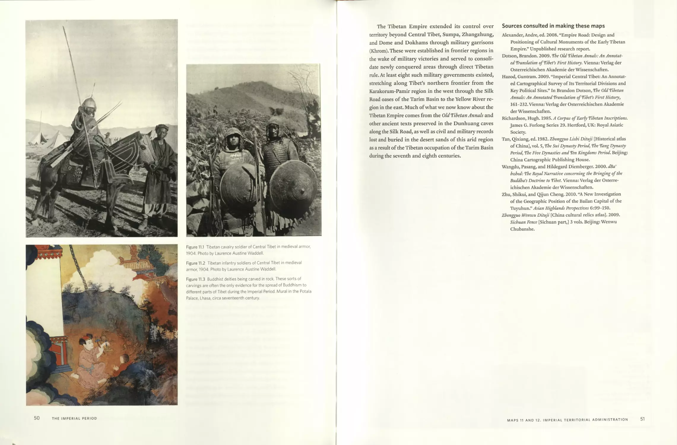
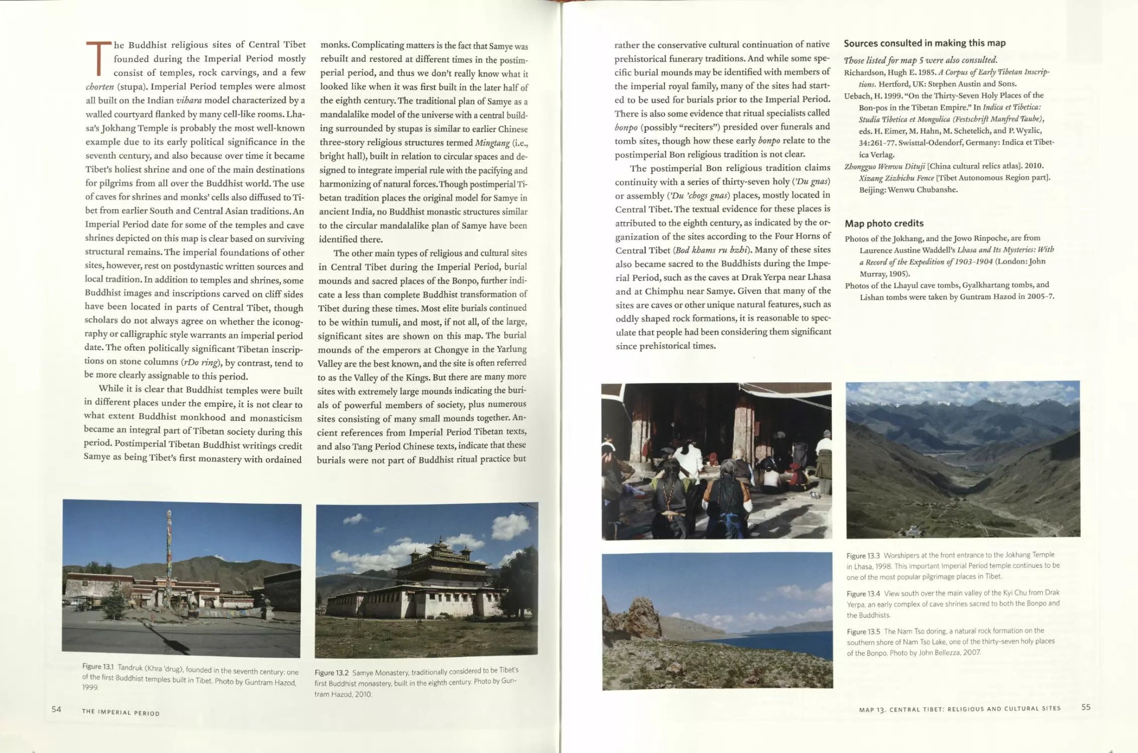
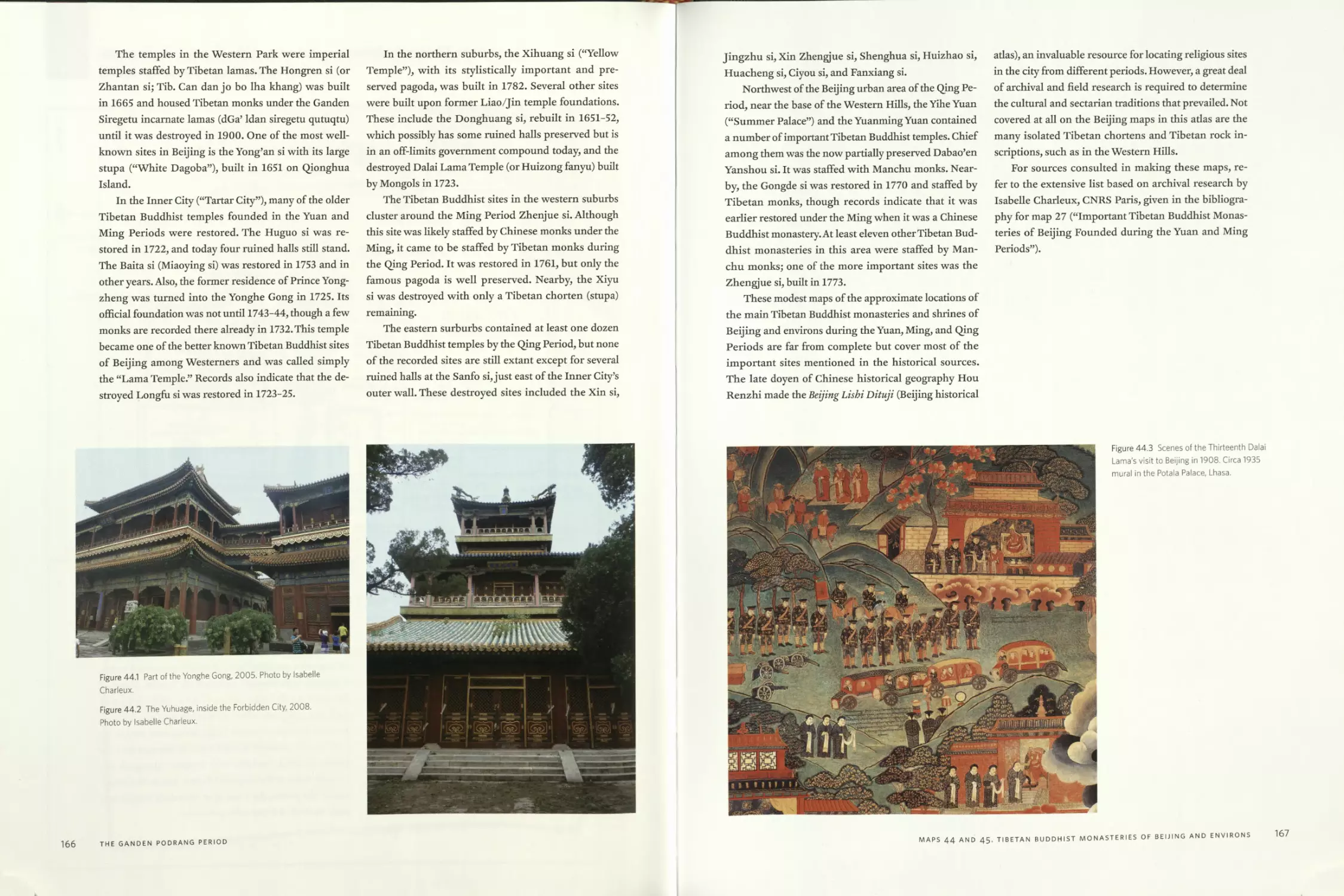
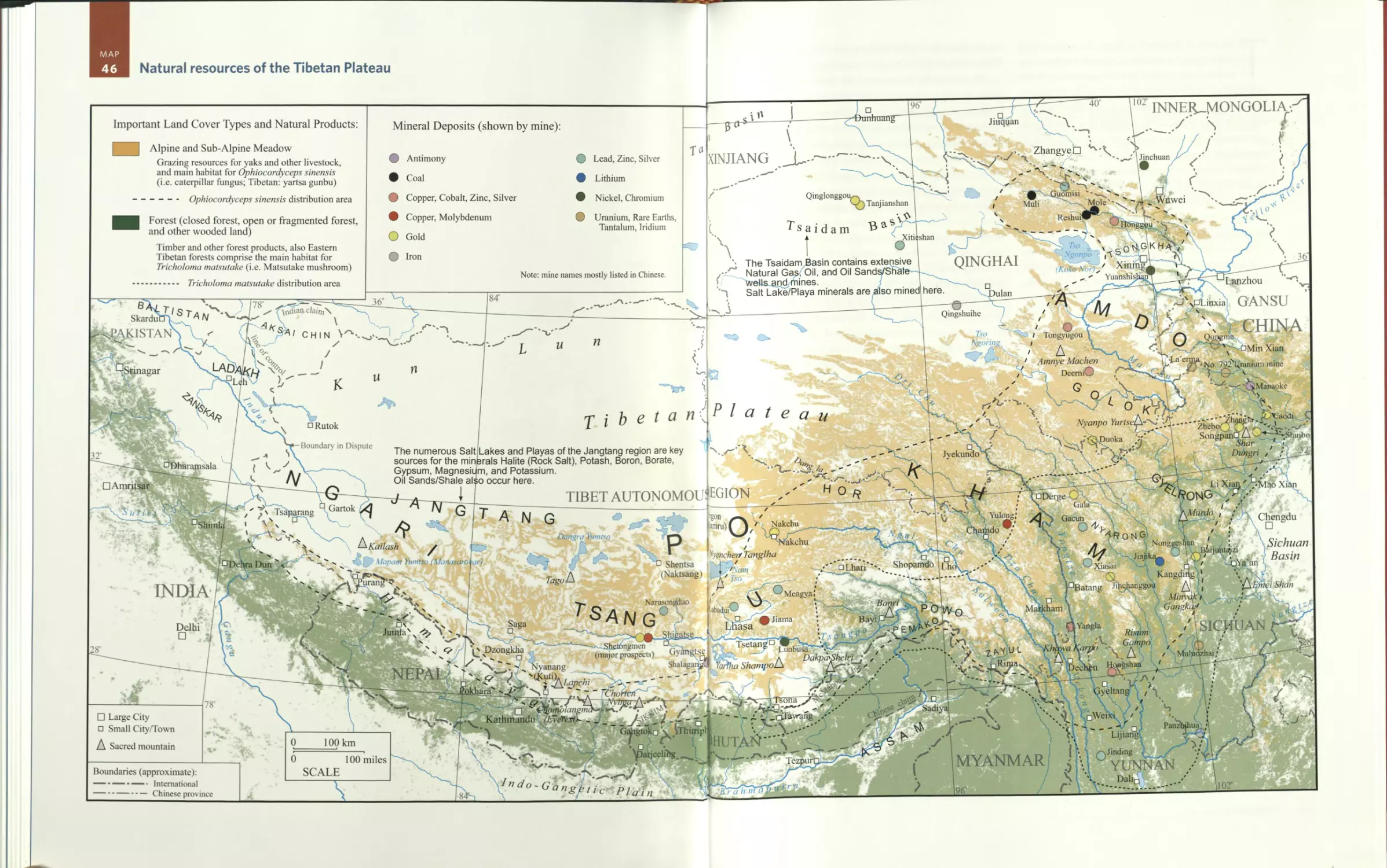
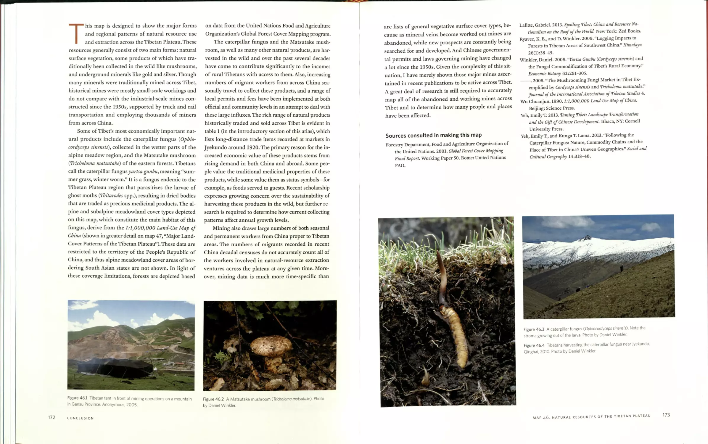
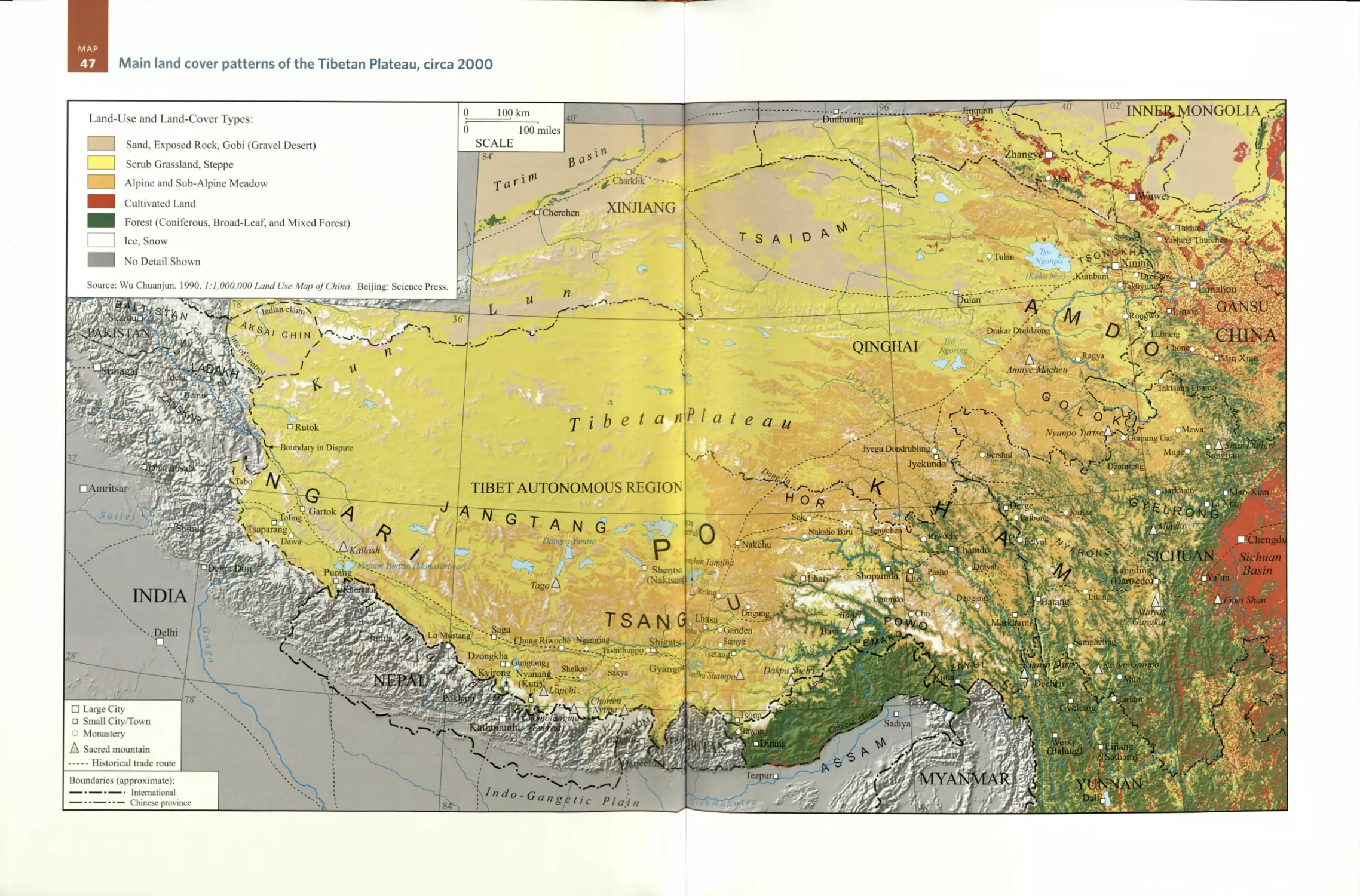
/


Текст
A Historical Atlas
./TIBET
KARL E. RYAVEC
Karl E. Ryavec is associate professor of world heritage at the University of California,
Merced.
The University of Chicago Press, Chicago 60637
The University of Chicago Press, Ltd., London
© 2015 by The University of Chicago
AH maps © 2015 Karl E. Ryavec
All rights reserved. Published 2015.
Printed in Canada
24 23 22 21 20 19 18 17 16 15 1 2 3 4 5
ISBN-13:978-0-226-73244-2 (cloth)
ISBN-13:978-0-226-24394-8 (e-book)
DOI: 10.7208/chicago/9780226243948.001.0001
Library of Congress Cataloging-in-Publication Data
Ryavec, Karl E., author.
A historical atlas of Tibet / Karl E. Ryavec.
pages cm
© 2015 by The University of Chicago.
All maps © by Karl E. Ryavec.
Includes bibliographical references and index.
ISBN 978-0-226-73244-2 (cloth : alk. paper) - ISBN 978-0-226-24394-8 (e-book) 1. Tibet
Autonomous Region (China)—Historical geography—Maps. 2. Tibet Autonomous Region
(China)—History—Maps. I. Title
G2308.T5R9 2015
911'.515—dc23
2014038399
@ This paper meets the requirements of ANSI/NISO Z39.48-1992 (Permanence of Paper).
To my parents
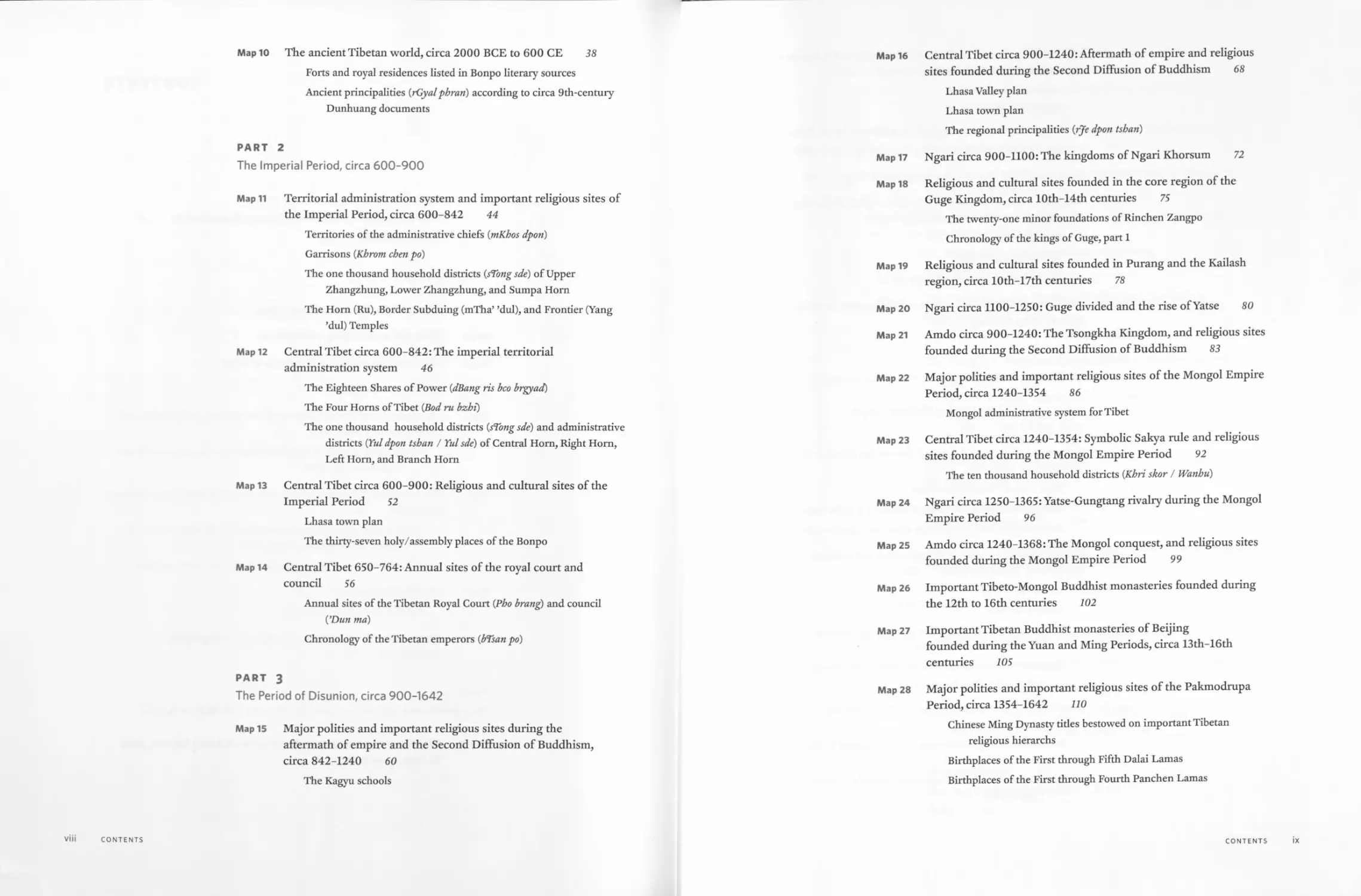
CONTENTS
Preface xiii
Notes on Gazetteer: Phonetic and Literary Romanization xv
A Note on Sources xvii
INTRODUCTION
Map 1 Tibet and the Tibetan culture region 3
Map 2 Tibet and surrounding civilizations 4
Map 3 Major regions and natural features of Tibet 6
Map 4 Tibetan macroregions 11
Map 5 The structure of Tibetan history: Core regions, peripheries, and
trade networks circa 1900 12
Graph of the growth of Buddhist temples and monasteries in core
regions ca. 600-1950
Map 6 The historical Tibetan world: Travel time and main trade patterns
circa 1900 18
Table 1. Long-distance trade items listed in the Yushu Diaocha Ji
(Yushu investigation record), 1919
A brief overview of the use and production of money in Tibet
Map 7 The Tibetic languages 26
Table 2. The Tibetic languages
Map 8 How to use this adas: Map coverage and cartographic
conventions 30
PART 1
The prehistorical and ancient periods, circa 30,000 BCE to 600 CE
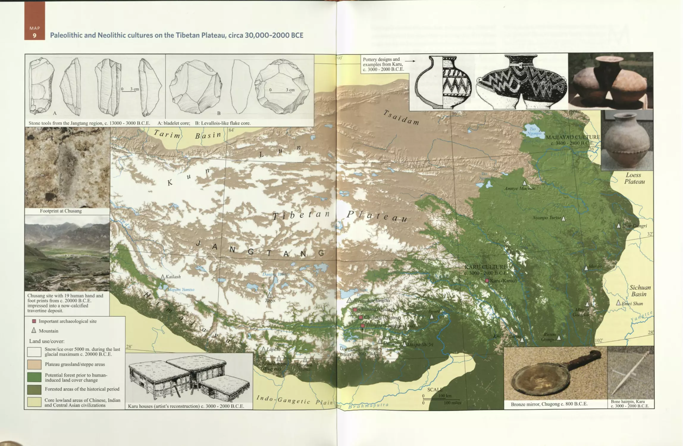
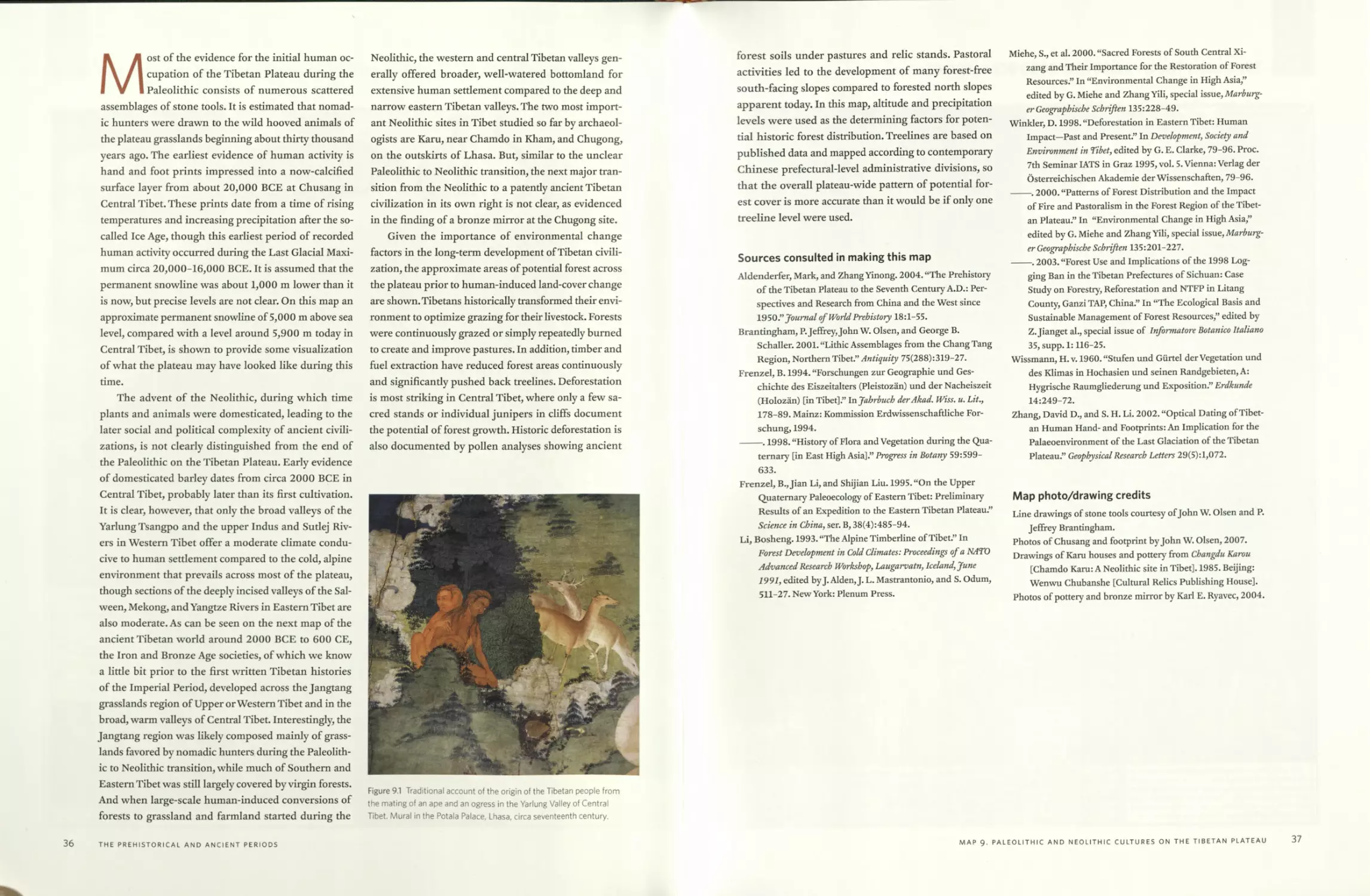
Map 9 Paleolithic and Neolithic cultures on the Tibetan Plateau, circa
30,000-2000 BCE 34
vii
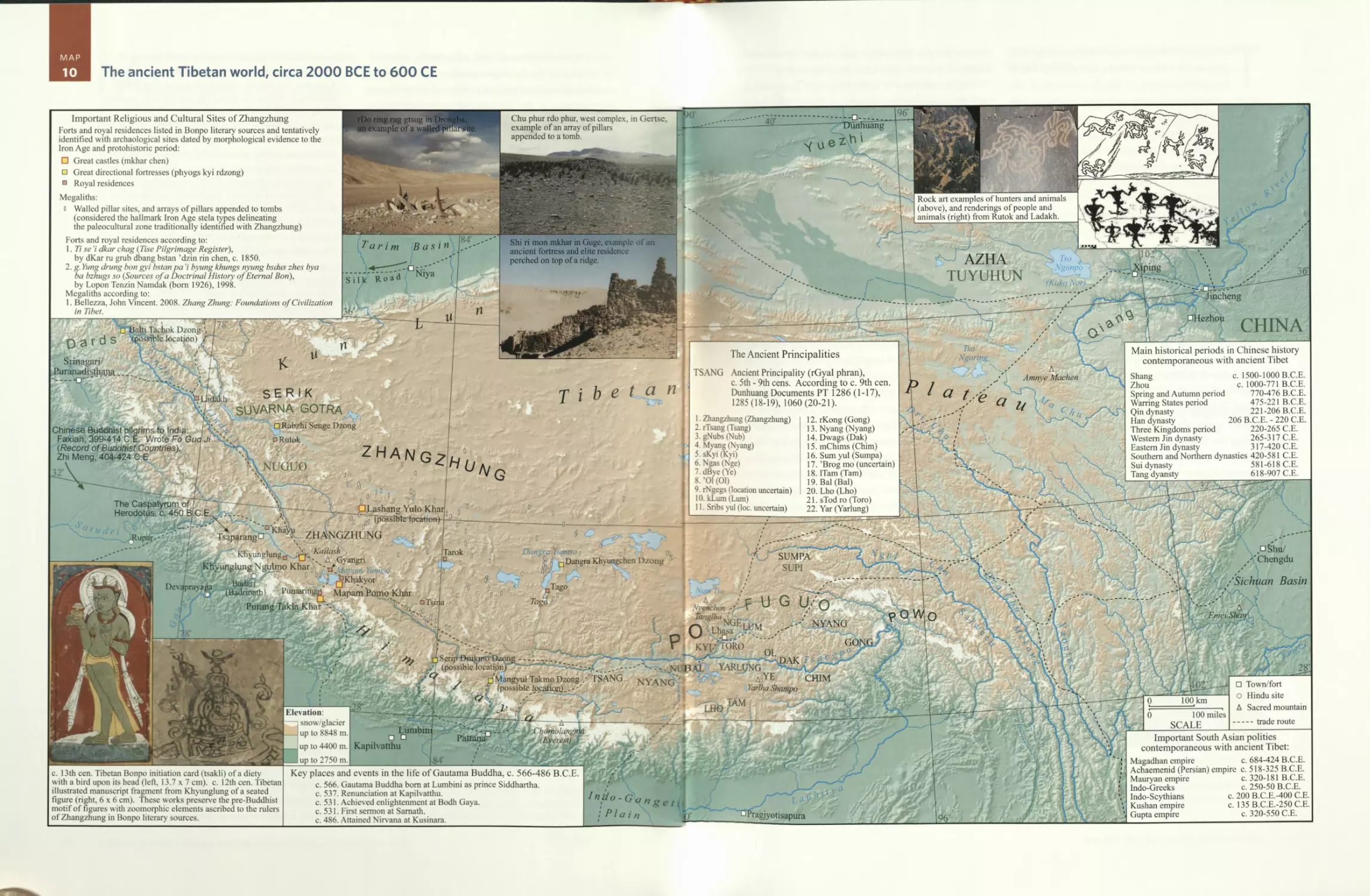
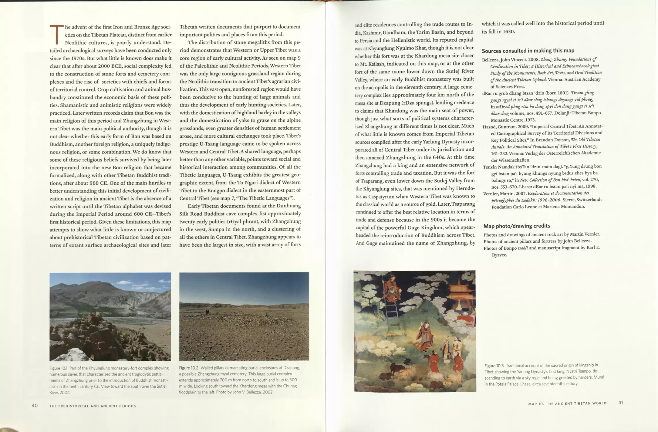
Map 10 The ancient Tibetan world, circa 2000 BCE to 600 CE 38
Forts and royal residences listed in Bonpo literary sources
Ancient principalities {rGyalpbran) according to circa 9th-century
Dunhuang documents
PART 2
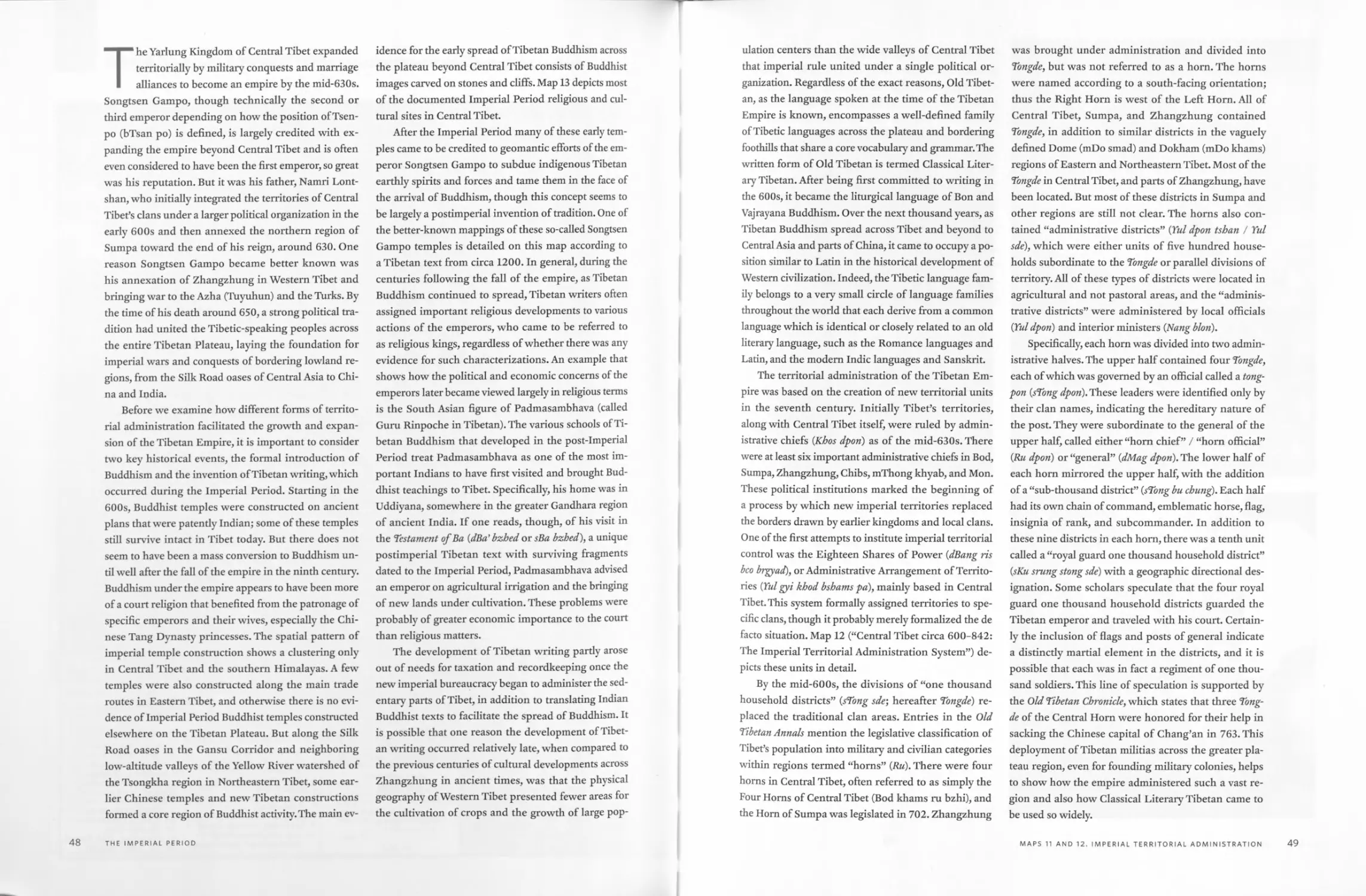
The Imperial Period, circa 600-900
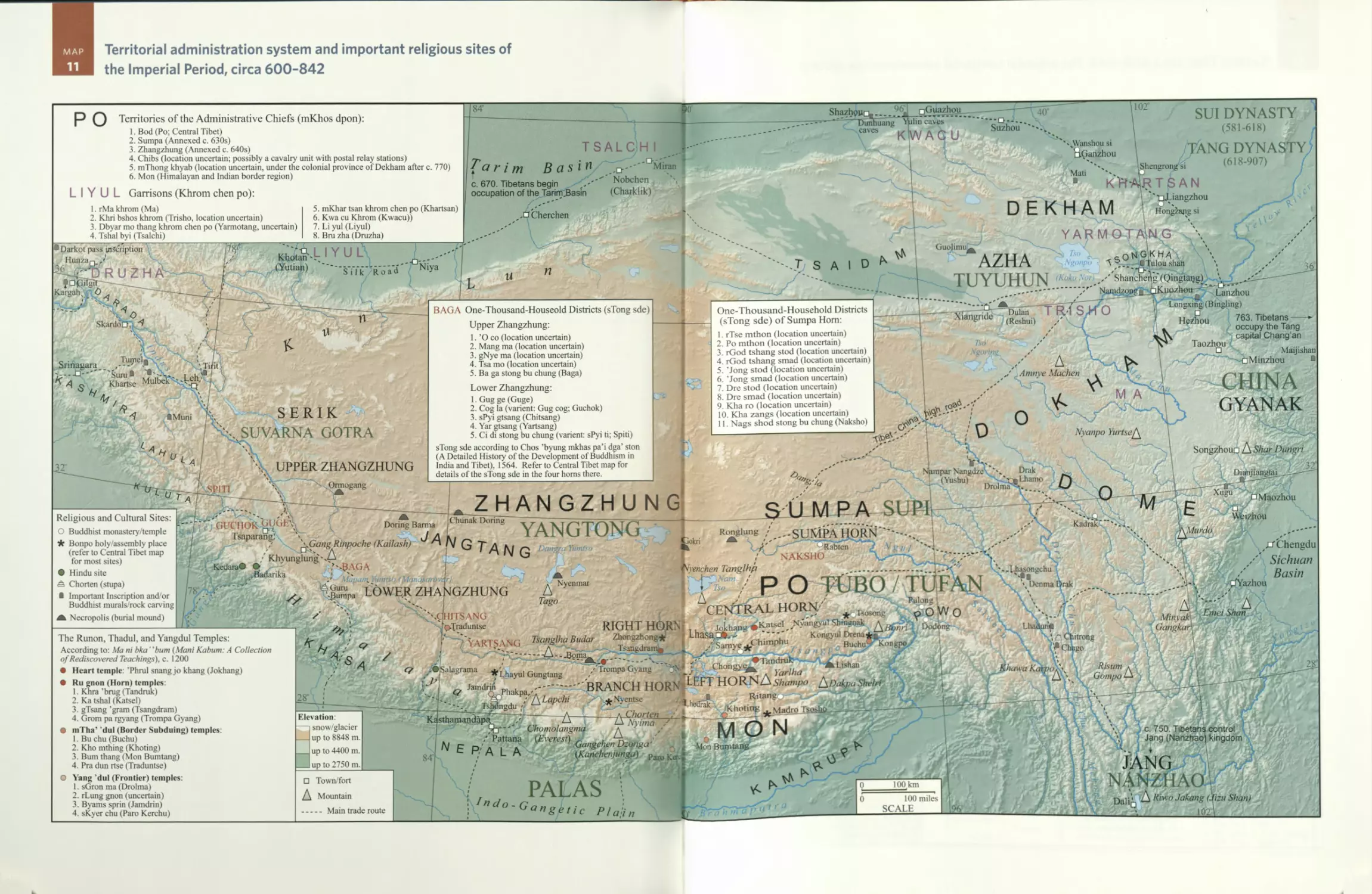
Map 11 Territorial administration system and important religious sites of
the Imperial Period, circa 600-842 44
Territories of the administrative chiefs {mKbos dpon)
Garrisons {Kbrom cben po)
The one thousand household districts {sTong sde) of Upper
Zhangzhung, Lower Zhangzhung, and Sumpa Horn
The Horn (Ru), Border Subduing (mTha’ ’dul), and Frontier (Yang
’dul) Temples
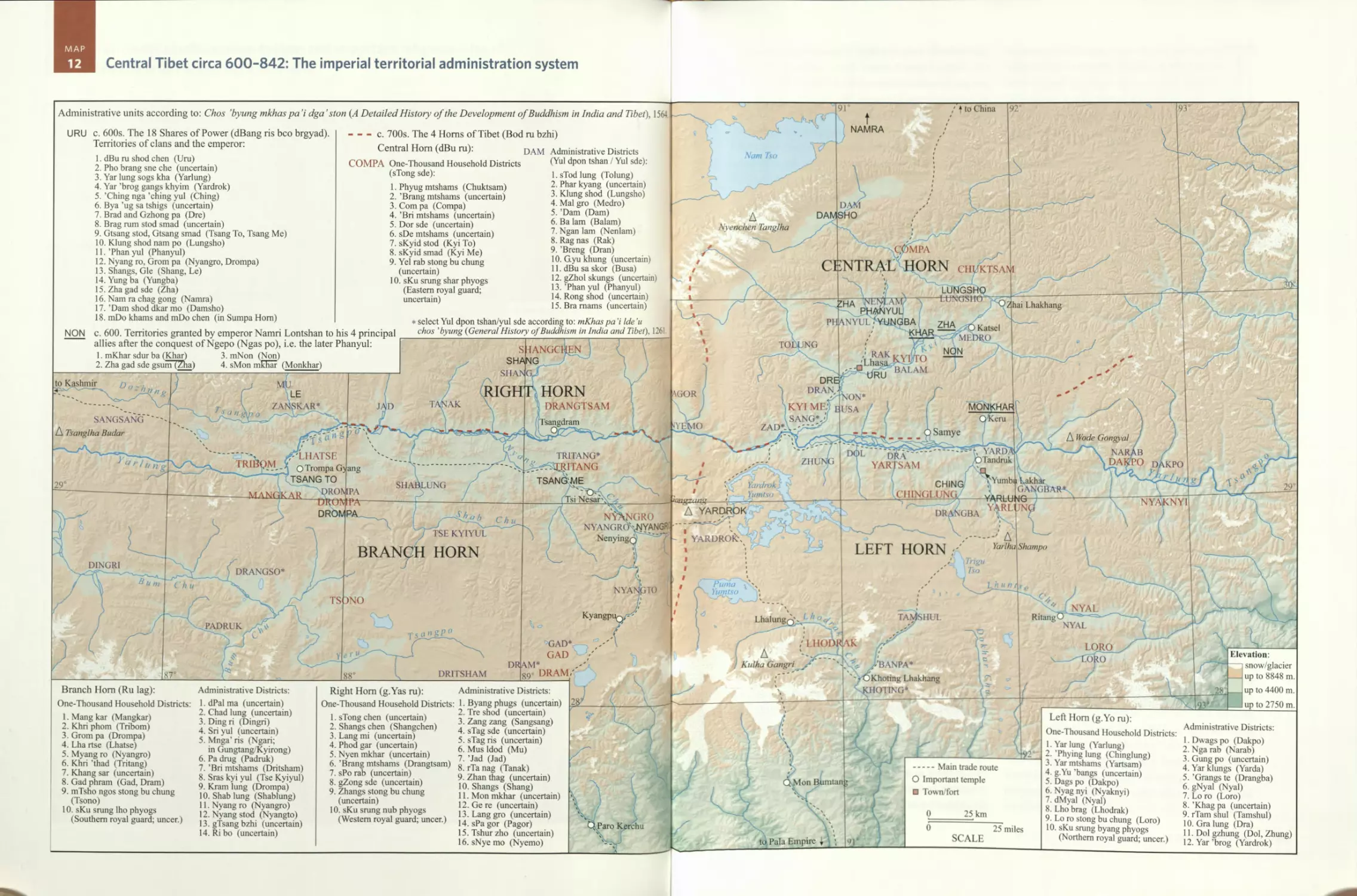
Map 12 Central Tibet circa 600-842: The imperial territorial
administration system 46
The Eighteen Shares of Power {dBang ris bco brgyad)
The Four Horns of Tibet {Bod ru bzbi)
The one thousand household districts {sTong sde) and administrative
districts {Yul dpon tsban / Yul sde) of Central Hom, Right Hom,
Left Horn, and Branch Hom
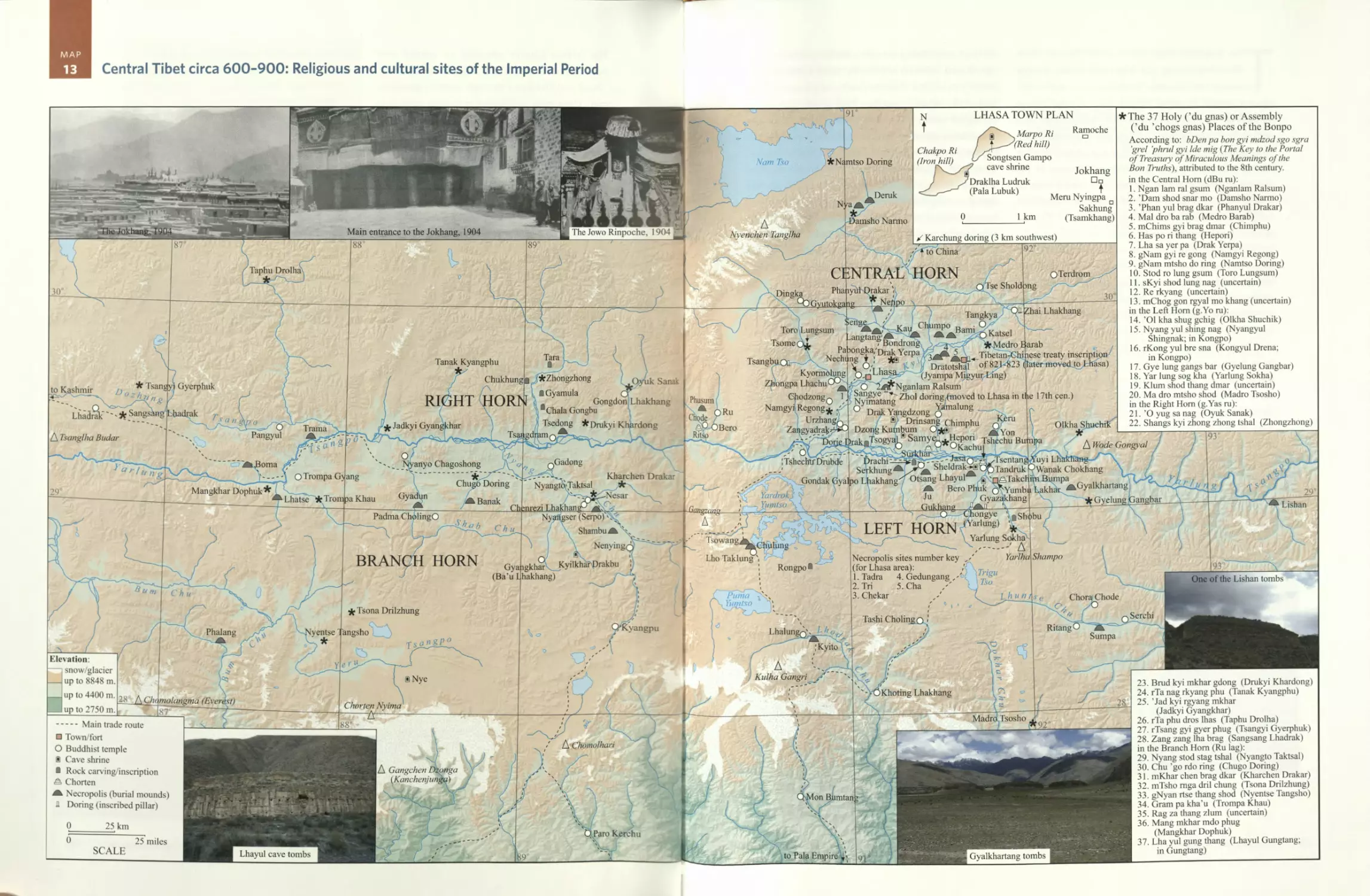
Map 13 Central Tibet circa 600-900: Religious and cultural sites of the
Imperial Period 52
Lhasa town plan
The thirty-seven holy/assembly places of the Bonpo
Map 14 Central Tibet 650-764: Annual sites of the royal court and
council 56
Annual sites of the Tibetan Royal Court {Pbo brang) and council
{'Dun ma)
Chronology of the Tibetan emperors {frTsan po)
PART 3
The Period of Disunion, circa 900-1642
Map 15 Major polities and important religious sites during the
aftermath of empire and the Second Diffusion of Buddhism,
circa 842-1240 60
The Kagyu schools
viii
CONTENTS
Map 16 Central Tibet circa 900-1240: Aftermath of empire and religious
sites founded during the Second Diffusion of Buddhism 68
Lhasa Valley plan
Lhasa town plan
The regional principalities (rje dpon tsban)
Map 17 Ngari circa 900-1100: The kingdoms of Ngari Khorsum 72
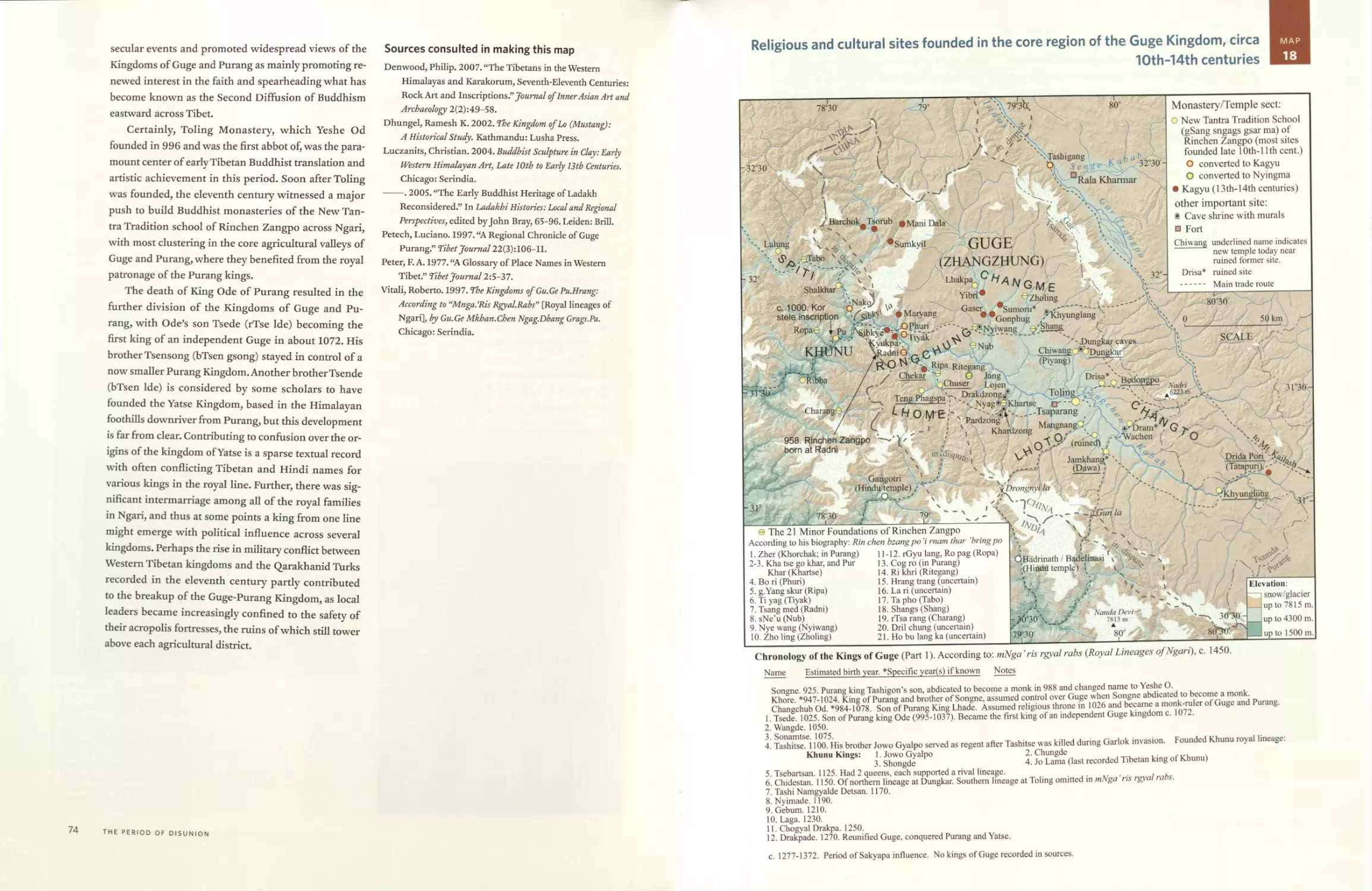
Map 18 Religious and cultural sites founded in the core region of the
Guge Kingdom, circa 10th-14th centuries 75
The twenty-one minor foundations of Rinchen Zangpo
Chronology of the kings of Guge, part 1
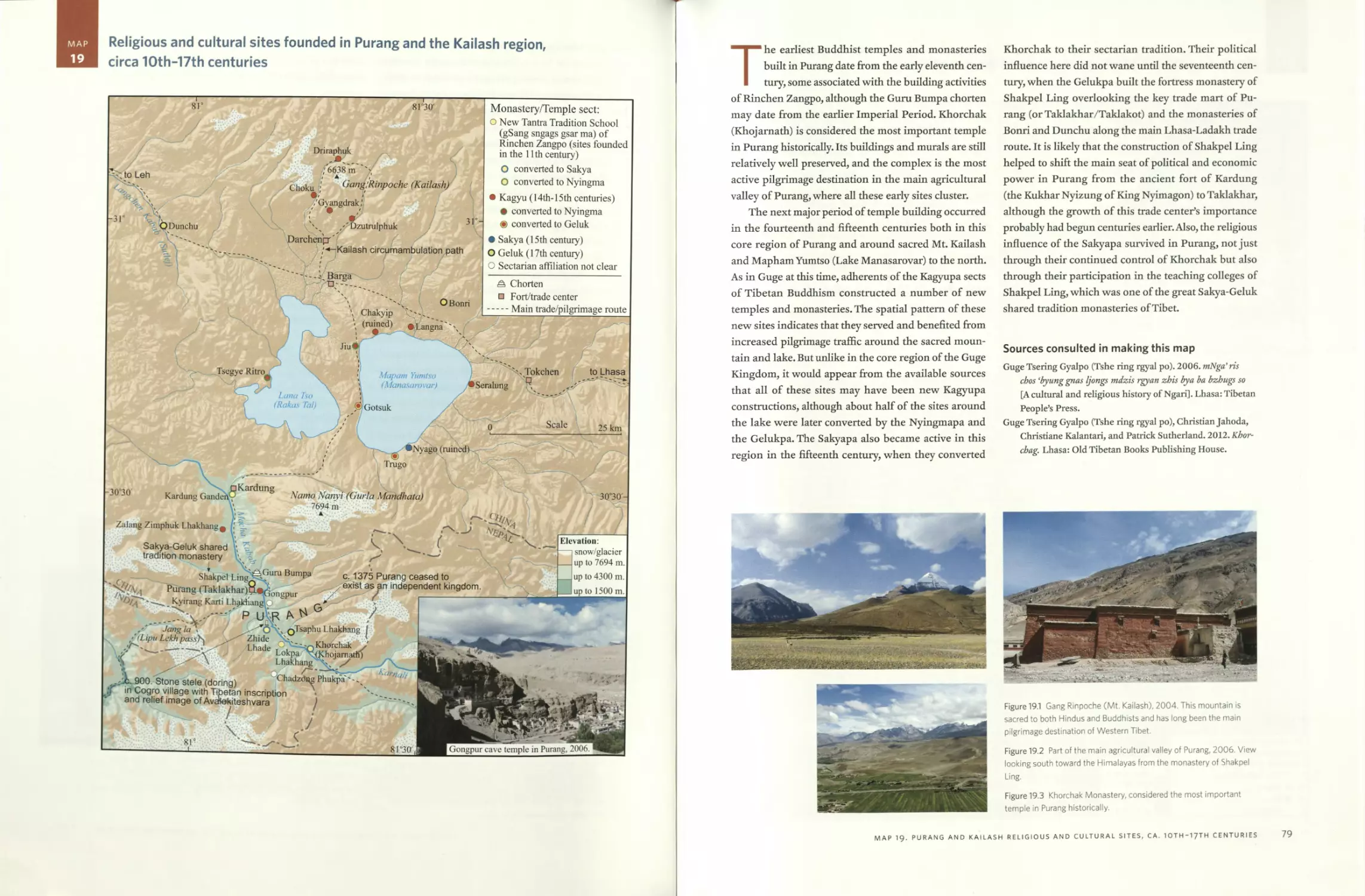
Map 19 Religious and cultural sites founded in Purang and the Kailash
region, circa 10th-17th centuries 78
Map 20 Ngari circa 1100-1250: Guge divided and the rise of Yatse 80
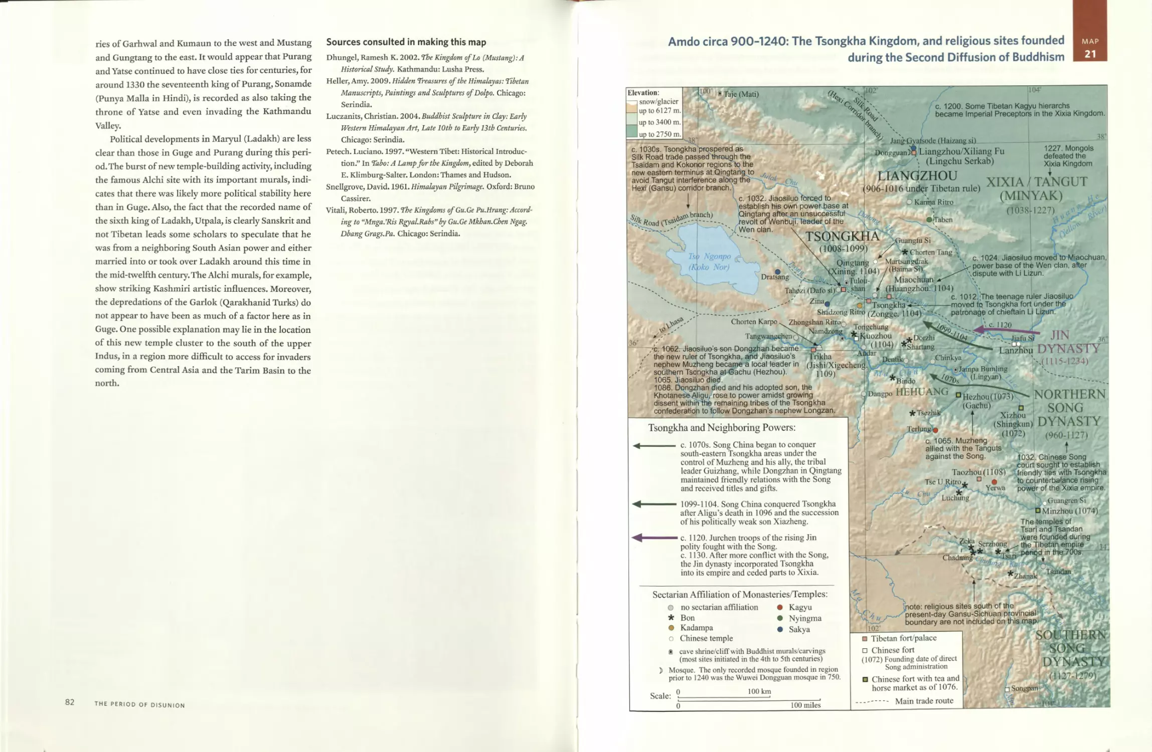
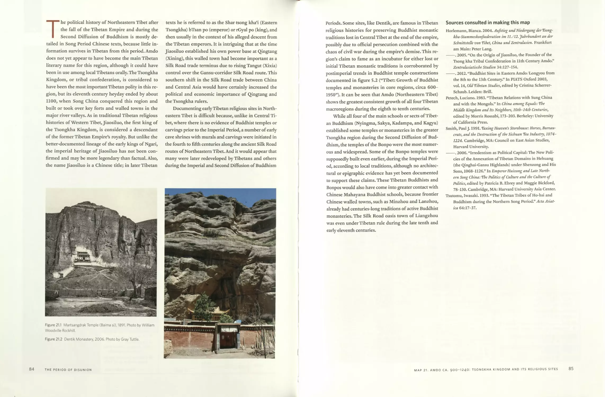
Map 21 Amdo circa 900-1240: The Tsongkha Kingdom, and religious sites
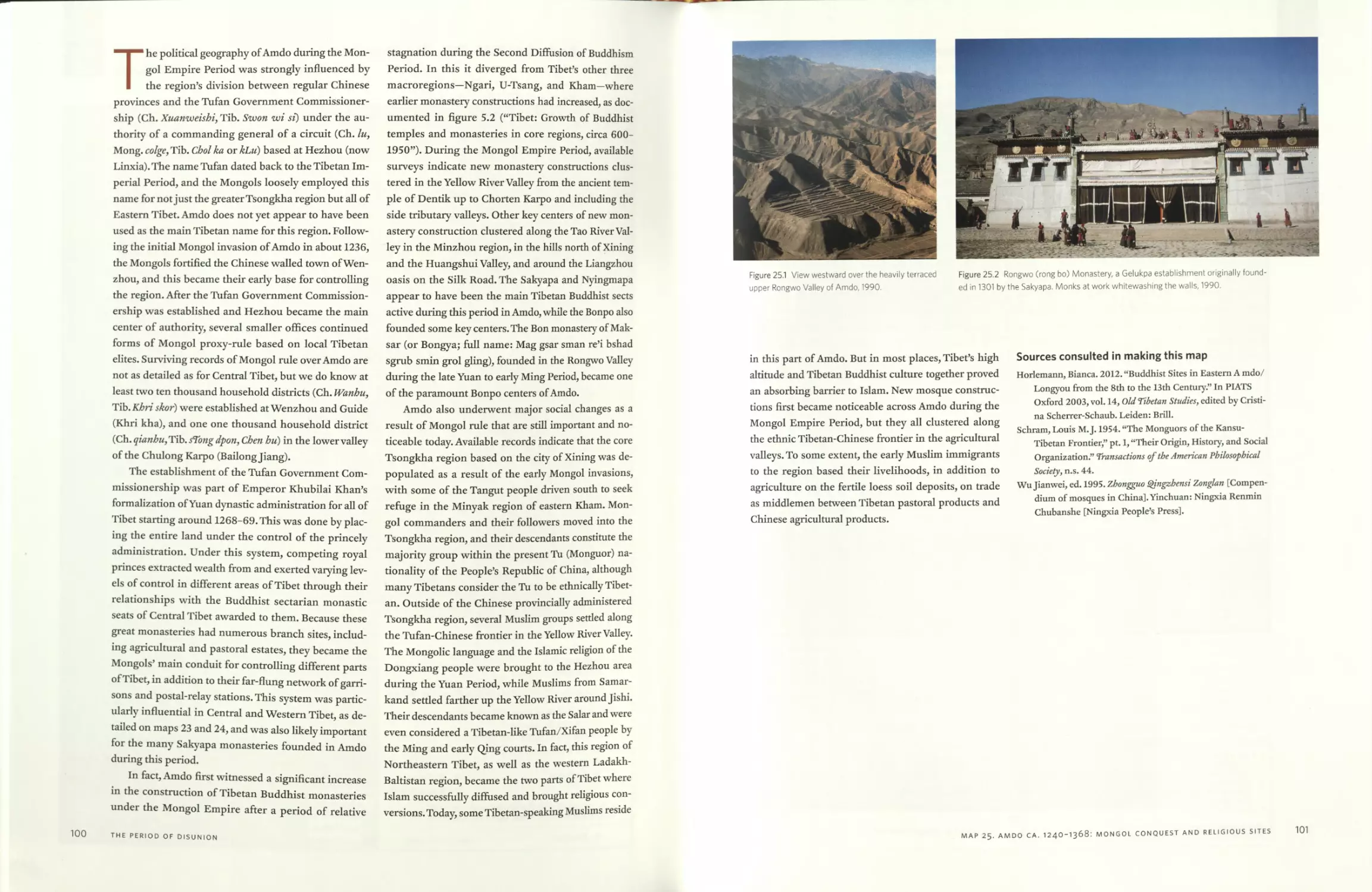
founded during the Second Diffusion of Buddhism 83
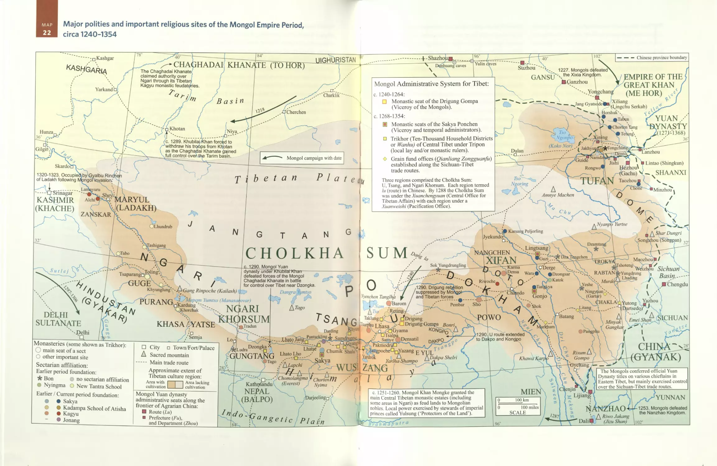
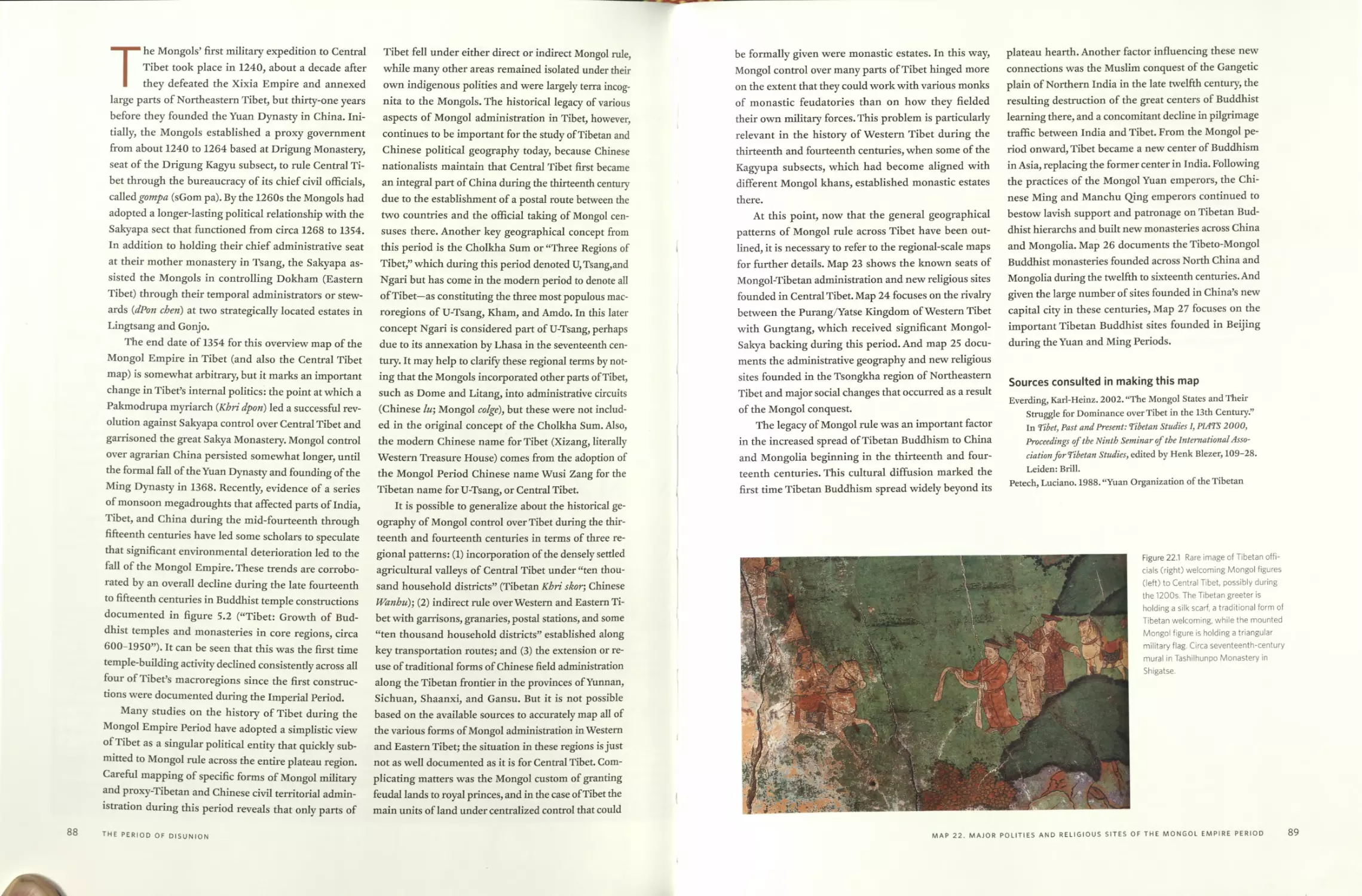
Map 22 Major polities and important religious sites of the Mongol Empire
Period, circa 1240-1354 86
Mongol administrative system for Tibet
Map 23 Central Tibet circa 1240-1354: Symbolic Sakya rule and religious
sites founded during the Mongol Empire Period 92
The ten thousand household districts (Kbri skor / Wanhu)
Map 24 Ngari circa 1250-1365: Yatse-Gungtang rivalry during the Mongol
Empire Period 96
Map 25 Amdo circa 1240-1368: The Mongol conquest, and religious sites
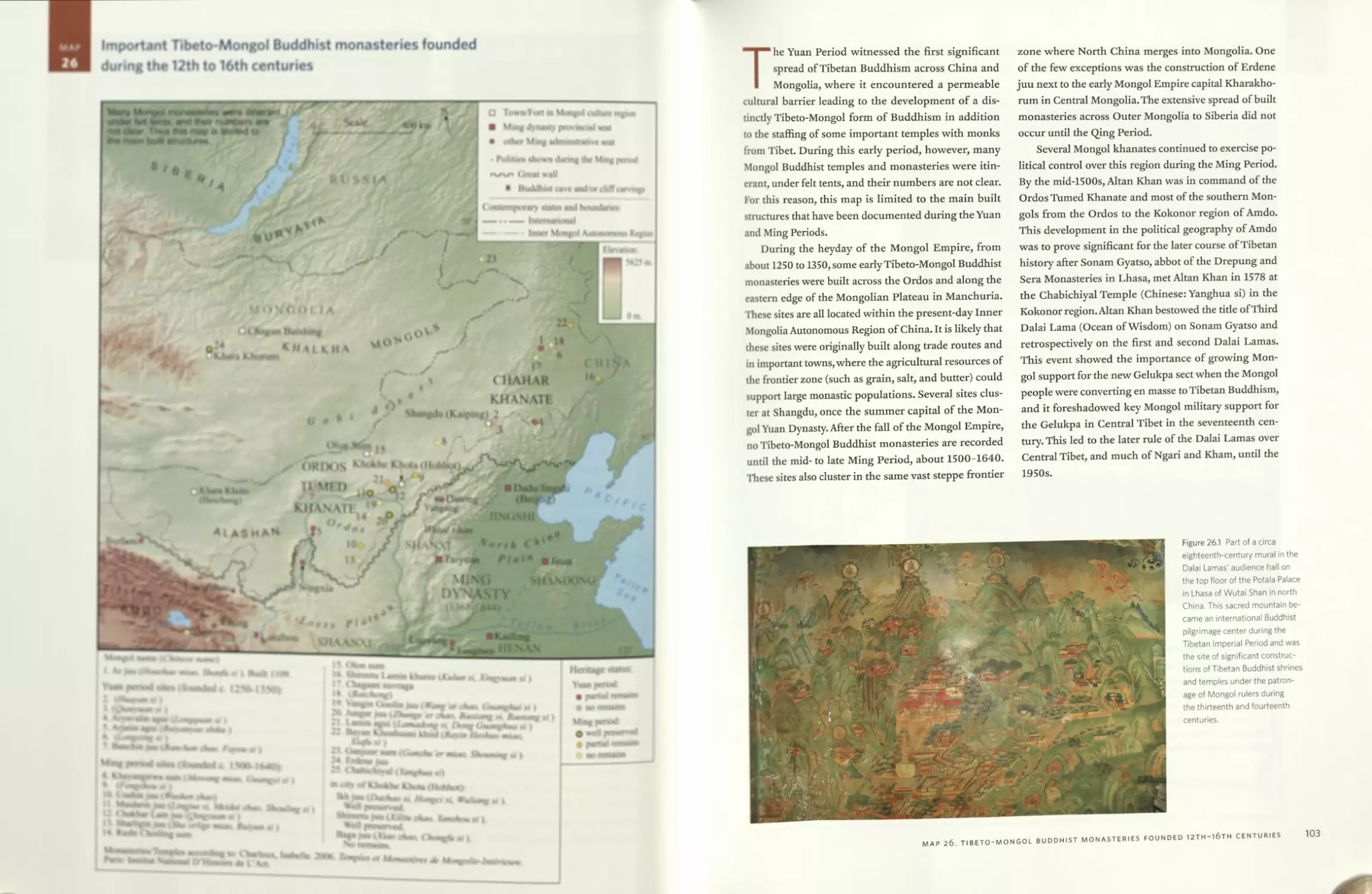
founded during the Mongol Empire Period 99
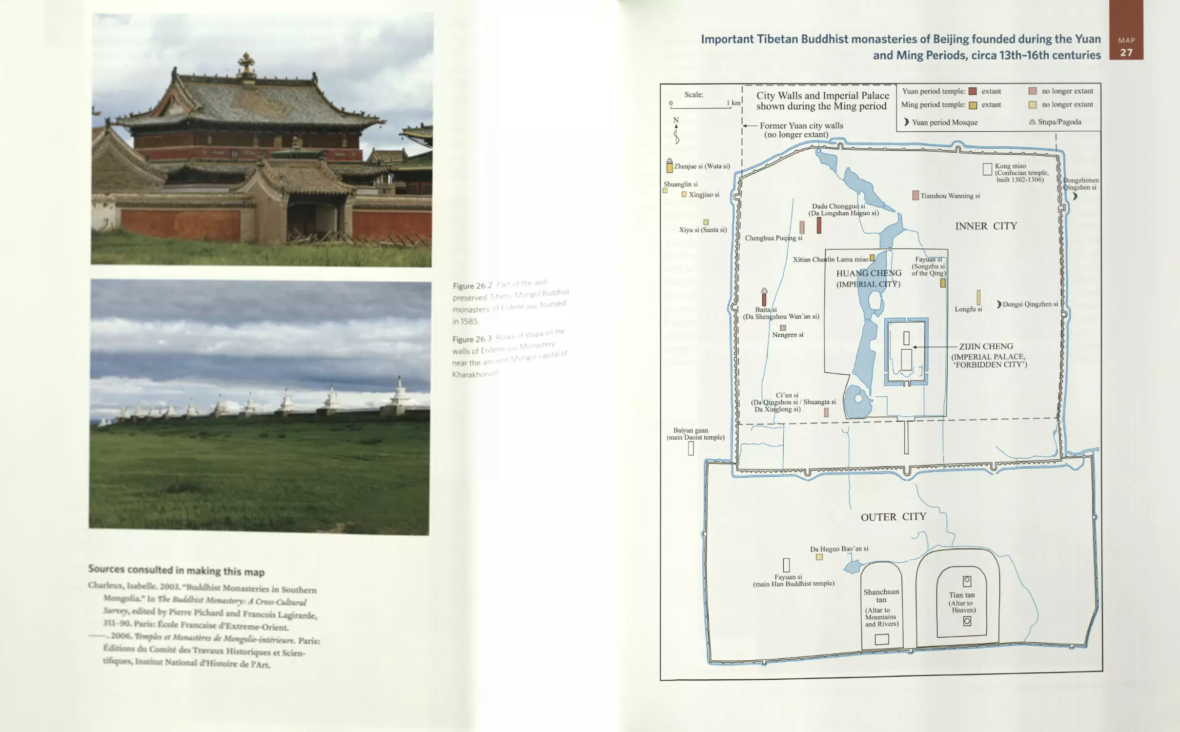
Map 26 Important Tibeto-Mongol Buddhist monasteries founded during
the 12th to 16th centuries 102
Map 27 Important Tibetan Buddhist monasteries of Beijing
founded during the Yuan and Ming Periods, circa 13th-16th
centuries 105
Map 28 Major polities and important religious sites of the Pakmodrupa
Period, circa 1354-1642 110
Chinese Ming Dynasty tides bestowed on important Tibetan
religious hierarchs
Birthplaces of the First through Fifth Dalai Lamas
Birthplaces of the First through Fourth Panchen Lamas
CONTENTS
ix
Map 29 Central Tibet circa 1354-1642: Rival powers and religious sites
founded during the Pakmodrupa Period 114
Lhasa Valley plan
Lhasa town plan
Fortresses (rDzong) established circa 1350-60 by the Pakmodrupa
Principal fiefs and estates of the Pakmodrupa, circa 1300s
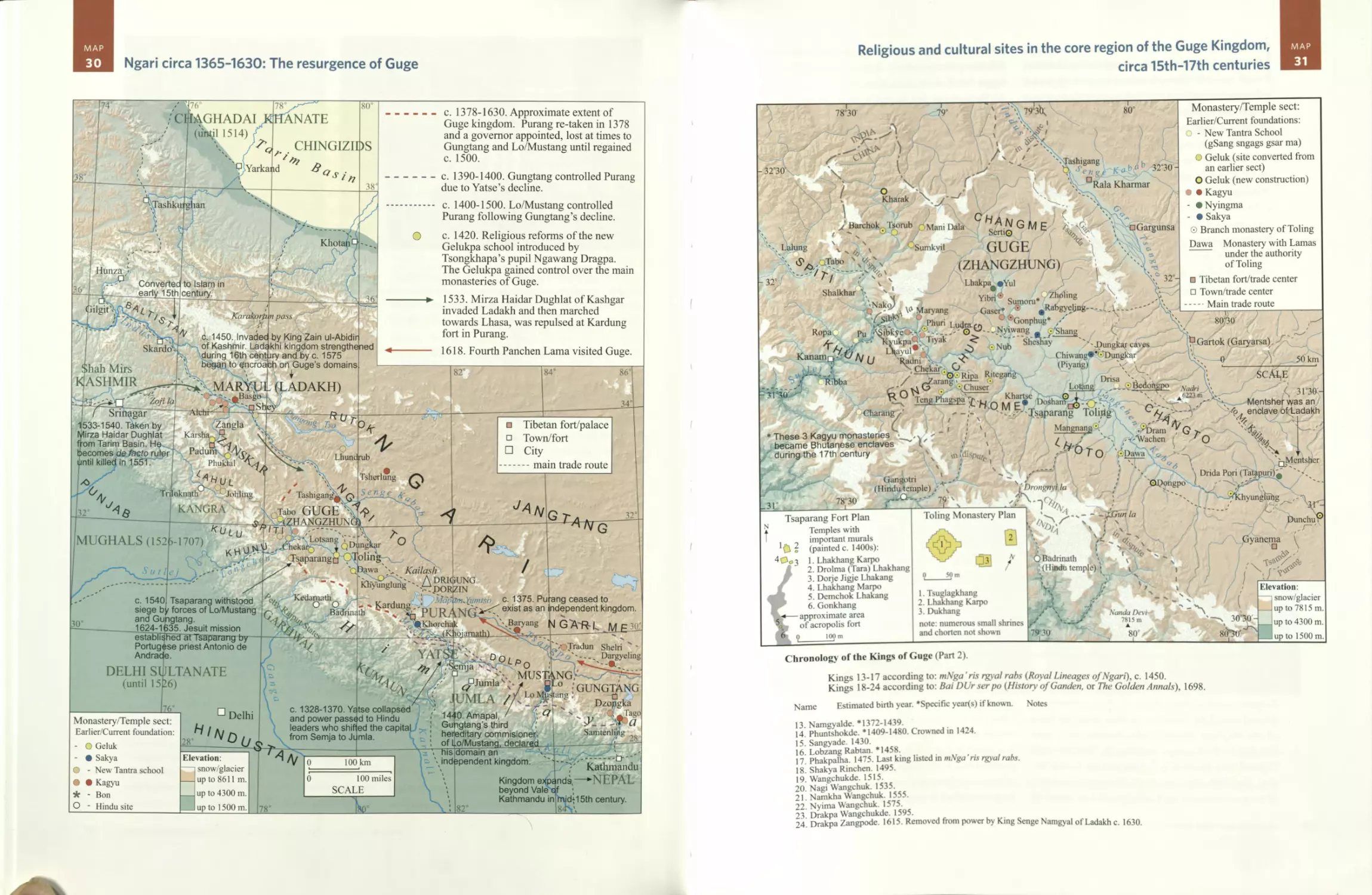
Map 30 Ngari circa 1365-1630: The resurgence of Guge 118
Map 31 Religious and cultural sites in the core region of the Guge
Kingdom, circa 15th-17th centuries 119
Tsaparang Fort plan
Toling Monastery plan
Chronology of the kings of Guge, part 2
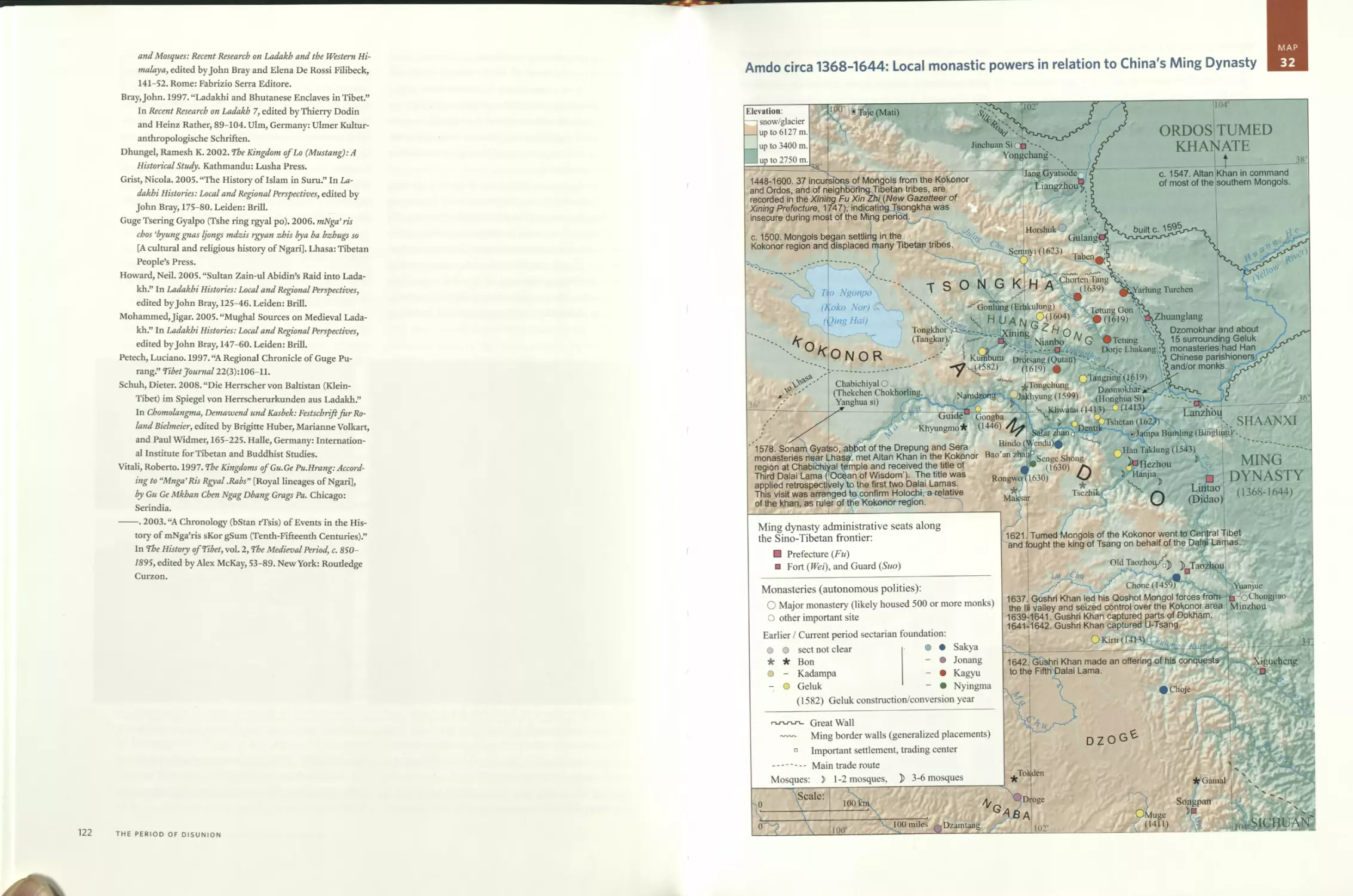
Map 32 Amdo circa 1368-1644: Local monastic powers in relation to
China’s Ming Dynasty 123
PART 4
The Ganden Podrang Period (Kingdom of the Dalai Lamas)
Map 33 Major polities of the Ganden Podrang Period,
circa 1642-1900 128
Map 34 Important religious and cultural sites of the Ganden Podrang
Period, circa 1642-1951 132
Main annual Tibetan trade fairs
Birthplaces of the Sixth through Fourteenth Dalai Lamas
Birthplaces of the Fifth through Eleventh Panchen Lamas
Map 35 Central Tibet circa 1642-1951: Religious and cultural sites of
the Ganden Podrang Period 134
Lhasa Valley plan
Lhasa town plan
Fortresses (rDzong) of the Ganden Podrang government’s territorial
administration system circa 1830
Fortresses and estates supervised by the Tashi Lhunpo Monastic
Corporation (bLa brang) until 1923
Map 36 Frontiers and forts of the Ganden Podrang Period,
circa 1900-1951 138
Fortresses (rDzong) and estates (gZhis ka) staffed by lay or
ecclesiastic governors
Boundaries of the Simla Convention signed by Great Britain and
Tibet in 1914
x
CONTENTS
Map 37 Central Tibet circa 1912-1951: The territorial administration
system of the Ganden Podrang government 140
Fortresses (rDzong) and estates (gZhis ka) staffed by lay or
ecclesiastic governors
Map 38 Ngari circa 1630-1959: Incorporation into Tibet’s Ganden
Podrang administrative system 144
Map 39 Amdo circa 1644-1911: Local monastic powers in relation to
China’s Qing Dynasty 147
Map 40 Kham circa 1642-1911: The Khampa polities in relation to
Central Tibet and China 150
Main polities of Eastern Kham and Gyelrong
The Thirty-Nine Hor Tribes
Map 41 The Derge Kingdom: Territorial administration system,
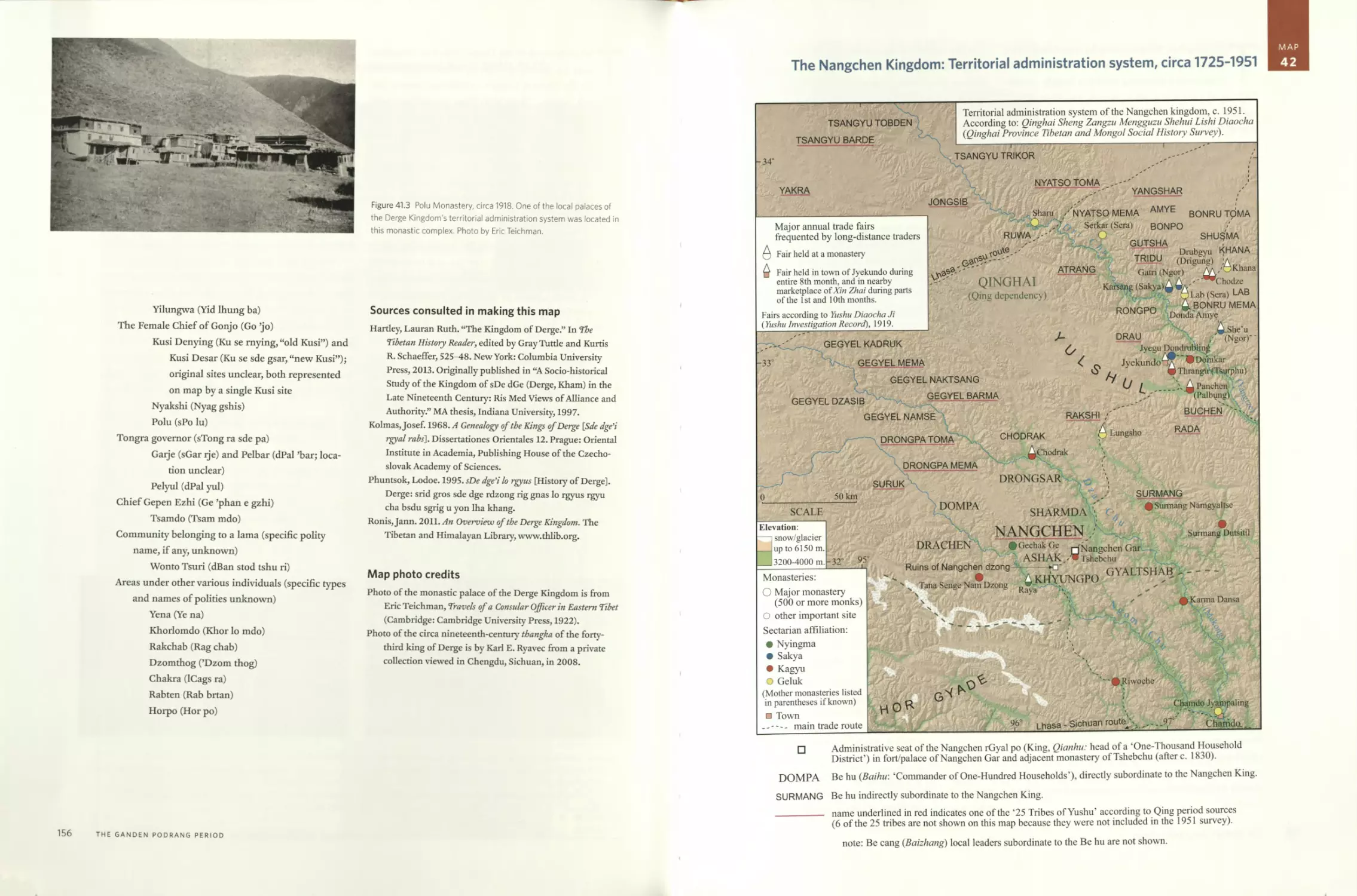
circa 1630-1909 154
Forts and palaces of the Derge Kingdom
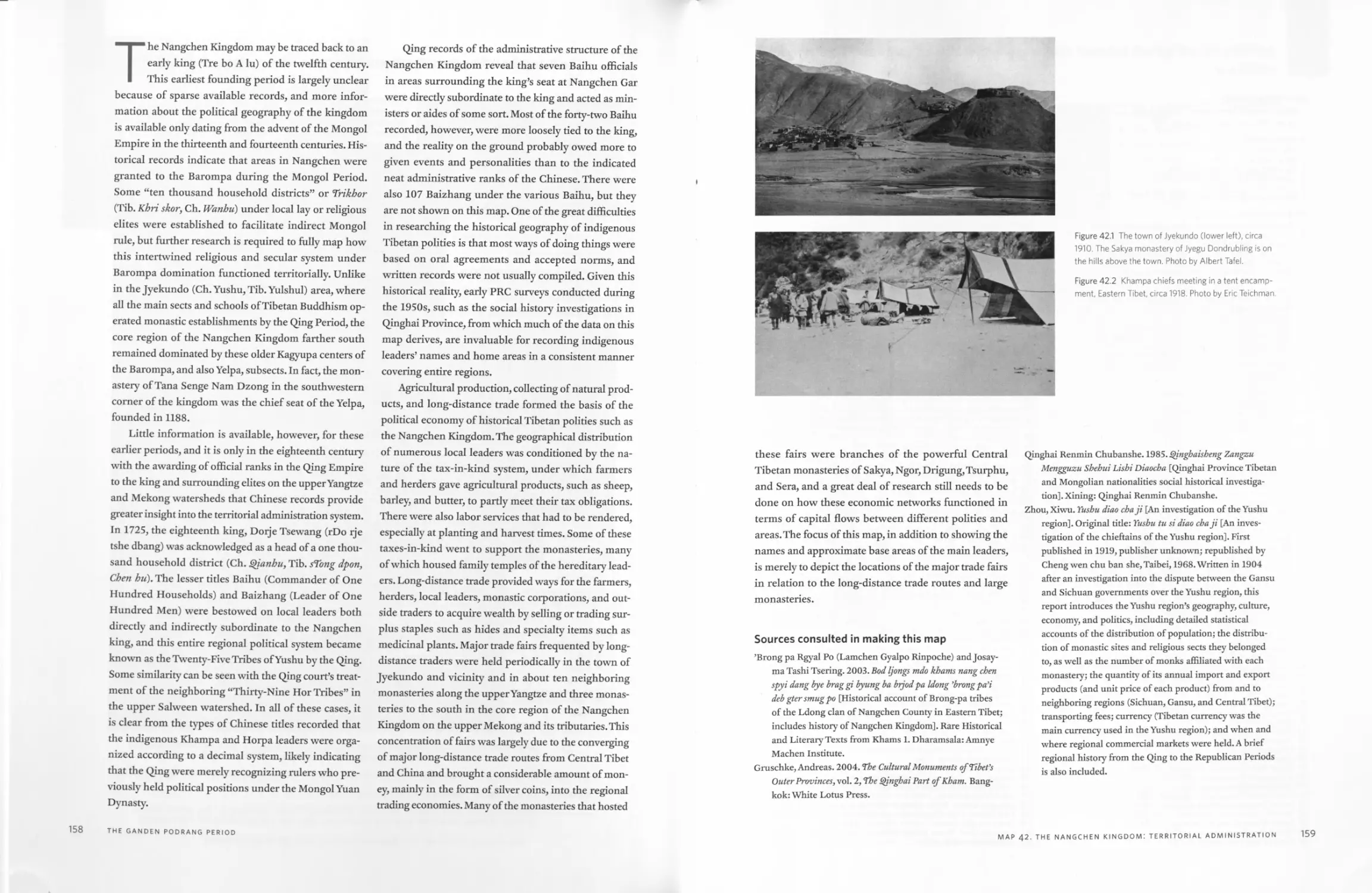
Map 42 The Nangchen Kingdom: Territorial administration system,
circa 1725-1951 157
The one hundred household districts (Be hu / Baihu)
The twenty-five tribes of Yushu
Major annual trade fairs frequented by long-distance traders
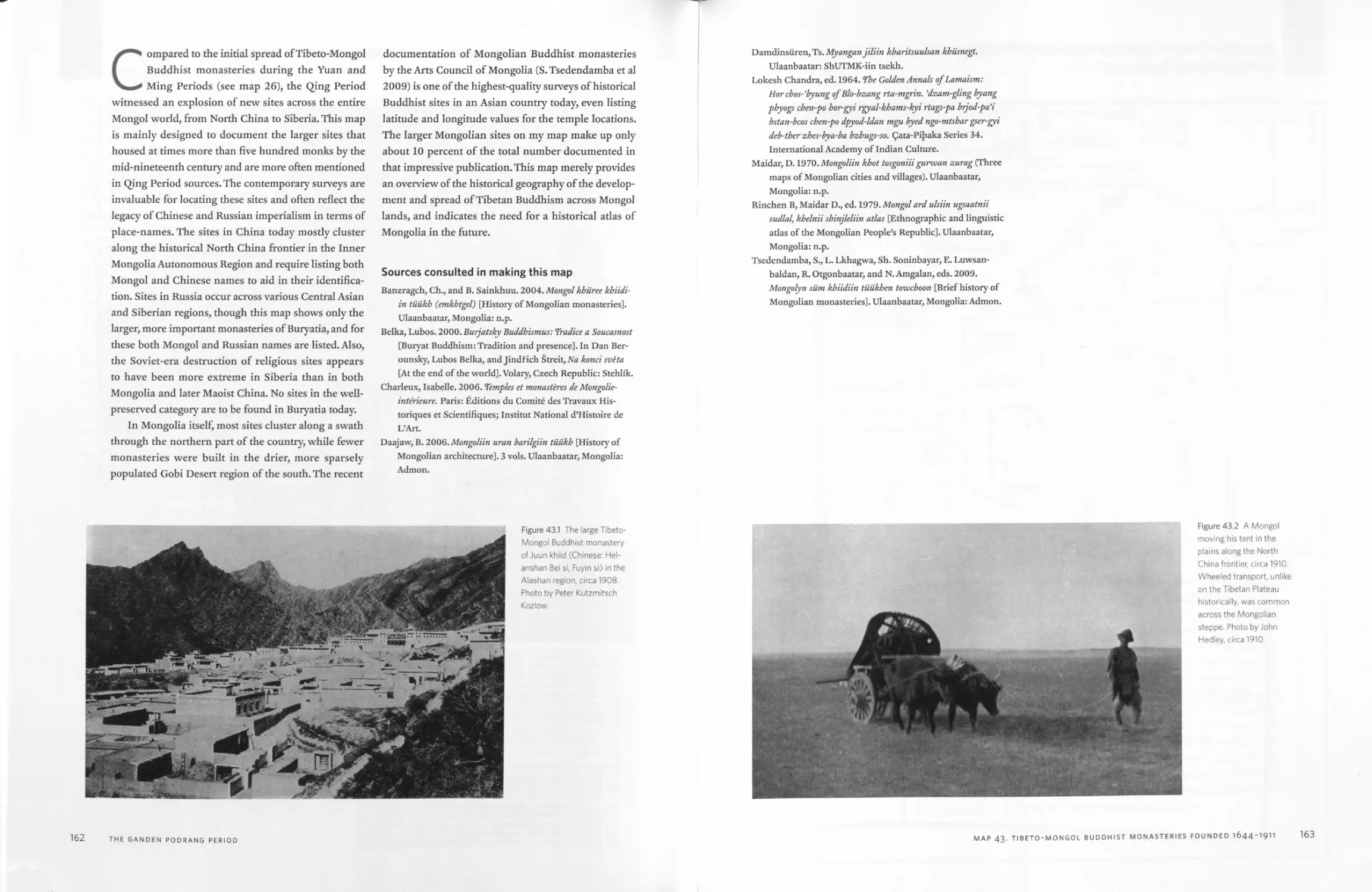
Map 43 Important Tibeto-Mongol Buddhist monasteries founded during
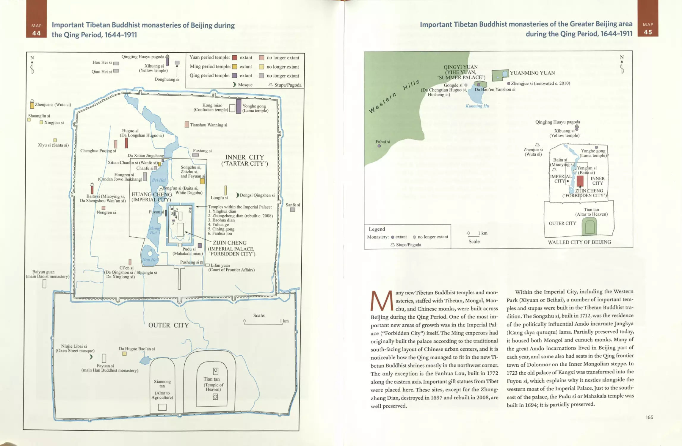
the Qing Period, 1644-1911 161
Map 44 Important Tibetan Buddhist monasteries of Beijing during the
Qing Period, 1644-1911 164
Map 45 Important Tibetan Buddhist monasteries of the Greater Beijing
area during the Qing Period, 1644-1911 165
CONCLUSION
Map 46 Natural resources of the Tibetan Plateau 170
Map 47 Main land cover patterns of the Tibetan Plateau, circa 2000 174
Map 48 The Tibetan population, circa 2000 178
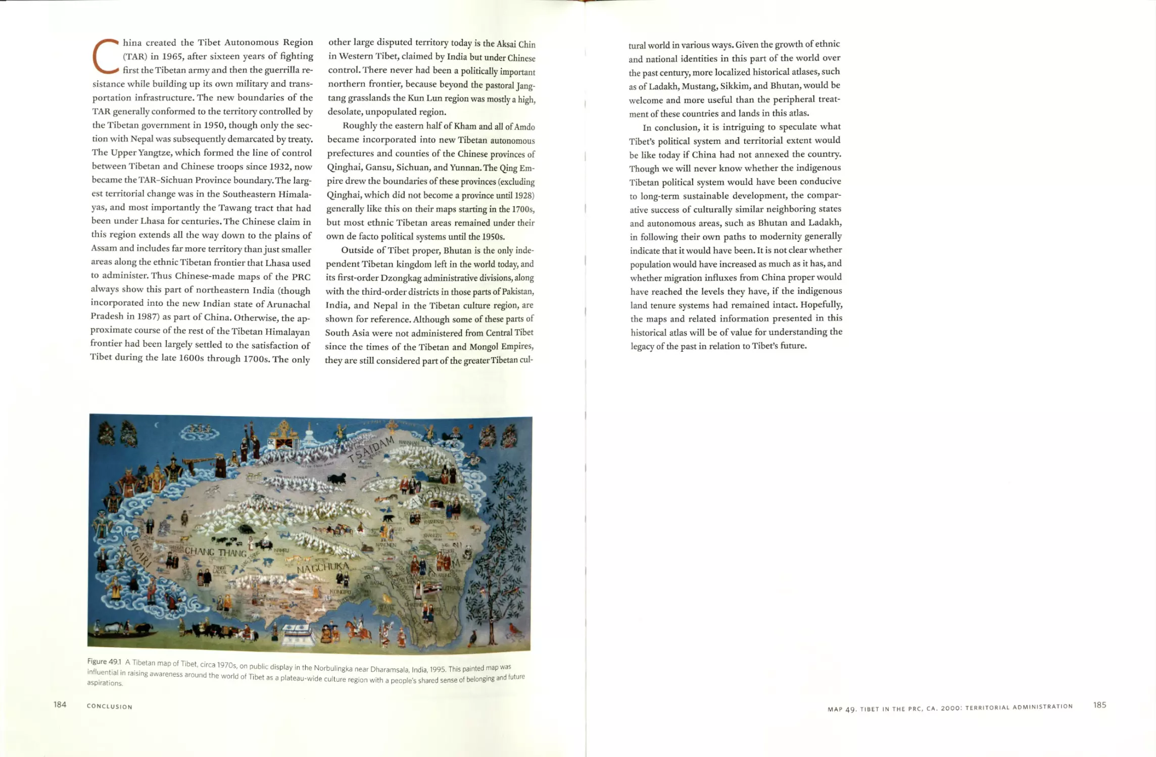
Map 49 Tibet in the People’s Republic of China, circa 2000:
The territorial administration system 182
Acknowledgments 187
Historical Photograph Sources 193
Index 195
CONTENTS Xi
PREFACE
This is the first historical atlas of Tibet to be
made. Though there have been some good car-
tographic surveys of cultural and religious sites
across the Tibetan Plateau and a wealth of studies on
historical Tibetan texts, a basic reference work like this
atlas has long been needed by students and scholars
interested in learning about Tibet. Peter Kessler’s his-
torical cultural atlases of some of the eastern Tibetan
polities were the first true historical atlases of specific
small parts of Tibet. And limited historical coverage of
Tibet was provided in Albert Hermann’s seminal His-
torical and Commercial Atlas of China published in 1935,
in Tan Qixiang’s Zhongguo Lishi Dituji (China histor-
ical atlas, 8 volumes, 1982), and in Joseph Schwartz-
berg’s A Historical Atlas of South Asia (1978). But in
these works Tibet is mapped as merely peripheral to
Asia’s large sedentary agricultural civilizations and not
from its own central position and perspective as a civ-
ilization in its own right. Thus I drew the maps and
wrote the text of this atlas to help meet the need for a
comprehensive series of maps showing the growth and
spread of Tibetan civilization in its entirety in relation
to important places, events, and connections between
regions.
I remember precisely how my idea to make this his-
torical atlas of Tibet first arose. It did so spontaneous-
ly when I was at the Chicago 2005 annual meeting of
the Association for Asian Studies talking with scholars
working on the China historical geographic infor-
mation system. This project was based on the above-
mentioned Zhongguo Lishi Dituji of Tan Qixiang, which
provided a template to copy from. But Tibet lacked any
such comprehensive historical atlas, so I decided then
and there that I was going to provide a clear set of
summary maps of the general course of Tibetan histo-
ry. This sudden decision, coupled with the feeling that
there was no time to waste, partly explains why this
historical atlas of Tibet is an independent work of one
scholar and not a large project with an editorial board
and armies of cartographers.
Making a historical atlas of a civilization for the
first time has presented some advantages amidst sev-
eral disadvantages. On the bright side, each map I
made was often valued by those colleagues I shared it
with as a new resource, and there was usually no simi-
larly detailed map to compare the accuracies or errors
against. But at the same time, I had little cartographic
material to study. Fortunately, as far back as 1993 when
I first embarked on doctoral research in geography, I
began to build up various spatial databases of cultur-
al and religious sites across Tibet. The results of the
subsequent twelve years of research and eight years
of mapmaking, combined with still more research and
database construction, are now finally presented in this
modest atlas. In retrospect, I wish I had another twenty
years to refine and improve this historical atlas, but I
believe it is now sufficient and hope others will find it
of some value.
xiii
NOTES ON GAZETTEER
Phonetic and Literary Romanization
Tibetan place-names on the maps in this atlas, par-
ticularly those of Buddhist temples and monas-
teries, may be searched for online at the Tibetan
Buddhist Resource Center (TBRC.org) to obtain the Ti-
betan orthography and related information about his-
torical persons and texts associated with the sites.
The Tibetan words and place-names in this adas are
rendered phonetically according to the general rules
proposed by the TBRC and the Tibetan and Himalayan
Library (THL). However, I have retained some of the
more well-known phonetic transcriptions of import-
ant places in Tibet used by the British and American
mapmaking authorities of the late nineteenth to mid-
twentieth centuries, such as Shigatse for Shikatse (gZhis
ka rtse), and Gyangtse for Gyantse (rGyal rtse), for the
sake of conventional cross-referencing with other his-
torical maps and adases.
Mention should also be made of the official Roman-
ization system promulgated by the People’s Republic
of China for phonetically transcribing Tibetan place-
names (NSM 1986). According to this system, Shigatse
is romanized as Xigaze, and Gyangtse as Gyangze, for
example.
When Tibetan words and place-names are listed in
literary transliteration preserving the original orthog-
raphy of the Tibetan spellings, I have followed the full
rules of the Wylie system (1959) and capitalized the
radical letter to indicate the pronunciation.
Chinese words and place-names are transcribed
according to the Pinyin system and are phonetically
rendered based on standard Mandarin pronunciation.
Literature Cited
National Survey Ministry (NSM). 1986. Zangyu Lhasa Hua
Diming Yiyin Guize (Tibetan Lhasa dialect place-name
transcription rules). Beijing: Survey Press.
Wylie, Turrell Verl. 1959. “A Standard System of Tibetan Tran-
scription.” Harvard Journal of Asiatic Studies 22:261-67.
xv
A NOTE ON SOURCES
Primary Tibetan sources are listed on the maps
themselves so that readers can more clearly relate
mapped features to the historical texts they were
recorded in.
Secondary sources, primarily Chinese and Western
contemporary scholarly works, are listed in the bibli-
ography for each map. Mainland Chinese works pub-
lished after 1949 are listed in Pinyin, but older works
cataloged in the West in the Wade-Giles system have
not been converted.
The only exception to this plan are the approxi-
mately twenty contemporary Tibetan and Chinese-text
survey volumes of Bonpo and Buddhist temples and
monasteries listed in the bibliography of map 5, “The
Structure of Tibetan History.” Given the large number
of these detailed volumes and that the sites they docu-
ment are shown on almost all of the maps in this adas,
they are listed only in this specific map’s bibliography.
xvii
INTRODUCTION
Tibet and the Tibetan culture region
MAP
1
MAP
2
Tibet and surrounding civilizations
The Tibetan culture region is vast, extending
approximately two thousand miles from west
to east and one thousand miles from north to
south. Tibetans call Tibet Po (spelled Bod in Tibetan,
and pronounced in English like “Poe”). A popular Ti-
betan name for Tibet in the sense of a people’s home-
land is Gangs Ijongs (Snowland).
This atlas attempts to map the historical growth
and spread of Tibetan civilization across the Tibetan
Plateau and bordering hill regions, from prehistorical
times to the annexation of the last Tibetan state by Chi-
na in the 1950s. The Tibet Autonomous Region is a leg-
acy of this last Lhasa-based Tibetan political system. Its
geographical extent roughly corresponds to the lands
that were under both the direct and the indirect rule
of the former Ganden Podrang government, which can
be described as the Kingdom of the Dalai Lamas. But
a view of this central Tibetan political system as part
of a larger civilization is complicated by the fact that
bordering Himalayan kingdoms, which arose out of
political and religious traditions developed under the
Tibetan Empire of the seventh to ninth centuries and
the later development of the various sects of Tibetan
Buddhism in tandem with political patronage during
the tenth to seventeenth centuries, did not always refer
to themselves as Tibetan. Some common characteris-
tics of Tibetan culture include shared origin myths, lan-
guage, and religion. Although common Tibetan cultural
practices helped to characterize these disparate centers
of political authority, long-term patterns of regional
development promoted the manifestation of different
national and ethnic identities in modern times. For
these reasons, most people who now identify as Tibet-
an largely compose the Tibetic-speaking populations
in China. Tibetic language speakers and adherents of
Tibetan Buddhism in Ladakh or Bhutan, for example,
may identify themselves as Ladakhis or Bhutanese, re-
spectively. In fact, a Ladakhi could also choose to iden-
tify as Indian, just as a Tibetan may identify as Chinese.
Given the historical-geographical complexity of this
situation, the purpose of this atlas is partly to allow
readers to view for themselves where and when key
facets of Tibetan culture developed and in what sorts
of regional and political contexts.
Tibetan civilization did not develop in isolation. It
was influenced to varying degrees by the major sur-
rounding civilizations of Persia, India, and China. At
the same time, the rugged mountainous terrain ringing
the pastoral grasslands of the plateau proper, and the
high elevations, limited the cultural and demographic
4
INTRODUCTION
diffusion of neighboring lowland societies on the Ti-
betan Plateau until well into the twentieth century. To
help clarify these complex relationships between long-
distance cultural, political, and economic connections
and local subsistence-oriented ways of life across Tibet,
this adas is designed to allow readers to study and com-
pare for themselves the spatial and historical patterns
of political authority, trade networks, and core areas of
agriculture and human setdement.
MAPS 1 AND 2. TIBET AND SURROUNDING CIVILIZATIONS
5
MAP
3
Major regions and natural features of Tibet
102"
□ Kashgar
XINJIANG
CHINA
YarkandQ
Charklik
,iangzhou (Wuwei)
QINGHAI
Cherchen
AFG. i
□ Khotan
ulan
Hunza,
Kumb’um
Lanzhou
Dulan
Gilgit
Drakar Dreh
Skardoi
Ngoring
Ragya
Amnye Machen
Alchi
Hem is
^AR
^-.O&ershul
□Dharamsala
DzamtangO
Amritsar
Barkham
laozhou
xrSimla
Hru
iRiw<
DPelyul
'hamdo
| Nyenchen Tangla;
Ci Dehra Dun
Dark
Litang
1 HBatang
INDIA
Shukden
Delhi
Chung RiwochF^4
hawa Kai
OTarlam
>khara
Sadiya
,ijiang
BURMA
Tezpuri
Major Polity Boundary/Frontier c. 1900
ining
Drol
Loess
Plateau
Shazhou
(Dunhuang)
Suzhou
(Jiuquan)
Srinagar
Vale of
Kashmir
Ngonpo
(Koko Nor)
Elevation:
— i snow/glacier
___up to 8848 m.
___up to 4400 m.
__I up to 2750 m.
veixi
•alung)
Taktsang Lhamo
XOTaklung
^L^Ya'riung Thurchen
□ City
□ Town
О Monastery
A Sacred mountain
----Main trade route
Ganzhou'[j4 '
(Zhangye)
Mati
RUSSIAN/
EMPIRE 4
Risurh xMuli
Jumla ° ^LoM]
SilkZR'o'ad" Ni*a
Sichuan
Ya/hou ~
□ Basin
DZOGfc
oMewa
Gar
xЛ A Shar Dungri
MuSc Songpan
Shubam —-— }
n«ii‘ LsRiwoJakans
UallD (Jizu Shan),(
lergep'
7\<)Palbung
Murdo Vx
DMougong JTChengdu
iRongwo /Hezhou
\2 , h GANSU
Qj Labrang
\ Choneo
Nyanpo Yurtsef$S*Q™dn%
^iGABA
Bonri
KONGpn A
Jyegu Dondrubling
jyekundo
'ang Rinpoche (Kailash)
'Mapani Yumho (Manasarov ir/
Р-,- 'Vhomolangnia** w 4i
Kathmandu (Evet^st) GaigchenLM^S /
. / Dzonga '
C/NEPAL
^D^ee,ln^^aliSp<w
A NG ° PANPO
6)g ‘ Tsurpbu Gandcn
./ ' Чина .
,zz GANDE> №RANg4 % Д"-
___C »i л. d У____________—— -------
100. km
100 miles
SCALE
FsakkalhoiO. 2 V- Sa*?pheIins
(Yanjtag) . \ 3 G<
The history of Tibet is largely the history of local-
ities. Given the rugged terrain, high elevations,
and local-based agricultural subsistence econ-
omies of Tibetan communities historically, the study
of empires, kingdoms, and famous people cannot ad-
equately encompass the social and environmental his-
tory of Tibet. The purpose of this map is to show the
main macro- and meso-scale folk regions and areas fre-
quently mentioned in historical Tibetan literature, and
also foreign travelogues, which became increasingly
common by the early twentieth century. In making this
map, I paid particular attention to how the regions and
places that composed Tibet were described in a text
about the geography of the world (’Dzam gling rgyas
bshad) byjampel Chokyi Tenzin Trinle (1789-1839).
This is one of the rare historical Tibetan texts to deal
with the entire geographical extent of Tibet. As such,
this map largely names regions and natural features
according to conventions of the nineteenth and early
twentieth centuries. For insights into what these re-
gions and areas were called in Tibetan, and to a lesser
extent Chinese, during earlier times, primarily during
the Imperial, Second Diffusion of Buddhism, and Mon-
gol Empire Periods, readers should refer to the appro-
priate historical maps in this adas.
The most common Tibetan name for the Lhasa-
based government of Tibet during the period 1642-
1951 was Depa Zhung (sDe pa gzhung; authority cen-
ter). Its formal name Ganden Podrang, taken from the
name of an earlier palace in the great monastery of
Drepung in the Lhasa Valley, is used in this atlas to
indicate what became generally construed as “political
Tibet” during the colonial period, especially after the
fall of China’s Qing Dynasty in 1911 and the rise of
a de facto independent Tibetan state. Despite contem-
porary political debates over these earlier statuses of
Tibet, traditional geographical descriptions of the Ti-
betan culture region do not place much emphasis on
this last indigenous Lhasa-based government. Instead,
the entire plateau-wide “Snowland” (Gangs Ijongs)
tends to be perceived as Tibet with its own distinctive
places and ways of life. For reference purposes, I have
indicated the approximate boundaries and frontiers of
Ganden Podrang on this map in the sense of a polity
with its own patently territory-based forms of political
administration.
Most historical Tibetan texts with significant geo-
graphical relevance to particular places and regions are
devoted to the description of individual Buddhist mon-
asteries, temples, statues, and the like and are usually
called catalogs (dKar chag). In addition, there is a rich
travel genre (gNasyig) including route descriptions and
pilgrimage itineraries to sacred sites across Tibet and
beyond to foreign lands, primarily India and China.
These sorts of works are far too numerous to address
in this map, except in cases where the name of a partic-
ularly famous monastery and nearby town came over
time to be commonly used as the name for the larger
locale or region, such as with Riwoche and Chamdo in
Central Kham and Labrang and Chone in Amdo. For
this reason I include most of the larger and historically
important monasteries, as well as certain towns, on this
map, and they should generally be understood to indi-
cate popular names for the surrounding areas.
Traditional Tibetan spatial concepts treat the geog-
raphy of Tibet as consisting of a western “upper” re-
gion of Ngari, a central “middle” region of U-Tsang,
and eastern “lower” regions of Kham and Amdo. These
four macro regions are often further divided by Tibetan
writers into additional upper and lower regions, such
as Tsang To (gTsang sTod; upper Tsang) and Tsang Me
(gTsang sMad; lower Tsang), and a wide assortment of
smaller areas and locales primarily consisting of agri-
cultural valleys (Yul, gRong) and pastoral highlands
(sGang, ’Brog). Geographers term these sorts of intel-
lectual constructs perceptual regions (also folk or ver-
nacular regions). Unlike formal regions based on the
distribution of a specific cultural trait or functional
regions defined by networks of social interaction, per-
ceptual regions are believed to exist. For this reason, it
is not possible to map specific areas and boundaries of
perceptual regions. In this atlas I indicate the approxi-
mate core areas and general extents of Tibet’s main folk
or perceptual regions by placing each region’s name
across the relevant map areas.
Ngari, at its greatest extent, stretches from the
Gungtang and Saga areas as far west as Ladakh. In
ancient times this region was called Zhangzhung. But
over time Ngari came to be considered the western part
of the Tibetan Plateau proper, centered on the sacred
mountain Gang Rinpoche (Kailash) and excluding bor-
dering Himalayan and Karakoram regions from Mus-
tang and Dolpo in the east and Ladakh and Baltistan
in the west. One way to visualize specific areas and
boundaries of broadly defined folk regions is by map-
ping related cultural variables and social networks of
8
INTRODUCTION
either formal or functional regions. For example, map 7
of the Tibetic languages shows the distribution of the
Ngari (i.e.,To Ngari) dialect of the U-Tsang Tibetic lan-
guage, and this particular mapping may be understood
as one of many possible interpretations of Ngari’s west-
ern geographic extent. Interestingly, both the Ngari and
U-Tsang macroregions share the same prestige U-Tsang
language within the geolinguistic continuum of Tibet’s
central language section, unlike the much clearer re-
gional divides from, and between, the Amdo and Kham
languages.
U-Tsang, or Central Tibet, is centered on Tibet’s
main city of Lhasa and mosdy lies in the watershed of
the great YarlungTsangpo. The name U-Tsang is a com-
bination of U, denoting the Lhasa region, and Tsang
based on the towns of Gyangtse and Shigatse. Core ag-
ricultural valleys, such as that of the Nyang in Tsang
and the Kyi Chu in U, are clearly understood as part
of U-Tsang proper, but many surrounding Himalayan
regions like Lhodrak and Dingri are more loosely tied
to spatial definitions of Central Tibet. And stretching
northward, the Jangtang (i.e., Chang thang; northern
grassy plain) formed a vaguely defined and sparsely
populated zone between the core areas of Central and
Western Tibet.
The eastern Tibetan regions may also be understood
as consisting of fairly well defined historical core areas,
such as Chamdo and Derge in Kham and Tsongkha in
Amdo, while similarly vast and vaguely defined folk re-
gions historically separated these core areas from one
another. The Hor and Powo regions separated Kham
from U-Tsang, while the Golok and Gyelrong regions
separated Kham from Amdo.
Below the vast scale of regions, Tibetan writers of-
ten employ the term sDe (pronounced like “day”) for a
local group such as a tribe, district, or community, or
even a group of religious practitioners. Among agricul-
tural communities the term rong (gRong) is frequently
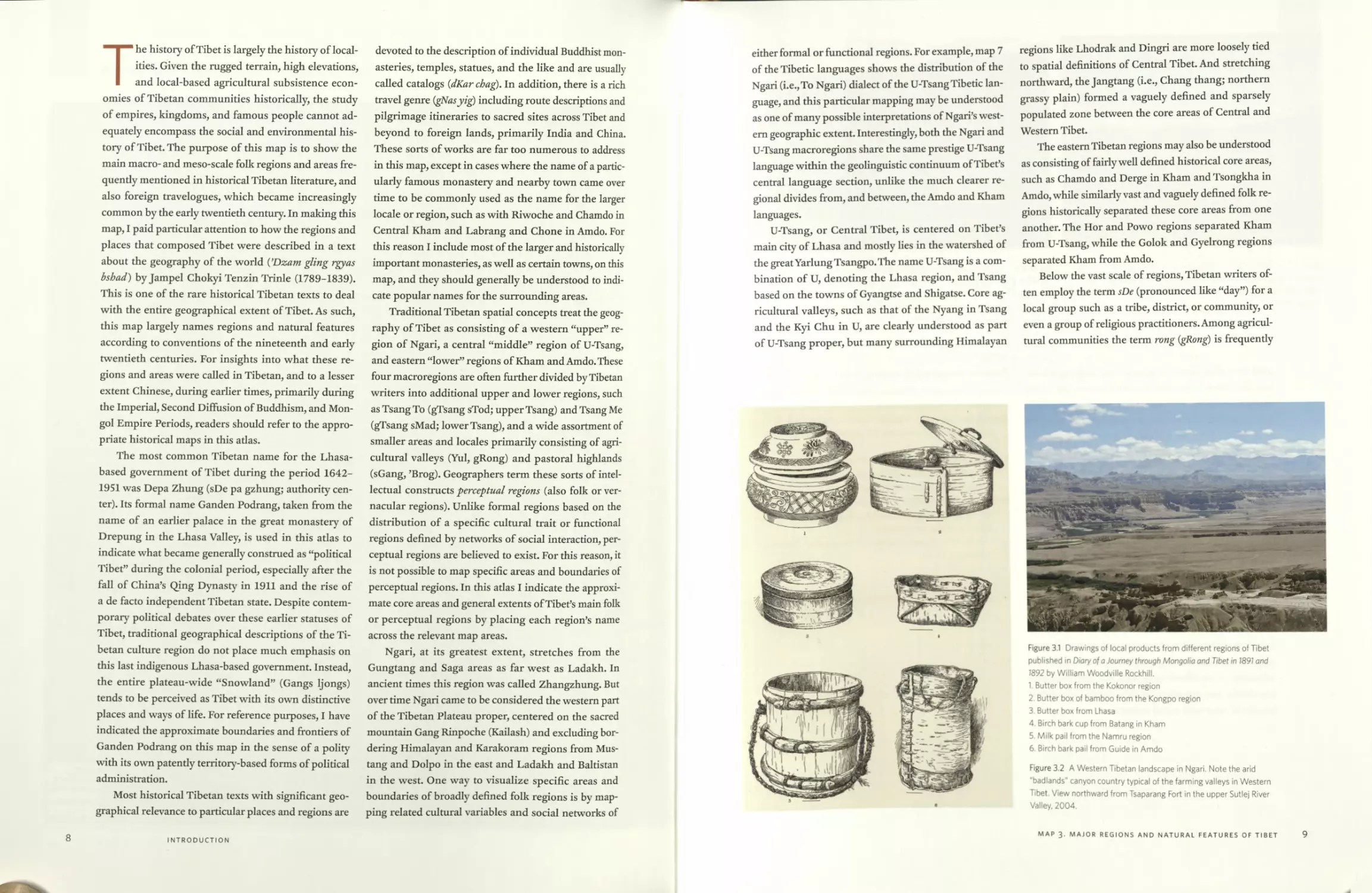
Figure 3.1 Drawings of local products from different regions of Tibet
published in Diary of a Journey through Mongolia and Tibet in 1891 and
1892 by William Woodville Rockhill.
1. Butter box from the Kokonor region
2. Butter box of bamboo from the Kongpo region
3. Butter box from Lhasa
4. Birch bark cup from Batang in Kham
5. Milk pail from the Namru region
6. Birch bark pail from Guide in Amdo
Figure 3.2 A Western Tibetan landscape in Ngari. Note the arid
badlands" canyon country typical of the farming valleys in Western
Tibet. View northward from Tsaparang Fort in the upper Sutlej River
Valley, 2004.
MAP 3. MAJOR REGIONS AND NATURAL FEATURES OF TIBET
9
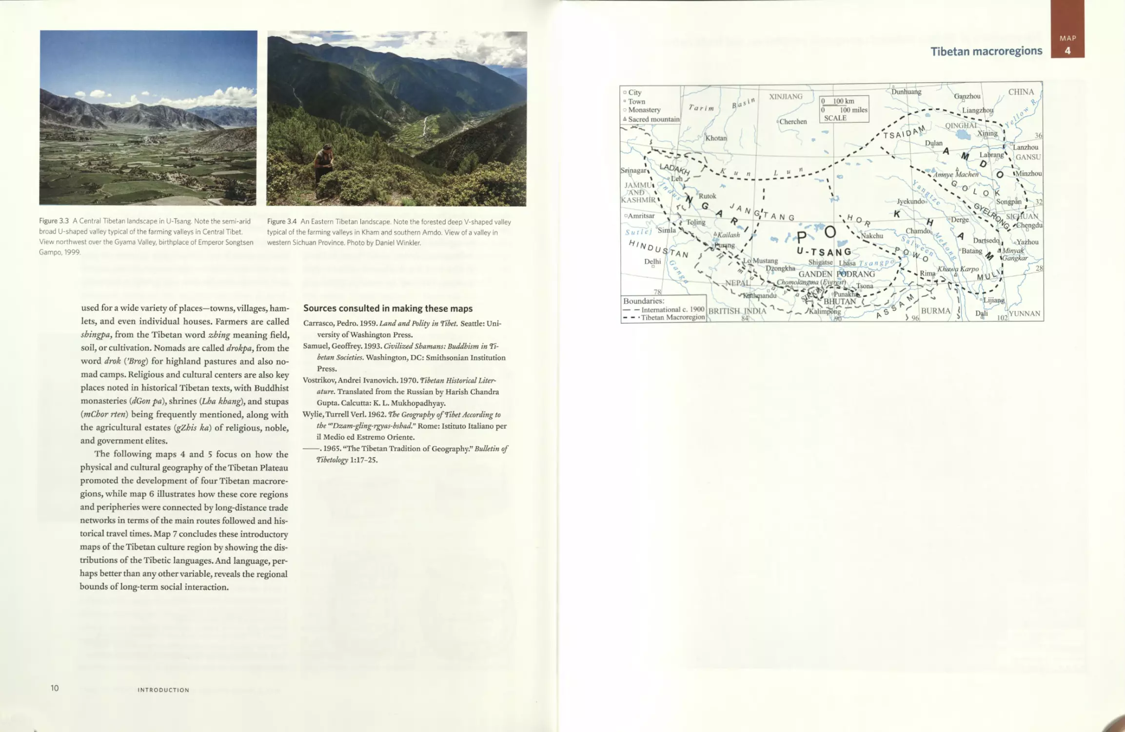
Figure 3.3 A Central Tibetan landscape in U-Tsang. Note the semi-arid
broad U-shaped valley typical of the farming valleys in Central Tibet.
View northwest over the Gyama Valley, birthplace of Emperor Songtsen
Gampo, 1999.
Figure 3.4 An Eastern Tibetan landscape. Note the forested deep V-shaped valley
typical of the farming valleys in Kham and southern Amdo. View of a valley in
western Sichuan Province. Photo by Daniel Winkler.
used for a wide variety of places—towns, villages, ham-
lets, and even individual houses. Farmers are called
shingpa, from the Tibetan word zhing meaning field,
soil, or cultivation. Nomads are called drokpa, from the
word drok ("Brog) for highland pastures and also no-
mad camps. Religious and cultural centers are also key
places noted in historical Tibetan texts, with Buddhist
monasteries (dGon pa), shrines (Lha khang), and stupas
(mChor rteri) being frequendy mentioned, along with
the agricultural estates (gZhis ka) of religious, noble,
and government elites.
The following maps 4 and 5 focus on how the
physical and cultural geography of the Tibetan Plateau
promoted the development of four Tibetan macrore-
gions, while map 6 illustrates how these core regions
and peripheries were connected by long-distance trade
networks in terms of the main routes followed and his-
torical travel times. Map 7 concludes these introductory
maps of the Tibetan culture region by showing the dis-
tributions of the Tibetic languages. And language, per-
haps better than any other variable, reveals the regional
bounds of long-term social interaction.
Sources consulted in making these maps
Carrasco, Pedro. 1959. Land and Polity in Tibet. Seatde: Uni-
versity of Washington Press.
Samuel, Geoffrey. 1993. Civilized Shamans: Buddhism in Ti-
betan Societies. Washington, DC: Smithsonian Institution
Press.
Vostrikov, Andrei Ivanovich. 1970. Tibetan Historical Liter-
ature. Translated from the Russian by Harish Chandra
Gupta. Calcutta: K. L. Mukhopadhyay.
Wylie, Turrell Verl. 1962. The Geography of Tibet According to
the iaDzam-gling-rgyas-bshad.” Rome: Istituto Italiano per
il Medio ed Estremo Oriente.
----. 1965. “The Tibetan Tradition of Geography.” Bulletin of
Tibetology 1:17-25.
10
INTRODUCTION
MAP
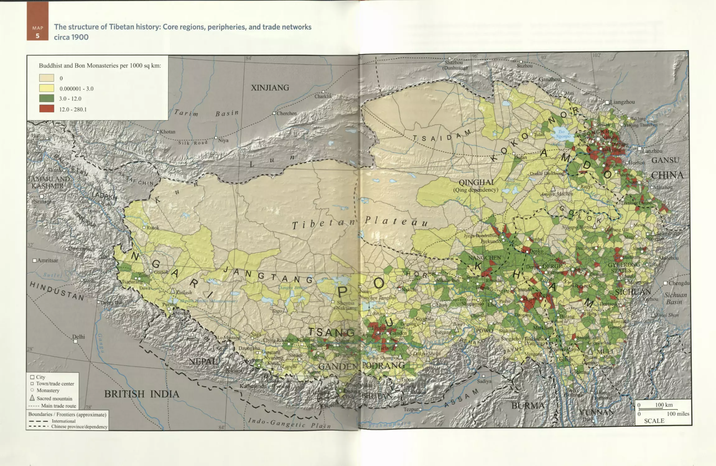
4
Tibetan macroregions
MAP
5
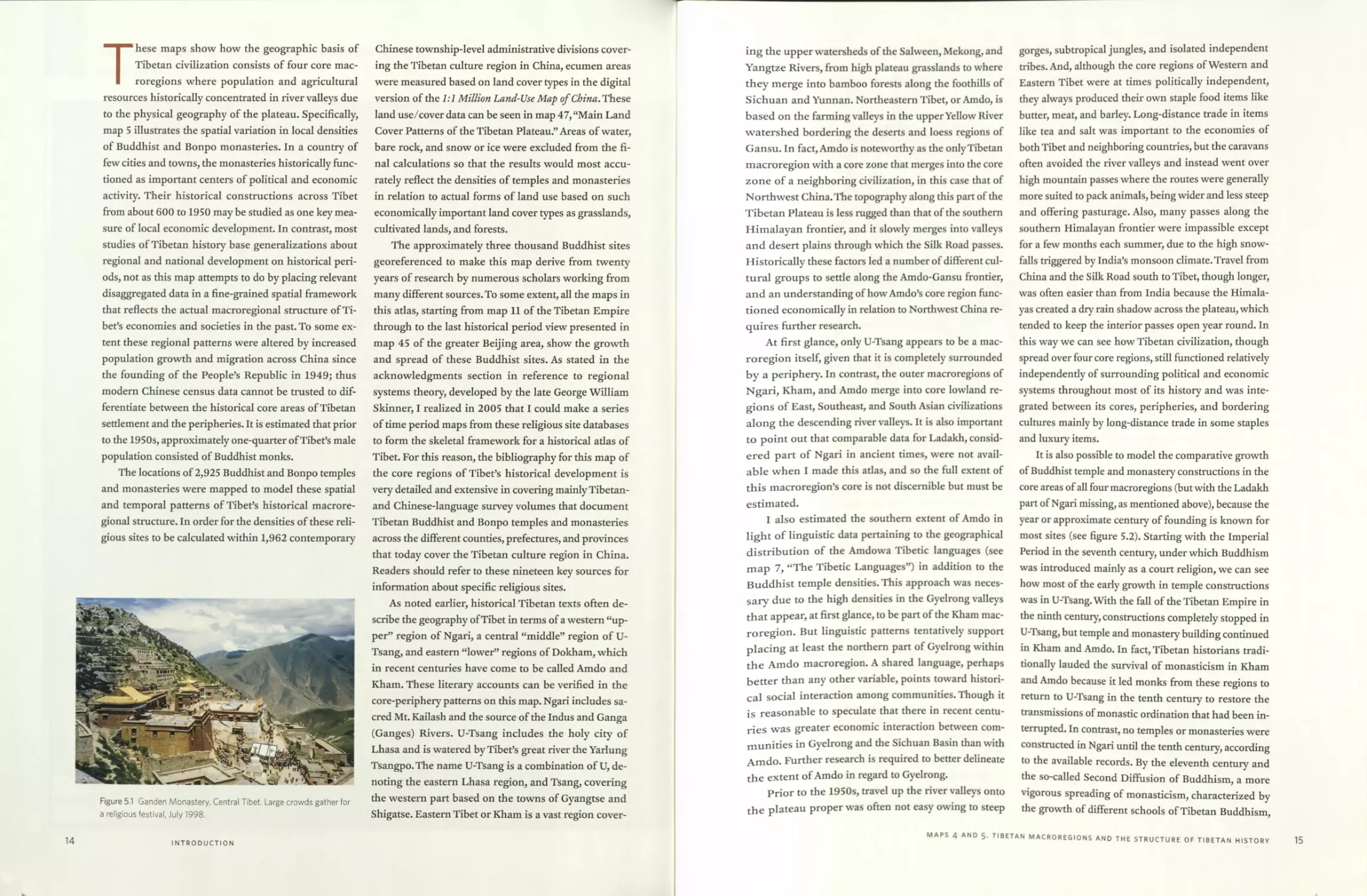
The structure of Tibetan history: Core regions, peripheries, and trade networks
circa 1900
□ Amritsar
v. 5* и 11
Delhi
Charklik'
'Cherchen
Khotan
chin
□ Ri
Ytn
Daw:
BRITISH INDIA
siik'Koia" TNiy*
Buddhist and Bon Monasteries per 1000 sq km:
0
XINJIANG
0.000001 -3.0
3.0- 12.0
12.0-280.1
a r i
Basin
Boundaries / Frontiers (approximate)
— — — International
- - - - • Chinese province/dependency
^^-G a n g e t i c p/^
- Yem
--------____________
□ City
□ Town/trade center
О Monastery
A Sacred mountain
----Main trade route
These maps show how the geographic basis of
Tibetan civilization consists of four core mac-
roregions where population and agricultural
resources historically concentrated in river valleys due
to the physical geography of the plateau. Specifically,
map 5 illustrates the spatial variation in local densities
of Buddhist and Bonpo monasteries. In a country of
few cities and towns, the monasteries historically func-
tioned as important centers of political and economic
activity. Their historical constructions across Tibet
from about 600 to 1950 may be studied as one key mea-
sure of local economic development. In contrast, most
studies of Tibetan history base generalizations about
regional and national development on historical peri-
ods, not as this map attempts to do by placing relevant
disaggregated data in a fine-grained spatial framework
that reflects the actual macroregional structure of Ti-
bet’s economies and societies in the past. To some ex-
tent these regional patterns were altered by increased
population growth and migration across China since
the founding of the People’s Republic in 1949; thus
modern Chinese census data cannot be trusted to dif-
ferentiate between the historical core areas of Tibetan
settlement and the peripheries. It is estimated that prior
to the 1950s, approximately one-quarter of Tibet’s male
population consisted of Buddhist monks.
The locations of 2,925 Buddhist and Bonpo temples
and monasteries were mapped to model these spatial
and temporal patterns of Tibet’s historical macrore-
gional structure. In order for the densities of these reli-
gious sites to be calculated within 1,962 contemporary
Figure 5.1 Ganden Monastery, Central Tibet. Large crowds gather for
a religious festival, July 1998.
Chinese township-level administrative divisions cover-
ing the Tibetan culture region in China, ecumen areas
were measured based on land cover types in the digital
version of the 1:1 Million Land-Use Map of China, These
land use/cover data can be seen in map 47, “Main Land
Cover Patterns of the Tibetan Plateau.” Areas of water,
bare rock, and snow or ice were excluded from the fi-
nal calculations so that the results would most accu-
rately reflect the densities of temples and monasteries
in relation to actual forms of land use based on such
economically important land cover types as grasslands,
cultivated lands, and forests.
The approximately three thousand Buddhist sites
georeferenced to make this map derive from twenty
years of research by numerous scholars working from
many different sources. To some extent, all the maps in
this atlas, starting from map 11 of the Tibetan Empire
through to the last historical period view presented in
map 45 of the greater Beijing area, show the growth
and spread of these Buddhist sites. As stated in the
acknowledgments section in reference to regional
systems theory, developed by the late George William
Skinner, I realized in 2005 that I could make a series
of time period maps from these religious site databases
to form the skeletal framework for a historical atlas of
Tibet. For this reason, the bibliography for this map of
the core regions of Tibet’s historical development is
very detailed and extensive in covering mainly Tibetan-
and Chinese-language survey volumes that document
Tibetan Buddhist and Bonpo temples and monasteries
across the different counties, prefectures, and provinces
that today cover the Tibetan culture region in China.
Readers should refer to these nineteen key sources for
information about specific religious sites.
As noted earlier, historical Tibetan texts often de-
scribe the geography of Tibet in terms of a western “up-
per” region of Ngari, a central “middle” region of U-
Tsang, and eastern “lower” regions of Dokham, which
in recent centuries have come to be called Amdo and
Kham. These literary accounts can be verified in the
core-periphery patterns on this map. Ngari includes sa-
cred Mt. Kailash and the source of the Indus and Ganga
(Ganges) Rivers. U-Tsang includes the holy city of
Lhasa and is watered by Tibet’s great river the Yarlung
Tsangpo. The name U-Tsang is a combination of U, de-
noting the eastern Lhasa region, and Tsang, covering
the western part based on the towns of Gyangtse and
Shigatse. Eastern Tibet or Kham is a vast region cover-
14
INTRODUCTION
ing the upper watersheds of the Salween, Mekong, and
Yangtze Rivers, from high plateau grasslands to where
they merge into bamboo forests along the foothills of
Sichuan and Yunnan. Northeastern Tibet, or Amdo, is
based on the farming valleys in the upper Yellow River
watershed bordering the deserts and loess regions of
Gansu. In fact, Amdo is noteworthy as the only Tibetan
macroregion with a core zone that merges into the core
zone of a neighboring civilization, in this case that of
Northwest China. The topography along this part of the
Tibetan Plateau is less rugged than that of the southern
Himalayan frontier, and it slowly merges into valleys
and desert plains through which the Silk Road passes.
Historically these factors led a number of different cul-
tural groups to setde along the Amdo-Gansu frontier,
and an understanding of how Amdo’s core region func-
tioned economically in relation to Northwest China re-
quires further research.
At first glance, only U-Tsang appears to be a mac-
roregion itself, given that it is completely surrounded
by a periphery. In contrast, the outer macroregions of
Ngari, Kham, and Amdo merge into core lowland re-
gions of East, Southeast, and South Asian civilizations
along the descending river valleys. It is also important
to point out that comparable data for Ladakh, consid-
ered part of Ngari in ancient times, were not avail-
able when I made this adas, and so the full extent of
this macroregion’s core is not discernible but must be
estimated.
I also estimated the southern extent of Amdo in
light of linguistic data pertaining to the geographical
distribution of the Amdowa Tibetic languages (see
map 7, “The Tibetic Languages”) in addition to the
Buddhist temple densities. This approach was neces-
sary due to the high densities in the Gyelrong valleys
that appear, at first glance, to be part of the Kham mac-
roregion. But linguistic patterns tentatively support
placing at least the northern part of Gyelrong within
the Amdo macroregion. A shared language, perhaps
better than any other variable, points toward histori-
cal social interaction among communities. Though it
is reasonable to speculate that there in recent centu-
ries was greater economic interaction between com-
munities in Gyelrong and the Sichuan Basin than with
Amdo. Further research is required to better delineate
the extent of Amdo in regard to Gyelrong.
Prior to the 1950s, travel up the river valleys onto
the plateau proper was often not easy owing to steep
gorges, subtropical jungles, and isolated independent
tribes. And, although the core regions of Western and
Eastern Tibet were at times politically independent,
they always produced their own staple food items like
butter, meat, and barley. Long-distance trade in items
like tea and salt was important to the economies of
both Tibet and neighboring countries, but the caravans
often avoided the river valleys and instead went over
high mountain passes where the routes were generally
more suited to pack animals, being wider and less steep
and offering pasturage. Also, many passes along the
southern Himalayan frontier were impassible except
for a few months each summer, due to the high snow-
falls triggered by India’s monsoon climate. Travel from
China and the Silk Road south to Tibet, though longer,
was often easier than from India because the Himala-
yas created a dry rain shadow across the plateau, which
tended to keep the interior passes open year round. In
this way we can see how Tibetan civilization, though
spread over four core regions, still functioned relatively
independently of surrounding political and economic
systems throughout most of its history and was inte-
grated between its cores, peripheries, and bordering
cultures mainly by long-distance trade in some staples
and luxury items.
It is also possible to model the comparative growth
of Buddhist temple and monastery constructions in the
core areas of all four macroregions (but with the Ladakh
part of Ngari missing, as mentioned above), because the
year or approximate century of founding is known for
most sites (see figure 5.2). Starting with the Imperial
Period in the seventh century, under which Buddhism
was introduced mainly as a court religion, we can see
how most of the early growth in temple constructions
was in U-Tsang. With the fall of the Tibetan Empire in
the ninth century, constructions completely stopped in
U-Tsang, but temple and monastery building continued
in Kham and Amdo. In fact, Tibetan historians tradi-
tionally lauded the survival of monasticism in Kham
and Amdo because it led monks from these regions to
return to U-Tsang in the tenth century to restore the
transmissions of monastic ordination that had been in-
terrupted. In contrast, no temples or monasteries were
constructed in Ngari until the tenth century, according
to the available records. By the eleventh century and
the so-called Second Diffusion of Buddhism, a more
vigorous spreading of monasticism, characterized by
the growth of different schools of Tibetan Buddhism,
MAPS 4 AND 5. TIBETAN MACROREGIONS AND THE STRUCTURE OF TIBETAN HISTORY
15
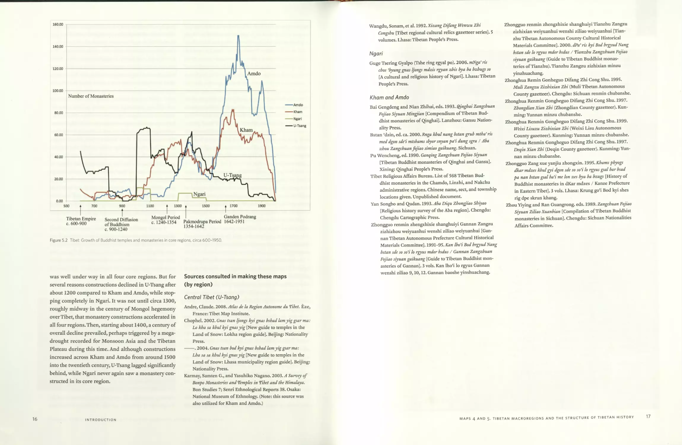
Figure 5.2 Tibet: Growth of Buddhist temples and monasteries in core regions, circa 600-1950.
was well under way in all four core regions. But for
several reasons constructions declined in U-Tsang after
about 1200 compared to Kham and Amdo, while stop-
ping completely in Ngari. It was not until circa 1300,
roughly midway in the century of Mongol hegemony
over Tibet, that monastery constructions accelerated in
all four regions.Then, starting about 1400, a century of
overall decline prevailed, perhaps triggered by a mega-
drought recorded for Monsoon Asia and the Tibetan
Plateau during this time. And although constructions
increased across Kham and Amdo from around 1500
into the twentieth century, U-Tsang lagged significandy
behind, while Ngari never again saw a monastery con-
structed in its core region.
Sources consulted in making these maps
(by region)
Central Tibet (U-Tsang)
Andre, Claude. 2008. Atlas de la Region Autonome du Tibet. Eze,
France: Tibet Map Institute.
Chophel. 2002. Gnas tsan Ijongs kyi gnas bshad lamyiggsarma:
Lo kha sa khul kyi gnasyig [New guide to temples in the
Land of Snow: Lokha region guide]. Beijing: Nationality
Press.
----. 2004. Gnas tsan bod kyi gnas bshad lamyiggsar ma:
Lha sa sa khul kyi gnasyig [New guide to temples in the
Land of Snow: Lhasa municipality region guide]. Beijing:
Nationality Press.
Karmay, Samten G., and Yasuhiko Nagano. 2003. A Survey of
Bonpo Monasteries and Temples in Tibet and the Himalaya.
Bon Studies 7; Senri Ethnological Reports 38. Osaka:
National Museum of Ethnology. (Note: this source was
also utilized for Kham and Amdo.)
16
INTRODUCTION
Wangdu, Sonam, et al. 1992.Xzz«w^ Difang Wenwu Zhi
Congshu [Tibet regional cultural relics gazetteer series]. 5
volumes. Lhasa: Tibetan People’s Press.
Ngari
Guge Tsering Gyalpo (Tshe ring rgyal po). 2006. mNga’ris
chos ’byung gnas Ijongs mdzis rgyan zhis by a ba bzhugs so
[A cultural and religious history of Ngari]. Lhasa: Tibetan
People’s Press.
Kham and Amdo
Bai Gengdeng and Nian Zhihai, eds. 1993. Qinghai Zangchuan
Fojiao Siyuan Mingjian [Compendium of Tibetan Bud-
dhist monasteries of Qinghai]. Lanzhou: Gansu Nation-
ality Press.
Bstan ’dzin, ed. ca. 2000. Rnga khul nang bstan grub mtha’ ris
med dgon sde’i mtshams sbyorsnyan pa’i dung sgra / Aba
zhou Zangchuan fojiao simiao gaikuang. Sichuan.
Pu Wencheng, ed. 1990. Ganqing Zangchuan Fojiao Siyuan
[Tibetan Buddhist monasteries of Qinghai and Gansu].
Xining: Qinghai People’s Press.
Tibet Religious Affairs Bureau. List of 568 Tibetan Bud-
dhist monasteries in the Chamdo, Linzhi, and Nakchu
administrative regions. Chinese name, sect, and township
locations given. Unpublished document.
Yan Songbo and Qudan. 1993. Aba Diqu Zhongjiao Shiyao
[Religious history survey of the Aba region]. Chengdu:
Chengdu Cartographic Press.
Zhongguo renmin zhengzhixie shanghuiyi Garman Zangzu
zizhizhou weiyuanhui wenshi ziliao weiyuanhui [Gan-
nan Tibetan Autonomous Prefecture Cultural Historical
Materials Committee]. 1991-95. Kan Iho’i Bod brgyud Nang
bstan sde so so’i lo rgyus mdor bsdus / Gannan Zangzhuan
Fojiao siyuan gaikuang [Guide to Tibetan Buddhist mon-
asteries of Gannan]. 3 vols. Kan Iho’i lo rgyus Gannan
wenshi ziliao 9,10,12. Gannan baoshe yinshuachang.
Zhongguo renmin zhengzhixie shanghuiyi Tianzhu Zangzu
zizhixian weiyuanhui wenshi ziliao weiyuanhui [Tian-
zhu Tibetan Autonomous County Cultural Historical
Materials Committee]. 2000. dPa’ ris kyi Bod brgyud Nang
bstan sde lo rgyus mdor bsdus / Tianzhu Zangzhuan Fojiao
siyuan gaikuang (Guide to Tibetan Buddhist monas-
teries of Tianzhu). Tianzhu Zangzu zizhixian minzu
yinzhuachang.
Zhonghua Remin Gonheguo Difang Zhi Cong Shu. 1995.
Muli Zangzu Zizhixian Zhi (Muli Tibetan Autonomous
County gazetteer). Chengdu: Sichuan renmin chubanshe.
Zhonghua Renmin Gongheguo Difang Zhi Cong Shu. 1997.
Zhongdian Xian Zhi (Zhongdian County gazetteer). Kun-
ming: Yunnan minzu chubanshe.
Zhonghua Renmin Gongheguo Difang Zhi Cong Shu. 1999.
Weixi Lisuzu Zizhixian Zhi (Weixi Lisu Autonomous
County gazetteer). Kunming: Yunnan minzu chubanshe.
Zhonghua Renmin Gongheguo Difang Zhi Cong Shu. 1997.
Deqin Xian Zhi (Deqin County gazetteer). Kunming: Yun-
nan minzu chubanshe.
Zhongguo Zang xue yanjiu zhongxin. 1995. Khams phyogs
dkar mdzes khul gyi dgon sde so so’i lo rgyus gsal bar bsad
pa nan bstan gsal ba’i me Ion zes bya ba bzugs [History of
Buddhist monasteries in dKar mdzes / Kanze Prefecture
in Eastern Tibet]. 3 vols. Lhasa: Krung go’i Bod kyi shes
rig dpe skrun khang.
Zhou Yiying and Ran Guangrong. eds. 1989. Zangchuan Fojiao
Siyuan Ziliao Xuanbian [Compilation of Tibetan Buddhist
monasteries in Sichuan]. Chengdu: Sichuan Nationalities
Affairs Committee.
MAPS 4 AND 5. TIBETAN MACROREGIONS AND THE STRUCTURE OF TIBETAN HISTORY
17
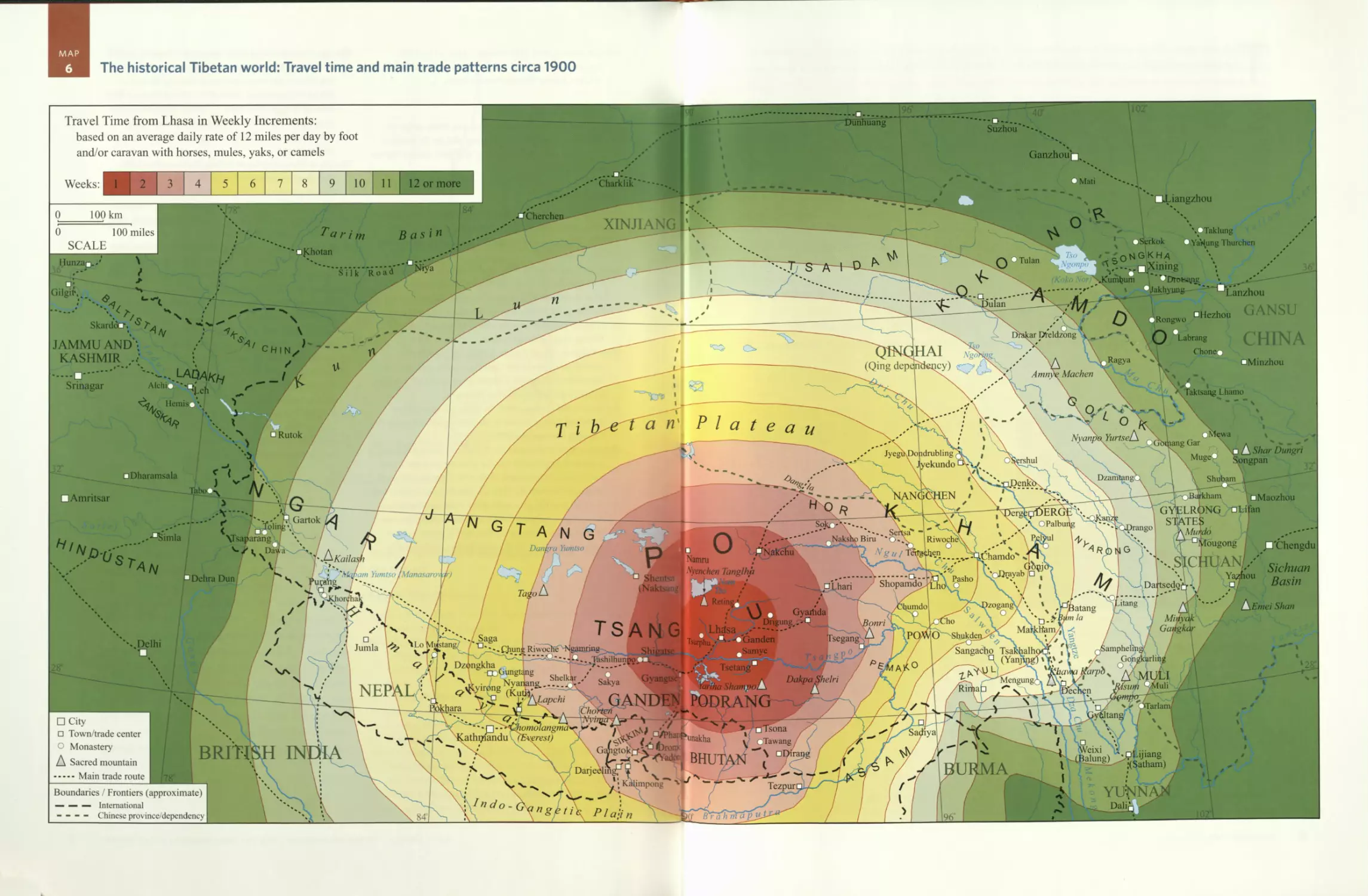
The historical Tibetan world: Travel time and main trade patterns circa 1900
MAP
This map shows the distances that travelers,such
as traders and pilgrims, covered in weekly incre-
ments by either walking or riding along routes
radiating outward from Lhasa to an outer mapped limit
of three months. Traditional forms of travel persisted
in Tibet well into the mid-twentieth century, because
the first roads for motorized vehicles were not built
until the 1950s. Previously it had taken about three
months for travelers from oudying parts of the Tibetan
Plateau, such as the Amdo frontier in Gansu Province,
the foothills along the Sichuan Basin, and Ladakh in
western Tibet, to reach Lhasa. It is important to real-
ize, however, that elite travelers such as government
officials and couriers often made much better time due
to the fresh horses and supplies they could obtain at
official stations along the main routes. Without such
support, the average traveler made about twelve miles
a day, whether walking or riding, because the pack ani-
mals needed to spend roughly half of each day grazing
to meet their nutritional requirements if grain was not
directly fed to them. And in the eastern Himalayas, in
parts of Powo and Zayul, and all through the jungle
regions bordering on the plains of Assam, many routes
were not passable by pack animals, and porters often
made five miles a day at best. The most common pack
animals were horses, mules, and yaks, with the mules
favored due to their ability to go farther on smaller
amounts of food. Indeed, much of the bulk tea carried
to Tibet from China on yaks was frequently transferred
among the herds of different nomadic groups so the
animals would not tire and become useless after about
one week when used in this manner. Bactrian cam-
els were sometimes used too in the northern Tibetan
regions of Amdo and Ladakh, which are closer to the
Central Asian Silk Road routes, where camels are still
widely used as pack animals.
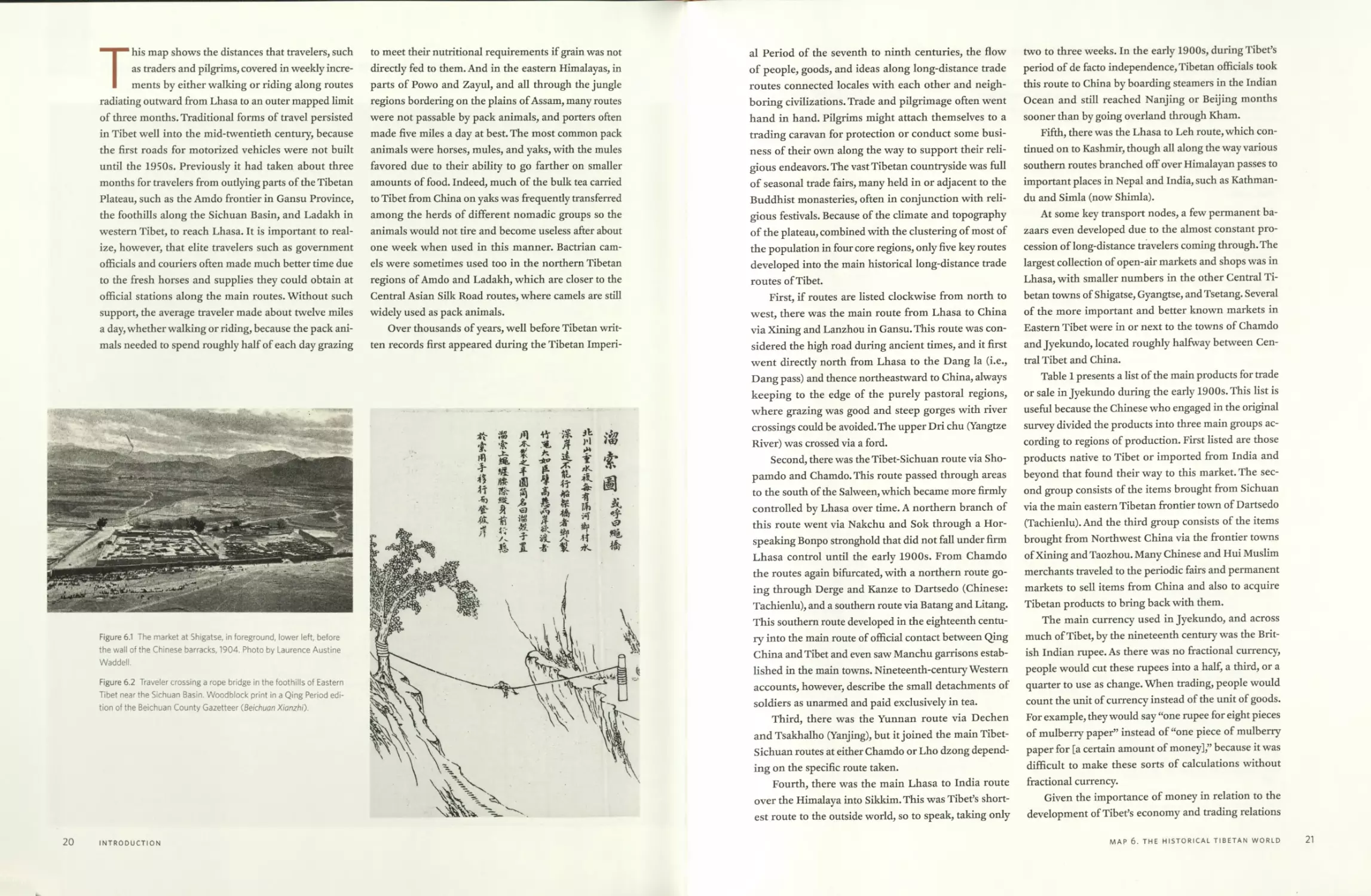
Over thousands of years, well before Tibetan writ-
ten records first appeared during the Tibetan Imperi-
Figure 6.1 The market at Shigatse, in foreground, lower left, before
the wall of the Chinese barracks, 1904. Photo by Laurence Austine
Waddell.
Figure 6.2 Traveler crossing a rope bridge in the foothills of Eastern
Tibet near the Sichuan Basin. Woodblock print in a Qing Period edi-
tion of the Beichuan County Gazetteer (Beichuan Xianzhi).
20
INTRODUCTION
al Period of the seventh to ninth centuries, the flow
of people, goods, and ideas along long-distance trade
routes connected locales with each other and neigh-
boring civilizations. Trade and pilgrimage often went
hand in hand. Pilgrims might attach themselves to a
trading caravan for protection or conduct some busi-
ness of their own along the way to support their reli-
gious endeavors. The vast Tibetan countryside was full
of seasonal trade fairs, many held in or adjacent to the
Buddhist monasteries, often in conjunction with reli-
gious festivals. Because of the climate and topography
of the plateau, combined with the clustering of most of
the population in four core regions, only five key routes
developed into the main historical long-distance trade
routes of Tibet.
First, if routes are listed clockwise from north to
west, there was the main route from Lhasa to China
via Xining and Lanzhou in Gansu. This route was con-
sidered the high road during ancient times, and it first
went directly north from Lhasa to the Dang la (i.e.,
Dang pass) and thence northeastward to China, always
keeping to the edge of the purely pastoral regions,
where grazing was good and steep gorges with river
crossings could be avoided. The upper Dri chu (Yangtze
River) was crossed via a ford.
Second, there was the Tibet-Sichuan route via Sho-
pamdo and Chamdo. This route passed through areas
to the south of the Salween, which became more firmly
controlled by Lhasa over time. A northern branch of
this route went via Nakchu and Sok through a Hor-
speaking Bonpo stronghold that did not fall under firm
Lhasa control until the early 1900s. From Chamdo
the routes again bifurcated, with a northern route go-
ing through Derge and Kanze to Dartsedo (Chinese:
Tachienlu), and a southern route via Batang and Litang.
This southern route developed in the eighteenth centu-
ry into the main route of official contact between Qing
China and Tibet and even saw Manchu garrisons estab-
lished in the main towns. Nineteenth-century Western
accounts, however, describe the small detachments of
soldiers as unarmed and paid exclusively in tea.
Third, there was the Yunnan route via Dechen
and Tsakhalho (Yanjing), but it joined the main Tibet-
Sichuan routes at either Chamdo or Lho dzong depend-
ing on the specific route taken.
Fourth, there was the main Lhasa to India route
over the Himalaya into Sikkim. This was Tibet’s short-
est route to the outside world, so to speak, taking only
two to three weeks. In the early 1900s, during Tibet’s
period of de facto independence, Tibetan officials took
this route to China by boarding steamers in the Indian
Ocean and still reached Nanjing or Beijing months
sooner than by going overland through Kham.
Fifth, there was the Lhasa to Leh route, which con-
tinued on to Kashmir, though all along the way various
southern routes branched off over Himalayan passes to
important places in Nepal and India, such as Kathman-
du and Simla (now Shimla).
At some key transport nodes, a few permanent ba-
zaars even developed due to the almost constant pro-
cession of long-distance travelers coming through. The
largest collection of open-air markets and shops was in
Lhasa, with smaller numbers in the other Central Ti-
betan towns of Shigatse, Gyangtse, and Tsetang. Several
of the more important and better known markets in
Eastern Tibet were in or next to the towns of Chamdo
and Jyekundo, located roughly halfway between Cen-
tral Tibet and China.
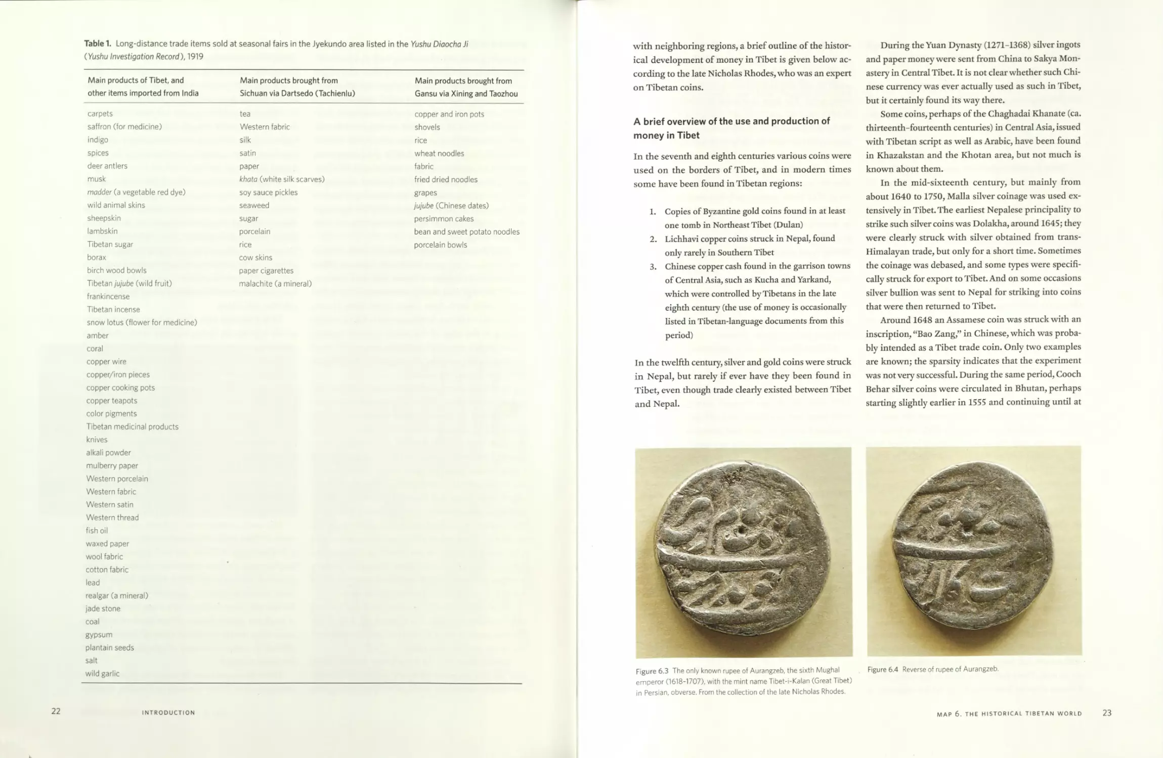
Table 1 presents a list of the main products for trade
or sale in Jyekundo during the early 1900s. This list is
useful because the Chinese who engaged in the original
survey divided the products into three main groups ac-
cording to regions of production. First listed are those
products native to Tibet or imported from India and
beyond that found their way to this market. The sec-
ond group consists of the items brought from Sichuan
via the main eastern Tibetan frontier town of Dartsedo
(Tachienlu). And the third group consists of the items
brought from Northwest China via the frontier towns
of Xining and Taozhou. Many Chinese and Hui Muslim
merchants traveled to the periodic fairs and permanent
markets to sell items from China and also to acquire
Tibetan products to bring back with them.
The main currency used in Jyekundo, and across
much of Tibet, by the nineteenth century was the Brit-
ish Indian rupee. As there was no fractional currency,
people would cut these rupees into a half, a third, or a
quarter to use as change. When trading, people would
count the unit of currency instead of the unit of goods.
For example, they would say “one rupee for eight pieces
of mulberry paper” instead of “one piece of mulberry
paper for [a certain amount of money],” because it was
difficult to make these sorts of calculations without
fractional currency.
Given the importance of money in relation to the
development of Tibet’s economy and trading relations
MAP 6. THE HISTORICAL TIBETAN WORLD
21
Table 1. Long-distance trade items sold at seasonal fairs in the Jyekundo area listed in the Yushu Diaocha Ji
(Yushu Investigation Record), 1919
Main products of Tibet, and Main products brought from Main products brought from
other items imported from India Sichuan via Dartsedo (Tachienlu) Gansu via Xining and Taozhou
carpets tea copper and iron pots
saffron (for medicine) Western fabric shovels
indigo silk rice
spices satin wheat noodles
deer antlers paper fabric
musk khata (white silk scarves) fried dried noodles
madder (a vegetable red dye) soy sauce pickles grapes
wild animal skins seaweed jujube (Chinese dates)
sheepskin sugar persimmon cakes
lambskin porcelain bean and sweet potato noodles
Tibetan sugar rice porcelain bowls
borax cow skins
birch wood bowls paper cigarettes
Tibetan jujube (wild fruit) malachite (a mineral)
frankincense
Tibetan incense
snow lotus (flower for medicine)
amber
coral
copper wire
copper/iron pieces
copper cooking pots
copper teapots
color pigments
Tibetan medicinal products
knives
alkali powder
mulberry paper
Western porcelain
Western fabric
Western satin
Western thread
fish oil
waxed paper
wool fabric
cotton fabric
lead
realgar (a mineral)
jade stone
coal
gypsum
plantain seeds
salt
wild garlic
22
INTRODUCTION
with neighboring regions, a brief outline of the histor-
ical development of money in Tibet is given below ac-
cording to the late Nicholas Rhodes, who was an expert
on Tibetan coins.
A brief overview of the use and production of
money in Tibet
In the seventh and eighth centuries various coins were
used on the borders of Tibet, and in modern times
some have been found in Tibetan regions:
1. Copies of Byzantine gold coins found in at least
one tomb in Northeast Tibet (Dulan)
2. Lichhavi copper coins struck in Nepal, found
only rarely in Southern Tibet
3. Chinese copper cash found in the garrison towns
of Central Asia, such as Kucha and Yarkand,
which were controlled by Tibetans in the late
eighth century (the use of money is occasionally
listed in Tibetan-language documents from this
period)
In the twelfth century, silver and gold coins were struck
in Nepal, but rarely if ever have they been found in
Tibet, even though trade clearly existed between Tibet
and Nepal.
During the Yuan Dynasty (1271-1368) silver ingots
and paper money were sent from China to Sakya Mon-
astery in Central Tibet. It is not clear whether such Chi-
nese currency was ever actually used as such in Tibet,
but it certainly found its way there.
Some coins, perhaps of the Chaghadai Khanate (ca.
thirteenth-fourteenth centuries) in Central Asia, issued
with Tibetan script as well as Arabic, have been found
in Khazakstan and the Khotan area, but not much is
known about them.
In the mid-sixteenth century, but mainly from
about 1640 to 1750, Malla silver coinage was used ex-
tensively in Tibet. The earliest Nepalese principality to
strike such silver coins was Dolakha, around 1645; they
were clearly struck with silver obtained from trans-
Himalayan trade, but only for a short time. Sometimes
the coinage was debased, and some types were specifi-
cally struck for export to Tibet. And on some occasions
silver bullion was sent to Nepal for striking into coins
that were then returned to Tibet.
Around 1648 an Assamese coin was struck with an
inscription, “Bao Zang,” in Chinese, which was proba-
bly intended as a Tibet trade coin. Only two examples
are known; the sparsity indicates that the experiment
was not very successful. During the same period, Cooch
Behar silver coins were circulated in Bhutan, perhaps
starting slightly earlier in 1555 and continuing until at
Figure 6.4 Reverse of rupee of Aurangzeb.
Figure 6.3 The only known rupee of Aurangzeb, the sixth Mughal
emperor (1618-1707), with the mint name Tibet-i-Kalan (Great Tibet)
in Persian, obverse. From the collection of the late Nicholas Rhodes.
MAP 6. THE HISTORICAL TIBETAN WORLD
23
least around 1800. And again silver was sent to Cooch
Behar for return as coins to Bhutan. Such coins are
sometimes found in Tibet.
In the eighth year of Aurangzeb (1666), the sixth
Mughal emperor, gold and silver coins were struck
with the mint name Tibet-i-Kalan (Great Tibet) to cele-
brate his conquest of Ladakh. But these coins are rarely
found; the only known example is shown here (figs. 6.3
and 6.4).
From the early eighteenth century until 1813, silver
coinage struck in Garhwal was used in the Western Ti-
betan wool trade. Coins of similar standard, and initial-
ly of similar design, were struck from circa 1770 until
1842 in Ladakh and were similarly used in Western
Tibet. Such coins—both Ladakhi and Garhwali—are
found as far east as Kalimpong.
The first coins of Tibet itself were silver tangkas
struck by the regent, the Demo Tulku, in 1763. These
were followed by rare gold and silver coins in 1785 by
the eighth Dalai Lama. The Tibetan government con-
tinued to mint silver coins in 1791-93 and on various
occasions in the nineteenth century. Most coins were
struck in Lhasa, but some in Kongpo to the east. Pro-
duction of such silver coins (debased) increased sub-
stantially around 1875; they were struck in large num-
bers in Lhasa from then until 1921, and again in 1925
and 1929-30.
The first experimental silver coins in the name of
Emperor Qianlong were struck in 1792, but in the Ti-
betan script only. These were followed by coins with
bilingual inscriptions (Chinese and Tibetan) in 1792-
1801,1819-24, and 1835-36. In 1801 a few coins were
also struck with Manchu writing. After 1836, no more
such Sino-Tibetan coins were struck until 1910.
British Indian rupees found their way into Tibet af-
ter about 1840 and were used in large numbers from
the 1880s on to buy tea from China. These rupees be-
came widely used as a main form of currency across
Kham. When the supply of rupees was reduced after
1902, copies of Victorian rupees were made in the
mints of Sichuan for circulation in Kham until the
1930s, though they were increasingly debased after
1912.
In early 1910, when the thirteenth Dalai Lama re-
turned from China, the first silver and copper coins
with a snow lion design were struck in Tibet in Tibetan
script only. These coins continued in the name of the
Chinese emperor Xuantong (Puyi; the last emperor) in
1910 after the Chinese military takeover of the coun-
try. More silver and copper coins, initially with Tibetan
motifs and script, were struck from 1913 on, and then
with Chinese dragon types and in both Chinese and Ti-
betan script. The snow lion coins in silver were struck
in 1913-19,1922, and 1924-27, and in copper in 1913-
28,1932-38, and 1946-53. Silver coins with increased
denominations were struck in 1933-38 and 1946. Very
debased silver coins were struck from 1947 to 1952.
The first Tibetan banknotes were printed in Lhasa
after the return of the thirteenth Dalai Lama from In-
dia in 1912. These notes initially had fixed dates of 1912
and 1913, were single color, and were issued until 1926
in limited numbers. Then multicolored notes were
printed from 1926 until 1941 to make forgery harder.
Further types and denominations of paper money were
issued by the Tibetan government until 1959, when the
fourteenth Dalai Lama fled to India.
Some paper money in the Tibetan script was issued
in Chinese-controlled parts of Kham incorporated into
the short-lived Xikang Province from the 1920s to the
1940s for use by Tibetan speakers.
Chinese silver coins were particularly used in eth-
nic Tibetan parts of Yunnan Province.
Yuan Shikai silver dollars were restruck by the Chi-
nese in the 1950s to pay Tibetan road builders. After
1959, only the Chinese renminbi currency was used
(both paper and aluminum). And with goods extensive-
ly rationed during the early PRC period, Chinese paper
ration coupons were often the only useful currency.
Sources consulted in making this map
Chokyi Gyasto, Katok Situ III (1880-1925). Y372.Dbus gtsang
gi gnasyig: An Account of a Pilgrimage to Central Tibet
during the Years 1918 to 1920, Being the text Gangs Ijongs
dbus gtsang gnas bskorlamyig norbu zla shel gyi se mo
do. TBRC W9668. Palampur, India: Sungrab Nyamso
Gyunphel Parkhang.
Rhodes, Nicholas. 2000. “The Monetisation of Bhutan.” Jour-
nal of Bhutan Studies 2(2):79-95.
Teichman, Eric. 1922. Travels of a Consular Officer in Eastern
Tibet: Together with a History of the Relations between
China, Tibet and India. Cambridge: Cambridge University
Press. Route itinerary with distances and dates listed in
appendix.
Tucci, Giuseppe. 1935. Secrets of Tibet: Being the Chronicle of
the Tucci Scientific Expedition to Western Tibet (1933) by
Dr. Giuseppe Tucci and Captain E. Ghersi. Translated from
Italian by Mary A. Johnstone. London: Blackie & Son.
24
INTRODUCTION
Walsh, Ernest Herbert Cooper. 1907. The Coinage of Tibet.
Calcutta: Baptist Mission Press.
Younghusband, Francis Edward. 1926. Peking to Lhasa: The
Narrative of journeys in the Chinese Empire Made by the
Late Brigadier-General George Pereira. Compiled from notes
and diaries supplied by Major-General Sir Cecil Pereira.
Boston: Houghton.
Zhou, Xiwu. Yusbu diao cha ji. Original Yushu tu si diao cha ji,
1919; repr.Taibei: Cheng wen chu ban she, 1968.
MAP 6. THE HISTORICAL TIBETAN WORLD
25
MAP
7
The Tibetic languages
NICOLAS TOURNADRE AND KARL RYAVEC
□ Kashgar
Yarkand
iCherchen
inmg
Niya
Rebl
ZAN'
iOLOK
32 PA К
I Gar
Laste
KANI
KHYUNGPtP
Tsanda
Nakchu
RONGDRAK
Nyagrongi
:ham
Xjangkars
PHENPQ
KONGPO
Unci
CHAKTREI
6
KathmanduD
DUR
Chomblapt
(Everest)
Dartsedoq
MINYAK'
О Mao Xi An
xtion
Gangchen Dzonga \
(Kanchenjunga} z
( DHROMCL
' SHARKHOK -v
Zungchu BAIMA /
ZHONGU
YUSHU \ „
□ \ z- П -
JyekundoSershul
Amnve MachenA
s ______ □
Machen
BATANG \n
° A* MTANG
M,nx j,
□Dunhuang
96°
ч *>ч «^hangyeQ
TAJIKISTAN
XINJIANG
North-Eastern section
AFG.
Themchel
Khotan
; 3£
Lanzhou
lagormo
Min Xian
KH<
aRutok
South-Eastern section
Boundary in Dispute
TIBET\AUTONOMOUS REGION
HOR BACHEN
HOR NAKCHU
Shim la
□ Chengdu
INDIA
HU AN
Syenchen Thanglfa —
Shan
Central section
\UTTAR PRADESH
BIHAR
_>Tsetang
LHOKHA
□Nyima
Dangra Yumtso
Political Boundaries (circa 2000):
—" “ — International (both de jure and de facto)
----------Chinese Province/Autonom. Region, Indian State
--------Approximate Boundaries of
Geolinguistic Sections
These boundaries, some overlapping, also
indicate the extents of those languages that
cover large areas in China (i.e. U-Tsang, Amdo,
Hor and Kham). Dialects are mapped in these
three main regions.
A* Pockets of Amdo spoken
K* Pockets of Kham spoken
□ Large City
□ Small City/Town
Language data according to:
The Tibetic Languages
by Nicolas Toumadre and Hiroyuki Suzuki
r □
Jiuquan
QINGHAI
" □
--Dulan
y* VHUMLA’K
7 J oxPOLPa
k .. Junila \
“<щф-Western section-"x
102° INNER MONGOLIA У
. AUTONOMOUS REGION f
r ?/ / i ‘
lung/-3 i
)j£PE / jVQ _____ -«W- JUL»
Thimf MERA ‘ Z
DZONGKHaJC^’*'--------
bh ('ГГ\ л
Southern section ASSAM
11 <^zSadiya\
LHOKE f^rjcciing'
L /)/WEST BENI
>rN!NGXIA
Lhari PEMBAR
□
0 100 miles
SCALE
Purane
AND У? I
f CHINA
IWuwei Xх
A Kailash , —,
) Марат ftimtso (Maniisciro ar)
TO NGARI
^AU^Yr^bpyGCHU
:org^
\
nJ
0 Tso jL
Ngonpol
BANAKq TSONI
Chabcha^-,. -
\
□Gertse |
K2-
ГGANSU
UiPrSig 1 S 4
у n
Charklik
Elevation:
snow/glacier
---up to 8848 m.
---up to 4400 m.
---up to 2750 m.
100 km
.'Slp<N
iSkardux BALTI
' N »*' \ I * X *1
\North-Western section 7
rT ?>?SHAMSKAi: 1 I
~\PURIK ladakhi/'^j
LMiaagU.
О ^purikn^adake
- flaJ.
SKARI ,
HMIRNh
Padum IУ
KEI
^**i~~<©hai£1ba7>LAHULI
□ Amritsar\ Н1МАСНЛ1 \
• PRADESH \
PUNJAB
4KZ.UINLVMVI N • Gvclt;
KHAM
к ЛГ1 UK \ Balling
zNDDelnal)un
> HARYANA.'"
Hunza \
' O ^/5
-- Northern J
GileitXn- Areas---U
The “Tibetic” languages belong to the Sino-
Tibetan macrofamily. They correspond to a
well-defined family of languages derived from
Old Tibetan, although in some rare cases such as Baima
or Khalong, a Qiangic substratum is a very probable
hypothesis. The language called Old Tibetan was spo-
ken at the time of the Tibetan Empire (seventh to ninth
centuries). Old Tibetan is very similar to the classical
literary language, which has preserved a very archaic
orthography. And indeed, all the modern languages not
only have regular reflexes of Classical Literary Tibetan
but also share a core vocabulary and grammar.
The Tibetic linguistic family is comparable in size
and diversity to the Romance and Germanic families.
The diversity is due to many factors—geographic, soci-
olinguistic, religious, and political.
The Tibetic family includes languages from five
countries—China, Pakistan, India, Bhutan, and Nepal.
Additionally, Sangdam, a Khams dialect, is spoken in
the Kachin state of Myanmar (Burma). The total num-
ber of Tibetic-language speakers is roughly six million;
this figure is approximate since there is no precise and
reliable census.
Figure 7.1 The Tibetan minister Thonmi Sambhota
’ Thon mi sam b+ho ta), credited by tradition with inventing
the Tibetan alphabet in the seventh century. Circa seventeenth-
century mural in the Potala Palace in Lhasa.
Table 2. The Tibetic Languages
China U-Tsang Khams (няя-^ ), Hor Amdo Kyirong -я^), Zhongu (г^я^Х Khalong gSerpa Zitsadegu dPalskyid / Chos-rje Sharkhok (^^), Thewo (§^5), Chone Drugchu Baima (г^-^-я^-).
Pakistan Balti (qan^^)2
India Purik and Ladakhi («ту^'я^'Х Zangskari Spiti and Lahuli or Gharsha (ир^-я^•), Nyamkat (^яя^) and Jad or Dzad Drengjong language often locally called Lhoke (^5 ).
Nepal Humla Mugu (^-oyrg^X Dolpo (^ч-гй-яруХ Loke or Mustang Nubri (^q-aS^X Tsum (^я-g^), Langtang (weqifiX Yolmo Gyalsumdo Jirel (e ^я^), Sherpa (^-«йя^-) also locally called Sharwi Tamnye (/рй-чр?я-^-Х Kagate also called Shupa Цчучйя^-Х Lhomi (^айя^), Walung (<ц-д^5<;-»(-яй-я^-^я-ц-дс-я|^), and Tokpe Gola
Bhutan Dzongkha (gt-я ), Tsamang (ужц-) or Ch’ocha-ngacha Lakha (<ч-гч) also called Tshangkha (afc^X Dur Brokkat also called Bjokha in Dzongkha, Mera Sakteng Brokpa-ke
1. Sun (2003) uses Chos-rje, but according to Suzuki (p.c.), dPalskyid is better suited to refer to a group of four dialects that include Chos-rje.
2. Balti is traditionally written sbal-ti in Tibetan, but Balti people write it and pronounce it bal-ti.
28
INTRODUCTION
Table 2 lists nearly fifty Tibetic languages, all de-
rived from Old Tibetan. The dialects and varieties cer-
tainly number more than two hundred. The languages
listed can be grouped together at a higher level into
eight major sections, which appear on the map: North-
Western, Western, Central, South-Western, Southern,
South-Eastern, Eastern, and North-Eastern. Each sec-
tion constitutes a geolinguistic continuum.
The data presented here will appear in a forthcom-
ing book, The Tibetic Languages, by Nicolas Tournadre
and Hiroyuki Suzuki (with the collaboration of Kon-
chok Gyatso and Xavier Becker).
The classification reflected in the map is essentially
based on a genetic approach, but it also includes geo-
graphical parameters, migration, and language contact
factors. Non-Tibetic languages such as Gyalrongic,
Qiangic, Mongolic, Turkic, Chinese, et cetera do not
appear on the map.
MAP 7. THE TIBETIC LANGUAGES
29
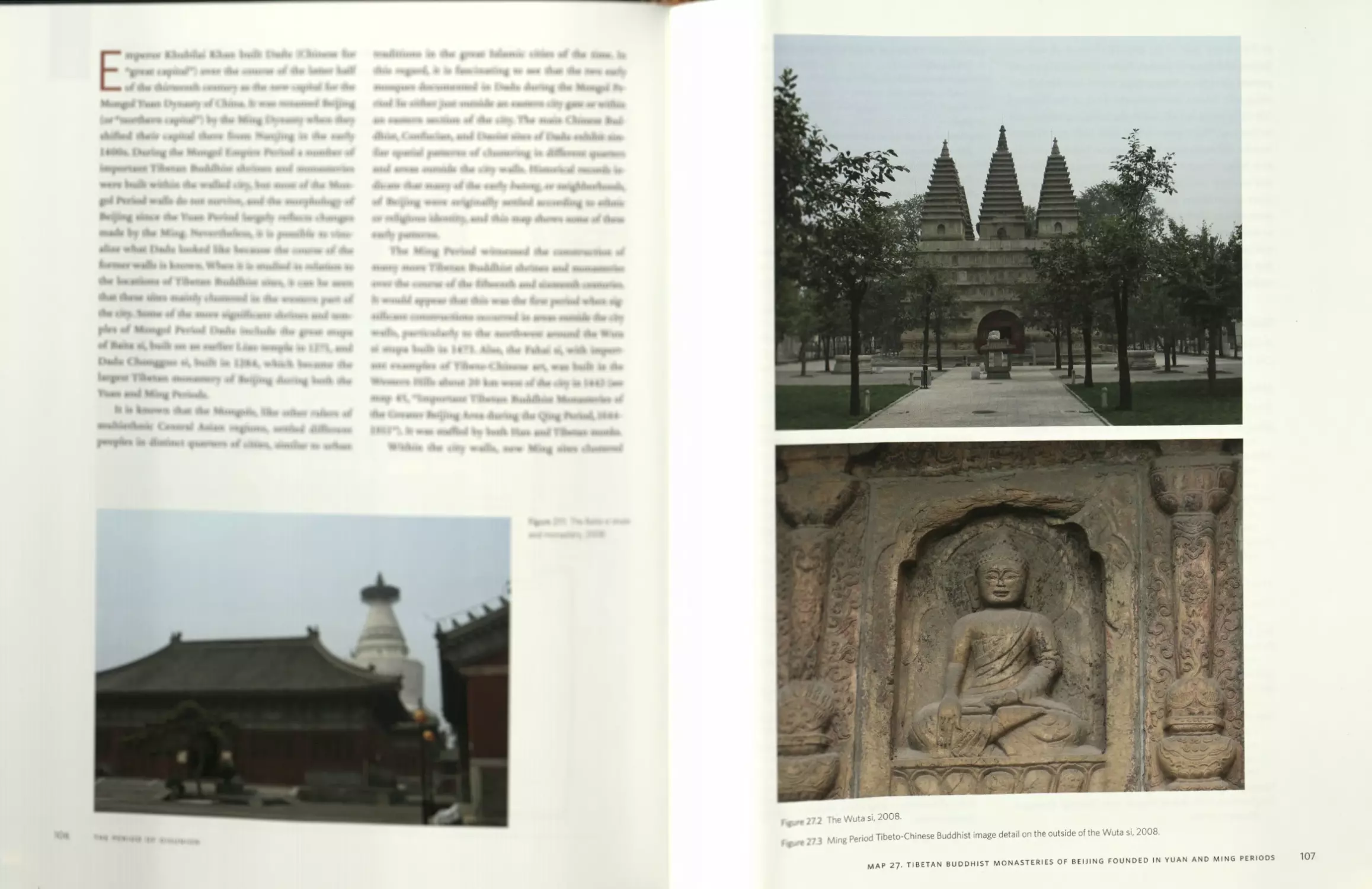
MAP
8
How to use this atlas: Map coverage and cartographic conventions
A series of standardized cartographic symbols
and fonts are used in this atlas (refer to this
map’s legend), such as circles for religious
sites and set ranges of colored elevation zones, so that
historical, social, and cultural patterns can be made
as clear as possible across the maps. This map itself
presents the way the entire Tibetan culture region is
depicted on the main historical period maps through-
out this atlas. Also shown are the map footprints of the
regional-scale maps of Tibet’s four macroregions of
Ngari, U-Tsang (Central Tibet), Kham, and Amdo, in-
cluded after each main historical period’s introduction.
In addition, some area maps are included of the west-
ern Tibetan kingdoms of Guge and Purang, the city of
Lhasa and the Lhasa Valley, and the eastern Tibetan
kingdoms of Derge and Nangchen. Not depicted on
this map are some additional maps showing the main
historical diffusions of Tibetan Buddhism across Mon-
golia and North China as far as Siberia, as well as some
detailed maps of sites in the old walled city of Beijing
and surrounding areas.
Fortunately, owing to my academic training in
applying geographic information science to research
problems in the humanities and social sciences, I pos-
sessed sufficient skills to make all of the digital maps
needed for this atlas project. The foundational data for
representing physical terrain derive from a global 1 km
resolution digital elevation model (DEM) developed
during the 1990s by the US Geological Survey. I used
these data to depict a specific set of colored elevation
zones on most maps, including a rich green for Tibet’s
lowland bordering regions and a lighter green up to
4,400 m to show the approximate limits of cultivation
above the agrarian valleys where most of Tibet’s popu-
lation still lives. Above this, the vast and wholly pasto-
ral zone is shown in an earthy orange hue. For repre-
senting terrain on the regional-scale U-Tsang map and
some of the more detailed area maps, I used available
90 m resolution NASA Shuttle Radar Topography Mis-
sion (SRTM) data. The original SRTM data was actually
created at a higher resolution of 30 m and then inten-
tionally downgraded to 90 m for non-US territories and
possessions. Glaciers and snowfields are based on the
Global Land Ice Measurements from Space (GLIMS)
Glacier Database created by the National Snow and
Ice Data Center in Boulder, Colorado. Major rivers and
lakes were edited from global hydrography data pro-
vided in the US government’s 1992 Digital Chart of the
World (DCW).
Tibetan cultural and religious sites shown in this
atlas mostly derive from various spatial databases that
I and others compiled over practically two decades, be-
ginning around 1990. The accuracy of the locations of
thousands of primarily Buddhist religious sites, how-
ever, rests with the source data consulted. Often the
specific sites of temples and monasteries could not be
ascertained, and the locations of nearby towns and vil-
lages were used instead as proxy locations. In recent
years, as more and more high-resolution satellite im-
agery of Tibet became freely available on Google Earth,
it became possible to correlate textual descriptions, as
well as personal knowledge in some cases, of site loca-
tions with actual structures observed on the ground.
Yet in most cases, owing to the small geographic scales
of the maps in this atlas, more accurate site locations
would not change their representation noticeably. One
way to better understand this problem is to take into
consideration that the symbols representing most of
the cultural and religious sites on the maps are drawn
as if they were many miles in diameter themselves so as
not to appear too small to the naked eye.
It was also necessary to choose some standard
method of naming historical Tibetan polities in a way
that could be distinguished from the non-Tibetic names
of neighboring polities of the lowland agrarian cultures
surrounding Tibet, mainly Chinese and South Asian. I
choose to accomplish this by mostly showing Tibet-
an polity names in black, while showing most of the
non-Tibetan polities in the same green color across the
maps.
Finally, all of these physical and cultural data vari-
ables are cartographically presented in the same Albers
equal area cartographic projection, and based on the
1984 World Geodetic System (WGS 84) for defining a
spherical earth. The Central Meridians, however, are
not the same on all maps. For the main Tibet-wide
maps and the Central Tibet maps, a Central Meridian
of 90 degrees east is employed so that map viewers per-
ceive that they are centrally located above the Lhasa
area. On the Ngari maps, 80 degrees is employed for
the Central Meridian, while 98 degrees is used on the
Kham maps, and 102 degrees on the Amdo maps. But
the same standard parallels of 30 and 36 degrees north
and a latitude of projection origin of 33 degrees are
used on all the maps.
32
INTRODUCTION
PART 1
THE PREHISTORICAL AND
ANCIENT PERIODS,
circa 30,000 BCE to 600 CE
MAP
9
Paleolithic and Neolithic cultures on the Tibetan Plateau, circa 30,000-2000 BCE
3 cm
3 cm
Footprint at Chusang
a n
Kailash
Map'dhi Yumtso
Land use/cover:
Karu houses (artist’s reconstruction) c. 3000 - 2000 B.C.E.
Snow/ice over 5000 m. during the last
glacial maximum c. 20000 B.C.E.
Chusang site with 19 human hand and
foot prints from c. 20000 B.C.E.
impressed into a now-calcified
travertine deposit.
Plateau grassland/steppe areas
Stone tools from the Jangtang region, c. 13000 - 3000 B.C.E. A: bladelet core; B: Levallois-like flake core,
Core lowland areas of Chinese, Indian
and Central Asian civilizations
Potential forest prior to human-
induced land cover change
Forested areas of the historical period
□ Important archaeological site
A Mountain
Most of the evidence for the initial human oc-
cupation of the Tibetan Plateau during the
Paleolithic consists of numerous scattered
assemblages of stone tools. It is estimated that nomad-
ic hunters were drawn to the wild hooved animals of
the plateau grasslands beginning about thirty thousand
years ago. The earliest evidence of human activity is
hand and foot prints impressed into a now-calcified
surface layer from about 20,000 BCE at Chusang in
Central Tibet. These prints date from a time of rising
temperatures and increasing precipitation after the so-
called Ice Age, though this earliest period of recorded
human activity occurred during the Last Glacial Maxi-
mum circa 20,000-16,000 BCE. It is assumed that the
permanent snowline was about 1,000 m lower than it
is now, but precise levels are not clear. On this map an
approximate permanent snowline of 5,000 m above sea
level, compared with a level around 5,900 m today in
Central Tibet, is shown to provide some visualization
of what the plateau may have looked like during this
time.
The advent of the Neolithic, during which time
plants and animals were domesticated, leading to the
later social and political complexity of ancient civili-
zations, is not clearly distinguished from the end of
the Paleolithic on the Tibetan Plateau. Early evidence
of domesticated barley dates from circa 2000 BCE in
Central Tibet, probably later than its first cultivation.
It is clear, however, that only the broad valleys of the
Yarlung Tsangpo and the upper Indus and Sudej Riv-
ers in Western Tibet offer a moderate climate condu-
cive to human setdement compared to the cold, alpine
environment that prevails across most of the plateau,
though sections of the deeply incised valleys of the Sal-
ween, Mekong, and Yangtze Rivers in Eastern Tibet are
also moderate. As can be seen on the next map of the
ancient Tibetan world around 2000 BCE to 600 CE,
the Iron and Bronze Age societies, of which we know
a little bit prior to the first written Tibetan histories
of the Imperial Period, developed across the Jangtang
grasslands region of Upper or Western Tibet and in the
broad, warm valleys of Central Tibet. Interestingly, the
Jangtang region was likely composed mainly of grass-
lands favored by nomadic hunters during the Paleolith-
ic to Neolithic transition, while much of Southern and
Eastern Tibet was still largely covered by virgin forests.
And when large-scale human-induced conversions of
forests to grassland and farmland started during the
Neolithic, the western and central Tibetan valleys gen-
erally offered broader, well-watered bottomland for
extensive human settlement compared to the deep and
narrow eastern Tibetan valleys. The two most import-
ant Neolithic sites in Tibet studied so far by archaeol-
ogists are Karu, near Chamdo in Kham, and Chugong,
on the outskirts of Lhasa. But, similar to the unclear
Paleolithic to Neolithic transition, the next major tran-
sition from the Neolithic to a patently ancient Tibetan
civilization in its own right is not clear, as evidenced
in the finding of a bronze mirror at the Chugong site.
Given the importance of environmental change
factors in the long-term development of Tibetan civili-
zation, the approximate areas of potential forest across
the plateau prior to human-induced land-cover change
are shown. Tibetans historically transformed their envi-
ronment to optimize grazing for their livestock. Forests
were continuously grazed or simply repeatedly burned
to create and improve pastures. In addition, timber and
fuel extraction have reduced forest areas continuously
and significantly pushed back treelines. Deforestation
is most striking in Central Tibet, where only a few sa-
cred stands or individual junipers in cliffs document
the potential of forest growth. Historic deforestation is
also documented by pollen analyses showing ancient
Figure 9.1 Traditional account of the origin of the Tibetan people from
the mating of an ape and an ogress in the Yarlung Valley of Central
Tibet. Mural in the Potala Palace, Lhasa, circa seventeenth century.
36
THE PREHISTORICAL AND ANCIENT PERIODS
forest soils under pastures and relic stands. Pastoral
activities led to the development of many forest-free
south-facing slopes compared to forested north slopes
apparent today. In this map, altitude and precipitation
levels were used as the determining factors for poten-
tial historic forest distribution. Treelines are based on
published data and mapped according to contemporary
Chinese prefectural-level administrative divisions, so
that the overall plateau-wide pattern of potential for-
est cover is more accurate than it would be if only one
treeline level were used.
Sources consulted in making this map
Aldenderfer, Mark, and Zhang Yinong. 2004. “The Prehistory
of the Tibetan Plateau to the Seventh Century A.D.: Per-
spectives and Research from China and the West since
1950.” Journal of World Prehistory 18:1-55.
Brantingham, P. Jeffrey, John W. Olsen, and George B.
Schaller. 2001. “Lithic Assemblages from the Chang Tang
Region, Northern Tibet” Antiquity 75(288):319-27.
Frenzel, B. 1994. “Forschungen zur Geographic und Ges-
chichte des Eiszeitalters (Pleistozan) und der Nacheiszeit
(Holozan) [in Tibet].” In Jahrbuch derAkad. Wiss. u. Lit.,
178-89. Mainz: Kommission Erdwissenschaftliche For-
schung, 1994.
-----. 1998. “History of Flora and Vegetation during the Qua-
ternary [in East High Asia].” Progress in Botany 59:599-
633.
Frenzel, B., Jian Li, and Shijian Liu. 1995. “On the Upper
Quaternary Paleoecology of Eastern Tibet: Preliminary
Results of an Expedition to the Eastern Tibetan Plateau.”
Science in China, ser. B, 38(4):485-94.
Li, Bosheng. 1993. “The Alpine Timberline of Tibet.” In
Forest Development in Cold Climates: Proceedings of a NATO
Advanced Research Workshop, Laugarvatn, Iceland, June
1991, edited by J. Alden, J. L. Mastrantonio, and S. Odum,
511-27. New York: Plenum Press.
Miehe, S., et al. 2000. “Sacred Forests of South Central Xi-
zang and Their Importance for the Restoration of Forest
Resources.” In “Environmental Change in High Asia,”
edited by G. Miehe and Zhang Yili, special issue, Marburg-
er Geographische Schriften 135:228-49.
Winkler, D. 1998. “Deforestation in Eastern Tibet: Human
Impact—Past and Present.” In Development, Society and
Environment in Tibet, edited by G. E. Clarke, 79-96. Proc.
7th Seminar IATS in Graz 1995, vol. 5. Vienna: Verlag der
Osterreichischen Akademie der Wissenschaften, 79-96.
-----. 2000. “Patterns of Forest Distribution and the Impact
of Fire and Pastoralism in the Forest Region of the Tibet-
an Plateau.” In “Environmental Change in High Asia,”
edited by G. Miehe and Zhang Yili, special issue, Marburg-
er Geographische Schriften 135:201-227.
-----. 2003. “Forest Use and Implications of the 1998 Log-
ging Ban in the Tibetan Prefectures of Sichuan: Case
Study on Forestry, Reforestation and NTFP in Litang
County, Ganzi TAP, China.” In “The Ecological Basis and
Sustainable Management of Forest Resources,” edited by
Z. Jianget al., special issue of Informatore Botanico Italiano
35, supp. 1:116-25.
Wissmann, H. v. 1960. “Stufen und Giirtel der Vegetation und
des Klimas in Hochasien und seinen Randgebieten,A:
Hygrische Raumgliederung und Exposition.” Erdkunde
14:249-72.
Zhang, David D., and S. H. Li. 2002. “Optical Dating of Tibet-
an Human Hand- and Footprints: An Implication for the
Palaeoenvironment of the Last Glaciation of the Tibetan
Plateau.” Geophysical Research Letters 29(5):l,072.
Map photo/drawing credits
Line drawings of stone tools courtesy of John W. Olsen and P.
Jeffrey Brantingham.
Photos of Chusang and footprint by John W. Olsen, 2007.
Drawings of Karu houses and pottery from Changdu Karou
[Chamdo Karu: A Neolithic site in Tibet], 1985. Beijing:
Wenwu Chubanshe [Cultural Relics Publishing House].
Photos of pottery and bronze mirror by Karl E. Ryavec, 2004.
MAP 9. PALEOLITHIC AND NEOLITHIC CULTURES ON THE TIBETAN PLATEAU
37
MAP
10
The ancient Tibetan world, circa 2000 BCE to 600 CE
inhuang
ipmg
Jincheng
The Ancient Principalities
Amnye Machen
SUVARNA GOTRA
□ Rabzhi Senge Dzong
о Rutok
NUGUO
Rupaj.
Tarok
'Sichuan Basin
.Tago
trayaga
□Tsir a
Purang Takla Khar
<Emei Shan1
NGEfi
GO?}G
ORO
(possiblelocatipn^
100 km
LHO
Elevation:
100 miles
SCALE
ragjyotisapura
ring rag gtsug in
xample of a walk
Srinagari/
Puranadisthajia.
Chu phur rdo phur, west complex, in Gertse,
example of an array of pillars
appended to a tomb.
Rock art examples of hunters and animals
(above), and renderings of people and
animals (right) from Rutok and Ladakh.
12. rKong (Gong)
13. Nyang (Nyang)
14. Dwags (Dak)
15. mChims (Chim)
16. Sum yul (Sumpa)
17. ’Brog mo (uncertain)
18. ITam (Tam)
19. Bal (Bal)
20. Lho (Lho)
21. sTod ro (Toro)
22. Yar (Yarlung)
.ashang Yulo Khai
TpossibieiucatioftL
Yumtsoq qO
D Dangra Khyungchen Dzong
TSANG Ancient Principality (rGyal phran),
c. 5th - 9th cens. According to c. 9th cen.
Dunhuang Documents PT 1286 (1-17),
1285(18-19), 1060 (20-21).
c. 13th cen. Tibetan Bonpo initiation card (tsakli) of a diety
with a bird upon its head (left, 13.7 x 7 cm), c. 12th cen. Tibetan
illustrated manuscript fragment from Khyunglung of a seated
figure (right, 6x6 cm). These works preserve the pre-Buddhist
motif of figures with zoomorphic elements ascribed to the rulers
of Zhangzhung in Bonpo literary sources.
1. Zhangzhung (Zhangzhung)
2. rTsang (Tsang)
3. gNubs (Nub)
4. Myang (Nyang)
5. sKyi (Kyi)
6. Ngas (Nge)
7. dBye (Ye)
8. ’01 (01)
9. rNgegs (location uncertain)
10. kLum (Lum)
11. Sribs yul (loc. uncertain)
XL ~YARLykcT
The Caspatyrum of
Herodotus, c. 450 В/.С.Е
c. 320-181 B.C.E.
c. 250-50 B.C.E.
c. 200 B.C.E.-400 C.E.
c. 135 B.C.E.-250 C.E.
c. 320-550 C.E.
Mangyul Takmo Dzong / TSANG мул vr,
(possible location). - *''
Important South Asian polities
contemporaneous with ancient Tibet:
Chinese Buddhist pilgrims to India:
Faxian, 399-414 C?E. Wrote Fo Guq Ji
(Record of Buddhist Countries).
Zhi Meng, 404-424 C.E. /
"h“" CHINA
.□Shu/
Chengdu
Shi ri mon mkhar in Guge, example of
ancient fortress and elite residence
perched on top of a ridge.
SHk'Ro^' Niya
c. 1500-1000 B.C.E.
c. 1000-771 B.C.E.
770-476 B.C.E.
475-221 B.C.E.
221-206 B.C.E.
206 B.C.E. - 220 C.E.
220-265 C.E.
265-317 C.E.
317-420 C.E.
TsaparangtT KhayJ! ZHANGZHUNG
Magadhan empire c. 684-424 B.C.E.
Achaemenid (Persian) empire c. 518-325 B.C.E.
Mauryan empire
Indo-Greeks
Indo-Scythians
Kushan empire
Gupta empire
' " KH>ung1ung[b^
Knyunglung Ngulmo Khar
SUMPA
SUP1
snow/glacier
up to 8848 m.
up to 4400 m.
up to 2750 m.
Ba.- .
(BadrinathL Pumaringirt Марат Porno Khar
Town/fort
Hindu site
Sacred mountain
- - trade route
Lumbini
□ □ - Pattana
Kapilvatthu j
Key places and events in the life of Gautama Buddha, c. 566-486 B.C.E.
c. 566. Gautama Buddha bom at Lumbini as prince Siddhartha.
c. 537. Renunciation at Kapilvatthu.
c. 531. Achieved enlightenment at Bodh Gaya.
c. 531. First sermon at Samath.
c. 486. Attained Nirvana at Kusinara.
------‘ hr :(
C Balti Tachok Dzong \ J ‘<
Г d S possible location) / / '
д YE CHIM
Yarlha Shampo
Main historical periods in Chinese history
contemporaneous with ancient Tibet
Shang
Zhou
Spring and Autumn period
Warring States period
Qin dynasty
Han dynasty
Three Kingdoms period
Western Jin dynasty
Eastern Jin dynasty
Southern and Northern dynasties 420-581 C.E.
Sui dynasty 581-618 C.E.
Tang dyansty 618-907 C.E.
Important Religious and Cultural Sites of Zhangzhung
Forts and royal residences listed in Bonpo literary sources and tentatively
identified with archaological sites dated by morphological evidence to the
Iron Age and protohistoric period:
□ Great castles (mkhar chen)
□ Great directional fortresses (phyogs kyi rdzong)
° Royal residences
Megaliths:
о Walled pillar sites, and arrays of pillars appended to tombs
(considered the hallmark Iron Age stela types delineating
the paleocultural zone traditionally identified with Zhangzhung)
Forts and royal residences according to:
1. Ti se ’i dkar chag (Tise Pilgrimage Register),
by dKar ru grub dbang bstan ’dzin rin chen, с. 1850.
2. g. Yung dning bon gyi bstan pa 'i byung khungs nyung bsdus zhes by a
ba bzhugs so (Sources of a Doctrinal History of Eternal Bon),
by Lopon Tenzin Namdak (bom 1926), 1998.
Megaliths according to:
1. Bellezza, John Vincent. 2008. Zhang Zhung: Foundations of Civilization
in Tibet.
AZHA
TUYUHUN
The advent of the first Iron and Bronze Age soci-
eties on the Tibetan Plateau, distinct from earlier
Neolithic cultures, is poorly understood. De-
tailed archaeological surveys have been conducted only
since the 1970s. But what little is known does make it
clear that after about 2000 BCE, social complexity led
to the construction of stone forts and cemetery com-
plexes and the rise of societies with chiefs and forms
of territorial control. Crop cultivation and animal hus-
bandry constituted the economic basis of these poli-
ties. Shamanistic and animistic religions were widely
practiced. Later written records claim that Bon was the
main religion of this period and Zhangzhung in West-
ern Tibet was the main political authority, though it is
not clear whether this early form of Bon was based on
Buddhism, another foreign religion, a uniquely indige-
nous religion, or some combination. We do know that
some of these religious beliefs survived by being later
incorporated into the new Bon religion that became
formalized, along with other Tibetan Buddhist tradi-
tions, after about 900 CE. One of the main hurdles to
better understanding this initial development of civili-
zation and religion in ancient Tibet is the absence of a
written script until the Tibetan alphabet was devised
during the Imperial Period around 600 CE—Tibet’s
first historical period. Given these limitations, this map
attempts to show what little is known or conjectured
about prehistorical Tibetan civilization based on pat-
terns of extant surface archaeological sites and later
Tibetan written documents that purport to document
important polities and places from this period.
The distribution of stone megaliths from this pe-
riod demonstrates that Western or Upper Tibet was a
core region of early cultural activity. As seen on map 9
of the Paleolithic and Neolithic Periods, Western Tibet
was the only large contiguous grassland region during
the Neolithic transition to ancient Tibet’s agrarian civi-
lization. This vast open, nonforested region would have
been conducive to the hunting of large animals and
thus the development of early hunting societies. Later,
with the domestication of highland barley in the valleys
and the domestication of yaks to graze on the alpine
grasslands, even greater densities of human settlement
arose, and more cultural exchanges took place. Tibet’s
prestige U-Tsang language came to be spoken across
Western and Central Tibet. A shared language, perhaps
better than any other variable, points toward social and
historical interaction among communities. Of all the
Tibetic languages, U-Tsang exhibits the greatest geo-
graphic extent, from the To Ngari dialect of Western
Tibet to the Kongpo dialect in the easternmost part of
Central Tibet (see map 7, “The Tibetic Languages”).
Early Tibetan documents found at the Dunhuang
Silk Road Buddhist cave complex list approximately
twenty early polities (rGyal phran), with Zhangzhung
in the west, Sumpa in the north, and a clustering of
all the others in Central Tibet. Zhangzhung appears to
have been the largest in size, with a vast array of forts
Figure 10.1 Part of the Khyunglung monastery-fort complex showing
numerous caves that characterized the ancient troglodytic settle-
ments of Zhangzhung prior to the introduction of Buddhist monasti-
cism in the tenth century CE. View toward the south over the Sutlej
River, 2004.
Figure 10.2 Walled pillars demarcating burial enclosures at Dzapung,
a possible Zhangzhung royal cemetery. This large burial complex
extends approximately 700 m from north to south and is up to 300
m wide. Looking south toward the Khardong mesa with the Chunag
floodplain to the left. Photo by John V. Bellezza, 2002.
40
THE PREHISTORICAL AND ANCIENT PERIODS
and elite residences controlling the trade routes to In-
dia, Kashmir, Gandhara, the Tarim Basin, and beyond
to Persia and the Hellenistic world. Its reputed capital
was at Khyunglung Ngulmo Khar, though it is not clear
whether this fort was at the Khardong mesa site closer
to Mt. Kailash, indicated on this map, or at the other
fort of the same name lower down the Sutlej River
Valley, where an early Buddhist monastery was built
on the acropolis in the eleventh century. A large ceme-
tery complex lies approximately four km north of the
mesa site at Dzapung (rDza spungs), lending credence
to claims that Khardong was the main seat of power,
though just what sorts of political systems character-
ized Zhangzhung at different times is not clear. Much
of what little is known comes from Imperial Tibetan
sources compiled after the early Yarlung Dynasty incor-
porated all of Central Tibet under its jurisdiction and
then annexed Zhangzhung in the 640s. At this time
Zhangzhung had a king and an extensive network of
forts controlling trade and taxation. But it was the fort
of Tsaparang, even lower down the Sudej Valley from
the Khyunglung sites, that was mentioned by Herodo-
tus as Caspatyrum when Western Tibet was known to
the classical world as a source of gold. Later, Tsaparang
continued to offer the best relative location in terms of
trade and defense because in the 900s it became the
capital of the powerful Guge Kingdom, which spear-
headed the reintroduction of Buddhism across Tibet.
And Guge maintained the name of Zhangzhung, by
which it was called well into the historical period until
its fall in 1630.
Sources consulted in making this map
Bellezza, John Vincent. 2008. Zhang Zhung: Foundations of
Civilization in Tibet; A Historical and Ethnoarchaeological
Study of the Monuments, Rock Art, Texts, and Oral Tradition
of the Ancient Tibetan Upland. Vienna: Austrian Academy
of Sciences Press.
dKar ru grub dbang btsan ’dzin (born 1801). 'Dzam gling
gangs rgyal ti se’i dkar chag tshangs dbyangsyid phrog,
in mDzod phug rtsa ba dang spyi don dang gangs ti se’i
dkar chag volume, nos. 491-657. Dolanji: Tibetan Bonpo
Monastic Centre, 1973.
Hazod, Guntram. 2009. “Imperial Central Tibet: An Annotat-
ed Cartographical Survey of Its Territorial Divisions and
Key Political Sites.” In Brandon Dotson, The Old Tibetan
Annals: An Annotated Translation of Tibet's First History,
161-232. Vienna: Verlag der Osterreichischen Akademie
der Wissenschaften.
Tenzin Namdak (bsTan ’dzin mam dag). “g.Yung drung bon
gyi bstan pa’i byung khungs nyung bsdus zhes bya ba
bzhugs so,” in New Collection of Bon bka’-brten, vol. 270,
nos. 553-670. Lhasa: dKar ru bstan pa’i nyi ma, 1998.
Vernier, Martin. 2007. Exploration et documentation des
petroglyphes du Ladakh: 1996-2006. Sierre, Switzerland:
Fondation Carlo Leone et Mariena Montandon.
Map photo/drawing credits
Photos and drawings of ancient rock art by Martin Vernier.
Photos of ancient pillars and fortress by John Bellezza.
Photos of Bonpo tsakli and manuscript fragment by Karl E.
Ryavec.
Figure 10.3 Traditional account of the sacred origin of kingship in
Tibet showing the Yarlung Dynasty's first king, Nyatri Tsenpo, de-
scending to earth via a sky rope and being greeted by herders. Mural
in the Potala Palace, Lhasa, circa seventeenth century.
MAP 10. THE ANCIENT TIBETAN WORLD
41
PART 2
THE IMPERIAL PERIOD,
circa 600-900
MAP
11
Territorial administration system and important religious sites of
the Imperial Period, circa 600-842
102"
Suzhou
Mati
Cherchen
Kargah,
Xiangride
Skardol
Amnve Machen
• Muni
SUVARNA GOTRA
Nyanpo Yurtse^
Songzhouo Д Shur Dungr
UPPER ZHANGZHUNG
Dianjiangtai
Onnogang
.SPITI
Xugu
I Maozhou
izhou
Doring Barma
Murdo
Ronglung
Nyenmar
Tago
Eniei Shan
litrong
Lishan
Shelri
Mon Bumtang
Drak
Lhamo
Dulan
(Reshui)
c. 750. Tibetans control
Jang (Nanzhao) kingdom
Risurn
Gompo
5. mKhar tsan khrom chen po (Khartsan)
6. Kwa cu Khrom (Kwacu))
7. Li yul (Liyul)
8. Bru zha (Druzha)
RIGHT HORN
Zhongzhong*
p^Tsangdramjj
[Shengrong si
fe T S A N
''•□JLiangzhou
**
Hongzapg si
The Runon, Thadul, and Yangdul Temples:
According to: Ma ni bka ’ 'bum (Mani Kabum: A Collection
of Rediscovered Teachings), c. 1200
• Heart temple: ’Phrul snang jo khang (Jokhang)
• Ru gnon (Horn) temples:
1. Khra ’brug (Tandruk)
2. Ka tshal (Katsel)
3. gTsang ’gram (Tsangdram)
4. Grom pa rgyang (Trompa Gyang)
• mTha’ dul (Border Subduing) temples:
1. Bu chu (Buchu)
2. Kho mthing (Khoting)
3. Bum thang (Mon Bumtang)
4. Pra dun rise (Traduntse)
О Yang ’dul (Frontier) temples:
1. sGron ma (Drolma)
2. rLung gnon (uncertain)
3. Byams sprin (Jamdrin)
4. sKyer chu (Paro Kerchu)
GUCIIOfcgyGE’
Tsaparang;
^Wanshou si
HGanzhou
\ Jji/it
.Leh,v I
Lh^ongchu '
\ Denma Drak
One-Thousand-Household Districts
(sTong sde) of Sumpa Hom:
1. rTse mthon (location uncertain)
2. Po mthon (location uncertain)
3. rGod tshang stod (location uncertain)
4. rGod tshang smad (location uncertain)
5. ’Jong stod (location uncertain)
6. ’Jong smad (location uncertain)
7. Dre stod (location uncertain)
8. Dre smad (location uncertain)
9. Kha ro (location uncertain)
10. Kha zangs (location uncertain)
11. Nags shod stong bu chung (Naksho)
Religious and Cultural Sites:
О Buddhist monastery/temple
if Bonpo holy/assembly place
(refer to Central Tibet map
for most sites)
О Hindu site
A Chorten (stupa)
• Important Inscription and/or
Buddhist murals/rock carving
A Necropolis (burial mound)
ilin caves
WAG U
SUIDYNASTY
(581-618)
Tang dynasty
(618-907) /
BAGA One-Thousand-Houseold Districts (sTong sde)
Upper Zhangzhung:
1. ’O co (location uncertain)
2. Mang ma (location uncertain)
3. gNye ma (location uncertain)
4. Tsa mo (location uncertain)
5. Ba ga stong bu chung (Baga)
Lower Zhangzhung:
1. Gug ge (Guge)
2. Cog la (varient: Gug cog; Guchok)
3. sPyi gtsang (Chitsang)
4. Yar gtsang (Yartsang)
5. Ci di stong bu chung (varient: sPyi ti; Spiti)
sTong sde according to Chos ’byung mkhas pa'i dga’ ston
(A Detailed History of the Development of Buddhism in
India and Tibet), 1564. Refer to Central Tibet map for
details of the sTong sde in the four horns there.
Oali’* Д Riwo Jakang (fizu Shan)
PAL AS
angetic F
Lanzhou
Longxing(Bingling)
Hczhou 763- T|betans ►
occupy the Tang
4 capital Chang’an
Taozhou <
□ Maijishan
- / inzhou
, CHINA
\ GYANAK
91'Chomolungma
N E P‘ A |" "д GangchenDzonga'
•; A L A (Kanchenjungu) Рад
ДГ Chengdu
/ Sichuan
/ Basin
^fYazhou
PO Territories of the Administrative Chiefs (mKhos dpon):
1. Bod (Po; Central Tibet)
2. Sumpa (Annexed c. 630s)
3. Zhangzhung (Annexed c. 640s)
4. Chibs (location uncertain; possibly a cavalry unit with postal relay stations)
5. mThong khyab (location uncertain, under the colonial province of Dekham after c. 770)
6. Mon (Himalayan and Indian border region)
LIYUL Garrisons (Khrom chen po):
1. rMa khrom (Ma)
2. Khri bshos khrom (Trisho, location uncertain)
3. Dbyar mo thang khrom chen po (Yarmotang, uncertain)
4. Tshal byi (Tsalchi)
SiTk/Road"" Niya
\ Minyak\
\ Gangkan
YARMOTANG
_ с, О N G1K H A
\ 4® Tillou shan
г' Shancheng’(Qingtang)
...Namdgoj
disTFb
Sri nagara _ _ ,
Suru® Л'А
4 О Khartse Mu,bel
ChunakDonng YANGTONG
{ a r i m Basin Miran
c. 670. Tibetans begin A-'' Nobchen
occupation of the Tarim,Basin (Charklik)
C ENTRAL HORN.
SazEJ®, - ' Kongyul Drena
/'Samye^chimPhu Buchu^Kongpo,/
Guojimu^
AZHA
TUYUHUN
.Gang Rinpoche (Kailash)
• Khyunglung'^A
KedaraS О ’ " /''BAGA
<oadarika ;
V\C1HTSANG
pTraduntse
^d'YARTSANG TsanglhaBudar
^katagrama *'Lha>41l Gungtang /"’ompa ^'7^'
jamdrj6 BRANCH HORN <LEFT HORN A shampo
'"I--.., TSiXSdU .-^LapM SdL.2ot.J,an® _
K^thamandap^ A' tT _
SUMPA HORN
^Rzrt>ten^2
NAKSHO Д
fyenchen Tanglhp
Elevation:
□ snow/glacier
up to 8848 m.
___up to 4400 m.
-J up to 2750 m.
□ Town/fort
A Mountain
.....Main trade route
Num par NangdzcV*'»
Drolma
100km
100 miles
SCALE
• Darkot pass inscription 1
Hunzarn/
^ -?T) R U Z H A --
Shazhgun,.....96^ □Guazhou
Dunhuang
—' caves
Spa LOWER ZHANGZHUNG
MAP
12
Central Tibet circa 600-842: The imperial territorial administration system
f to China
Administrative units according to: Chos 'byung mkhas pa 'i dga ’ ston (A Detailed History of the Development of Buddhism in India and Tibet), 1564
NAMRA
DAM Administrative Districts
Nam Tso
COMPA One-Thousand Household Districts
Nyenchen Tanglha
£0MPA
LUNGSHO
/НА
2hai Lhakhang
PHANYUL
ZHA
Katsel
(NG
S TANGO
NON
RAK
3. mNon
SHANG
(Monkhar)
BALAM
>hmir
DRAN,
AGOR
MONKHAF
;kar
JAD
SANG*.
SANGSANG
.eru
ZAD*.
Д Tsanglha Budar
Samye
ng 9
Д IVode Gongyal
ZHU1
TRI1
DAKPO
ang
^Yumbi i
TSANG'ME
»ROM1
MAN'
Tsi Nesar
NY1
Т7ПГЛ'
IGBA
TSE KYIYUL
YARDROK.
Yarlha.
Shampo
LEFT HORN
BRAN-
HORN
DINGRI
DRANGSO*
NYA1
TS DNO
Kyangpi
»HUL
Ritang
Lhalung(
NYAL
PADRUK
LHOi
Elevation
Kulha Gangri
DRITSHAM
Administrative Districts:
Main trade route
imtan»
25 km
Paro
25 miles
SCALE
tq Paia Empire ;
SHABLUNG
select Yul dpon tshan/yul sde according to: mKhas pa ’i Ide и
chos 'byung (General History of Buddhism in India and Tibet), 1261
NON c. 600. Territories granted by emperor Namri Lontshan to his 4 principal
allies after the conquest of Ngepo (Ngas po), i.e. the later Phanyul:
Puma
Yum tsc
1. sTong chen (uncertain)
2. Shangs chen (Shangchen)
3. Lang mi (uncertain)
4. Phod gar (uncertain)
5. Nyen mkhar (uncertain)
6.’Brang mtshams (Drangtsam)
7. sPo rab (uncertain)
8. gZong sde (uncertain)
9. Zhangs stong bu chung
(uncertain)
10. sKu srung nub phyogs
(Western royal guard; uncer.)
YARLUNG
YAR LUN'
CHING
CHINGLUNG/
igzang.—
Д YARI
1. mKhar sdur ba (Khar)
2. Zha gad sde gsum (Zha) 4. sMon
lNGRO
□MJYANGR-
YARM
iTandruk
KYI МЕЛ EUSA
NTRAL HORN chj/ktsam
DRAM*
qq° DRAM
DRA '
YAR1SAM
snow/glacier
up to 8848 m.
up to 4400 m.
up to 2750 m.
(Yul dpon tshan / Yul sde):
1. sTod lung (Tolung)
2. Phar kyang (uncertain)
3. Klung shod (Lungsho)
4. Mai gro (Medro)
5. ’Dam (Dam)
6. Ba lam (Balam)
7. Ngan lam (Nenlam)
8. Rag nas (Rak)
9. ’Breng (Dran)
10. Gyu khung (uncertain)
11. dBu sa skor (Busa)
12. gZhol skungs (uncertain)
13.'Phanyul (Phanyul)
14. Rong shod (uncertain)
15. Bra mams (uncertain)
Yardrok
Yumtso
GAD*
GAD
Administrative Districts:
1. dPal ma (uncertain)
2. Chad lung (uncertain)
3. Ding ri (Dingri)
4. Sri yul (uncertain)
5. Mnga' ris (Ngari;
in Gungtang/Kyirong)
6. Pa drug (Padruk)
7. ’Bri mtshams (Dritsham)
8. Sras kyi yul (Tse Kyiyul)
9. Kram lung (Drompa)
10. Shab lung (Shablung)
11. Nyang ro (Nyangro)
12. Nyang stod (Nyangto)
13. gTsang bzhi (uncertain)
14. Ri bo (uncertain)
Administrative Districts:
1. Dwags po (Dakpo)
2. Nga rab (Narab)
3. Gung po (uncertain)
4. Yar klungs (Yarda)
5. ’Grangs te (Drangba)
6. gNyal (Nyal)
7. Lo ro (Loro)
8.’Khagpa (uncertain)
9. rTam shul (Tamshul)
10. Gralung (Dra)
11. Doi gzhung (Doi, Zhung)
12. Yar’brog (Yardrok)
^LHATSE
OTrompaGj
TSANG TO '
(sTong sde):
1. Phyug mtshams (Chuktsam)
2. ’Brang mtshams (uncertain)
3. Com pa (Compa)
4. ’Bri mtshams (uncertain)
5. Dor sde (uncertain)
6. sDe mtshams (uncertain)
7. sKyid stod (Kyi To)
8. sKyid smad (Kyi Me)
9. Yel rab stong bu chung
(uncertain)
10. sKu srung shar phyogs
(Eastern royal guard;
uncertain)
c. 700s. The 4 Homs of Tibet (Bod ru bzhi)
Central Hom (dBu ru):
TRITANG*
TRITANG
URU c. 600s. The 18 Shares of Power (dBang ris bco brgyad).
Territories of clans and the emperor:
1. dBu ru shod chen (Uru)
2. Pho brang sne che (uncertain)
3. Yar lung sogs kha (Yarlung)
4. Yar ’brog gangs khyim (Yardrok)
5. ’Ching nga ’ching yul (Ching)
6. Bya ’ug sa tshigs (uncertain)
7. Brad and Gzhong pa (Dre)
8. Brag rum stod smad (uncertain)
9. Gtsang stod, Gtsang smad (Tsang To, Tsang Me)
10. Klung shod nam po (Lungsho)
11.’Phanyul (Phanyul)
12. Nyang ro, Grom pa (Nyangro, Drompa)
13. Shangs, Gle (Shang, Le)
14. Yung ba (Yungba)
15. Zha gad sde (Zha)
16. Nam ra chag gong (Namra)
17. ’Dam shod dkar mo (Damsho)
18. mDo khams and mDo chen (in Sumpa Hom)
NYANGRC
Nenyinj
/’BANPA*
)Khoting Lhakhang
HOTING*
Left Hom (g.Yo ru):
One-Thousand Household Districts:
1. Yar lung (Yarlung)
2. ’Phying lung (Chinglung)
3. Yar mtshams (Yartsam)
4. g.Yu ’bangs (uncertain)
5. Dags po (Dakpo)
6. Nyag nyi (Nyaknyi)
7. dMyal (Nyal)
8. Lho brag (Lhodrak)
9. Lo ro stong bu chung (Loro)
10. sKu srung byang phyogs
(Northern royal guard; uncer.)
Branch Hom (Ru lag):
One-Thousand Household Districts:
1. Mang kar (Mangkar)
2. Khri phom (Tribom)
3. Grom pa (Drompa)
4. Lha rtse (Lhatse)
5. Myang ro (Nyangro)
6. Khri ’thad (Tritang)
7. Khang sar (uncertain)
8. Gad phram (Gad, Dram)
9. mTsho ngos stong bu chung
(Tsono)
10. sKu srung lho phyogs
(Southern royal guard; uncer.)
HORN
DRANGTSAM
Tsangdram
О Important temple
□ Town/fort
Right Hom (g.Yas ru):
One-Thousand Household Districts: 1 • Byang phugs (uncertain)
2. Tre shod (uncertain)
3. Zang zang (Sangsang)
4. sTag sde (uncertain)
5.sTagris (uncertain)
6. Mus Idod (Mu)
7. ’Jad (Jad)
8. rTa nag (Tanak)
9. Zhan thag (uncertain)
10. Shangs (Shang)
11. Mon mkhar (uncertain)
12. Gere (uncertain)
13. Lang gro (uncertain)
14. sPa gor (Pagor)
15. Tshurzho (uncertain)
16. sNye mo (Nyemo)
LORO
ORO
The Yarlung Kingdom of Central Tibet expanded
territorially by military conquests and marriage
alliances to become an empire by the mid-630s.
Songtsen Gampo, though technically the second or
third emperor depending on how the position of Tsen-
po (bTsan po) is defined, is largely credited with ex-
panding the empire beyond Central Tibet and is often
even considered to have been the first emperor, so great
was his reputation. But it was his father, Namri Lont-
shan, who initially integrated the territories of Central
Tibet’s clans under a larger political organization in the
early 600s and then annexed the northern region of
Sumpa toward the end of his reign, around 630. One
reason Songtsen Gampo became better known was
his annexation of Zhangzhung in Western Tibet and
bringing war to the Azha (Tuyuhun) and the Turks. By
the time of his death around 650, a strong political tra-
dition had united the Tibetic-speaking peoples across
the entire Tibetan Plateau, laying the foundation for
imperial wars and conquests of bordering lowland re-
gions, from the Silk Road oases of Central Asia to Chi-
na and India.
Before we examine how different forms of territo-
rial administration facilitated the growth and expan-
sion of the Tibetan Empire, it is important to consider
two key historical events, the formal introduction of
Buddhism and the invention of Tibetan writing, which
occurred during the Imperial Period. Starting in the
600s, Buddhist temples were constructed on ancient
plans that were patendy Indian; some of these temples
still survive intact in Tibet today. But there does not
seem to have been a mass conversion to Buddhism un-
til well after the fall of the empire in the ninth century.
Buddhism under the empire appears to have been more
of a court religion that benefited from the patronage of
specific emperors and their wives, especially the Chi-
nese Tang Dynasty princesses. The spatial pattern of
imperial temple construction shows a clustering only
in Central Tibet and the southern Himalayas. A few
temples were also constructed along the main trade
routes in Eastern Tibet, and otherwise there is no evi-
dence of Imperial Period Buddhist temples constructed
elsewhere on the Tibetan Plateau. But along the Silk
Road oases in the Gansu Corridor and neighboring
low-altitude valleys of the Yellow River watershed of
the Tsongkha region in Northeastern Tibet, some ear-
lier Chinese temples and new Tibetan constructions
formed a core region of Buddhist activity. The main ev-
idence for the early spread of Tibetan Buddhism across
the plateau beyond Central Tibet consists of Buddhist
images carved on stones and cliffs. Map 13 depicts most
of the documented Imperial Period religious and cul-
tural sites in Central Tibet.
After the Imperial Period many of these early tem-
ples came to be credited to geomantic efforts of the em-
peror Songtsen Gampo to subdue indigenous Tibetan
earthly spirits and forces and tame them in the face of
the arrival of Buddhism, though this concept seems to
be largely a postimperial invention of tradition. One of
the better-known mappings of these so-called Songtsen
Gampo temples is detailed on this map according to
a Tibetan text from circa 1200. In general, during the
centuries following the fall of the empire, as Tibetan
Buddhism continued to spread, Tibetan writers often
assigned important religious developments to various
actions of the emperors, who came to be referred to
as religious kings, regardless of whether there was any
evidence for such characterizations. An example that
shows how the political and economic concerns of the
emperors later became viewed largely in religious terms
is the South Asian figure of Padmasambhava (called
Guru Rinpoche in Tibetan). The various schools of Ti-
betan Buddhism that developed in the post-imperial
Period treat Padmasambhava as one of the most im-
portant Indians to have first visited and brought Bud-
dhist teachings to Tibet. Specifically, his home was in
Uddiyana, somewhere in the greater Gandhara region
of ancient India. If one reads, though, of his visit in
the Testament of Ba (dBa’ bzhed or sBa bzhed), a unique
postimperial Tibetan text with surviving fragments
dated to the Imperial Period, Padmasambhava advised
an emperor on agricultural irrigation and the bringing
of new lands under cultivation. These problems were
probably of greater economic importance to the court
than religious matters.
The development of Tibetan writing partly arose
out of needs for taxation and recordkeeping once the
new imperial bureaucracy began to administer the sed-
entary parts of Tibet, in addition to translating Indian
Buddhist texts to facilitate the spread of Buddhism. It
is possible that one reason the development of Tibet-
an writing occurred relatively late, when compared to
the previous centuries of cultural developments across
Zhangzhung in ancient times, was that the physical
geography of Western Tibet presented fewer areas for
the cultivation of crops and the growth of large pop-
48
THE IMPERIAL PERIOD
ulation centers than the wide valleys of Central Tibet
that imperial rule united under a single political or-
ganization. Regardless of the exact reasons, Old Tibet-
an, as the language spoken at the time of the Tibetan
Empire is known, encompasses a well-defined family
of Tibetic languages across the plateau and bordering
foothills that share a core vocabulary and grammar. The
written form of Old Tibetan is termed Classical Liter-
ary Tibetan. After being first committed to writing in
the 600s, it became the liturgical language of Bon and
Vajrayana Buddhism. Over the next thousand years, as
Tibetan Buddhism spread across Tibet and beyond to
Central Asia and parts of China, it came to occupy a po-
sition similar to Latin in the historical development of
Western civilization. Indeed, the Tibetic language fam-
ily belongs to a very small circle of language families
throughout the world that each derive from a common
language which is identical or closely related to an old
literary language, such as the Romance languages and
Latin, and the modem Indic languages and Sanskrit.
The territorial administration of the Tibetan Em-
pire was based on the creation of new territorial units
in the seventh century. Initially Tibet’s territories,
along with Central Tibet itself, were ruled by admin-
istrative chiefs (Khos dpon) as of the mid-630s. There
were at least six important administrative chiefs in Bod,
Sumpa, Zhangzhung, Chibs, mThong khyab, and Mon.
These political institutions marked the beginning of
a process by which new imperial territories replaced
the borders drawn by earlier kingdoms and local clans.
One of the first attempts to institute imperial territorial
control was the Eighteen Shares of Power (dBang ris
bco brgyad), or Administrative Arrangement of Territo-
ries (KwZ gyi khod bshams pa), mainly based in Central
Tibet. This system formally assigned territories to spe-
cific clans, though it probably merely formalized the de
facto situation. Map 12 (“Central Tibet circa 600-842:
The Imperial Territorial Administration System”) de-
picts these units in detail.
By the mid-600s, the divisions of “one thousand
household districts” (sTong sde; hereafter Tongde) re-
placed the traditional clan areas. Entries in the Old
Tibetan Annals mention the legislative classification of
Tibet’s population into military and civilian categories
within regions termed “horns” (Ru). There were four
horns in Central Tibet, often referred to as simply the
Four Homs of Central Tibet (Bod khams ru bzhi), and
the Hom of Sumpa was legislated in 702. Zhangzhung
was brought under administration and divided into
Tongde, but was not referred to as a horn. The horns
were named according to a south-facing orientation;
thus the Right Horn is west of the Left Horn. All of
Central Tibet, Sumpa, and Zhangzhung contained
Tongde, in addition to similar districts in the vaguely
defined Dome (mDo smad) and Dokham (mDo khams)
regions of Eastern and Northeastern Tibet. Most of the
Tongde in Central Tibet, and parts of Zhangzhung, have
been located. But most of these districts in Sumpa and
other regions are still not clear. The horns also con-
tained “administrative districts” (Yul dpon tshan / Yul
sde), which were either units of five hundred house-
holds subordinate to the Tongde or parallel divisions of
territory. All of these types of districts were located in
agricultural and not pastoral areas, and the “adminis-
trative districts” were administered by local officials
(Yul dpon) and interior ministers (Nang bion).
Specifically, each horn was divided into two admin-
istrative halves. The upper half contained four Tongde,
each of which was governed by an official called a tong-
pon (sTong dpon). These leaders were identified only by
their clan names, indicating the hereditary nature of
the post. They were subordinate to the general of the
upper half, called either “horn chief” / “horn official”
(Ru dpon) or “general” (dMag dpon). The lower half of
each horn mirrored the upper half, with the addition
of a “sub-thousand district” (sTong bu chung). Each half
had its own chain of command, emblematic horse, flag,
insignia of rank, and subcommander. In addition to
these nine districts in each horn, there was a tenth unit
called a “royal guard one thousand household district”
(sKu srung stong sde) with a geographic directional des-
ignation. Some scholars speculate that the four royal
guard one thousand household districts guarded the
Tibetan emperor and traveled with his court. Certain-
ly the inclusion of flags and posts of general indicate
a distinctly martial element in the districts, and it is
possible that each was in fact a regiment of one thou-
sand soldiers. This line of speculation is supported by
the Old Tibetan Chronicle, which states that three Tong-
de of the Central Horn were honored for their help in
sacking the Chinese capital of Chang’an in 763. This
deployment of Tibetan militias across the greater pla-
teau region, even for founding military colonies, helps
to show how the empire administered such a vast re-
gion and also how Classical Literary Tibetan came to
be used so widely.
MAPS 11 AND 12. IMPERIAL TERRITORIAL ADMINISTRATION
49
Figure 11.1 Tibetan cavalry soldier of Central Tibet in medieval armor,
1904. Photo by Laurence Austine Waddell.
Figure 11.2 Tibetan infantry soldiers of Central Tibet in medieval
armor, 1904. Photo by Laurence Austine Waddell.
Figure 11.3 Buddhist deities being carved in rock. These sorts of
carvings are often the only evidence for the spread of Buddhism to
different parts of Tibet during the Imperial Period. Mural in the Potala
Palace, Lhasa, circa seventeenth century.
50
THE IMPERIAL PERIOD
The Tibetan Empire extended its control over
territory beyond Central Tibet, Sumpa, Zhangzhung,
and Dome and Dokhams through military garrisons
(Khrom). These were established in frontier regions in
the wake of military victories and served to consoli-
date newly conquered areas through direct Tibetan
rule. At least eight such military governments existed,
stretching along Tibet’s northern frontier from the
Karakorum-Pamir region in the west through the Silk
Road oases of the Tarim Basin to the Yellow River re-
gion in the east. Much of what we now know about the
Tibetan Empire comes from the Old Tibetan Annals and
other ancient texts preserved in the Dunhuang caves
along the Silk Road, as well as civil and military records
lost and buried in the desert sands of this arid region
as a result of the Tibetan occupation of the Tarim Basin
during the seventh and eighth centuries.
Sources consulted in making these maps
Alexander, Andre, ed. 2008. “Empire Road: Design and
Positioning of Cultural Monuments of the Early Tibetan
Empire.” Unpublished research report.
Dotson, Brandon. 2009. The Old Tibetan Annals: An Annotat-
ed Translation of Tibet's First History. Vienna: Verlag der
Osterreichischen Akademie der Wissenschaften.
Hazod, Guntram. 2009. “Imperial Central Tibet: An Annotat-
ed Cartographical Survey of Its Territorial Divisions and
Key Political Sites.” In Brandon Dotson, The Old Tibetan
Annals: An Annotated Translation of Tibet's First History,
161-232. Vienna: Verlag der Osterreichischen Akademie
der Wissenschaften.
Richardson, Hugh. 1985. A Corpus of Early Tibetan Inscriptions.
James G. Forlong Series 29. Hertford, UK: Royal Asiatic
Society.
Tan, Qixiang, ed. 1982. Zhongguo Lishi Dituji [Historical adas
of China], vol. 5, The Sui Dynasty Period, The Tang Dynasty
Period, The Five Dynasties and Ten Kingdoms Period. Beijing:
China Cartographic Publishing House.
Wangdu, Pasang, and Hildegard Diemberger. 2000. dBa'
bzhed: The Royal Narrative concerning the Bringing of the
Buddha's Doctrine to Tibet. Vienna: Verlag der Osterre-
ichischen Akademie der Wissenschaften.
Zhu, Shikui, and Qijun Cheng. 2010. “A New Investigation
of the Geographic Position of the Bailan Capital of the
Tuyuhun.” Asian Highlands Perspectives 6:99-150.
Zhongguo Wenvuu Dituji [China cultural relics adas]. 2009.
Sichuan Fence [Sichuan part,] 3 vols. Beijing: Wenwu
Chubanshe.
MAPS 11 AND 12. IMPERIAL TERRITORIAL ADMINISTRATION
51
MAP
13
Central Tibet circa 600-900: Religious and cultural sites of the Imperial Period
The Jowo Rinpoche, 1904
Main entrance to the Jokhang, 1904
Taphu Drolha
Tara
Tanak Kyangphu
Chukhungi
CRN
^Jadkyi Gyanj
Trama
A Tsanglha Budar
'anyo Chagoshong
loma
О Trompa G)
Mangkhar Dophuk*
Banak
Padma CholingO
HORN
BRAN'
Irakbu
^Tsona Drilzhung
.yangpu
lyentse 1 angsho
Phalang
8 Nye
28° Affi
[niolangma (Everest)
Chorten Nyima
A Chomolhar
\onga
Taro Kerchu
Lhayul cave tombs
A Gangchen D
{Kanchenjui
------Main trade route
□ Town/fort
О Buddhist temple
® Cave shrine
Rock carving/inscription
A Chorten
A Necropolis (burial mounds)
Д Doring (inscribed pillar)
Chugo Doring
>er (Serpof^J
ShambuA ''
Nenying(
*Zhongzhong
i Gyamula _
Gongdon Lhakhang
eChala Gongbu
Tsedong ★ Drukyi Khhrdong
____25 km
25 miles
SCALE
Elevation:
—: snow/glacier
— up to 8848 m.
___up to 4400 m.
—J up to 2750 m.
Lhatse fcTrompaKhau
Gyaigkhar _ Kyilkl
(Ba'u Lhakhang)
Pangyul
^.Gadong
X. ч Kharchen Drakar
Nyangt^Taktsal
^c^Jj£>Nesar
Ch snrezi UjaHianA^Qg-------------
★ Tsang yi Gyerphuk
Lhadrak ''' W Sang«mg Lbadrak f
LHASA TOWN PLAN
Ramochc
mtso Doring
Jokhang
Deruk
Mem Nyingpa
N/a a'
1 km
tamsho Narmo
Nyenchen Tanglha
Z Karchung doring (3 km southwest)
to China
CENTRAL
ORN
QTerdrom
se Sholdbng
Dini
Zhai Lhakhang
ledro E arab
Pa ?ongka/0ra^ Yerpa
Tsangbi
Lhasi
lodzong
17th cen.)
Phusum
Chode
Olkha SI
Dzoi
sogy;
A Wode Gongyal
ITshechirD'rul
'Wanak Chokhang
Gondak
Tfr Gyelung Gangbar
Lishan
Gukliang
fShobu
LEFT HORN
Sokha
Lho Taklung
Rongpo®
,7Hgw
One of the Lishan tombs
Serchi
Tashi Cholini
Lhaluni
Kyito
Kulha Gangri
Khoting Lhakhang
MadrdTsosho
Ion Bumtan
, to Paia Empire
Gyalkhartang tombs
Sakhung
(Tsamkhang)
4. Gedungang
5. Cha
Chora/ Chode
.angtang'A A
, 7 Bondroni
Puma
Yumtsc
23. Brud kyi mkhar gdong (Drukyi Khardong)
24. rTa nag rkyang phu (Tanak Kyangphu)
25. ’Jad kyi rgyang mkhar
(Jadkyi Gyangkhar)
26. rTa phu dros lhas (Taphu Drolha)
27. rTsang gyi gyer phug (Tsangyi Gyerphuk)
28. Zang zang lha brag (Sangsang Lhadrak)
in the Branch Hom (Ru lag):
29. Nyang stod stag tshal (Nyangto Taktsal)
30. Chu ’go rdo ring (Chugo Doring)
31. mKhar chen brag dkar (Kharchcn Drakar)
32. mTsho mga dril chung (Tsona Drilzhung)
33. gNyan rtse thang shod (Nyentse Tangsho)
34. Gram pa kha’u (Trompa Khau)
35. Rag za thang zlum (uncertain)
36. Mang mkhar mdo phug
(Mangkhar Dophuk)
37. Lha yul gung thang (Lhayul Gungtang;
in Gungtang)
impa
l lr A.Gyalkhartang
Zhol doring/fmoved to Lhasa in tl le
Sangye^V
Nyimatang
Marpo Ri
(Red hill)
lYon (
jchu Bu nj
Tsowang^chulung
Chakpo Ri
(Iron hill)
RitangO
Sumpa
Namgyr Regong ,
Urzhang,
Zangyadrakj^
Tibetan-Chi tese treaty inscriptii
Otsang Lhayul^
A Bero Pl
Kyormc
rongpa Lhachu*
^T<as?S^et/Tsentan^
Sheldrakes OQTandruk
Pha lyul Drakar
Yarlha Shampo
hongye
Lar lung)
Yarlung
OBero
Ritso
Yardrok
Yumtso
I^Takcb
)* Yumbu
^khang
Gyi^okgang____ Neppo
Necropolis sites number key
(for Lhasa area):
1. Tadra
2. Tri
3. Chekar
of 82 bl
ir^Ling)
*The 37 Holy (’du gnas) or Assembly
(’du ’chogs gnas) Places of the Bonpo
According to: bDen pa bon gyi mdzodsgo sgra
’grel phrul gyi Ide mig (The Key to the Portal
of Treasury of Miraculous Meanings of the
Bon Truths), attributed to the 8th century,
in the Central Hom (dBu ru):
1. Ngan lam ral gsum (Nganlam Ralsum)
2. ’Dam shod snar mo (Damsho Narmo)
3. ’Phan yul brag dkar (Phanyul Drakar)
4. Mai dro ba rab (Medro Barab)
5. mChims gyi brag dmar (Chimphu)
6. Has po ri thang (Hepori)
7. Lha sa yer pa (Drak Yerpa)
8. gNam gyi re gong (Namgyi Regong)
9. gNam mtsho do ring (Namtso Doring)
10. Stod ro lung gsum (Toro Lungsum)
11. sKyi shod lung nag (uncertain)
12. Re rkyang (uncertain)
13. mChog gon rgyal mo khang (uncertain)
in the Left Hom (g.Yo ru):
14. ’O1 kha shug gchig (Olkha Shuchik)
15. Nyang yul shing nag (Nyangyul
Shingnak; in Kongpo)
16. rKong yul bre sna (Kongyul Drena;
in Kongpo)
17. Gye lung gangs bar (Gyelung Gangbar)
18. Yar lung sog kha (Yarlung Sokha)
19. Klum shod thang dmar (uncertain)
20. Ma dro mtsho shod (Madro Tsosho)
in the Right Hom (g.Yas ru):
21. ’O yug sa nag (Oyuk Sanak)
22. Shangs kyi zhong zhong tshal (Zhongzhong)
imalung
Chimphu
-Hepori -
"OKachui
Dratotshal
(Jyampa Mjg
am Ralsum
Cz Songtsen Gampo
z7 cave shrine
Draklha Ludruk
(Paia Lubuk)
prachi —
Serkhung^
a Lhakhang'
igdzong <
Drinsan]
bum О
® Samye.
Tangkya
O •
kBami Katsel
Toro Lungsum
Tsomeoi
The Buddhist religious sites of Central Tibet
founded during the Imperial Period mostly
consist of temples, rock carvings, and a few
cborten (stupa). Imperial Period temples were almost
all built on the Indian vihara model characterized by a
walled courtyard flanked by many cell-like rooms. Lha-
sa’s Jokhang Temple is probably the most well-known
example due to its early political significance in the
seventh century, and also because over time it became
Tibet’s holiest shrine and one of the main destinations
for pilgrims from all over the Buddhist world. The use
of caves for shrines and monks’ cells also diffused to Ti-
bet from earlier South and Central Asian traditions. An
Imperial Period date for some of the temples and cave
shrines depicted on this map is clear based on surviving
structural remains. The imperial foundations of other
sites, however, rest on postdynastic written sources and
local tradition. In addition to temples and shrines, some
Buddhist images and inscriptions carved on cliff sides
have been located in parts of Central Tibet, though
scholars do not always agree on whether the iconog-
raphy or calligraphic style warrants an imperial period
date. The often politically significant Tibetan inscrip-
tions on stone columns (rDo ring), by contrast, tend to
be more clearly assignable to this period.
While it is clear that Buddhist temples were built
in different places under the empire, it is not clear to
what extent Buddhist monkhood and monasticism
became an integral part of Tibetan society during this
period. Postimperial Tibetan Buddhist writings credit
Samye as being Tibet’s first monastery with ordained
monks. Complicating matters is the fact that Samye was
rebuilt and restored at different times in the postim-
perial period, and thus we don’t really know what it
looked like when it was first built in the later half of
the eighth century. The traditional plan of Samye as a
mandalalike model of the universe with a central build-
ing surrounded by stupas is similar to earlier Chinese
three-story religious structures termed Mingtang (i.e.,
bright hall), built in relation to circular spaces and de-
signed to integrate imperial rule with the pacifying and
harmonizing of natural forces. Though postimperial Ti-
betan tradition places the original model for Samye in
ancient India, no Buddhist monastic structures similar
to the circular mandalalike plan of Samye have been
identified there.
The other main types of religious and cultural sites
in Central Tibet during the Imperial Period, burial
mounds and sacred places of the Bonpo, further indi-
cate a less than complete Buddhist transformation of
Tibet during these times. Most elite burials continued
to be within tumuli, and most, if not all, of the large,
significant sites are shown on this map. The burial
mounds of the emperors at Chongye in the Yarlung
Valley are the best known, and the site is often referred
to as the Valley of the Kings. But there are many more
sites with extremely large mounds indicating the buri-
als of powerful members of society, plus numerous
sites consisting of many small mounds together. An-
cient references from Imperial Period Tibetan texts,
and also Tang Period Chinese texts, indicate that these
burials were not part of Buddhist ritual practice but
Figure 13.1 Tandruk (Khra 'drug), founded in the seventh century: one
of the first Buddhist temples built in Tibet. Photo by Guntram Hazod
1999.
Figure 13.2 Samye Monastery, traditionally considered to be Tibet s
first Buddhist monastery, built in the eighth century. Photo by Gun-
tram Hazod, 2010.
54
THE IMPERIAL PERIOD
rather the conservative cultural continuation of native
prehistorical funerary traditions. And while some spe-
cific burial mounds may be identified with members of
the imperial royal family, many of the sites had start-
ed to be used for burials prior to the Imperial Period.
There is also some evidence that ritual specialists called
bonpo (possibly “reciters”) presided over funerals and
tomb sites, though how these early bonpo relate to the
postimperial Bon religious tradition is not clear.
The postimperial Bon religious tradition claims
continuity with a series of thirty-seven holy (’£>w gnas)
or assembly (’Du ’chogs gnas) places, mostly located in
Central Tibet. The textual evidence for these places is
attributed to the eighth century, as indicated by the or-
ganization of the sites according to the Four Horns of
Central Tibet (Bod khams ru bzhi). Many of these sites
also became sacred to the Buddhists during the Impe-
rial Period, such as the caves at Drak Yerpa near Lhasa
and at Chimphu near Samye. Given that many of the
sites are caves or other unique natural features, such as
oddly shaped rock formations, it is reasonable to spec-
ulate that people had been considering them significant
since prehistorical times.
Sources consulted in making this map
Those listed for map 5 were also consulted.
Richardson, Hugh E. 1985. A Corpus of Early Tibetan Inscrip-
tions. Hertford, UK: Stephen Austin and Sons.
Uebach, H. 1999. “On the Thirty-Seven Holy Places of the
Bon-pos in the Tibetan Empire.” In Indica et Tibetica:
Studia Tibetica et Mongolica (Festschrift Manfred Taube),
eds. H. Eimer, M. Hahn, M. Schetelich, and P. Wyzlic,
34:261-77. Swisttal-Odendorf, Germany: Indica et Tibet-
ica Verlag.
Zhongguo Wenwu Dituji [China cultural relics adas]. 2010.
Xizang Zizhichu Fence [Tibet Autonomous Region part].
Beijing: Wenwu Chubanshe.
Map photo credits
Photos of the Jokhang, and the Jowo Rinpoche, are from
Laurence Austine Waddell’s Lhasa and Its Mysteries: With
a Record of the Expedition of 1903-1904 (London: John
Murray, 1905).
Photos of the Lhayul cave tombs, Gyalkhartang tombs, and
Lishan tombs were taken by Guntram Hazod in 2005-7.
Figure 13.3 Worshipers at the front entrance to the Jokhang Temple
in Lhasa, 1998. This important Imperial Period temple continues to be
one of the most popular pilgrimage places in Tibet.
Figure 13.4 View south over the main valley of the Kyi Chu from Drak
Yerpa, an early complex of cave shrines sacred to both the Bonpo and
the Buddhists.
Figure 13.5 The Nam Tso doring, a natural rock formation on the
southern shore of Nam Tso Lake, one of the thirty-seven holy places
of the Bonpo. Photo by John Bellezza, 2007.
MAP 13. CENTRAL TIBET: RELIGIOUS AND CULTURAL SITES
55
MAP
14
Central Tibet, 650-764: Annual sites of the royal court and council
Annual sites of the Tibetan Royal Court (Pho brang), and Council (’Dun ma), according to the Old Tibetan Annals
Legend:
□ Royal Court
Council
□ combined site
Abbreviations:
S Summer
W Winter
Royal Court sites:
-He refers to the Emperor (bTsan po)
650. Mer ke (Merke)
651-653. Nyen kar (Nyenkar)
654-658. Mer ke (Cf. 650)
659. Sprags kyi sha ra (Drak)
660. Mai tro’i skye bye (Maldro)
661. Merke (Cf. 650)
662. He toured rKong g.yug (uncertain)
663. sNam stod (Nam)
664. He went to the north (uncertain)
665-666. Zrid kyi lung nag (uncertain)
667. He went to ’Or mang (uncertain)
668. sPrags kyi sha ra (Cf. 659)
669. Zrid kyi lung nag (Cf. 665)
670. ’O dang (Odang)
671. (S) ITam gyi ra sngon (uncertain)
(W) Nya mangs tshal (uncertain)
672. (S) Shangs gyi sum chu bo (Sumchu)
(W) Nam tse gling (Namtseling)
673. (SI) Pho dam mdo (Phodamdo)
(S2) Sum chu bo (Cf. 672)
(W) Shangs gyi rab ka tsal (Rabka)
674. (S) Zrid (uncertain)
(W) Tshang bang sna (Bangna)
675. (Spring) Zhe shing (uncertain)
(S) Balpo (Balpo)
(W) ’On gyi sna bo (Nabo)
676. (S) Sprags gyi sha ra (Cf. 659)
(W) Tshang bang sna (Cf. 674)
677-688. Nyen kar (Cf. 651)
689. Nyen kar gyi thang bu ra (Cf. 651)
690. (S) Bal po (Cf. 675)
(W) ’On gyi ’a ga tshal (Aga)
691-693. (S) Nyen kar (Cf. 651)
694. (S) Mai tro’i brdzen tang (Dzen)
(W) Re’u tsal (uncertain)
695. (SI) Balpo (Cf.675)
(S2) ITam (Tam)
(W) Brag mar (Drakmar)
(W2) Nyen kar Icang bu (Cf. 651)
696. (SI) Zrid mda’ (uncertain)
697. (S) Bal po (Cf. 675)
(W) Brag mar gyi tsal ka (Cf. 695)
698. (S) He went north (uncertain)
(W) He went to Phar (uncertain)
699. (S) He went from Phar to Bal po
bri’utang (Cf.675)
(W) Dold gyi mar ma (Marma)
700. (S) He went from Mong kar to
sNying sum khol (Mong)
(W) rMa bya tsal (uncertain)
701. (S) gSer zha (uncertain)
(W) Khri rtse (in Liangzhou on
the Silk Road)
702. (S) Pong khri mu stengs
(uncertain)
(W) Khri rtse (Cf. 701)
703. (S) Gling gi ’ol byag
(uncertain)
(W) He went to ’Jang yul
(Nanzhao in Yunnan)
704. (S) rMa grom gyi yo ti
chubzangs (part of
military government
on the Yellow river)
(W) He went to Mywa
(Nanzhao in Yunnan)
705-706. (S) Dron (Drom)
707. (S) Bal po (Cf. 675)
(Wl) Brag mar (Cf. 695)
(W2) Lhas gang tsal
(Lhegang)
708. (S) Bal po'i sha ru mkhar
(Cf. 675)
(W) Brag mar (Cf. 695)
709-712. (S) Balpo (Cf.675)
(W) Brag mar (Cf. 695)
713. (S) Mai tro’i brdzen tang
(Cf. 694)
(W) Brag mar (Cf. 695)
Nam Tso
A
Nyenchen Tanglha
Council sites:
650-653. (no entries)
654. Mong pu sral ’dzong (Mong)
655-672. (no entries)
673. (S) ’Dong ka’i ne tso lung (uncer.)
(W) Dungs gyi stag tsal (uncer.)
674. (W) Glag gi pu cung (Lak)
675-677. (no entries)
678. (Wl) Glag gi ryu bye (Cf. 674)
(W2)mDan (Dan)
679. (no entry)
Mong
Tsangbu
Sumchi
to Kashmir
' .s*ng
------Main trade route
О Important temple
□ Fort
25 km SCALE
25 miles
OTrompa Gj
Namtseling
Rabka
HORN
Tsangdram
Ling’K.
Nub
Kyi ling
680. (S) Ru rings (uncertain)
(Autumn) Sprags gyi mur gas (Drak)
(W) Bams gyi g.yag ru (uncer.)
681. (S) Zrid mda (uncertain)
(W) rGyas gyi lung rings (uncer.)
682. (S) sGyog ram (uncertain)
(W) rTe’u mkhar (uncertain)
683. (S) Sprags gyi mur gas (Cf. 680)
684. (S) dBu ru shod gyi re skarn (Rekam)
(W) Shangs gyi rab kha tshal (Rabka)
685. (W) Glag gi pu chung (Cf. 674)
686. (S) Shong sna (uncertain)
(W) Bra ma thang (uncertain)
' Мег5 ^°ИаГ- Drak (25 km north)
„ {J Phodamdo
Rekam
I Nyenkar
Zhok n
Zhai Lhakhang
Pajbongka
Neching I ;
Katsel
rtaldro
BuiQ
Sangye
Ontsani
la ma
Lhegang q Dzen
iSa и Dan
Lak
igkarQ l
Samye*
Dra
[Non
Zupuk
ikmar
Kcrut
И Lo [
Nabo
>Tandruk
mgyal
687. (S) bZang sum tshal (Sang)
688.(S) Zu spug (Zupuk)
(W) Zhogs gyi tshur lung (Zhok)
689. (W) Phul po’i nya sha tshal (uncertain)
690. (W) rTsang gyi gling kar tshal (Ling Kartshal)
691. (Spring) Sre'u gzhug (uncertain)
(SI) Lha gshegs (uncertain)
(S2) Khra sna (Trana)
(W) sKyi bra ma tang (Cf. 686)
692. (S) Shong sna (Cf. 686)
(W) sKyi gling rings tsal (Kyiling)
693. (S) sKyi stag tsal (uncertain)
(W) bZang sum tsal (uncertain)
694. (S) Zu spug gi zhon ba (Zupuk)
(W) Glag gi pu chung (Cf. 674)
695. (S) Dra'i gro pu (Dra)
696. (W) ’O bar tshal (uncertain)
697. (W) ’On gyi ’a ga tsal (Aga)
698. (W) ’On gyi ’a ga tsal (Cf. 697)
699-700. (no entries)
701. (W) Glag phu chung (Cf. 674)
702. (W) ’On cang do (Ontsangdo)
703. (no entry)
704. (S) Brag sgo (uncertain)
(W) Byar lings tsal (uncertain)
705. (no entry)
706. (S) Na mar (uncertain)
707. (S) Lha gab (uncertain)
(W) ’On cang do (Cf. 702)
708. (S) mKhris pha tang (uncertain)
(W) ’On cang do (Cf. 702)
709. (S) mKhris pha rtsa (uncertain)
(W) ’On cang do (Cf. 702)
710. (S) mKhris pha tang (Cf. 708)
711. (S) gZhong phyag (uncertain)
(W) sKyi mams (Nam)________________
Royal Court sites (continued):
714. (S) Mai tro’i brdzen tang (Cf. 694)
(W) Nyen kar (Cf. 651)
715. (S) Zhe shing gi rstibs (uncertain)
(W) Mya sha tsal (uncertain)
716. (no entry)
717. (S) Dungs (uncertain)
(W) Brag mar (Cf. 695)
718-719. (S) Balpo (Cf.675)
(W) Brag mar (Cf. 695)
720-721. (S) Dungs gyi stag tsal
(uncertain)
(W) Brag mar (Cf. 695)
722-723. (S) Bal po (Cf. 675)
(W) Brag mar (Cf. 695)
724. (SI) sPel (uncertain)
(S2) He went to the north (uncer.)
(W) Brag mar (Cf. 695)
725. (S) mTshar bu sna (uncertain)
(W) Brag mar (Cf. 695)
726. (S) Sre ga’i mtshar bu sna
(uncertain)
(W) Brag mar (Cf. 695)
727. (S) 'A zha (in Northeast Tibet)
(W)Jor gong sna (uncertain)
728. (S) Returned to Tibet from
mTsho bdo’i bol gangs (uncer.)
(W) Brag mar (Cf. 695)
729. (S) Sre ga’i mtshar bu sna (Cf. 726)
(W) Brag mar gyi dbu tshal (Cf. 695)
730. (S) Ba cos gyi ding ding tang (uncer.)
(W) Brag mar (Cf. 695)
731. (S) mTshar bu sna (Cf. 726)
(W) Brag mar gyi om bu tsal (Cf. 695)
732. (S) Ba cos gyi ding ding tang (Cf. 730)
(W) Brag mar gyi ’om bu tsal (Cf. 695)
733-738. (S) Dron (Cf. 705)
(W) Brag mar (Cf. 695)
739. (S) The bTsan po went to Beg (uncer.)
(W) The bTsan po returned to Tibet
740. (S) mTshar bu sna’i ngang mo gling
(uncertain)
(W) Brag mar (Cf. 695)
741. (S) The bTsan po went on a campaign
(W) Brag mar (Cf. 695)
742. (S) mTshar bu sna (Cf. 726)
743. (S) Ra mtshar (uncertain)
(W) Brag mar (Cf. 695)
744. (S) He went north, and returned to
Ra mtshar (Cf. 743)
(W) Brag mar (Cf. 695)
745. (S) ’O dang (Cf. 670)
(W) Brag mar (Cf. 695)
746. (S) Na mar (uncertain)
(W) Brag mar (Cf. 695)
747. (S) Na mar (Cf. 746)
(W) Brag mar (Cf. 695)
748-755. (no entries)
756. (S) Zung kar (Zungkar)
(W) Zung kar (Zungkar)
757. (S) Ba bams gyi g.yag ru gong (uncer.)
_ -o (W) sTod gyi Icang bu (Tsangbu)
758. (S) Zu spug (Zupuk)
(W) bYar gyi Icang bu (Cf. 757)
759. (S) sTod gyi mkho (uncertain)
(W) Nyen kar (Cf. 651)
760. (S) Myang sgrom (Drom)
761. (S) Zu spug (Cf. 758)
,,, ^tB:Car ёУ' ICang bU <КУ1||Пё)
/02. (S) Sa byar (uncertain)
(W) Byar gyi Icang bu (Cf. 757)
763. (no entry)
764. (S) Byar gyi Icang bu (Cf. 757)
Tsi Nesar
Nenyii
Chronology of the Tibetan Emperors (bTsan po)
According to the Old Tibetan Annals, the Tang Annals,
and pillar inscriptions:
Reign
c.550-575
c.575-630
c.630-640
c.640-646
c.646-649
649-676
685-704
704-705
712- c.754
756- c.797
C.797-C.798
C.798-C.800
Name
(Tibetan orthography)
(Lifespan)
(sTag bu snya gzigs)
(gNam ri Sion btsan)
(Khri srong btsan /
Srong btsan sgam po) i
Gungsong Gungtsen (Khri gung srong gung
Takbu Nyazik
Namri Lontshan
Songtsen Gampo
(c.605-649)
; rtsan)
(died c.646)
Balport 7 ^rd,vk
r “ -—, \umtso
_ —Iiang7(ing---l-----------
A „ -T r
Odang
Puma
\ Yumtsc
Zarpu
'Yumbn
LEFT HORN
Д У irlha~Shdmpo
Council sites (continued):
2nd reign of Songtsen Gampo
Manglon Mangtsen (Khri mang slon mang
Dusong
Lha Balpo
Detsuktsen
Trisong Detsen
Munetsen
(676-704)
(Khri dus srong)
(Lha bal po)
(Khri Ide gtsug btsan/
alias Mes ag tshoms)
(Khri srong Ide btsan) (742- c.8001
(Mu ne btsan) (died
___________ (died c.798)
2nd reign of Trisong Detsen; ruled with chosen success^.
Desong (IDe srong / Khri Ide srong btsan) (died 8 E
Muruktsen (Mu rug btsan) (died 8
seized throne from Desong upon their father s death
C.800-C.802
5V1Z.CU ULIU11C II Will VWUUg uj/vr** ----------------
c.802-815 2nd reign of Desong; Muruktsen was subordinate to nis
815-841
841-842
C.846-C.893 Osung
younger brother , „ , 4
Ralpachen (Khri gtsug Ide btsan / Rai pa can)
(died 841)
Uidumten/Langdarma (Khri u’i dum brtan / Glang dar ma
(Khri ’od srung) (С.842-С.893)
Tam
Khoting Lhakhang
to^Pala Empire |
Ion Bumtan >
Elevation:
snow/glacier
up to 8848 m.
up to 4400 m.
Лир to 2750 m.
712. (S) Lha gab gyi bye ma lung (uncertain)
(W) sKyi dra tsal (uncertain)
713. (S) Zu spug gi rkyang bu tsal (Zupuk)
(W) Mong kar (Mong)
714. (S) Mai thro’i Itams (Maldro)
(W) Mnon (Non)
715. (S) Zu spug gi rkyang bu tsal (Cf. 713)
(W) ’O yug gi nubs (Nub)
716. (no entry)
717. (W) Mong kar (Cf. 654)
718. (S)Gropu (Cf. 695)
719. (S) ’Dra'i zar phu (Zarpu)
(W) Tshang bang sna (Bangna)
720. (S) Dungs gyi mkha’ bu (uncer.)
(W) bZang sum tshal (Cf. 687)
721. (W) mKhar phrag (in Lhasa)
722. (S) Drib nag (uncertain)
(W) mKhar phrag (Cf. 721)
723. (S) Drib nag (Cf. 722)
(W) Mong kar (Cf. 713)
724. (SI) dBu ru shod gyi Ici’u lung
(uncertain)
(S2) Pa nong gi chos gong (uncer.)
(W) Lhas gang tsal (Lhegang)
725. (S) Bal po'i bri'u thang (Balpo)
726. (S) Lha gab (Cf. 707)
(Spring) Zlo (Lo)
727. (W) sKyi lhas gang tshal (Cf. 724)
728. (S) Zrid gyi lung nag (uncertain)
(W) Byar lings tsal (uncertain)
729. (W) sKyi sho ma ra (Shomara)
730. (W) mKar phrag (Cf. 721)
731. (W) sKyi sho ma ra (Cf. 729)
732. (W) Lhas gang tshal (Cf. 724)
733. (W) Lhas gang tshal (Cf. 724)
734. (W) Zlo (Cf. 726)
735-737 (no entries)
738 (W1) Sregs gyi bya tsal (uncertain)
(W2) Cu bgo rte'u mkhar (uncer.)
739-742. (no entries)
743. (S) Breng (uncertain)
744. (W) sKyi sho ma ra (Cf. 729)
745. (W) Dra bye (Je)
746. (W) sKyi byar lings tshal (uncer.)
747. (W) Dra’i rtse gro (Tse)
748-754 (no entries)
755. (W) Rag tagi kog (in a foreign land)
756. (S) Glag gi bu cung (Cf. 674)
(W) sKyi phyi tsal (uncertain)
757. (S) sTod gyi Mong (Mong)
758. (no entry)
759. (W) Slo (Cf. 726)
760. (S) Ne tso lung (uncertain)
761. (S) Mai tro’i brdzen thang (Dzen)
(W) sKyi bu (Bur)
762. (S) Glag gi pu cung (Cf. 674)
(W)sKyibu (Cf. 761)
763. (no entry)
764. (S) Glag gi pu cung (Cf. 674)
The Old Tibetan Annals record that the capital of
the Tibetan Empire was actually based in an
encampment that generally moved twice each
year between summer and winter sites. This movable
court (Pho brang) included attendants, officials, ritual
specialists, and soldiers. Counted among the officials
was the Central Judiciary (Pho brang ’khor gyi zhal ce
pa), while the soldiers likely made up the royal guard
thousand household districts (sKu srung stong sde) of the
four directions. After the introduction of Buddhism, the
emperor’s personal assembly of monks or sangha (Pho-
brang "khor gyi dge "dun) resided at the court too. This
type of court encampment indicates that Tibet was still
a largely pastoral society during the Imperial Period,
with greater physical contact between the emperor and
his subjects than in lowland agrarian-based political
systems. In fact, aristocratic clans gained prestige by
inviting the Tibetan court to stay on their lands. Most
of the court sites were in Central Tibet, though trips to
distant parts of the empire are recorded in some years.
But many of the Central Tibet sites, and excursions
to distant places, have not been located based on the
now often unclear ancient place-names recorded in the
Annals.
A passage in the New Tang Annals (Xin Tangshu) per-
taining to the Sino-Tibetan treaty of 821-23 describes
the Tibetan emperor’s court encampment in fascinating
detail:
The northern valley of the Tsang River is the
summer residence of the tsanp’u (i.e.Tsanpo). His
tent was surrounded by a fence of spears; and a
hundred halberds, with long handles and hooked
heads, stood upright, with an interval of some ten
paces between them; while in the middle large flags
were erected. There were three gates, each a hun-
dred paces distant from the other. Armed warriors
guarded these gates, and sorcerers recited prayers,
with bird-shaped hats and tiger-girdles, beating
drums the while. All comers were searched before
they were allowed to enter. In the center there was
a high platform, surrounded by a circle of jeweled
balusters. The tsanp’u was seated in the center of
the tent, which was ornamented with gold figures of
dragons, lizards, tigers, and leopards. He was dressed
in a plain cloth costume, his head enveloped in the
folds of bright red-colored silk, and he was girt with
a sword inlaid with gold. (Bushell 1880:521)
The central political council (‘Dun ma) was similar
to the royal court in that it also met in the summer and
winter at various sites throughout central Tibet, some-
times at the same place though not at the same time.
This council was headed by a group of ministers, with
the prime minister chief among them. They made the
main political and administrative decisions in Central
Tibet. The Old Tibetan Annals records these decisions,
most of which had to do with land legislation, taxa-
tion, and the promotion or replacement of officials. In
addition to the central political council, some imperial
political power devolved to an eastern Tibetan council
in Dome (mDo smad), and there were also councils in
the regional military governments (Khrom) along Ti-
bet’s frontier.
Sources consulted in making this map
Bushell, Stephen Wootton. 1880. “The Early History of Tibet.
From Chinese Sources.” Journal of the Royal Asiatic Society
12:435-541.
Dotson, Brandon. 2007a. “Administration and Law in the
Tibetan Empire: The Section on Law and State and Its Old
Tibetan Antecedents.” DPhil thesis, Oxford University.
-----. 2007b. “Divination and Law in the Tibetan Empire:
The Role of Dice in the Legislation of Loans, Interest,
Marital Law and Troop Conscription.” In Contributions to
the Cultural History of Early Tibet^ edited by M.T. Kapstein
and B. Dotson, 3-80. Leiden: Brill.
-----. 2009. The Old Tibetan Annals: An Annotated Transla-
tion of Tibet's First History. Vienna: Verlag der Osterre-
ichischen Akademie der Wissenschaften.
Hazod, Guntram. 2009. “Imperial Central Tibet: An Annotat-
ed Cartographical Survey of Its Territorial Divisions and
Key Political Sites.” In Brandon Dotson, The Old Tibetan
Annals: an Annotated Translation of Tibet's First History,
161-232. Vienna: Verlag der Osterreichischen Akademie
der Wissenschaften.
58
THE IMPERIAL PERIOD
PART 3
THE PERIOD OF DISUNION,
circa 900-1642
MAP
15
Major polities and important religious sites during the aftermath of empire and
the Second Diffusion of Buddhism, circa 842-1240
Shazhoui
Kashgar
Yulin elves
Suzhou
mang caves
UIGHUR STATES
Ganzhou
Yarkand □'
Charklik'
QMati
Liarigzhou'/4Xiliang
QARA
Cherchen
(Koko Norn
Hunza.
Dulan
Gilgit
Xizh<
Skardo
TaozhouB
Ngoring
Srinagar
Amnye Machen
Alchi
Wenzhou
ZANS
Yurtse
OLhundrub
^Shar Dungri
Dzamtanj
Thrangu
Trotsanj
Maozl
»chen
Sok Yungdrungling
Ut)erg(
TROKYA
:nsa
Tsaparanj
Jengctien
Dangra Yumtso
Xjhamdo
Yeshe
Khyunglunj
war)
Dartsedi
pghok
Sho
Yazhoti
t\Tago
Batang
Emei Shan
Bonri
Pangphu
(Tradun
Zhangzhoi
Semja
К haw a Kai
JLapchi
Tikchi
DEVAS
VAID
larjeelingp
М'туак
Gangkc
QASTY
27-1279)
Gungtang
MANG"
Area lacking
cultivation
Risum L
Gompo
Eastern Tibet under clans/tribes.
kingdoms, and religious schools,
but little information is available.
SA 1227)
ing Gyatsodc
Key Song dynasty
administrative seats:
Prefecture (Fm), and
Department (Z/tow)
Lijiang;
(Satham)
. NAN,
LHATOJANG
JSgamring Chode-
Eight Lesser Kagyu
1. Marpa
2. Tropu
3. Taklung
4. Drigung
5. Drukpa
6. Shukseb
7. Yelpa
8. Yazang
shoteng^xj
^Yungdrung
< Lhading
Murdo
Starting in the 1 Oth century,
western Tibetan kingdoms arose
under the control of descendants
of Imperial-era Yarlung dynasty
rulers.
Sichuan
Basin.-..
JI'Chengdu
□THERN
Tashigang,’
Tabo д
Nyenchen Tanglhh
Г'
* ;
Densatil (1158)
Barom (c. 1170)
Tsai (1175), and Gungtang (1187)
Tsurphu (1189)
Schools:
Sho (1165)
Tropu (c. 1175)
Taklung (1178)
Drigung Til (1179)
Ralung (1180)
Shukseb (c. 1180)
Tana Sengge Nam Dzong (1188)
Yazang (1206)
JINaDYNASJY
(1115)1234)/'
KASHMIR
(KHACHE)
GHAZNAVIDS
-Delhi
KHASA/ YATSE
CHINA
jYANAK
ZHAO (64941253)
Д Riwo Jakang (Jizu Shan)
U-Tsang (Central Tibet) under
various centers of authority
based on clans, descendants of
Yarlung dynasty rulers, and
religious schools.__________
rang Rinpoche (Kailash) (
ii in л xrr -r fyfapam Yumtso (Manasa
UKANUQkardung--^
Lanzhou
NORTHERN
A SONG
t DYNASTY
(960-1127)
M inzhou
□ City □ Town/Fort/Palace
A Sacred mountain
--- Main trade route
Approximate extent of
Tibetan culture region
Area with
cultivation
Nyelam Pclgyeling;
v Chorum
Kathijiandu (Everest) j Nvima
NEPAL
(BALPO)
Dingri / '“^‘NartangQ" _
Langkhor SakyaW Shalu
LHO
Rizhing
Khotan \ )Niya
Silk] R_qa_d--/O’-"
\\u)lipo 1
Shad?ohg Ril
.Tongchung - -
L—TjDentik
I amdzong
Hczhou.
MARYUL
(LADAKH)
lyekundok Domkar
Taklung^ \j •Drigun^-Til
surohu Lljasa^-...----------
San^huyMTsal Gungtang
Э ♦pensatjlDakla (
/' '£hukseb
< ^Yazang p ут n
'Ralung eh£ngyC “ ^DakpaShelri
School name
Shangpa
Four Great Kagyu Schools:
1. Phakmodru
2. Barom
3. Tsalpa
4. Karma
100 km
100 miles
SCALE
The Kagyu Schools:
Monastic seat (year founded)
Zhangzhong (1021)
Monasteries
О main seat of a sect
О other important site
Sectarian affiliation
★ Bon
О no sectarian affiliation
• Nyingma
• Sakya
О New Tantra Tradition School of Rinchen Zangpo
• Kadampa school of Atisha
• Kagyu: ф Shangpa school at Zhangzhong
• ‘Four Great Kagyu Schools’ (and founding site of Dakla Gampo)
____________Ф ‘Eight Lesser Kagyu Schools’_________________________
Two intertwined histories, one concerning the
founding of new kingdoms, especially in Ngari
(Western Tibet) andTsongkha (Northeastern Ti-
bet), and another concerning the rise of great monastic
schools, mostly in U-Tsang (Central Tibet), dominate
the places and events depicted on this map. A largely
secular history saw descendants of Yarlung Dynasty
rulers migrate across Tibet after the collapse of the
empire to found the great western Tibetan kingdom of
Ngari Khorsum, which soon dissolved into the king-
doms of Guge-Purang, Ladakh, and Zanskar. Some
smaller kingdoms or principalities were founded in
Eastern Tibet and also in peripheral areas of U-Tsang.
The greatest eastern Tibetan kingdom of the tenth and
eleventh centuries was that of Tsongkha, although the
imperial genealogy of its rulers is not clear.
For the most part, this map is designed to show the
major spatial patterns of the great Tibetan Buddhist
sects that arose during this period. As a result of polit-
ical disunion, there were no major Tibet-wide political
patterns to speak of, only regional or local polities or
the lack thereof. Tibet was not to be ruled from Lhasa
again until the seventeenth century, and then only in
a decentralized manner. In light of this situation, I
have attempted to indicate only the general domains of
the main kingdoms and principalities known to have
flourished from about the tenth century onward, after
the subsidence of initial civil war and chaos associated
with the aftermath of the Tibetan Empire during the
ninth century. Detailed maps of changes in the ex-
tents of kingdoms, principalities, and monastic estates
are shown on maps of U-Tsang, Ngari, and Tsongkha
during this period. The situation in Eastern Tibet
(sometimes referred to as Dokham and later as Kham),
however, is largely unclear. There were numerous lo-
cal chieftains, new monastic estates, and autonomous
areas where the importance of clan identity prevailed,
but few detailed studies about the early historical ge-
ography of these polities are available. For this reason,
I did not possess sufficient information to justify mak-
ing a detailed map of Eastern Tibet until the Ganden
Podrang or Kingdom of the Dalai Lamas Period of the
seventeenth to twentieth centuries. For U-Tsang, I have
focused the detailed map on the key religious sites ac-
cording to the availability of sources. In fact, U-Tsang at
this time did not possess any clear form of centralized
political control beyond some sort of meeting of chiefs
called by a Tibetan word akin to festival (dGa> ston), of
which little is known as to its forms and functions.
The religious history during these centuries is far
better understood. It involved a second, more vigorous
diffusion of Buddhism (called the Pbyi dar in Tibetan)
from its source in India across the Himalaya into Ti-
bet by both Indian masters and their Tibetan students.
Some of these exchanges were designed and fostered
by Tibetan rulers, the most notable example being the
support shown by the kings of Guge and Purang for
new forms of Buddhist art and literature in Western
Tibet. In view of these developments, the period is
cherished in memory today as a time when many of
the important schools of Tibetan Buddhism developed
their distinctive cults and built major monastic centers.
Adherents of the Bon religion also founded monastic
centers and developed a distinctive genre of sacred lit-
erature during this period. Though some scholars con-
sider Bon to be a form of Buddhism according to its
beliefs and ritual practices, it has often been viewed
as an indigenous, pre-Buddhist Tibetan ethnic religion.
Monasteries and Sects
The Tibetan word luk {Lugs), roughly translated into
English as "sect” or "tradition,” is actually closer in
meaning to "method” in the sense of the Tibetan
Buddhist way to attain enlightenment. Except for the
Nyingmapa, or "ancients,” who claim their sect was
founded during the Imperial Period, all major sects of
Tibetan Buddhism developed during this Second Diffu-
sion. They usually acknowledge an Indian master, and
a subsequent Tibetan master who inherited the specific
method of practice and brought it to Tibet.
After the collapse of empire, some Buddhists stayed
in U-Tsang, while others traveled to the eastern regions
of Dokham and Tsongkha to renew their faith and be
ordained at surviving monastic centers there, such as
Dentik. Returning to U-Tsang, these few but influen-
tial teachers managed to restore monastic ordinations,
which had been interrupted by civil war and anarchy
during the late ninth and early tenth centuries. The
sources even describe a famine around Lhasa during
the tenth century that hindered travel. This was a time
when there were no political centers represented by re-
ligious authority in U-Tsang, and family-based lineages
of the Bonpo and Nyingmapa persisted at the local lev-
el. There also arose an emphasis on traveling to India
for "purer” Buddhist texts and teachings, though the
62
THE PERIOD OF DISUNION
Nyingmapa are known for welcoming the native ani-
mistic deities into their pantheons more than the other
sects. But after several centuries of religious exchange
between Tibet and India, the Muslim invasions into
Northern India and Kashmir would bring to an end
the great centers of Buddhist scholarship and learning
there. As a result, Tibetan Buddhism became import-
ant for translating, and thus preserving, early Buddhist
texts and knowledge that had been lost in India.
Most Buddhist sites founded in U-Tsang during
the previous Imperial Period consisted of small non-
sectarian shrines and temples called lhakhang. With
the founding of new sects, and increasing numbers of
Buddhist adherents, monasteries started to be built to
house the larger numbers of monks. Perhaps for the
first time in Tibet’s history, monastic estates started
to collect mainly taxes-in-kind from the farmers and
herders of local fields and pastures in order to provide
material support for the monks. Some monasteries
even maintained far-flung networks of these agricul-
tural and pastoral estates across Tibet. Many of the
monasteries resembled fortresses, as political disunion
had left U-Tsang without any clear center of authority
amidst numerous local hegemons. There was a clear
tendency to build defensive monastic structures on
mountainsides, or with ramparts as walls if built on
the valley floors. The noble houses that survived the
fall of empire often allied themselves with these new
social institutions, thus giving rise to political rivalries
between sects, probably due to territorial disputes in-
volving the securing and taxation of feudal lands.
What is striking about the spatial pattern of the
founding of these new schools of Tibetan Buddhism
is the mingling of sects in U-Tsang and Eastern Tibet
compared to the paramount position of the New Tantra
Tradition school in Ngari. Before I discuss these sects
and patterns in detail, it is important to emphasize that
only the main seats of sects and other important sites
are shown. To compensate for the limitation of scale
posed by these Tibet-wide maps, most of the known
early sites are depicted on regional period maps, local
area maps, and city plans when needed. On this main
map I endeavored to show all monasteries that had at
one time at least five hundred monks and were major
centers of learning, and often too of political power.
But some sites in Western Tibet, such as Alchi and Tabo,
are shown due to their artistic significance, because
many of the major Buddhist monasteries in this region
never supported more than about a hundred monks,
due in large part to the drier environment and cor-
respondingly scarcer agrarian and pastoral resources
there. The Bonpo centers also tended to house smaller
numbers of monks, generally on the order of several
hundred at most, probably owing to the conversion of
the majority of Tibetans to Buddhism and the survival
of Bon mostly in peripheral areas.
The larger and important Bonpo monasteries
founded during this period were mainly on the north-
ern bank of the Tsangpo in the Tsang region of Cen-
tral Tibet, along the long-distance trade routes through
Dokham, in the agricultural valleys where the eastern
Tibetan Plateau merges into the Sichuan Basin, and
along the Yellow River Valley in Tsongkha. The oral his-
tories of many Bonpo monasteries in Dokham recount
being founded by refugees fleeing the persecution of
Bon at times under the empire. But it is not always clear
whether the Bonpo driven out of U-Tsang fled to an-
cient Bon strongholds or founded new communities.
To some extent, the Bonpo were clearly influenced by
Buddhism. To a casual outside observer their religious
art and temple architecture is indistinguishable from
that of the Buddhists. Yet the spatial clustering of these
new Bonpo monasteries may indicate some cultural af-
filiations with Tibet’s earlier shamanistic and animistic
traditions that survived among communities in areas
that resisted the diffusion of Buddhism. Notable sites
include Sok Yungdrungling. Founded in the twelfth
century, it housed several thousand monks before its
destruction by Mongols in the eighteenth century. To
this day the northernmost cultivated valleys and vast
grasslands to the north of the upper Salween remain a
principal region of the Bonpo. The local Bonpo chief-
tains of this region were not fully brought under later
Central Tibet-based territorial administration systems
until after 1912. Another key Bonpo region lies in the
deep farming valleys of Gyelrong near the Sichuan
Basin, where Tshoteng and Yungdrung Lhading were
founded in the eleventh century. They housed approxi-
mately eight hundred and two thousand monks respec-
tively and were connected to local Bonpo rulers hostile
to Lhasa.
The Nyingma monasteries appear to have found lo-
cal areas of support mostly in Central Tibet and the Hi-
malayas and in some core farming valleys of Dokham.
Though most of the large U-Tsang sites were later con-
verted by the Kadampa and Gelukpa, the Eastern Ti-
MAP 15. MAJOR POLITIES AND RELIGIOUS SITES CA. 842-I24O
63
betan sites remained key centers of Nyingma learning.
Many of these early monastic expansions of the Nying-
mapa were also important in converting some ruling
families of local principalities from Bon to Buddhism.
One of the first important new Tibetan Buddhist
sects to develop during the Second Diffusion Period
was the so-called New Tantra Tradition school (gSang
sngags gsar ma) founded by the famous Tibetan
translator Rinchen Zangpo (957-1055) in Ngari. The
tantras, esoteric Indian religious practices, had ear-
lier been made part of Nyingma rituals across Tibet.
In the late tenth century, King Songne of Guge sent
Rinchen Zangpo and other youths to the city of Sri-
nagar, in Kashmir, to study Buddhism. At that time the
city had not yet fallen to the Muslims. King Songne
subsequently abdicated to become a monk, and he is
best remembered by his new literary name, Yeshe Od.
Legend credits him with serving as the first abbot of
Toling Monastery (built in 996), clearly the main center
of learning in Guge. From then on the kings of Guge
were always chosen from the monk side of the family
when no royal heir was apparent.
When Rinchen Zangpo came back to Guge from
Kashmir with new knowledge of Indian Buddhist liter-
ature, he embarked on translating important Buddhist
texts into Tibetan. This great effort continued to receive
royal patronage, and the early history of the kingdoms
of Guge and Purang has been mostly studied in the
context of these new religious developments, owing to
their immense importance in the rediffusion of Bud-
dhism eastward into Central Tibet during this period.
Rinchen Zangpo also received lands for the construc-
tion of many small monasteries across Ngari, with most
clustering in Guge and a few sites in Purang and La-
dakh. See map 18 for a list and the locations of most of
these so-called minor foundations of Rinchen Zangpo.
The next main historical event in the Guge King-
dom after the life and work of Rinchen Zangpo was
the visit in 1042 of the renowned Bengali Buddhist
master Atisha (982-1054). He spent one year in Guge
before traveling on to U-Tsang to give more teach-
ings before passing away there. Atisha is credited with
spearheading this rediffusion of Buddhism from Ngari
into U-Tsang. His students then founded the Kadampa
sect, which alongside the new Kagyu sects was one of
the most influential and powerful sects of the time.
Rinchen Zangpo’s New Tantra Tradition school, how-
ever, never diffused outside of the greater Ngari region
where it received royal patronage.
The Sakya sect took its name from its main mon-
astery built in the Tsang region of Central Tibet by its
nominal founder, Khon Konchog Gyalpo (1034-1102)
in 1073. The heads of the sect married and ruled a siz-
able hereditary territory that was never incorporated
into the later Kingdom of the Dalai Lamas. During
this early period, in addition to the main Sakya monas-
teries in U-Tsang, they founded centers in the greater
Tsongkha Kingdom region along the Silk Road. Inter-
estingly, some Sakya lamas became connected to the
court of the Xixia (also known as the Western Xia Dy-
nasty or the Tangut Empire), which may account for
the fact that Sakya monks were of great renown and
sought after for advice and leadership on the eve of the
Mongol invasion of Central Tibet in the early thirteenth
century. By the 1260s the Sakya served as vice regents
of Tibet under the Mongol Empire. During the height
of Mongol supremacy and afterward, the Sakya admin-
istered a vast network of monasteries and estates across
Tibet from their main seat of power and ritual in Tsang.
The most complex group of sects to develop during
the Second Diffusion Period belong to the Kagyu, or
oral transmission school, founded by Marpa Chokyi
Lodro, the Translator (1012-96), which dominated
the religious and political landscape of U-Tsang at
this time. The Four Great Kagyu Schools were in turn
founded by the four chief disciples of Dakpo Lhaje So-
nam Rinchen (1079-1153), more commonly known as
Gampopa. The mother monastery of these new Dakpo
Kagyu sects, as they were called, was Dakla Gampo,
built in 1121 in the Dakpo region of Central Tibet. It
was founded by Gampopa, who met and studied with
Tibet’s famous poet-saint Milarepa (1052-1135), widely
considered the totemic figure of Kagyu mysticism.
Densatil was the seat of the Phagmo Drupa, who
effectively took over U-Tsang for several centuries after
the fall of the Mongol Empire in the fourteenth cen-
tury. Tsai Gungtang, the seat of the Tsalpa, was an im-
portant center of political power in and around Lhasa
at this time. The Karmapa’s main seat was in the moun-
tains northwest of Lhasa at Tsurphu. It was built in
1189 by the first Karmapa Dusum Khyenpa (1110-93),
shortly after the initial main Karma Kagyu monastery
of Karma Densa was built in Eastern Tibet in 1184.
The Karmapa lamas were the first leaders of a Tibetan
sect to develop the practice of recognizing subsequent
leaders by reincarnation. The Barompa, based at Barom
64
THE PERIOD OF DISUNION
Monastery, were not as active in Tibetan politics during
this period, though many Barompa monasteries survive
across Northern Kham today.
Densatil Monastery became the spiritual fountain-
head of the Eight Lesser Kagyu Schools. Those sects
still surviving today are the Taklung, Yazang, Drigung
(at Drigung Til), Drukpa (at Ralung), and Yelpa (at
Tana Sengge Nam Dzong in Dokham). By the eve of
the Mongol invasion, the Taklung, Yazang, and Dri-
gung sects functioned as local monastic principalities
in parts of U and received patents as “ten thousand
household districts,” or Trikhor, from the Mongol Em-
pire. The Drukpa developed extensive networks south
into Bhutan and later became the state church of this
Himalayan kingdom. But little is known about the sit-
uation of the Yelpa sect in Eastern Tibet during this
period.
The Tropu, Shukseb, and Martsangpa (at Shopamdo
in Dokham) died out over the course of time. Although
the Tropu and Shukseb appear to have restricted their
activities to parts of U and Tsang, the Martsangpa con-
trolled some key areas in Eastern Tibet along the south-
ern trade route to China at Shopamdo and Shok. Even-
tually they were driven out of Shok by the rising new
Gelukpa estate of Drayab in the seventeenth century.
The Martsangpa monks fled to the great Nyingma mon-
astery of Katok, where they were given refuge. There
were even more minor Kagyu sects than these so-called
Eight Lesser Kagyu Schools, but they did not play any
major role in Tibet’s political history.
Figure 15.1 Circa eighteenth-century Tibetan
thangka of Padmasambhava (center), a South
Asian figure active during the First Diffusion
of Buddhism to Tibet in the ninth century. He
became revered as one of the most important
deities of Tibetan Buddhism starting in the
Second Diffusion of Buddhism. This painting
depicts his eight manifestations according to
later religious traditions. Private collection.
Figure 15.2 Circa nineteenth-century Tibetan
thangka of Machik Lapdron (1055-1153),
founder of the Cho tradition of Tibetan Bud-
dhism and considered by some to have been
Tibet's first feminist. Private collection.
MAP 15. MAJOR POLITIES AND RELIGIOUS SITES CA. 842-124О
65
figure 15.3 Circa nineteenth-century Tibetan thangka
of Млгра Chokyi lodro (1012-96), known as the
Translator, founder of the Kagyu School of Tibetan
Buddhism At the lower left is Mdarepa (1052-135),
considered Marpa's most famous student Private
collection
Figure 15 4 Detail from a circa thirteenth-century
Tibetan thangka of Pakmo Drupa (Phag mo gru pa rdo
<|e rgyal po. 1110-70). founder of Densatil Monastery
and the Pakmodrupa sect of the Kagyu school of
Tbetan Buddhism
The Shangpa Kagyu are not part of the traditional
Four Great and Eight Lesser Kagyu Schools framework
still popularly spoken of in Tibet. The}’ appear, though,
to have functioned as an important local power in part
of Tsang during this period and into Mongol times,
when their main seat at Zhangzhong became one of the
Tnlbor in the Mongol-Sakya territorial administration
of U-Tsang. Zhangzhong Monastery’ occupied an un-
usual location for a major Buddhist establishment: an
area of traditional Bonpo strength on the north bank of
the Tsangpo.The fact that the founder, Shangs Khyung-
po Nalbyor (bom in the late tenth century ), came from
a Bonpo family may help to explain this site preference.
Sources consulted in making this map
Tbw art in addition to those listed for map 5.
Chan. Victor. 1994. Tibet Handbook: A Pilgrimage Guide. San
Francisco: Moon Publications.
Chen Qingying, ed. 1990. Zhongguo Zangzu Buluo [Tibetan
tribes of China]. Beijing: China Tibetology Press.
Dhungel, Ramesh K. 2002. The Kingdom ofLo (Mustang): A
Historical Study. Nepal: Jigme SP Bista forTashi Gephel
Foundation.
Doije, Gyurme. 1996. Tibet Handbook with Bhutan. Chicago:
Passport Books.
Everding, Karl-Heinz. 2000. Das Konigreicb Mangyul Gung
thang: Konigtum und Herrscbaftsgevoalt im Tibet des 13.-17.
Jabrbunderts. Bonn: VGH Wissenschaftsverlag GmbH.
Petech, Luciano. The Kingdom of Ladakh c. 950-1842 A.D.f vol.
51, Serie Orientale Roma. Rome: Istituto Italiano per il
Medio ed Estremo Oriente, 1977.
-----. 1997. “Western Tibet: Historical Introduction.” In Tabo:
a Lamp for the Kingdom, edited by Deborah Kimgburg-
Salter, 229-55. New York: Thames and Hudson.
Gruschke, Andreas. 2004. The Cultural Monuments of Tibet's
Outer Provinces, vol. 1, The TAR Part of Kbam. Bangkok:
White Lotus Press.
Gyalbo, Tsering, Guntram Hazod, and Per K. Sorensen. 2000.
Civilization at the Foot of Mount Sbam-po: The Royal House
of lHa Bug-pa-can and the History of g. Ya'-bzang; Historical
66
THE RtRlOD OF DISUNION
Texts from the Monastery of g.Ya’-bzang in Yar-stod [Central
Tibet]. Vienna: Verlag der Osterreichische Akademie der
Wissenschaften.
Hermann, Albert. 1966. Ли Historical Atlas of China. New ed.
Edited by Norton Ginsburg. Chicago: Aldine.
Horlemann, Bianca. 2004. Aufstieg und Niedergang derTsong-
kha-Stammeskonfoederation im ll./12.Jahrbundert an der
Schnittstelle von Tibet, China und Zentralasien [The rise
and fall of the Tsong-kha tribal confederation in the
llth/12th centuries at the crossroad of Tibet, China, and
Central Asia]. Frankfurt am Main: Peter Lang.
Kessler, Peter. 1983. Die Historischen Konigreiche von Ling und
Derge. EAT 40. Rikon, Zurich: Tibet Institute.
Rock, Joseph F. 1948. The Ancient Nakhi Kingdom of Southwest
China. Harvard-Yenching Institute Monograph Series 8
and 9. Cambridge, MA: Harvard University Press.
Schwartzberg, Joseph. 1978. A Historical Atlas of South Asia.
Chicago: University of Chicago Press.
Tan, Qixiang, ed. 1982. Zhongguo Lishi Dituji [Historical atlas
of China]. 8 vols. Beijing: China Cartographic Publishing
House.
Tucci, Guiseppe. 1949. Tibetan Painted Scrolls. Rome: La Libe-
ria Dello State.
Ug, ed. 1988. Spo bo'i lo rgyus [The history of Powo]. Lhasa:
Tibetan People’s Press.
MAP 15. MAJOR POLITIES AND
religious sites ca. 842-1240
67
MAP
16
Central Tibet circa 900-1240: Aftermath of empire and religious sites founded
during the Second Diffusion of Buddhism
to Northwest China //
LHASA VALLEY
Keutsang Nub
lam Tso
Lhalung
Trapchi
Reting
Nyenchen Tanglha
Nechung
Terdrom
Drigung Til
® Zapulung
Rinche ni
to Ngari
Lhadrak
BeserAl
(Nyinbu
Kyilt^ho Lhakhai
’angyul
Д Wode Gongyal
igdrarm
mpo
Chumik
YUL
Sekharchung'
ihongdu
•Nyangto Kyibu
-Gangling
iongtsen
Sakya<
Jangra(
Yazang’
Nenyingt
LHATO<LHO
Chikcha'r'
Gonga Chode
Nepal
Dakpa Shelr
Dingri Langkhor
Lhalung
Chode
Mawochok
^angchen
® Nye
Cho len Nyima
Chomolungma
(Everest)
Drin :am|
Chorten Nyima
A Chomolhari
imtan
Taro Kerchu
Paia Empire |
(Kyi Chu and dike
courses approximate)
see Lhasa Town
.Plan for _detail
Chakpo Ri
(Iron hill)
•Ngamring Chode
,LHATO JANG
Yardrok(
Yumtso
ra Chode
N YAL
Gyalipg
Chokpa
О Shije (gZhi byed)
• Cho (gCod)
О no affiliation (or sect not clear)
★ Bon (Bon)
/WZangri
CT Bero
Gyeze
Dromoch
Menzi
Chorten and Cave
Shrine number key:
1. Jowo Bumpa
2. Drak Yangdzong
3. Dzong Kumbum
4. Shcldrak
5. Bero Phuk
A Gangchen Dzong
(Kanchenjungd)'
kJDingma
fcongdon
Lhakhang
QDokhar Chode
m'g-E YUL.-''
""Jasa4®
Rachung Phul
CHO i
Tangpoc
Trompa Gj
<TS£NGTO
Mugulung
igkhar KyilkharDrakbu
E YUL other regional polity based on clans, descendents of Yarlung
dynasty rulers, and/or religious schools, that became important
during the Second Diffusion of Buddhism (Phyi dar) period.
Temple number key
(for Panpo-Maldro region):
1. Lotsawa
2. Gya Lhakhang
3. Panle Chamkang
4. Semu
5. Rama Chamkang
6. Namo
7. Nemo
8. Zimku
9. Nezur
10. Dragyab
11. Ganden Chokor
12. Poto
13. Gyadrak
14/Gyalpo Khang
Kharak A
Khyungtsun
Gafi°
о Pabongka
Phurbuchok
CHO c. 910. The Regional Principalities (rJe dpon tshan)
According to: Chos ’byung mkhas pa ’i dga ’ston (A Detailed History
of the Development of Buddhism in India and Tibet), 1564.
1. gTsang stod Yul (Tsangto Yul)
2. Ru mtshams gZhu snye (Rutsham Zhunye)
3. ’Phan yul Za gad (Panyul)
4. Yar lungs stod (Yarlung)
5. gTam shul Lho brag (Tamshul Lhodrak)
6. ’Chos (Cho)
7. Chos ’khor rkyen (Chokhor; a sub-principality at Samye)
Jokhangac M.eru
Nyingpa
Sakhung
(Tsamkhang)
1 km
-----Main trade route
□ Town
• Rock carving/inscription
® Cave shrine
A Chorten
A Doring (inscribed pillar)
0________25 km
0 25 miles
SCALE
n >te: religious sites east of the
p esent-day Lh^sa-Linzhi TAR
regional boundary are not
ir eluded on this map.
/^Marpo Ri
; (Red hill)
Draklha Ludruk
(Paia Lubuk)
Ramoche^
’ Tshepak
Meru Gonsar о
LHASA TOWN PLAN
Songtsen Gampo
cave shrine
RitangOT’r^br^^". "
--- iragor Tebura
Elevation:
—~snow/glacier
___up to 8848 m.
up to 4400 m.
up to 2750 m.
>Khudrak Padma
Jokhang
П 75 К у у.
£)Sholha
Yemar(lwang) /
Kyangpu у
f Ralung ' Z
LhoTaklung'. s'
VA'RDB-
a ong Zurlung Palchcn
''Q)Gyangong-4 Pokhang О
Shalu
Ribp
Palchen 'J
О Yeru Wcnsakha,
Monasteries
О main seat of a sect О branch or independent site
Sectarian affiliation:
• Nyingma (rNying ma)
• Kadampa (bKa’gdams)
• Kagyu (bKa’brgyud)
• Sakya (Sa skya)
temple founded during non-sectarian Imperial period
but not converted into a sectarian establishment during
the Second Diffusion of Buddhism.
-Tse Shold
Lyungtsang
Tangkya
□Lo o/\
Coding P^km<W<Katsel М/
ь oChak i
PPa
Yarlha S hampo'
Trigu
z Yumbu Lal
ie Gyazakhmg4
\>Ch.)dcl
Langtang ~
/Drak Ycrpa у.' о ' 'p Gyalten
I ® , !,Tserseb (yRabgyeli
Lhasa . '. ;9' romto t °Karkyk
'-(^•Tsal Gungtang Rinchengang
Sangye
OSangphu
SHA/vg
igang
О атг
• Гакпа
Zhangzhong
Yamalung __
DrinSa%ChimphuKCrU;Chod’
CHOKHOR , О eDii
Samye r. Kachu
' -Tsentanp
Tandruk
Taklung^''
PAMYULX
jOSamtentui
L Shara ffumpa
*ch4 Drubcte"'" i
r-=/_ Zung Trezhing CN
“umda igOI
Phad impa
Sang /ekyi
idruk Ra’
Urzhan6
X, v^'Zanj yadn
\ Or Nyahyo Chagoshong
BodopgE Jangchen
''--..(•Tropu O
Dunpu Chokhoi*
Chengye
\GaJo'
Ч; Л. Gyutokgang <
-T-----^’XChimilra^r X®
/ Lampa^ Rakor 1
Chakri
Tsomeo раь )ngka
i Tsangbu Nechung 1
Tsurphu® > RatsakQ в *
Parphii Kyorft
RITSHAM Zhongpa Lhachu:
ZHliNYE Ba£BRTod!rS
Ganden Lhading
J E Л/ A К
[Warding (Sergo Tramo)
lu H eRenga Chode
im Gonkhang ▼ _.
I ^falpRigyal
XTAMSHUL
LH°L. f LHODRAK
• > S ^Tikchi
Drowoldng ....
' Ж Khotmg Lhakhang
The history of Central Tibet, like that of most of
Tibet after the fall of the empire, has long been
viewed by Tibetan historians as a sort of dark
ages due to the lack of textual records about the reli-
gious life of the country during the late ninth century
and most of the tenth century. It was not until the elev-
enth century that key religious developments among
the new schools and sects of Tibetan Buddhism led to
the compilation of more detailed written records; these
were of a largely doctrinal religious nature, though
they included some information about the construc-
tion of key temples, lines of abbots, and the activities of
important teachers. Traditional accounts of Tibetan
history emphasize a persecution of Buddhists by Em-
peror Langdarma (U’i dum brtan) and then his assas-
sination by a monk in 841. Regardless of the precise
details, there was an overall dissolution of the Tibetan
Empire at this time, when Central Tibet became divided
between the competing rules of two heirs, Osung (’Od
srung) and Yumten (Yum brtan), until a popular revolt
(Kheng log) circa 904-910 finally split most of Central
Tibet into various small areas of local rule. Some schol-
ars maintain that Yumten finally won the civil war and
gained control over the main U region of Central Tibet,
forcing the descendants of Osung to migrate westward,
leading to the founding of the great Western Tibetan
kingdom of Ngari Khorsum in the early tenth century.
Why some large kingdoms subsequently arose in West-
ern and also Northeastern Tibet is not entirely clear.
But, interestingly, these kingdoms emerged along major
trade routes of the Silk Road networks. Perhaps the
collapse of political authority in Central Tibet and the
related social chaos led to a decrease in long-distance
trade there, and with it a loss of the associated prestige
and revenue conducive to maintaining a centralized po-
litical administration. Refer to maps 17 to 20 for details
about the Western Tibetan kingdom of Ngari Khorsum
during this period. It initially included the divisions of
Guge-Purang, Ladakh, and Zanskar. And refer to map
21 for details of the Northeastern Tsongkha Kingdom.
Available textual records describing the political
landscape of Central Tibet after the civil war and revolt
triggered by the collapse of empire list a series of “re-
gional principalities” (rje dpon tsbari). Seven of these
polities are depicted on this map, in accordance with
a sixteenth-century Tibetan text considered to provide
the most accurate listing. All of the surviving records,
however, link the legitimization of these polities to
local mountain deities. The ministers are always des-
ignated only by clan names, indicating some continu-
ation in the importance of local clan-based rule, simi-
lar to the way in which the “one thousand household
districts” (flong sde) of the empire were based on clan
organizations. But these postimperial territorial cata-
logs preserved in later Tibetan texts offer little if any
concrete information about how different areas were
administered, guarded, and possibly taxed. Instead, we
are left mainly with a list of regional names that were
somehow tied to centers of political authority. Also, it
is apparent that the political landscape of Central Tibet
was more complex during this period than these cat-
alogs suggest, because other regional political organi-
zations based on clans or religious schools are known
to have controlled some areas too, such as E Yul (more
commonly known by its later name Lhagyari), Lhato
Jang (i.e., Northern Lhato), and Lhato Lho (Southern
Lhato). Certainly the relationships between local pow-
ers and religious schools led to various political out-
comes over time, in the rise of both different Tibetan
Buddhist sects and certain clans and families. In this
sense it is interesting that no local polity is recorded
along the north bank of the Tsangpo in Tsang when
Figure 16.1 Main entrance to Shalu Monastery, 1904. This monastery
was initially founded as a Kadampa establishment in the Tsang region
of Central Tibet in 1027. Photo by Laurence Austine Waddell.
Figure 16.2 Part of Lhalung Monastery, 1906. This monastery in
the Lhodrak region of Central Tibet; though possibly based on an
earlier Imperial Period foundation, became an important Nyingmapa
establishment during the Second Diffusion of Buddhism. Photo by
Jean Claude White.
70
THE PERIOD OF DISUNION
this region became the main center for the construction
of Bonpo temples and monasteries during the postim-
perial period.
The religious landscape of Central Tibet is far better
understood for this period; it saw a rich mosaic of mon-
asteries constructed by the newly developing schools
and sects of Tibetan Buddhism. The Kadampa and the
Kagyupa appear to have been the most active in build-
ing temples across this region, while the Sakyapa, the
Nyingmapa, and the Bonpo all tended to localize their
building activities in certain areas. The Nyingmapa
found their greatest sources of support along the main
valley of the Tsangpo in U, while the Bonpo, as men-
tioned above, favored the main valley of the Tsangpo
in Tsang. Interestingly, the Sakyapa, despite develop-
ing a far-flung network of monasteries in the Tsongkha
and Xixia Kingdoms to the northeast, appear to have
been mainly localized in Central Tibet, around their
main seat in Tsang. A few monasteries of the minor
Shije (gZhi byed) and Cho (gCod) traditions were also
founded in different parts of Central Tibet during this
period.
Sources consulted in making this map
Dotson, Brandon. 2012. “At the Behest of the Mountain: Gods,
Clans and Political Topography in Post-imperial Tibet.”
In Old Tibetan Studies Dedicated to the Memory of Professor
Ronald E. Emmerick (1937-2001): Proceedings of the 10th
Seminar of the International Association of Tibetan Studies,
Oxford 2003, edited by C. A. Scherrer-Schaub. Leiden:
Brill.
Ferrari, Alfonsa. 1958. Brtse’s Guide to the Holy Places
of Central Tibet. Serie Orientale Roma 16. Rome: Istituto
Italiano per il Medio ed Estremo Oriente.
Sorensen, Per K., and Guntram Hazod. 2007. Rulers on the Ce-
lestial Plain: Ecclesiastic and Secular Hegemony in Medieval
Tibet; A Study ofTshal Gung-Thang. Vienna: Verlag Der
Osterreichischen Akademie der Wissenschaften.
Zhongguo Wenivu Dituji [China cultural relics atlas]. 2010.
Xizang Zizhichu Fence [Tibet Autonomous Region part].
Beijing: Wenwu Chubanshe.
MAP 16. CENTRAL TIBET: SECOND DIFFUSION OF BUDDHISM
71
MAP
17
Ngari circa 900-1100: The Kingdoms of Ngari Khorsum
^'Yarkand
URKS
Hunza
fit (Drusat Giljdy
Karakoram pass ft
Qiarang
war
(KhoiiiriKnh)
GHAZNAVIDS
Kathmandu
NEPAL
(BALPO)
Khotar
(Liyuf
Monastery/Temple
Sectarian affiliation:
О New Tantra Tradition School
(gSang sngags gsar ma)
of Rinchen Zangpo
• Nyingma (rNying ma)
• Kagyu (bKa’ brgyud)
★ Bon (Bon)
О Hindu site
® Cave with murals
Rock carving/inscription
Da: kot pass
inscription
KHORSUM
Rlala Kharmar x .
KedamathA?*, О
vB^rinath
Dech€ngarig_
L° Gungtang
Salagrama
Drakar Tamo^
c. 925. Ngari Khorsum Kingdom founded
by Nyimagon with capital in Purang.
c. 950. Kingdoms of Ngari Khorsum
controlled by Nyimagon’s three sons:
1. Tashigon stayed in Purang (controlled
both Guge and Purang areas)
2. Palgyigon in Ladakh
3. Detsugon in Zanskar and Spiti
с. 1024. King Ode expanded realm of
Guge-Purang. Killed in war against the
Garlok near Skardo in 1037.
Tibetan fort/palace □ City
Town/fort -------------main trade route
Triloknath л 4'«••
(Rcpak) Johl,n8
KU LU
Bojang Jomo
h indrub
Skardo 4
Satpara
.SHM1R sun.
IACHE) Kari^j
x j—г' Zoji la
Srinagar ’ “V
HINDU SAHIS
(until 1021)
'** МЛК-
1“ 4 ' _
MulbeL' 'Shej
Elevation:
~i snow/glacier
__up to 8611 m.
__up to 4300 m.
__a up to 1500 m.
----RUT
jarma
c.,'11001 Yatse kingdom
founded by Nagaraja
111 GARLQK
(QARAKHANIT
100 km
100 miles
SCALE________
Д Kai lash 4 x
Mapcm Yufttlso ' Mai.
; ' ‘' ^Jrfaryum la
Dungkar caves
XTolinjg--^
Atangna'ng^
NGARI'\
Tash i gang.
. Tabu CjUGL
' Azhangzhuni
Chiwang* ~
Khyunglur
Kukhar
Упрека:
Important events in the history of Guge:
c. 970. King Songne became king of Guge. Sent
Rinchen Zangpo and others to study Buddhism
in Kashmir in 975.
988. King Songne abdicated to become a monk,
changed name to Yeshe O.
1042-1044. Atisha, a renowned Bengali Buddhist
master, visited Ngari; stayed one year at Mangnang.
1076. King Tsede organized the ‘Toling Chokhor’
(great religious conference of Tibetan and
Indian savants; held at Toling monastery).
After Central Tibet was engulfed in civil war in
the ninth century between followers of Em-
peror Langdarma’s rival heirs Yumten and
Osung, descendants of Osung migrated to western
regions, where they possibly still held some power.
These actions led to the formal founding of the great
Kingdom of Ngari Khorsum (i.e., The Three Divisions
of Ngari) in about 925 by Osung’s grandson Kyide Ny-
igon (sKyid Ide nyi ma mgon), often referred to as King
Nyimagon. It is unclear whether this vast region then
functioned as a centralized kingdom; we do know that
it soon dissolved into three separate kingdoms, ruled by
Nyimagon’s sons. Tashigon stayed in Purang and also
controlled the Guge area, while Palgyigon founded the
Kingdom of Ladakh and Detsugon the Kingdom of
Zanskar (or Zangskar). At least this order of partition is
recorded in the important fifteenth-century text Royal
Lineages of Ngari (mNgay ris rgyal rabs), considered one
of the earliest extant and reliable Tibetan histories of
Western Tibet.
The history of the Western Tibetan kingdoms is still
far from being fully understood, and often litde is clear
from the primarily Buddhist textual sources beyond
the names of kings and the temples they built, restored,
and patronized. Not only are primary sources lacking,
but the entire region was fraught with numerous wars
and invasions well into the modem period. After the
initial division of Ngari into three separate kingdoms
in the tenth century, Purang king Ode attempted to
expand his kingdom in the early eleventh century,
perhaps to counter advancing forces of the Garlok or
Qarakhanid Turks, who controlled the Central Asian
oases to the northwest, but he was killed in battle near
Skardo (now Skardu) in Baltistan in 1037. This event
appears to have given rise to a muddled traditional ac-
count of the history of Western Tibet that sees a Muslim
abduction and ransoming of Purang king Tashigon’s
son Songne (Srong ne) as the catalyst for the Bengali
Buddhist master Atisha’s visit to Ngari in 1042-44. In
actuality, Songne is known for abdicating in 988 to
become a monk and changing his name to Yeshe Od.
Traditional Tibetan religious histories, however, main-
tain that Yeshe Od’s refusal to be ransomed allowed
his followers to use the gold instead to invite Atisha
to bring Buddhist teachings to the kingdom. This reli-
gious history of Ngari came to overshadow interest in
Figure 17.1 Circa fifteenth-century mural of early kings of Guge and
Purang in the Red Chapel (Lhakhang Marpo) at Tsaparang. King
Tashigon (top left, fl. tenth century) was the first king of Guge and
Purang. King Ode (top middle, 995-1037) was killed fighting the
Qarakhanid Turks near Skardo. King Tsede (top right, son of Ode)
became the first king of an independent Guge kingdom circa 1072.
Figure 17.2 Circa fifteenth-century mural at Toling Monastery, likely
depicting a merchant and his relatives.
MAP 17. KINGDOMS OF NGARI KHORSUM, CA. 9OO-11OO
73
secular events and promoted widespread views of the
Kingdoms of Guge and Purang as mainly promoting re-
newed interest in the faith and spearheading what has
become known as the Second Diffusion of Buddhism
eastward across Tibet.
Certainly, Toling Monastery, which Yeshe Od
founded in 996 and was the first abbot of, was the para-
mount center of early Tibetan Buddhist translation and
artistic achievement in this period. Soon after Toling
was founded, the eleventh century witnessed a major
push to build Buddhist monasteries of the New Tan-
tra Tradition school of Rinchen Zangpo across Ngari,
with most clustering in the core agricultural valleys of
Guge and Purang, where they benefited from the royal
patronage of the Purang kings.
The death of King Ode of Purang resulted in the
further division of the Kingdoms of Guge and Pu-
rang, with Ode’s son Tsede (rTse Ide) becoming the
first king of an independent Guge in about 1072. His
brother Tsensong (bTsen gsong) stayed in control of a
now smaller Purang Kingdom. Another brother Tsende
(bTsen Ide) is considered by some scholars to have
founded the Yatse Kingdom, based in the Himalayan
foothills downriver from Purang, but this development
is far from clear. Contributing to confusion over the or-
igins of the kingdom of Yatse is a sparse textual record
with often conflicting Tibetan and Hindi names for
various kings in the royal line. Further, there was sig-
nificant intermarriage among all of the royal families
in Ngari, and thus at some points a king from one line
might emerge with political influence across several
kingdoms. Perhaps the rise in military conflict between
Western Tibetan kingdoms and the Qarakhanid Turks
recorded in the eleventh century partly contributed
to the breakup of the Guge-Purang Kingdom, as local
leaders became increasingly confined to the safety of
their acropolis fortresses, the ruins of which still tower
above each agricultural district.
Sources consulted in making this map
Denwood, Philip. 2007. “The Tibetans in the Western
Himalayas and Karakorum, Seventh-Eleventh Centuries:
Rock Art and Inscriptions.” Journal of Inner Asian Art and
Archaeology 2(2):49-58.
Dhungel, Ramesh K. 2002. The Kingdom ofLo (Mustang):
A Historical Study. Kathmandu: Lusha Press.
Luczanits, Christian. 2004. Buddhist Sculpture in Clay: Early
Western Himalayan Art, Late 10th to Early 13th Centuries.
Chicago: Serindia.
-----. 2005. “The Early Buddhist Heritage of Ladakh
Reconsidered.” In Ladakhi Histories: Local and Regional
Perspectives, edited by John Bray, 65-96. Leiden: Brill.
Petech, Luciano. 1997. “A Regional Chronicle of Guge
Purang.” Tibet Journal 22(3):106-ll.
Peter, F. A. 1977. “A Glossary of Place Names in Western
Tibet.” Tibet Journal 2:5-37.
Vitali, Roberto. 1997. The Kingdoms of Gu.Ge Pu.Hrang:
According to “Mnga.’Ris Rgyal.Rabs” [Royal lineages of
Ngari], by Gu.Ge Mkhan.Chen Ngag.Dbang Grags.Pa.
Chicago: Serindia.
74
THE PERIOD OF DISUNION
Religious and cultural sites founded in the core region of the Guge Kingdom, circa
10th-14th centuries
MAP
18
79*з\
Drisa*
8O°3O'
50 km
SCALE
\ '^A
78°3(T
у Barchok Tsorub rf Mani Dala
-32'
To
~ 79°
yukpa
dni
Elevation:
— snow/glacier
___up to 7815 m.
___ up to 4300 m.
E up to 1500 m.
Gangotri
(Hindu temple)
4 Lalung
Nanda Devi
7815m
3 80°
зозрн
8(fW
-ЗГ
/ 1 78°30
_____i___2Z__til___i___
a b /
32°30-
Rala Kharmar
958. Rinchen Zangpo *-
born at Radni
, ®Sumkyil„.
.QTabo
Shalkhar \ 4
c. 1000. Kor W
stele inscription 'OiblQ* • Maryang
Ropae | Pu ,^bky>’ifiPhun
кличи
/ ~'V’”’Ribba
згзб^
GUGE
(ZHANGZHUNG)
LhakPaOC^A/GME
Yibri* ^Zholing
Gaser eSumoru*
•eGonphug / Xhyunglang
Nyiwang (V ?hang /
Monastery/Temple sect:
O New Tantra Tradition School
(gSang sngags gsar ma) of
Rinchen Zangpo (most sites
founded late 1 Oth-11 th cent.)
О converted to Kagyu
О converted to Nyingma
• Kagyu (13th-14th centuries)
other important site:
@ Cave shrine with murals
□ Fort
Chiwang
underlined name indicates
new temple today near
ruined former site.
ruined site
Main trade route
у Nub
/" JDungkaj* caves,
Chiwang j®; "Dungkar
(Piyang)
Drisa*-'Bedopgpo
/"RO "^Ripa.Ritegang
Chekar О Jang
/- ” .Chuser Lojen\
Teng Phagspa'r\.Pra^zong^
—NyagffljT1 Khartse „ _ ,
, n -Warang
t аГ °"*? '. MangnangC.’
l Khardzong _ x
^0,5°'' Tuined) /
\ V* f / •
v ; Jamkhang>*
z---(Dawa) «
/ i \ —‘ '
Drongnyvda
e The 21 Minor Foundations of Rinchen Zangpo
According to his biography: Rin chen bzang po ’i rnam thar 'bring po
1. Zher (Khorchak; in Purang)
2-3. Kha tse go khar, and Pur
Khar (Khartse)
4. Bo ri (Phuri)
5. g.Yang skur (Ripa)
6. Ti yag (Tiyak)
7. Tsang med (Radni)
8. sNe’u (Nub)
9. Nye wang (Nyiwang)
10. Zho ling (Zholing)
11 -12. rGyu lang, Ro pag (Ropa)
13. Cog ro (in Purang)
14. Ri khri (Ritegang)
15. Hrang trang (uncertain)
16. La ri (uncertain)
17. Ta pho (Tabo)
18. Shangs(Shang)
19. rTsa rang (Charang)
20. Dril chung (uncertain)
21. Ho bu lang ka (uncertain)
Nadri
.6223 m
ЗГЗО-
gpDram*^ G
4Vachen f ' Q
Drida Pori4;
(Tatapuri), '
yungluhg
• -^3un la
dBadrinath / Badelinasi ’ у (
'(Hindu temple)
-/0°30
79°3(T
Chronology of the Kings of Guge (Part 1). According to: mNga’ris rgyal rabs (Royal Lineages of Ngari), c. 1450.
Name Estimated birth year. *Specific year(s) if known Notes
Songne. 925. Purang king Tashigon’s son, abdicated to become a monk in 988 and changed name to Yeshe O.
Khore. *947-1024. King of Purang and brother of Songne, assumed control over Guge when Songne abdicated to become a monk.
Changchub Od. *984-1078. Son of Purang King Lhade. Assumed religious throne in 1026 and became a monk-ruler of Guge and Purang.
1. Tsede. 1025. Son of Purang king Ode (995-1037). Became the first king of an independent Guge kingdom c. 1072.
2. Wangde. 1050.
3. Sonamtse. 1075.
4. Tashitse. 1100. His brother Jowo Gyalpo served as regent after Tashitse was killed during Garlok invasion. Founded Khunu royal lineage:
Khunu Kings: 1. Jowo Gyalpo 2. Chungde
3. Shongde 4. Jo Lama (last recorded Tibetan king of Khunu)
5. Tsebartsan. 1125. Had 2 queens, each supported a rival lineage.
6. Chidestan. 1150. Of northern lineage at Dungkar. Southern lineage at Toling omitted in mNga’ris rgyal rabs.
7. Tashi Namgyalde Detsan. 1170.
8. Nyimade. 1190.
9. Gebum. 1210.
10. Laga. 1230.
11. Chogyal Drakpa. 1250.
12. Drakpade. 1270. Reunified Guge, conquered Purang and Yatse.
c. 1277-1372. Period of Sakyapa influence. No kings of Guge recorded in sources.
The core region of the Guge Kingdom was in the
arid canyon country typically found below the
limits of cultivation (approximately 4,300 me-
ters above sea level) in the watershed of the Langchen
Kabab. Known as the Sutlej River in India, the Lang-
chen Kabab eroded this corner of the southwestern
Tibetan Plateau into five main areas of historical set-
tlement ringed by high mountain ranges on all sides
except for the eastern river entrance from the plateau
proper, where the ancient Khyunglung sites of the
Zhangzhung Period are located. These five areas are
called Lhoto (Southern Upper area), Lhome (Southern
Lower), Changto (Northern Upper), Changme (North-
ern Lower), and Rongchung (Low Valley). During
the heyday of the kingdom in the eleventh century,
the Lhoto area was politically and economically the
most important region, including as it did the ancient
Zhangzhung fort of Tsaparang, called Caspatyrum by
Herodotus and still an important trade emporium at
this time, as well as the important early monasteries of
Toling and Mangnang. Several high Himalayan passes
connected Guge with India to the south via sacred Hindu
sites such as Badrinath. The easiest and most popular
route between Guge and India was via the Sibkyi (now
Shipki) pass above a deep and narrow canyon of the
Sutlej that eventually became a key frontier between
Tibet and India, although in this early period the Khunu
region was under the sway of Guge and even became
the base of a twelfth-century kingdom founded by the
brother of a king of Guge.
When the early Guge Kingdom is viewed in these
geographical contexts, it is logical that most of the early
Buddhist monasteries of the New Tantra Tradition
school (gSang sngags gsar ma) of Rinchen Zangpo were
founded with royal patronage in this core region. A pop-
ular historical tradition credits the founding of twenty-
one specific Buddhist temples to Rinchen Zangpo
himself, and it can be seen that except for two tem-
ples in Purang (see map 19), they all cluster around his
birthplace in Radni in the western part of Guge and the
neighboring valleys of Khunu and Spiti. Fortunately,
more than half of these early Buddhist sites in Guge
and Purang are still relatively intact today, including
important statuary and murals documenting the early
iconographic development of Tibetan Buddhism from
its Indian and Kashmiri roots. Part of the reason for
this successful cultural preservation lies in the arid
climate of this canyon country, which lies in a rain
shadow zone created by the blocking of South Asian
monsoonal moisture by the high Himalayas. Centuries
of low rainfall allowed the temple structures to survive
almost intact, something much rarer in Central and
Eastern Tibet, with historically higher levels of rainfall.
But it is not completely understood today to what ex-
tent water levels for agricultural irrigation decreased in
Guge, and across Western Tibet, since this early period,
Figure 18.1 Toling Monastery, 2006. Built in 996, Toling was one of
the most important early centers for the translation of Indian Bud-
dhist texts into Tibetan during the Second Diffusion of Buddhism.
Figure 18.2 Location of Toling Monastery on a terrace above the
Langchen Kabab (upper Sutlej River), 2006. View south, with ruins of
an ancient acropolis fort used during the early Guge Kingdom Period
above.
76
THE PERIOD OF DISUNION
leading to later declines in population levels and ma-
terial support for local political and economic systems.
Based on a remote sensing survey I conducted of aban-
doned and currendy cultivated fields in the Bedongpo
Valley, about ten kilometers northeast of Toling, former
cultivated fields amounted to about four times the area
of today. Again, however, it is still not clear when in
the historical Guge Kingdom period this decline started
and when it reached its nadir.
The next major period of temple building occurred
in the thirteenth and fourteenth centuries in this core
region of the Guge Kingdom. Adherents of the Kagyupa
sects of Tibetan Buddhism constructed a number of
new temples and monasteries. Interestingly, these new
sites all clustered in the Changme and Rongchung
regions of western Guge and along the main Tibet-
Ladakh trade route, which followed the upper course
of the Indus to the north. Not all of these sites were
new Kagyupa constructions; in some cases earlier es-
tablishments of the New Tantra Tradition school, such
as atTashigang, Nako, and even Rinchen Zangpo’s own
home temple of Radni, were converted. But this cluster-
ing of the new Kagyupa presence primarily in western
Guge may indicate some degree of political decline in
the kingdom, which had always primarily patronized
the New Tantra Tradition school. These questions are
treated in greater detail on map 20, which covers the
period of Guge’s division between rival lineages during
the twelfth century, and map 24, which details the new
Kagyupa presence across Western Tibet during the
Mongol Empire Period in the thirteenth and fourteenth
centuries.
Sources consulted in making this map
Guge Tsering Gyalpo (Tshe ring rgyal po). 2006. mNga’ ris
chos "byung gnas Ijongs mdzis rgyan zhis bya ba bzhugs so
[A cultural and religious history of Ngari]. Lhasa: Tibetan
People’s Press.
Guge Tsering Gyalpo and Christiane Papa-Kalantari. 2009.
The Buddhist Monuments of Khartse Valley, Western Tibet.
Austrian Academy of Sciences Working Paper in Social
Anthropology 9.
Luczanits, Christian. 2004. Buddhist Sculpture in Clay: Early
Western Himalayan Art, Late 10th to Early 13th Centuries.
Chicago: Serindia.
Ryavec, Karl Ernest. 2005. “Aerial Survey of Abandoned Agri-
cultural Fields in the Ancient Tibetan Kingdom of Guge:
Recent Findings from 2-Foot Resolution Quick Bird
Imagery of Bedongpo and Environs.” Aerial Archaeology
Research Group Newsletter 30:18-25.
-----. 2007. “Mapping Early Buddhist Sites in Western Tibet:
Recent Findings from Tsamda County, China.” The Silk
Road 4(2):43-47.
Vitali, Roberto. 1997. “A Chronology (bStan iTsis} of Events
in the History of mNga’ ris skor gsum (Tenth-Fifteenth
Centuries).” In The History of Tibet, vol. 2, The Medieval
Period, c. 850-1895, edited by Alex McKay, 53-89. London:
Roudedge Curzon.
Figure 18.4 Ruined Buddhist temple with large circa fifteenth-century
statue (approx. 3 m tall) atop the Mangnang Fort, 2006. This ancient
acropolis fort above the Mangnang Valley was redeveloped with
various Buddhist shrines during the Second Diffusion of Buddhism
and later periods.
Figure 18.3 Mangnang temple, 2004. View to the south with the
large chorten and surrounding village, and main Himalaya range in
the background. This temple, built in the eleventh century, was where
the renowned Bengali Buddhist master Atisha stayed when he visited
Western Tibet in 1042-44. The old trees are believed to mark the
former outlines of this Indian-style viharo.
MAP 18. GUGE KINGDOM RELIGIOUS AND CULTURAL SITES, CA. ЮТН-14ТН CENTURIES
77
MAP
19
Religious and cultural sites founded in Purang and the Kailash region,
circa 10th-17th centuries
T
81° 8Г30'
Driraphuk
>> to Leh
-31
Dunchu
6638 m 'r
Choku • Gang;Rinpoche (Kailash)
,'Gyangdrak
A
/'Dzutrulphuk
Darchenpr'
,'^-Kailash
Barga
OBonri
Monastery/Temple sect:
O New Tantra Tradition School
(gSang sngags gsar ma) of
Rinchen Zangpo (sites founded
in the 11th century)
О converted to Sakya
О converted to Nyingma
• Kagyu (14th-15th centuries)
• converted to Nyingma
@ converted to Geluk
• Sakya (15th century)
О Geluk (17th century)
О Sectarian affiliation not clear
A Chorten
□ Fort/trade center
- - - Main trade/pilgrimage route
-3030
Tsegye Ritro
Lana Tso
(Rakas Tai)
Kardung Gand^S KаГ^иП^ Namo Nanyi
V 7694 m
Zalang Zimphuk Lhakhangф
Sakya-Geluk shared
tradition monastery
to Lhasa
25 km
30°30-
Shakpel Ling^^uru BumPa c. 1375 Purang ceased to
Purang (Taklakhar)^onapur exist asPn independent kingdom.
_ Kyirang Karti Lhakhang^. " *
p u'b a
iu Lhakhang |
Elevation:
— snow/glacier
___up to 7694 m.
___up to 4300 m.
up to 1500 m.
Jang la *
(Lipu Lekh pass}
Zhide
Lhade Lokpa
Lhakhang
-2. 900. Stone stele (doring) ChadzcW Phukpa
in Cogro village with Tibetan inscription
and relief image of Avefekiteshvara )
8 гза,
The earliest Buddhist temples and monasteries
built in Purang date from the early eleventh cen-
tury, some associated with the building activities
of Rinchen Zangpo, although the Guru Bumpa chorten
may date from the earlier Imperial Period. Khorchak
(Khojarnath) is considered the most important temple
in Purang historically. Its buildings and murals are still
relatively well preserved, and the complex is the most
active pilgrimage destination in the main agricultural
valley of Purang, where all these early sites cluster.
The next major period of temple building occurred
in the fourteenth and fifteenth centuries both in this
core region of Purang and around sacred Mt. Kailash
and Mapham Yumtso (Lake Manasarovar) to the north.
As in Guge at this time, adherents of the Kagyupa sects
of Tibetan Buddhism constructed a number of new
temples and monasteries. The spatial pattern of these
new sites indicates that they served and benefited from
increased pilgrimage traffic around the sacred moun-
tain and lake. But unlike in the core region of the Guge
Kingdom, it would appear from the available sources
that all of these sites may have been new Kagyupa
constructions, although about half of the sites around
the lake were later converted by the Nyingmapa and
the Gelukpa. The Sakyapa also became active in this
region in the fifteenth century, when they converted
Khorchak to their sectarian tradition. Their political
influence here did not wane until the seventeenth cen-
tury, when the Gelukpa built the fortress monastery of
Shakpel Ling overlooking the key trade mart of Pu-
rang (or Taklakhar/Taklakot) and the monasteries of
Bonri and Dunchu along the main Lhasa-Ladakh trade
route. It is likely that the construction of Shakpel Ling
helped to shift the main seat of political and economic
power in Purang from the ancient fort of Kardung
(the Kukhar Nyizung of King Nyimagon) to Taklakhar,
although the growth of this trade center’s importance
probably had begun centuries earlier. Also, the religious
influence of the Sakyapa survived in Purang, not just
through their continued control of Khorchak but also
through their participation in the teaching colleges of
Shakpel Ling, which was one of the great Sakya-Geluk
shared tradition monasteries of Tibet.
Sources consulted in making this map
Guge Tsering Gyalpo (Tshe ring rgyal po). 2006. mNga'ris
chos ‘byung gnas Ijongs mdzis rgyan zhis by a ba bzhugs so
[A cultural and religious history of Ngari], Lhasa: Tibetan
People’s Press.
Guge Tsering Gyalpo (Tshe ring rgyal po), Christian Jahoda,
Christiane Kalantari, and Patrick Sutherland. 2012. Khor-
chag. Lhasa: Old Tibetan Books Publishing House.
Figure 19.1 Gang Rinpoche (Mt. Kailash), 2004. This mountain is
sacred to both Hindus and Buddhists and has long been the main
pilgrimage destination of Western Tibet.
Figure 19.2 Part of the main agricultural valley of Purang, 2006. View
looking south toward the Himalayas from the monastery of Shakpel
Ling.
Figure 19.3 Khorchak Monastery, considered the most important
temple in Purang historically.
MAP 19. PURANG AND KAILASH RELIGIOUS AND CULTURAL SITES, СА. 1OTH-17TH CENTURIES
79
MAP
20
Ngari circa 1100-1250: Guge divided and the rise of Yatse
Yarkand
ashkuii
Hunza
1235-1239. Yatse defeated Gungtang
(pilgit
Karakoram pass
Skardo\
Padum
Lhundrub
Gumrang
Kailash
Kedaniath
radun
c. 1150. Yatse
100 km
c. 1190s. Drigungpas and Tsalpas started
pilgrimage expeditions to Mt. Kailash
ity over local
as the spiritual
lits at Mt. Kailash
Kathmandu
NEPAL
(BALPO)
KASHMIR
KHACHE)
1218-1221 Mongols
take Tarim Basin.
c.1130 Garlok
Invasion of Guge
c. 1250. approximate southern frontier
of Yatse kingdom
Tibetan fort/palace
Town/fort
c.1220. Yatse conquered territories of
Kumaun and Garhwal
JHv Г l liiiyi i u CT
(Khabpa) established Jiir
as ruler over the Gungta
region; considered the
ancester of the kingdom
of Mangyul Gungtang, .
founded in 1267.
□ City
- main trade route
c. 1110. ‘Great Alliance’of Sonamtse’s
three sons against the Garlok Turks:
1. Tashitse stayed in center of Guge,
killed during Garlok invasion
2. Jobo Gyalpo in Khunu
3. Od Bartse in Rong (Rongchung)
c. 1150. Guge divided. Changme and Lhoto
areas under different queens’ factions.
Monastery/Temple sect
Earlier/Current foundation:
(according to this map’s time frame)
О О New Tantra School
• • Kagyu
★ * Bon
О ~ Hindu site
100 miles
SCALE
c. 1120. Khunu kingdom
founded by Guge regent
Jowo Gyalpo. |
MARY
MangjmC^l^hi
GUNGTANG
/ Dzongk#
u Tago
Supported by the kings of Guge
and Purang, the Drigung Dorzin
leaders had authoril
rulers and served
guides to the herrii
Elevation:
snow/glacier
— up to 8611 m.
___up to 4300 m.
_i up to 1500 m.
[ARA KHlTAf-
EMPIRE
GHURIDS I '
c. 1192. Muslims conquered
the Gangetic plain.
DELHI SULTANATE n
° Delhi
Л. GUGE \
’ TZHANGZHUNG)'
Talu^ n
V 'pDuilu
emerged as ' t>
the strongest power in Ngari. f4
The dynasty was also known ; ।
as the Khasa or Malla.
Varma
in GARLOK
(QARAKHANfD
c- 1200-1260. Guge kings
PORZIN (1200s) exercised some authority
; >, ^/in Purang.
Zoji la
ar 1 Sumda
mja °LpO
Yanai Densa
6/ (Yangton)
/ Lu dra.
<£r mgk
Tsaparang °^n.
^th Kardung^ PURANG" '
►- /TQKhorchak
___________(K bo j amath)
There was a marked decline in the constructions
of Buddhist temples in Guge and Purang during
this period. In fact, after the intense temple-
building activities of the eleventh century, it would ap-
pear from the available evidence that no temples were
built in these regions until the arrival of the Kagyupa
in the thirteenth century. But new building activities
farther west in Maryul (Ladakh) and in Lahul and Spiti
stand in stark contrast to this apparent decline of royal
patronage in Guge and Purang. One likely reason for
this decline were the depredations of the Garlok (Qa-
rakhanid Turks) that had earlier resulted in the death
of Guge-Purang King Ode in 1037, and that led by the
early 1100s to a great alliance of Guge King Sonamtse’s
three sons against them. The sons organized them-
selves into three subkingdoms of sorts, and this plan
even led to the birth of a new Khunu Kingdom around
1120. It appears to have lasted for about one century,
given that only four Tibetan kings are recorded in the
available sources. Another possible explanation for the
relative decline of Guge is indicated in the surviving
lineages of its kings, where, starting in the mid-twelfth
century, a lineage based at Dungkar is recorded instead
of the lineage of the previous kings’ religious seats at
Toling. Some scholars speculate that the kingdom be-
came weakened and divided under competing queens’
factions, and the capital was even officially shifted to
Dungkar. But again, frequent wars and invasions of
the Garlok could have necessitated this more local fort-
based rule system. The Guge Kingdom did not become
reunified under one king until the later part of the thir-
teenth century, during the Mongol Empire Period. In a
sense, the history of Guge during the twelfth and first
half of the thirteenth centuries may be viewed as a pe-
riod of darkness, at least until more detailed sources
someday come to light.
Unlike Guge with its political stagnation during the
twelfth century, the kingdoms of Purang to its east and
Maryul to its west appear to have prospered more.
The eighth king of Purang, Draktsende, made major
renovations to the shrines at Khorchak (Khojarnath).
Earlier, the seventh king of Purang, Tsenchugde (a
great-grandson of King Ode), had extended his power
over the newly emerging Himalayan kingdom of Yat-
se, including the Dolpo region. According to some
scholars, Tsenchugde took over Yatse outright. This
kingdom is better known in older Western scholarship
as the Khasa or Malla Dynasty and was based lower
down the Karnali River Valley than Purang, with its
capital in Semja (the ruined site is now called Sinja).
Yatse expanded significantly over the twelfth and early
thirteenth centuries to include the Himalayan territo-
Figure 20.1 Circa twelfth-century mural
in Alchi Monastery, likely depicting a
Ladakhi royal couple with their son.
MAP 20. NGARI CA. 1100-1250: GUGE DIVIDED AND THE RISE OF YATSE
81
ries of Garhwal and Kumaun to the west and Mustang
and Gungtang to the east. It would appear that Purang
and Yatse continued to have close ties for centuries, for
around 1330 the seventeenth king of Purang, Sonamde
(Punya Malla in Hindi), is recorded as also taking the
throne of Yatse and even invading the Kathmandu
Valley.
Political developments in Maryul (Ladakh) are less
clear than those in Guge and Purang during this peri-
od. The burst of new temple-building activity, including
the famous Alchi site with its important murals, indi-
cates that there was likely more political stability here
than in Guge. Also, the fact that the recorded name of
the sixth king of Ladakh, Utpala, is clearly Sanskrit and
not Tibetan leads some scholars to speculate that he
was from a neighboring South Asian power and either
married into or took over Ladakh around this time in
the mid-twelfth century. The Alchi murals, for example,
show striking Kashmiri artistic influences. Moreover,
the depredations of the Garlok (Qarakhanid Turks) do
not appear to have been as much of a factor here as in
Guge. One possible explanation may lie in the location
of this new temple cluster to the south of the upper
Indus, in a region more difficult to access for invaders
coming from Central Asia and the Tarim Basin to the
north.
Sources consulted in making this map
Dhungel, Ramesh K. 2002. The Kingdom ofLo (Mustang): A
Historical Study. Kathmandu: Lusha Press.
Heller, Amy. 2009. Hidden Treasures of the Himalayas: Tibetan
Manuscripts, Paintings and Sculptures of Dolpo. Chicago:
Serindia.
Luczanits, Christian. 2004. Buddhist Sculpture in Clay: Early
Western Himalayan Art, Late 10th to Early 13th Centuries.
Chicago: Serindia.
Petech. Luciano. 1997. “Western Tibet: Historical Introduc-
tion.” In Tabo: A Lamp for the Kingdom, edited by Deborah
E. Klimburg-Salter. London: Thames and Hudson.
Snellgrove, David. 1961. Himalayan Pilgrimage. Oxford: Bruno
Cassirer.
Vitali, Roberto. 1997. The Kingdoms of Gu.Ge Pu.Hrang: Accord-
ing to “Mnga.’Ris Rgyal.Rabs”by Gu.Ge Mkhan.Chen Ngag.
Dbang Grags.Pa. Chicago: Serindia.
82
THE PERIOD OF DISUNION
MAP
21
Amdo circa 900-1240: The Tsongkha Kingdom, and religious sites founded
during the Second Diffusion of Buddhism
Elevation:
snow/glacier
___up to 6127 m.
___up to 3400 m.
l up to 2750 m.
I1/'*0 ® Taje (Mati)
л 04
c. 1200. Some Tibetan Kagyu hierarchs
became Imperial Preceptors in the Xixia Kingdom.
________________________________________
c. 1030s. Tsongkha4prqspered as
Silk Road trade passed through the
Tsaidam and Kokonor regions to the
new eastern terminus at Qingtang to ,
avoid Tangut interference along the c
Hexi (Gansu) corridor branch.
c. 1032. Jiaosiluo forced to
▼ establish his own power base at
Qingtang after an unsuccessful
tevolt of Wenbuji, leader of the
Tso Ngonpo £
'“J (Koko Nor)
y Jang^Gyatsode (Haizangsi)
Dongguanl^ Liangzhou/Xiliang Fu
\ (Lingchu Serkab)
LIANGZHOU
i 906-1016 under Tibetan rule)
0 Karrna Ritro
•Tabcn
__________382
1227. Mongols
defeated the
Xixia Kingdom
XIXIA / TANGUT
(MINYAK)
(1038-1227)
TSONGKHA CuangftlSi'\
(1008-1099) / ♦chortenTang
Qingtang Martsangdrak
ining. 1104) /(BaimaSi)
@ Julo J-;
Dratsang
Tahpzi (Dafo si)C£k phar
Zina, '£ =
Chorten Karpo Zhongshan Ritror- _ ,
T Namdzoni To^gchung
Tangwaogj^en 0s; ---
/ z'"
36° / I
~/c. 1062. Jiaosiluo^s son Dongzhan became
/' the new ruler of Tsongkha, and Jiaosiluo’s
; nephew Muzheng became a local leader in (jishi/Xigechentf
У southern Tsqngkha ‘ '—u,‘/LJ—
1065. JiaosilLio di
1086. Dongzhan died and his adopted son, the
--------- ‘ igu/ rose to power amidst growing
remaining tribes of the Tsongkha
c. 1024. Jiaosiluo moved to Miaochuan,
power base of the Wen clan, after
dispute with Li Lizun.
/ (Huangzhou?1104) Y | /
c. 1012. ;The teenage ruler Jiaosiluo
_ Tsongkha ------------moved tq Tsongkha fort under the
Shtidzong Ritro (Zongge. 1104)-''patronage of chieftain Li Lizun.
\c. 1120 >
Trikha
achu (Hezhou).
1109)
Khotanes
dissent withi
confederation to follow Dongzhan’s nephew Longzan.
Tsongkha and Neighboring Powers:
c. 1070s. Song China began to conquer
south-eastern Tsongkha areas under the
control of Muzheng and his ally, the tribal
leader Guizhang, while Dongzhan in Qingtang
maintained friendly relations with the Song
and received titles and gifts.
1099-1104. Song China conquered Tsongkha
after Aligu’s death in 1096 and the succession
of his politically weak son Xiazheng.
c. 1120. Jurchen troops of the rising Jin
polity fought with the Song.
c. 1130. After more conflict with the Song,
the Jin dynasty incorporated Tsongkha
into its empire and ceded parts to Xixia.
Sectarian Affiliation of Monasteries/Temples:
О
*
О
no sectarian affiliation • Kagyu
Bon • Nyingma
Kadampa • Sakya
Chinese temple
cave shrine/cliff with Buddhist murals/carvings
(most sites initiated in the 4th to 5th centuries)
) Mosque. The only recorded mosque founded in region
prior to 1240 was the Wuwei Dongguan mosque in 750.
e , 0 100 km
Scale:
0
100 miles
fuozhou *Dorzhi
'(1104) *shartang
JiafuSj JIN
Tanlhbu DYNASTY-
.(1115-1234)
NORTHERN
I SONG
^aJampa Bumling
*Bindo X^p/L.ngyan).
HEHUANG nu .
Hezhou(1073)
(SMn& DYNASTY
(1072)
4* Chu
1065. Muzheng
allied with the Tanguts
against the Song.
Taozhou(1108)
□
- Yerwa
Tse U Rjjro^
Luchung
^erzhong^
Chadnang 1
102°
(960-1127)
1032. Chinese Song
court sought to establish
friendly ties with Tsongkha
to counterbalance rising
power of the Xixia empire.
Guangren Si
DMinzhou (1074)
The temples of
Tsari and Tsandan
were founded during
the Tibetan empire
period in the 700s.
*ZI>anak Tsantton
ote: religious sites south of the
present-day Gansu-Sichuan provincial
boundary are not included on this map-
□ Tibetan fort/palace
□ Chinese fort
(1072) Founding date of direct
Song administration
□ Chinese fort with tea and
horse market as of 1076.
-------- Main trade route
The political history of Northeastern Tibet after
the fall of the Tibetan Empire and during the
Second Diffusion of Buddhism is mostly de-
tailed in Song Period Chinese texts, because little in-
formation survives in Tibetan from this period. Amdo
does not yet appear to have become the main Tibetan
literary name for this region, although it could have
been in use among local Tibetans orally. The Tsongkha
Kingdom, or tribal confederation, is considered to
have been the most important Tibetan polity in this re-
gion, but its eleventh century heyday ended by about
1100, when Song China conquered this region and
built or took over key forts and walled towns in the
major river valleys. As in traditional Tibetan religious
histories of Western Tibet, Jiaosiluo, the first king of
the Tsongkha Kingdom, is considered a descendant
of the former Tibetan Empire’s royalty. But unlike the
better-documented lineage of the early kings of Ngari,
the imperial heritage of Jiaosiluo has not been con-
firmed and may be more legendary than factual. Also,
the name Jiaosiluo is a Chinese title; in later Tibetan
texts he is referred to as the Shar tsong kha’i (Eastern
Tsongkha) bTsan po (emperor) or rGyal po (king), and
then usually in the context of his alleged descent from
the Tibetan emperors. It is intriguing that at the time
Jiaosiluo established his own power base at Qingtang
(Xining), this walled town had become important as a
Silk Road trade terminus due to rising Tangut (Xixia)
control over the Gansu-corridor Silk Road route. This
southern shift in the Silk Road trade between China
and Central Asia would have certainly increased the
political and economic importance of Qingtang and
the Tsongkha rulers.
Documenting early Tibetan religious sites in North-
eastern Tibet is difficult because, unlike in Central Ti-
bet, where there is no evidence of Buddhist temples or
carvings prior to the Imperial Period, a number of early
cave shrines with murals and carvings were initiated in
the fourth to fifth centuries along the ancient Silk Road
routes of Northeastern Tibet. And it would appear that
many were later redeveloped by Tibetans and others
during the Imperial and Second Diffusion of Buddhism
Figure 21.1 Martsangdrak Temple (Baima si), 1891. Photo by William
Woodville Rockhill.
Figure 21.2 Dentik Monastery, 2006. Photo by Gray Tuttle.
84
THE PERIOD OF DISUNION
Periods. Some sites, like Dentik, are famous in Tibetan
religious histories for preserving Buddhist monastic
traditions lost in Central Tibet at the end of the empire,
possibly due to official persecution combined with the
chaos of civil war during the empire’s demise. This re-
gion’s claim to fame as an incubator for either lost or
initial Tibetan monastic traditions is corroborated by
postimperial trends in Buddhist temple constructions
documented in figure 5.2 (“Tibet: Growth of Buddhist
temples and monasteries in core regions, circa 600-
1950”). It can be seen that Amdo (Northeastern Tibet)
shows the greatest consistent growth of all four Tibetan
macroregions during the eighth to tenth centuries.
While all four of the main schools or sects of Tibet-
an Buddhism (Nyingma, Sakya, Kadampa, and Kagyu)
established some temples or monasteries in the greater
Tsongkha region during the Second Diffusion of Bud-
dhism, the temples of the Bonpo were the most numer-
ous and widespread. Some of the Bonpo temples were
supposedly built even earlier, during the Imperial Peri-
od, according to local traditions, although no architec-
tural or epigraphic evidence has yet been documented
to support these claims. These Tibetan Buddhists and
Bonpos would also have come into greater contact with
Chinese Mahayana Buddhist schools, because frontier
Chinese walled towns, such as Minzhou and Lanzhou,
already had centuries-long traditions of active Buddhist
monasteries. The Silk Road oasis town of Liangzhou
was even under Tibetan rule during the late tenth and
early eleventh centuries.
Sources consulted in making this map
Horlemann, Bianca. 2004. Aufitieg und Niedergang derTsong-
kha-Stammeskonfoederation im ll./12.Jahrhundert an der
Scbnittstelle von Tibet, China und Zentralasien. Frankfurt
am Main: Peter Lang.
-----. 2005. “On the Origin of Jiaosiluo, the Founder of the
Tsong kha Tribal Confederation in 11th Century Amdo.”
Zentralasiatische Studien 34:127-154.
-----. 2012. “Buddhist Sites in Eastern Amdo/Longyou from
the 8th to the 13th Century.” In PLATS Oxford 2003,
vol. 14, Old Tibetan Studies, edited by Cristina Scherrer-
Schaub. Leiden: Brill.
Petech, Luciano. 1983. “Tibetan Relations with Sung China
and with the Mongols.” In China among Equals: The
Middle Kingdom and Its Neighbors, 10th- 14th Centuries,
edited by Morris Rossabi, 173-203. Berkeley: University
of California Press.
Smith, Paul J. 1991. Taxing Heaven's Storehouse: Horses, Bureau-
crats, and the Destruction of the Sichuan Tea Industry, 1074-
1224. Cambridge, MA: Council on East Asian Studies,
Harvard University.
-----. 2006. “Irredentism as Political Capital: The New Poli-
cies of the Annexation of Tibetan Domains in Hehuang
(the Qinghai-Gansu Highlands) under Shenzong and His
Sons, 1068-1126.” In Emperor Huizong and Late North-
ern Song China: The Politics of Culture and the Culture of
Politics, edited by Patricia B. Ebrey and Maggie Bickford,
78-130. Cambridge, MA: Harvard University Asia Center.
Tsutomu, Iwasaki. 1993. “The Tibetan Tribes of Ho-hsi and
Buddhism during the Northern Song Period.” Acta Asiat-
ica 64:17-37.
MAP 21. AMDO CA. 900-1240: TSONGKHA KINGDOM AND ITS RELIGIOUS SITES
85
MAP
22
Hunza
36° /-J
Gilgif)
Major polities and important religious sites of the Mongol Empire Period,
circa 1240-1354
".....Kashgar
Yarkand □!
78°
84'
40' ___
CHAGHADAI KHANATE (TOHORJ
The Chaghadai Khanate
claimed authority over /
Ngari through its Tibetar^
Kagyu monastic feudatories.
Skardoi
1320-1323. Occupif
of Ladakh following
,by’Q
pngol
^albu Rind
Invasion/
.UIGHURISTAN^
Basin
Charklik'
Niya,
Mongol campaign with date
Cherchen
Khotan
Lhundrub
ashigang
)Tabo
Dangrajnimtso
4
x. 1289. Khubilai Khan forced to
withdraw his troops from Khotan
as the Chaghadai Khanate gained
full control over the Tarim basin.
I I I Area lacking
I I I cultivation
Nyima
Tsaparangbj^ng
Ludra
GUNGT
Lapchi
(Everest)
i _____ Lai
'----O Srinagar
KASHMIR
(KHACHE) C \J(LADAKH)
<< ZANSKAR к
AlchiW*^?/ J
32°
Sutlej
DELHI 1
SULTANATE
*JDelhi
Ci
i a
Monasteries (some shown as Trikhor):
О main seat of a sect
О other important site
Sectarian affiliation:
Earlier period foundation:
★ Bon • no sectarian affiliation
• Nyingma О New Tantra School
Earlier / Current period foundation:
• • Sakya
О @ Kadampa School of Atisha
• • Kagyu
• Jonang
c,1290JVIongol Yuan
dynasty under Khubilai Khan
defeated forces of the Mongol
Chaghadai Khanate in battle
^13 а л / for control over Tibet near Dzongka.
Khyunglung >/A (fang Rinpoche (Kailash) {
Л TD AM -i^Xfapcun Yumtso (Manasarovar)
URAN ka'feNGARI
QRSUM
“S ^Tradun
LTaS°
KHASA//YATSE
Semja
..Lhato
□ City □ Town/Fort/Palace
A Sacred mountain
- - - Main trade route
Approximate extent of
Tibetan culture region:
Area with
cultivation
Dzongka
Lhato Lho
Tago
A
Mongol Yuan dynasty
administrative seats along the
frontier of Agrarian China:
□ Route (Lu)
Prefecture (Fw),
and Department (Zhou)
NEPAL
(BALPO)
jeelingn
-|--Shazhoua;
hi
-----Chinese province boundary
□
и
к-
Guide
Jishi
Amnye Machen
Ch и
Peljorling
Dzam
Lingtsang
Sok Yungdrunghng
Gonjo
HAKLA
Shok
itang
owo
Batang
Emei Shan
Bonri
4’*
U route ext
CHI
a*
Khawd Ka
YUNNAN
>287
96”
Lintao (Shingkun)
SHAANXI
Minzhou ।
N
v A Rixvo Jakang
liQ (Jizu Shan)
0 100, km
0 100 miles
SCALE
Yeshe
Nin
achu)
Taozhou
Gompo
ang
RABTAN
Mu rd
shoteng
Yungdrung
Lhading
GCHEN
FAN
Son^zhou CSo
utong
Pcmbar
1290
to Dakpo and Kon
MaozhouB /
Sichuan
Dngung
z-ODri
Gyama
Densatil
AO
1253. Mongols defeated
the Nanzhao Kingdom.
Tso
Ngonpo
f
Jakh
Guzi
JP Derge
>Dzongsar
Katok
Mongol Administrative System for Tibet:
c. 1240-1264:
□ Monastic seat of the Drigung Gompa
(Viceroy of the Mongols).
c. 1268-1354:
В
Monastic seats of the Sakya Ponchen
(Viceroy and temporal administrators).
Trikhor (Ten-Thousand Household Districts
or Wanhu) of Central Tibet under Tripon
(local lay and/or monastic rulers).
Grain fund offices (Qianliang Zongguanfu)
established along the Sichuan-Tibet
trade routes.
Three regions comprised the Cholkha Sum:
U, Tsang, and Ngari Khorsum. Each region termed
lu (route) in Chinese. By 1288 the Cholkha Sum
was under the Xuanchengyuan (Central Office for
Tibetan Affairs) with each region under a
Xuanweishi (Pacification Office).
Jyekundo
Dulan
1227. Mongols defeated
GANSU ' *'x’a K'ngdpm-
Xjanzhou
Yotjgchan
MPIRE OF THE
GREAT KHAN
(ME HOR)
Jang GyatsJdefc.^!^anS
YUAN X
YNASTY
(127J4368)
36°
(Koko Nor
.anzhou
KNyanp
Yurtse
Д Shar Dungri
an)
Densa WaraB
1290. Drigung ret^&llion
Basin.-
Ji Chengdu
tyenchen Tanglha
ГтХ.. /Barom
suppressed by Mo
and Tibetan forces
artsedp)'
Taklung nc
Risum LS
Minyak
Gangka
CHUAN
c. 1251-1260. Mongol Khan Mongke granted the
main Central Tibetan monastic estates (including
some areas in Ngari) as feud lands to Mongolian
nobles. Local power exercised by stewards of imperial
princes called Yulsung (‘Protectors of the Land’).
MIEN
2 Lijiang!
The Mongols conferred official Yuan
Dynasty titles on various chieftains in
Eastern Tibet, but mainly exercised control
over the Sichuan-Tibet trade routes.____
The Mongols’ first military expedition to Central
Tibet took place in 1240, about a decade after
they defeated the Xixia Empire and annexed
large parts of Northeastern Tibet, but thirty-one years
before they founded the Yuan Dynasty in China. Ini-
tially, the Mongols established a proxy government
from about 1240 to 1264 based at Drigung Monastery,
seat of the Drigung Kagyu subsect, to rule Central Ti-
bet through the bureaucracy of its chief civil officials,
called gompa (sGom pa). By the 1260s the Mongols had
adopted a longer-lasting political relationship with the
Sakyapa sect that functioned from circa 1268 to 1354.
In addition to holding their chief administrative seat
at their mother monastery in Tsang, the Sakyapa as-
sisted the Mongols in controlling Dokham (Eastern
Tibet) through their temporal administrators or stew-
ards (dPon cheri) at two strategically located estates in
Lingtsang and Gonjo.
The end date of 1354 for this overview map of the
Mongol Empire in Tibet (and also the Central Tibet
map) is somewhat arbitrary, but it marks an important
change in Tibet’s internal politics: the point at which a
Pakmodrupa myriarch (Khri dpon) led a successful rev-
olution against Sakyapa control over Central Tibet and
garrisoned the great Sakya Monastery. Mongol control
over agrarian China persisted somewhat longer, until
the formal fall of the Yuan Dynasty and founding of the
Ming Dynasty in 1368. Recently, evidence of a series
of monsoon megadroughts that affected parts of India,
Tibet, and China during the mid-fourteenth through
fifteenth centuries have led some scholars to speculate
that significant environmental deterioration led to the
fall of the Mongol Empire. These trends are corrobo-
rated by an overall decline during the late fourteenth
to fifteenth centuries in Buddhist temple constructions
documented in figure 5.2 (“Tibet: Growth of Bud-
dhist temples and monasteries in core regions, circa
600-1950”). It can be seen that this was the first time
temple-building activity declined consistently across all
four of Tibet’s macroregions since the first construc-
tions were documented during the Imperial Period.
Many studies on the history of Tibet during the
Mongol Empire Period have adopted a simplistic view
of Tibet as a singular political entity that quickly sub-
mitted to Mongol rule across the entire plateau region.
Careful mapping of specific forms of Mongol military
and proxy-Tibetan and Chinese civil territorial admin-
istration during this period reveals that only parts of
Tibet fell under either direct or indirect Mongol rule,
while many other areas remained isolated under then-
own indigenous polities and were largely terra incog-
nita to the Mongols. The historical legacy of various
aspects of Mongol administration in Tibet, however,
continues to be important for the study of Tibetan and
Chinese political geography today, because Chinese
nationalists maintain that Central Tibet first became
an integral part of China during the thirteenth century
due to the establishment of a postal route between the
two countries and the official taking of Mongol cen-
suses there. Another key geographical concept from
this period is the Cholkha Sum or “Three Regions of
Tibet,” which during this period denoted U, Tsang,and
Ngari but has come in the modern period to denote all
of Tibet—as constituting the three most populous mac-
roregions of U-Tsang, Kham, and Amdo. In this later
concept Ngari is considered part of U-Tsang, perhaps
due to its annexation by Lhasa in the seventeenth cen-
tury. It may help to clarify these regional terms by not-
ing that the Mongols incorporated other parts of Tibet,
such as Dome and Litang, into administrative circuits
(Chinese lu; Mongol colge), but these were not includ-
ed in the original concept of the Cholkha Sum. Also,
the modern Chinese name for Tibet (Xizang, literally
Western Treasure House) comes from the adoption of
the Mongol Period Chinese name Wusi Zang for the
Tibetan name for U-Tsang, or Central Tibet.
It is possible to generalize about the historical ge-
ography of Mongol control over Tibet during the thir-
teenth and fourteenth centuries in terms of three re-
gional patterns: (1) incorporation of the densely settled
agricultural valleys of Central Tibet under “ten thou-
sand household districts” (Tibetan Khri skor; Chinese
IVanhu)} (2) indirect rule over Western and Eastern Ti-
bet with garrisons, granaries, postal stations, and some
“ten thousand household districts” established along
key transportation routes; and (3) the extension or re-
use of traditional forms of Chinese field administration
along the Tibetan frontier in the provinces of Yunnan,
Sichuan, Shaanxi, and Gansu. But it is not possible
based on the available sources to accurately map all of
the various forms of Mongol administration in Western
and Eastern Tibet; the situation in these regions is just
not as well documented as it is for Central Tibet. Com-
plicating matters was the Mongol custom of granting
feudal lands to royal princes, and in the case of Tibet the
main units of land under centralized control that could
88
THE PERIOD OF DISUNION
be formally given were monastic estates. In this way,
Mongol control over many parts of Tibet hinged more
on the extent that they could work with various monks
of monastic feudatories than on how they fielded
their own military forces. This problem is particularly
relevant in the history of Western Tibet during the
thirteenth and fourteenth centuries, when some of the
Kagyupa subsects, which had become aligned with
different Mongol khans, established monastic estates
there.
At this point, now that the general geographical
patterns of Mongol rule across Tibet have been out-
lined, it is necessary to refer to the regional-scale maps
for further details. Map 23 shows the known seats of
Mongol-Tibetan administration and new religious sites
founded in Central Tibet. Map 24 focuses on the rivalry
between the Purang/Yatse Kingdom of Western Tibet
with Gungtang, which received significant Mongol-
Sakya backing during this period. And map 25 docu-
ments the administrative geography and new religious
sites founded in the Tsongkha region of Northeastern
Tibet and major social changes that occurred as a result
of the Mongol conquest.
The legacy of Mongol rule was an important factor
in the increased spread of Tibetan Buddhism to China
and Mongolia beginning in the thirteenth and four-
teenth centuries. This cultural diffusion marked the
first time Tibetan Buddhism spread widely beyond its
plateau hearth. Another factor influencing these new
connections was the Muslim conquest of the Gangetic
plain of Northern India in the late twelfth century, the
resulting destruction of the great centers of Buddhist
learning there, and a concomitant decline in pilgrimage
traffic between India and Tibet. From the Mongol pe-
riod onward, Tibet became a new center of Buddhism
in Asia, replacing the former center in India. Following
the practices of the Mongol Yuan emperors, the Chi-
nese Ming and Manchu Qing emperors continued to
bestow lavish support and patronage on Tibetan Bud-
dhist hierarchs and built new monasteries across China
and Mongolia. Map 26 documents the Tibeto-Mongol
Buddhist monasteries founded across North China and
Mongolia during the twelfth to sixteenth centuries. And
given the large number of sites founded in China’s new
capital city in these centuries, Map 27 focuses on the
important Tibetan Buddhist sites founded in Beijing
during the Yuan and Ming Periods.
Sources consulted in making this map
Everding, Karl-Heinz. 2002. “The Mongol States and Their
Struggle for Dominance over Tibet in the 13th Century.”
In Tibet, Past and Present: Tibetan Studies I, PIATS 2000,
Proceedings of the Ninth Seminar of the International Asso-
ciation for Tibetan Studies, edited by Henk Blezer, 109-28.
Leiden: Brill.
Petech, Luciano. 1988. “Yuan Organization of the Tibetan
Figure 22.1 Rare image of Tibetan offi-
cials (right) welcoming Mongol figures
(left) to Central Tibet, possibly during
the 1200s. The Tibetan greeter is
holding a silk scarf, a traditional form of
Tibetan welcoming, while the mounted
Mongol figure is holding a triangular
military flag. Circa seventeenth-century
mural in Tashilhunpo Monastery in
Shigatse.
MAP 22. MAJOR POLITIES AND RELIGIOUS SITES OF THE MONGOL EMPIRE PERIOD
89
Border Areas.” In Tibetan Studies: Proceedings of the 4th
Seminar of the International Association for Tibetan Studies.
Munich: Kommission fur Zentralasiatische Studien, Bay-
erische Akademie der Wissenschaften.
-----. 1990. Central Tibet and the Mongols. Rome: Istituto Ital-
iano per il Medio ed Estremo Oriente.
Shen Weirong. 1989. “Administrative System of Thirteen Wan
Hu of dBus and gTsang in the Yuan Dynasty.” Tibetan
Studies 2:46-74.
Sinha, Ashish, et al. 2011. “A Global Context for Megadroughts
in Monsoon Asia during the Past Millennium.” Quarterna-
ry Science Reviews 30(1-2) :47-62.
Tan, Q. X., ed. 1982. Zhongguo Lishi Dituji [Historical adas
of China], vol. 7, Yuan/Ming. Shanghai: Cartographic
Publishing House.
Tucci, Giuseppe. 1949. Tibetan Painted Scrolls. Rome: Libreria
dello Stato.
Van der Kuijp, Leonard. 2010. “The Tibetan Expression ‘bod
wooden door’ (bod shing sgo) and Its Probable Mongol
Antecedent.” In Wang Yao Festschrift: Historical and Phil-
ological Studies of China's Western Regions, edited by Shen
Weirong, 3:89-134. Beijing: Science Press.
90
THE PERIOD OF DISUNION
MAP
23
Central Tibet circa 1240-1354: Symbolic Sakya rule and religious sites founded
during the Mongol Empire Period
Mongol Local Level Administrative System for Central Tibet:
□ Trikhor (Khri skor; Ten-Thousand Household Districts or Wanhu)
(sources listed
in U (dBus):
in Tsang (gTsang):
at lower right) a. rGya bod b. gNas rnying c. Ngor pa ’i d. 5th Dalai e. Klong rdol
1. Dzongka (in Gungtang) mNa’ ris (idem) -
2. Lhato Lho La stod lho Lho Lho Lho la stod La stod lho pa
3. Lhato Jang La stod byang Byang Byang Byang la stod La stod byang pa
4. Chumik Chu mig (idem) Chu Chu mig (idem)
5. Shalu Zha lu (idem) Zha Zha lu (idem)
6. Khyung Byang ’brog Khyung Shangs (idem) ’Byang ’brog
7. Gurmo (uncertain) - - - Gur mo
8. Yardrok Yar’brog sBra ber Yar ’brog (idem) (idem)
9. Lhatse - - Lha - -
10. Drigung ’Bri gung (idem) ’Bri ’Bri gung (idem)
11. Pakmodru Phag mo gru (idem) Phag Phag gru Phag mo gru
12. Yazang gYa’ bzang (idem) gYa’ gYa’ bzang (idem)
13. Tsalpa Tshal pa (idem) Tshal Tshal pa (idem)
14. Gyama Bya yul (idem) rGya rGya ma (idem)
15. Lhodrok (uncertain) Lho ’brog (idem) -
16. Thangpoche - - - Thang po che
17. Taklung - - sTag - sTag lung
Nam Tso
Nyenchen Tanglha
W U S 11Z AsN
@ Zapulung
to Ngari
--.Q ?
Lhadrak
Д Tsanglha Budar
о r I
Ganden Delingsl
29°
Nyinbu
к- - ^rangyul
Ngamring Chode ,
'\ULHATO JANG
Lhatse^Chi
Sekharchung*
Ganden Lhading
Sokpo^
Rinchengi ng
Bara Draklar* in
89S HA NG
Ganden Ch
^ajo т
/у Gyutokgang 17
Ghimiluh^1^
, ol brugyii
Lampa
Tsome.
to Northwest China A
Reting
c. 1240-1264: □ Monastic seat of the Drigung Gompa
(Viceroy of the Mongols)
c. 1251-1260: Mongol Khan Mongke granted the main
Central Tibetan monastic estates (including some areas
in Ngari) as feud lands to Mongolian nobles. Local
power was exercised by stewards of imperial princes
called Yulsung (‘Protectors of the Land’).
c. 1268-1354: Ш Monastic seat of the Sakya Ponchen
(Viceroy and temporal administrator).
to D I N G R I
Nepal
—-/-"Mlhato
° n C h и
Chomolangma (Everest)
____________87°
Darding (Sprgo Tramo)
Dragrarn Gonjkhang
Puntsoklinga
Jonang£
J/ Kumbum;
I /©Renga Chode
**Rigyal
khor 4
-~-^®Takna >>
Zhangzhong q4
1HYUNG
Palchen 'J
Yeru Wensakha'
I JL !
Tsangdram
llMk Trompa G;
°LHATSE
Mugulung
_ ' • _ Nyanyo Chagoshong
BodQng E 7 Jangchen
_ Tropu и.
Chumik,^
CHUMIKD 5
'an -----
Sakytrh"-^udrak
SAKYA T
Monasteries
О main seat of a sect О branch or independent site
Sectarian affiliation
Earlier / C urrent foundation (according to this map’s time frame):
• • Nyingma
• • Kadampa
• • Kagyu
• • Sakya
О Shalu (considered by some a Sakya sub-sect)
- • Jonang (considered by some a Sakya sub-sect)
- • Bodong
О - Cho
О - no affiliation or sect not clear
* - Bon
vest China
essed
1290. Drigunci r
by Mongol arid
z
7 erdrom Tj 7
Nyimalsangra
• Yama Ritro
<lungQ Tse SholdonS
/ Samtentung ,
-hamokang Dzongtse# X
AN RО ----------
Chakri^
Pab ?ngka Langtang
.Nenang Nechiling I (DrakYerpa
'NakaT
5 QZ1
Lhai Lhakhang **
' 2holung
Vlara
lALDRO
^inchenling
;t c0Vir./i
> Bago*pa/^Katscl м
Gap>
- °GYA]
Jfechen Sangnakor
TSALPA
• ySangye^Tsal Gungtang
Namgyal Serkang ^malung________
eb’ Kei
d @ Chimphu
n )te: religious sjtes east of the
esent-day Lhasa-Linzhi TAR
cjuded on this map.
a г' \ a
Ruthok"
ZP<
n gional boundary are not
, ir cjuded on this map.
TsurphuQ.f^z^^o
л Parphu Kyormolui
Zhongpa LhachufT^)
Netang Tashigang^
J)rowa ru NanjidrukO Ra^
* ; A ^Zangri Tarpaling
Chodef r Bero •
Gyaze Chokhor Yam
^xKyitsal
Kharak Д
Khyungtsun
.tsc-
VO;
ihukseb
Dzingchi
w •SamTing 1
’atil °V \ /
Zkngri КИалпагД^"^ Go«©;a/ /
hq Dratsab^—< / /
Zimchi \ '*’/, / rJ,, уч'
- \ / ErakkHjjmpo
xq Dokhar Chode Л * z
►Tsharsel
33 C
Samye pAKM0D|
1 Jampaling 41
1 Cpatshalphuk
^Dingpoche Pawo^
Todrong — :
Chodn
Jamdrubtse r , 7 5 a 11 &'>
Gadong
67Zurlung Palc^
(iyangong-^ Pokhang
JSHALU V^^-^~^ntsa
N и <^Nyangto Kyibu
htng* Jangray°Gyang,se
Nenying;J
Kyilkh^r Drakbu I
Shah
О
Padma—chu
N \
(iyangl
Yemar(Iwang)
Kyangpuy
@Nye
-------:--------------------
Chorten Nyima
I
-----Main trade route
□ Town/fort
® Cave shrine
A Kumbum (multi-storied chorten)
A Phyi dar period Kumbum
0_______25 km
0 25 miles
SCALE
Drin 'am
Jilongcha
Д Chomolhari
/ to Hindustan
3
ida ig
: YardrolC
J-----Nonga Ch^de, —s
a 20 >Samding
] Gangzym& 'YARDROK
f'Ralung Lho'Taklung
Wen** "' b “ -
Drombche*
Zung Trczhii
Bui
Phadki
Sang
Dragra
Le
• Sangng
•Bantsha
Tashi Ch
Tangpochc TANGPO
~ lOrg>'ann^(:h?ngye<ZdekonJ®
S ungrabling YAZANG Щ
' Д
\ Lhalung Chode
Layak GuS^t^1 °,'4rо
Kulha Gangri '• . и гл 0
Д
/ Sekhar GuthokwO
Number key: ”
1. J о wo Bumpa
2. Drak Yangdzong
3. Dzong Kumbum
4. Trabuling
5. Nedong Tse Chokpa'
6. Gontang Bumpa • ‘
QMawochok
. . •Nazhi
Drowolthg
/Tikchi
' ODrowa
Khoting Lhakhang
rs6 N A
Mon
iTozik
►Lok Chode
Chikchaf
\ Chpra Chode
Khartendr-^r
Tragor
Ritauu— u eK
• Tebura
N Y A L Drinlay
Karpo Dungten A.
^angchen
Dakpa Shein
Elevation:
snow/glacier
____up to 8848 m.
____up to 4400 m.
Qup to 2750 m.
Trikhor (Ten-Thousand Household Districts) according to:
a. rGya bod у ig tshang (Records of China and Tibet), 1434.
b. gNas rnying chos ’byung (Ecclesiastic History' ofNenying), compiled c. 1500.
c. Ngor pa ’i chos ’byung (Ecclesiastic History of Ngor), с. 1550.
d. Rgyal rabs dpyid kyi rgyal mo ’i glu dbyangs (5 th Dalai Lama s History of Tibet), 1643.
e. Bstan ’dzin gyi skyes bu rgya bod du byon pa ’i ming gi rnam grangs
(Enumeration of the Names of the Beings Who Supported
the Buddhist Teachings in China and Tibet).
Written by: Klong rdol (bla ma) ngag dbang bio bzang c. 1750.
The period of Mongol rule in Tibet has been often
viewed as a time when hierarchs of the Sakyapa
sect ruled Tibet with Mongol support. But while
it is clear that the Sakyapa wielded great influence and
power at certain times and places, it is not true that
they controlled Tibet exclusively. The Mongol system
of proxy-rule over Central Tibet was based on about
seventeen ten thousand household districts or Trikbor
(Tibetan Kbri skor, Chinese Wanbu) under Tibetan lay
or religious elites who could communicate with the
Mongol authorities directly. The non-Sakya sectarian-
based Trikbor, such as the Tsalpa Kagyu and the Dri-
gung Kagyu, often sent embassies directly to the Mon-
gol court in China. These other Trikbor did not have to
work through the Sakyapa first in order to communi-
cate with the Mongols. For these reasons, I refer to this
period as a time of mainly symbolic Sakya rule.
This map focuses on showing the names and loca-
tions of Central Tibetan Trikbor that can be documented
in historical Tibetan texts. A popular historical tradi-
tion claims there were thirteen Trikbor (often termed
myriarcbies by Tibelologists, from the Greek word for
a leader of ten thousand men), with six in Tsang, six
in U, and the highland Yardrok site in between. But a
careful reading of the available scholarship provides
this list of seventeen. Most of the locations in fortified
monasteries are clearly documented, but the precise
location of the Khyung site is not clear. Given this name
in some sources and Shangs in another (and simply
“the northern pastures” in others), I have assumed its
location to have been at or near the important Shangpa
Kagyu monastery of Zhangzhong.
The Mongol Period was also a time of great sectar-
ian ferment in the Tibetan Buddhist traditions. Three
important sects or subsects were founded and built or
took over earlier monasteries across Central Tibet: the
Shalu, Jonang, and Bodong. Many scholars consider
the Shalu and Jonang teachings to represent subsects of
the Sakya tradition and not independent sects in their
own right. And although the mother monasteries of
these new schools are still important sites in Central
Tibet today, the number and locations of their various
smaller branch and independent monasteries and tem-
ples are not clear, based on available surveys. There
was a significant spread in the construction of Sakya
monasteries across Central Tibet during this period,
unlike in the Second Diffusion of Buddhism, when
Sakya monasteries only clustered around the sect’s
main seat in western Tsang, but much of these data
derive from contemporary surveys, and it is possible
some of these sites were actually founded by the newer
sectarian movements. Some of the earlier Bodong sites
have not been accurately surveyed and documented.
Also, the Jonangpa faced persecution from the rising
Figure 23.1 Former seat of
Gyama Trikhor (Khri skor), one
of the ten thousand household
districts of proxy Mongol rule
established in Central Tibet in
the thirteenth century. Note
the trees that follow the course
of the former wall with some
surviving sections. The large
bumpa-type chorten was built
earlier in the twelfth century.
View southward, 2004.
94
THf PERIOD OF DISUNION
Gelukpa power in the seventeenth century, and many
of their monasteries were either destroyed or converted
to Geluk establishments. For this reason, the Jonangpa
mainly survived and flourished in parts of Kham and
Amdo that were remote from Lhasa’s control. But the
Jonang kumbum was one of the most important artistic
monuments built in Central Tibet during the Mongol
Period.
Sources consulted in making this map
Shen Weirong. 1989. “Administrative System of Thirteen Wan
Hu of dBus and gTsang in the Yuan Dynasty.” Tibetan
Studies 2:46-74.
Tan, Q. X., ed. 1982. Zhongguo Lishi Dituji [Historical atlas
of China], vol. 7, Yuan/Ming. Shanghai: Cartographic
Publishing House.
Tucci, Giuseppe. 1949. Tibetan Painted Scrolls. Rome: Libreria
dello Stato.
Van der Kuijp, Leonard. 2010. “The Tibetan Expression ‘bod
wooden door’ {bod sbing sgo} and Its Probable Mongol
Antecedent” In Wang Yao Festschrift: Historical and Phil-
ological Studies of China's Western Regions, edited by Shen
Weirong, 3:89-134. Beijing: Science Press.
Vitali, Roberto. 1990. Early Temples of Central Tibet. London:
Serindia.
MAP 23. CENTRAL TIBET CA. 12ДО-1354: SAKYA RULE AND RELIGIOUS SITES
95
MAP
24
Ngari circa 1250-1365: Yatse-Gungtang rivalry during the Mongol Empire Period
tones.
Ц Yarkand
Tashkurghanb
•OHunza
Gilgit'4
Skardo*
U(LADAKH)
Padum
Lhund
/CJradun
:mja
AN6
Delhi
DELHI SULTANATE
100 km
Kathmandu
NEPAL
(BALPO)
c. 1330. King Sbnamde
(Punya Malla) of Purang
assumed the throne of Yatse.
ibo GUGE '
ZHANGZHUN
battle for control over
Dzongka.
Gungtang lost most
1297-1306.
Mongol campaign
jdom of Mangyul
founded.
longol Yuan dynasty
bilai Khan defeats
c. 1275.
Guge reunified '
Monastery/Temple sect:
Earlier/Current foundation:
- New Tantra School
• • Kagyu
★ - Bon
О - Hindu site
100 miles
SCALE
tn Yatse and-----~
to Dzongka fort area.
1328-1329. Mongols
defeated in last major
penetration of India.
Shah Mirs
KASHMIR
Triloknath Johling
Elevation:
snow/glacier
up to 8611 m. 5
up to 4300 m. I
___I up to 1500 m. 81
;gung.__
l.udra Dzongka^
c. 1289. Khubilai Kh£i
troops from Khotan as the
gained full control oyer the
1268. Gungtang annexed
Dolpo and Lo (Mustang .
1267. Kingi
Gungtang f
c. 1287. Mi
under Khul
forces of t ie Mongol Chaghadai
Khanate in........
Tibet near I
c. 1320s.
of its western and southern
territories
contracted
^T^hekar gDangk
Tsaparang
Kailash I
A DRIGUNG
';7^pORZIN (1200s)
\IdpTnu[iimtso t Manasarov
Badrimtih Kardungg' PURANGjJ:; И
/у 4Khorchak ^*4*
____* hojarnalh)—
MAR
^a^lehi
Wanla+те ~''4jShpy
'La пауиТН-ф-
Zo/7 la -
CHAGHADAI KHANATE (TO
The Chaghadai Khanate \
claimed authority over \ *
Ngari through its Tibetjan \ ' г к,
Kagyu monastic feud;
Karakoram pass
Л
1320-1323. Occupied by Gyalbu
-^Rinchen (Rinchana) of Ladakh
following Mongol invasion.
4339. Shah Mi^s usurps throne.
f Khotan t
in forced to withdraw
Chaghadai Kh<
Tarim basin.
80° ><) 38° — — — — c. 1240-1354. Mongol Empire controlled Central Tibet — — — — c. 1251-1277. Southern extent of Yatse kingdom under King Asokacalla < c. 1253. Gungtang, with Sakya support, defeated Yatse and occupied Kardung fort in Purang
f
... % kingdom under Guge King Drakpade
his hate areas of Dolpo and Lo (Mustang)
by Yatse kings:
1288, 1289, 1290. Jitari Malla 1313. Ripu Malla 1321, 1328. Aditya Malla 1334. Sonamde (Punya Malla) □ Tibetan fort/palace □ Town/fort main trade route □ City
1 82° I84’ 86°| _
The Guge Kingdom reunified around 1275, and
some scholars maintain that it also expanded to
administer Purang and Yatse during most of the
Mongol Empire Period. But from 1277 to 1372, during
the period when the Sakyapa exerted influence in
Ngari, first as viceroys of the Mongols, no kings of Guge
are recorded. Also, few details are known about how
these Western Tibetan kingdoms functioned bureau-
cratically in relation to the Mongol imperium. Available
sources mostly focus on religious events and persons
important at the time. There is no evidence that the
Mongols established ten thousand household districts,
or Trikhor, in Guge-Purang as they did in Central Tibet
and may have also done at Dzongka in Gungtang in
Ngari Me (i.e., lower Ngari). There are reports, though,
that the Mongols did establish a postal/relay station
near Lake Manasarovar in the Kailash region. Basically,
the political history of Western Tibet during the Mon-
gol Empire Period is far from clear. Given this situa-
tion, this map focuses on showing what little is known
in terms of the main wars, shifting regions of control
between various kingdoms, and expanding Kaygupa
influence over many monasteries in the region.
As seen in the previous Second Diffusion of Bud-
dhism Period map of Ngari, the Drigungpas and Tsal-
pas (followers of some of the main subsects of the
Kagyu school) started pilgrimage expeditions to Mt.
Kailash in the late twelfth century from their great mo-
nastic seats in Central Tibet. The kings of Guge and
Purang even supported the so-called Drigung Dorzin,
who had political authority over the Mt. Kailash area
and served as spiritual guides to the hermits at the sa-
cred mountain in the 1200s. Certainly these growing
regional political networks of the Drigungpas would
have come to the attention of the Mongols when they
first reached Central Tibet in 1240 and considered ex-
panding into Western Tibet too. In fact, the Mongols
established a proxy government from about 1240 to
1264, based at Drigung Monastery, to rule Central Ti-
bet through the bureaucracy of its chief civil officials,
called gompa (sGom pa). To what extent the Mongols
were able to exploit the Drigungpas’ connections in
Figure 24.1 Detail of a Tibetan general
from the circa fourteenth-century murals of
Gongpur Temple in Purang.
MAP 24. NGARI CA. 125О-1365: YATSE-GUNGTANG RIVALRY
97
Western Tibet to secure control over areas there is not
clear. It is important to note that while the Mongols
and Drigungpas were working together politically, the
Sakyapa supported the Gungtang Khabpa, ruler of the
rising Mangyul Gungtang polity, in attacking Yatse and
occupying Purang in circa 1253. This act must have
come to the attention of the Mongols, and it may have
influenced the Mongols’ decision to shift their primary
support to the Sakyapa as their viceroy and temporal
administrators of Tibet from circa 1268 to 1354. Then,
around 1287, Gungtang figured prominently in the
history of the Mongol Empire when Mongol Yuan Dy-
nasty forces of Khubilai Khan defeated forces of the
Mongol Chaghadai Khanate of Central Asia in a battle
near the Dzongka Fort for control over Tibet.
Mongol influence in Ngari began to wane by the
1320s, when Gungtang lost much of its earlier territo-
rial gains to Yatse, which reoccupied the Dolpo and Lo
Mustang regions. Then, around 1330, King Sonamde
(Punya Malla) of Purang assumed the throne of Yatse
and even invaded the Kathmandu Valley. This act con-
tinued a centuries-long tradition of close family ties
between the Purang and Yatse royal families. As far
back as about 1150, the seventh king of Purang, Tsen-
chugde, had extended power over Yatse and may have
even taken over the kingdom outright. The Mon-
gols continued to exert some influence over Ladakh,
because from 1320 to 1323 King Gyalbu Rinchen of
Ladakh occupied Kashmir following a Mongol inva-
sion. But these efforts were short-lived. The Mongols
were defeated in their last major penetration of India
at a battle near Delhi in 1328-29. And while aspects
of Mongol-Sakya influence continued until circa 1350,
there was a resurgence in the power of the Guge King-
dom by the 1370s. Around this time, Purang ceased to
exist as an independent kingdom and fell under the
sway of Guge for centuries.
Sources consulted in making this map
Dhungel, Ramesh K. 2002. The Kingdom ofLo (Mustang): A
Historical Study. Kathmandu: Lusha Press.
Everding, Karl-Heinz. 2002. “The Mongol States and Their
Struggle for Dominance over Tibet in the 13th Century.”
In Tibet, Past and Present: Tibetan Studies I, PIATS 2000,
Proceedings of the Ninth Seminar of the International Asso-
ciation for Tibetan Studies, edited by Henk Blezer, 109-28.
Leiden: Brill.
Vitali, Roberto. 1997. The Kingdoms of Gu.Ge Pu.Hrang: Accord-
ing to “Mnga.’Ris Rgyal.Rabs,” by Gu Ge Mkhan Chen Ngag
Dbang Grags Pa. Chicago: Serindia.
-----. 2005. “Some Conjectures on Change and Instability
during the One Hundred Years of Darkness in the Histo-
ry of La dwags (1280s-1380s).” In Ladakhi Histories: Local
and Regional Perspectives, edited by John Bray, 97-124.
Leiden: Brill.
98
THE PERIOD OF DISUNION
Amdo circa 1240-1368: The Mongol conquest, and religious sites founded
during the Mongol Empire Period
MAP
25
38°
!00 ® Taje (Mati)
w57
"4
YongchangO
—Jang Gyatsb<Je |
Jw . I
. Nub Pemade
1246. Sakya Pandita and his nephews arrived
in Liangzhou and met the Mongol prince Koden.
“KT—i------ -------±------------------
Й Liangzhou / Xiliang EMPIRE OF THE
Z \( (Lingchu Serkab) GREAT KHAN
‘ Lhowang';
Horshuk* \
Karma Ritro'
Shar Prulde
(ME HOR)
1357. Tsongkhapa, founder of
the Geluk school of Tibetan
Buddhism, was born near the
site of the future Kumbum
monastery built in 1560.
1251. Sakya Pandita passed
away at Shar Prulde where
a reliquary chorten was
made for him.
— •Taben
N/G К H a \
C loktsha • Chorten Tang\
GuangfuSry \
[Kyitshang ^Tetung Gon
DafAsi Wanghozi «Seralung
। ZinT Dong^'6aimasl-'-,
Shadzong RitfcT " lAgdf-~
I У Zhongshane Jadong
'°--''' Tingkyae Namdzong Q * °"et ‘•zhangtazi
T,nbtSSL.’"'” Lis2sr“Si
Tibet left from Liangzhou. Chorten Karpo^ Kn„« «I-odoJedr*к ^Drakkar^^^ \ SHAANXI
ersbung01'^' n.®JampaBumling^
crs^ng - orf (Lingyan) \ ......
Вшпе/< Hulung _jNanguan
ngwo ТПё ' HanjiaU Hezhou
/ Luojiabao^ (Gachu)
) (Koko Nor)
Dungkar
. . Г
Xining
Dratsang
TUFAN
c. 1200s. As the Tsongkha region was
depopulated due to Mongol invasions,
a number of Mongol commanders and
their followers moved into the region.
Their descendants constitute the
majority group within the present
Tu (Monguor) people.
Nangra r
ShadrangQ
Dangpoa,
Koude^ 1
*Mak‘
During the Yuan period,. Muslims
from Samarkand settled around
Jishi in the Yellow rivet valley.
Their descendants became
known as the Salar.
Amnye Machen i
Scale:
0
100 km
0
100 miles
100c
Mongol Yuan dynasty administrative
seats along the Sino-Tibetan frontier:
□ Route (Lw)
□ Prefecture (Fw),
and Department (Zhou)
□ Trikhor (Ten-Thousand Household District or Wanhu)
Sectarian affiliation of monasteries/temples
Earlier/Current foundation:
(according to this map’s time frame)
О О no sectarian affiliation
* * Bon
Q • Kadampa
• ~ Kagyu
• • Nyingma
• • Sakya
о Chinese temple
• cave/cliff with Buddhist murals/carvings
(sites initiated in the 4th to 5 th centuries)
) Mosque
--------- Main trade route
GANSU
1359. The 4th Karmapa,
' Rolpe Dorje, while at
Shadzong Ritro on his
\ way to the Mongol capital,
'» took the ordination
J vows of the 3-year
\ old Tsongkhapa.
/ Shihgkun Dechen
I? Lintao
(Shingkun)
36°
YUAN
DYNASTY
* (1271-1368)
ik J I
The Mongolia language’
and Islamic religion of >
the Dongxiang were 5
brought to the Hezhou
area during the Yuan period.
Fanjiazui) ^Tshador X
Dongzik ^^ Chom^ □ Taozhou
• Drindran ~ Guanureii Si —. .
Gongso ^uaiiyv до aTiezhou
DMinzhou
note: religious sites south of the
/ ' 4 x present-day Gansu-Sichuan
z ч Palshi provincial boundary are not
x- z included on this map.
During the course of Mongol conquests in
the 1200s, the Tanguts of Tsongkha were
driven south into the eastern Tibetan
Minyak region of Kham.
1102°
Elevation:
---snow/glacier
up to 6127 m.
___up to 3400 m.
I up to 2750 m.
SongzhouD
(Songpan К <
fl
so
Wenzhou
DYNASTY °
The political geography of Amdo during the Mon-
gol Empire Period was strongly influenced by
the region’s division between regular Chinese
provinces and the Tufan Government Commissioner-
ship (Ch. Xuanweishi, Tib. Swon wi si) under the au-
thority of a commanding general of a circuit (Ch. lu,
Mong, colge,T\b. Choi ka or kLu) based at Hezhou (now
Linxia).The name Tufan dated back to the Tibetan Im-
perial Period, and the Mongols loosely employed this
name for not just the greater Tsongkha region but all of
Eastern Tibet. Amdo does not yet appear to have been
used as the main Tibetan name for this region. Follow-
ing the initial Mongol invasion of Amdo in about 1236,
the Mongols fortified the Chinese walled town of Wen-
zhou, and this became their early base for controlling
the region. After the Tufan Government Commission-
ership was established and Hezhou became the main
center of authority, several smaller offices continued
forms of Mongol proxy-rule based on local Tibetan
elites. Surviving records of Mongol rule over Amdo are
not as detailed as for Central Tibet, but we do know at
least two ten thousand household districts (Ch. Wanhu,
Tib. Khri skor) were established at Wenzhou and Guide
(Khri kha), and one one thousand household district
(Ch. ^z#wZ>w,Tib. s^ong dpon, Chen hu) in the lower valley
of the Chulong Karpo (Bailong Jiang).
The establishment of the Tufan Government Com-
missionership was part of Emperor Khubilai Khan’s
formalization of Yuan dynastic administration for all of
Tibet starting around 1268-69. This was done by plac-
ing the entire land under the control of the princely
administration. Under this system, competing royal
princes extracted wealth from and exerted varying lev-
els of control in different areas of Tibet through their
relationships with the Buddhist sectarian monastic
seats of Central Tibet awarded to them. Because these
great monasteries had numerous branch sites, includ-
ing agricultural and pastoral estates, they became the
Mongols main conduit for controlling different parts
of Tibet, in addition to their far-flung network of garri-
sons and postal-relay stations. This system was partic-
ularly influential in Central and Western Tibet, as de-
tailed on maps 23 and 24, and was also likely important
for the many Sakyapa monasteries founded in Amdo
during this period.
In fact, Amdo first witnessed a significant increase
in the construction of Tibetan Buddhist monasteries
under the Mongol Empire after a period of relative
stagnation during the Second Diffusion of Buddhism
Period. In this it diverged from Tibet’s other three
macroregions—Ngari, U-Tsang, and Kham—where
earlier monastery constructions had increased, as doc-
umented in figure 5.2 (“Tibet: Growth of Buddhist
temples and monasteries in core regions, circa 600-
1950”). During the Mongol Empire Period, available
surveys indicate new monastery constructions clus-
tered in the Yellow River Valley from the ancient tem-
ple of Dentik up to Chorten Karpo and including the
side tributary valleys. Other key centers of new mon-
astery construction clustered along the Tao River Val-
ley in the Minzhou region, in the hills north of Xining
and the Huangshui Valley, and around the Liangzhou
oasis on the Silk Road. The Sakyapa and Nyingmapa
appear to have been the main Tibetan Buddhist sects
active during this period in Amdo, while the Bonpo also
founded some key centers. The Bon monastery of Mak-
sar (or Bongya; full name: Mag gsar sman re’i bshad
sgrub smin grol gling), founded in the Rongwo Valley
during the late Yuan to early Ming Period, became one
of the paramount Bonpo centers of Amdo.
Amdo also underwent major social changes as a
result of Mongol rule that are still important and no-
ticeable today. Available records indicate that the core
Tsongkha region based on the city of Xining was de-
populated as a result of the early Mongol invasions,
with some of the Tangut people driven south to seek
refuge in the Minyak region of eastern Kham. Mon-
gol commanders and their followers moved into the
Tsongkha region, and their descendants constitute the
majority group within the present Tu (Monguor) na-
tionality of the People’s Republic of China, although
many Tibetans consider the Tu to be ethnically Tibet-
an. Outside of the Chinese provincially administered
Tsongkha region, several Muslim groups settled along
the Tufan-Chinese frontier in the Yellow River Valley.
The Mongolic language and the Islamic religion of the
Dongxiang people were brought to the Hezhou area
during the Yuan Period, while Muslims from Samar-
kand settled farther up the Yellow River around Jishi.
Their descendants became known as the Salar and were
even considered a Tibetan-like Tufan/Xifan people by
the Ming and early Qing courts. In fact, this region of
Northeastern Tibet, as well as the western Ladakh-
Baltistan region, became the two parts of Tibet where
Islam successfully diffused and brought religious con-
versions. Today, some Tibetan-speaking Muslims reside
100
THE PERIOD OF DISUNION
Figure 25.2 Rongwo (rong bo) Monastery, a Gelukpa establishment originally found-
ed in 1301 by the Sakyapa. Monks at work whitewashing the walls, 1990.
Figure 25.1 View westward over the heavily terraced
upper Rongwo Valley of Amdo, 1990.
in this part of Amdo. But in most places, Tibet’s high
altitude and Tibetan Buddhist culture together proved
an absorbing barrier to Islam. New mosque construc-
tions first became noticeable across Amdo during the
Mongol Empire Period, but they all clustered along
the ethnic Tibetan-Chinese frontier in the agricultural
valleys. To some extent, the early Muslim immigrants
to the region based their livelihoods, in addition to
agriculture on the fertile loess soil deposits, on trade
as middlemen between Tibetan pastoral products and
Chinese agricultural products.
Sources consulted in making this map
Horlemann, Bianca. 2012. “Buddhist Sites in Eastern A mdo/
Longyou from the 8th to the 13th Century.” In PIATS
Oxford 2003, vol. 14, Old Tibetan Studies, edited by Cristi-
na Scherrer-Schaub. Leiden: Brill.
Schram, Louis M. J. 1954. “The Monguors of the Kansu-
Tibetan Frontier,” pt. 1, “Their Origin, History, and Social
Organization.” Transactions of the American Philosophical
Society, n.s. 44.
Wu Jianwei, ed. 1995. Zhongguo Qingzhensi Zonglan [Compen-
dium of mosques in China]. Yinchuan: Ningxia Renmin
Chubanshe [Ningxia People’s Press].
MAP 25. AMDO СА. 1240-1368: MONGOL CONQUEST AND RELIGIOUS SITES
101
Important Tibcto-Mongol Buddhist monasteries founded
during the 12th to 16th centuries
The Yuan Period witnessed the first significant
spread of Tibetan Buddhism across China and
Mongolia, where it encountered a permeable
cultural barrier leading to the development of a dis-
tincdy Tibeto-Mongol form of Buddhism in addition
to the staffing of some important temples with monks
from Tibet. During this early period, however, many
Mongol Buddhist temples and monasteries were itin-
erant, under felt tents, and their numbers are not clear.
For this reason, this map is limited to the main built
structures that have been documented during the Yuan
and Ming Periods.
During the heyday of the Mongol Empire, from
about 1250 to 1350, some early Tibeto-Mongol Buddhist
monasteries were built across the Ordos and along the
eastern edge of the Mongolian Plateau in Manchuria.
These sites are all located within the present-day Inner
Mongolia Autonomous Region of China. It is likely that
these sites were originally built along trade routes and
in important towns, where the agricultural resources of
the frontier zone (such as grain, salt, and butter) could
support large monastic populations. Several sites clus-
ter at Shangdu, once the summer capital of the Mon-
gol Yuan Dynasty. After the fall of the Mongol Empire,
no Tibeto-Mongol Buddhist monasteries are recorded
until the mid- to late Ming Period, about 1500-1640.
These sites also cluster in the same vast steppe frontier
zone where North China merges into Mongolia. One
of the few exceptions was the construction of Erdene
juu next to the early Mongol Empire capital Kharakho-
rum in Central Mongolia. The extensive spread of built
monasteries across Outer Mongolia to Siberia did not
occur until the Qing Period.
Several Mongol khanates continued to exercise po-
litical control over this region during the Ming Period.
By the mid-1500s, Altan Khan was in command of the
Ordos Turned Khanate and most of the southern Mon-
gols from the Ordos to the Kokonor region of Amdo.
This development in the political geography of Amdo
was to prove significant for the later course of Tibetan
history after Sonam Gyatso, abbot of the Drepung and
Sera Monasteries in Lhasa, met Altan Khan in 1578 at
the Chabichiyal Temple (Chinese: Yanghua si) in the
Kokonor region. Altan Khan bestowed the tide of Third
Dalai Lama (Ocean of Wisdom) on Sonam Gyatso and
retrospectively on the first and second Dalai Lamas.
This event showed the importance of growing Mon-
gol support for the new Gelukpa sect when the Mongol
people were converting en masse to Tibetan Buddhism,
and it foreshadowed key Mongol military support for
the Gelukpa in Central Tibet in the seventeenth cen-
tury. This led to the later rule of the Dalai Lamas over
Central Tibet, and much of Ngari and Kham, until the
1950s.
Figure 26.1 Part of a circa
eighteenth-century mural in the
Dalai Lamas' audience hall on
the top floor of the Potala Palace
in Lhasa of Wutai Shan in north
China. This sacred mountain be-
came an international Buddhist
pilgrimage center during the
Tibetan Imperial Period and was
the site of significant construc-
tions of Tibetan Buddhist shrines
and temples under the patron-
age of Mongol rulers during
the thirteenth and fourteenth
centuries.
MAP 26. TIBETO-MONGOL
BUDDHIST MONASTERIES FOUNDED 12TH-l6TH CENTURIES
103
Figure 267 Ра-« ',he ле"' st
preserved Tibet о Mongol BuddhJ
monastery of Erdeneiuu. founded
in 1585
Figure 26.3 Rows°'5,Xe"y"1<
walls of Erdene iuu Mo -
near the ant'ent Mongol cap
Kharakho,jm
Sources consulted in making this map
Chariruu. liabcUc. 200J. “Buddhiu Monastenes in Southern
Mongoha." tn Tbr ВлМы M—artny: Л Oa»<Wfvra/
Snnrr. edited by Рьетте the hard and Francois Lagirardc,
Ml 90. Pam: fcole Francane dEstreme-Onent.
----. 2006. rt Мтийив dr Л1мр/вг-га//гюлг. Paris:
txhuom du Cooute des TTavaux Hiitonques et Scien-
uhquev Insritut Naoonal dliiuotrc de Г An.
Important Tibetan Buddhist monasteries of Beijing founded during the Yuan
and Ming Periods, circa 13th-16th centuries
MAP
27
Yuan period temple: О extant □ no longer extant
Ming period temple: □ extant □ no longer extant
) Yuan period Mosque A Stupa/Pagoda
272 The Wuta si, 2008.
’ 3 Ming Period Tibeto-Chinese Buddhist image detail on the outside of the Wuta si, 2008.
MAP 27. TIBETAN BUDDHIST MONASTERIES OF BEIJING FOUNDED IN YUAN AND MING PERIODS
107
in the central part of the city. The Fayuan si was the
Beijing residence of Shakya Yeshe (1354-1435), an im-
portant disciple of Tsongkhapa who was awarded the
Ming title Great Compassionate King of the Dharma
(Da Ci Fawang) in 1415, when the Ming capital was still
in Nanjing. The Fayuan si had both Han and Tibetan
monks. Although there do not appear to have been any
new Ming Period Tibetan Buddhist temples in the for-
mer western core area of Mongol Period construction,
some restorations and enlargements took place. To
some extent, the Chinese prefix Da indicates a temple
or monastery that underwent significant enlargement
and restoration under the Ming Dynasty. Also, it is likely
that the Baita si became a Chinese Buddhist monastery
under the Ming.
Sources consulted in making this map
Archival research was carried out by Isabelle Charleux,
CNRS Paris.
Main primary sources
STONE INSCRIPTIONS
Beijing tushuguan cang huaxiang taben huibian. 1993. Beijing:
Beijing shumu wenxian chubanshe.
Franke, Otto, and Berthold Laufer. 1914. Epigraphische Denk-
maleraus China: ErsterTeil; Lamaistische Tempelinschriften
aus Peking, Jehol undSi-ngan, Berlin: Dietrich Reimer.
von Franz, Rainer. 1984. Die unbearbeiten Peking-Inschriften
der Franke-Lauferschen Sammlung. Asiatische Forschungen
86. Wiesbaden: Otto Harrassowitz.
Zhang Yuxin. 1988. Qing zhengfuyu lamajiao. Lhasa: Xizang
renmin chubanshe.
OTHER PRIMARY SOURCES (CHINESE AND JAPANESE)
Chen Zongfan. [1930-31] 1991. Yandu congkao. Beijing: Beijing
guji chubanshe.
Dun Lichen, ca. 1900. Yanjing suishiji.
Fu Gongyue et al. IWl.Jiujing daguan [Old Beijing in pan-
orama]. Beijing: Renmin Zhongguo chubanshe.
Jinliang. 1914. Xishan mingsheng tushuo. Beijing: Houji shiyin.
Jin Liang, comp. 1994. Yonghegong zhiliie. Beijing: Zhongguo
zangxue chubanshe.
Kampfe, Hans-Rainer. 1976. Ni ma’i ’od zer / Naran-u gerel:
Die Biographic des 2. Pekinger Lcang skya Qututu Rol pa’i
rdo rje (1717-1786) [Biography of Rol pa’i rdo ije]. Mon-
umenta Tibetica Historica 2.1. Sankt Augustin, Germany:
Wissenschaftsverlag.
Linqing Yangzhou. 1843. Hongxueyinyuan tuji.
Liu Dunzhen. 1935. Beiping Huguosi canji. Beiping: Zhongguo
yingzao xueshe.
Liu Tong and Yu Yizheng. 1980. Dijingjing wu liie. Beijing:
Beijing guji.
Miao Quansun et al. 1884-86. Shuntian fuzhi. 2nd ed. Taipei:
Wenhai chubanshe.
Pan Rongbi. [1758] 1981. Dijing suishi jisheng. Beijing: Beijing
guji.
Tang Yongtong. [1935] 1971. Jiudu wenwu liie. Taipei: Guoli
gugong bowuyuan.
Thu’u bkwan Bio bzang chos kyi nyi ma. 1988. Zhangjia
guoshi Ruobi Duoji zhuan [Biography of Rol pa’i rdo ije].
Translated from Tibetan by Chen Qingying and Ma Lian-
long. Beijing: Minzu chubanshe.
Tie Bao. [1739] 1985. [Qinding\ Baqi tongzhi. 8 vols. Changc-
hun: Dongbei shifan daxue.
Tokiwa Daijo and Sekino Tadashi. 1928. Shina bukkyo shiseki
hyokai. Vol. 5. Tokyo: Bukkyo shiseki kenkyo kwai.
Wu Changyuan. [1788] 1981. Chenyuan zhiliie. Beijing: Beijing
guji.
Wu Tingxie et al. 1989. Beijingshi zhigao. 3 vols. Beijing:
Beijing yan shan.
Xu Daoling. 1936. Beiping miaoyu tongjian. 2 vols. Peking:
Guoli Beijing Yanjiuyuan shixue Yanjiuhui.
Yu Minzhong, ed. [1774] 2000. Rixia jiu wen kao. 4 vols. Bei-
jing: Beijing guji chubanshe.
Zhenjun, aka Tang Yan. [1907] 1993. Yianzhi ouwen. Shen-
yang: Shenyang shi guji shudian.
Zhongguo diyi lishi dang’an guan; Zhongguo zangxue yanjiu
zhongxin. 1996. Liushi Banchan chaojin dang’an xuanbian.
Beijing: Zhongguo zangxue chubanshe.
PRIMARY SOURCES IN WESTERN LANGUAGES
Arlington, Lewis Charles, and William Lewisohn. 1987. In
Search of Old Peking. Hong Kong: Oxford University Press.
Boerschmann, Ernst. 1925. Chinesiche Architektur. 2 vols. Ber-
lin: Ernst Wasmuth.
-----. Chinesische Pagoden. 1931. Leipzig: W. de Gruyter.
Bouillard, Georges. 1922-25. Pekin et ses environs. Beijing:
Albert Nachbauer.
-----. 1931. Le temple des lamas. Beijing: n.p.
Bredon, Juliette. 1922. Peking: An Historical and Intimate
Description of Its Chief Places of Interest. Shanghai: Kelly
and Walsh.
Combaz, Gisbert. 1912. Les temples imperiaux de la Chine. Brus-
sels: Presses de Vromant.
Favier (Alphonse). Pekin: Histoire et description. Peking: Im-
primerie des Lazaristes, 1897.
Fei, Shi. Guide to Peking and its Environs, Tientsin: Tientsin
Press, 1909.
Perckhammer, Heinz von. Peking. Berlin: Albertus, 1928.
Secondary sources
Berger, Patricia. 2003. Empire of Emptiness: Buddhist Art and
Political Authority in Qing China. Honolulu: University of
Hawai‘i Press.
108
THE PERIOD OF DISUNION
Bianchi, Ester. 2008. “Protecting Beijing: The Tibetan Image
of Yamantaka-Vajrabhairava in Late Imperial and Repub-
lican China.” In Images du Tibet au 19e et 20e siecles, ed.
Monica Esposito, 329-56. Etudes thematiques 22.1. Paris:
EFEO.
Danjiong Rannabanza and Li Decheng. YWl.Mingsba sbuang
Huangsi: Qingdai Dalai be Bancban zai jing zbu xidi. Bei-
jing: Zongjiao wenhua chubanshe.
Hou Renzhi. 1985. Beijing lishi dituji. Beijing: Beijing chu ban
she chu ban, fa xing.
Huang Chunhe. 2002. Baitasi. Beijing: Wenhua chubanshe.
Huang Hao. 1993. Zai Beijing de Zangzu wenwu. Beijing:
Minzu chubanshe.
Ishihama Yumiko. 2001. Sbincbou to Chibetto bukkyo. Tokyo:
Waseda University Press.
Lai Hui-min. 2006. “Qing Qianlong shidai de Yonghegong—
Yige jingji wenhua cengmiao de kaocha.” Gugong xuesbu
jikan 23(4):131-64.
-----. 2007. “Qing zhengfu dui Beijing zangchuan fosi de
caizheng zhichu jiqi yiyi.” Zbongyangyanjiuyuan jindaishi
yanjiu suo jikan 58:1-51.
Lessing, Ferdinand D. 1942. Yong Ho Kung: An Iconography of
the Lamaist Cathedral in Peking. Sino-Swedish Expedition
18,8-1. Stockholm: Statens Etnografiska Museum.
-----. 1956. “The Topographical Identification of Peking with
Yamantaka.” Central Asiatic Journal 2(1): 140-41.
Li Decheng. 2009. Zangchuan fojiaoyu Beijing. Beijing: Huaw-
en chubanshe.
Luo Wenhua. 2005. Longpaoyu jiasha: Qinggong Zangchuan fo-
jiao wenhua kaocha. Beijing: Zijincheng chubanshe, 2005.
Lu Tiegang and Huang Chunhe. 2006. Fayuansi. Beijing:
Wenhua chubanshe.
Ma Lan and Li Lixiang. 2004. Yonghegong. Beijing: Huawen
chubanshe.
Naquin, Susan. 2000. Peking: Temples and City Life, 1400-
1900. Berkeley: University of California Press.
Tong Xun. 1997. Fojiaoyu Beijing simiao wenhua. Beijing:
Zhongyang minzu daxue.
Uspensky, Vladimir. 2003. “The Beijing Lamaist Centres and
Tibet in the XVII-Early XXth Century.” In Tibet and
her Neighbours, edited by Alex McKay, 107-11. London:
Thames and Hudson.
Wang-Toutain, Fran^oise. 2009. “Sitatapatra (Baisangai fomu;
gDugs dkar po): Interactions between Chinese and Tibet-
an Buddhism.” In Han zangfojiao meishuyanjiu, edited by
Luo Wenhua and Jing Anning. Shanghai: Shanghai guji
chubanshe.
Wang Yufu. lOOS.Longfu chunqiu. Beijing: Zhongguo shehui
chubanshe.
Yang Yi and Chen Xiaosu. Miaoyingsi Baita shiliao. Beijing:
Beijing Yanshan chubanshe, 1996.
Yonghe gong daoguan suo qikan (periodical).
Zhou Shujia. [2000] 2004. Qingdaifojiao shiliao jigao. Taipei:
Xinwenfeng.
MAP 27. TIBETAN BUDDHIST MONASTERIES OF BEIJING FOUNDED IN YUAN AND MING PERIODS
109
MAP
28
Major polities and important religious sites of the Pakmodrupa Period,
circa 1354-1642
102'
Kashgar
Suzhou
ta,Ganzhou
Yarkand hi
Xiangzhou
Taben
Khotan
Hunza,
OTulan
DL5
1617-1682.
.NXl
Gilgit
Dulan
Lanzhou
The Panchen Lamas, 1 -4
Lint:
Skardo
Chone
Ngoring
Srinagar
Amnye Machen
Kirti
.Choje
Yurtse
Iroge
Jyegu D<
Loni
Dzamtanj
Tabo
msai
igdzong^T
Khyunglunj
SICHUAN
Dartsedoj
O\hok
‘Serzhik
Baryanj
Litang
latang
Rong Char
Emei Shan
PL2, PL3, PL4
(Chodzong
Bonn
JTadun
MUGHALS
OShukden
Sampheling
icing
Khawa
JANG
laijeelingn
Dalil-J
‘or converted from earlier sectarian establishment
Sonam Gyatso
Yontan Gyatso
Lobzang Gyatso
MinyakX
Gangkai
PL1
PL2:
PL3:
PL4:
lang
jltang,
Jtang
^DTarlam
iYongning
Kathpfandu
NEPAL
(BALPO)
fiin Ling
Lijiang
Satham)
1641-1642. Gushri Khan captured U-Tsang.
1642. Gushri Khan made an offering of
his conquests to the Fifth Dalai Lama.
Risum L
Gompo
Area lacking
cultivation
Tolung Tsega (U)
(Mongolia)
Chingwa Tagtse (U)
Key Ming Dynasty
administrative seats:
□ Prefecture (Fm), and
Department (Zhou)
□ Native Prefect (Tufu)
□ Fort (He/), and
Guard (Suo)
l Maozhdu
x.
Sichuan
Basin,....
Я Chengdu
• Ya'r[ung Tur
)Tehmg'Gon
•Tctung\Dorji
О Sakya-Geluk shared tradition
О Geluk
igmoW St
л Rongwoi
ORDOS TUMED
KHANATE
DRIGUNG
Drigung /
CHINA
3YANA1
,1580. 1st Dhamj
1637, Gushri Khan led his Qoshot'
Mongol force
seized contn
^J^Gang Rinpoche (Kailash)
Yumtso
(jkardung
•Khorchak
Drotsang
—gDentik
»e Shong
shoteng^x?
^Yungdrung
v Lhading
Murdo
Monasteries:
О main seat of a sect
О other important site
Sectarian affiliation:
Earlier / Current period foundation*
* * Bon
• - no sectarian affiliation
• • Nyingma
Я • Sakya
© Ф Kadampa
• • Kagyu
• • Jonang ♦
DELHI
SULTANATE
'-Delhi
PL1 Tubtan DL2
c. 1400-1639. The Naxi,
kingdom brought the Gy<
Tsakhalho, Batang, and
areas of Kham under its
Chinese Ming Dynasty Titles Bestowed
on Important Tibetan Religious Hierarchs
Dharma Kings:
Q 1406. Great King of the Precious Law (Da Bao Fawang).
~~ Deshin Shegpa, the 5th Gyalwa Karmapa of the Karma
Kagyu sub-sect of the Kagyupa.
@ 1413. Great Vehicle King of the Dharma (Da Cheng Fawang).
Kunga Tashi of the Sakyapa.
(5) 1415. Great Compassionate King of the Dharma
(Da Ci Fawang). Shakya Yeshe of the Gelukpa.
Dharma Princes:
(4) 1406. The Prince who spreads Magical Transformations
(Chan Hua Wang). Dragpa Gyaltsan of the Pakmodrupa
sub-sect of the Kagyupa.
(5) 1407. The Prince who protects the Doctrine (Hu Jiao Wang).
Ozer Namkha of the Gonjo branch of the Sakyapa.
@ 1407. The Prince who assists Virtue (Zan Shan Wang).
Chopal Gyaltshan of the Lingtsang branch of the Sakyapa.
@ 1413. The Prince who spreads the Doctrine (Chan Jiao Wang).
Rinchen Palgyi Gyaltshan of the Drigung sub-sect of the
Kagyupa.
® 1413. The Prince who supports the Doctrine (Fu Jiao Wang).
Namkha Legpa Gyaltshan of the Sakyapa.
*Samda X'- ~ r
,______e—sboo-l
Pembar ok Shi
Tsaparangpl^*n8
Jumla MUS‘
Lifespan Birthplace (Region)
1391-1474. Shabto Dartso (Tsang)
1475-1542. Tanag (Tsang)
1543-1588.
1589-1617.
*Gamal 4 <-
□ /\Shar Dungri
is from the Hi valley and
э1 over the Kokonor regioi
Dangra Yumtso
Samten Jangchubling
DL1: Gendun Drup
DL2: Gendun Gyatso
DL3:
DL4:
Chorten
Nyima / punaL
□ City □ Town/Fort/Palace
A Sacred mountain
- - - Main trade route
Approximate extent of
Tibetan culture region:
Area with
cultivation
£g\OSerkar
\\OLab
idrubling^L
yekundo
1639-1641. Gushri Khan л
captured parts of JDokham. X-
____________Sok Yungdrungling
•Goncheni
derge
Dzong
Katok
The Dalai Lamas, 1-5
Name
• phhchen
•Lungsho^xX;
iurmang Namgyalt
-'Gorigkar nT>R1WDer v7n Tsa C
d.l DL5 л E YUL x
A Sanga NDakpaShelri(Ts^)
Yarlha Shampo choling* — fl J
0 R U P A Tragor i
yOTikchi V____________________L----------
KhedrubJe 1385-1438. Lato Dozhung (Tsang)
Sonam Choklang 1439-1504. Bensa (Tsang)
Lobzang Dondrub 1505-1566. Bensa (Tsang)
Lobzang Chokyi Gyaltsen 1570-1662. Tolhan Drugya (Tsang
.Chung Rivvochc-
;kha Chode (Gungtang7/>_ Sakya”
Nyelam Shelkar / /^gor
Pelgviling--'JjL: DEI Tashilhunpo
tyenchen Tanglhh
IQbarom
V Gongma
X',Yungdrung
Xargy cling
Yeshe J X
jShazhou 96'
Dunhuang
KASHMIR ^^/MARYUL
(KHACHE) <Hemis^'(LADAKH)
c< ZANSKARK-
e MING
DYNASTY
(1368-1644)
CHONE iM“°U
Д Riwo Jakang tiizu Shan) YUNNAN
100 km
100 miles
SCALE
Tso Gohl
C-yHgonpcD -
HLo Mustahg
и Ludra
MANGYI
SamtcnlingW KNLapchi
J JraniGephelipg (Lapchi)<T
X TMubar^OZj~
_ TT:'/ Chomolang
(Everest)
Lhasa/j)...
£#30Ganden
Sera ^Den^».
Dakla Gampo
BERI
lamdo'' (5) C4
OTanN
rmdo GONJO
Pashoz S?'--,
Employing the term "Pakmodrupa Period” to cover
all of Tibetan history from the end of the Mongol
Empire to the founding of the Fifth Dalai Lama’s
Ganden Podrang government in 1642 is somewhat mis-
leading. It has been done simply for the sake of conve-
nience, so that this long period of political disunion
between the Mongol and Ganden Podrang Periods can
be shown on single maps. The Pakmodrupa (Phag mo
gru pa) initially constituted one of the ten thousand
household districts or Trikhor of proxy-Mongol rule
in Central Tibet, and it grew more powerful over the
first half of the fourteenth century until it became the
main center of authority in Central Tibet for about one
century from 1354 to 1478. But many other religious
and secular-based polities also exercised varying levels
of authority over different parts of Tibet during this
time. Even in Central Tibet, many of the former cen-
ters of proxy-Mongol rule, such as Sakya and Drigung,
managed to retain control over their monastic systems,
including many agricultural estates.
After the collapse of the Mongol Empire, Tibet was
largely left alone by Ming-Dynasty China and would
not see foreign troops again until the rise of Manchu
Qing and Nepalese Gurkha power in the 1700s. For the
most part, the Tibet-China frontier in Shaanxi and Si-
chuan defined by the former boundary of the Mongol
Tufan Government Commissionership (Ch. Xuanwei-
shi) continued to mark the western limits of the tra-
ditional Chinese field administration under the Ming.
Along the Kham-Yunnan frontier, the Naxi Jang King-
dom brought areas as far north as Batang and Litang
under its rule from circa 1400 to 1639. There were no
serious Ming efforts at controlling Tibet politically; in-
stead the court bestowed formal titles on important Ti-
betan religious hierarchs and secular rulers to cement
Chinese ideas of Tibet as a tributary region of China. To
some extent, these various titles merely formalized the
authority of Tibetan polities already exercising control
over different areas as previously seen in Mongol forms
of proxy-rule. But while the Mongols backed up their
formal authority with military force, the Ming never
exercised direct rule over Tibet beyond some low-lying
agricultural areas along the Tibet-China frontier in
Amdo and Kham. The spatial pattern of the greatest
Ming titles bestowed on Tibetan religious hierarchs
shows how the Ming largely continued to recognize
the main Tibetan powers of the Mongol Period. It is
particularly interesting in this regard that several such
titles given to Tibetan religious leaders outside Central
Tibet were to Sakyapa figures in Ling and Gonjo in
Kham. These two places had been key monastic seats
of temporal administration under the Sakya Ponchen
viceroyalty during the Mongol Period, and their reaf-
firmation of importance by the Ming shows how most
Tibetan areas continued under their own indigenous
forms of political administration. Even Chinese maps
made under the Ming do not include Tibet as part of
China.
The Pakmodrupa Period is significant as the time
when the new Geluk sect of Tibetan Buddhism grew
and spread widely from its early base at Ganden Mon-
astery in Central Tibet. This monastery was founded by
112
THE PERIOD OF DISUNION
Tsongkhapa in 1409, and originally the Gelukpa were
referred to as the Gandenpa, after this site. Though they
were not to gain political control of the country until
the time of the Fifth Dalai Lama in 1642, they had po-
litical influence and control over most of the monas-
teries in the Guge Kingdom in Western Tibet, in parts
of Central Tibet and Kham, and across much of Amdo
over the fifteenth and sixteenth centuries.
It is necessary to refer to the regional-scale maps
to see further details about the political geography and
religious and cultural sites of the Pakmodrupa Period.
Map 29 shows the religious sites founded and the new
fortresses (rDzong) established by the Pakmodrupa to
secure their rule over Central Tibet. Map 30 focuses on
the political and cultural resurgence of Guge in West-
ern Tibet, with the many new religious sites and sec-
tarian changes in the core region of the Guge Kingdom
detailed in map 31. The situation in Amdo, where large
Gelukpa monasteries acquired significant political con-
trol over areas both within and along the frontier of
Ming China, is documented on map 32.
Sources consulted in making this map
Gong Yin. 1992. Zhongguo Tusi Zhidu [China Tusi system].
Kunming: Yunnan Nationalities Press.
Tan, Q. X., ed. 1982. Zbongguo Lishi Dituji [Historical atlas
of China], vol. 7, Yuan/Ming. Shanghai: Cartographic
Publishing House.
Tsepon Wangchuk Deden Shakabpa. 2010. One Hundred
Thousand Moons: An Advanced Political History of Tibet.
Translated by Derek F. Maher. Leiden: Brill.
Van der Kuijp, Leonard. 1981. “On the Life and Political
Career of Ta’i-Si-Tu Byang-Chub Rgyal-Mtshan (1302-
1364).” In Tibetan History and Language: Studies Dedicated
to Uray Geza on His Seventieth Birthday, edited by Ernst
Steinkellner, 277-327. Vienna: Arbeitskreis fur Tibetische
und Buddhistische Studien Universtat Wien.
Zhongguo Zangxue Yanjiu Zhongxin. 1988. Dang'an Fanyi
Gongzuo Cenkao Ziliao [Archival reference material trans-
lation works]. Beijing: China Tibetan Studies Research
Center.
Figure 28 .1 Nineteenth-century thangka of Tsongkhapa (1357-1419),
founder of the Geluk sect of Tibetan Buddhism. Lhasa's Jokhang
Temple is depicted in the upper right. Private collection.
Figure 28 .2 The First Dalai Lama, Gendun Drup (1391-1474), was a
student of Tsongkhapa and founded Tashilhunpo Monastery in Tsang
in 1447. Mural in the Potala Palace, Lhasa, circa seventeenth century.
Figure 28 .3 The Third Dalai Lama, Sonam Gyatso (1543-88), abbot
of the Drepung and Sera Monasteries in Lhasa. He was given the
title Dalai Lama (Ocean of Wisdom) by Altan Khan of the Ordos
Turned Khanate in 1578. The title was given retrospectively to the
first and second Dalai Lamas. Mural in the Potala Palace, Lhasa, circa
seventeenth century.
Figure 28 .4 Ming Period Chinese map of China showing the country
as made up of fifteen provinces with the Great Wall forming a north-
ern boundary, the headwaters of the Yellow River defining a western
frontier with Tibet, and seas to the east and south. Fen Yeh Yu Tu
(Atlas of China and the barbarian regions), circa 1610.
MAP 28. MAJOR POLITIES AND RELIGIOUS SITES OF THE PAKMODRUPA PERIOD
113
MAP
29
Central Tibet circa 1354-1642: Rival powers and religious sites founded
during the Pakmodrupa Period
LHASA VALLEY
Lhalung
Phurbuchok
Keutsang Nubo
Sera^\ Rak^rak
LHASA TOWN PLAN
Songtsen Gampo
cave shrine—
to Northwest China A
* /
Drepung
p\ /
Nechung
Trapchi
L/Marpo Ri
(Red hill)
Draklha Ludruk
(Paia Lubuk)
Chakpo Ri
(Iron hill)
see Lhasa Town
Plan for detail
Ramoche^
Tsemonlmg „ r
Meru Gonsar®
Jokhangx^™35113
Meru /
Nyingba Sakhung
(Tsamkhang)
1 km
Nam Tso
Д
Nyenchen Tanglha
Retihg QSarttenling
wTakmo Lingka
® Zapulung
x LatoGarpa
Yangpachen To]ung ciu1
□ Fortresses (Dzong) established c. 1350-1360 by the Pakmodrupa,
staffed by hereditary and appointed governors (year built if known):
1. sNe’u gdong (Nedong; main seat)
2. ’Phying ba stag rtse (Chongye, 1359)
3. ’01 kha stag rtse (Olka, 1358)
4. Byi ru stag rtse (Taktse)
5. Brag dkar gsang snags
bde chen (Drakar, Dechen, 1357)
6. Lhun grub (Lhundrub)
7. sNe’u (Neu, 1356)
Dzong 1-13 according to: В st an pa’i sbyin bdag byung tshul mi ng gi grangs
(Names of the Kings and Ministers. Patrons of the Teachings, Who Came Forth
in China and Tibet), by Klong rdol (bla ma) ngag dbang bio bzang, c. 1750.
Dzong 14-15 selected from: Deb ther dmar po gsar ma (New Red Annals), 1538.
8. Yar rgyab gong dkar (Gongkar, 1350)
9. Chu shur (Chushur)
10. Yar ’brog dpal di (Paldi)
11. Rin spungs (Rinpung, 1352)
12. rGyal mkhar stag rtse (Gyangtse)
13. sPa nam Ihun grub (Panam)
14. bSam grub rtse (Samdrubtse, 1354)
15. ICags rtse gri gu (Trigu, 1359)
to Ngari D°zhuns
tmg
Riwo Drajsang
' x • rengoa
Ngamiing Chpder Samdrub Ganden
diarda Trit ;e
tjandenJ tel
Nyatrilung
""Sisum*
~_________
Lhadrak “•i > w
Д Tsanglha Budar
Riwoche Kumbum
Chung—
Riwoche f
Kalungdzong
Cholung GonsSr
/Д / / I Gapden Cholinj
ф y^Nyinbu j
^Pcngba
aJANG
Tashi
angyul
Puntsoklk.0,
y^z'Jonang-
j/ Kumbum
T^nSpo
------MugulungT^Samdnfb Gon|<
Thubden GepelJ
Sokpo;
Gonga Choding
Ganden Lhadingr ®
T
Tubtan 1
С.ре1<?ОД“«
1 Chagoshong' Samdn
ropu Tashilhunp<
Г8 N* r
RengaChode rp
igyal Chode
О
Dechi >n
Rabg; <e<
Bara 1 )ii
ANG
Serdqkcl
s HAl\|g
О Ganden Chok
} л C'Takna _ ,
> Zhangzhong q4 Cfbingma
Chimilung О —Чю < OQe
ZChuzang
Lampa ChakriP Wfl
Tsomea Nalendra/
1ОГ
Tsurphi
Palchen Menri* ; LhakhanS
T •T^edon§ * Yen} Wensakha
- J-s3Dgdram_ _ _ _ (destroyed 1386)
CM
OZekhar C
hode
Zarchol
Chomolungma ^Everest)
В IfeW for 4
\ • Nyah
Bodopg E •
^Gyang Kur ibum
-TrompaGjang
irX)rongrno(|he
;ar
L -<JQiudrak ( Padmaxl^cz
tse &
jr Sangnakling
Sakfa "7*
KYA '
[onga C
iode_>
node
О Tashi Chophel _ - P о
e »*Jj-
@Nye
Monasteries
О main seat of a sect or school О branch or independent site
Sectarian affiliation:
Earlier / Current period foundation:
• • Nyingma
О - Kadampa
• • Kagyu
• • Sakya
О - Shalu
О • Jonang
• • Bodong
• - no affiliation or sect not clear
★ ★ Bon
- О Sakya-Geluk shared tradition
- О Geluk (converted from earlier
О Geluk (new construction)
Cho -ten Nyima -
---------±-----------------------
Chorten Nyima
______88^ ____________\
.....Main trade route
□ Town/fort
8 Cave shrine
A Kumbum (multi-storied chorten
A earlier period Kumbum
sect)
0 25 km
0 25 miles
SCALE
iTAKLUNtSV Bcnza
TaklungQ' SДр Tse Sholdong Myima
Dzongtse^
у ng к
?hokw XX ,
Gyal!
<« - iyP j pRabgyehjig
\ “Sera и ,Ganden -ftincheiigang
О nLhasa^Q □ Drakar GYAMA . \
Dechen \J
SeuTSALTsal Gungtang Ynnnl, r»n
len
akt;
Terdrom
Tsangra -^Drigung Til DR
Southwest China
kfangri Gar
holung
1ara
rtMALDRO
Ruthok
n)te: religious sites east of the
/p esent-day Lbasa-Linzhi TAR
n gional boundary are not
ir eluded on this map.
yNenang Drep ung Drak^erpa^Q
\Parphu" GadoogO
Kyormoluhg^
Netang Tashigang^
Nan^drukO rC£
j ! UrzhangQ
О Chushur
ChakzamP
^T^hokhor YangtseQ(<^
hyungtsun & Kyii
IYEMO
Prowa ru
Wee *Zangri Tarpaling
iGyezfe Bero
;eb
on this map.
•^Owe" RINPUNG«£X
^§Gadong/V, Rong Chamchen<
iyangongqPanam^ OZudungMchal
nShalu Drangpechen j^entsa
Ribij Tekchoklin^P ^Gyangtse KumbU
яд Dho . к
l 2 Ngakling^himphu
SaJ?^ ’. ^Nedonj
LhamoLatso\
g nc'A’4
Dzingchio'-’ t Ochokhorgyal
, Chosamp Xmlln8
;atil Olka CwOlka Cholung
jri Kharmar A Wode Gongyal /
irtartg S
Dsngchen,
Badur z Rj;
N Д
Gyangkhar'
Drinzanv
Pumogang 7
^ungdrung Lhade);
Kyirom^n Jilongcha
/ to India
DrongtseT< Palkhor Chode
tine, Tsechen®r’MGyangtse
JangraV.
J . Nenying.'
Kyilkhafprakbu I
Paldi ,
lAKARTSgy
Yemar (Iwang)
Kyangpu
/>Lachi
Д Chomolhari
.dine '
’DOL'‘
Dechen Chokhor i| Q
Ycrdroi Dakpo Draisang |
Bui ndang
eSamding* Dunpu € hokhor
longa Chode- 5
Z5'
sgrGdngkaf।
Gpngkar Chode f
"' Dechen Chokhor
Yumtso
^jRalung Lho'Taklun^
TWendl
Drombche
M0
iholha q
Ganden
Choling
\ Lhalung
Layak Gi
Chode
I C Pemaling^,' Q
Kulha &angri A - j_
I Sekhar GuthokVO
BHUTAN
Ф 'OWanak Chokhang
ngyal" q O'? Chak^K'c^-. ^Dokhar
Lamrini *Tangpochc QQLadren
Chor gye^iwo Peahen
edcpATozik
< У Lok Chode
;ang
'Mjyarl (/
\ampo'y t
Dargye Choding
Number key:
1. Drak Yangdzong
2. Dzong Kumbum
3. Tashi Dokha
4. Ngari Dratsang
5. Trabuling
N edong Tse Chokpa
Riwo Choling ;
—Z QMawochok
. txnyCNazhi
Trigu
□
Palri '<q
Yazangz^o
korling
' Yarlha.
] Trigu
6.
7.
Nva/ C.
Drowolung
imtan
Dakpfr^cx
Shedrubling,
it. 1600. Ngawang Namgyel
(the 1st Zhabdrung) established
• Pun^kha as the main seat for
| Bhutan as a unified state.
/Tikchi Shingman
ODrowa
Khotmg Lhakhang
iiarchu
\ Chpra Chode
Kbarten^p
on Serchi
I RttangO" ^ %ebura
NYAL Drinlay
Karpo Dungten
LOK°
OKhartak
kmgaCholing
Д
Dakpa Shelri
'Tatong
tigchen
Elevation:
~i snow/glacier
up to 8848 m.
_ up to 4400 m.
В up to 2750 m.
LHO Principal Fiefs and Estates
of the Pakmodrupa, c. 1300s
in addition to dzong administered areas:
1. Lho (Lho)
2. Byang (Jang)
3. sNa dkar rtse (Nakartse)
4. gYa bzang (Yazang)
5. Tshal pa (Tsal)
6. rGya ma (Gyama)
7. ’Bri khung pa (Drigung)
8. sTag lung (Taklung)
According to: Deb ther dmar po gsar ma
(New Red Annals), 1538.
The first year of this period, 1354, was a turning
point in Tibetan political history: the Pakmod-
rupa myriarch {Kbri df>on) Tai Situ Changchub
Gyaltsen (Ta’i si tu byang chub rgyal mtshan; 1302-64)
led a successful revolution against Mongol-Sakyapa
control over Central Tibet and garrisoned the great
Sakya Monastery with his own troops. Mongol control
over agrarian China persisted somewhat longer, until
the formal fall of the Yuan Dynasty and founding of the
Ming Dynasty in 1368. Prom their capital at Ncdong
(sNe'u gdong), the Pakmodrupa established a strategic
network of fifteen fortresses or dzong (rDzong) across
the core farming regions of Central Tibet from about
1350 to 1360. Their administrative system of staffing
each dzong with hereditary or appointed governors (rD-
zong d/юп) was later expanded upon by the Ganden Po-
drang government over the course of the seventeenth
through twentieth centuries by building more sites in
Central Tibet and also in parts of Ngari and Kham.
I’here were clear geographical limits to the central-
izing efforts of Pakmodrupa rule. Large areas under
some of Tibet's earlier elite polities retained a great deal
of independence, as evidenced in no new* dzong built in
the Drigung, E Idiagyari, and Sakya areas. Agricultural
taxation records are not available for all of Central Ti-
bet during this period, but detailed nineteenth-century
agricultural taxation data for the sixty dzong of Central
Tibet at that time reveal that these same areas remained
largely independent of direct central government tax-
ation. The Pakmodrupa also maintained a network of
fiefs and estates beyond the Central Tibet areas covered
by the dzong administration. In the Drigung area, for
example, the Pakmodrupa controlled some agricultural
resources at least during the latter half of the 1300s.
By the late 1400s, local secular leaders of Rinpung
dseag allied themselves with the ecclesiastic polity of
the Zhamarpa (Zhwa dmar pa), or “Red Hal” Kagyu
subsect, based at Yangpachen Monastery (about 60 km
northwest of Lhasa); they achieved political dominance
in Central Tibet from circa 1478 to 1565. Some Kagyu
subsects had increasingly come into conflict with the
rising new polities of the Gelukpa during this period,
and with the help of the Rinpung leaders were even
able to take control of the annual Great Prater Festival
in l-hasa from the Gelukpa. Then, from about 1565 to
1642, the Karma pa or “Black Hat” Kagyu subject based
at Tsurphu Monastery' west of IJiasa allied themselves
with the Tsangpa leaders of Samdrubtse (later Shigatse)
П6 Ти< MtiOD ОГ ОПЦИЮ*
who had achieved military dominance over the Rin-
pung leaders.This rise of the kings ofTsang ushered in
an almost century-long period of religious competition
between the Kagyupa and the Gelukpa that ended only
when the outside pro-Gelukpa military force of the
Qoshot Mongols under Gushri Khan achieved control
over Central Tibet in 1641-42 and made an offering of
their conquests to the Fifth Dalai Lama.
Many questions about the reasons so many rival
powers competed for control of Central Tibet during
this period remain unanswered. Most theories focus
on dogmatic differences between the ecclesiastic poli-
ties, but this alone does not explain why secular leaders
consistently considered these issues important enough
to warrant military action. It might be useful instead to
compare these roughly three centuries conveniently la-
beled as the Pakmodrupa Period (1354-1642) with the
earlier three centuries of the Second Diffusion of Bud-
dhism (Phyi dar; ca. 900-1240) in Central Tibet, when
there also were numerous centers of ecclesiastic au-
thority and secular rule but also greater levels of peace
and less fighting. Based on the only survey of compa-
rable levels of economic development across Tibet his-
torically, using Buddhist temple constructions as proxy
measures (presented in fig. 5.2, “Growth of Buddhist
temples and monasteries in core regions, circa 600-
1950”), it is clear there was an overall decline across
Tibet during the late fourteenth through fifteenth cen-
turies. And while Kham and Amdo underwent renewed
growth at times over the sixteenth through twentieth
centuries, Central Tibet and Ngari never did. One pos-
sible reason for these regional declines in building
activity' could be environmental deterioration due to
monsoon megadroughts that affected parts of India,Ti-
bet, and China during the mid-fourteenth through fif-
teenth centuries. The western plateau regions of Ngari
and Central Tibet have had significantly lower levels of
precipitation than eastern regions over the historical
period, and declines may* have had disastrous effects
on local agricultural yields and triggered local conflicts
over resources. While this factor alone does not explain
the higher levels of internal fighting in Central Tibet
during the Pakmodrupa Period, it certainly is a possi-
bility* and may help to explain why the Pakmodrupa
were unsuccessful in maintaining centralized control
over the largely agricultural tax-in-kind systems of
indigenous Tibetan bureaucracies. Another possible
factor that may have contributed to increased levels of
Figure 29.1 Ganden Podrang Palace within Drepung Monastery, Lhasa,
2005. This palace became an early power base of the rising Gelukpa
during the Pakmodrupa Period. After the Fifth Dalai Lama gained political
control over all of Tibet after 1642 and shifted the main seat of power
to the new Potala Palace, the political administration of Tibet was often
called the Ganden Podrang government after this place.
Figure 29.2 The walled complex of Gyangtse with its temples and famous
kumbum, or multistoried chorten, 1904. Photo by Laurence Austine
Waddell.
Figure 29.3 The Gyangtse kumbum, circa 1955.
fighting is the introduction of firearms in Tibet over
the 1500s.
Despite the historically lower levels of Buddhist
monastery construction across Central Tibet during
the Pakmodrupa Period, many shrines of great artistic
significance were built. Of particular importance are
the kumbum (multistoried chorten) of Riwoche, Gyang,
Tropu, and Gyangtse. In addition, the new Gelukpa
sect was founded at Ganden Monastery and quickly
spread its doctrine by both building new monaster-
ies and converting old sectarian establishments. Also,
the new Sakya monasteries of (from west to east) Dar
Drongmoche, Ngor, Serdokchen, and Gongkar Chode
developed their own subsectarian philosophical and
artistic traditions, as did the Kagyu establishment of
Yonpu Dratsang southeast of Lhasa. The Nyingmapa
were active in founding new monasteries in their tra-
ditional areas of strength along the southern bank of
the Tsangpo in U and also in far western Tsang. The
Bonpo remained active too, founding their important
monastery of Menri in Tsang, which became one of the
paramount teaching centers for Bon adherents from
across Tibet up to the 1950s.
Sources consulted in making this map
Sorensen, Per K., and Guntram Hazod. 2007. Rulers on the Ce-
lestial Plain: Ecclesiastic and Secular Hegemony in Medieval
Tibet; A Study of Tshal Gung-Thang. Vienna: Verlag Der
Osterreichischen Akademie der Wissenschaften.
Shakabpa, Tsepon W. D. 1967. Tibet: A Political History. New
Haven, CT: Yale University Press.
Tucci, Giuseppe. 1971. Deb t’erdmarpo gsar ma: Tibetan
Chronicles by Bsod nams grags pa. Serie Orientate Roma 24.
Rome: Istituto Italiano per il Medio ed Estremo Oriente.
Van der Kuijp, Leonard. 2010. “The Tibetan Expression ‘bod
wooden door’ (bod shing sgo} and Its Probable Mongol
Antecedent.” In Wang Yao Festschrift: Historical and Phil-
ological Studies of China's Western Regions, edited by Shen
Weirong, 3:89-134. Beijing: Science Press.
117
MAP 29. CENTRAL TIBET CA. 1354-1642: THE PAKMODRUPA PERIOD
MAP
30
Ngari circa 1365-1630: The resurgence of Guge
CHAGHADAI
(until 1514) /
—
HANATE
CH1NGIZIDS
'YTashl
Hunza /
| Converted
—4 early 15th
to Islam in
century.
Skardo4
f^Yarkai id
Khol
Shah Mirs
KASHMIR
Zojila
| ( Srinagar'
1533-1540. Taken by
Mirza Haidar Dughlat
from Tarim Basin. He.
becomes deJ&cto ruk
until killed in 155ТГ
Kcirakorp n pass
c. 1450. Invaded by King Zain ul-Abidir
of Kashmir. Ladikhi kingdom strengthened
during 16th cent jry and by c. 1575
Ьедад to encroach on Guge’s domains
> MARYU
'Crjs- ^Basgcv
4nSi
by King Zain ul-Abidir
iry and by c. 1575
4
(LADAKH)
MUGHALS (152
c. 1378-1630. Approximate extent of
Guge kingdom. Purang re-taken in 1378
and a governor appointed, lost at times to
Gungtang and Lo/Mustang until regained
c. 1500.
c. 1390-1400. Gungtang controlled Purang
due to Yatse’s decline.
c. 1400-1500. Lo/Mustang controlled
Purang following Gungtang’s decline.
c. 1420. Religious reforms of the new
Gelukpa school introduced by
Tsongkhapa’s pupil Ngawang Dragpa.
The Gelukpa gained control over the main
monasteries of Guge.
1533. Mirza Haidar Dughlat of Kashgar
invaded Ladakh and then marched
towards Lhasa, was repulsed at Kardung
fort in Purang.
1618. Fourth Panchen Lama visited Guge.
| -Alc-hr
Zangla
Karsha_ P
Padum
4 Phuktal ’
^л> t/ 7*
o '
0
Lhund rub
□ Tibetan fort/palace
□ Town/fort
□ City
------main trade route
riloknath Johling
KANGRA4-’ \
6-1707)
KH
/ Tashigang'^Q
Jabo GUGE <
;hangzhunc
Lotsanj
lekafrV"4-^ i
Tsherlung
Senge A-
Tsaparang withstood
Td
Tsaparangi
QDungka
HD^olin"
Kailash
Khyunglurij
c. 1540
siege by forces of Lo/Mustang
‘ ~ungtang.
1 >35. Jesuit mission
ished at Tsaparang by
)6se priest Antonio de
establii
Portugi
Andrade.
DELHI SI
(until 15 26)
LTANATE
_____________________IZ61
Monastery/Temple sect:
Earlier/Current foundation:
- О Geluk
- • Sakya
О - New Tantra school
• • Kagyu
★ - Bon
О - Hindu site
1=1 Delhi
Elevation:
i snow/glacier
— up to 8611 m.
___up to 4300 m.
LI up to 1500 m.
lamath
О Q /
Badriiu'
A DRIGUNG
v? DOR ZIN
• iZFT/rk? c. 1375. Purang ceased to
- - jp д exist as an ridependent kingdom.
.Baryang (j GA~RL M
•"PURA]
Khorch^k
Kpojamaihl
YAT
'>OTradun Shelri
'q'' - - __ Dargyeling
P MUSTANG?
^Jumla4^ 4 DLo ;
Lo
v/ Д UMLA Z
c. 1328-1370. Yatse collapsed / ..l_ . . /
and power passed to Hindu ; L u°;Amap?’’. '
leaders who shif ed the capital ; Gungtang s third
from Semja to Ji mla. hereditary commisioner.
__________________________\ 1 of 1 o/Mustanq, declared
100 km
0 100 miles
SCALE
is tang
•GUNGTANG
_ ti .
Samtenli
a
g 28
domain an
ind ^pendent kingdom.
Tiis
-------
Kathmandu
Kingdom e;.
beyond Vale'
Kathmandu in
ixpi nds.—►NEPAL
ile'cjf ;
Jdf15th century.
MAP
31
Religious and cultural sites in the core region of the Guge Kingdom,
circa 15th-17th centuries
79'зь.
80=
78’30'
32’30-
80/30
Gartok (Garyarsa),
.'’Oro
Kharak
Charang/
N
8(htr
79=30
Nunda Devi^
7815 m
▲
80°
* These 3 Kagyu monasteries
became Bhutanese enclaves
during the 17th century
1. Tsuglagkhang
2. Lhakhang Karpo
3. Dukhang
note: numerous small shrines
and chorten not shown
Elevation:
J snow/glacier
— up to 7815 m.
.“ up to 4300 m.
j___J up to 1500 m.
aryang
/Л,
Shalkhar \
- 32’30
ntgang
DRala Kharmar
4
I 32o
Ropa ' pu
Kanam
у BarchokTsorub f ,Mani Dala ^.NGME
ТКГЛ ScrtiQ
Sumkyil GUGE
(ZHANGZHUNG)
Lhakpa >Yul /
Yibri« Sumoru. poling
Gaser* <’ eRabgyebng— Л
’ Gonphug*
-'.Nyiwang * y 'Shang
©Nub Shcsh’ay 'JDungkajr cav^s_
N LJ *" 'RadniVchiwang»,|-'Dungklir
U ^ChekaY- О „. 4 (Piyang)
/ “ЗГгапТ : R-"Cgang Drisa '=£
хдС . b \Chuser Lotane .—dBedoto
VL TcngPhagspa'^ Khartje DoshaOJ
x -' Tsjparang Tolirig
I Mangnang 4
Monastery/Temple sect:
Earlier/Current foundations:
- New Tantra School
(gSang sngags gsar ma)
О Geluk (site converted from
an earlier sect)
О Geluk (new construction)
• • Kagyu
- • Nyingma
- • Sakya
G Branch monastery of Toling
Dawa Monastery with Lamas
under the authority
of Toling
□ Tibetan fort/trade center
□ Town/trade center
- Main trade route
ntshe
Gangotri
(Hindutemple) , x
7830 79
Toling Monastery Plan
Tsaparang Fort Plan
Temples with
important murals
(painted c. 1400s):
1. Lhakhang Karpo
2. Drolma (Tara) Lhakhang
3. Doije Jigje Lhakang
4. Lhakhang Marpo
5. Demchok Lhakang
6. Gonkhang
*— approximate area
\ of acropolis fort
Др о________100 m
/ pyancma \
r-'o^
OBadrinath
(Hindu temple) •
>0?
4Ос>з
Chronology of the Kings of Guge (Part 2).
Kings 13-17 according to: mNga ris rgyal rabs (Royal Lineages ofNgari) c 1450
Kings 18-24 according to: Ba, DUrserpo (History ofGanden. or The Golden Ms), 1698.
Name Estimated birth year. ^Specific year(s) if known. Notes
13. Namgyalde. *1372-1439.
14. Phuntshokde. *1409-1480. Crowned in 1424.
15. Sangyade. 1430.
16. Lobzang Rabtan. *1458.
17. Phakpalha. 1475. Last king listed in mNga ‘ris rgyal rabs
18. Shakya Rinchen. 1495.
19. Wangchukde. 1515.
20. Nagi Wangchuk. 1535.
21. Namkha Wangchuk. 1555.
22. Nyima Wangchuk. 1575.
23. Drakpa Wangchukde. 1595.
24. Drakpa Zangpode. 1615. Removed from power by King Senge Namgyal of Ladakh c. 1630.
It is difficult to characterize the history of Western
Tibet from the end of the Mongol Empire Period
until Ladakh’s triumph over Guge in 1630, which
galvanized Tibet’s Ganden Podrang government and
its Mongol supporters to take control over the region
during the later 1600s. The Pakmodrupa and other
Central Tibetan regimes never exerted direct control
over Western Tibet, though in 1499 the Kingdoms of
Guge and Mustang (gLo bo) asked the Rinpung rulers
of Tsang to confirm their duties to support the hermits
at Mt. Kailash (Ti se) and the right to rule the lands
they controlled. But Guge frequendy fought with both
Mustang and Gungtang for control over areas, particu-
larly Purang, with its strategic location for controlling
trade with India and the Kailash region. By about 1500
Guge appears to have cemented its control over Purang,
though fighting with Gungtang and Mustang contin-
ued at times throughout the 1500s.The Yatse Kingdom,
though powerful during the Second Diffusion of Bud-
dhism and Mongol Empire Periods, collapsed in the
1300s as power shifted to Hindu leaders in Jumla.
Most historical studies of the fall of the Guge King-
dom emphasize the sectarian rivalries generated by
Ladakh’s support of the Kagyupa, particularly the Dri-
gung and Drukpa subsects, versus Guge’s support of
the new Gelukpa sect. Other theories focus on tensions
created by the Guge Kingdom’s support of an early
Christian outpost established there by the Portuguese
Jesuit priest Antonio de Andrade in 1624-35. Another
problem is the long-term environmental dessication of
the region, which led to significant lowering of water
tables and farmland abandonment, but it has not yet
been ascertained when these factors began to seriously
affect population levels and agricultural output in dif-
ferent areas.
It is clear that over the thirteenth to fifteenth
centuries the Kagyupa gained control over most of
the Buddhist monasteries westward along the main
Tibet-Ladakh trade route from their early eastern base
in Gungtang. This trade route connected the upper
Tsangpo region with the Indus watershed. At the tra-
ditional source of these rivers, all of the monasteries
around sacred Mt. Kailash, and most along the shore
of the Mapham Yumtso (Lake Manasarovar), were
founded by the Kagyupa (see map 19, “Religious and
Cultural Sites Founded in Purang and the Kailash Re-
gion, circa 10th-17th Centuries”). Given the importance
of the monasteries as key halting places and centers of
political authority along the long-distance trade routes,
it is likely that economic factors also contributed to
Kagyu-Geluk rivalry in this region.
Throughout this period, various Muslim leaders
from the Tarim Basin and Kashmir continued to invade
parts of Western Tibet, even reaching as far as Purang
in 1533, and making significant impacts on Ladakh by
fragmenting its power among different lords. Later, La-
dakh strengthened and began to encroach on Guge’s
domains by the late 1500s, until it finally defeated
Guge in 1630. But the large-scale conversion of most
of Baltistan’s population to Islam by the 1400s led to
Ladakh’s gradual loss of control over areas it had long
administered and made continued control over other
parts more difficult. In fact, the kingdom of Ladakh
was the only Tibetan political system that administered
significant Muslim populations under forms of indirect
rule, even after its formal annexation by the Dogras of
Jammu in 1842. In this sense, toward the end of this
period in the early 1600s Ladakh had already lost con-
siderable territory, while Guge had not.
Despite the eventual fall of Guge, this period is
considered a cultural zenith in the kingdom when
important Buddhist shrines and temples were built
and restored. The murals painted during this time at
Toling and Tsaparang are considered masterworks of
Western Tibetan Buddhist art. It is necessary to refer
to map 31 to study the new Buddhist temples and mon-
asteries built and the sectarian changes among previ-
ously founded sites. Regrettably, insufficient surveys
were available for me to make similar detailed maps
of the other core agricultural areas of Ngari where im-
portant Buddhist shrines and monasteries were also
built, mainly in Gungtang, Mustang, Dolpo, Khunu,
Lahul, Spiti, Zanskar, and greater Ladakh. I hope in
a future revised and expanded edition of this atlas to
map these areas in greater detail.
The advent of the Gelukpa in Ngari is attributed to
Tsongkhapa’s pupil Ngawang Dragpa (Gu ge mkhan
chen Ngag dbang grags pa), who returned to Guge soon
after Tsongkhapa passed away in 1419 to spread his
teachings. He was welcomed by members of the Guge
royal family, quickly attained great renown, and was
entrusted with the care of temples at Dungkar. While
it is possible that the spread of the Gelukpa became
concentrated in the Guge region of Ngari mainly due
to Ngawang Dragpa’s personal efforts, the fact that
Guge was locked in protracted territorial disputes with
120
THE PERIOD OF DISUNION
Gungtang and Mustang over Purang and other areas
during this period needs to also be taken into consid-
eration. In these competing polities, the older Kagyu
and Sakyapa sects remained strong, and perhaps the
Guge rulers, faced with inroads of the Kagyupa in parts
of Guge since the 1200s, sought a new sectarian tradi-
tion to lend their support to and distinguish themselves
from their neighbors.
According to some historians, in 1424 Guge king
Phuntshokde moved the capital back to Tsaparang
from Dungkar, where it had been under the rule of a
northern dynasty since the twelfth century. The import-
ant temples with their murals were added to the Tsa-
parang fort complex at this time. At the nearby leading
monastery of Toling, Ngawang Dragpa was responsible
for expanding the complex around the ancient Tsug-
lagkhang, adding the Lhakhang Karpo and Dukhang,
among other structures. Most of the earlier New Tan-
tra Tradition monasteries were converted to Gelukpa
establishments, but the Kagyupa still retained control
over most of the monasteries in the western part of the
kingdom, with some of the monasteries of the Drukpa
subsect becoming exclaves of their main political base
of Bhutan by the 1600s. A number of new monaster-
ies were also built by the Sakyapa for the first time in
Guge, and it is noteworthy that most of their sectarian
establishments clustered in a zone between the Kagyu-
pa and Gelukpa sites.
Sources consulted in making these maps
Bashir, Shahzad. 2009. “Nurbakhshis in the History of Kash-
mir, Ladakh, and Baltistan: A Critical View on Persian
and Urdu Sources.” In Mountains, Monasteries
Figure 30.1 The Ngari teacher Shakya 'od (Thams cad mkhyen pa rje btsun Shakya 'od), known as one of three princes of the Guge royal house
who invited Ngawang Dragpa (Ngag dbang grags pa) to subdue a female demon ('Dre). He apparently was a local representative of the Drigung
Kagyu school. Circa fifteenth-century mural in Toling Monastery.
Figure 30.2 View southward across the badland canyon country that constituted the core agricultural region of the Guge Kingdom with the
Himalayas on the horizon, 2004.
Figure 30.3 Partial remains of the iron bridge over the upper Sutlej near Toling. Construction of this key bridge is credited to Guge king Namg-
yalde in about 1390. Photo by Laurence Austine Waddell, 1904.
MAPS 30 AND 31. NGARI AND THE GUGE KINGDOM 121
and Mosques: Recent Research on Ladakh and the Western Hi-
malaya, edited by John Bray and Elena De Rossi Filibeck,
141-52. Rome: Fabrizio Serra Editore.
Bray, John. 1997. “Ladakhi and Bhutanese Enclaves in Tibet.”
In Recent Research on Ladakh 7, edited by Thierry Dodin
and Heinz Rather, 89-104. Ulm, Germany: Ulmer Kultur-
anthropologische Schriften.
Dhungel, Ramesh K. 2002. The Kingdom of Lo (Mustang): A
Historical Study. Kathmandu: Lusha Press.
Grist, Nicola. 2005. “The History of Islam in Suru.” In La-
dakhi Histories: Local and Regional Perspectives, edited by
John Bray, 175-80. Leiden: Brill.
Guge Tsering Gyalpo (Tshe ring rgyal po). 2006. mNga’ ris
chos 'byung gnas Ijongs mdzis rgyan zhis bya ba bzhugs so
[A cultural and religious history of Ngari]. Lhasa: Tibetan
People’s Press.
Howard, Neil. 2005. “Sultan Zain-ul Abidin’s Raid into Lada-
kh.” In Ladakhi Histories: Local and Regional Perspectives,
edited by John Bray, 125-46. Leiden: Brill.
Mohammed, Jigar. 2005. “Mughal Sources on Medieval Lada-
kh.” In Ladakhi Histories: Local and Regional Perspectives,
edited by John Bray, 147-60. Leiden: Brill.
Petech, Luciano. 1997. “A Regional Chronicle of Guge Pu-
rang.” Tibet Journal 22(3):106-ll.
Schuh, Dieter. 2008. “Die Herrscher von Baltistan (Klein-
Tibet) im Spiegel von Herrscherurkunden aus Ladakh.”
In Chomolungma, Demawend und Kasbek: Festschrift fur Ro-
land Bielmeier, edited by Brigitte Huber, Marianne Volkart,
and Paul Widmer, 165-225. Halle, Germany: Internation-
al Institute for Tibetan and Buddhist Studies.
Vitali, Roberto. 1997. The Kingdoms of Gu.Ge Pu.Hrang: Accord-
ing to “Mnga’Ris Rgyal .Rabs” [Royal lineages of Ngari],
by Gu Ge Mkhan Chen Ngag Dbang Grags Pa. Chicago:
Serindia.
-----. 2003. “A Chronology (bStan iTsis) of Events in the His-
tory of mNga’ris sKor gSum (Tenth-Fifteenth Centuries).”
In The History of Tibet, vol. 2, The Medieval Period, c. 850-
1895, edited by Alex McKay, 53-89. New York: Roudedge
Curzon.
122
THE PERIOD OF DISUNION
MAP
32
Amdo circa 1368-1644: Local monastic powers in relation to China's Ming Dynasty
Elevation:
— snow/glacier
___up to 6127 m.
___up to 3400 m.
up to 2750 m.
'.IpO ® Taje (Mali)
Ж
S-
‘ T. -
Jinchuan SiQB4’*4
Yongchang
ORDOSTUMED
KHANATE
1448-1600. 37 incursions of Mongols from the Kokonor
and Ordos, and of neighboring Tibetan tribes, are
recorded in the Xining Fu Xin Zhi (New Gazetteer of
Xining Prefecture, 1747), indicating Tsongkha was
insecure during most of the Ming period.
c. 1500. Mongols began settling in the
Kokonor region and displaced many Tibetan tribes.
Jang Gyatsode
Liangzhou^
|_________________38'
c. 1547. Altan Khan in command
of most of the southern Mongols.
To Ngonpo\
(Koko Nor) (£
(Qi ng Ha i)
T s
Horshuk ) \ l
Gulangp
icmnyi (1623)
fy Taben^i,
built c.
yarlung Turchen
Ko nor
4-...............—
I
Chabichiyal О
(Thekchen Chokhorling,
Yanghua si)
Я z l'
Tongkhoryx^L
(Tangkar)/
Nam<
>niung (E.ri>Kuiung) TetungGon
H (J A |\| (Pi 604) > (1619) Ci^Zhuanglang
_ Xining О Л/ Dzomokhar and about
'(X Nianbo /V G •Tetung 's 15 surrounding Geluk
) Y-Dorje Lhakang ;h monasteries had Han
S Chinese parishioner^ ‘
9 and/or monks.
Drotsang (Qutan) **
Guide uongba
Khyungmo ★ (1446)
.Tongchung
chyung (1599)
_ V Xbwatai (14
(ШЗ)
>enti
‘ Bindo
f, met Altan Khan in the Kokonor Bao'an zha
<al temple and received the title of
Ocean of Wisdom’). The title was
1578. Sonam Gyatso, abbot of the Drepung and Sera
jarLhasaf ....................."
monasteries
region at Chabichh
Third Dalai Lama (
applied retrospectively to the first two Dalai Lamas.
This visit was arranged to confirm Holochi,a reLZL.
of the khan, as ruler of the ---------
dative
lion.
Ming dynasty administrative seats along
the Sino-Tibetan frontier:
□ Prefecture (Fu)
Fort (FFe/), and Guard (Suo)
Rongwo
сп<1и)ф
^Sengc Shong
1 (1630) /
1630)
DzomokhariY^ Sr
(Honghua Si) J > c
-0(14X3)/ - t--C^7+-
Lanzhou
Tshetan(1623) V SHAANXI
Bumling (Binglipg)'
QHan Taklung (1543)
^3 Hezhou
> Hanjia
к Lxialuv
О (Didao)
MING
□ DYNASTY
Llnta0 (1368-1644)
Monasteries (autonomous polities):
О Major monastery (likely housed 500 or more monks)
О other important site
Earlier / Current period sectarian foundation:
О О
★ *
О
• • Sakya
- • Jonang
- • Kagyu
“ • Nyingma
sect not clear
Bon
Kadampa
Geluk
(1582) Geluk construction/conversion year
Great Wall
Ming border walls (generalized placements)
D Important settlement, trading center
Main trade route
Mosques: ) 1-2 mosques, )) 3-6 mosques
Scale:
100
1100°
100 miles QDzamtang
,—' 1*7 ’ J.. J ‘
1621. Turned Mongols of the Kokonor went to Central Tibet
and fought the king of Tsang on behalf of the Dalai Lamas.
Oldbozboi/)) >DTaoZliou
Chonc(1454) ’Л4^. Yuanjue
1637. Gushri Khan led his Qoshot Mongol forces from fc^cChongjiao
the Hi valley and seized control over the Kokonor area. Minzhou
1639-1641. Gushri Khan captured parts of Dokham.
1641-1642. Gushri Khan captured U-Tsang.
OkirtifRHljz
1642. Gushri Khan made an offering of
to the Fifth Dalai Lama.
★Gamal
The history of Amdo during the Ming Period was
characterized by economic decline in the after-
math of Mongol rule in the late fourteenth cen-
tury, which continued throughout the fifteenth century.
A significant turn occurred around 1500, and the entire
sixteenth century and early seventeenth century was a
period of renewed growth with the support of Mongol
khanates, as indicated by the extensive constructions of
new Buddhist monasteries across the region. To some
extent, this upturn in economic activity may have been
related to the arrival of New World crops, principally
the potato and maize, which helped to trigger signifi-
cant population growth. Also, Western imperialism led
to an influx of New World silver into the regional econ-
omies, and an increased demand for wool and other
Tibetan pastoral products at China’s trading ports. But
these massive historical changes across Tibet have been
largely ignored by historians who favor the study of
old texts, and elite personalities, to research mainly the
history of religious traditions and artistic styles. Faced
with these limitations in available scholarship from
which to map the history of Amdo during this period,
I have focused on showing the main religious sites and
centers of political administration, to provide a basic
reference map of the important places frequently men-
tioned in the historical sources.
The cultural zenith of Amdo is largely associated
with the spread of the Gelukpa sect of Tibetan Bud-
dhism with the support of Mongol “religious kings”
during the waning of Ming influence over the region by
the early 1500s. In 1582 the Third Dalai Lama, Sonam
Gyatso, laid the foundations of Kumbum Monastery
shortly after the Mongol leader Altan Khan conferred
this title upon him. Some of Tsongkhapa’s students
founded early Gelukpa centers in Eastern Tibet, such as
Muge Monastery in 1411 and Kirti in 1413. Also in 1413,
the Ming court patronized the early Gelukpa centers of
Khawatai and Dzomokhar (Honghua si) in Tsongkha.
By the late 1500s, the Geluk takeover of the region was
well under way, with many major new monasteries
founded or converted from primarily Kagyupa sectari-
an establishments.
But early Ming involvement in Amdo was focused
mainly on securing economic resources rather than
the support of Buddhism per se. Soon after the formal
founding of China’s Ming Dynasty in 1368, a Chinese
army took Hezhou on Amdo’s frontier in 1370 by ar-
ranging the submission of the Tibetan commanding
general. The Chinese controlled mainly the densely
settled agricultural areas of Amdo based on a network
of walled towns, as indicated by the locations of Ming
forts (wei) and guards (suo). These centers of Ming
political power were largely in the same locations as
the fortified administrative centers established by
the Northern Song Dynasty during the late eleventh
through early twelfth centuries. One exception was the
Bao’an fort or station (zb an), set up in the Rongwo Val-
ley in 1371.
The Ming, like the Song earlier, needed the sturdy
Tibetan horses reared on the rich grasslands of interior
124
THE PERIOD OF DISUNION
Amdo for their military; they established horse and
tea trading stations {Chama Si) at Hezhou in 1376 and
at Chone in 1404 as a way to obtain them by working
with local Tibetan elites. In Hezhou the Ming acknowl-
edged the local power of a one thousand household
district ruler (Ch. ^wnAw,Tib. sTong dpon), the Bili Qian-
hu, with political authority as far west as the Kokonor
region. At Chone, the Ming awarded a Tibetan king a
one thousand household district title too, and this ruler
had authority over a significant stretch of the Lu chu
(Tao he) and also the Thewo (The bo) Tibetans in the
Chulung Karpo Valley to the south.
It is clear from the types of Chinese tides recorded
that the indigenous Tibetan Amdowa leaders were or-
ganized according to a decimal system, indicating that
the Ming merely recognized rulers who had previously
held political positions under the Yuan Dynasty.
Present-day Chinese sources tend to obscure this tenu-
ous nature of Ming rule over Amdo, preferring instead
to describe non-Han rule in terms of the local ruler or
tusi system. According to this Sinocentric view of po-
litical history, Tibetans were able to exercise rule over
local areas only because the Chinese court bestowed
titles and legitimacy upon them. But the great extent
of Ming border-wall building in the Tsongkha region
of Amdo, as well as their improvements to the earlier
Han and Tang limes with the new Great Wall in the
Gansu corridor, shows that the Ming felt quite insecure
and did not wield complete power across Amdo despite
the numerous titles they recorded having bestowed on
Tibetan, Mongol, and related Tibetan Buddhist leaders
during this period.
In addition to the one thousand household district
rulers, who appear to have been the most powerful,
there were a number of lower local positions the Ming
recognized, and many of these positions reflect Tibetan
indigenous terms such as nangso and garwa for local
leaders. Initially these positions appear to have been
secular and hereditary, but by the later Ming Period
there were increasing numbers of Buddhist monks
holding these positions. Given the destruction and de-
population associated with the Yuan-Ming transition,
the awarding of many of these titles and fiefs to lo-
cal lay and religious elites was one way the Ming at-
tempted to develop economically those low-lying parts
of Amdo that they controlled militarily. Over time, the
result was a number of large Buddhist monasteries
that functioned as de facto autonomous polities where
Ming Dynasty officials had little impact in the day-to-
day fives of local Tibetans. The monasteries were also
sites of periodic religious festivals and trade fairs and
so came to offer the inhabitants in the surrounding
areas many of the economic services usually associated
with urban centers. But these monasteries did not
match traditional Chinese or Western notions of urban
centers, and a great deal of research is still required to
adequately understand how Amdo functioned as part of
a greater Northwest China macroregional economy in
addition to existing as one of the main macroregions of
the Tibetan culture region.
Figure 32 .1 Drotsang (Qutan si) Monastery, an early
Tibetan Buddhist monastery of the Ming Period built in
1392 in a Chinese palace architectural style. Photo by
Gray Tuttle, 2006.
Figure 32 .2 Kumbum Monastery, 1990. This site is
considered one of the most important Tibetan Buddhist
monasteries of Amdo. Its foundations were laid by the
Third Dalai Lama in 1582.
Figure 32 .3 Section of Ming border walls in Amdo,
circa 1905. Photo by William Edgar Geil.
MAP 32. AMDO CA. 1368-1644: MONASTIC POWERS IN RELATION TO THE MING DYNASTY
125
Sources consulted in making this map
Chang Yu and Pei-ping tu shu kuan [Beijing Library]. [1547]
1937. Pien cheng kao. 12 chuan, Kuo li Pei-ping tu shu
kuan shan pen tsung shu, vols 5-10. Maps and descrip-
tion of the administration and the military defense of the
northwestern border regions from the Ordos to Tibet,
and of the relations with the adjacent peoples. Marks the
locations in Chinese of some temples, forts, inns, and
towns. Also depicts local Ming border walls and watch-
tower beacons.
Filchner, Wilhelm. 1933. Kartenwerk der Erdmagnetischen
Forschungs-Expedition Nach Zentral-Asien 1926-28.
ErsterTeil: China und Tibet I. Petermanns Mitteilungen
215. Blatt I: Uber den Nan-schan, das Becken von Si-ning
und das Kuke-nor-Gebiet. Scale 1:500,000.
Schram, Louis M.J. 1954. “The Monguors of the Kansu-
Tibetan Frontier,” pt. 1, “Their Origin, History, and Social
Organization.” Transactions of the American Philosophical
Society, n.s. 44.
TUttle, Gray. 2010. “Local History in Amdo: The Tsongkha
Range (n rgyud).” Asian Highlands Perspectives 1(2): 23-
105.
Wu Jianwei, ed. 1995. Zhongguo Qingzhensi Zonglan [Compen-
dium of mosques in China]. Yinchuan: Ningxia Renmin
Chubanshe [Ningxia People’s Press].
126
THE PERIOD OF DISUNION
PART 4
THE GANDEN PODRANG PERIOD
(Kingdom of the Dalai Lamas)
Major polities of the Ganden Podrang Period, circa 1642-1900
MAP
33
Dunhuang"
Khotan
Hunza.
Niya
Gilgit
Dulan
'goring
,Ragya
'Дтпуе Machen
□ Rutok
OSershul
DzamtangO
Shubam
inma
JMaozhou
SIKH KINGDOM
iGartok
J^Simla
Dangra Yumtso
Pasho
iartsedp.ft\
Rclini
:ogang
Emei Shan
Delhi
Karpb
\helri
[cngung
'Mull
Rim;
OTarlam
Sadiy;
BURMA
i annexed
Jammu
XINJIANG
(after 1884)
Elevation:
—1 snow/glacier
up to 8848 m.
___up to 4400 m.
__J up to 2750 m.
Taktsa^g Lliamo
Drakar Drddzong
Jyegu Dopdrubling’A^
JyekundoО
Major Events in Tibet:
1642. 5th Dalai Lama assumed control over Central Tibet with support of the Qoshot Mongols.
1717. Zunghar Mongols sacked Lhasa.
1718-20. Qing forces drove Zunghars out of Central Tibet.
1723. Civil war followed withdrawal of Manchus from Lhasa.
1728. Manchu representatives called Ambans established at Lhasa.
1747-76. Qing launched Jinchuan wars to increase control over the Gyelrong states.
1788-1792. Gurkha invasions defeated by Manchu forces in 1792. Key towns garrisoned by the Qing dynasty.
1841-1842. Dogra campaigns in Western Tibet repulsed.
1855-1856. Second Gurkha war. Nepalese gained extraterritoriality in Tibet.
1863-65. Tibetan forces defeated Khampa ruler Gonpo Namgyal who had taken over parts of Kham.
Lhasa administered his home region of Nyarong until 1932.
QINGHAI
(Qing dependency)
.CHINA
QING DYNASTY 1644-1911
Frontiers/Boundaries:
......... с. 1727-1910 de facto boundary between Tibet and China (approximate)
— — — Boundries/Frontiers с. 1800-1900, undemarcated
— - - — South Asian international boundaries demarcated between 1815-1900
- - - - • Chinese province/dependency boundary
ITISH INDIA
(alteiL. 1800)
□ City
□ Town/fort/trade center
О Monastery
A Sacred mountain
.....Main trade route
Kathyfandu (Everest) ^lga g
j .NEPAL
’’X Darjeeling
Nyenchen Tangla;
Гм Yaw /
L842. tad;
by Docjras
) (Poto) D
|DCho
Shukden
° “ •
Sangacho Tsafcbalho
Q (Yanjipg)
>BALTISTAN N
SkardofTY
\Tsaparang
^/ЦЬуа
\Gyanema
Sampheling
POWO
:gang
''' Sichuan
Ya/hou D
n Basin
rang Rinpoche (Kailash)
"Mqpam Yumtso (Munasunn in
к Barkham
gVELRONQtt
STATES
Y\Murdo
Ar°Mougong JTChengdu
Suzhou
(Jiuquan)
GanzhouQ
(Zhangye)
** . ( OMati
' Saga
tang ^'^^Chung RiwochtT-Ngamring J5bi-
\ D^ngkha^^^-^A^^
.л wGungtang She|ka / cSakya G C
Л GANDEN PODRANG
Srinagar
JAMMU Aichi^
AND KASHMIR
Labrang
Choneo X
ilM inzhou
OMewa %
ig Gar л 4 * - - ’
S} s/SSharDungri
Muge Songpan
Basin
Charklik
^ 4 ^Tsona
lnakha C-rTaw;
□ Riwo£he^'\f
L _ _-CkChamdo’
Berge.
_ ii '-.JCanze
^QPalbung '^^prango
NYARONG 4
J c. 1865-1932 under
Ganden Podrang
О Dehra Dun
MUGHALS \^r'
.(until 1 707) J
OTulan
z<urtbul
j \ OkminLing<
&)
07 ;($atham)
Hatang ^,ang A
j.^Bumla Minyak\
fam, Gangkar\
crkhok \OTaklungC A e
О T \ ^b YaVlung Thurchen
^□JXining \ /
'7 'Drots^m; \ ,,'' —"
akhyung-—l-j Lanzhou
□Hezhou GANSU
Rongwo ,Heznou
' ^_ nDharamsala
Amritsar —
BHUTAN ~\PDDirang ' K
1866. British /Senge & ( c, N
protectorate est. ) Д _________- K А Ъ
^UAR^ ‘ Tezgurpi /
_ ... . . . - ’^'1866. Duars ceded by Bhutan following war with British
1890. British protectorate established;over Sikkim : >
H ° ft ж
Sokry'DE)rachen \ ~
Scrtsa"
Biru
Vg li I Teflj
^Shopamdo-
г L YigrOng(PCSe)Chunld
o Gyarhda zhokha □
? Drigung,,'U p _ Bpnri
Lhasa —
Tsurphu/^"’'’* Ganden
о^атуе
NedongF*
0 100 km
J02 6 100 miles SCALE
Tibet’s Ganden Podrang government is called af-
ter the palace-temple of that name within Lha-
sa’s Drepung Monastery, which had been an
important center of the new Gelukpa sect’s religious
and political activities during the fifteenth to early sev-
enteenth centuries. During this later period depicted
on this map, Tibetans often simply called the govern-
ment the Depa Zhung (sDe pa gzhung), which meant
“authority center.” A major shift occurred in 1641-42,
when Gushri Khan of the pro-Gelukpa Qoshot Mon-
gols, who had supplanted the Turned descendants of
Altan Khan in Amdo, captured Central Tibet by defeat-
ing the prince of Tsang and proclaimed the Fifth Dalai
Lama ruler of Tibet. While Altan Khan and then his
sons continued to hold titles and exercise some power
for the rest of the 1600s, the bureaucratic machinery
for the administration of Tibet fell to the Dalai Lamas
and their regents. For the first time since the rule of
the Pakmodrupa in the fourteenth and fifteenth centu-
ries, Central Tibet was united again under a centralized
administration. And this period saw Tibet ruled from
Lhasa for the first time, largely because the early Ge-
lukpa centers of Ganden, Sera, and Drepung clustered
around the sacred city. The Potala Palace was built in
1645 and came to represent the physical seat of Tibet’s
government, with the White Palace for the lay admin-
istration and the Red Palace for the religious adminis-
tration. This form of government, combining secular
and religious rule, initially fell in 1705, and internal
intrigues and invasion by the Zunghar Mongols led
China’s Qing Dynasty to attempt a resurrection of Ti-
bet’s old monarchy under the house of Pholhana (Pho
lha nas) from 1728 to 1750. But the situation did not
stabilize until the Seventh Dalai Lama established a
reformulated administration that lasted approximately
two centuries, from the early 1750s until the 1950s,
when China annexed the country and dissolved the
government.
This map is designed to show the frontiers and
boundaries of Tibet in relation to the Qing and British
Empires that arose to prominence during this period.
But detailed information about how the early Ganden
Podrang administration controlled all of its territory
during the 1600s and 1700s is not available, and a great
deal of research still needs to be done in addition to
simply mapping the spread of Gelukpa monasteries
Figure 33.1 The Fifth Dalai Lama, Lobzang
Gyatso (1617-82). Late seventeenth-
century mural in the Potala Palace, Lhasa.
130
THE GANDEN PODRANG PERIOD
and agricultural estates. One of the most detailed his-
torical Tibetan sources for the study of Tibet’s terri-
torial administration system in the 1800s is the Iron
Tiger Land Settlement (iCag stag zhib gzhung), named
for the year of 1830 in the Tibetan calendar, for which
it was compiled. But this text covers only about sixty
fortresses or dzong (rDzong) in Central Tibet that ad-
ministered the tax obligations of government treasury,
monastic, and noble estates in this core region. At the
same time, a range of relatively independent areas and
estates of elite status were not taxed. These fortresses
are shown for reference on map 35 (“Central Tibet circa
1642-1951: Religious and Cultural Sites of the Ganden
Podrang Period”). There are, unfortunately, no compa-
rable available records to consistently map in detail the
types of administrative seats of Lhasa’s power outside
of Central Tibet in Ngari and parts of Kham during the
pre-1912 period. It was only with the fall of the Qing
Dynasty in 1911, after the short-lived Chinese military
takeover of the country in 1910, that Lhasa embarked
on a more ambitious system of territorial administra-
tion outside of Central Tibet. This later system is bet-
ter documented, and it is shown on maps 36 and 37
(“Frontiers and Forts of the Ganden Podrang Period,
circa 1900-1951,” and “Central Tibet circa 1912-51: The
Territorial Administration System of the Ganden Po-
drang Government”).
Sources consulted in making this map
Sorensen, Per K., and Guntram Hazod. 2007. Rulers on the Ce-
lestial Plain: Ecclesiastic and Secular Hegemony in Medieval
Tibet; A Study ofTshal Gung-Thang. Vienna: Verlag Der
Osterreichischen Akademie der Wissenschaften
Tan, Q. X., ed. 1982. Zhongguo Lishi Dituji [Historical adas of
China], vol. %, Qing. Shanghai: Cartographic Publishing
House.
Tsepon Wangchuk Deden Shakabpa. 2010. One Hundred
Thousand Moons: An Advanced Political History of Tibet.
Translated by Derek F. Maher. Leiden: Brill.
Zhongguo Zangxue Yanjiu Zhongxin. 1988. Dang’an Fanyi
Gongzuo Cenkao Ziliao (Archival reference material trans-
lation works). Beijing: China Tibetan Studies Research
Center.
MAP 33. MAJOR POLITIES, CA. 1642-I9OO
131
Map
34
Important religious and cultural sites of the Ganden Podrang Period,
circa 1642-1951
□ Kashgar
78е
40°
XINJIANG
84я
96c
102°
Yarkand
r i' rn Basin
DL6:
DL7:
DL8:
DL9:
Hunza
36 /X
Khotan
Gilgit
Skardo
Srinagar \
\Z_ ----\Likjr X
JAMMU LamayXW
AND KASHMIR , HemisX;
ZANSKAR
Lhundrub X
4 - b Rutok
□ Pats<
.2°
□Dharamsala
N
Tabo
Ki
Su 11 ej
rrSimla
yGartok~
T saparangPP>J ’ n8
Del
Dun
Delhi
Д/
The Dalai Lamas, 6-14
Name
Tsangyang Gyatso
Kelsang Gyatso
Jampal Gyatso
Lungtok Gyatso
DL10: Tsultrim Gyatso
DL11: Kedrub Gyasto
DL12: Trinle Gyasto
DL13: Thubten Gyasto
DL14: Tenzin Gyasto
PL5:
PL6:
PL7:
PL8:
PL9:
Dunhuang
caves
•dU...
Suzhou
Lifespan Birthplace (Region)
1683-1706/1746 Tawang(Mon)
1708-1757
GanzhouQ
1758-1804
1805-1815
1816-1837
1838-1855
1856-1875
1876-1933
b. 1935
Litang (Kham)
Thobgyal (Tsang)
Dan Chokhor (Kham)
Litang (Kham)
Gatar (Kham)
Olka Dzingchi (U)
Dakpo Langdun (U)
Taktser (Amdo)
OMati
The Panchen Lamas, 5-11
1663-1737
1738-1780
1782-1853
1854-1882
1883-1937
1938-1989
Thobgyal (Tsang)
Shang (Tsang)
Sanam (Tsang)
Thobgyal (Tsang)
Dakpo (U)
Bindo (Amdo)
Lhari (Kham)
Lobsang Yeshe
Palden Yeshe
Tenpai Nyima
Tenpai Wangchug
Tubten Chokyi
PL 10: Chokyi Gyaltsen
PL11: Gedun Choekyi Nyima b. 1989
-recognized by the 14th Dalai Lama in 1995.
Gyaltsen Norbu b. 1990
-recognized by the Chinese government in 1995.
A
N___G
A_NG
Saga Main annual Tibetan trade fair
тibet a n
iJingu
4
Dulan
Panchen Shinj
Tso
Jgoring
X. Shartf •
"ХЛс QSerkar
• QKhana
Jyegu DcmdrublingX ’ Lab
.yekundo
OArik
QINGHAI
I '''mLiangzhou
«» i i । Chorten
Hoishuk '
Го 'T U >Tang
invi r-OJabenz \ ,
О Z XpTaklunj
Oya'riung Thurcl
)Teraj
Tel
Z
4 5
Chuzang
\ Gom
Kiiinlium
QTulan С По к
^NgOH/)o
(Koko Nor) TongkhoX
A
X ini ng
Г4 ‘Droi;
Den t ik
ig'Gon 7
ung.Dorjoefiang
36v
Lamo Decht
Drakar Drejdzong
Ronj
iRai
A
Amnye Machen
Lungkya
jrshul
'a
Amchok
Zfsangar
Nyanpo Yurtse
Peyul Dartang^ Д j
< GomangGarQ^
_____ lgani /
Khyunglung '4 s A Gang Rinpoche (Kailash)
zr43yanemap
Shakphel Ling(
Khorchi
iwa
Dangra Yumtso
?- INDIA
Monasteries:
О main seat of a sect
О other important site
Sectarian affiliation:
Earlier / Current period foundation*
★ Bon
- no sect or sect not clear
• Nyingma
• Sakya
- Kadampa
• Kagyu
• Jonang
О
о
• 'Марат Yumtso (Manasarov ir)
aklakhar''^.
JPurang)
7-ag0A*Serzh'k
Rong Chamchen
Jumla
□
"pTradun
MUSTA1
□ City □ Town/fort/trade center
A Sacred mountain
-----Main trade route
Approximate extent of
Tibetan culture region:
Area with
cultivation
Area lacking
cultivation
О О Sakya-Geluk shared tradition
О О Geluk
* or converted from earlier sectarian establishment
Lu<
287
Saga TASHILHUNPO YungdAngling
n e „ 11- PL6 Menn4.j
Chung Riw^fie^.^₽untsokling Shj„;114-
r '
. , ' <WS* SA&ACJ /«□g-
□ Pokhara Samtenling p/\Lapchi GANDEN
Zhm^Gephcling (Lapc^P^^ A~ A
Kathmandu (Everest) J Nvjma /'TashiD
L NEPAL sl^Mchodzofls
I —ч VJdHjJlOK
/ DarjeelingP
Lo Must
K 'yyngeticlpjq^.
Lanzhou
aklung
rtTOBindoXH
XSenge Shdhg
XT^zhik
ir^^QL^ibrang
/ vJO OTso .. j . f.
Kuntokling
DemotangQ CV)ChOoeb
Sl^irtsang CHONE ° Minzhou
I ikisang Lhamo'^-v
<YJyame Drepuijg
Mewa Carnal
Muge
О иDungrt
SenX Swgpan''1-^ 3Z
Shubam J______-y
Ian
GANSU
&
ingshik
Tokden
ichok
IgU -
« ---о--- ТМГ SjlCChi
ZSunnang NamgyaltsC'FJ1N'JZb^
2 HEN®
'Gccnak-G
Chddrak QLungsho4
Sibda Dz6^cherA
dak
Dzamt
Vo
WGoni
/'Rongpo Sokcr*Petehang Kanl
Zhabten' _.. - - O"' ' R^af -S^rtsa ,
О / Tengchen'v
Samda* f<}!<dr4*z^Slu
PL11
ZX^ikchu
tyenchen Tanglha
arom
д ° Rowing __
L 1 Z 1 r—Y*~BonrL
* . 1 • Tsal Gungtangx__ Д
anden 2. Densatil pp
rolin? Q^WO DcchetT
She,ri
г (JD R A N C j OiVagor \
TizaS
->Oerg&55ERG^X_
латок Xep^bung4fe
, • Kh^mgar X • Dzongsar
\MD0 rvl Katok
iChamdoA Pel-vul NY'
1 ' Drayab Wgon QJorkhe Kl
> Opasho X2QJy^du"
Dp0 V) H)RAYAB
na Densa
iwocheX
oc
VX
>ngkor
dze
ChDmdc
^Dzoganj
OChodzong X О
-ПРО WO \Z
dgyak OSHingki OShukdenS^>
10
Ozer
SangachoA
jMcngungV
Rimab KhavvpKc
ю
. STATES
X" Yungdrung О
Drango^gyeling#A.
rlong 'Zyats ^:
Л . DLlioGaA
47 CHAKM
'G.Dartsedati
------tjachienlu'
yLitang
DL7?DL1
Dzingcho \
oM
I OSamphelmg
\GongkarlingQ (
\ Risum Д VA
'rX Gompo P’
ding---------P*
itaqgChf
JBatang
ini
Tikcfci
У-
□Tsona
OTawang
DL6
iadiya
0 100 km
0 100 miles
SCALE
lai
cP
£
?nlii
leltangi
IWeixi V*
(Balung) ’ •
utra
96°
iNG у
Tenpelin^
VGuangfa Si)
.__Z)Tawe
(urdo
г SI
Minyak
Gangkc
:ing
Ol
OTarlam
nin Ling
.ijiang (Sathai
fan DMaozhbu
OTaktek X.
iGuan
Chengdu
Sichuan
Basin
HUAI
v Yazhou
Emei Shan
CH
S. a ZZz'
28е
YUNNAN
s Dali^V^ Riwo (yzu Shan>
MAP
35
Central Tibet circa 1642-1951: Religious and cultural sites of
the Ganden Podrang Period
to Northwest China A'
LHASA TOWN PLAN
LHASA VALLEY
Nam Tso
5rrnitages
Lhalung
Kangmar
//to Southwest China
' ingra
Drepung
Nyenchen Tanglha
Trapchi
Itenling
POD
Rctihg
GANDEN
Tse Sholdong
(summer palace)
fyamda
'atsel
Markyang
Ruthok
lingma
NYEMO
Lhamo Latso
(emo
irgjtal
Bero
"ungdrungling
lukseb
Nyodo
reding
tsan;;
.0110111
Padma
mdrak
Sakfa
(Ralung
Trigu
Gyangkhar
^Choling
Drakmar
□ Ciblung
Dingri Langkhor
Iowa
ingkjye1
'angchen
Gonpajang
Rongbu
'OLachi
Tatong
gNye
Kharta
Khartak
TsOni
Chomolungma
(Everest)
Drin am(
Chorten Nyima
Tawang
imtan i
lilongcha
Gangchen Dzonga
(Kanchenjunga)
Puma
Yumtso
Yemar (Iwang)
Kyangpu
Kharak
thyungtsun
Chaka г
gpoche
Mosques:
7. Great Mosque
8. Little Mosque
Number key:
1. Drak Yangdzong
2. Dzong Kumbum
3. Ngari Dratsang
Temple number key:
1. Shitro Lhakhang
2. Jebumgang Lhakhang
3. Gyume Drastang
4. Meru Dratsang
5. Meru Nyingpa
6. Ani Sakhung
OMawochok
'Nazhi
) Chagoshong Shig
ropu Tashilhunpo
D Gangchen. _ .
□ Fortresses (rDzong) of the Ganden Podrang government’s
territorial administration system according to the: ICag stag zhib
gzhung (Iron Tiger Land Settlement), 1830.
□ Fortresses and Estates supervised by the Tashilhunpo monastic
corporation (bLa brang); controlled by Ganden Podrang after 1923
Chikchar*—\
XAA'
Dakpa Shelri
t wMindroling
lampaling
Chongye 1
jongdon
mri
A Choniolhar
RichuogPoto
Uwo Dechei
- •Tscrmgj
Palri V
Yazang^
DRIGUNG
Terdrom
------Main trade route
□ Town/fort
Й Cave shrine
A Kumbum (multi-storied chorten)
Marpo Ri
(Red hill)j
Kundeling 4
Barmari 1
• Paia Lubuk
“Medical college
Chakpo Ri
(Iron hill)
Regency seats underlined
) BHUTAN
Taro Kerchu
T600. Ngawang Namgyel %
le 1st Zhabdrung) established
Jnakha as the main seat for
Шп as a unified state.
О no affiliation or sect not clear
★ Bon
О Sakya-Geluk shared tradition
- Geluk (converted/built earlier)
О Geluk (newly converted establishment)
О Geluk (new construction)
Potala
₽Jokhang
ilendra /Langtang “gg
Monasteries
О main seat of a sect О branch or independent site
Sectarian affiliation: earlier/current period foundation
• • Nyingma
О - Kadampa
• • Kagyu
• • Sakya
О - Shalu
О - Jonang
• - Bodong
Tsome(VNyen
TsurphuQ oNenXg
Cholung Gon:
Rpo
Nonga
t<\ DINGRi
Nepal---
___25 km
25 miles
SCALE
A Tsanglha Budar
Riwoche Kumbum
Chung—
Riwoche I ♦ Ganden,
w Kalungdzong kyatrjI^
V'Yangri Gar
Zi lai Lhakhang f
л audR°
:ur sangnakling
£ Gadget g
X Panamc
OShalu Dud
to Ngari LJozh u
Sisunf 0? Osaline Z 7
Lhadrak' CL О
RfWoD
Elevation:
snow/glacier
___up to 8848 m.
____ up to 4400 m.
up to 2750 m.
о Drakri
Gonpasar
X. ,' Lato Garpa
xGaJo"
- Yangpachen zY\
YangpachenD KaluhgO fifyCy'p
TolungD Q)
I Ganden Cholin^
* \ Nyinbu
QPengba
> Samdrub Ganden
Ngamring
“'Thatsqf;
_____LhatsqCbqdg
sang'pZТя
_____^"P^pMugulung.
Thubden Gepel - Cycling1
Gari ° Chubzang
Pabongka Negodongc
Phurbuchok
\ о /
KeutsangNubo Khardo
oO
Rakadrak
Seraw ।
Sekhar/Guthok Lhakh mg;
PuntsokliHg
p' 3onang<!
Kumbum
5,Gyang Kuribum
Trompa Gyang
uQrongmodhe
i >te: religious sites east of the
> esent-day Lhasa-Linzhi TAR
c gional boundary' are not
r eluded on this map.
\ Lhalung Chode
Layak GuntX -
^^^Yho^d
/ PemalingQ,'
Kulha Gbntp-i/\ , '«• Л-
) Drowolung'
ratsang
Ngamring СЫ
da Trit >e
\Chpra Chode
Kbarteng. -Trago(. Tebura
.Ri.t?D^‘^faStserch'
N Y A L Drinlay
\ Kyormolung/
\Netang-p
NamdrukQ R
Jangchubling-
TarpalingQ chushurP
Chak/an]D Sh
юг Yangtse^vTS
^rt^rGongkaf nQ
Gpngkar Chode T
x jGongkar Shedrubling
Yardrok Dakpo Dra
, tr-—.Yumtso L
Aakartse»—--< —г------------
Щ •Samding
^/VNonga Chodefj^^tJ1
Lho'Taklung
т •
DragraO Qing Y
.yemtong
А К P О
Refing Khjrungkhang
Ngor
TarpalingO
Di ngchen
inchentse , Wan
EpTashi Chophelо
\ □ Gampa^
LHAGYARI \Z/W/£J
Dokhar
' Ladren [j т'' ’
hp Chode<- - - L'KasoV \
-•1гуг -1 x—-Sakpo—
AOToz.k shedrublini
F1 ^Lok Chode /
!qGanden Namgyal
Ypyari \
Yarlha S hampo"^V
Pod(
TaklungQ''
d /I
А.КеГпр\ OGoppa Sarpa Dzpngtse;
* YbLhundtub Yuna(
ShelJiar J
□ Л и z< . GongaCiode
xt/Shelkar Chode
। C Zekhar Chqde_^>
iona Chode >
□Senge /Danna Shingmang’
П Tikchi
X*z Drowa
J Khoting Lhakhang
Kharchu
Chimphu Ke™ Chod ng
□Samye nsatil
JNedon„ '^4 ZmbriK
Sokpo ;
Gonga Choding Gander
Ganden Lhadingc> Namli
r^NAK
Shetongmon Renga Chode lAdMlLn
DratsanS QTanak Rinchentse
itsbkhng ^R.gyaj Rigyal Chode serdakt
Xgnlchu.Ch<
\ • Nyah
Bodbpg E O
°''-- I
Ngonmo’ C
Chodzong
•Lukhang
2^ Ramochee<jTshepak
''Potala ShidenDy^
TengyelinM 2 3
Jokhang C2>5
д 8> -6 >7
built-up area
Renovated and enlarged
during the 17th century
Ncchung , j see Lhasa Town
(mosque and cemetary) p|an for detaj|
Lhunrabu 'Kmpung
Pelri Rong ChamchcnQ
j Sedrak Drubde
hung^ A AJ Q Wentsa
т l4 : L ^oNyangfo'Ryibu
Jekcbpkl[ng Kumbum------
W Drongtsc'Xg Palkhor Chode
igdan Tsechen^'PGyangtse
K.zhine Jangra^--'<R!JX-
Y bends'
Kyilkharprakbu T^TsangdraX
DronKJChe
(Serding;
Sholha,'
Ganden'
Choling
C)Takna
ar Zhangzhong q'
JNPO Khama
Palchen
QTsedong Yeru ^ensakha( rebuilt)'
ien Tsaugdram ***
Zarclibkhor
Cho ten Nyima
1642. 1st Dharma King ^/umogang
of Sikkim, Phuntsok ^tfYungdrung U
Namgyal, was enthroned. Kyirom
Sikkim Drano(YadOTg?lbromo Ka
wfl -? RumtekT7, to Indra_______89T ЕДЛ
X) у @Zapulung
Gyatso
S H A fq q
Yonpu Dratsang
DzingchiQU £ .Chokhc
Chosam X ,n^ DChokhi
Ol к a □ Olka Cholung
Channar Д ИЬбУе Gongyal /
Rabgycling
Unchehgang
Tq-- Tsai Gungtang
I Tsemchokling
Potala
This period may be apdy referred to as the Gan-
den Podrang Period, considering how the Ge-
lukpa sect came to dominate most of the temples
and monasteries across the Tibetan cultural world, with
only a few regional exceptions. In far Western Tibet,
in Ladakh, the Kagyupa remained strong, though the
Gelukpa did manage to establish some monasteries
there, such as the important center of Likir. In Kham,
from the Hor region in the upper Salween watershed
through the Nangchen and Derge Kingdoms to the
Gyelrong region near the Sichuan Basin, the older sec-
tarian establishments of the Bonpo, Nyingma, Sakya,
and Kagyu sects still dominated the religious land-
scape. It can also be seen that major Gelukpa centers
had spread to dominate different parts of Eastern Tibet
since the Pakmodrupa Period. On the grasslands of the
upper Yellow River and Yangtze watersheds, significant
new Gelukpa centers were founded, such as Ragya,
Taktsang Lhamo, and Sershul.The Gelukpa also seized
firm control over the Tibet-China long-distance trade
routes across Kham, displacing and converting older
Bonpo establishments, though the Bonpo remained
strong in the highest northernmost largely pastoral ar-
eas. Along the frontier with Yunnan Province, where
the Karma Kagyupa had formally dominated under
the patronage of the Naxi Jang Kingdom, the Gelukpa
founded or took over most of the important monaster-
ies. And in Amdo, the Gelukpa takeover of the region
was almost complete after major inroads made during
the earlier Pakmodrupa Period.
In Central Tibet, though most of the new monaster-
ies built were Gelukpa establishments, the Nyingmapa
engaged in some new building activity in their old area
of strength along the Tsangpo River Valley in U, and
also in parts of Tsang. The important Nyingma centers
Mindroling and Dorje Drak were founded in this peri-
od. The Bonpo also remained active along the northern
bank of Tsangpo in Tsang, founding their key center
Yungdrungling and rebuilding their destroyed center
Yeru Wensakha. Many Bonpo monks from across the
Tibetan world came to Yungdrungling and the older
nearby center of Menri to complete their studies.
Figure 35.1 The sacred lake of Lhamo Latso, located about 10
km northeast of Chokhorgyal Monastery in the Olka area of
Central Tibet. This lake came to be considered one of the chief
visionary places of Tibet's Ganden Podrang government after
earlier reverence by the Gelukpa during the Pakmodrupa Period.
Circa 1935 mural in the Potala Palace, Lhasa.
Figure 35.2 Painting depicting the Thirteenth Dalai Lama traveling in his
palanquin between the Potala Palace and the Jokhang Temple in Lhasa.
Circa 1935 mural in the Potala Palace.
136
THE GANDEN PODRANG PERIOD
Sources consulted in making these maps
Chokyi Gyasto, Katok Situ III (1880-1925). 1972. Dbus gtsang
gi gnasyig: An Account of a Pilgrimage to Central Tibet
during the Years 1918 to 1920: Being the Text “Gangs Ijongs
dbus gtsang gnas bskorlamyig nor bu zla shel gyi se mo
do.” TBRC W9668. Palampur, India: Sungrab Nyamso
Gyunphel Parkhang.
Ferrari, Alfonsa. 1958. MKhyen Brtse’s Guide to the Holy Places
of CentralTibet. Serie Orientale Roma 16. Rome: Istituto
Italiano per il Medio ed Estremo.
Tan, Q, X., ed. 1982. Zhongguo Lishi Dituji [Historical atlas of
China], vol. 8, Qing. Shanghai: Cartographic Publishing
House.
Tsepon Wangchuk Deden Shakabpa. 2010. One Hundred
Thousand Moons: An Advanced Political History of Tibet.
Translated by Derek F. Maher. Leiden: Brill.
Van Spengen, Wim. 2000. Tibetan Border Worlds: A Geohistor-
ical Analysis of Trade and Traders. London: Kegan Paul
International.
Zhongguo Zangxue Yanjiu Zhongxin. 1988. Dang'an Fanyi
Gongzuo Cenkao Ziliao [Archival reference material trans-
lation works]. Beijing: China Tibetan Studies Research
Center.
Figure 35.3 Lhasa's main urban square in 1904,
with the southern side of the Jokhang Temple visible
behind. After the 1950s this square was largely built
over, and a new plaza was created on the western side
of the Jokhang. Photo by Laurence Austine Waddell.
Figure 35.4 Farmers harvesting barley in fields
surrounding Lhasa, with the Potala Palace in the back-
ground, 1904. After the 1950s Lhasa's built-up area
expanded over most of these formerly open lands.
Photo by Laurence Austine Waddell.
MAPS 34 AND 35. RELIGIOUS AND CULTURAL SITES OF THE GANDEN PODRANG PERIOD
137
MAP
36
Frontiers and forts of the Ganden Podrang Period, circa 1900-1951
\40°
Ta r i m
GTunlTuang
ЧА и 11 e i
.J=rSimla
Hi^-:
Cherchen
Hunza.
Gilgit
Dulan
Ragya
mye Machen
:rshul
□Dharamsala
Dzaml
inma
.NGCHEN
Dehra
Pasho
Rim;
OTarlam
iy<ani
(Balling)
TezpurQ-
ijiang
atham)
XIKAN
Samphelipg,
Drakar Dreldzong
QINGHAI
(Qing dependency)
928 made a provhre^)^
f“X OTulan
> (Poto) . D
о Cho
О Shukden
) Sangacho Tsa^ialha
I ° (YanjVigy
BURMA
(1937 detached from
Tl BET v v , УЛ. -
. Nyanpo YurtsclX „
* ' V4Go1
Sergej Кчп/С>е?
^OPalbung У A^'prang()
S^’N Y A R O N G \
4;^ (c.1865-1932 under
Ganden Podrang)
CsOHG'KHA’.
-RurAbum ’ '^Drobjtnj
featang >i,ang
la
iamjl -<
□ Riwochc^VW
.. -QChamMg4 \\r)
iiwab'xl V
VA>ASandnB;o
:ogang\>v\i\ V]
k n X *9. Xi' .7
«arp\jf
RUSSIAN ;
AFGHAN
Ta kt sang I hamo
T i b\et a n
а и
□ Rutok
OUTER TIBET
G Yiimtsc
JZ'Chengdu
Tago^S
□ Shentsa
(Naktsang)
Territorial Administration System of the
Ganden Podrang Government, c. 1912-1951
□ Administrative center of the Ganden Podrang government in
the Potala palace in Lhasa
DOME Province under governor (sPyi khyab)
Fortresses (rDzong) and estates (gZhis ka)
staffed by lay and/or ecclesiastic governors
(refer to Central Tibet map for detail in this region):
□ 1 monk official
1 lay official
2 lay officials
□ 1 monk and 1 lay official
(there were no districts where 2 monk officials were posted)
□ other important fortress/estate; status uncertain
XOTaklung
QYa'r|ung Thurchen
Boundaries of the Simla Convention signed by Great Britain and Tibet on July 3, 1914:
......— Frontier of Tibet
— — Boundary between Inner and Outer Tibet
other boundaries/frontiers:
.........c. 1727-1950 de facto boundaries between Tibet and China (approximate)
—. — — Boundaries/Frontiers c. 1800-1951, undemarcated
— - - — South Asian International boundaries c. 1815-1951, demarcated
......... c. 1950 de facto India - Pakistan boundary
- - - - Historical Chinese province/dependency boundary
.........Xikang province boundary 1939-1955 (part west of Yangtze 1950-1955),
and new Qinghai province boundary sections of 1928
CHINA
JG DYNjA^TY 1644-1911
BLICAN PERIOD 1912-194^
)PLE’S REPUBLIC 1949- )
'□Liangzhou (Wuwei)
□
Jnmla
nali’ Jakang 1
(Jiztf Shan) । J
Jyegu DohdrublingX
Jyekundo □
CHIN J
Basin
Charklik
Suzhou
(Jiuquan) Qi
GanzhouQ REP’
(Zhangye)
* x О Mali ''Г
, " - “ *
Yardza Вефк H О О
_ ^imed by China in 1914,-t-и
^administered until 1950
JAN/G.---
SkardotT) 4
WEST PAKISTAN /
(after
Srinagar _ f V7 x *
JAMMU
AND KASHMIR
... . ZANSKAR ;
-Vyc.''- TO A— z1
e WGartok
< .Tohng^
\Tsaparang^
У L .Dawtb^y A
\Gyinema ' > Gan& ^poche (Kail ash)
Dun 44» □ ’ ,
D \
Л1тт
Renchen Tangla>
f I ?’ Xani ;
Д RetingZr-
I Khotan
’ ’SiIk’Road"°Niya
Lanzhou
4) korew'o GANSU
ziCI^Labrang
Choneo
OMinzhou
Г1 Sokjj-' □Qrachen ч
''--^Sertsa" f
Biru I
bu
'Shopanukr-
_ „ igXhari Tar
/ YigRmg4E«ine)^
Gyartida Zhokha
П Bonn V
Jo.no Д c>hpoW
KONG POrt^an >
• Г» a » ,g
У1914. Northeast frontier
region assigned to India
by Simla Convention^
>^»adi>a
100, km
0 100 miles
SCALE
GbqDrongpa ' N (J
ч J' $аёа T S A N Ci
YUNIdstan^ _Qbung KiwoAif Shijpt^
» GANDEN
----Bokhara _ > — Л Roneshan '
Dakpa ShelrL
NEPAL ^nch^'n^)Gt^^"<Td071gj!^'TAN SPaDirar^
gXXst. <Sen«e
1890. British protectorate established;over Sikkim
: Lhasa х..“№“^-;а
*krphu --Ganden
zc gSamye
N edong®
Д Yarlha ShampoA.
TT^^Barkham OMaozhou
GYELRONGh^X
States ^L,dn
•У ।
A\Murdo i
д \ DMougong
Sichuan
^h0U Basin
C>Mewa % —a,
ladg Gar / * * x - - x
. .. н О LSShar Dungri
>; Songpan 3Z
V Shi^arn Л___—-—
Major Events in Tibet:
1903-1904. British military-diplomatic mission reached Lhasa by force.
1910. Chinese militaiy takeover of Tibet.
1912. Tibet regained independence.
1912-1932. Frequent fighting between Tibetan and Chinese forces along shifting lines of control in Eastern Tibet.
1950. China invaded Tibet.
1959. Failed Lhasa uprising against Chinese rule, 14th Dalai Lama fled to India. Tibetan diaspora began.
XINJIANG
(after 1884)
Amritsar
□
BRITISH INDIA
(after c. 1800) И
Xpelhi ( 'rz
П \ *
28° (1947. India independent)
____________8£L
Elevation:
— snow/glacier
___up to 8848 m.
___up to 4400 m.
Hup to 2750 m.
Emei Shan
□ City
□ Town
О Monastery
Д Sacred mountain
----Main trade route
MAP
37
Central Tibet circa 1912-51: The territorial administration system of
the Ganden Podrang government
to Northwest China
£ •
NyenohenTcanglha
о
latsKal
Dam
RetihgQ
:rdromQ
A Governor (Dzongpon)^t
of Gyangtse (seated), 1904.
30°
.to Ngari \
A Tsanglha Budar
Riwoehe Kumbum
Chung—Ser
Riwoehe Q
Kalungdzong
29°
Ngamring Chode
pNgamring
BMM
Lhatse dzong and monastery, 1904.W
j
Shigatse dzong, 1904.
GANDEN
Namli ig
Gyatso
s han g
O Lhabu
PODRANG
Yangpachen- ____
a
Tolung Dcchen
Podo -
TaklungQ''
Markyanj
to D I N G R i
Nepal; ---------—------
)ingn
Langkhor
Rongbu
A
J E
Shetpngmon
Tubtan, I
mtsokling й
’ASHIg
□Tanak Rinchentse
Zhangzhong O4/>Lingkar
INPO 'J
McnriO »
Nenang
Tsurphu,0_9-^.
о 18forts/estates controlled
the greater Lhasa valley under
GvafiiZalha^ / L
УМ"?
Nalendra / Langt
Drepung ; Dromtol
uicyiuaici i-iiaoci vancy uiiuci
the jurisdiction of the Potala’s Netang n
> Zhol administration* Kt N
Sere pl
hen
®Nyemo
YungdrungliniNY E M 0
indrub
'Jonang^
Kumbum
Xhatse pAGyang Kunbum Ngonmo
I * -1 IP., . Chodzong
r---"——-J— Lhatse Chode
/ л1 a n g p о OLLL_
'DarDrongmoche
Bodbog E Tropu Tashilhunpo(rtShi
«P> **-------
4 Na'rtarfgxv
ijatse
Panai
Shalu
Lhunrab □ Rinpun Iharak
Rong Chamchen n 11,1 ts un
*4 -
Sakfa *7*
W Л I
< ~Sai Rinchentse
Wangdan Tseche'
Shelkanr
H' Shelkar Chode
□ Cibhing
ingkve^ Tashi Chophel
□Gampa
Nenyinj
Kumbum-----
Palkhor Khanpc
Gyangtse
YkkP'"
Narfy
ChushuV-°-
ChakzanfT>sLumP^U
N^^^ongkare
Gpngkar Chode
e q ''' Dakpo Dratsang
L Yardrok: '
; Yumtso 4
f—Nakartsef —r.-----------—---
ц pSamdmgX^^PLP-
Lung '^T ho Taklung
Talung? и,пе -P
rj Lhasa. ; - 'cj Drazhi
'PotaiaT^'io.P^hen
J lsa Cholung
Namgang
Taktse TKatscl..
' iCpkrl- w
' ’ - -' Maldro Gungl :ar
.inchengang
^g^RIGWIO
Zhai Lhakhang
ald R°
Yonpu Dratsang
Kharta
□
Choni^langma (Everest)
□ Administrative center of the Ganden Podrang government in
the Potala palace in Lhasa
Fortresses (rDzong) and estates (gZhis ka),
staffed by lay and/or ecclesiastic governors:
□ 1 monk official
1 lay official
2 lay officials
□ 1 monk and 1 lay official
(there were no districts where 2 monk officials were posted)
Lhatse underlined fortress/estate supervised
by Tashilhunpo monastery until 1923.
□ other important fortress/estate; status uncertain
ChotenNyima
Й------
Chorten Nyima
Gangchen Dzonga
(Kanchenjunga) » •
A A
1642. 1st Dharma-Kin^ of
Sikkim, Phuntsok Namgya
was enthroned.
SIKKIM J?E
Oanek......Natola „ ...
RumtekA7; to India_89T [AL
Yemar (Iwang)
Kyangpu
A Chomolhari
Rhari
В
omo (Yadong)»
ю Kagyu , QParo
UTAN <
g0 aShcldrong
Xhung pDrak £атУе
" Ce3eiholi
(Jampaling p Tahgpoche
Chongye Riwo Dcchen
Yartorr
\ Lhalung
1. a v a к G uHtLSrS BDow I
L h °\d >' J'
Ku I ha Gangri^
\LH^}l|Senge ^panTia
!• OTikchi
Sekhar/Guthok Lhakhii
'harchu
?e 1st Zhabdrung) established
unakha as the main seat for
hutan as a unified state
igung Til
to Southwest China
. Lhamo Latso
DzingchiQ^ u
Olka"
Л Wode Gongyal
XLHAGYARI
। Chokhofgys 1
Chokhorgyal
- .. Dakla G< mpo
Lhagyari- ~ ' £'Ка501,\ „„ \ V-Kuiu
— ---------’------—Rakpo \ Я
Shedrubling \ f
-Ni
m—
fso*1
1П2
29е
7;----^^Kyemtong
° А К P о
Reting Kh rungkhan g
N YAL
lo R
Dokhard
Trigu
QMawochok
Tsom
_ Chikchar
T 8дА R\l
DakpaShelri
------—
R * locations of the Zhol dzong
’Bras bu gling, and IHo mos,
are uncertain.
Elevation:
snow/glacier
___up to 8848 m.
___up to 4400 m.
LI up to 2750 m.
\------Main trade route
54 □ Town
A Kumbum (multi-storied chorten)
I Monasteries/temples:
О main seat of a sect
О other important site
0 25 km
0 25 miles
SCALE
These two maps are designed to show the loca-
tions of all the known seats of Tibet’s territorial
administration, and frontiers and boundaries
in relation to other major polities during this period.
The Tibetan government assigned both nobles and
Buddhist monks to serve as local administrators in the
districts (Khul, rDzong) and agricultural estates (gzbis
ka) scattered across the country. District governors
were drawn from the body of ecclesiastic officials (rSte
drung) and the lay officials (Drung ’khor) belonging to
the aristocracy. Usually the district seat was based in
an older fort or castle from earlier times, though some
were built during this period, and some agricultural es-
tates also had government offices in them, though these
were not fortified. The personnel system of supervising
the administrative units included postings of usually
three years of single monks, single lay officials, two lay
officials, or one monk and one lay official together. But
often nobles could dispatch a steward to serve in their
stead while they remained in Lhasa.
For the most part, Tibet based its defense more on
geographic distance than on defensive positions. The
districts were not to provide provisions to foreign-
ers nor allow them to pass without a valid passport,
and for the most part this system prevented outsiders
from getting far across the high plateau beyond Tibet’s
frontiers. There were military garrisons in only a few
key towns and border posts. In most areas, local levies
formed militias when needed.
Sources consulted in making these maps
Goldstein, Melvyn C. 1968. “Anthropological Study of the
Tibetan Political System.” PhD diss., University of Wash-
ington.
Gong Yin. 1992. Zhongguo Tusi Zhidu [China tusi system].
Kunming: Yunnan Nationalities Press.
Jagou, Fabienne. 2011. The Ninth Panchen Lama (1883-1937): A
Life at the Crossroads of Sino-Tibetan Relations. Paris: Ecole
Francaise d’Extreme.
Sorensen, Per K., and Guntram Hazod. 2007. Rulers on the Ce-
lestial Plain: Ecclesiastic and Secular Hegemony in Medieval
Tibet: A Study ofTshal Gung-Thang. Vienna: Verlag Der
Osterreichischen Akademie der Wissenschaften
Tan, Q. X., ed. 1982. Zhongguo Lishi Dituji [Historical atlas of
China], vol. %, Qing. Shanghai: Cartographic Publishing
Figure 36.1 The Thirteenth Dalai Lama, Tubten Gyatso (1876-1933).
Circa 1935 mural in the Potala Palace, Lhasa.
Figure 36.2 The Thirteenth Dalai Lama reviewing the new Tibetan
standing army, circa 1917. Circa 1935 mural in the Potala Palace,
Lhasa.
142
THE GANDEN PODRANG PERIOD
House.
Tsepon Wangchuk Deden Shakabpa. 2010. One Hundred
Thousand Moons: An Advanced Political History of Tibet.
Translated by Derek F. Maher. Leiden: Brill.
Zhongguo Zangxue Yanjiu Zhongxin. 1988. Dang’an Fanyi
Gongzuo Cenkao Ziliao [Archival reference material trans-
lation works]. Beijing: China Tibetan Studies Research
Center.
Map photo credits
Photo of the Potala Palace is from Laurence Austine Waddell,
Lhasa and Its Mysteries: With a Record of the Expedition of
1903-1904 (London: John Murray, 1905).
Photos of the governor of Gyangtse and the dzong of Lhatse
and Shigatse are from Cecil Godfrey Rawling, The Great
Plateau: Being an Account of Exploration in Central Tibet,
1903, and of the Gartok Expedition, 1904-1905 (London:
E. Arnold, 1905).
Figure 36.3 Tibetan officials at Dromo (Yadong), circa 1903. Photo
by Laurence Austine Waddell.
Figure 36.4 Tibetan general (left) with bagpipe men (mounted) at
Rongbatse in Eastern Tibet, 1918. This key town, approximately 10
km west of Kanze, lay near the de facto boundary between Tibet and
China in 1918. Photo by Eric Teichman.
Figure 36.5 Tibetan levies south of Dzogang in the lower Tsawarong
region of Eastern Tibet, circa 1918. Photo by Eric Teichman.
MAPS 36 AND 37. TERRITORIAL ADMINISTRATION OF THE GANDEN PODRANG PERIOD
143
MAP
38
Ngari circa 1630-1959: Incorporation into Tibet's Ganden Podrang
administrative system
100 km
Ц Yarkand
con
Khotan
Hunza.
1639 and
Gilgit
lALTISTAN
pass
^hapali
N U
1834
Approximate boundary agreed и^опin Tibetan and_Ladakhi letters of
□ Patseo
Tabo
ongpa
Chumoti
Amritsar
SIKH KINGDOM
lawa.
Simla
'^Maryum la
‘inith
MUGHALS duntil 1707)
gPurang^Ta
?QTradun
□Saga
(1947. India ii
dependent)
□ Delhi
irong
PokharaC
Hindu site
King Wangyal signed
of dependence with
and became the first
Nepal divided г
Gurkhas failed
Gurkha conquests
ceded to British in 1815.
Tas I
uncji
1789 Dates of acquistion
by Gurkhas
173$. Afghanistan \
annexed Kashmir. \j
Ife. Kashmir ’
iquered by Sikhs^
Great Britain and Til
m la Convention of T
_ Kathmandu ry - -''
; Patanuu
\ Bhatgaon
long th^ee states,
conquer^ 736-48.
)var
1789.
treaty
Nepa
Raja of Mustang
JAMMU t
D KASHMIR
DZUNGAR
KHANATE у
6-1744. Last King of Guge, Lobsang Padma
hi, had nominal authority in Dawa
er Lhasa. With him the
ige royal lineage ended.
1673.
Invaded by Ladakh.
>ungk?
folin'
Northern frontier of Tibi
upon bJ
in the S li
mItstang^tb^^T
Lo Mustang Dzongka
)Muktinath 9
1842. Ladakh annexed
Dogras of Jammu.
Lhyndrub О
% QRitok
4 ° D ?sache
• - Sakya
• • Kagyu
О О Geluk
Monastery sect (earlier/
current period foundation):
* ★ Bon
□ other Tibetan fort
□ Town/trade mart
□ City
-----main trade route
П i i Dchra
D1JSTaN
INDIA
Elevation:
□ snow/glacier
up to 8611 m.
_jUp to 4300 m.
up to 1500 m.
100 miles
SCALE
CHINA
XINJIANG
(after 1884)
Hqshiarpur L
BASHA
iurugam
/\Kailash
YUHtfSC
Srinagar
Gjulab Singh, was grante
a separate treaty by the
British in 1846 after the
first Sikh War, whereby I
fought back his own domains
sis well as the province of
Kashmir, earlier ceded tp
$ikhs by the British.
ZANSKAR’
OKarshe
PadiTui '
Phuktal
BRITISH
(after c. 1
'ashigang
'^Tsotsho'^.
I □ p
i 'PGargunsa L
----Garlok Kian arsa)
iNamru 1(
«► c. 1630. King Senge Namgyal of Ladakh
conquered Guge, and assisted Mustang
in war against Jumla.
1647. Ladakh and its conquests partitioned
among Senge Namgyal’s sons and widow:
1. Dedan received Ladakh.
2. Indrabodhi received Guge.
3. Demchok received Zanskar and Spiti.
4. Dowager Queen given Purang
- 1684. Ngari annexed by Ganden Podrang
government of Tibet after successful
invasion of Ladakh in 1681, Mughal
intervention, and Tibetan-Mughal treaty.
Ngari organized into 4 dzong and 6 Ponpo
areas under 2 governors (Garpon). Gartok
(Garyarsa) was the summer residence of the
Garpon (May - Nov.), and Gargunsa the
winter residence (Nov. - May):
□ administrative center/fort (dzong)
° Ponpo (clan, headman)
-► Dogra campaigns in Tibet, 1834-1841
- - Northern frontier of Sikh Kingdom
at its greatest extent, 1842-46.
tmja
1 QJumIa
Q OTibrikot
JUMLA /
Г 1789
ЙиоЁ5
iZarang i
'paparang'
This map is designed to show the administrative
geography of Western Tibet after 1684, when
the lands of the former Guge Kingdom were
annexed by Tibet’s Ganden Podrang government with
the military aid of its Mongol supporters. A few years
earlier, in 1681, Tibet had invaded Ladakh, partly in
retaliation for Senge Namgyal’s 1630 partitioning of
Guge among his family members. Lhasa organized this
entire region of Ngari under a system of district forts
(dfeowg) and hereditary local rule corresponding to the
approximate extent of the ancient kingdoms of Guge
and Purang, and it remained basically intact until com-
munist Chinese troops arrived in the 1950s. The “cap-
ital” of Ngari largely consisted of tent encampments
with a few houses in the pastoral upper reaches of the
Indus, where the provincial governors (garpon) alter-
nated between winter and summer sites and supervised
important annual trade fairs, which were vital to the
export-oriented economy based mainly on wool and
salt. This regional administrative system with provin-
cial governors supervising local districts (dzong) was
established early in Ngari, but only after 1912 was it
expanded to control parts of Kham too. Not shown
in their totality on this map are the numerous postal
stations the Tibetan government maintained along the
main route from Lhasa to the Western Tibetan capi-
tal of Gartok. Some officials posted to these stations
exercised varying forms of territorial control; for ex-
ample, the strategically located station at Barga next
to Mt. Kailash oversaw the important Himalayan trade
mart of Gyanema at times.
This period also saw most of the other major West-
ern Tibetan polities fall under varying forms of control
by Nepalese, Indian, Kashmiri, and British colonial
powers. Mustang signed a treaty of dependence with
Nepal in 1789, which was more symbolic than any-
thing else because the kingdom continued to function
largely independently of Kathmandu control. Gung-
tang, the other main historical power in lower Ngari,
appears to have been more successfully integrated into
the territorial administration of the Ganden Podrang
government, but Lhasa’s posting of district governors
to Dzongka Fort did not completely replace older local
forms of rule. A similar situation prevailed across far
western Tibet, where Ladakh’s formal annexation by
the dogras of Jammu and Kashmir in 1842 did not lead
to direct rule from Srinagar. Instead, many of the he-
reditary lay powers and the monasteries continued to
exercise control over daily matters.
In religious matters, the Gelukpa were able to con-
tinue their takeover of the main monasteries of Ngari by
the late 1600s. The fortress monastery of Shakpel Ling,
however, which also housed the seat of the Purang dis-
trict governor, practiced both Gelukpa and Sakyapa
sectarian traditions. Most of the earlier key Kagyupa
establishments along the main Lhasa-Leh trade route,
such as Tradun and Tashigang, were converted by
the Gelukpa. In the sacred Mt. Kailash area, though,
Figure 38.1 The district governor (dzongpon) of Purang (left), at the
district seat in the monastery of Shakpel Ling, circa 1905. Photo by
Charles A. Sherring.
Figure 38.2 Large Buddhist image in the monastery of Shakpel Ling,
circa 1905. Photo by Charles A. Sherring.
MAP 38. NGARI CA. 163О-1959: INCORPORATION INTO GANDEN PODRANG SYSTEM
145
Figure 38.3 The senior provincial governor (garpon) of Ngari,
circa 1905. Photo by Charles A. Sherring.
Figure 38.4 The bazaar at Bageshwar in the foothills of the Himala-
yas, circa 1905. These markets received many of the natural products,
such as wool and salt, from Western Tibet and helped connect the
region with India via numerous long-distance trade routes. Photo by
Charles A. Sherring.
the Kagyupa centers were left alone, and instead
the Gelukpa constructed new monasteries at Bonri
and Dunchu (see map 19, “Religious and Cultural Sites
Founded in Purang and the Kailash Region, circa 10th-
17th Centuries”). In Ladakh, the key Gelukpa monas-
teries of Likir and Tiksey were founded. Also, toward
the end of this period in 1930, the Bonpo founded their
first monastery in upper Ngari at Gurugam. Although
the Bonpo had much earlier established Dechengang in
lower Ngari near Gungtang, several sites in Dolpo, and
Ludra in the valley of the Kali Kandaki near Lo Mus-
tang, Gurugam was the first Bonpo monastery founded
in the ancient heartland of Zhangzhung, where many
Bonpo believed their faith had flourished in the preim-
perial period.
Sources consulted in making this map
Crook, John, and Henry Osmaston, eds. 1994. Himalayan Bud-
dhist Villages: Environment, Resources, and Religious Life in
Zangskar, Ladakh. Bristol, UK: University of Bristol.
Dhungel, Ramesh K. 2002. The Kingdom of Lo (Mustang): A
Historical Study. Kathmandu: Lusha Press.
Guge Tsering Gyalpo (Tshe ring rgyal po). 2006. mNga’ris
chos "byung gnas Ijongs mdzis rgyan zhis bya ba bzhugs so
[A cultural and religious history of Ngari]. Lhasa: Tibetan
People’s Press.
Petech. Luciano. 1997. “A Regional Chronicle of Guge Pu-
rang.” Tibet Journal 22(3): 106-11.
Samphel, Tsering. 1997. “Zorawar Singh, Tshultim Nyima and
the End of the Ladakhi Monarchy.” In Recent Research
on Ladakh 7, edited by Thierry Dodin and Heinz Rather,
421-26. Ulm, Germany: Ulmer Kulturanthropologische
Schriften.
Schuh, Dieter. 2008. “Die Herrschervon Baltistan (Klein-
Tibet) im Spiegel von Herrscherurkunden aus Ladakh.”
In Chomolungma, Demawend und Kasbek: Festschrift fur Ro-
land Bielmeier, dited by Brigitte Huber, Marianne Volkart,
and Paul Widmer, 165-225. Halle, Germany: Internation-
al Institute for Tibetan and Buddhist Studies.
Schwieger, Peter. 1997. “Power and Territory in the Kingdom
of Ladakh.” In Recent Research on Ladakh 7, edited by
Thierry Dodin and Heinz Rather, 427-34. Ulm, Germany:
Ulmer Kulturanthropologische Schriften.
Vitali, Roberto. 1997. The Kingdoms of Gu.Ge Pu.Hrang: Accord-
ing to “Mnga’Ris Rgyal .Rabs” [Royal lineages of Ngari],
by Gu Ge Mkhan Chen Ngag Dbang Grags Pa. Chicago:
Serindia.
146
THE GANDEN PODRANG PERIOD
MAP
Amdo circa 1644-1911: Local monastic powers in relation to China's Qing Dynasty
39
Mati
QArik
lion
Yong’an
Horshuk
GANSU
QTaklung
"arlung Turchen
lining
Chabcha
Chabichiyal
XQing dependency
after 1724)
В indo
Drakar Dreh
Elevation:
Tsezhik
Taozhou:
Labrang(
Q Serlak
QTso
Ragya
Amchok Demotang (
Tsangar
Amnye Machen
Shitsang
Scale:
100 km
Taktsang Lhamo
Kirti
QLungkya
Qjyame Drepung
100
^anping-'
Pcyul Dartang
Mewa
Droge
Amchok Tsenyi
Muge
,Dzamtang
19. Yanjia (uncertain)
20. Longyuan (uncertain)
21. Yuancheng (uncertain)
each with a Sengzheng
(Buddhist sub-prefect)
1. Pugang (uncertain)
2. Lingsi (uncertain)
3. Honghua (Dzomokhar)
each with a Dugang
(Clerical supervisor)
ministered by
Xining. 1
Didaoi
(1739)
Xining:
4. Xina (Zina)
5. Ta’er Si (Kumbum)
6. Zhazang (Dratsang)
7. Yuanjue (uncertain)
8. Shachong (Shadzong)
9. Xianmi (Semnyi)
10. Youning (Gonlung)
Nianbo:
1860-1873 and 1895-1896. Muslim revolts
resulted in widespread destruction across (
Д Nyanpo Yurtse
Jang Gyatso'de 7
LiangzhouD
I* (1724) £
rong JDrptsang
dlion brutally'
with many
Pakpa ZAfLenha‘(Lianhuatarj
Jinchuan Si q'
Yongchang'
Wen
•^4'729)
11. Qutan (Drotsang)
12. Hongtong (uncertain)
13. Yang’erguan (Tongshak)
14. Puhuasi (Pakpa)
Datong:
15. Guanghui (Serkhok)
Guide:
16. Erdiechan (uncertain)
17. Chuiba (Gongba)
18. Mani (Minyak)
each with a Senggang
(Buddhist prefect)
J Senge Shong
Rongwo
Chone Politico-Religious Rule (Chosi Zungdrel
/ Zhengjiao Heyi) Monastery
SHARA >
(BANDHA
Mosques: > Earlier foundations
) 1-2, )> 3-6 mosques founded in locale
'' -. £Gamal
Rinpung!
0 Soqgpan (173Z)
1723-1724. MongoTW
suppressed by the Qing
monasteries destroyed and the'
Tsongkha (Huangzhong) region
under increased control. The Kt
became indirectly ad
Ambans stationed in
\ Old Taozhou
Kuntokling (Lintan) ./
Gulang)
/ (П24)
Taben
>rder wa/)s'
(1724)-
(Ta’er^Sjy Z‘na Sh!
© - Sakya
- • Nyingma
© • Jonang
О О Geluk
Tetung Gon
\ ; tkZhuanglang
hak 'S(Pmgfan;
. \ Tetung \\ 1724)
Dorjechang X
□ Taozhou';
:;^(1749)V\
) 'Yuanjue
C hongjiao
Dratsang ' '
/
Tongkhor j
(Tangkar);
TongkhorQ
Chone
ONE
Bei Datong Semnyi
\ Serkhok ’
Gomang Gar Nangs
*Tc
Qing dynasty administrative seats:
П Prefecture (Fu). (1724) year founded
□ Sub-Prefecture (Ting), Department (Zhou), County (Xian)
о Town/Fort .............. - Main trade route
--------de jure Chinese province boundary (approximate)
Monasteries
О more than 500 monks
О fewer than 500 monks
Earlier I Current period
sectarian foundation:
★ ★ Bon
snow/glacier
up to 6127 m.
up to 3400 m.
up to 2750 m.
112,.:; s®
Guide(17910 uc NT S A - \Dentik (Hongfiua) Lanzhou
(Tnkha) * C H E N ’o| Xunh&. Tsetan )) >-.(1670)
Khyungmo 762) DJ^fnpa Burhlmg
(Koko Nor)
(Qing Hui)
Monasteries with relations
to the Chinese Lifan Yuan
(Court of Frontier Affairs)
Hezhou:
Minzhdut l726) }____________
Zhuanglang (Songshan):
22. Bao’en (Taklung)
3 Minzhou:
. 23. Yuanjue (and 35 branch
" temples), under a Guoshi
t (State preceptor)
’ Source: Daqing Huidian Zeli
j (Collected Regulations of the
Qing, Guangxu edition 1891).
This map is designed to show the large, mostly
Gelukpa monasteries that controlled most of the
territory of Amdo during the Qing Period based
on the system of combined politico-religious rule (Tib.
Chosi Zungdrel, Ch. Zhengjiao Heyi) and were supported
by networks of affiliated branch monasteries (dGon lag).
The monasteries hosted numerous periodic trade fairs
throughout the year that were vital to Amdo’s economy
by providing goods and services for local people and
facilitating bulk transfers of long-distance trade items
between Tibetan, Chinese, and Muslim merchants. The
networks of monastery branches largely conformed
to distinct areas surrounding each of the large mother
monasteries, though some far-flung branch sites also
existed. In the core Tsongkha region, Gonlung (Ch.
Youning) maintained a network covering the great-
est territorial extent, with sites in both the Tsong chu
(Ch. Huangshui) and Yellow River Valleys. Outside of
Tsongkha, Labrang Monastery maintained another
large network of branch monasteries, with sites as far
south as the Ngaba and Dzoge regions of southern
Amdo.
The Qing Period also saw the construction of large
“grassland” monasteries across the upper Yellow River
region of Amdo. Some of the more important sites in-
cluded Ragya, Taktsang Lhamo, and Mewa. This up-
turn in economic activity across Eastern Tibet started
to become noticeable in the Ming Period, and some
factors include the firm establishment by the Qing Pe-
riod of the New World crops potato and maize, which
helped to trigger population growth through increased
food yields and expansion of cultivated land onto hilly
and higher altitude areas. There was also an influx of
New World silver into the Tibetan economies, partly
as a result of an increased demand for wool and other
Tibetan pastoral products at China’s Pacific trading
ports. Following and facilitating this growth in East-
ern Tibet’s export-oriented economy, Muslim trading
communities expanded onto more plateau areas, as in-
dicated by the constructions of new mosques, such as
next to Taktsang Lhamo I Kirti, Labrang, and Rongwo.
The Qing also expanded their administrative pres-
ence in the agricultural districts of Amdo significandy
after the failed Mongol rebellion of 1724 by convert-
Figure 39.1 The main assembly hall at Gonlung Monastery, 2006. This monastery supervised one of the largest networks of bra c astenes
across Amdo during the Qing Period. Photo by Gray Tuttle.
148
THE GANDEN PODRANG PERIOD
ing most of the former forts (wez) and guards (suo) of
the Ming frontier into prefectures (Ju), subprefectures
(ting), departments (zbou), and counties (xian). In addi-
tion, smaller Chinese towns lacking formal status in the
Qing field administration developed in remoter parts
of Amdo, such as Bei Datong and Yong’an in the Pari
region.
Sources consulted in making this map
Fuchs, Walter. 1943. Der Jesuiten-Atlas der Kanghsi-Zeit. Monu-
menta Serica, Monograph Series 4. Plate 24, Shensi.
Tan, Q. X., ed. 1982. Zhongguo Lishi Dituji [Historical atlas of
China], vol. 8. Qing. Shanghai: Cartographic Publishing
House.
Wu Jianwei, ed. 1995. Zhongguo Qingzhensi Zonglan [Compen-
dium of mosques in China]. Yinchuan: Ningxia Renmin
Chubanshe (Ningxia People’s Press).
Figure 39.2 The southeast corner of the walled city of Xining,
circa 1904. The Qing Dynasty made this city a prefectural seat after
the failed Mongol uprising in Amdo in 1724. Manchu Ambons or
residents were stationed here and also indirectly administered the
vast Kokonor region. Photo by Wilhelm Filchner.
Figure 39.3 Circa eighteenth-century thangka attributed to the
Rongwo region of Amdo and likely a product of Bonpo or Nyingma
artistic traditions. Private collection.
MAP 39. AMDO CA. 1644-1911: MONASTIC POWERS IN RELATION TO QING DYNASTY
149
Kham circa 1642-1911: The Khampa polities in relation to Central Tibet and China
MAP
40
Jaktsang Lhamo SKirti JjANSU
QINGHAI
The 39 Hor Tribes:
SC A
Khana
Peyul Dartang
• Mewa
Amchok Tsenyi
□ Long’an
Tso* km
’Gon}
Geca
jftNGKHO^
1OK
fpatshang MARONG
IMaozhou
Karma Densa
TREHOR
□ Mianzhou
iNaki
iWenchi
Major Wars:
MARU
0 Barom
Zhani
NYATO YUNA
T3Lhari
Дбк Shi dram
OPasho
'Qiongzhou
China COl
Yuri
Tianquan (1729)
Tsurphu
Tongjul
Dzogang
Drepung
JDzer’
Tsegangl
,C Dzihgcho
SICHUAN
Tsakhalho (Yanjihg)
Gonj
Wacii
Rima
Risum Gompo
INDI
□ Ningyuan (1728)
1728)
□ Yanyu;
YUN-NAN
Shar
Dunt
Khawa
, Karpo
Katok
Pelyul
1747-1776. Qing conducted
Jinchuan wars to increase
control over Gyelrong region.
1st Jinchuan war 1747-1749.
2nd Jinchuan war 1771-1776.
Monasteries
Earlier / Current
period foundation:
W "k Bon
© • Kagyu
© • Sakya
О • Nyingma
О • Jonang
О О Geluk
JNamcha Bar
PEMAK
Atuntze)
mgtaling
1718-1720. Qing forces drove
Zunghar Mongols out of Central
Tibet.
□ City
□ Town/trade center
A Sacred mountain
----Main trade route
nyiik Gangkar
QINGHAI
(Qing dependency)
after 1724
ARAYA‘
*Х?ЬМа«<»Ц.аь
P A S H О Major Kingdom/Monastic estate within Ganden
Podrang’s sphere of influence (not detailed in
chart below).
CHUCHEN Main Polities of Eastern Kham and Gyelrong
(i.e. relatively autonomous polities not directly
incorporated within larger administrative systems):
^Yongning
irlam
1863-1865. Tibetan forces
defeated the Khampa ruler
Gonpo Namgyal (dPon of
Nyake) who had taken control
of central Kham. Lhasa
administered his home region
ofNyarong until 1932.
other Polities:
26. sDe dge rgyal po (Derge). Dege xuanweisi.
27. Nang chen rgyal po (Nangchen).
Nangqian qianhu.
28. gLing tshang rgyal po (Ling). Lincong anfusi.
29. Mu li rgyal po (Muli). Muli anfusi.
30. ’Ba thang sde pa (Batang). Batang Xuanfusi.
31. Li thang sde pa (Litang). Litang Xuanfusi.
32. rGyal thang sde pa (Gyeltang). Jietang Dewa.
33. mDzes lung (Dzelung). Zhailong tu shoubei.
34. Wa shul g.Yu khog dpon (Yukhok).
Wash и Yuke zhangguansi.
35. Lha sgang dpon (Lhagang). Lagun anjusi.
36. Nyag stod dpon (Nyato).
Shang Zhandui Ru Zhangguansi.
37. Nyag sked dpon (Nyake).
Zhong Zhandui Ruse Zhangguansi.
38. Nyag smad dpon (Nyame).
Xia Zhandui anfusi.
39. Nyag stod yul sna stong dpon (Nyato Yuna)
Shang Zhandui Yuna tu qianhu.
40. Nyag stod sa stod stong dpon (Nyato Sato).
Shang Zhandui Sadun tu qianhu.
100 km
100 miles
XZlYazhou
CHINA
Q EmeiShan
1 Qingxi (1730)
KHYUNGPONA1
Pembar
Tibetan orthography (Phonetic transcription). Chinese name.
The 18 Kingdoms of Gyelrong (Ch. Gyarong):
1. ICags la rgyal po (Chakla). Mingzheng xuanweisi.
2. Brag steng rgyal po (Drateng). Badi xuanweisi.
3. Pa dbang rgyal po (Pawang). Bawang xuanweisi.
4. dGe shis tsa rgyal po (Geshitsa). Geshenzan anfusi.
5. mGo thang rgyal po (Gotang). Yutong anfusi.
6. mGo smad rgyal po (Gome). Shenbian zhangguansi.
7. mGo stod rgyal po (Goto). Lengbian zhangguansi.
8. Khro skyabs rgyal po (Trokya). Chuosijia xuanfusi.
9. Chu chen (Rab brtan) rgyal po (Chuchen).
Zujin/Da Jinchuan anfusi.
10. rGyal kha rgyal po (Gyelkha). Zagu anfusi.
11. ’Og gzhi rgyal po (Wokzhi). Wori/Ekeshi anfusi.
12. bTsan lha rgyal po (Tsenlha). Zanla/Xiao Jinchuan “ ”.
13. Lung dgu rgyal po (Lungu). Wasi xuanwei shisi.
14. Mu phyi rgyal po (Muchi). Muping xuanweisi.
15. So mo rgyal po (Somo). Somo/Xiaomang xuanwei shisi.
16. Cog tse rgyal po (Coktse). Zhuokeji zhangguansi.
17. rDzi ’gag rgyal po (Dzigak). Songgang zhangguansi.
18. bTsan pa rgyal po (Tanpa). Dangba zhangguansi.
Chodzong prashiLse
GAN DEN
A 'Rnfii
Nyenchen Tanglha
TaklungqGPodo
□ Lhasa-controlled dzong (forts) in the regions of U and Kongpo
(only select sites shown in U).
BIRU Hereditary leader with 5th rank (Baihu)
in the Qing empire
DOBA Hereditary leader with 6th rank (Baizhang)
Jyame Drepung Choje
The Hor States:
19. Tre hor dpon (Trehor). Huo-er Zhuwo anfusi.
20. Brag ’go dpon (Drango). Huo-er Zhanggu anfusi.
21. Khang gsar dpon (Khangsar). Huo-er Kongsa
22. Ma zur dpon (Mazur). Huo-er Mashu anfusi.
23. Be ri dpon (Beri). Huo-er Baili zhangguansi.
24. rDza khog dpon (Dzakhok). Huo-er Za anfusi.
25. sTong khog dpon (Tongkhok).
Huo-er Dongke zhangguansi.
□ Weixi
(palung)
( (1727)
Boundaries (approximate):
- - - - Chinese province/dependency
-_______с. 1727-1910 boundary between Tibet and Sichuan province
— — - с. 16th-17th cen. sphere of influence of the Satham-based Jang kingdom
....... c. 1865-1932 Nyarong Protectorate of Tibet
Elevation:
—; snow/glacier
___up to 7756 m.
up to 4400 m.
___up to 2750 m.
up to 1500 m.
Fubianw Zagujvf Lifan f
Guangfa/SiGYELKELX1752r
1 Chonghua Taktek
-Yungdrung DargyelingLUNGl^
\^Murdo[Z WOKZHI ZL, . ' 'OGuan
p-;-'-th;>Tawe Wolung 4
TSEN LHA ^MougoffgV1776)
DZELUNG Chengdd'
К MUCHI P**-----------Л
□ Yuexi(1761)
□ Mianning (1728)
----^Nyachukha
(Hekou)
LITANG I
Tshotcng*<2/
Suiqin^
Gamaljr
Rinpung*
Muge<7 □'
Songpan;
NETRA
NYINTA
T)Riw(
rDenko Trotsang
YcfeL.. •Shechen ^Drah
<pzokchen *DzaTenge
dzigaA!^-
vChupo
OPangphu
OYanj
/
Sanpheling
(Cnatreng)
Khamgar '
LHATOK
Chamdo Jyampaling’
-^QChaihdo
Gartar
TainingE GdTA>
f \OShukden
' I <)
—v Bonri
Junior. &
A^pDRANGO
Drango YUKHOK rtD .TCM,
nyAto \ D|Raten<
NYAKE X* GESHITS/^
NYAME NyatsSo PASYYN
л// ' *Tingu ' - . .
*Luphuk
// SOKDE
/YARDZATO
.AMAR
/ YARDZAME __ LasaR
/ Ron^-'CHAKCE^J,
: RAKSHI ! rjring TRl)
BIRl BOMPANneKF
Samtsen ling
} / - -^Zhongdian
Ml 7^6)
IGY^UTANG
Chumdo
irwT- Г
\ Surmang i “ "
\ Namgyaltse i
When8^0^1
ONangchen Gae. z _Sibda
J Д YuTonf’x ue Shan \
J QOkmfii Ling (Fuguo Sit
' -.Dl ’ji ang (Satham)
/ dYongbei
^Qonchcn
iDerge '^'^QaMAZUI
• Palbung
ODzongsar BERI
Rak^
Nyanpo
Yurtse
GomangGar. ^Nangshik
^Tokc en
Dfoge
"i unBatang Chode c
1 - Batang
1 • BATANG
r'kham (Gartok)
Bum la
ANG!
NYAltUSATC
172OX*^----' "^^E^Dzito
-Z^'Shargangk, Shopamdo'O..
O'Serkar
Karsang
\ Peliorling
k,. VX°OLab
a*-SHUl3
Jyegu DondrublingiX
JyekundoQ (Womkar
Thrangur
/' PanchenC
Chodrak C Lungsho
DRIGUNG
O Drigung
GANGRU ч
GANGRU ME
H0RP DROKSHO
BONTA че^эк Yungdrungling
BNalendra
lA Q 6 M aid ro G ungkar
7 Ganden
~^Tsal Gungtang 92е
iTanaSengge r
%Nam Dzong / •
;-JROMTSANG '
D.OMPA DRERA-J-^ivangdzongY^0
4 ' 'Rabten1 Sensa'^-^.Tengchen
<UN yangpa Дройто
SANTSApPekar-^ i TSedruk*^ppRME
* Sa mda NAKRO
BUDZOM
JJartse
Tachiei
Qing dyanasty administrative seats
along the Tibet-China frontier
□ Prefecture (Fu)
□ Sub-Prefecture (Ting\
Department (Zhou), County (Xian)
Colony (Dun), founded 1753-1779
(not all shown)
(1732) date of new administrative
division established by the Qing dynasty
Г Manchu garrison on Tibet-China route
Barldiam Q Shangmeng
N Xiameng»x BJiuzi
LHAGANG^
This overview map of the political geography of
Kham focuses on the main polities of the Hor
region, Eastern Kham, and Gyelrong. Given the
large number of these polities, the map is intended to
provide merely a visual summary of the names and
approximate central locations. The internal adminis-
trative divisions of each are not shown due to obvious
limitations of scale, but detailed maps of the Derge
and Nangchen Kingdoms, two of the larger, politically
important kingdoms, have been made (see maps 41
and 42).
Most of Kham lay beyond the direct administration
of Tibet’s Ganden Podrang government, and China,
during the Qing Period. To help define this vast re-
gion, I have shown the districts {dzong) administered
by Lhasa in Kongpo, which is considered culturally
more a part of Kham than of Central Tibet. Along the
edge of eastern Kham, the main administrative seats
of the Qing government are also shown for reference.
Between these vast frontiers, a relatively stable line of
control was respected by both Tibet and China along
the Yangtze-Mekong divide from 1727 to 1910. Most as-
pects of daily life fell under the purview of local monas-
teries, hereditary elites, and communal norms, and it is
misleading to assume that rigid administrative systems
existed. Indeed, some areas could even be described as
“stateless” during historical times. A great deal of tex-
tual research and mapping of local sites still needs to
be done if we are to fully understand the historical po-
litical geography of Kham.
Several major events brought different parts of
Kham under varying forms of territorial control by
Lhasa and Beijing, which means that it is impossible
to generalize about the political geography of Kham
during this period. Initial Qing involvement in Central
Tibet in the early 1700s led to the stationing of repre-
sentatives of the Qing court, called Ambans, at Lhasa in
1728, and these officials subsequently supervised forms
of indirect territorial control over the Hor region in the
upper Salween watershed, with the hereditary leaders
of the so-called Thirty-Nine Hor Tribes given minor
ranks in the Qing Empire. Later, in the mid-nineteenth
century, Lhasa sent an army into Central Kham to fight
the Khampa ruler Gonpo Namgyal, who was defeated
in 1865. This ruler, after taking over his home region
of Nyarong, had conquered Batang, Litang, the Hor
States, Derge, and Ling, controlling territory as far
north as the important trading town of Jyekundo, and
harassed even more areas. After his defeat, the Tibetan
government administered Nyarong, initially with the
acquiescence of the Qing court, until 1932.
In other areas within Lhasa’s sphere of influence, I
have shown the names of the large Gelukpa monastic
estates of Chamdo, Drayab, and Pasho for reference,
but not their internal administrative structures. Be-
fore the reforms of the Thirteenth Dalai Lama after
1912, and extension of the dzong administration sys-
tem across western Kham, the early Ganden Podrang
government extended its influence in Kham largely
through establishing Gelukpa monastic estates. These
can be seen to have mainly spread along the Tibet-
Sichuan trade routes, with key centers such as Sok on
the northern branch in the Hor region and Pembar on
the southern branch. In Powo, which was largely inde-
pendent during the Qing Period, the Gelukpa founded
key centers such as Chumdo and Chodzong by entering
the kingdom over passes from areas they controlled to
the north in the Salween Valley. Slowly this process of
Figure 40.1 Caravan arriving at a
Chinese inn, Eastern Kham, circa 1918.
Photo by Eric Teichman.
Figure 40.2 Mengung Monastery, an important
Gelukpa center in the Tsawarong region along Kham's
southern frontier, circa 1910. Photo by Frank Kingdon-
Ward.
Figure 40.3 Pelyul Monastery, an im-
portant early Nyingmapa center founded
in 1165 in the Dri chu (Yangtze) Valley of
Kham, circa 1918. Photo by Eric Teichman
152
THE GANDEN PODRANG PERIOD
extending the Gelukpa monastic estates across Kham
whittled away at many of the older indigenous poli-
ties. Pasho, for example, is recorded as having benefit-
ed by annexing some eastern territories of the Powo
Kingdom.
The physical geography of Kham led traders to pre-
fer the long-distance trade routes that passed through
the drier agricultural valleys with good pasturage
in upper alpine zones. In general, the southern Hi-
malayan regions of Kham, such as Powo and Zayul,
had more deeply incised river valleys in the Tsangpo-
Brahmaputra drainage system, and received much
higher levels of rainfall than other parts of Kham. As
a result, these steeper, more vegetated terrains were
not suited to pack animals, and human porters were
needed for moving goods. At the opposite extreme, the
high, cold northern Jangtang and Golok regions were
difficult for all but large, well-organized caravans with
military escorts to cross, because supplies in the ab-
sence of villages and inns were difficult to obtain, and
nomadic groups could harass travelers more easily than
farmers tied to their houses and fields. In this sense it
can be seen that most of the areas in Kham favored by
the spreading Gelukpa monastic estates with links to
Tibet’s Ganden Podrang government, and the Khampa
polities courted by the Qing Empire with official rec-
ognition, tended to locate across this wide swath of
Central Kham.
Sources consulted in making this map
Chen Qingying. 1991. Zhongguo Zangzu Buluo [Tibetan tribes
of China]. Beijing: Zhongguo Zangxue Chubanshe.
Fangjianchang. 1992. “Zang Bei Sanshi Jiu Zu Mulue” (Re-
cords of Northern Tibet’s Thirty-Nine Tribes). Zhongguo
Bianjiang Sbidi Yanjiu 1:55-67.
Tan, Q. X., ed. 1982. Zhongguo Lishi Dituji [Historical atlas of
China], vol. 8, Qing. Shanghai: Cartographic Publishing
House.
Wang Xiuyu. 2011. China's Last Imperial Frontier: Late Qing
Expansion in Sichuan's Tibetan Borderlands. New York:
Lexington Books.
Yudru Tsomu. 2006. “Local Aspirations and National Con-
straints: A Case Study of Nyarong Gonpo Namgyel and
His Rise to Power in Kham (1836-1865).” PhD diss.,
Harvard University.
Zhongguo Renmin Zhengzhi Xieshang Huiyi Ganzi Zangxu
Zizhizhou Weiyuan Hui. 1990. Kanze Zhou Wenshi Ziliao
(Kanze Prefecture Historical Literary Materials'), vol. 11.
Figure 40.4 Batang, one of the few towns in Kham, circa
1910. Photo by Zenas Sanford Loftis.
Figure 40.5 The Eastern Tibetan border town of Dartsedo
(Ch. Tachienlu), circa 1890. Photo by Antwerp Edgar Pratt.
Figure 40.6 Bridge outside the Eastern Tibetan border town
of Dartsedo (Ch. Tachienlu) on the main route to Lhasa,
called the "Gate of Tibet," circa 1910. Photo by Elizabeth
Kendall.
MAP 40. KHAMPA POLITIES IN RELATION TO CENTRAL TIBET AND CHINA
153
I
MAP
41
The Derge Kingdom: Territorial administration system, circa 1630-1909
О Khana
Sershul
Trotsangf
ima
Mongyal
lang Dutsitil
iibda
iDzapa
LHATOK
SICHUAN
I Barong
□Garje
Sanano.Z
□Samar
Jangkar
The 43rd king of Derge, Jampa
Kunga Sangye Tsanpa Gyaltsan
(b. 1786), author of the Genealogy
of the Kings of Derge (1828).
Detail from a 19th cen. thangka.
QINGHAI
(Qing dependency)
Monastic palace of the Derge Kingdom:
Samdrup Tongdrol Chenmo (consecrated
in 1616), 1918. The kings of Derge
became the throne holders of this important
religious center starting with the 37th king
Lachen Jampa Puntsok.
Forts/palaces of the Derge Kingdom according to: sDe
dge ’i rgyal rabs (Genealogy of the Kings of Derge), 1828
□ Administrative center in the Samdrup Tongdrol
Chenmo monastic palace in the town of Derge
□ Initial palace/fort, founded c. 1630
□ Later palace/fort founded с. 1700-1900
/TANG
ng Chode
latang
Monasteries
Earlier / Current
period foundation:
★ "k Bon
• • Kagyu
О - Sakya
О • Nyingma
О О Geluk
Jiok Shar (Denko)
Irolma Lhakhang
Z-.L1NGTSANG
_^*\Z'QQuzi
Pewar Nub
□ Kusi
\MDO
^Chamdo Jyampaling
(Chamdo
Town / Trade center ----------- Main trade route
------Qing period (1644-1911) de jure province boundary
>Jyegu Uondrubling
Jyekundo
________100 km
SCALE
Elevation:
— snow/glacier
_ up to 6345 m.
_J 2500-4000 m.
Yilungwa
4]»tyfani Ganger! HOR
" States
Ron'gbatsc
'p?JKandze
Dafgye
; Kandze
- \ '' QDzokchen
Kardo Pari □ DKardo Tsuri Drofchen
DELGE
Wonto Pharij ^Khorlomdo
RimehCI^’™0 Wonto Tsuri
О Samdrup Tongdrol Chenmo
Zilgyu[53Derge
R^abtenD ' , .
Warari 4^?.k.r?
jfWat? ££ p
Dzon)dTog(Kamtokr
JjJomda
NANGCHENXDenl
DRAYAB
^DrayabMagon kjorkheRitro dGonjo
HDrayab (Chaya)
Jyamduh
Mesho
ilbung “^Dzoffgsar
\ 1 ''YTerlhung
□Pewar D"-.
WPDHnpa (Dzinkhok)
Г-Йогро Rakyab
D ORakchab
OKatok
Pelyul
Spelyul
UTsamdo
rShechenj
□ Marong /<
x Nyakshi n
\ ° Polu
OTangkya \
The early roots of the Derge (sDe dge) Kingdom
may be traced to Tibetan officials appointed
by the Mongol Empire in Dokham during the
thirteenth century. These local elites established their
base in Samar (Sad mar) for several centuries until
moving to Chakra (iCags ra) to serve the then power-
ful Lingtsang (gling tshang) Kingdom. It was not until
about 1640 that their descendants formally founded
the Derge Kingdom, during a tumultuous period when
the Mongol leader Gushri Khan was subjugating large
parts of Tibet in support of the Fifth Dalai Lama. To a
great extent, the new Derge Kingdom benefited terri-
torially by acquiring lands from the surrounding major
polities of Lingtsang, Gonjo (Go ’jo), and Beri (Be ri),
as well as some other minor polities and powerful fam-
ilies. The Bonpo leader of Beri was a particular target
of the pro-Gelukpa Mongols, and records indicate that
Gushri Khan, after executing this leader, gave some of
his lands to Derge.
One of the main sources for the history of the Derge
Kingdom is the 1828 sDe dge'i rgyal rabs (Genealogy of
the kings of Derge), which records the thirty-seventh
King Jampa Puntsok as instrumental in expanding
the earlier proto-kingdom in about 1630 to rule over
a network of “Eighteen Forts (rDzowg) or Palaces (Pho
brang)” though the actual number of forts listed is
twenty-one. They all concentrated in the main agricul-
tural valleys of the Dri chu (Yangtze) and its tributaries,
the only exception being Yilungwa to the east on the
edge of the Hor States region. Eventually the number
grew to include approximately thirty-three agricultural
districts (rDzong khag), along with some nomadic areas,
by the nineteenth and early twentieth centuries.
The ruler of the Derge Kingdom, though commonly
called “king” in Western accounts, was the abbot
throne holder of the state temple. The original temple
of the ruling family was Lhundrupteng (Lhun grub
steng), founded by the famous bridge builder Tangtong
Gyelpo in the 1400s. A new, larger family temple was
founded nearby in 1616 and called Samdrup Tongdrol
Chenmo (bSam ’grub mthong grol chen mo). This site
remained the main administrative center of the king-
dom until its dissolution in the early twentieth century.
The sDe dge'i rgyal rabs text from 1828 lists the ini-
tial fort-palaces of the kingdom’s territorial administra-
tion system by paraphrasing the text of an old mural
on the wall in one of the palaces, and provides valuable
information about how each area was initially taken by
King Jampa Puntsok. I have listed them here as follows,
arranged when possible by which Khampa polity they
were acquired from, in order to provide more insight
into the early political geography of this part of Kham:
Lingtsang Kingdom (gLing tshang)
Meshod (rMe shod)
Khardo (mKhar mdo tshu ri)
Beri Kingdom (Be ri)
Pewar (sPe war)
Khardo (mKhar mdo pha ri)
Wonto Phari (dBan stod pha ri)
Figure 41.1 Part of the Parkhang (Royal Printing House), circa 1918.
This printing establishment founded in the capital of the Derge Kin-
gom in the eighteenth century was one of the most important centers
for the carving and printing of Buddhist scriptures in Tibet. Photo by
Eric Teichman.
Figure 41.2 Palbung Monastery, circa 1918. This important monas-
tery founded in the eighteenth century in Derge is the seat of the Situ
lamas of the Karma Kagyu subsect and contained one of the most
important ateliers of the Eastern Tibetan Karma Gardri art tradition in
Tibet. Photo by Eric Teichman.
MAP 41. THE DERGE KINGDOM: TERRITORIAL ADMINISTRATION
155
Figure 41.3 Polu Monastery, circa 1918. One of the local palaces of
the Derge Kingdom's territorial administration system was located in
this monastic complex. Photo by Eric Teichman.
Yilungwa (Yid Ihung ba)
The Female Chief of Gonjo (Go ’jo)
Kusi Denying (Ku se mying, “old Kusi”) and
Kusi Desar (Ku se sde gsar, “new Kusi”);
original sites unclear, both represented
on map by a single Kusi site
Nyakshi (Nyag gshis)
Polu (sPo lu)
Tongra governor (sTong ra sde pa)
Garje (sGar ije) and Pelbar (dPal ’bar; loca-
tion unclear)
Pelyul (dPal yul)
Chief Gepen Ezhi (Ge ’phan e gzhi)
Tsamdo (Tsam mdo)
Community belonging to a lama (specific polity
name, if any, unknown)
Wonto Tsuri (dBan stod tshu ri)
Areas under other various individuals (specific types
and names of polities unknown)
Yena (Ye na)
Khorlomdo (Khor lo mdo)
Rakchab (Rag chab)
Dzomthog (’Dzom thog)
Chakra (iCags ra)
Rabten (Rab brtan)
Horpo (Hor po)
Sources consulted in making this map
Hartley, Lauran Ruth. “The Kingdom of Derge.” In The
Tibetan History Reader, edited by Gray Tuttle and Kurtis
R. Schaeffer, 525-48. New York: Columbia University
Press, 2013. Originally published in “A Socio-historical
Study of the Kingdom of sDe dGe (Derge, Kham) in the
Late Nineteenth Century: Ris Med Views of Alliance and
Authority.” MA thesis, Indiana University, 1997.
Kolmas, Josef. 1968. A Genealogy of the Kings of Derge [Sde dge’i
rgyal rabs\. Dissertationes Orientates 12. Prague: Oriental
Institute in Academia, Publishing House of the Czecho-
slovak Academy of Sciences.
Phuntsok, Lodoe. 1995. sDe dge'i lo rgyus [History of Derge].
Derge: srid gros sde dge rdzong rig gnas lo rgyus rgyu
cha bsdu sgrig u yon lha khang.
Ronis, Jann. 2011. An Overview of the Derge Kingdom. The
Tibetan and Himalayan Library, www.thlib.org.
Map photo credits
Photo of the monastic palace of the Derge Kingdom is from
Eric Teichman, Travels of a Consular Officer in Eastern Tibet
(Cambridge: Cambridge University Press, 1922).
Photo of the circa nineteenth-century thangka of the forty-
third king of Derge is by Karl E. Ryavec from a private
collection viewed in Chengdu, Sichuan, in 2008.
156
THE GANDEN PODRANG PERIOD
MAP
42
-34
The Nangchen Kingdom: Territorial administration system, circa 1725-1951
TSANGYU TOBDEN
TSANGYU BARDE
YAKRA
Major annual trade fairs
frequented by long-distance traders
Д Fair held at a monastery
Fair held in town of Jyekundo during
entire 8th month, and in nearby
marketplace of Xin Zhai during parts
of the 1st and 10th months.
Fairs according to Yushu Diaocha Ji
(Yushu Investigation Record), 1919.
GEGYEL KADRUK
-33'
GEGYEL MEMA
Territorial administration system of the Nangchen kingdom, c. 1951.
According to: Qinghai Sheng Zangzu Mengguzu Shehui Lishi Diaocha
(Qinghai Province Tibetan and Mongol Social History Survey).
TSANGYU TRIKOR
NYATSO TOMA
JONGSIB
RUWA
YANGSHAR
Sharu / NYATSO MEMA
Q- Serkar(Sera)
QINGHAI
(Qing dependency)
GEGYEL NAKTSANG
GEGYEL DZASIB
GEGYEL NAMSE
GEGYEL BARMA
DRONGPATOMA
DRONGPA MEMA
SURUK
ATRANG
CHODRAK
^Chodrak
0____________50 km
SCALE
DOMPA
Elevation:
---: snow/glacier £
___up to 6150 m. X/
J 3200-4000 m.-32°
Monasteries:
О Major monastery
(500 or more monks)
О other important site
Sectarian affiliation:
• Nyingma
• Sakya
• Kagyu
О Geluk
(Mother monasteries listed
in parentheses if known)
□ Town
------ main trade route
DRACHEN
95°
AMYE BQNRU TpMA
BONPO
SHU§MA
Drubgyu KHANA
(Drigung) ;д
>r) M/QKhana
к ' thodze
A Lab (Sera) LAB
RONGPO ^BONRUMEMA
Donda Amye
__A1I ^She’u
DRAU / (Ngor)"
Jyegu Dondrubling
Jyekundo^’ ’•Domkar
r * Thrangu (Tsurphu)
/. Panchen \ X
XPalbung)
BUCHEN ' *>
GUTSHA
TR1DU
Gatri (Ngor)
KarStyg (Sakya)^ ''
RAKSHI /
Lungsho
DRONGSAR
SHARMDA
NANGCHEN
RADA
SURMANG
• Surmang Namgyaltse
• Gechak Ge r-j Nangchen Gar
ASHAK „ Tshebchu
Ruins of Nangchen dzong
Tana Senge Nam Dzong
- - — "
Surmang Dutsitil
^kJyungpo gyaltshab ^-
Raya x
фKarma Dansa
ф Riwoche
HO*
Chamdo Jyampaling
У Lhasa - Sichuan route
,97‘
Chamdo,
□ Administrative seat of the Nangchen rGyal po (King, Qianhu: head of a ‘One-Thousand Household
District’) in fort/palace of Nangchen Gar and adjacent monastery of Tshebchu (after c. 1830).
DOMPA Be hu (Baihir. ‘Commander of One-Hundred Households’), directly subordinate to the Nangchen King.
SURMANG Be hu indirectly subordinate to the Nangchen King.
----------- name underlined in red indicates one of the ‘25 Tribes of Yushu’ according to Qing period sources
(6 of the 25 tribes are not shown on this map because they were not included in the 1951 survey).
note: Be cang (Baizhang) local leaders subordinate to the Be hu are not shown.
The Nangchen Kingdom may be traced back to an
early king (Tre bo A lu) of the twelfth century.
This earliest founding period is largely unclear
because of sparse available records, and more infor-
mation about the political geography of the kingdom
is available only dating from the advent of the Mongol
Empire in the thirteenth and fourteenth centuries. His-
torical records indicate that areas in Nangchen were
granted to the Barompa during the Mongol Period.
Some “ten thousand household districts” or Trik hor
(Tib. Khri skor, Ch. Wanhu) under local lay or religious
elites were established to facilitate indirect Mongol
rule, but further research is required to fully map how
this intertwined religious and secular system under
Barompa domination functioned territorially. Unlike
in the Jyekundo (Ch. Yushu, Tib. Yulshul) area, where
all the main sects and schools of Tibetan Buddhism op-
erated monastic establishments by the Qing Period, the
core region of the Nangchen Kingdom farther south
remained dominated by these older Kagyupa centers of
the Barompa, and also Yelpa, subsects. In fact, the mon-
astery of Tana Senge Nam Dzong in the southwestern
corner of the kingdom was the chief seat of the Yelpa,
founded in 1188.
Little information is available, however, for these
earlier periods, and it is only in the eighteenth century
with the awarding of official ranks in the Qing Empire
to the king and surrounding elites on the upper Yangtze
and Mekong watersheds that Chinese records provide
greater insight into the territorial administration system.
In 1725, the eighteenth king, Dorje Tsewang (rDo rje
tshe dbang) was acknowledged as a head of a one thou-
sand household district (Ch. Qianhu, Tib. sTong dpon,
Chen hu). The lesser titles Baihu (Commander of One
Hundred Households) and Baizhang (Leader of One
Hundred Men) were bestowed on local leaders both
directly and indirectly subordinate to the Nangchen
king, and this entire regional political system became
known as the Twenty-Five Tribes of Yushu by the Qing.
Some similarity can be seen with the Qing court’s treat-
ment of the neighboring “Thirty-Nine Hor Tribes” in
the upper Salween watershed. In all of these cases, it
is clear from the types of Chinese titles recorded that
the indigenous Khampa and Horpa leaders were orga-
nized according to a decimal system, likely indicating
that the Qing were merely recognizing rulers who pre-
viously held political positions under the Mongol Yuan
Dynasty.
Qing records of the administrative structure of the
Nangchen Kingdom reveal that seven Baihu officials
in areas surrounding the king’s seat at Nangchen Gar
were directly subordinate to the king and acted as min-
isters or aides of some sort. Most of the forty-two Baihu
recorded, however, were more loosely tied to the king,
and the reality on the ground probably owed more to
given events and personalities than to the indicated
neat administrative ranks of the Chinese. There were
also 107 Baizhang under the various Baihu, but they
are not shown on this map. One of the great difficulties
in researching the historical geography of indigenous
Tibetan polities is that most ways of doing things were
based on oral agreements and accepted norms, and
written records were not usually compiled. Given this
historical reality, early PRC surveys conducted during
the 1950s, such as the social history investigations in
Qinghai Province, from which much of the data on this
map derives, are invaluable for recording indigenous
leaders’ names and home areas in a consistent manner
covering entire regions.
Agricultural production, collecting of natural prod-
ucts, and long-distance trade formed the basis of the
political economy of historical Tibetan polities such as
the Nangchen Kingdom. The geographical distribution
of numerous local leaders was conditioned by the na-
ture of the tax-in-kind system, under which farmers
and herders gave agricultural products, such as sheep,
barley, and butter, to partly meet their tax obligations.
There were also labor services that had to be rendered,
especially at planting and harvest times. Some of these
taxes-in-kind went to support the monasteries, many
of which housed family temples of the hereditary lead-
ers. Long-distance trade provided ways for the farmers,
herders, local leaders, monastic corporations, and out-
side traders to acquire wealth by selling or trading sur-
plus staples such as hides and specialty items such as
medicinal plants. Major trade fairs frequented by long-
distance traders were held periodically in the town of
Jyekundo and vicinity and in about ten neighboring
monasteries along the upper Yangtze and three monas-
teries to the south in the core region of the Nangchen
Kingdom on the upper Mekong and its tributaries. This
concentration of fairs was largely due to the converging
of major long-distance trade routes from Central Tibet
and China and brought a considerable amount of mon-
ey, mainly in the form of silver coins, into the regional
trading economies. Many of the monasteries that hosted
158
THE GANDEN PODRANG PERIOD
Figure 42 .1 The town of Jyekundo (lower left), circa
1910. The Sakya monastery of Jyegu Dondrubling is on
the hills above the town. Photo by Albert Tafel.
Figure 42 .2 Khampa chiefs meeting in a tent encamp-
ment, Eastern Tibet, circa 1918. Photo by Eric Teichman.
these fairs were branches of the powerful Central
Tibetan monasteries of Sakya, Ngor, Drigung, Tsurphu,
and Sera, and a great deal of research still needs to be
done on how these economic networks functioned in
terms of capital flows between different polities and
areas. The focus of this map, in addition to showing the
names and approximate base areas of the main leaders,
is merely to depict the locations of the major trade fairs
in relation to the long-distance trade routes and large
monasteries.
Sources consulted in making this map
’Brong pa Rgyal Po (Lamchen Gyalpo Rinpoche) and Josay-
ma Tashi Tsering. 2003. Bod Ijongs mdo khams nang chen
spyi dang bye brag gi byung ba brjodpa Idong 'brong pa’i
deb gter smug po [Historical account of Brong-pa tribes
of the Ldong clan of Nangchen County in Eastern Tibet;
includes history of Nangchen Kingdom]. Rare Historical
and Literary Texts from Khams 1. Dharamsala: Amnye
Machen Institute.
Gruschke, Andreas. 2004. The Cultural Monuments of Tibet's
Outer Provinces, vol. 2, The Qinghai Part of Kham. Bang-
kok: White Lotus Press.
Qinghai Renmin Chubanshe. 1985. Qinghaisheng Zangzu
Mengguzu Shehui Lishi Diaocha [Qinghai Province Tibetan
and Mongolian nationalities social historical investiga-
tion]. Xining: Qinghai Renmin Chubanshe.
Zhou, Xiwu. Yushu diao cha ji [An investigation of the Yushu
region]. Original tide: Yushu tu si diao cha ji [An inves-
tigation of the chieftains of the Yushu region]. First
published in 1919, publisher unknown; republished by
Cheng wen chu ban she,Taibei, 1968. Written in 1904
after an investigation into the dispute between the Gansu
and Sichuan governments over the Yushu region, this
report introduces the Yushu region’s geography, culture,
economy, and politics, including detailed statistical
accounts of the distribution of population; the distribu-
tion of monastic sites and religious sects they belonged
to, as well as the number of monks affiliated with each
monastery; the quantity of its annual import and export
products (and unit price of each product) from and to
neighboring regions (Sichuan, Gansu, and Central Tibet);
transporting fees; currency (Tibetan currency was the
main currency used in the Yushu region); and when and
where regional commercial markets were held. A brief
regional history from the Qing to the Republican Periods
is also included.
MAP 42. THE NANGCHEN KINGDOM: TERRITORIAL ADMINISTRATION
159
Inner Mongolia sites:
Mongol name (Chinese name). Year founded.
1. Ar juu (Houzhao miao, Shanfu si). 1109.
Yuan period sites:
2. (Huayan si). c. 1250.
3. (Qianyuan si). c. 1250.
4. Aryavalin agui (Longquan si). 1287.
5. Atjaiin agui (Baiyanyao shiku ). c. 1300.
6. (Longxing si). 1325.
7. Banchin juu (Banchan zhao, Fayou si). 1334.
Ming period sites:
8. Khayangirwa sum (Mawang miao, Guangyi si). c. 1500.
9. (Fengzhou si). c. 1500.
10. Uushin juu (Wushen zhao). 1570.
11. Maidarin juu (Lingjue si, Meidai zhao, Shouling si). 1575.
12. Chakhar Lam juu (Qingyuan si). 1583.
13. Sharligin juu (Shaerlige miao, Ruiyun si). 1585.
14. Rashi Choiling sum. 1587.
15. Olon sum. c. 1600.
16. Shireetu Lamin khuree (Kulun si, Xingyuan si). c. 1600.
17. Chagaan suvraga. c. 1600.
18. (Baicheng). c. 1600.
19. Vangin Goolin juu (Wang’aizhao, Guanghuisi). 1613.
20. Jungar juu (Zhunge’er zhao, Baozang si, Baotang si). 1623.
21. Lamin agui (Lamadong si, Dong Guanghua si). 1627.
22. Bayan Khoshuuni khiid (Bayin Heshuo miao, Xiafu si). 1634.
23. Ganjuur sum (Ganzhu ’er miao, Shouning si). 1640.
In city of Khokhe Khota (Hohhot):
Ikh juu (Dazhao si, Hongci si, Wuliangsi). 1579.
Well preserved.
Shireetu juu (Xilituzhao, Yanshou si). 1585.
Well preserved.
Baga juu (Xiaozhao si, Chongfu si). 1623.
No remains.
Qing period sites:
24. Maidar gegeen sum (Shou en si, Shouyin si), c. 1650.
25. (Huining si), c. 1650.
26. Chagaan Diyanchiin khiid (Ruiying si), с. 1650.
27. Malchin sum (Huifengsi). c. 1650.
28. Tokhoiin sum. 1652.
29. Tangaragin sum (Tanggarige miao, Shou 'an si). 1663.
30. Balchirud sum (Balaqirude miao, Baoshan si). 1665.
31. (Yuanhui si, Xida miao). 1667.
32. Khan sum (Han miao, Cheng ’en si). 1674.
33. Mergen sum (Meiligeng zhao, Guangfa si). 1677.
34. Moroiin sum (Moli miao, Jiningsi, Longyou si). 1679.
35. Shonkhorin sum (Shuanghe'er miao, Shuangfu si). 1680.
36. Chagaan Suvraga sum (Shanqing si). 1681.
37. Khundlenjuu (Kundulun zhao, Faxi si). 1689.
38. Badgar Choiling sum (Wudang zhao, Guangjue si). 1690.
39. Kharchin Vangin sum (Fuhui si). 1690.
40. Khokh sum (Huizong si). 1691.
41. Vangiin sum (Wangye miao, Puhui si). 1691.
42. (Lingyue si). 1692.
43. (Youshun si). 1698.
44. Gansu sum (Gansu miao). с. 1700.
45. Ovor juu (Qianzhao miao, Longshan si), c. 1700.
46. Bat Khaalga sum (Bailing miao, Guangfu si). 1702.
47. Jegun sum. (Dongda miao, Huifu si). 1706.
48. Khoshuuni sum (Hongci si). 1707.
49. Khonggor sum (Chongqing si). 1711.
50. Chagaan ovoo sum (Fuyou si). 1714.
51. Gurgaldai sum (Jiayou si). 1724.
52. Shar sum (Shanyin si). 1727.
53. Shar Moren sum (Xilamulun miao, Da miao, Puhe si). 1730.
54. Yamin sum (Yanfu si). 1731.
55. (Wanxiang si). 1739.
56. (Qianli miao, Anning si). 1740.
57. Gegen sum (Gegen miao, Fan tong si). 1740.
58. (Fanzong si, Beida miao). 1743.
59. (Falun si, Malatu miao). 1745.
60. Noyon sum (Wangzi miao, Jiqingsi). 1747.
61. Bayan Shandin sum (Shanda miao). c. 1750.
62. Bandid Gegeen sum (Beizi miao, Chongshan si), с. 1750.
63. Lamin khuree (Lama Kulun miao). c. 1750.
64. Noyon sum (Guanghua si), с. 1750.
65. Chorjiin sum (Youningsi), c. 1750.
66. Malaghai-yin sume (Xian ’an si), c. 1750.
67. (Hanbai miao). с. 1750.
68. Ulaan Khaalga sum. c. 1750.
69. Shin sum. c. 1750.
70. (Shengjing si), c. 1750.
71. (Yanfu si), c. 1750.
72. (Zengshan si), c. 1750.
73. Baruun khiid (Helanshan Nan si, Guangzong si). 1756.
74. Aguiin sum (Chanhua si). 1757.
75. (Qingning si). 1760.
76. (Tongbu miao). 1776.
77. Shin Usunjuu (Xin zhao). 1790.
78. Aguiin sum (Agui miao, Chongcheng si). 1798.
79. Ejen Lamin sum, Baruun khuree. c. 1800.
80. Juun khuree. c. 1800.
81. Juun khiid (Helanshan Bei si, Fuyin si). 1804.
82. Boro Khoshuu sum (Ante si). 1813.
83. Juun sum (Dong miao). 1836.
84. Yangduu sum (Yangdi miao, Shishan si). 1885.
Outer Mongolia sites:
85. Erdene zuu. 1585.
86. Khogno Tamiin khiid, Khogno Khan Uuliin Ovgon khiid. 1612.
87. Zayaiin khuree. 1631.
88. Setsen Khan Aimgiin Yalguusan Khutagtiin khuree. 1642.
89. Baruun khuree, Shankhnii khuree, Tusheet Khanii khuree. 1647.
90. Lamiin Gegeenii khuree, Gandandedlin khiid. 1650.
91. Tovkhon khiid (important small meditation retreat). 1651.
92. Olon khuree, Gov’ Mergen Vangiin khuree. 1654.
93. Setsen Khanii khuree, Gundgaravlin. 1660.
94. Ongiin khuree, Sain Noyon Khanii khuree. 1666.
95. Vangiin khuree, Daichin Vangiin khuree, Bulganii khuree. 1666.
96. Rashaantiin khuree, Darva Bandid Gegeenii khuree. 1678.
97. Khan Ondriin khuree, Tsetsen Chin Vangiin khuree. 1679.
98. Sain Beisiin khuree. 1686.
99. Amarbuyant khiid, Yuun Beisiin khuree. 1690.
100. Baishintiin khiid. 1692.
101. Galuutiin (Sartuuliin) khuree (off map to west). 1695.
102. Tariatiin khuree, Dalai Choinkhor Vangiin khuree. 1698.
103. Duutiin khuree, Nayan duutiin khuree. 1700.
104. Kherlengiin Zuun khuree. 1701.
105. Sangiin Dalai khiid, Goviin Sangiin Dalai khiid. 1708.
106. Zuun Choiriin khiid. 1708.
107. Baruun Choiriin khiid. 1713.
108. Usan Zuiliin khuree, Jaltsan Beisiin khuree (off map to west). 1721.
109. Uizen Gungiin khuree. 1722.
110. Zasagt Khan Aimgiin Yalguusan Khutagtiin khiid. 1723.
111. Togsbuyantiin khuree (off map to west). 1725.
112. Amarbayasgalant khiid. 1727.
113. Zuun So Gungiin khuree. 1730.
114. Manzshiriin khiid. Donkhor Manzshir khiid. 1733.
115. Bugsiin Sangiin Dalain khuree. 1733.
116. Shumuultain khuree. 1740.
117. Baishintiin khuree. 1741.
118. Olgiin khiid. 1745.
119. Narovanchin Gegeenii khuree. 1746.
120. Morongiin khuree. 1750.
121. Zorigt Khanii khuree. Ulaangomiin khuree (off map to west). 1754.
122. Chin Sujigt Nomun Khanii khuree. 1755.
123. Daichin Vangiin khuree. 1755.
124. Dambadarjaa khiid. 1761.
125. Togrogiin khuree (off map to west). 1762.
126. Zeregiin khuree, Mankhanii khuree (off map to west). 1762.
127. Biger Nomun Khanii khuree. 1763.
128. Shar sum, Khovdiin Shar sum, Ooldiin Shar sum (off map to west). 1767.
129. Dashdoo Gungiin khuree. 1770.
130. Dashchoinkhorlin khiid. 1778.
131. Shivaa Shireetiin khuree. 1779.
132. Yeguzer Khutagtiin khuree, Erdene Mergen Banditiin khuree. 1780.
133. Dalai Vangiin khuree. 1782.
134. Bereeven khiid, Baldan Baraivan khiid. 1784.
135. Tesiin khuree, Duuregch Vangiin khuree. 1784.
136. Erdenemandal khiid, Yost Beisiin khuree. 1796.
137. Dalai Gungiin khuree. 1806.
138. Yaruugiin khuree, Dashpuntsaglin (off map to west). 1811.
139. Ariin khuree, Uizen Gungiin khuree (off map to west). 1819.
140. Eyetei Gungiin khuree, Asaatiin khuree . 1820.
141. Khamriin khiid, Noyon Khutagtiin khuree. 1821.
142. Ilden Beiliin khuree. 1828.
Important Tibeto-Mongol Buddhist monasteries founded during the Qing Period,
1644-1911
MAP
43
Scale
400 km
• 158
HEILONGJIANG
0112
0 m.
0136
JILIN
137
68
035,
5119
062
3*127
Dolonnor.
099
390
0100
Khokhe Khota
Baotou
Suzhou
Ningxia
L—
AMDO
$ 0117
' 0148
Heritage status
Yuan and Ming period monastery
with fewer then 500 monks:
О well preserved
• partial remains
• no remains
Qing or earlier monastery with
more than 500 monks by с. 1850:
О well preserved
О partial remains
О no remains
Main Buryat monasteries:
• partial remains
• no remains
□ City/Town
Qing dynasty provincial seat
other Qing adminstrative seat
n-n-m Great wall
® Buddhist cave and/or cliff carvings
□ 159
Ulan Ude
'54.
KhJ2gtfl^i53
- QUrga
114° (Ulaanbaatar)
092
0118
Gob
®я Datong
Yungang /s
Wiitai shun
CHfNA
□ Taiyuan
SHANXI
Contemporary states and boundaries:
---------International
---------Inner Mongol Autonomous Region
0145
KHALKHA
0150
Shengqing
(Shenyang/
Mukden)
Chengde (Jchol) / . z
GANSU
о e s s
Lanzhou
115 0131° 0152 O-
0116 Xi.^140 151jP113
,110 102 (I)43 086
103 97 087
ALASHAN Shizuishanty
;an Khota (Dingyuajiying)D3
1'О 51030 34
31 9 49
47 74 82
075 58° 48 24C/q70 , , N('
Chifeng44 ° ' ~76 TIAN
P ‘ a Kaifeng
SHAAWI Luoyango °
110 -l^menS HENAN
Zhangjiakou (Kalgan)
D Beijing
ZHILI
North
China
Plain
143. Luu Gungiin khuree. 1846.
144. Akhai Beiliin khuree. 1846.
145. Llgtaal Sangiin Dalai khiid. 1853.
146. Tegshiin khuree, Khorol Tsorjiin khuree (off map to west). 1854.
147. Jalkhanz Khutagtiin khuree. 1872.
148. Narangiin khuree. 1873.
149. Dejeelin khuree (off map to west). 1875.
150. Khoshuu khuree, Tusheet Vangiin khuree. c. 1750
151. Erdene Khambiin khuree. c. 1850.
152. Khanuin khuree, Saruul Gungiin khuree. na.
Buryat sites:
Mongol name (Russian name)
153. Baldan Braibun (Tsongolsky datsan).
154. Kambain Khuren (Tamchinsky, Gusinoozerski datsan;
residence of the chief Buryat monk).
155. Gandan Shidubling (Aninsky datsan).
156. Dashi Lhundubling (Aginsky datsan).
157. (Egitsky, Egituevskoi datsan).
158. Dashi Choinpolling (Tsugolsky datsan).
159. Gandan Darzhaling (Atsagatsky, Chelotski, Kurbinski datsan).
In city of Urga (Ikh khuree, Daa khuree): monastic camp founded
in 1639, settled at present location in 1855):
A. Eastern monastery or Zuun khuree (Ri bo dge rgyas dga’ Idan
bshad sgrub gling) with the main assembly hall in its center.
Partially preserved, c. 1654.
B. Western monastery or Baruun khuree (Gandan khiid: dga’ Idan
theg chen gling). Preserved. 1839.
Sources:
1. Outer Mongolia: Zsuzsa Majer and Krisztina Teleki:
personal communication. GPS readings taken by them or by the
documentation of Mongolian monasteries project of the Arts Count
of Mongolia (2007).
2. Inner Mongolia: Charleux, Isabelle. 2006. Temples et Monasteres
de Mongolie-interieure (Temples and Monasteries of Inner Mongol
3. Buryatia: Belka, Lubos. 2000. Burjatsky Buddhismus: Tradice A
Soucasnost (Buryat Buddhism: Tradition and Presence).
Compared to the initial spread of Tibeto-Mongol
Buddhist monasteries during the Yuan and
Ming Periods (see map 26), the Qing Period
witnessed an explosion of new sites across the entire
Mongol world, from North China to Siberia. This map
is mainly designed to document the larger sites that
housed at times more than five hundred monks by the
mid-nineteenth century and are more often mentioned
in Qing Period sources. The contemporary surveys are
invaluable for locating these sites and often reflect the
legacy of Chinese and Russian imperialism in terms of
place-names. The sites in China today mostly cluster
along the historical North China frontier in the Inner
Mongolia Autonomous Region and require listing both
Mongol and Chinese names to aid in their identifica-
tion. Sites in Russia occur across various Central Asian
and Siberian regions, though this map shows only the
larger, more important monasteries of Buryatia, and for
these both Mongol and Russian names are listed. Also,
the Soviet-era destruction of religious sites appears
to have been more extreme in Siberia than in both
Mongolia and later Maoist China. No sites in the well-
preserved category are to be found in Buryatia today.
In Mongolia itself, most sites cluster along a swath
through the northern part of the country, while fewer
monasteries were built in the drier, more sparsely
populated Gobi Desert region of the south. The recent
documentation of Mongolian Buddhist monasteries
by the Arts Council of Mongolia (S. Tsedendamba et al
2009) is one of the highest-quality surveys of historical
Buddhist sites in an Asian country today, even listing
latitude and longitude values for the temple locations.
The larger Mongolian sites on my map make up only
about 10 percent of the total number documented in
that impressive publication. This map merely provides
an overview of the historical geography of the develop-
ment and spread of Tibetan Buddhism across Mongol
lands, and indicates the need for a historical atlas of
Mongolia in the future.
Sources consulted in making this map
Banzragch, Ch., and B. Sainkhuu. 2004. Mongol khiiree khiidi-
in tiiiikh (emkhtgel) [History of Mongolian monasteries].
Ulaanbaatar, Mongolia: n.p.
Belka, Lubos. 2000. Burjatsky Buddhismus: Tradice a Soucasnost
[Buryat Buddhism: Tradition and presence]. In Dan Ber-
ounsky, Lubos Belka, and Jindfich Streit, Na konci sveta
[At the end of the world]. Volary, Czech Republic: Stehlik.
Charleux, Isabelle. 2006. Temples et monasteres de Mongolie-
interieure. Paris: Editions du Comite desTravaux His-
toriques et Scientifiques; Institut National d’Histoire de
L’Art.
Daajaw, B. 2006. Mongoliin uran barilgiin tiiiikh [History of
Mongolian architecture]. 3 vols. Ulaanbaatar, Mongolia:
Admon.
Figure 43.1 The large Tibeto-
Mongol Buddhist monastery
of Juun khiid (Chinese: Hel-
anshan Bei si, Fuyin si) in the
Alashan region, circa 1908.
Photo by Peter Kutzmitsch
Kozlow.
162
THE GANDEN PODRANG PERIOD
Damdinsiiren, Ts. jiliin kharitsuulsan khiisnegt.
Ulaanbaatar: ShUTMK-iin tsekh.
Lokesh Chandra, ed. 1964. The Golden Annals of Lamaism:
Hor chos-’byung of Blo-bzang rta-mgrin. ’dzam-gling byang
phyogs chen~po hor-gyi rgyal-khams-kyi rtags-pa brjod-pa'i
bstan-bcos chen-po dpyod-ldan mgu byed ngo-mtshar gser-gyi
deb-ther zhes-bya-ba bzhugs-so. (Jata-Рфака Series 34.
International Academy of Indian Culture.
Maidar, D. 1970. Mongoliin khot tosgoniii gurvuan zurag (Three
maps of Mongolian cities and villages). Ulaanbaatar,
Mongolia: n.p.
Rinchen B, Maidar D., ed. 1979. Mongol ard ulsiin ugsaatnii
sudlal, khelnii shinjleliin atlas [Ethnographic and linguistic
atlas of the Mongolian People’s Republic]. Ulaanbaatar,
Mongolia: n.p.
Tsedendamba, S., L. Lkhagwa, Sh. Soninbayar, E. Luwsan-
baldan, R. Otgonbaatar, and N. Amgalan, eds. 2009.
Mongolyn sum khiidiin tuiikhen towchoon [Brief history of
Mongolian monasteries]. Ulaanbaatar, Mongolia: Admon.
Figure 43.2 A Mongol
moving his tent in the
plains along the North
China frontier, circa 1910.
Wheeled transport, unlike
on the Tibetan Plateau
historically, was common
across the Mongolian
steppe. Photo by John
Hedley, circa 1910.
MAP 43. TIBETO-MONGOL BUDDHIST MONASTERIES FOUNDED 1644-I9H
163
Important Tibetan Buddhist monasteries of Beijing during
the Qing Period, 1644-1911
MAP
44
Important Tibetan Buddhist monasteries of the Greater Beijing area
during the Qing Period, 1644-1911
-
MAP
45
Q1NGYI YUAN
(YIHEYUAN, [ “lYUANMING YUAN
‘SUMMER PALACE’) fco J
Gongdesi* r"o~~] ®Zhengjue si (renovated c. 2010)
(Da Chengtian Huguo si,, Da Bao’en Yanshou si
Husheng si)
Kunming Hu
Fahai si
О
Zhenjue si
(Wuta si)
Qingjing Huayu pagoda
Xihuang siw
(Yellow temple)
Yonghe gong
' (Lama temple)
Baita si
(Miaoyihg sif"
AL
IMPERl
CITY*-
an si
(Baita si)
INNER
CITY
ZIJINJCHENG
BIDDEN CITY’)
Legend
Monastery: • extant О no longer extant
A Stupa/Pagoda
0 1 km
Scale
Tian tan
(Altar to Heaven)
WALLED CITY OF BEIJING
Many new Tibetan Buddhist temples and mon-
asteries, staffed with Tibetan, Mongol, Man-
chu, and Chinese monks, were built across
Beijing during the Qing Period. One of the most im-
portant new areas of growth was in the Imperial Pal-
ace (“Forbidden City”) itself. The Ming emperors had
originally built the palace according to the traditional
south-facing layout of Chinese urban centers, and it is
noticeable how the Qing managed to fit in the new Ti-
betan Buddhist shrines mostly in the northwest corner.
The only exception is the Fanhua Lou, built in 1772
along the eastern axis. Important gift statues from Tibet
were placed here. These sites, except for the Zhong-
zheng Dian, destroyed in 1697 and rebuilt in 2008, are
well preserved.
Within the Imperial City, including the Western
Park (Xiyuan or Beihai), a number of important tem-
ples and stupas were built in the Tibetan Buddhist tra-
dition. The Songzhu si, built in 1712, was the residence
of the politically influential Amdo incarnate Jangkya
(iCang skya qutuqtu) lama. Partially preserved today,
it housed both Mongol and eunuch monks. Many of
the great Amdo incarnations lived in Beijing part of
each year, and some also had seats in the Qing frontier
town of Dolonnor on the Inner Mongolian steppe. In
1723 the old palace of Kangxi was transformed into the
Fuyou si, which explains why it nestles alongside the
western moat of the Imperial Palace. Just to the south-
east of the palace, the Pudu si or Mahakala temple was
built in 1694; it is partially preserved.
165
The temples in the Western Park were imperial
temples staffed by Tibetan lamas. The Hongren si (or
Zhantan si; Tib. Can dan jo bo lha khang) was built
in 1665 and housed Tibetan monks under the Ganden
Siregetu incarnate lamas (dGa’ Idan siregetu qutuqtu)
until it was destroyed in 1900. One of the most well-
known sites in Beijing is the Yong’an si with its large
stupa (“White Dagoba”), built in 1651 on Qionghua
Island.
In the Inner City (“Tartar City”), many of the older
Tibetan Buddhist temples founded in the Yuan and
Ming Periods were restored. The Huguo si was re-
stored in 1722, and today four ruined halls still stand.
The Baita si (Miaoying si) was restored in 1753 and in
other years. Also, the former residence of Prince Yong-
zheng was turned into the Yonghe Gong in 1725. Its
official foundation was not until 1743-44, though a few
monks are recorded there already in 1732. This temple
became one of the better known Tibetan Buddhist sites
of Beijing among Westerners and was called simply
the “Lama Temple.” Records also indicate that the de-
stroyed Longfu si was restored in 1723-25.
In the northern suburbs, the Xihuang si (“Yellow
Temple”), with its stylistically important and pre-
served pagoda, was built in 1782. Several other sites
were built upon former Liao/Jin temple foundations.
These include the Donghuang si, rebuilt in 1651-52,
which possibly has some ruined halls preserved but is
in an off-limits government compound today, and the
destroyed Dalai Lama Temple (or Huizong fanyu) built
by Mongols in 1723.
The Tibetan Buddhist sites in the western suburbs
cluster around the Ming Period Zhenjue si. Although
this site was likely staffed by Chinese monks under the
Ming, it came to be staffed by Tibetan monks during
the Qing Period. It was restored in 1761, but only the
famous pagoda is well preserved. Nearby, the Xiyu
si was destroyed with only a Tibetan chorten (stupa)
remaining.
The eastern surburbs contained at least one dozen
Tibetan Buddhist temples by the Qing Period, but none
of the recorded sites are still extant except for several
ruined halls at the Sanfo si, just east of the Inner City’s
outer wall. These destroyed sites included the Xin si,
Figure 44.1 Part of the Yonghe Gong, 2005. Photo by Isabelle
Charleux.
Figure 44.2 The Yuhuage, inside the Forbidden City, 2008.
Photo by Isabelle Charleux.
166
THE GANDEN PODRANG PERIOD
Jingzhu si,Xin Zhengjue si, Shenghua si, Huizhao si,
Huacheng si, Ciyou si, and Fanxiang si.
Northwest of the Beijing urban area of the Qing Pe-
riod, near the base of the Western Hills, the Yihe Yuan
(“Summer Palace”) and the Yuanming Yuan contained
a number of important Tibetan Buddhist temples. Chief
among them was the now partially preserved Dabao’en
Yanshou si. It was staffed with Manchu monks. Near-
by, the Gongde si was restored in 1770 and staffed by
Tibetan monks, though records indicate that it was
earlier restored under the Ming when it was a Chinese
Buddhist monastery. At least eleven other Tibetan Bud-
dhist monasteries in this area were staffed by Man-
chu monks; one of the more important sites was the
Zhengjue si, built in 1773.
These modest maps of the approximate locations of
the main Tibetan Buddhist monasteries and shrines of
Beijing and environs during the Yuan, Ming, and Qing
Periods are far from complete but cover most of the
important sites mentioned in the historical sources.
The late doyen of Chinese historical geography Hou
Renzhi made the Beijing Lishi Dituji (Beijing historical
adas), an invaluable resource for locating religious sites
in the city from different periods. However, a great deal
of archival and field research is required to determine
the cultural and sectarian traditions that prevailed. Not
covered at all on the Beijing maps in this atlas are the
many isolated Tibetan chortens and Tibetan rock in-
scriptions, such as in the Western Hills.
For sources consulted in making these maps, re-
fer to the extensive list based on archival research by
Isabelle Charleux, CNRS Paris, given in the bibliogra-
phy for map 27 (“Important Tibetan Buddhist Monas-
teries of Beijing Founded during the Yuan and Ming
Periods”).
Figure 44.3 Scenes of the Thirteenth Dalai
Lama's visit to Beijing in 1908. Circa 1935
mural in the Potala Palace, Lhasa.
MAPS 44 AND 45. TIBETAN BUDDHIST MONASTERIES OF BEIJING AND ENVIRONS
167
MAP
46
Natural resources of the Tibetan Plateau
Important Land Cover Types and Natural Products:
Mineral Deposits (shown by mine):
XINJIANG
О Lead, Zinc, Silver
Antimony
Coal
Lithium
О Copper, Cobalt, Zinc, Silver
Nickel, Chromium
Q Iron
Note: mine names mostly listed in Chinese.
Uranium, Rare Earths,
Tantalum, Iridium
• Copper, Molybdenum
O Gold
Qinglonggoib->.
\QTanjianshan
Jiuquan
ZhangyeD
Jinchuan
ruwei
Lanzhou
lulan
\ndian cla/'/jjX
Qingshuihe
Tongyugou
Ngorint
iagar
□ Rutok
Boundary in Dispute
Jyekundo
lao Xi;
Yulong,
Nongi
Xiasai
Kangdii
(Naktsang)
Irani
>atang
Mengya,
Narusonj
Gangkc
SICHUAN
Saga
Yangla
Jumia
TsetangD
*14 Dzongkha
- n
Yatiha ShampolS
iltani
Tsona~
□Wei
.□Jawang
Panzl
Nyanpo Yurtsei
Amnye Machen
DeemiO
LAD/U
I у an an g
ZheboQ Пд (
Songpan^
Dungt
□Derge Q\
\ Gala
Q > Gacun
V o<
SkardutTY $ A M
kistanVV *
\ Tsaparang Gartok
□*
<Koko A / XmihgX
x YuanshisJm^
□ s^pmolangnu
Kathmandu (EveTesih -
Л Guomisi
Muli
Reshui^
Tibetan
luibo
н о
TIBET AUTONOMOU EGION
Shentsa
Tago^S
'/\Emw Shan .
INDIA
Jiama
NER
100 km
MYANMAR
Indo^Gan
,102°
Delhi
□
□ Large City
□ Small City/Town
Д Sacred mountain
The numerous SaltLakes and Playas of the Jangtang region are key
sources for the minerals Halite (Rock Salt), Potash, Boron, Borate,
Gypsum, Magnesium, and Potassium.
Oil Sands/Shale also occur here.
R r a h m &
Boundaries (approximate):
— - — - —• • International
-------------Chinese province
A Kailash /
Марат Yumtso (Manasaro
,02° INNER-MONGOLIA-
* * •
- X
Dun \
Plateau
0
0 100 miles
SCALE
G^igtoka дГЬ im pl
^ageeli>ge-^?.
A N G
Dangra Yumtso
gon /
C j/ N
‘ ^rfakchu
Wyenchenf Tanglha
1
A/7?TO
/ ж
'-abadui^-^
Lhasa
□LhttV'x Shopamdo
inxia GANSU
VQ' X
/ Min Xian
W. 792ЧЦгапшт mine
s a i d a m 1 ~>
4 4 4 Xitiishan
\ 1 ® ж
The Tsaidam Basin contains extepsiye । QINGHAI
Natural Gas, Oil, and Oil Sands/Shale |
weUsLandj-niines. i
’’"I Salt Lake/Playa minerals are also mined1, here.
ODharamsala
□Amritsar
^Sbcrongmen r
(major prospects)
ShalagangC
Alpine and Sub-Alpine Meadow
Grazing resources for yaks and other livestock,
and main habitat for Ophiocordyceps sinensis
(i.e. caterpillar fungus; Tibetan: yartsa gunbu)
------ Ophiocordyceps sinensis distribution area
Forest (closed forest, open or fragmented forest,
and other wooded land)
Timber and other forest products, also Eastern
Tibetan forests comprise the main habitat for
Tricholoma matsutake (i.e. Matsutake mushroom)
...... Tricholoma matsutake distribution area
Chengdu
\ □
Sichuan
Basin
This map is designed to show the major forms
and regional patterns of natural resource use
and extraction across the Tibetan Plateau.These
resources generally consist of two main forms: natural
surface vegetation, some products of which have tra-
ditionally been collected in the wild like mushrooms,
and underground minerals like gold and silver. Though
many minerals were traditionally mined across Tibet,
historical mines were mostly small-scale workings and
do not compare with the industrial-scale mines con-
structed since the 1950s, supported by truck and rail
transportation and employing thousands of miners
from across China.
Some of Tibet’s most economically important nat-
ural products include the caterpillar fungus (Opbio-
cordyceps sinensis), collected in the wetter parts of the
alpine meadow region, and the Matsutake mushroom
(Tricholoma matsutake) of the eastern forests. Tibetans
call the caterpillar fungusyartsa gunbu, meaning “sum-
mer grass, winter worm.” It is a fungus endemic to the
Tibetan Plateau region that parasitizes the larvae of
ghost moths (Tbitarodes spp.), resulting in dried bodies
that are traded as precious medicinal products. The al-
pine and subalpine meadowland cover types depicted
on this map, which constitute the main habitat of this
fungus, derive from the 1:1,000,000 Land-Use Map of
China (shown in greater detail on map 47, “Major Land-
Cover Patterns of the Tibetan Plateau”). These data are
restricted to the territory of the People’s Republic of
China, and thus alpine meadowland cover areas of bor-
dering South Asian states are not shown. In light of
these coverage limitations, forests are depicted based
on data from the United Nations Food and Agriculture
Organization’s Global Forest Cover Mapping program.
The caterpillar fungus and the Matsutake mush-
room, as well as many other natural products, are har-
vested in the wild and over the past several decades
have come to contribute significantly to the incomes
of rural Tibetans with access to them. Also, increasing
numbers of migrant workers from across China sea-
sonally travel to collect these products, and a range of
local permits and fees have been implemented at both
official and community levels in an attempt to deal with
these large influxes. The rich range of natural products
historically traded and sold across Tibet is evident in
table 1 (in the introductory section of this atlas), which
lists long-distance trade items recorded at markets in
Jyekundo around 1920. The primary reason for the in-
creased economic value of these products stems from
rising demand in both China and abroad. Some peo-
ple value the traditional medicinal properties of these
products, while some value them as status symbols—for
example, as foods served to guests. Recent scholarship
expresses growing concern over the sustainability of
harvesting these products in the wild, but further re-
search is required to determine how current collecting
patterns affect annual growth levels.
Mining also draws large numbers of both seasonal
and permanent workers from China proper to Tibetan
areas. The numbers of migrants recorded in recent
China decadal censuses do not accurately count all of
the workers involved in natural-resource extraction
ventures across the plateau at any given time. More-
over, mining data is much more time-specific than
Figure 46.1 Tibetan tent in front of mining operations on a mountain
in Gansu Province. Anonymous, 2005.
Figure 46.2 A Matsutake mushroom (Tricholoma matsutake). Photo
by Daniel Winkler.
172
CONCLUSION
are lists of general vegetative surface cover types, be-
cause as mineral veins become worked out mines are
abandoned, while new prospects are constandy being
searched for and developed. And Chinese governmen-
tal permits and laws governing mining have changed
a lot since the 1950s. Given the complexity of this sit-
uation, I have merely shown those major mines ascer-
tained in recent publications to be active across Tibet.
A great deal of research is still required to accurately
map all of the abandoned and working mines across
Tibet and to determine how many people and places
have been affected.
Sources consulted in making this map
Forestry Department, Food and Agriculture Organization of
the United Nations. 2001. Global Forest Cover Mapping
Final Report. Working Paper 50. Rome: United Nations
FAO.
Lafitte, Gabriel. 2013. Spoiling Tibet: China and Resource Na-
tionalism on the Roof of the World. New York: Zed Books.
Ryavec, К. E., and D. Winkler. 2009. “Logging Impacts to
Forests in Tibetan Areas of Southwest China.” Himalaya
26(l):38-45.
Winkler, Daniel. 2008. “Yartsa Gunbu (Cordyceps sinensis} and
the Fungal Commodification of Tibet’s Rural Economy.”
Economic Botany 62:291-305.
-----. 2008. “The Mushrooming Fungi Market in Tibet Ex-
emplified by Cordyceps sinensis and Tricholoma matsutake.”
Journal of the International Association of Tibetan Studies 4.
Wu Chuanjun. 1990.1:1,000,000 Land-Use Map of China.
Beijing: Science Press.
Yeh, Emily T. 2013. Taming Tibet: Landscape Transformation
and the Gift of Chinese Development. Ithaca, NY: Cornell
University Press.
Yeh, Emily T., and Kunga T. Lama. 2013. “Following the
Caterpillar Fungus: Nature, Commodity Chains and the
Place of Tibet in China’s Uneven Geographies.” Social and
Cultural Geography 14:318-40.
Figure 46.3 A caterpillar fungus (Ophiocordyceps sinensis). Note the
stroma growing out of the larva. Photo by Daniel Winkler.
Figure 46.4 Tibetans harvesting the caterpillar fungus near Jyekundo,
Qinghai, 2010. Photo by Daniel Winkler.
MAP 46. NATURAL RESOURCES OF THE TIBETAN PLATEAU
173
MAP
47
Main land cover patterns of the Tibetan Plateau, circa 2000
Land-Use and Land-Cover Types:
No Detail Shown
Forest (Coniferous, Broad-Leaf, and Mixed Forest)
Ice, Snow
Source: Wu Chuanjun. 1990. 1:1,000,000 Land Use Map of China. Beijing: Science Press.
INNE^JHONGOLIA
►unliuarrg
faWufl^Xhurc!
QTul!
iulan
\t\dian clai/jj\
wa.
Drakar Dteldzong
QINGHAI
□ Rutok
Boundary in Dispute
Jyegu
Dzamtani
VTabo
TIBET AUTONOMOUS REGION
igchei ।
Pa'sho
Lital
toganj
Dakpi
feixt
TezpurQ
feiburig;
3 ShentsJ
(Naktsaflg
ang
Dangra Yumtso
Kailash у
Sok,
^Naksho Biru
5
.Kumbum
Amnye Machen / TS7
О
Sadiy:
' Gartok
D Tiling
Xi^Tsaparang\
Ъ Daw^\^<-\4
Saga
к 4. ”°^Chung Riwoche Ngamnng^. Sfaibaffiz
4 Dzongkha .
Ййв»'
(Kuti)*
u ^\Lupchi
г.ъ ь JChoH&l L
TSANG Lh>a
f phu^^-Gande
q Samye
fsetanin-^
'falhu'Shampo/X
Nyanpo ^/r^5ePi'r>s^^pant, Gaj-S.-eWa
. 'j Mu^c !
P NaKchu
^chen Tanglha
□Amritsar
INDIA
ici Shan
Delhi
П \“
JZTChengdi
I / Sichuan
f, Basin
ra an
T S A I o
7
^.'7 Charklik"
0______100 km
0 100 miles
SCALE
84°
Cherchcn XINJIANG
Sand, Exposed Rock, Gobi (Gravel Desert)
Scrub Grassland, Steppe
Alpine and Sub-Alpine Meadow
Cultivated Land
□ Large City
□ Small City/Town
0 Monastery
Д Sacred mountain
-----Historical trade route I
Boundaries (approximate):
— - — - — • International
-------------Chinese province
This map shows the main land cover patterns of
the Tibetan Plateau, but coverage is limited to
Tibetan regions in China today because the dig-
ital version of the 1:1,000,000 Land-Use Map of China
(Wu 1990) was used as the basis for the map. These
digital data were produced by the Australian Centre
of the Asian Spatial Information and Analysis Net-
work at Griffith University in Brisbane. All land cover
polygons from the map were scanned and vectorized
to produce the database. The original map project was
commissioned by China’s State Planning Commission
in 1978. Most of the land-use data were derived from
extensive aerial photography conducted during the late
1970s and early 1980s. Field trips were made to carry
out ground checks of data in areas that were difficult to
interpret. The mapping was first done on a provincial
basis at scales of 1:100,000 and 1:500,000. The maps
were then generalized to produce the final sixty-four
sheets of the 1:1,000,000 Land Use-Map of China. In
this generalization process no polygons smaller than
4 km2 were depicted. Work was completed in 1988. The
result was the first detailed set of maps showing land
use/cover througout China. In fact, these data still pro-
vide more detailed vegetation coverage for Tibet than
the global 1 km resolution digital datasets available
from the US Geological Survey, because the Chinese
maps were made by people visually interpreting air
photos and satellite imagery, While the global datasets
were derived by automatically classifying reflectance
values of 1 km2 pixels from weather satellites into var-
ious vegetation categories. For example, the specific al-
pine meadow type shown in this map is not available in
the global datasets, where only general grassland cate-
gories are mapped, such as “low sparse grassland” and
“tall grasses and shrubs.” Faced with these limitations,
I decided to show land-cover types for most of Tibet
from the best available dataset, although the missing
areas in northern Pakistan, India, Nepal, Bhutan, and
Burma are regrettable.
The Tibetan Plateau is dominated by two main eco-
systems: vast high-altitude grasslands and forest-clad
dendritic river valleys. Grasslands constitute the most
extensive form of land cover on the Tibetan Plateau.
Beginning with nomadic hunting approximately thirty
thousand years ago, the grassland ecosystem has been
an important factor in the history of human settlement
in Tibet. Domestication of livestock and developments
in cultivating grain crops permitted greater densities
of people to live there, but pastoral land use continues
to be important alongside farming due to the limited
valley areas below approximately four thousand meters
above sea level, where cultivation is feasible. Tibetan
grasslands below the treeline (4,600-4,800 m), how-
ever, are largely the result of long-term deforestation
by humans based on livestock herding and fuel-wood
collection. Indeed, Central Tibet may be viewed as an
ancient cultural landscape where most of the steppe
land cover below the treeline once consisted mosdy of
forest.
Forest ecosystems are found mainly on the south-
Figure 47.1 Herder tents near a glacier in Dzado, Qinghai, August
2005. Photo by Emily T. Yeh.
Figure 47.2 Forest and fields in Gonjo, Tibet Autonomous Region,
July 2005. Photo by Emily T. Yeh.
176
CONCLUSION
eastern part of the Tibetan Plateau in the river valleys.
The major rivers, such as the Yangtze, Mekong, Sal-
ween, and the middle reaches of the Tsangpo/Brah-
maputra, have deeply incised the plateau. These river
valleys permit the summer monsoon to bring over 80
percent of the annual precipitation levels across much
of Tibet. Since the Neolithic Period, livestock herders
have greatly reduced the areas of forest ecosystems
and converted them mainly to pasture due to long-
term impacts from grazing and fuel-wood collection
(the maximum area of potential forest on the plateau
prior to human-induced land-cover change is shown
on map 9 of the Paleolithic and Neolithic Periods). De-
forestation is most pronounced in areas with relatively
low precipitation, such as those found across most of
Central Tibet, or in areas with excellent grazing con-
ditions, such as around the bend of the Yellow River
in Amdo. In general, most forests in core population
areas are found on steep slopes along the deep river
valleys. Valley bottoms, broad ridges, and rolling hills
have mostly been cleared for pastures and agriculture.
Although deforestation and forest fragmentation have
a long history on the Tibetan Plateau, peripheral areas,
such as the Eastern Himalayas, have retained their for-
est cover nearly intact.
Most of the lower-altitude grasslands of Tibet con-
sist of dry steppe and scrub grassland and occur pri-
marily on valley floors and sides at elevations between
approximately 3,000-4,500 meters above sea level.
Dominant steppe vegetation consists of mesothermal
xeric grasses and forbs: Aristide triset, Stipa bundgea-
na, Pennisetum flaccidum, Orinus tboroldi, and Artemisia
webbiana. Xeric shrubs such as Sopbora moorcroftiana,
Leptodermis sauranja, and Ceratostigma griffitbi are often
mixed with steppe vegetation or form distinct shrub-
land communities.
Above approximately 4,500 meters, the slope vege-
tation changes from mesothermal steppe to alpine and
subalpine steppe dominated by Stipa purpurea, often
known as purple feathergrass. Across the Jangtang (i.e.,
Chang thang; “northern grassy plain”) and eastward
through Amdo, the mountains and plateaus are covered
by alpine and subalpine meadow from 4,500 to 5,500
meters. These alpine meadows are relatively lush com-
pared to steppe and scrub grasslands and are favored
by the nomads for their yak herds. Plant communities
are characterized by a thick turf or sod layer, and vege-
tation is dominated by the sedge Kobresia pygmaea and
the cushion plants Arenaria musciformis, Androsace ta-
pete, and Oxytropis chiliophylla. The nival zone of bare
rock, glaciers, and permanent snowfields begins be-
tween 5,800 and 6,200 meters in Western and Central
Tibet, but somewhat lower in eastern Tibetan areas.
Sources consulted in making this map
Wu Chuanjun. 1990.1:1,000,000 Land-use Map of China.
Beijing: Science Press.
Figure 47.3 Satellite images of the Tibetan Plateau from January 1995 (left) and from August 1995 (right). These monthly composite images
are derived from daily 1 km resolution "weather satellite" (advanced very high resolution radiometer) imagery and reveal general vegetation
biomass characteristics of the Earth's surface. Lighter areas depict higher biomass values than darker areas. Lakes are virtually black. Here the
summer green-up that occurs across the Tibetan grasslands due to warmer temperatures and increased precipitation contrasts starkly with the
image from the winter months. Note the richer grasslands across the eastern half of the plateau due to wetter and warmer climatic conditions.
MAP 47. MAIN LAND COVER PATTERNS OF THE TIBETAN PLATEAU, CA. 2000
177
MAP
48
The Tibetan population, circa 2000
This map shows the de facto numbers of people
across Tibet, by county, as of November 1,2000,
when the Chinese census was conducted. Specif-
ically, it employs graduated pie chart symbols to map
the numbers and proportions of Tibetans, Han Chinese,
Muslims, and related Mongolian and Tibeto-Burman
peoples. Given the complex migrant labor flows in
China today, the large numbers of short-term and
mostly domestic Chinese tourists, and the unknown
numbers of Chinese military and paramilitary police
forces deployed across Tibet to secure the region, this
map does not provide a completely accurate demo-
graphic picture. But it does show the spatial legacy of
long-term patterns of cultural and religious identity
that were historically important in different parts of
Tibet, and it is this aspect of the map that is of principal
reference value in this adas.
There are no complete and reliable historical cen-
sus data for all of Tibet, although some monastic and
government archives provide details for various times
and places. The first comprehensive and relatively ac-
curate census was conducted by the Chinese govern-
ment in 1982 and once at the start of each decade since
then. In this system, Tibetans are defined as members
of one of China’s 56 minzu or nationalities. And in a
general sense, there is wide agreement that most peo-
ple who identified as Tibetan, or Bodpa, prior to 1950
and found themselves within the new People’s Re-
public of China are included in this designation. But
there are some cases where Tibetan nationalists claim
that the new Chinese state intentionally implement-
ed a divide-and-rule approach by designating various
Tibetan-speaking and Tibetan Buddhist peoples along
the margins of Tibet as members of different nation-
alities, instead of Tibetan. These cases mainly include
some Tibetan Buddhist and Tibetan-speaking Mongols
and Tu (or Monguor) people in Qinghai, and some of
the Tibetan Buddhist Qiang and Pumi people in Sich-
uan and Yunnan.
The total 2000 Tibetan population of the Tibet
Autonomous Region (TAR), Qinghai, and Tibetan au-
tonomous prefectures and counties in Gansu, Sichuan,
and Yunnan was 5,224,980. In these same areas Han
Chinese totaled 3,629,115, Muslims 928,673, and Mon-
golian and Tibeto-Burman peoples 724,760. This total
population of 10,507,528 persons represented 0.83
percent of China’s total 2000 population of approxim-
etely 1.265 billion people. Indeed, the Chinese govern-
ment reported that approximately 12 million domestic
tourists alone visited the TAR in 2013. The China 2000
census certainly undercounted the larger summertime
floating migrant population across Tibet by counting
those away from home for less than six months at their
legal, instead of actual, residence, as well as by conduct-
ing the census in November.
In terms of the regional distribution of the ethnic
Tibetan population in 2000, approximately 47 percent
were in the TAR, 23 percent in Sichuan, 20 percent in
Qinghai, 8 percent in Gansu, and 2 percent in Yunnan.
Unfortunately, subprovincial nationality data from
China’s 2010 census were not available when this
map was made. But available 2010 figures reveal that
the total population of the Tibet Autonomous Region
increased from approximately 2,620,000 in 2000
to 3 million in 2010, representing a total increase of
14.6 percent.
Sources consulted in making this map
Anderson, Anders Hoejmark, Sarah Cooke, and Michael Wills.
1995. New Majority: Chinese Population Transfer into Tibet.
London: Tibet Support Group UK.
Childs, Geoff. 2008. Tibetan Transitions: Historical and Con-
temporary Perspectives on Fertility, Family Planning and
Demographic Change. Leiden: Brill.
Fischer, Andrew M. 2012. “Provincial Migration in China:
Preliminary Insights from the 2010 Population Census.”
Working Paper 541.The Hague: International Institute of
Social Studies.
People’s Republic of China, Department of Population, Social,
Science and Technology Statistics, National Bureau of
Statistics. 2002. Tabulation on the 2000 Population Census
of the People's Republic of China. Beijing: China Statistical
Press.
180
CONCLUSION
MAP
Tibet in the People's Republic of China, circa 2000:
The territorial administration system
Dzongkhag
of Bhutan:
4(L
84c
□ Dunhuani
96
□ Jiuquan
Gasa
Thimphu,
♦ > Punakha
Bard?
Bumthang
I.hucntscj ।
Y ( <—S— Trashi Yangtse
„сП
В a
' Sunan Yugur x
Autonomous County
Haa
Vangduel т X
hOdrangyron«s:
Г XPaganaj-psjrang
thhukh;
J ^yMongarJ^Trashigang
^hemging |
Sarpangk V7 / w
Tarirn
□Charklik
Qilian
Pemagatshel
XINJIANG
Samdrup Jongkhar
40
Zhangyc'
r.
iCherchen
M angy a- Daca idan
TSONUB)
HAIXI I
Themchen
Tianjun
Deiingha
36
Hunza
Gilgit
PAKI
г
1972 line’
of control
Srinagar
I
w
Khotan
I Niya
(?
Wulan
Ulan
Northei
.Areas
Karmo
Golmud
Dulan
SkarduXk
'(Baltistanf
Ghanche
'/vidian claim
L*r
hrSONGON
QINGHAI
Kargil
Leh I
(Ladakh)
Z)
Chumarleb
„4
Гуо Ngoringty
\ Mato
JAMMU AND/
Rutok
Gertse
32PAKJ
Lahul N
Spiti
: □'Dharamsala f
Kanj
Boundary in Dispute
exclave of Golmud
4|
1
JYEKUNDO
YUSHU
Drito
\ Trindu
iChamba1
NGARI
ALI
□ Amritsar
DE!
PUNJAB
INDIA
Pl
.Мап<|ЬКи"Хк1п1
iShimlaL. *.
f ] Uttark;
eV
□ Del
Dun
Gar
TIBET AUTO
XIZAN<
OMOUS REGION
*ZIZHIQU
Dzato
Jyckundt?
< Yushu
Tsamda
Gergye
Nyima
I NAKCHU , ’ —•'
- NAGQU CNyenrong Bachen
Amdo
lai
igchel
Jomda
'Chamolr
Kailash
Dangra Yumtso
3eGon
Nakchu
Biru
s<>k D
Tengchen
iwoch<XQ/
lMDO
hamdoL
J HARYANA.’
iO Марат
I ml
tanasaroyar)
7Й
Administrative Division Names in China:
KlfA>ID
Pithoragarh
Tsochen
Shentsa
\’am
f
Lhari
Pcmbar? Lho,
»g
ila
Drongb
Dromo Tibetan name
Yadong Chinese name’
♦Chinese names mainly shown if significantly
different from the Tibetan name, or if
adminstrative division only has a Chinese name.
Boundaries:
(Bajhang-
Darchula
□
Jumla
Muguj4*^
SHIGATSE
XIGAZE <
LSI
g
28°
NEPAL
Ian;
Saga
Kyirong
Ngamring
\ Namlmg-.
Shetongmon/ NyOT)
102
INNER MONGOLIA /
У x •
exclave ZIL1
sofSunan XIN
IAN'
CTSOCl
> 11.\I
Gangtsa
. z Haivan
Huangyuan5
Huart
Chabcha
Gonghe
HAINA
Xinghai
Darlak
Derge
'Х/Ч Gonjo
.Drayab >
fG
IG
CHINA
OWuwei*"*^
INGXIA
Menyu in
\l)alon 2
»киог*х.
r Ru.sar
i/h< X
Z Trika'
Guinan "*4-
? 1&
Machen
H
J Gandc
. Ch1!*
•M
GOLO1
GUQLL
Pan Til
^-*-71 lanzhiC;
luzhu*t
filiSg'
jirting
Autonc
jous County
TSOSHAR
-HAIDONG
TXXunhua
lettaont??
TsckhoK '
4ALHO<
XAN<X'
Henan
Machu
Chidrc
Jiuzhi
I
Lanzhou
□ Linxia
I abran
Xiahc
llczuo
>g У
yLuchu.
Chone
Tewo
3£
GANSU
-exclave ofChone
Lintan
□ Min Xian
□ Dangchang
* xA ^^Oruk^hu
Dzogc \ QWudu
A N an p i n g )V
Hongyuan.
□
Wen Xian
Pema j Ngaba
NGABA ?un8chu
i г» л > Songpan
Serta
Kanze
Pelyul
Dzamtang.
Drango
vLuhuo ।
Nyarong4
Xinlong
Bari
Chuchcl
Jinchuai
Da’u
Dauu
Rongdn
^^Banb;
Trochu Y
Heishm^-jr--x^
r^X/jMao Xi;
gPingwu
32е
□
Beichuan
Li Xian
;TscnlhaLWcnchfian
Xiaojiny j
□ Chengdu
International (both De jure and De facto)
Chinese Province/Autonom. Region, Indian State
Tibetan Autonomous Prefectures in China*
Chinese County, Bhutanese Dzongkhag,
Indian/Nepalese/Pakistani District**
Tibet Autonomous Region are termed regions (diqu),
>khara
3
UTTAR PRADESH
X Dingri
NyelamC
r. /(Chomolangmt
</ (Everest)
LhatscJ :Sh'^
J Sakya
Xlyapgbc
/ DamshungX^
>LHASA 5v-
^_£Thundrao
<-4vfaldro
phiqg jy jjafese
>echenp Lhas^i^
’hushup>7X*^ i
Draqang /
*GоngкaC
’ *
Jsonoe
Nakartse
Tingkyc/Gam^y^n^/>%U»odrak £
NN
inj
igkar
hust
Kongpo Gyamdax
NYINGTRI
^tTNZHI
Nyingtn,
ime
Pasho
Batanj
GA
Dartscc
>Kangdii
lo
iyanl
Miling
Nang
. Lhuntsc
A
larkham
Litang
Nyachukh
“xYajiangt
BaoBx,n8 SICHUAN
□Ya’an
Chakzam
Luding ^EmeiShan
) M<
=<4Perr
Lok
iKoJ
Lowei
Ghatinj
jangch
»g
:hei
Shimian
/allev .
•^.^Anjaw/
.hem
Gyezur
Jiulong
□ Yuexi
Muli Tibetan Auto)
jomous Coty
* Units in the Tibet Autonomous Region are termed regions (diqu),
and the Haidong region and Xining Municipality in Qinghai are also
not autonomous prefectures but include Tibetan autonomous townships.
* * Only districts with significant numbers of Tibetic language
speakers, and/or that border upon Tibet, are shown.
□ Large City
□ Small CityfTown
A Sacred mountain
□ Seat of County with
Tibetan Autonomous
Townships (xiang)
as of circa 1990
>ngsl
[еДе\
ilunj
иагн^Ад? *
** stidiya^
Laving C-—--
> Vangtse/ -
\East)
^hutan infect-»-^ Kameng. Cubans,
napabo^e) к V 2 West S О гл /
BHUTAN
Tczpurn—ASSAM
( ./ В r L
FbaNC I . A PUSH------------------
Lohit
Gyeltang \
Zhongdian
•• □
я b
hnglang».
KAC1
| ) */ 4 SIKKIM/ f
t _____J 1 Za/Vsif Thimphu
lumbu v
Dari eel item I •
abha Yangtoks^ M
‘X* .Kathmandu C _ .
Sindhupalchok'tj
Ramechhap
Sankhuwa4'abha yjangiOK^.^.^
j WE^T BENGAL*
BIHAR
|84
Nepalese district number key: Sikkim district number key:
l.Dhading 3. Nuwakot
2. Rasuwa 4. Taplejung
l .West 3. East
2 . North 4. South
MYANMA
(BURMA)
196
Lijiang
YUNNAN
Dali[£j
0
100 km
0 100 miles
SCALE
China created the Tibet Autonomous Region
(TAR) in 1965, after sixteen years of fighting
first the Tibetan army and then the guerrilla re-
sistance while building up its own military and trans-
portation infrastructure. The new boundaries of the
TAR generally conformed to the territory controlled by
the Tibetan government in 1950, though only the sec-
tion with Nepal was subsequently demarcated by treaty.
The Upper Yangtze, which formed the line of control
between Tibetan and Chinese troops since 1932, now
became the TAR-Sichuan Province boundary. The larg-
est territorial change was in the Southeastern Himala-
yas, and most importantly the Tawang tract that had
been under Lhasa for centuries. The Chinese claim in
this region extends all the way down to the plains of
Assam and includes far more territory than just smaller
areas along the ethnic Tibetan frontier that Lhasa used
to administer. Thus Chinese-made maps of the PRC
always show this part of northeastern India (though
incorporated into the new Indian state of Arunachal
Pradesh in 1987) as part of China. Otherwise, the ap-
proximate course of the rest of the Tibetan Himalayan
frontier had been largely settled to the satisfaction of
Tibet during the late 1600s through 1700s. The only
other large disputed territory today is the Aksai Chin
in Western Tibet, claimed by India but under Chinese
control. There never had been a politically important
northern frontier, because beyond the pastoral Jang-
tang grasslands the Kun Lun region was mostly a high,
desolate, unpopulated region.
Roughly the eastern half of Kham and all of Amdo
became incorporated into new Tibetan autonomous
prefectures and counties of the Chinese provinces of
Qinghai, Gansu, Sichuan, and Yunnan. The Qing Em-
pire drew the boundaries of these provinces (excluding
Qinghai, which did not become a province until 1928)
generally like this on their maps starting in the 1700s,
but most ethnic Tibetan areas remained under their
own de facto political systems until the 1950s.
Outside of Tibet proper, Bhutan is the only inde-
pendent Tibetan kingdom left in the world today, and
its first-order Dzongkag administrative divisions, along
with the third-order districts in those parts of Pakistan,
India, and Nepal in the Tibetan culture region, are
shown for reference. Although some of these parts of
South Asia were not administered from Central Tibet
since the times of the Tibetan and Mongol Empires,
they are still considered part of the greater Tibetan cul-
Figure 491 A Tibetan map of Tibet, circa 1970s, on public display in the Norbulingka near Dharamsala, India, 1995. This painted map was
influential in ra.smg awareness around the world of Tibet as a plateau-wide culture region with a people's shared sense of belonging and future
184
CONCLUSION
tural world in various ways. Given the growth of ethnic
and national identities in this part of the world over
the past century, more localized historical atlases, such
as of Ladakh, Mustang, Sikkim, and Bhutan, would be
welcome and more useful than the peripheral treat-
ment of these countries and lands in this atlas.
In conclusion, it is intriguing to speculate what
Tibet’s political system and territorial extent would
be like today if China had not annexed the country.
Though we will never know whether the indigenous
Tibetan political system would have been conducive
to long-term sustainable development, the compar-
ative success of culturally similar neighboring states
and autonomous areas, such as Bhutan and Ladakh,
in following their own paths to modernity generally
indicate that it would have been. It is not clear whether
population would have increased as much as it has, and
whether migration influxes from China proper would
have reached the levels they have, if the indigenous
land tenure systems had remained intact. Hopefully,
the maps and related information presented in this
historical atlas will be of value for understanding the
legacy of the past in relation to Tibet’s future.
MAP 49. TIBET IN THE PRC, СА. 2OOO: TERRITORIAL ADMINISTRATION
185
ACKNOWLEDGMENTS
This atlas would not have been possible for me to
make without the advice and support of many
individuals over a period of two decades. For
this reason I have decided to acknowledge the help I
received in a chronological format, partly to make sure
I don’t miss anyone and partly to place these key people
in the contexts during which our working relationship
was established.
The first period during which this atlas began
to take a sort of proto-shape started in 1990, when I
moved to Washington, DC, to work as a geographer at
the US Defense Mapping Agency. My duties involved
editing the cultural data on various maps of Asia. To
keep up with changes in place-names and boundaries,
geographers like me were also given staff positions on
the US Board on Geographic Names so that we could
constantly submit changes for review and approval.
Though I was hired based on my Chinese language and
geography skills, I had started to become particularly
interested in Tibet. This new and growing interest partly
resulted from two visits I had made to Tibet: the first
in the summer of 1987, after I had finished teaching
English in China for one year after graduating from col-
lege in America, and the second the following summer
of 1988, between my years as a master’s student in East
Asian regional studies at Harvard University. I became
fascinated with how Tibet had been mapped by various
powers and how the official US treatment of Tibetan
place-names had developed over time.
While working at the Defense Mapping Agency, I
often went to the Library of Congress to research top-
onymic problems as they related to Tibet and China,
and was fortunate to find Susan Meinheit there as the
Tibetan specialist. Over the next four years that I was in
DC, Susan was very helpful in helping me track down
Tibetan texts and reference materials and giving me in-
troductions to other specialists working in the library.
Sometimes she would mention that Gene Smith, who
also worked for the Library of Congress but was sta-
tioned in India and then later in Indonesia, was really
the best person to ask about what Tibetan texts might
be available listing various Tibetan place-names. Then
one day when I stopped by to see her, Gene was there
for his annual week’s visit to Washington. From that day
on, Gene never failed to take time from his busy sched-
ule to answer questions I had about textual sources
for mapping historical Tibetan cultural and religious
sites. I still remember his advice in a letter he sent in
1993: “You have an interesting project. Stick with it.”
Later that year I left the federal government and drove
across the country to start my first year of doctoral re-
search at UC-Davis, and a few years later Gene also
left the government to work at the Trace Foundation
in New York and was instrumental in helping me se-
cure a grant from Trace to begin field research in the
Gyama Valley in Central Tibet on how China’s political
and economic reforms had affected traditional forms
of agricultural land use. Later, in 2006, after Gene had
established the Tibetan Buddhist Resource Center at
the Rubin Museum of Himalayan Art in New York, he
recommended me for a grant from the Rubin Founda-
tion to cover part-time student GIS (geographic infor-
mation systems) and cartographic help in making this
adas. I recall Gene’s telling me that it was not possi-
ble to make a historical adas of Tibet, because there
was just too much we still did not know. And this was
true from the perspective of one of the greatest minds
in the study of Tibetan history. But my goal was more
practical: I merely wanted to map the major patterns
that were known in a concise, handy reference volume
for the benefit of students and scholars new to Tibetan
studies. I think Gene accepted the value of this modest
endeavor and did far more in seeing this project along
than he could ever have been expected to do. It was
all the more tragic and surprising, then, when Gene
suddenly passed away in fall 2010. To some extent this
great loss caused me to realize that I needed to actually
finish my atlas. Though there were still more maps I
187
wished to add, there would no longer be such an expert
to whom I could pose any and all questions to about Ti-
betan historical sources and of whom I could expect a
prompt and detailed response. Gene was an incredible
person. I hope that readers will understand how much
this atlas owes to him.
Within Tibet, the person who helped me the most
in laying the foundations for this atlas was Dawa Tser-
ing. He was a scholar at the China Tibetology Center
in Beijing when I first met him as part of a Tibetan
delegation to the Library of Congress during the early
1990s. Later, when I was visiting Tibet regularly while
working on my dissertation, Dawa was a curator in
the Potala Palace. He helped me so much in different
ways, such as finding rare Tibetan reference works not
available in the West, securing travel arrangements
to visit sites in Central Tibet, and always having the
time to take me out for lunch or dinner in Lhasa, that
it is difficult to convey what an extraordinarily helpful
and wonderful person he was. More than anyone else,
Dawa also explained the values and meanings of Tibet-
an Buddhism clearly to me. After a few years I found
out that in addition to caring for his own three chil-
dren, Dawa had adopted about seven or eight Tibetans
who were in need of his help in some way or other.
In retrospect I am not surprised that he also decided
to adopt me toward the end of the 1990s, given how
much help I had sought from him. Tragically, I last saw
him in a hospital room in Chengdu in the summer of
2002 as he lay dying from an illness. Upon my return
to America that fall, I started working in my recent po-
sition as a geography professor at the University of Wis-
consin and received the sad news that he had passed
away. I still miss my adopted father Dawa so much and
will never forget his amazing generosity and guidance.
An advantage that living and working in Wash-
ington, DC, gave me early in my career was contact
with the Tibetan government in exile though advocacy
groups such as the International Campaign for Tibet. At
that time John Ackerly was director of the ICT, and we
shared many interests, having both traveled recently
in Tibet. We often met and discussed the current Chi-
nese policies in different areas and the best maps and
sources for locating important sites and their current
preservation status. Lodi Gyari, special envoy of His
Holiness the Dalai Lama, was frequently in the office
too, and he became helpful in facilitating connections
for me with people in the Tibetan government in exile
in India that shared my interests in mapping Tibet. In
winter 1993, Lodi arranged for me to travel to Dha-
ramsala for a week to meet with Lhamo Tsering, then
the minister of security. He was then working on his
memoirs concerning the key role he played in the Ti-
betan resistance movement during the 1950s and 60s.
He had received covert military training in the United
States along with other Tibetan resistance fighters, and
he fondly showed me his map of Tibet on silk, made
to be easily carried in a pocket when one parachuted
into Tibet. He had begun a new research project map-
ping the farthest extents of historical Tibetan settle-
ment along the frontier with agrarian China, and we
both benefited from sharing maps and gazetteers and
talking together. Later that year he traveled to Washing-
ton to work further on mapping Tibet’s eastern fron-
tiers, to help counter the very different views in official
Chinese maps. The cartographer John Isom joined the
project and was very helpful, because I was then only in
the beginning stages of learning the rapidly expanding
field of computer cartography. This project culminated
in John’s and my presention of the final draft of this
map to His Holiness the Dalai Lama when he was stay-
ing near Stanford in spring 1994. It was of great value
to talk with the Dalai Lama about these geographical
questions, and I hope this atlas is worthy of the thanks
he gave me. I then made a second trip to Dharamsala in
spring 1996 to continue working with Lhamo Tsering
and also Ala Jigme Rinpoche, an incarnate lama from
Rongwo Monastery in Amdo, then head of the Security
Bureau’s Research and Analysis Section. This second
visit was particularly helpful, as we started to make our
first geodatabase of Tibetan Buddhist temples using the
Rongwo area of Amdo for a pilot study. Sadly, Lhamo
Tsering passed away in 1999 after I had left the federal
government to return to graduate school, and to this
day I regret that I had not found a way to meet with
him again. I wish to acknowledge his help to me and
emphasize how fortunate I was to have had these ex-
periences learning from members of the older Tibetan
generation about how they viewed the historical extent
of Tibet and approached mapping it from their own
indigenous perspectives.
During these formative years working in Wash-
ington, I found that a Swiss scholar, Peter Kessler, had
published a series of “ethnic-historical” atlases of some
of the Khampa polities of Eastern Tibet, and I began
corresponding with him. Peter became a great help to
188
ACKNOWLEDGMENTS
me over the following decade by mailing me copies of
various historical Chinese and Western maps covering
Tibet that I used to locate important religious and cul-
tural sites. By the late 1990s, however, I had begun to
acquire more detailed contemporary Tibetan and Chi-
nese surveys of historical sites and started inputting
them into a geodatabase to study and make maps from.
This approach led me to abandon most of the highly
inaccurate Western and Chinese texts and maps from
the pre-PRC period in favor of the more accurate and
detailed results of these contemporary surveys. Never-
theless, I wish to emphasize how inspiring and helpful
Peter Kessler’s work was to me initially. He was a pio-
neer in mapping historical Tibetan polities from indig-
enous cultural perspectives, and my efforts in making
this atlas have succeeded in part through the founda-
tions his maps gave me.
I also learned the basics of reading and writing
Tibetan due to the generosity of the resident lama of
the Sakya tradition in Washington, Khenpo Kalsang
Gyaltsen. He tutored me every Sunday afternoon for
about half a year, asking only five dollars for each class.
Unbelievably, after this short time I could transcribe
the names of places from the Tibetan script into a ro-
manized form and use a Tibetan dictionary to look
up words. This basic knowledge formed an important
foundation for my later language studies and work
on this adas, as I continually had to deal with which
Tibetan script forms of place-names to accept as con-
ventional for my mapping efforts. I would like to thank
Lama Kalsang for taking time from his many obliga-
tions to teach me.
One of the few geographers of great help to me
initially was Barry Bishop, then director of the Com-
mittee for Research and Exploration of the National
Geographic Society. I recall reading his book based
on his doctoral work in Nepal, The Kamali under Stress,
and being impressed with his broad regional historical
approach to human culture and the environment, and
so one day I simply walked over to the National Geo-
graphic building to look him up. Barry became quite
helpful in supporting my early research endeavors
by allowing me to apply for and receive several small
grants from the National Geographic Society. The first
grant was for making a modest Tibetan place-name
index of a part of Amdo, and the second was for con-
ducting field research in Central Tibet during sum-
mer 1994, after my first year in graduate school at the
University of California at Davis. After taking early re-
tirement about this time, Barry was going to return to
academia at the University of Montana, but tragically
he died in a car accident on his way west.
I first met my future dissertation adviser, Joseph
Schwartzberg, when I attended the Twenty-Seventh
International Geographical Congress in Washington,
DC, in 1992. Joe was widely known and respected in
the Asian studies community for his A Historical Atlas
of South Asia, and though I had no idea I would follow
in his footsteps to make this historical atlas of Tibet,
I was impressed with his ability to make maps show-
ing complex social and historical problems. Though
my interests in Tibet were peripheral to Joe’s main in-
terests in India and Kashmir, I had started to realize
that I was not going to find a Tibetan specialist at a top
geography department. Besides, it was mainly access
to training and resources in the new and expanding
field of GIS that I was seeking to advance my research
on Tibet’s cultural geography and help make me more
competitive for later finding an academic position.
Certainly without Joe’s help and support I would never
have succeeded as far as I did. But I knew little about
the inner workings of academia at this time, and na-
ively thought that academic geographers would value
someone who carefully mapped cultural data in de-
tail, especially a candidate like me who had already
worked professionally as a geographer. I soon realized
how wide a gulf there was between professional and
academic geography when my first application to the
PhD program at Joe’s geography department at the
University of Minnesota did not result in securing any
financial support. In retrospect, I now realize I should
have been applying to history or religious studies de-
partments, where the study of foreign languages and
working with archival data were valued. By this time
cultural geography had become dominated by theoret-
ical approaches, and quantitative methods and regional
specializations were ridiculed. But if I had gone into
another discipline, I would probably never have had
the opportunity to learn GIS and computer cartogra-
phy and become capable of making this atlas. Still, it
was immensely helpful that Joe went to bat for me to
get me accepted at Minnesota, even though I would
not enroll until 1996. Instead, I first went in summer
1993 to the geography department at UC-Davis, which
offered me one semester of financial support, only to
find upon my arrival that the department was being
ACKNOWLEDGMENTS
189
eliminated. I then tried doing my PhD at the geography
department at the University of Hawaii from 1994 to
1996, because I obtained three years of support there,
only to find that, as at UC-Davis, there were no geogra-
phy faculty members then working on integrating GIS
with the study of human culture. But UC-Davis’s was
clearly one of the worst geography departments in the
country; unbelievably, it had no faculty teaching GIS at
all, and this was in the 1990s. Hawaii did have several
faculty teaching GIS and computer cartography, but
they were still working under the old mindset that only
the student who wanted to teach GIS and cartography
would study these subfields, while the cultural geogra-
phers there did purely theoretical work making no use
of the technological advances of recent decades. Each
group just viewed me with confusion, not sure of what
I was trying to do by integrating GIS into the study of
historical and cultural geography.
It turned out that there was a silver lining to my
year at UC-Davis in 1993. G. W. Skinner was teaching in
the anthropology department there and conducting his
research on regional systems theory. He had pioneered
this approach to study the growth and development of
historical agrarian societies, with a focus on China. I
was fortunate in that Skinner took an interest in my
work and allowed me to take several directed research
courses with him. We used some detailed demographic
and agricultural data I had recently acquired from
Tibetan areas in Sichuan Province to model how spa-
tial variation affected various social processes, such
as farming practices and population growth. Over the
next years as I worked on my dissertation on land use
change in Tibet, I largely employed Bill Skinner’s re-
gional systems theory and methods in my research,
partly because none of the human geographers I ap-
proached had any interest or expertise in constructing
spatial databases to model social processes and test
theories with.
After finishing graduate school and starting work
as a geography professor in 2002,1 started what would
become a decade-long project of building a regional
systems model for the study of Tibetan history, largely
using the founding of Buddhist temples and monas-
teries as one key measure of local economic develop-
ment, for want of better data. It was in this context that
I realized in 2005 that I could make a series of time
period maps from my database to form the skeletal
framework for a historical atlas of Tibet. I wish to ac-
knowledge these important methodological and theo-
retical contributions Bill Skinner gave me. Later, after
Bill passed away in 2008, his former research assistant
Mark Henderson continued to help me with regional
systems modeling problems. Map 5 and figure 5.2 on
regional growth trajectories in Tibetan history would
not have been possible to make without Mark’s knowl-
edge and help.
I also started corresponding with Prof. Larry Criss-
man at this time. He had set up the Asian Spatial In-
formation and Analysis Network (ASIAN) at the Uni-
versity of Brisbane in Australia and was instrumental
in helping me begin to learn how to digitize hard-copy
map data into GIS formats. He also made his spatial
databases on China available for my research efforts,
such as the digital version of the 1:1 Million Land Use
Map of China, still the most detailed available geospatial
data depicting the land use and land cover of China in
its entirety. Several of the maps in this atlas showing
land-cover types on the Tibetan Plateau, and historical
core areas of Buddhist temple constructions defined in
terms of ecumen area densities, were possible to make
only due to Larry’s help and generosity.
While I was at the University of Hawaii from 1994
to 1996, the China historian Harry Lamley taught me
how to use dynastic Chinese gazetteers in my research.
Faced with the lack of any coursework and faculty
guidance in integrating GIS with the study of history,
I ended up using a lot of my time quite productively
in mining Hawaii’s rich collection of dynastic Chinese
gazetteers for Tibet-related maps and socioeconomic
data. Indeed, the data are so rich and vast that later,
when finalizing my dissertation’s focus on Central Ti-
bet, I was unable to use much of it until I published
an article in Inner Asia in 2004 on the major errors in
how the China Historical GIS (CHGIS) project mapped
Tibetan regions. I’m happy that I was then finally able
to acknowledge Dr. Lamley’s help to me.
In 1996, after three years of little progress in learn-
ing new geospatial technologies, I realized I needed
to get to a top geography department with the neces-
sary funding and resources to have faculty and courses
in these subfields. Joe Schwartzberg helped get me
accepted again into the geography department at the
University of Minnesota, where I finally finished my
PhD in 2002.
During my first year at Minnesota, I presented a pa-
per at the First International Amdo Studies Conference
190
ACKNOWLEDGMENTS
at Harvard on findings from mapping Tibetan Buddhist
monasteries in the project I had earlier participated in
with a group of Amdo scholars in Dharamsala. At this
conference I met the Amdo specialist Gray Tuttle, who
was then working on his doctorate at Harvard. We con-
tinued to stay in touch and worked together on making
what would eventually become a very detailed geodata-
base covering almost all the known Buddhist and Bon
monasteries/temples of greater Amdo. Without Gray’s
help and advice I would not have been able to make
the Amdo regional maps for the Yuan, Ming, and Qing
Periods in this atlas. Later, Gray introduced me to the
German historian Bianca Horlemann, who specialized
in the early history of Amdo during the Tibetan Impe-
rial and Chinese Song Periods. Without Bianca’s gen-
erosity and advice I would not have been able to make
the earliest regional map of Amdo in this atlas, covering
the postimperial period from circa 900 to the eve of the
Mongol conquests in the early thirteenth century.
I would also like to thank Donald Rubin, whom I
first met in New York in 2000 before his Museum of
Himalayan Art opened. Donald was very generous in
supporting my efforts to map Tibetan Buddhist monas-
teries where most of the great art of Tibet was originally
produced and exhibited. In fall 2000, Donald gave me
a small grant to produce a map of traditional Tibetan
art schools. This support helped me greatly while I was
still a graduate student at Minnesota. Then later, after
I had started formally making this atlas, the Rubin
Foundation provided a subvention to the University of
Chicago Press to help with the final production phase.
These grants from the Rubin Foundation, including the
above-mentioned grant for part-time student help in
2006, have been indispensable in helping to bring this
atlas project to fruition.
In addition to the numerous individuals I sought
out for assistance during the 1990s, the largest coherent
group of Tibetan specialists I collaborated with were all
associated with various projects organized under the
auspices of the newly created Tibetan and Himalayan
Digital Library (now the Tibetan and Himalayan Li-
brary). The director of the library, Professor David Ger-
mano of the University of Virginia, was extremely help-
ful in facilitating archival and fieldwork connections
in Tibet for me. David originally brought me on board
to provide the first comprehensive set of digital car-
tographic layers representing key elements of Tibet’s
cultural and physical geography. But it quickly became
apparent that almost all the Tibet-related data differ-
ent scholars were working on had a geographic com-
ponent. At the same time, there simply was not enough
funding, nor were there enough qualified researchers,
to assemble all the digital data being produced into a
robust online mapping system. It was in this context
that I stumbled in 2005 upon the realization that many
people appreciated manually made summary maps of
cultural and religious sites in historical regional con-
texts, and that these maps complemented, rather than
replaced, the digital data.
Also in 2005,1 approached the Henry Luce Foun-
dation in New York about the need for a Tibet Histori-
cal Geographic Information System. This sort of project
would be important to counter the inaccurate historical
representation of Tibet in the China Historical GIS the
foundation had earlier funded at Harvard University.
The Luce Foundation took an interest in my idea and
suggested that I apply for a grant. At the time it seemed
to me that the logical home for such a project would be
within the Tibetan and Himalayan Digital Library, so
the grant ended up going to the University of Virginia
from the Luce Foundation, with David Germano and I
serving as codirectors.This grant project ran from 2007
to 2009 and involved a wide array of scholars who re-
searched various aspects of Tibetan history with a focus
on mapping cultural and religious sites and forms of
political authority. But, as explained above, it started
to become clear that all the digital GIS data being pro-
duced could not quickly and easily be made accessible
for people to visualize for themselves in online systems,
and the raw data were basically useless to most schol-
ars because they did not know how to use GIS soft-
ware. I thus decided to make the maps in this adas as a
way for me and others to study and visualize these vast
amounts of spatial data pertaining to Tibetan history.
For the earliest evidence of human activity on the
Tibetan Plateau, the archaeologists John Olsen and
Mark Aldenderfer offered valuable advice, and this is
reflected in the first main map in this atlas, covering
the Paleolithic and Neolithic Periods. Daniel Winkler
kindly helped me delineate the potential treeline levels
in different parts of Tibet and provided a list of the best
sources for the study of Tibet’s past vegetation patterns.
His help may be seen in the potential historical forest
patterns on the Paleolithic and Neolithic Period map.
For the ancient Tibetan period straddling the prehistor-
ical to historical periods, John Bellezza made incredible
ACKNOWLEDGMENTS
191
contributions with his surface archaeological surveys
of hundreds of ancient sites from Western Tibet. I owe
a debt of gratitude to John for making his data available
to me so I could add them to the second main map cov-
ering the ancient Tibetan world of the Bronze and Iron
Ages.
Guntram Hazod and Brandon Dotson are to be
thanked for making available to me their findings on
the names and locations of key cultural and religious
sites and administrative units of the Tibetan Empire
and explaining numerous aspects of these data in de-
tailed e-mail exchanges over the years. Indeed, their re-
search was so detailed and extensive that I needed three
maps of Central Tibet, in addition to the main map of
the Tibetan Empire, to show their main findings.
I was particular fortunate to meet the Western Ti-
betan historian Tsering Gyalpo of the Tibet Academy
of Social Sciences in Lhasa as part of research projects
conducted under formal academic agreements. He had
spent years visiting and documenting the local history
of basically every Tibetan Buddhist temple and mon-
astery in Ngari (Western Tibet). Starting in the tenth
century, a new form of Tibetan Buddhism developed in
this region and spread to Central Tibet in what was to
become known as the Second Diffusion of Buddhism.
I am extremely thankful to Tsering Gyalpo for taking
the time to go over the locations and sectarian histories
of these sites with me. As a result, I was able to make
the series of detailed maps of Ngari, and also even more
detailed maps of the kingdoms of Guge and Purang,
which were important during this early period. My only
regret is that I was not able to find comparable data to
extend this level of detail to Ladakh and other parts
of Western Tibet that later became incorporated into
Indian-based political systems. I am thankful to Chris-
tian Luczanits for sharing his chronological data on the
main Tibetan Buddhist temples in the Indian part of
Western Tibet with me so that I could map the most
important sites.
Guntram Hazod and Tsering Gyalpo continued to
offer valuable advice for making the postimperial maps
of Central Tibet. And, in particular, I found the three de-
tailed guidebooks to Tibetan Buddhist sites in Central
Tibet published recently by the independent Tibetan
scholar Chophel immensely helpful.
Jann Ronis, Yudru Tsomu, and Andreas Gruschke
provided great help in the mapping of the Kham re-
gion. I could not have made the main map of Kham
without their help and am particularly indebted to
them for providing data that allowed me to make the
detailed maps of the Nangchen and Derge Kingdoms
in Kham.
Isabelle Charleux, Zsuzsa Majer, Krisztina Teleki,
and Lubos Belka offered invaluable data and advice
about the locations and histories of hundreds of Ti-
betan Buddhist-tradition temples and monasteries in
Beijing, Inner Mongolia, Mongolia, and Buryatia. Isa-
belle was immensely helpful to my efforts in mapping
sites in Beijing by giving me copious lists of Tibetan
Buddhist sites she had painstakingly compiled herself
from dynastic Chinese texts. Then my student assistant,
Anqi Zhang, worked hard to locate these sites on maps
in the Beijing Lishi Dituji (Historical atlas of Beijing).
I would like to thank these scholars for all their help.
The addition of these maps covering Beijing and the
traditional Mongol and Buryat lands has increased the
value of this atlas tremendously.
I would also like to thank the linguist Nicolas Tour-
nadre for providing his data on the names and geo-
graphic distributions of the Tibetic languages so that I
could include a general reference map. These data were
only recently collected and analyzed by Nicolas after
years of fieldwork across the Tibetan Plateau and bor-
dering hill regions in China, Pakistan, India, and Nepal.
I am so happy Nicolas agreed to allow me to map his
linguistic data, because they offer important perspec-
tives on the historical growth and spread of Tibetan
language and culture.
Finally, I would like to thank my editor at the Uni-
versity of Chicago Press, Christie Henry, for facilitat-
ing the reviews and vetting of this atlas and patiendy
waiting for me to finish making it over these past years.
And it was most helpful that Christie retained the ser-
vices of the Tibet historian Paddy Booz for commenting
on the final maps and texts in this adas and compiling
the index.
192
ACKNOWLEDGMENTS
HISTORICAL PHOTOGRAPH SOURCES
All photos by the author unless otherwise noted.
Filchner, Wilhelm. 1912. Wissenschaftliche Ergebnisse der Ex-
pedition Filchner nach China und Tibet 1903-1905, vol. 2,
Bilderaus Kan-su. Berlin: Ernst Siegfried Mittler und
Sohn.
Geil, William Edgar. 1909. The Great Wall of China. New York:
Sturgis and Walton.
Hedley, John. 1910. Tramps in Dark Mongolia. London: T. Fish-
er Unwin.
Kendall, Elizabeth. 1913. A Wayfarer in China: Impressions of
a Trip across West China and Mongolia. Boston: Houghton
Mifflin.
Kingdom Ward, Frank. 1913. The Land of the Blue Poppy. Cam-
bridge: Cambridge University Press.
Kozlow, Peter Kutzmitsch. 1925. Mongolei, Amdo und die Tote
Stadt Chara-Choto: Die Expedition der Russischen Geograpb-
schen Gesellschaft 1907-1909. Translated from the Russian.
Berlin: Neufeld & Henius.
Landon, Perceval. 1905. The Opening of Tibet: An Account of
Lhasa and the Country and People of Central Tibet and of the
Progress of the Mission Sent There by the English Government
in the Year 1903-4. New York: Doubleday, Page & Co.
Loftis, Zenas Sanford. 1911. A Message from Batang. New York
Fleming H. Revell.
Pratt, Antwerp Edgar. 1892. To the Snows of Tibet through
China. London: Longmans, Green.
Rawling, Cecil Godfrey. 1905. The Great Plateau: Being an
Account of Exploration in Central Tibet, 1903, and of the
Gartok Expedition, 1904-1905. London: Edward Arnold.
Rockhill, William Woodville. 1894. Diary of a Journey through
Mongolia and Tibet in 1891 and 1892. Washington, DC:
Smithsonian Institution.
Sherring, Charles A. 1906. Western Tibet and the British Border
land. London: Edward Arnold.
Tafel, Albert. 1914. Meine Tibetreise. Stuttgart: Union Deutsche
Verlagsgesellschaft.
Teichman, Eric. 1922. Travels of a Consular Official in Eastern
Tibet. Cambridge: Cambridge University Press.
Waddell, Laurence Austine. 1905. Lhasa and Its Mysteries: With
a Record of the Expedition of 1903-1904. London: John
Murray.
White, Jean Claude. 1909. Sikbim and Bhutan: Twenty-One
Years on the North-East Frontier, 1887-1908. New York:
Longmans, Green.
193
INDEX
administration, 8, 70
and Chinese field administration,
88,112,149
of Derge territorial system, 154,156
dzong, 116,152
and Ganden Podrang government, 8,
130,131,140,141,145,152
and Iron Tiger Land Settlement
(1830), 131
and Mongol administration, 88,100
and Mongol-Tibetan seats, 89,130
and Nangchen territorial system, 157
and political administration, 70,112,
117,124
and territorial administration, 44-
49, 63,66,131,142,145,158,
182,183
administrative chiefs, 49
in Sumpa, Zhangzhung, Chibs,
Mthong, Khyab, Mon, 49
agrarian China. See China, agrarian
agriculture, agricultural, 5,49,101,112,
120,121,124,148,158,177. See
also food
estates, 10,63,100,112,131,142
irrigation, 48, 76
resources, 14,103,116
and subsistence economy, 8
taxation, 116
valleys, districts, 63, 74, 79,88,101,
153,155
Aksai Chin, 184
and disputed territory, 184
Alchi Monastery, 63,81,82
and Kashmiri artistic influences, 82
alphabet. See writing
Altan Khan, 103,113,124,130
commander of Ordos Turned Khan-
ate, 103,113
and defeat of Tsang, 130
and Sonam Gyatso (Third Dalai
Lama), 103,113,124
Ambans, 149,152
and Hor region, 152
as Qing representatives in Lhasa,
152
Amdo, 8,14,15,83-85,99-101,112,123-
25,147-49,165,177,184. See
also macroregions
and Amdo-Gansu frontier, 15, 20
and farming, 10,124,148
and Gelukpa, 136
and Kokonor region, 103
language, 9,15
during Ming period, 125
and monasteries, 16,113,116,125,
147
and Mongols, 100,130,149
political geography of, 100,103
Amdo-Gansu frontier, 15,17, 20,84, 85
Andrade, Antonio de, 120
animal husbandry, 40
animism, 40, 63. See also shamanism
Arrunachal Pradesh, 184
and Chinese territorial claim, 184
Indian state of, 184
art, 62,95,117,124
Buddhist, 62, 63, 74,117,162
Indian and Kashmiri, 82
Karma Gardri style, 155
rock art, 50, 54
Tibeto-Chinese, 106
in Toling, Western Tibet, 74,120
Assam, 20
and Chinese territorial claim, 184
and jungle areas, 20
Atisha (Bengali Buddhist master), 64
and Ngari, 73
and visit to Guge, 77
Aurangzeb (Mughal emperor), 23, 24
Azha (Tuyuhun), 48
Badrinath (Hindu site), 76
Bageshwar, 146
and markets, trade routes, 146
Baihu, one hundred households, 158. See
also districts
Baita si (Miaoying si) Monastery, Beijing,
166
becomes a Chinese Buddhist mon-
astery, 108
Baita si stupa, 106,108
Baizhang, leader of one hundred men,
158
Baltistan, 8, 73,100
and conversion to Islam, 120
Bao’an fort/station, 124. See also Rongwo
Valley
barley, 15, 40,137,158. See also food
domestication of, 36,40
Barga, postal station, 145
and trade mart of Gyanema, 145
Barom Monastery, 64,65
and Barompa, 64, 65,158
Batang, 9,21,112,152,153
Bedongpo Valley survey, 77
Beichuan Xianzhi (Beichuan County
Gazetteer), 20
Bei Datong, Amdo, 149
Beijing, 14, 21,32,152,165,166
Buddhist sites in suburbs of, 166,
167
and Fayuan Si, 108
and Inner City, 166. See also Inner
City
and Tibetan Buddhist temples/mon-
asteries, 89,105
and Yonghe gong (Lama Temple),
166
and Yuan, Ming, and Qing sites,
106,164
Beijing Historical Atlas {Beijing Lisbi Ditu-
ji), 167,192
Beri and Beri Kingdom, 155
and Bonpo leader, 155
Bhutan, 4, 28,65,121,176,184,185. See
also Drukpa
and coins, silver, 23, 24
and Dzongkag administrative divi-
sions, 184
Bodong sect, 94
Bodpa. See Tibet, Tibetans
Bon, Bonpo, 21,40, 55,62,63,64,66, 71,
85,100,136,146
and Beri, 155
and Classical Literary Tibetan, 49
monasteries, temples, 14,63,71,85,
100,117,146
sacred sites, 54, 55,63
and shamanism, 40,63
and Zhangzhung. See Zhangzhung
bonpo ritual specialists, 55
Bon religion, 40,62,100
Bonn Monastery, 90
bridge, 20,153
of rope, 20
195
British Empire, BO, 145
Bronze Agr, bronze, 36,40,192
Buddhiun. Buddhist. 4. IS. 32, 40, 48, 54,
SS.ShJ.2 64,70.71.73,79,85,
100,125,158
an and literature, 50,54,62,65,66,
74,76,103. 12(i
and Classic al 1 Jtrrxry Tibetan, texts,
10,48,49,51,54,62 64,73,
74,155
as court religion, 15,48
and Geluk sect. See Gelukpa
monasteries, sites, temples, 10,14-
16,40,41, 54,55,63,66, 71,74,
76,77,79,81,85,88,100,106,
116. 117. 120. 12S, 165-67
and Mongols, 89,94,100,103,106,
124,162
and population, 180
Second Diffusion of, 8,15,41,60-
62,64,65,68 70, 74, 76,84,
100
and trade fairs, 21
Vajrayana (tantric), 49,63,64,76,77
burial mounds (tumuli), 54,55
Burma (Myanmar), 28,176
and Tibeto* Burman peoples, 180
Buryat, Buryatia, 162,192
caravans, 15,21,152,153
carvings, SO
Buddhist, 50, 54,84
stone, 50,54
catalogs (Aar ). 8
caterpillar fungus ^yurtw praAa). 172,173
cases, cave complex, 40,51,55
as shnnes, cells 54, 84
cemetery. burial complexes, 40,54,55.
Srr а/м D/apung
census, censuses, 14, 28,172,180
Central Aua, 20. 23, 4M. 49. 4. 73,82.
84.98.106,162
Chabechisal Temple Yanghua si), 103
and Sonam (A atso Third Dalai
Lama<, 103
Chagadat. Str Khanate
Chakra region. 155,156
Chamdo, 8,9,21.36
and Gchakpa estates, 152
Chimphu cases, 55. Srr Ww Samye
China. Chinese, 4.8,14,84,112, IB, 116,
172,184
agrarian. 32,88,116,188
and annexation of Tibet, B0.184
and Buddhism. 89,94.103, IB, 162
and census, population. 180,203
and Kham, 152
and language. 28.49
and mines, 172
and money, 23,24
and Mongols, 88,89,94,106,116,
130
North, 103,162,163
Northwest, 15,125
People’s Republic of (PRC), 14, 24,
100,158,184
and tea, to Tibet, 20
and Tibetan culture region, 4,8,
10,14
and trade, trade routes, 21,65,84,
124,136,148,158, 172
Cho tradition, 71
Chodzong, Gelukpa estate, 152
Chokhorgyal Monastery, 136
Cholkha Sum. Ser Three Regions of
I (bet
Chone region, 8
and Ming title, 125
Chongye, 54. See also Yarlung Valley
chorten (stupa), 54, 77,79,94,117,166,
167
Chorten Karpo, 100
Chugong, Neolithic site, 36
Chumdo, Gelukpa center, 152
Chunag floodplain, 40
Chusang, Paleolithic site, 36
circuits, administrative, 88,100
clans and families, 48,49,55, 58,62,64,
66, 70, 74,98,120,145,155,158
climate, 15,21,36,76
coins and currency, 21,23,24,158,159
Assamese, 23
and Bhutan, 23,24
and bilingual inscriptions, 24
British Indian rupee, 24
Byzantine gold, 23
Chinese copper cash, 23
and Chinese dragon types, 24
Cooch Behar silver, 23
Dolakha silver, 23
Garhwal silver, 24
Kongpo, 24
Cadakh silver, 24
Lhasa, 24
Lichhavi copper, 23
Malta silver, 23
and Manchu writing, 24
and Nepal, 23
paper money , 23
Qianlong silver, 24
rupee of Aurangzeb, 23
and silver, debased, 24
«ber bullion, 23
silver ingots. 23
Sino-Tibetan, 24
with snow lion, 24
tangkas, 24
Tibet (gold silver), 23
Tibetan script on, 23
council, 56, 58
central political (’Dun-ma), 58
eastern Tibetan, 58
court, 15,48,49, 56, 58,64,100,112. See
also Ganden Podrang
Chinese, Ming, Qing, 100,124,125,152,
158
court encampment, 58
Mongol, 94
movable, 58
religion, 15,48
royal, 56
Dabao’en Yanshou si Temple, 167
Dadu, 106. See also Beijing
and Khubilai Khan, 106
Dadu Chongguo si Monastery, Beijing,
106
Dakla Gampo, Kagyu Monastery, 64
Dakpo Kagyu sects, 64
Dakpo Lhaje Sonam Rinchen, 64. See
also Gampopa
Dalai Lamas, 4,24,62,64,103,113,130
First, Gendun Drup, 113
Second, 103,113
Third, Sonam Gyatso, 103,113,124,
125
Fifth, Lobzang Gyatso, 112,113,116,
117,130,155
Seventh, 130
Eighth, 24
Thirteenth, TUbten Gyatso, 24,136,
142,152,167
Fourteenth, Tenzin Gyatso, 24,188
and regents, 24,130
Dar Drongmoche Monastery, 117
Dartsedo (Tachienlu), 21,22,153
Dechen, Yunnan, 21
Dechengang Monastery, Bon, 146
deforestation. See forests
Demo Tulku, regent, 24
Densatil Monastery, 64,65,66
Dentik Monastery, 62,84,85,100
and monastic traditions, 85
Depa Zhung (authority center), 8,130
Derge, Derge Kingdom, 9,21,32,136,
152,154,155,156
and “Eighteen Forts, ” 155
Detsugon, 73
and Zanskar Kingdom, 73
digital elevation model (DEM), 32
districts, 9,49, 74,142,145,152
agricultural, 148,155
five hundred household, 49
hundred household, 158
one thousand household, 49,58,70,
100,125,158
sub-thousand district, 49
ten thousand household, 65,88,94,
196
97,100,112,158
Dokham region, 14,49, 51, 62, 63, 65,
88,155
Dolonnor, 165
Dolpo region, 8, 81,98,120,146
Dome region, 48,51,58,88
Dongxiang people, 100
doring, stone columns, 54
Dorje Drak Monastery, 136
Dorje Tsewang, king of Derge, 158
Draktsende, king of Purang, 81
Drak Yerpa caves, 55
Drayab, 85,152
Gelukpa estate, 85
Drepung Monastery, 8,103,113,117,130.
See also Ganden Podrang
Dri chu (Yangtze River). See rivers
Drigung, 65,88,97, 98,112,116,159
and Drigung-Kagyu school, 88,121
Drigung Til Monastery, 65
Dromo (Yadong), 143
Drotsang Monastery (Qutan Si), 125
drought. See megadrought
Drukpa, Kagyu, 65,120,121
Dunchu Monastery, 79,146
Dungkar, West Tibet, 81,120,121
Dunhuang, Buddhist cave complex, 40,
51
Dusum Khyenpa (first Karmapa Lama),
64
Dzapung cemetery complex, 40, 41
Dzogang, 143
Dzomokhar Monastery (Honghua si),
124
Dzongka Fort, 98,145
Dzongkag. See Bhutan
economic development, 32,116,125,190
economy 5,14,15,21,40, 48, 76, 77, 79,
84,120,124,125,158,187. See
also trade
based on wool, salt, 145,146
and exports, 145,148
and natural resources, 170,171,172
and networks, 159
environment, 8,36,63,189
environmental change, 36,88,116,120
Erdene juu Monastery, Mongolia, 104
estates, 63,64,88
agricultural, 10,63,100,112,131,
142
Gelukpa, 65,152,153
monastic, 62,63,89,131
and Pakmodrupa, 116
and Sakya sect, 88
E Yul, E Lhagyari. See Lhagyari
Fahai si Monastery, 106
and Tibeto-Chinese art, 106
Fayuan si Monastery, 108
and Shakya Yeshe, 108
fairs. See trade fairs
farmers (shingpa), farming, 9,10,15,36,
63,116,120,137,153,158,176,
190
festival, 14, 21, 62,125
Great Prayer, 116
Fifth Dalai Lama (see Dalai Lamas)
firearms, introduction of, 117
food and agriculture, 15,20,103,124,
148,158. See also barley; hunt-
ers, hunting; tea
butter, 9,15,103,158
and crop cultivation, 10,32,36,40,
48, 76,176
grain, 20,103,176
maize, 124,148
meat, 15
and New World crops, 124
potato, 124,148
salt, 15, 22,103,145,146
Forbidden City. See Imperial Palace
forests, 10,14,36, 37,172,176,177,191
bamboo, 15
and deforestation, 36,176,177
and fuel wood, 176,177
and jungles, 15,20
forts, fortresses, 40, 41, 63, 74, 77, 79, 81,
84,113,116,124,131,138,142,
145,149,155
Gampopa, 64
Ganden Monastery, 14,112,117,130
Ganden Podrang government, 4,8,62,
112,116,117,120,128-40,144,
145,152,153
and Drepung Monastery, 8,117,130
and Fifth Dalai Lama, 112,116,117,
130
Ganden Podrang palace, 8,117
Ganden Siregetu lamas, 166
Gandhara region, 41, 48
Gang Rinpoche. See mountains: Mt.
Kailash
Gansu, 15, 21,159,180
province, 20,88,172,180,184
products from, 22
and Tibetan areas, 180,184
Gansu corridor, 48,84,125
Garhwal, India, 24, 82
Garlok (Qarakhanid) Turks, 73,81,82
garpon, provincial governors, 145,146
Gartok, 145
Geluk, Gelukpa, 63, 79,94,103,112,113,
116,120,124,130,136,145
estates, 65,152,153
and Ganden Monastery, 112,113,117
monasteries, 79,95,101,113,117,
121,124,130,136,145,146,148,
152
and Mongols, 103,130,155
and Tsongkhapa, 108,113,120,124
Gendun Drup. See Dalai Lamas
Genealogy of the Kings of Derge (sDe dge’i
rgyal rabs), 155
geography, 8,10,14,89,145. See also
forests; grasslands; steppe
cultural, 10
historical, 158,162,167
political, 88,100,103,113,152,155,
158
physical, 10,14,48,153
Global Land Ice Measurements from
Space (GLIMS), 32
Gobi Desert, 162
Golok region, Amdo, 9,153
Gongkar Chode Monastery, 117
Gongpur Temple, Purang, 97
Gonjo region, Kham, 88,112,155,176
female chief of, 156
Gonlung Monastery (Youning si), 148
Gonpo Namgyal, Khampa ruler, 152
Google Earth, 32
grasslands, pasture, 4,10,14,15,36,37,
40,63, 94,124,136,148,176,
177,184
Guge Kingdom, region, 32,41, 64, 73-77,
79-82, 97, 98,113,118-21,145
Guge-Purang Kingdom, 32,62, 64, 70,
74, 81,92, 97
Guide region, Amdo, 9,100
Gungtang, 8, 82, 89, 96-98,120,121,146
Guru Bumpa chorten, 79
Gurugam Monastery, 146
Gushri Khan, 116,130,155
Gyalbu Rinchen, 98
Gyama Valley, region, 10, 94,187
Gyanema trade mart, 145
Gyangtse, 9,14, 21,117
Gyantse Kumbum, 117
Gyelrong region, 9,15, 63,136,152
Herodotus, 41, 76
and Tsaparang, 41, 76
Hezhou (Linxia), 100,124,125
Himalaya Mountains. See mountains
Himalayan passes. See passes
Himalayan region, kingdoms, 4,8,9,15,
48, 65, 74,81,121,145,177
Hongren si Temple (Zhantan si), 166
Ног, Hor region, 9,136,152,155
Thirty-Nine Tribes of, 152,158
and Tibet-China trade routes, 21
Homs (Ru) of Tibet, 49, 55
horse and tea trading stations (Chama
Si), 125
INDEX
197
households, household districts. See
districts
Huguo si Temple, 166
Hui Muslims, 21. See also Muslims
human porters. See porters
hunters, hunting, 36,40,176
Imperial Palace (Forbidden City), Bei-
jing, 165,166
Imperial Period. See Tibet
India, Indian, 4,8, 24,48,145
and architecture, 54
and Buddhism, religion, 62-64,76,
89
and Chinese claims, 184
and Mongols, 98
and monsoon climate, 15,88,116
and trade, trade routes, 21, 22, 76,
120,146
Indian Ocean, 21
Inner City (Tartar City), Beijing, 166
Inner Mongolia, 103,162,192
Inner Mongolian steppe, 165
Iron and Bronze Age, 36,192
Iron Tiger Land Settlement (1830), 131
and territorial administration, 131
Islam, Islamic. See Muslims
Jammu (and Kashmir), 120,145
Jampa Puntsok, King, 155
Jampel Chokyi Tenzin Trinle, 8
Jang Kingdom. See Naxi
Jangkya lama, 165
Jangtang (Chang thang), northern pla-
teau, 9,36,153,177
Jiaosiluo, King, 84
Jishi region, 100
Jokhang Temple, 54,113,136,137
Jonang Kumbum, 95
Jonangpa, 94,95
Jonang sect, 94
and Geluk persecution, 94, 95
Jumla, Nepal, 120
Juun khiid Monastery, 162
Jyegu Dondrubling Monastery, 159
Jyekundo, 21,152,158,159. See also Yushu
and caterpillar fungus, 173
and trade items, 22,172
Kadampa sect, 63, 64, 70, 71,85
Kagyu, Kagyupa, 64, 66,71, 77, 79,81,
85, 89, 94,117,120,121,124,
136,145,146,158
Drigung, 88, 94, 97,121
and Eight Lesser Kagyu Schools,
65,66
and Four Great Kagyu Schools, 64
and Karmapa “Black Hat” Kagyu.
See Karmapa
and reincarnation, 64
and Shangpa Kagyu, 66
and Zhamarpa, 116
Kagyu-Geluk rivalry, 120,121
Kailash. See mountains: Mt. Kailash
Kali Kandaki. See rivers
Kangding. See Dartsedo
Kangxi, Manchu emperor, 165
Kanze, Kham, 21,143
Karakoram Mountains. See mountains:
Karakoram
Karakoram-Pamir region, 51
Kardung fort, 79
Karmapa, Karma Kagyu, 64,116,136,155
Karu Neolithic site, 36
Kashmir, 64, 98,145,189
and Kashmiri art, 76,82
and Muslim invasion, 63,120
trade routes, 21,41
Kathmandu Valley, 82,98,145
Katok Monastery, 65
Kham, Khampa, 8-10,14-16,103,112,
131,136,150-52,158,159. See
also macroregions
and currency, 24
and dzong, 116,145,152
and Jonangpa, 95
and language, 28
and monasteries, 65,112,113,152,
153
and Neolithic site, 36
physical geography of, 153
political geography of, 152,155,188
and Tibetan autonomous areas, 184
and trade, trade routes, 21,136
Khanate, 23, 98,103,113,124
of Chagadai, 23, 98
Ordos Turned, 103,113
Kharakhorum, Mongol capital, 103,104
Khardong mesa, 40,41
Khawatai Monastery, 124
Khon Konchog Gyalpo, 64
Khorchak (Khojarnath) Temple, 79, 99
Khotan, 23
Khubilai Khan, 98,100,106
Khunu region, 76,120
and kingdom, 81
Khyunglung monastery-fort, 40
and Zhangzhung period, 41
Kirti Monastery, 124,148
Kokonor. See lakes
Kongpo region, 9, 24
and dzong, 152
and language, 40
Kukhar Nyizung fort. See Kardung fort
Kumaun, India, 82
Kumbum, multistoried chorten, 117
at Gyang, 117
at Gyangtse, 117
Jonang, 95
at Riwoche, 117
at Tropu, 117
Kumbum Monastery, 124,125
Kun Lun Range. See mountains
Kyi Chu Valley, 9,55
Kyide Nyigon. See Nyimagon, King
Labrang Monastery, 148
Labrang region, 8
Ladakh, Ladakhi, 4,8,15,20,24,62,70,
81,82,98,120,145,184,185,
192
kingdom founded, 73
Mughal conquest of, 24
and Muslim impact, 120
and religious history, 4,136,146
and trade routes, 77, 79,120
Ladakh-Baltistan region, 100
Lahul, 81,120
lakes, 32,177
Kokonor, 9,103,125,149
Lhamo Latso, 136
Manasarovar (Mapham Yumtso), 79,
97,120
Nam Tso, 55
Lama Temple. See Yonghe gong
Land Use Map of China, 1:1,000,000,14,
172,176
Langdarma, 70, 73
language, 9,10,15,49
Chinese, 14
Mongolic, 100
Tibetic, 4,9,10,15,26-29,40,49.
See also Tibetic languages
Lanzhou, 21,85
Last Glacial Maximum (Ice Age), 36
Leh, 21,145
Lhagyari (E Yul) area, 70,116
Lhalung Monastery, 70
Lhamo Latso. See lakes
Lhasa, 9,14,21,32,36, 63,142,152
and Ambans, 152
and coins, currency, 24
and famine, 62
and Lhasa Valley, region, 8,14,32
and monasteries, temples, 103,113,
116,117,136
and trade, trade routes, 20,21,153
Lhasa-based politics, control, 4,8,64,
88,95,116,130,131,145,152,
184
Lhasa-Ladakh trade route, 20,79,145
Lhato Jang area, 70
Lhato Lho area, 70
Lhodrak region, 9,70
Lho dzong, 21
Lhoto area, 76
198
INDEX
and Tsaparang, 76
Lhundrupteng Temple, 155
Liangzhou, Silk Road oasis, 85,100
Likir Monastery, in Ladakh, 136,146
Ling. See Lingtsang
Lingtsang, Lingtsang Kingdom, 88,155
Linxia. See Hezhou
Litang, 21, 88,112,152
livestock, 36,176,177
Lobzang Gyatso. See Dalai Lamas
Ludra Monastery, Bon, 146
Machik Lapdron, 65
founder of Cho tradition, 65
macroregions of Tibet, four main, 8,11,
14,15, 32,85,88,100,125
Amdo, 15,32,88,100
Kham, 15,32,88,100
Ngari, 9,15,32,88,100
U-Tsang, 9,15,32,88,100
Maksar (Bongya) Monastery, 100
Manasarovar (Mapham Yumtso). See
lakes
Manchu, 24, 89,112,167. See also Qing
Ambans (residents), 149
garrisons, 21
Manchuria, 103
Mangnang Monastery, temple, 76, 77
and fort, 77
and valley, 77
Mangyul Gungtang polity, 98
Mapham Yumtso. See lakes: Manasarovar
Marpa Chokyi Lodro, 64, 66
Marts an gdrak (Baima si) Temple, 84
Maryul (Ladakh), 81,82
Matsutake mushroom, 172
megadrought, 16,88,116
megaliths, 40
Mekong River. See rivers
Mengung Monastery, 152
Menri Monastery, 117,136
merchants, 21,73,148
Mewa Monastery, 148
Milarepa, 64, 66
military colonies (Tibetan), 49
M indr о ling Monastery, 136
mines, mining, 172,173
Ming Dynasty, 88,89,103,108,125,148,
149,162,165
and monasteries, temples, 100,103,
105,106,108,125,165,166
Minyak region, Kham, 100
Minzhou, Minzhou region, 85,100
monastic ordinations, 15,62
money. See coins and currency
Mongol Chaghadai Khanate, 23,98
Mongolia, 9,89,103,162
and Buddhism, 89,103
and monasteries, 103,162
Mongols, Mongol Empire, 65,66,77,81,
86-89, 97,100,103,112,120,
124,125,155,158,184
and administration, 88,89
and Amdo uprising, 148,149
and Beri, 155
and Gelukpa, 112,116,155
and Kagyupa, 77
and language, 29,100,180
and military forces, control, 65, 88,
89,98,99,100,112,130,145
and monasteries, temples, 16,63,
89, 99,102-4,106,108,160-62,
165,166
and mosques, 101,106
and Phagmo Drupa, 64
and population, 180
and postal-relay stations, 97,100
and Qoshot Mongols, 116,130
and Sakyapa sect, 64,66,88,89,97,
98,116
and Zunghar Mongols, 130
Mongol-Sakya influence, 66,98,116
and administration of U-Tsang, 66
monsoon, Monsoon Asia, 15,16,76, 88,
116,177
mountains, 4
Himalaya, 15,20,21,23,48,62, 74,
76,79,121,184
Karakoram, 8, 51
Kun Lun, 184
Mt. Kailash (Gang Rinpoche), 8,14,
41,78,79,97,120,145,146
Pamir, 51
Wutai Shan, 103
Muge Monastery, 124
Mughal emperor, 23, 24
Muslims, Islam, 21,100,101,106,120,
148
invasions, 63, 64,89,120
and Ladakh, 120
and population, 120,180
and trade, 148
and Yeshe Od, 64,73
in Yellow River Valley 100,101
Mustang (Lo Mustang), 82,98,120,121,
146,184
and treaty with Nepal, 145
myriarchies. See districts
Nakchu, 21
Namri Lontshan, 48
Nam Tso. See lakes
Nam Tso doring, 55
Nangchen Kingdom, 32,136,152,157,
158
and Nangchen Gar, 158
Nanjing, 21,106,108
NASA Shuttle Radar Topography Mis-
sion (SRTM), 32
natural resources, 170-73
Naxi Jang Kingdom, 112,136
Nedong, 116
Neolithic Period, cultures, 34-36,40,
177,191
Nepal, 21,23,28,145,176,184,189,192
Nepalese-Gurkha power, 112
New Tantra Tradition school, 63, 64,
76,77
Ngari, 9,14,16,62, 63,70,74,80, 84,
88,96, 98,116,118-20,131,144,
145,192
dialect, 9,40
dzong, 145
macroregion, 8,15,32,100
religious history of, 63,64,73,97,
103,120,145,146
and Rinchen Zangpo, 64,74
Ngari Khorsum (Three Divisions of
Ngari), 62, 70,72,73
Ngari Me (lower Ngari), 97
Ngawang Dragpa, 120,121
Ngor Monastery, 117,159
nomads (drokpa), nomadic, 10,20,36,
153,155,176,177
Nyarong region, 152
Nyatri Tsenpo, 41
Nyimagon, King, 73, 79
Nyingma, Nyingmapa, 62,63, 64, 79,85,
100,136
and artistic tradition, 149
monasteries, 63,65, 70,71,117,136,
152
and rituals, 64
Ode, King, 73,74,81
of Guge-Purang, 81
Old Tibetan Annals, 49,51,58
Ordos, region, 103
Ordos Turned Khanate, 103,113. See also
Khanate
Osung, 70,73
and competing rule, 70
Outer Mongolia, 103. See also Mongolia
pack animals, 15, 20,153
Padmasambhava (Guru Rinpoche), 48,
65
and Uddiyana, 48
Pakmodrupa, 66,88,113,116,117,120,
130,136
artistic importance of, 117
fiefs and estates, 116
and fortresses (rDzong), 113,116
period (1354-1642), 110-17,136
Palbung Monastery, 155
Paleolithic era, 34,35,36,40,177,191
INDEX
199
Paleo-Neolithic transition, 36
Palgyigon region, 73
and kingdom of Ladakh, 73
Parkhang (Royal Printing House), 155
and Buddhist scripture, 155
Pasho, 152,153
monastic estate, 152
passes, 152
Dang la pass, 21
Himalayan, 21, 76
Sibkyi (Shipki), 76
Pelyul Monastery, 152,156
Pembar, 152
Persia, 4,23,41
Pholhana, house of, 130
Phuntshokde, King, 121
physical geography. See geography
pilgrimage and pilgrims, 8,20,21,79,89
and Jokhang Temple, 54, 55
and Mt. Kailash, 79,97
and Wutai Shan, 103
Polu Monastery, 156
population, 14,21,32,49, 77,120,124,
125,148,177,185,190
and migrant labor, 180
monastic, 103
Muslim, 120
Tibetan, 4,32,178-80
porters, 20,153
postal routes, 88
and postal-relay stations, 97,100,
145
Potala Palace, 117,130,137
murals, 28,36,41,50,103,113,136,
142,167
and Red Palace, 130
and White Palace, 130
Powo Kingdom, region, 9,20,152,153
Pudu si (Mahakala temple), 165
Pumi people, 180
Purang, 32, 62, 64, 70, 73, 74, 78, 82, 98,
120,121,145. See also Guge-
Purang
kings of, 62, 73, 74,81, 82,120
and monasteries, temples, 64, 76, 79,
81,82,97,145,146
and Purang/Yatse Kingdom, 82,89,
97,98. See also Yatse
and trade, 70,120
Qarakhanid Turks. See Turks
Qiang, Qiangic, 28,29,180
Qing Dynasty Period, 8,20,100,103,
106,131,147-49,152,158,160,
163,184,191
and agriculture, 148
and Ambans, 149,152
and emperors, 89
and Kham, 152,153,158,184
and monasteries, 103,147,148,160,
162,164-67
and trade routes, 21
and troops, invasion, 112,130,131
Qinghai Province, 158,159,173,176,
180,184
Qingtang (Xining), 84
Qoshot Mongols, 116,130
Ragya Monastery, 136,148
rain shadow zone, 15,76
Red Chapel (Lhakhang Marpo), Tsapa-
rang, 73
regional systems theory, 190
Rinchen Zangpo, 64,74,76, 77,79
Rinpung, 116,120
dzong) 116
rivers, river valleys, 14,21,36,100,136,
148,177
Brahmaputra, 153,177
Chulong Karpo (Bailong Jiang), 100
Dri Chu, 155. See also Yangtze
Ganga (Ganges), 14
Huangshui, 100,148
Indus, upper, 14,36, 77,82,120,145
Kali Kandaki, 146
Karnali, 81,189
Kyi Chu, 9,55
Langchen Kabab (upper Sutiej), 76
Lu Chu (Tao he), 100,125
Mekong, 15,36,152,158
Nyang, 9
Salween, 15,21,36,63,136,152,158
Sudej, 9,36,40, 41, 76
Tao, 100,125
Tsang, 58
and Tsangpo-Brahmaputra, 153,177
Tsong chu, 148
Yangtze, 15,36,152,158
Yarlung Tsangpo, Tsangpo, 9,14,36,
63,66, 70,117,120,136
Yellow, Yellow River watershed, 15,
48, 51,63,100,113,136,148,177
Riwoche chorten and region, 8,117
Rongbatse, Kham, 143
Rongwo Monastery, 101,188
Rongwo Valley, 100,101,124,148,188
Royal Lineages ofNgari (mNga’ris rgyal
robs), 73
Russia, 162
Sakya, Sakyapa, 64,66, 71, 79,85,88,
92, 93, 94, 98,100,112,116,
121,136
monasteries, 64,94,100,101,117,
159
and Mongol relations, 89, 92,93,94,
98,112,116
and Ngari, 97,98
and Sakya Ponchen viceroyalty, 112
Sakya-Geluk shared tradition, 79,145
Sakya Monastery, 23,88,116
Salar nationality, 100
Salween River. See rivers
Samar, 155
and early roots of Derge, 155
Samdrubtse, 116
and Tsangpa leaders, 116
Samdrup Tongdrol Chenmo, 155
and Derge family temple, 155
Samye Monastery, 54,55
Sanskrit, 49, 82
satellite imagery, 32,176,177
sDe dge’i rgyal rabs. See Genealogy of the
Kings of Derge
Second Diffusion of Buddhism. See
Buddhism
Semja, 81. See also Yatse
Senge Namgyal, 145
and partitioning of Guge, 145
Serdokchen Monastery, 117
Sershul Monastery, 136
Seventh Dalai Lama. See Dalai Lamas
Shakpel Ling Monastery, 79,145
Shakya ’od, 121
Shakya Yeshe, 108
Shalu Monastery, 70,94
shamanism, 40,63
Shangdu, 103
Mongol summer capital, 103
Shangpa Kagyu, 66,94
Shangs Khyungpo Nalbyor, 66
and Zhangzhong Monastery, 66
Shigatse, 9,14,20,21,89,116. See also
Tashilhunpo
Shije tradition, 71
Shopamdo, 65
Siberia, 32,103,162
and Buryatia, 162,192
Sichuan Basin, 15,20,63,136
Sichuan Province, 10,15,20,24,88
and Tibetan autonomous areas, 180
and trade, trade routes, 21,22,152
Sikkim, 21,184
Silk Road, 15,20, 64, 70,84. See also
trade
and Dunhuang Buddhist cave com-
plex, 40,51
and Liangzhou oasis, 85,100
oases, 48,51
Simla, India, 21
Simla Convention (1914), 138,139
Sino-Tibetan treaty (821-823), 58
Skardo, Baltistan, 73
Skinner, G. William, 14,190
snowline, permanent, 36
Sok, 21,152
Geluk monastic estate, 152
200
INDEX
Sok Yungdrungling. See Yungdrungling
Sonamde (Punya Malla), King, 98
Sonam Gyatso. See Dalai Lamas
Song Dynasty Period, 84,124,191
Songne, King, 64,73
Songtsen Gampo, Emperor, 10,48
and Songtsen Gampo temples, 48
South Asia, South Asian, 15,32,48, 54,
82,172,184
monsoon, 76
Spiti, 76,81,120
Srinagar, Kashmir, 145
steppe, 103,163,165,176,177
Summer Palace. See Yihe Yuan
Sumpa, 40,48,49,51
early polity in the north, 40
Tabo Monastery, 63
Tai Situ Changchub Gyaltsen, 116
Pakmodrupa myriarch, 116
Taklakhar/Taklakot, 79. See also Purang
Taktsang Lhamo Monastery, 136,148
Tana Senge Nam Dzong Monastery, 158
as seat of Yelpa subsect, 158
Tang Dynasty, 48,125
and Chinese texts, 54
and princesses, 48
Tangtong Gyelpo, 155
Tangut Empire, 64,84,100. See also
Xixia
and Tangut people, 100
Taozhou (frontier town), 21
and trade, 22
Tarim Basin, 41,51,82,120
Tartar City. See Beijing, Inner City
Tashigang Monastery, Kagyu, 77,145
Tashigon, King, 73
and Ngari Khorsum, 73
Tashilhunpo Monastery, 89,113
and murals, 89
Tawang, India, 184
and Chinese claim, 184
tax, taxation, 41,48,58,63, 70,116,131,
158
tax-in-kind system, 63,116,158
tea, 15,20,22,24,158
ten thousand household districts. See
districts, Trikhor system
Testament of Ba (dBa’bzhed, sBa bzhed), 48
Thirteenth Dalai Lama. See Dalai Lamas
Thirty-Nine HorTribes.See Hor
Thonmi Sambhota, 28
thousand household districts. See dis-
tricts
Three Regions of Tibet (Cholkha Sum),
88
Tibet (general), 3,4,8-10,14,15,20,21
Chinese annexation of, 4,130,184
as culture region (cultural world), 3,
4,8,10,14,15,32,125,184,192
and Imperial Period, 8,15,36,40,
41,44-50,52-55,58,62,63, 79,
84,85,88,103
as “Snowland,” 4,8
and Tibet Autonomous Region
(TAR), 4,176,180,184
and Tibet-China frontier regions, 15,
20,21,85,88,100,101,103,112,
113,124,130,136,138,139,149,
152,162,163,165,188
and Tibetans, population, 4,180
and Xizang, 88
Tibetan Empire, 4,8,14,15,28,48,49,
51,54, 58,62,63,70,84,85,
103,184
Tibetan language. See Tibetic languages
Tibetan Plateau, 4,8,10,14-16,20,21,
36,37,40,48,49,63,76,88,
142,148,172,176,177,184,
190,191
and initial human occupation, 36
and land cover patterns, 176
and two main ecosystems, 176
Tibetan writing. See writing
Tibetic languages, 4,9,10,15,26-29,32,
40,49,192
and Burma, 28
and Tibetic-speaking peoples, 48
Tibeto-Burman languages, people, 180
Tibeto-Mongol Buddhism, 103
and Buddhist monastery building,
89,102-4,160-62
Tiksey Monastery, Ladakh, 146
timber and fuel-wood extraction, 36,
176,177
Toling Monastery, 64,73,74, 76, 77,81,
120,121
tombs, 23,55
topography, of Tibetan Plateau, 15,21
tourism, tourists, 180
trade, 41,84,15,21-23,41, 70, 76,84,
101,120,158,172
networks, 5,10,12,13,41
patterns, 18-19
and trade fairs, festivals 21,125,145,
148,158,159
and trade items, 22,148,172
and trade marts, 76, 79, 84,145
and traders, 20,153,158
wool, 24
trade routes, 21,41,48,63,65, 70,77, 79,
84,103,120,136,145,146,152,
153,158,159
Tradun Monastery, 145
translation, 74
Tibetan Buddhist, 74,76
Trikhor, 65, 66, 94, 97,112,158. See also
districts
Tsakhalho (Yanjing), 21
Tsai, Tsalpa, 64, 94,97
Tsai Gungtang Monastery, 64
Tsang, region, 8, 9,14,63-66,70,71,88,
94,113,117,120,130,136. See
also U-Tsang
Tsangpo, Yarlung Tsangpo. See rivers
Tsangpo Valley, 71,136
Tsaparang, fort, 9,41, 76,121
and Buddhist art, 73,120
Tsawarong region, 143,152
Tsede, King, 73,74
Tsenchugde, 81
seventh king of Purang, 81,98
Tsende, 74
and Yatse Kingdom, 74
Tsensong, brother of Tsede, 74
Tsetang, 21
Tsongkha Kingdom, region, 9,48,62,
64, 70,83,84, 89,125,148
and Bonpo sites, 85
and Jiaosiluo, first king, 84
and Mongols, 100
and Sakya, 64, 71
and Yellow River Valley, 63
Tsongkhapa, 108,113,120,124
and Ganden Monastery, 112,113
Tsurphu Monastery, 64,116,159
seat of Karmapa, 64
Tu (Mongour) nationality, 100,180
Tufan, 100
and Tufan-Chinese frontier, 100,112
Tufan Government Commissioner-
ship, 112
Turks, 48, 73, 74,81,82
Uddiyana, 48
USGS (US Geological Survey), 32,176
Utpala, king of Ladakh, 82
U-Tsang region (Central Tibet), 8-10,
14-16,62,64,66,88
and language, 9,28,40
macroregion, 8,9,11,14,15,32,88,
100
monasteries and religion in, 15,
62-64
Vajrayana Buddhism. See Buddhism
vihara (Indian-style temple), 54, 77
Wenzhou region, Amdo, 100
and Chinese town, 100
Western Hills, Beijing, 106,167
Western Park (Xiyuan, Beihai), 165,166
Western Tibet. See Tibet, Ngari
writing, script, 40, 48,49,54,189
Arabic, 23
Chinese, 24
INDEX
201
Manchu, 24
Old Tibetan, 49
Tibetan, 23,24,48
Wuta si stupa, 106,107
Wutai Shan. See mountains
Xihuang si (Yellow Temple), 166
Xining, 21,84,100,149. See also Qing-
tang
Xixia (Western Xia, Tangut Empire), 64,
71,84, 88
Xizang (Chinese name for Tibet), 88
Yadong. See Dromo
yaks, 20, 40,177. See also livestock; pack
animals
Yangpachen Monastery, 116
Yangtze River. See rivers
Yangtze-Mekong divide, 152
as China-Tibet line of control, 152
Yardrok region, 94
Yarkand,23
Yarlung region, valley, 41,54
and Yarlung Dynasty, 41,62
and burial mounds, 54
and Yarlung Kingdom, 48
Yarlung Tsangpo. See rivers
Yatse Kingdom, 74,80-82,89,96-98,
120
Yelpa, 65,158
as Kagyupa subsect, 158
Yeru Wensakha Monastery, 136
Yeshe Od (King Songne), 64, 73, 74
Yihe Yuan (Summer Palace), 167
Yilungwa district, 155
Yong’an, Amdo, 149
Yong’an si, Beijing, 166
and White Dagoba (stupa), 166
Yonghe gong (Lama) Templem 1,66
Yonpu Dratsang Monastery, 117
Yuan Dynasty (1271-1368), 23, 88, 89,
98,100,103,106,125,158,162,
166
and emperors, 89
and fall of, 116
and Khubilai Khan, 98
Yuan-Ming transition, 125
and depopulation, 125
Yuanming Yuan, 167
Yumten, 70, 73
and competing rule, 70
Yungdrung Lhading Monastery7, 63
Yungdrungling Monastery, 63,136
Yunnan Province, 15,21,24,88,112,
136,180
and Tibetan autonomous areas, 180,
184
Yushu, 22,158. See also Jyekundo
Zanskar, 62,70, 73,120
Zayul region, 20,153
Zhamapa, “Red Hat” Kagyu, 116
Zhangzhong Monastery, 66,94
Zhangzhung, 8,40, 41,48, 49, 51,76,
146
period, 76
Zhenjue si Temple, 166
Zunghar Mongols, 130